REGISTRATION OF AIRBORNE LASER DATA TO SURFACES GENERATED BY PHOTOGRAMMETRIC MEANS. Y. Postolov, A. Krupnik, K. McIntosh
|
|
|
- Jessica Chandler
- 5 years ago
- Views:
Transcription
1 REGISTRATION OF AIRBORNE LASER DATA TO SURFACES GENERATED BY PHOTOGRAMMETRIC MEANS Y. Postolov, A. Krupnik, K. McIntosh Department of Civil Engineering, Technion Israel Institute of Technology, Haifa, Israel {yurip, krupnik, KEY WORDS: Surface Registration, Laser, Photogrammetry. ABSTRACT Commission III, Working Group 2 Laser altimetry has provided a source of elevation information, which is both accurate and spatially dense. This information is beneficial for the production of visible surface models, especially in areas where traditional photogrammetric methods are unable to provide accurate heights. Although laser altimetry has many benefits, it also has limitations due to its lack of thematic information and due to calibration errors that may occur during data acquisition. Therefore, it would be beneficial to use both laser data and photogrammetric data to achieve the best results. To work with both data sets simultaneously, it must be ensured that the data sets are accurately registered. The research presented in this paper describes an algorithm developed specifically for registering surfaces acquired using different methods, and in particular, laser altimetry and photogrammetry. The surface registration algorithm uses the difference in elevation between the surfaces and the gradients of the surfaces to produce observation equations. These are solved using an iterative least-squares adjustment. The transformation parameters that are determined by the algorithm include scale, translations and rotations. Testing was undertaken to assess the capabilities of the algorithm. Initial tests were carried out using synthetic data sets with known transformations. Further testing was undertaken using airborne laser data and aerial imagery covering an urban site located at Ocean City, Maryland. The results of the testing with this data set showed a systematic error in the location of the laser data as compared to the photogrammetric data. This paper details the approach taken, including the presentation of the equations used to determine the relevant transformation parameters, and the results of the initial experimentation. 1 INTRODUCTION Airborne laser altimetry provides accurate surface points for obtaining a digital surface model (DSM). The trend towards using laser altimetry is motivated by the high spatial frequency of the data, the efficiency of the data capture, and the minimal data processing required. Laser altimetry has benefits as it can provide measurements in areas where traditional photogrammetric techniques encounter problems. Such areas include urban areas, wooded areas and areas that produce little or no texture or contrast in the digital imagery being used. Following this determination, laser data can be considered as complementary to photogrammetric techniques and would provide benefits when combined with data obtained from these methods. This approach has been suggested recently by many researchers (Ackermann, 1999; Axelsson, 1999; Baltsavias, 1999; Brenner, 1999; Csathó et al., 1999; Fritsch, 1999; Haala, 1999; Haala and Anders, 1997; Toth and Grejner-Brzezinska, 1999; and Vosselman 1999). Utilizing data from both laser altimetry and photogrammetry requires that the two data sets relate to the same coordinate system. To ensure this is the case, the surfaces generated from the data sets must be registered as accurately as possible. The algorithm presented in this paper is specifically designed for registering surfaces derived from laser data and photogrammetric data. The transformation parameters between two surfaces, which both contain irregularly distributed points, are determined without requiring the surfaces to be interpolated to a regular grid. These parameters represent a three-dimensional conformal transformation, and include scale, translations and rotations. Observation equations are based on the difference in elevation between the surfaces and the local gradients. The parameters are estimated using an iterative least-squares solution. Testing was undertaken to assess the capability of the algorithm to accurately register two surfaces. Initial tests were carried out using synthetic data sets with known transformations. These tests were useful to show the validity of the algorithm, and also to eliminate any implementation flaws. The sensitivity of the algorithm to random errors was investigated by introducing such errors to the data sets. Further testing has been undertaken using airborne laser data and aerial imagery covering an urban site over Ocean City, Maryland. In section 2, the suggested approach is described in detail, together with the mathematical model. Section 3 presents the results obtained so far. Results from both synthetic and real data experiments are shown. 2 MATHEMATICAL BACKGROUND OF THE PROPOSED SURFACE MATCHING PROCEDURE The aim of the surface matching procedure is to register the airborne laser data to the surface generated by photogrammetric means, thus allowing the surfaces to be transformed to a common coordinate system. The most common methods for determining the orientation parameters between two data sets are based on conjugate points. These methods are not applicable when using airborne laser data as the laser measurement is referring to a footprint, and not to a specific point which can be identified on the ground (Baltsavias, 1999). The similarity between the height
2 information within a surface (and a laser surface in particular) and the intensity values in imagery allows the concepts from image matching methods to be used in developing a suitable algorithm for surface matching (Kilian et al., 1996). The mathematical formulation is derived by dividing the transformation into two steps, i.e., horizontal and vertical. The latter also includes leveling parameters. A similar approach is taken in the absolute orientation procedure in traditional photogrammetry (Kraus, 1993). Let a target surface be represented by n irregular distributed points with coordinates ( x,, z ), and a source surface be represented by m irregular distributed points with coordinates ( x", y", z "). These two surfaces represent the same real surface, but they may have been captured by different methods, which might introduce some systematic errors between the two data sets. The problem is to determine the transformation parameters required for transforming the source surface into the coordinate system of the target surface. The horizontal transformation between the two surfaces may be described by two horizontal shifts, a rotation parameter and a scale factor. Each point from the target surface may be transformed to the source surface by these parameters. The coordinates in the source surface are calculated by x" cosκ sin κ x X m y" = + sinκ cos κ where X, are the horizontal shift parameters, κ is the horizontal rotation and m is the scale factor. Once a horizontal transformation has been performed, the elevation shift Z and leveling slopes ab, are introduced, to relate the two surfaces by ( ) (1) z x, = ax + b + z"( x", y") + Z. (2) The differences between the two surfaces in the case described here are assumed relatively small. In particular, small leveling angles are assumed. Based on this assumption, Equation 2 is rewritten as z ( x, ) = dϕ x + dω + z ( x, ) + dz, (3) where dϕ, dω are the small leveling angles. The planar coordinates ( x", y ") from Equation 1 may be substituted into the right hand side of Equation 3 and in this way, the relationship between the height differences and the planar orientation parameters is established. Assuming further that the horizontal rotation is also small, and that the scale factor is close to 1, provides the following expression: z ( x, ) = dϕ x + dω + dz + T x dm dκ x X + z ( ). + + dκ dm (4) As can be clearly observed, this mathematical model is not linear, and therefore must be linearized in order to be solved in a standard least-squares method. Applying a Taylor series to the equation above, a linear observation equation for each point of the source surface is given by z = z z" = z z z z z z x y 1 y x x+ y g (5) x y x y x y T dϕ dω Z dκ dm X It can be observed that the elevation differences between the two surfaces are considered as observations, while gradients are required for forming the design matrix. The gradients are calculated by reconstructing a small surface patch around a point in the target surface, using a planar or bilinear surface generation approach, avoiding the need to interpolate neither of the surfaces to a regular grid. The decision concerning which surface to use is based on an analysis of the surface residuals. If large residuals are obtained by reconstructing the small surface, a higher order surface is sought. Using the described approach, it is clear that in some circumstances not all the seven parameters can be accurately determined, due to high correlation among them. The number of parameters that can be determined depends mainly on surface geometry. In the case of matching two horizontal planes for instance, only a difference in height may be determined. The decision about which parameters to set is based on an analysis of the variance-covariance matrix and the surface spectrum. A discussion about such analysis is left for another paper. It should be noted that the proposed algorithm is suitable for surfaces with relatively moderate slopes. Areas with steep slopes should be eliminated from the calculations as laser measurements in these areas may be affected by large errors. 3 EXPERIMENTAL RESULTS Experiments were conducted by applying the matching algorithm to both synthetic and real data. Using a synthetic data set, where the 3D transformation between the two surfaces is known, allows the elimination of any implementation flaws. Using real data indicates the capability of the algorithm to actually determine the transformation parameters between a laser surface and a surface generated by photogrammetric means. 3.1 Experiments with synthetic data The synthetic data used for the experiments consists of a surface with a known parametric function, as shown in Figure 1. A large number of randomly distributed points on this surface were calculated to represent a target surface. These points are represented in Figure 1 as a triangular network. To simulate the affect of errors on the data, random noise was added to the elevations of these points. Another smaller set of 30 randomly distributed points was created in the same manner, which constitutes the source surface. These points were shifted and rotated by selected parameters, and therefore it was possible to


3 check the quality of the parameters resulted from the surface matching algorithm. The surface gradients were extracted from the target surface by calculating local bilinear surface parameters. A stable solution for all selected sets of parameters was obtained within 3-4 iterations of the adjustment procedure. The determined values of the parameters were similar to those used for simulating the transformation of the source surface. The elevation differences between points on the transformed source surface and the target surface were smaller than the noise that was added initially to the target surface. In another test with the synthetic data, the influence of large errors in some points of the source surface was assessed when no efforts were made to recognize or eliminate the outliers. It was found that outliers in one or two points on the source surface do not affect the ability of the algorithm to determine the correct parameters. and elevation differences between the laser points and the roof segment were used as observations. The mathematical formulation enables the calculations of both these elevation differences and the gradients required for performing the matching procedure Figure 3 shows the laser points overlaid on the planar roof segments. A histogram of the height differences between the roof segments and the laser points was created, as shown in Figure 4. The relatively large average difference in elevation between the two data sets can be clearly observed. The histogram also shows the existence of outliers. These outliers are actually points on the ground, which have been mistakenly included in the areas being matched. The outliers were eliminated using a median filter with respect to the expected laser precision. The threshold is marked on the histogram by a pair of vertical lines. The algorithm described in Section 2 was applied to this data set. Due to the geometric characteristics of the surface (the set of roof planes), only three shifts can be determined accurately. The laser points were transformed using the determined parameters, and are shown in Figure 5. The respective histogram of the elevation differences is shown in Figure 6. It can be seen that the systematic shift of the elevations has been eliminated. The results for the second set, which covers a larger area, are shown in Figures It can be seen that the systematic error is similar to the smaller set, i.e., it is consistent over the area. Figures 9 and 10 that the transformation was recovered in this case as well. 3.2 Experiments with real data Figure 1: Synthetic test data. Estimation of the accuracy of the parameters showed that their standard deviation is better than 10 cm both in horizontal and vertical directions. An elevation difference of approximately 110 cm in elevation (consistent with the visual inspection of the histogram) and 40 cm in flight direction have been found. As mentioned earlier, no attempt has been made at this stage to analyze the source of these errors. Further testing was undertaken using airborne laser data and aerial imagery covering an urban site in Ocean City, Maryland. These data contain points acquired by the Airborne Topographic Mapper (ATM) laser system and panchromatic aerial photography from NGS. The ATM is a conical scanning laser altimeter developed by NASA for precise measurement of surface elevation changes in polar ice sheets, ocean beaches and drainage systems. The instrument combines high pulse rate with a scanning capability. Figure 2 shows part of an aerial image that was taken as a test area. For this testing, planar surfaces of sloped roofs were measured manually on a digital photogrammetric workstation. Several combinations of these segments were used as the target surface. The results of this testing are shown here using two of these sets. The first set contains one row of buildings and the second set contains two parallel rows of buildings. Figure 2: Image coverage of the test area. Each planar segment was defined as a mathematical surface, which was determined using a least-squares adjustment. For each segment, the appropriate points from the laser data set were found
.")
.")


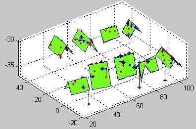
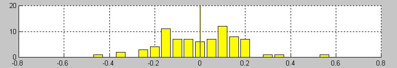
4 Figure 3: Laser points and planar roof segments before transformation (first set). Figure 7: Laser points and planar roof segments before transformation (second set). Figure 4: Elevation differences between laser points and measured planar roof segments before transformation (first set). Figure 8: Elevation differences between laser points and measured planar roof segments before transformation (second set). Figure 5: Laser points and planar roof segments after transformation (first set). Figure 9: Laser points and planar roof segments after transformation (second set). Figure 6: Elevation differences between laser points and measured planar roof segments after transformation (first set). Figure 10: Elevation differences between laser points and measured planar roof segments after transformation (second set).
5 4 SUMMARY Laser scanning is a novel approach for measuring surface elevations, from which digital surface models can be extracted easily and efficiently. However, laser measurements may suffer from systematic errors and from errors occurring near surface discontinuities. Integration of laser data with information available from aerial images is expected to render better surfaces. In order to integrate these two sources of information, they must be related to the same coordinate frame. A method developed for matching two surfaces and transforming one to the other has been presented. The method was tested both with synthetic and with real data and found stable and accurate. While testing the method, systematic differences between the two surfaces have been found. Future work should concentrate on analyzing the possible sources for these differences. Further work is also required in the area of analyzing surface characteristics for determining what transformation parameters can be calculated using the described algorithm. ACKNOWLEDGMENT This research project is partially supported by the United States- Israel Binational Science Foundation, research grant no REFERENCES Ackermann, F., Airborne laser scanning present status and future expectations. ISPRS Journal of Photogrammetry and Remote Sensing, 54(1), pp Axelsson, P., Processing of laser scanner data - algorithms and applications. ISPRS Journal of Photogrammetry and Remote Sensing, 54(1), pp Baltsavias, E., A comparison between photogrammetry and laser scanning. ISPRS Journal of Photogrammetry and Remote Sensing, 54(1), pp Brenner, C., Interactive modeling tools for 3D building reconstruction. Proceedings, 47 th Photogrammetric Week, Stuttgart, Wichmann, pp Csathó, B., Schenk, T., Lee, D.-C. and Filin, S., Inclusion of multispectral data into object recognition. International Archives of Photogrammetry and Remote Sensing, Valladolid, Spain, Vol. XXXII, Part 7-4-3W6, 8 pages. Fritsch, D., Virtual cities and landscape models what has photogrammetry to offer? Proceedings, 47 th Photogrammetric Week, Stuttgart, Wichmann, pp Haala, N., Combining multiple data sources for urban data acquisition. Proceedings, 47 th Photogrammetric Week, Stuttgart, Wichmann, pp Haala, N. and Anders, K.-H., Acquisition of 3D urban models by analysis of aerial images, digital surface models and existing 2D building information. Proceedings, SPIE, Vol. 3115, pp Kilian, J., Haala, N., and Englich, M., Capture and evaluation of airborne laser scanner data. International Archives of Photogrammetry and Remote Sensing, Vienna, Vol. XXXI, Part B3, pp Kraus, K., Photogrammetry, Vol. 1, Dümmler, Bonn. Toth, C. and Grejner-Brzezinska, D., Improved DEM extraction techniques - combining LIDAR data with direct digital GPS/INS orientated imagery. Proceedings, International Workshop on Mobile Mapping Technology, Bangkok, Thailand. Vosselman, G., Building reconstruction using planar faces in very high density height data. International Archives of Photogrammetry and Remote Sensing, Vol. XXXII, Part 3-2W5, pp
BUILDING MODEL RECONSTRUCTION FROM DATA INTEGRATION INTRODUCTION
 BUILDING MODEL RECONSTRUCTION FROM DATA INTEGRATION Ruijin Ma Department Of Civil Engineering Technology SUNY-Alfred Alfred, NY 14802 mar@alfredstate.edu ABSTRACT Building model reconstruction has been
HEURISTIC FILTERING AND 3D FEATURE EXTRACTION FROM LIDAR DATA
 HEURISTIC FILTERING AND 3D FEATURE EXTRACTION FROM LIDAR DATA Abdullatif Alharthy, James Bethel School of Civil Engineering, Purdue University, 1284 Civil Engineering Building, West Lafayette, IN 47907
ACCURACY STUDY OF AIRBORNE LASER SCANNING DATA WITH PHOTOGRAMMETRY
 ACCURACY STUDY OF AIRBORNE LASER SCANNING DATA WITH PHOTOGRAMMETRY Toni Schenk 1, Suyoung Seo 1,Beáta Csathó 2 1 Department of Civil and Environmental Engineering and Geodetic Science 2 Byrd Polar Research
A METHOD TO PREDICT ACCURACY OF LEAST SQUARES SURFACE MATCHING FOR AIRBORNE LASER SCANNING DATA SETS
 A METHOD TO PREDICT ACCURACY OF LEAST SQUARES SURFACE MATCHING FOR AIRBORNE LASER SCANNING DATA SETS Robert Pâquet School of Engineering, University of Newcastle Callaghan, NSW 238, Australia (rpaquet@mail.newcastle.edu.au)
FOOTPRINTS EXTRACTION
 Building Footprints Extraction of Dense Residential Areas from LiDAR data KyoHyouk Kim and Jie Shan Purdue University School of Civil Engineering 550 Stadium Mall Drive West Lafayette, IN 47907, USA {kim458,
AUTOMATIC GENERATION OF DIGITAL BUILDING MODELS FOR COMPLEX STRUCTURES FROM LIDAR DATA
 AUTOMATIC GENERATION OF DIGITAL BUILDING MODELS FOR COMPLEX STRUCTURES FROM LIDAR DATA Changjae Kim a, Ayman Habib a, *, Yu-Chuan Chang a a Geomatics Engineering, University of Calgary, Canada - habib@geomatics.ucalgary.ca,
Building Segmentation and Regularization from Raw Lidar Data INTRODUCTION
 Building Segmentation and Regularization from Raw Lidar Data Aparajithan Sampath Jie Shan Geomatics Engineering School of Civil Engineering Purdue University 550 Stadium Mall Drive West Lafayette, IN 47907-2051
The suitability of airborne laser scanner data for automatic 3D object reconstruction
 The suitability of airborne laser scanner data for automatic 3D object reconstruction H.-G. Maas Institute of Photogrammetry and Remote Sensing, Dresden Technical University, Dresden, Germany ABSTRACT:
BUILDING DETECTION AND STRUCTURE LINE EXTRACTION FROM AIRBORNE LIDAR DATA
 BUILDING DETECTION AND STRUCTURE LINE EXTRACTION FROM AIRBORNE LIDAR DATA C. K. Wang a,, P.H. Hsu a, * a Dept. of Geomatics, National Cheng Kung University, No.1, University Road, Tainan 701, Taiwan. China-
BUILDING EXTRACTION AND RECONSTRUCTION FROM LIDAR DATA. Zheng Wang. EarthData International Gaithersburg, Maryland USA
 BUILDING EXTRACTION AND RECONSTRUCTION FROM LIDAR DATA Zheng Wang EarthData International Gaithersburg, Maryland USA zwang@earthdata.com Tony Schenk Department of Civil Engineering The Ohio State University
Automatic DTM Extraction from Dense Raw LIDAR Data in Urban Areas
 Automatic DTM Extraction from Dense Raw LIDAR Data in Urban Areas Nizar ABO AKEL, Ofer ZILBERSTEIN and Yerach DOYTSHER, Israel Key words: LIDAR, DSM, urban areas, DTM extraction. SUMMARY Although LIDAR
LIDAR Data for Photogrammetric Georeferencing
 LIDAR Data for Photogrammetric Georeferencing Ayman HABIB, Mwafag GHANMA and Eui-Myoung KIM, Canada Key words: laser scanning, photogrammetry, triangulation, linear-features, absolute orientation, registration.
THE USE OF ANISOTROPIC HEIGHT TEXTURE MEASURES FOR THE SEGMENTATION OF AIRBORNE LASER SCANNER DATA
 THE USE OF ANISOTROPIC HEIGHT TEXTURE MEASURES FOR THE SEGMENTATION OF AIRBORNE LASER SCANNER DATA Sander Oude Elberink* and Hans-Gerd Maas** *Faculty of Civil Engineering and Geosciences Department of
[Youn *, 5(11): November 2018] ISSN DOI /zenodo Impact Factor
![[Youn *, 5(11): November 2018] ISSN DOI /zenodo Impact Factor](/thumbs/91/105079225.jpg "[Youn *, 5(11): November 2018] ISSN DOI /zenodo Impact Factor") GLOBAL JOURNAL OF ENGINEERING SCIENCE AND RESEARCHES AUTOMATIC EXTRACTING DEM FROM DSM WITH CONSECUTIVE MORPHOLOGICAL FILTERING Junhee Youn *1 & Tae-Hoon Kim 2 *1,2 Korea Institute of Civil Engineering
GLOBAL JOURNAL OF ENGINEERING SCIENCE AND RESEARCHES AUTOMATIC EXTRACTING DEM FROM DSM WITH CONSECUTIVE MORPHOLOGICAL FILTERING Junhee Youn *1 & Tae-Hoon Kim 2 *1,2 Korea Institute of Civil Engineering
AUTOMATIC IMAGE ORIENTATION BY USING GIS DATA
 AUTOMATIC IMAGE ORIENTATION BY USING GIS DATA Jeffrey J. SHAN Geomatics Engineering, School of Civil Engineering Purdue University IN 47907-1284, West Lafayette, U.S.A. jshan@ecn.purdue.edu Working Group
AUTOMATIC EXTRACTION OF LARGE COMPLEX BUILDINGS USING LIDAR DATA AND DIGITAL MAPS
 AUTOMATIC EXTRACTION OF LARGE COMPLEX BUILDINGS USING LIDAR DATA AND DIGITAL MAPS Jihye Park a, Impyeong Lee a, *, Yunsoo Choi a, Young Jin Lee b a Dept. of Geoinformatics, The University of Seoul, 90
Unwrapping of Urban Surface Models
 Unwrapping of Urban Surface Models Generation of virtual city models using laser altimetry and 2D GIS Abstract In this paper we present an approach for the geometric reconstruction of urban areas. It is
Interpretation of Urban Surface Models using 2D Building Information Norbert Haala and Claus Brenner Institut fur Photogrammetrie Universitat Stuttgar
 Interpretation of Urban Surface Models using 2D Building Information Norbert Haala and Claus Brenner Institut fur Photogrammetrie Universitat Stuttgart Geschwister-Scholl-Strae 24, 70174 Stuttgart, Germany
Aalborg Universitet. Published in: Accuracy Publication date: Document Version Early version, also known as pre-print
 Aalborg Universitet A method for checking the planimetric accuracy of Digital Elevation Models derived by Airborne Laser Scanning Høhle, Joachim; Øster Pedersen, Christian Published in: Accuracy 2010 Publication
MONO-IMAGE INTERSECTION FOR ORTHOIMAGE REVISION
 MONO-IMAGE INTERSECTION FOR ORTHOIMAGE REVISION Mohamed Ibrahim Zahran Associate Professor of Surveying and Photogrammetry Faculty of Engineering at Shoubra, Benha University ABSTRACT This research addresses
REFINEMENT OF FILTERED LIDAR DATA USING LOCAL SURFACE PROPERTIES INTRODUCTION
 REFINEMENT OF FILTERED LIDAR DATA USING LOCAL SURFACE PROPERTIES Suyoung Seo, Senior Research Associate Charles G. O Hara, Associate Research Professor GeoResources Institute Mississippi State University
FILTERING OF DIGITAL ELEVATION MODELS
 FILTERING OF DIGITAL ELEVATION MODELS Dr. Ing. Karsten Jacobsen Institute for Photogrammetry and Engineering Survey University of Hannover, Germany e-mail: jacobsen@ipi.uni-hannover.de Dr. Ing. Ricardo
REGISTRATION OF AIRBORNE LASER DATA WITH ONE AERIAL IMAGE
 REGISTRATION OF AIRORNE LASER DATA WITH ONE AERIAL IMAGE Michel ROUX GET - Télécom-Paris - UMR 5141 LTCI - Département TSI 4 rue arrault, 75013 Paris - France michel.roux@enst.fr KEY WORDS: Airborne Laser
GENERATING BUILDING OUTLINES FROM TERRESTRIAL LASER SCANNING
 GENERATING BUILDING OUTLINES FROM TERRESTRIAL LASER SCANNING Shi Pu International Institute for Geo-information Science and Earth Observation (ITC), Hengelosestraat 99, P.O. Box 6, 7500 AA Enschede, The
Processing of laser scanner data algorithms and applications
 Ž. ISPRS Journal of Photogrammetry & Remote Sensing 54 1999 138 147 Processing of laser scanner data algorithms and applications Peter Axelsson ) Department of Geodesy and Photogrammetry, Royal Institute
Planimetric and height accuracy of airborne laserscanner data: User requirements and system performance
 Maas 117 Planimetric and height accuracy of airborne laserscanner data: User requirements and system performance HANS-GERD MAAS, Dresden University of Technology ABSTRACT Motivated by the primary use for
AUTOMATIC EXTRACTION OF BUILDING FEATURES FROM TERRESTRIAL LASER SCANNING
 AUTOMATIC EXTRACTION OF BUILDING FEATURES FROM TERRESTRIAL LASER SCANNING Shi Pu and George Vosselman International Institute for Geo-information Science and Earth Observation (ITC) spu@itc.nl, vosselman@itc.nl
Chapters 1 7: Overview
 Chapters 1 7: Overview Photogrammetric mapping: introduction, applications, and tools GNSS/INS-assisted photogrammetric and LiDAR mapping LiDAR mapping: principles, applications, mathematical model, and
PHOTOGRAMMETRY AND LASER ALTIMETRY. Toni Schenk Department of Civil and Environmental Engineering and Geodetic Science, OSU
 PHOTOGRAMMETR AND LASER ALTIMETR Toni Schenk Department of Civil and Environmental Engineering and Geodetic Science, OSU schenk.2@osu.edu KE WORDS: Photogrammetry, Laser Ranging, DTM generation, Surface
Automated Extraction of Buildings from Aerial LiDAR Point Cloud and Digital Imaging Datasets for 3D Cadastre - Preliminary Results
 Automated Extraction of Buildings from Aerial LiDAR Point Cloud and Digital Imaging Datasets for 3D Pankaj Kumar 1*, Alias Abdul Rahman 1 and Gurcan Buyuksalih 2 ¹Department of Geoinformation Universiti
Building Boundary Tracing and Regularization from Airborne Lidar Point Clouds
 Building Boundary Tracing and Regularization from Airborne Lidar Point Clouds Aparajithan Sampath and Jie Shan Abstract Building boundary is necessary for the real estate industry, flood management, and
EFFECTS OF DIFFERENT LASER SCANNING MODES ON THE RESULTS OF BUILDING RECOGNITION AND RECONSTRUCTION
 EFFECTS OF DIFFERENT LASER SCANNING MODES ON THE RESULTS OF BUILDING RECOGNITION AND RECONSTRUCTION Eberhard STEINLE, Thomas VÖGTLE University of Karlsruhe, Germany Institute of Photogrammetry and Remote
SURFACE ESTIMATION BASED ON LIDAR. Abstract
 Published in: Proceedings of the ASPRS Annual Conference. St. Louis, Missouri, April 2001. SURFACE ESTIMATION BASED ON LIDAR Wolfgang Schickler Anthony Thorpe Sanborn 1935 Jamboree Drive, Suite 100 Colorado
WAVELET AND SCALE-SPACE THEORY IN SEGMENTATION OF AIRBORNE LASER SCANNER DATA
 WAVELET AND SCALE-SPACE THEORY IN SEGMENTATION OF AIRBORNE LASER SCANNER DATA T.Thuy VU, Mitsuharu TOKUNAGA Space Technology Applications and Research Asian Institute of Technology P.O. Box 4 Klong Luang,
Research on-board LIDAR point cloud data pretreatment
 Acta Technica 62, No. 3B/2017, 1 16 c 2017 Institute of Thermomechanics CAS, v.v.i. Research on-board LIDAR point cloud data pretreatment Peng Cang 1, Zhenglin Yu 1, Bo Yu 2, 3 Abstract. In view of the
Least-Squares Matching with Airborne Laserscanning Data in a TIN Structure
 Least-Squares Matching with Airborne Laserscanning Data in a TIN Structure Hans-Gerd Maas Institute of Photogrammetry and Remote Sensing Dresden Technical University Helmholtzstr. 1 D-162 Dresden, Germany
A DATA DRIVEN METHOD FOR FLAT ROOF BUILDING RECONSTRUCTION FROM LiDAR POINT CLOUDS
 A DATA DRIVEN METHOD FOR FLAT ROOF BUILDING RECONSTRUCTION FROM LiDAR POINT CLOUDS A. Mahphood, H. Arefi *, School of Surveying and Geospatial Engineering, College of Engineering, University of Tehran,
Fast determination of parametric house models from dense airborne laserscanner data
 Fast determination of parametric house models from dense airborne laserscanner data Hans-Gerd Maas Faculty of Civil Engineering and Geosciences Section of hotogrammetry and Remote Sensing Delft University
COMBINING HIGH RESOLUTION SATELLITE IMAGERY AND AIRBORNE LASER SCANNING DATA FOR GENERATING BARELAND DEM IN URBAN AREAS
 COMBINING HIGH RESOLUTION SATELLITE IMAGERY AND AIRBORNE LASER SCANNING DATA FOR GENERATING BARELAND IN URBAN AREAS Guo Tao *, Yoshifumi Yasuoka Institute of Industrial Science, University of Tokyo, 4-6-1
International Archives of Photogrammetry and Remote Sensing. Vol. XXXII, Part 5. Hakodate 1998
 International Archives of Photogrammetry and Remote Sensing. Vol. XXXII, Part 5. Hakodate 1998 RAPID ACQUISITION OF VIRTUAL REALITY CITY MODELS FROM MULTIPLE DATA SOURCES Claus Brenner and Norbert Haala
DETERMINATION OF CORRESPONDING TRUNKS IN A PAIR OF TERRESTRIAL IMAGES AND AIRBORNE LASER SCANNER DATA
 The Photogrammetric Journal of Finland, 20 (1), 2006 Received 31.7.2006, Accepted 13.11.2006 DETERMINATION OF CORRESPONDING TRUNKS IN A PAIR OF TERRESTRIAL IMAGES AND AIRBORNE LASER SCANNER DATA Olli Jokinen,
A COMPETITION BASED ROOF DETECTION ALGORITHM FROM AIRBORNE LIDAR DATA
 A COMPETITION BASED ROOF DETECTION ALGORITHM FROM AIRBORNE LIDAR DATA HUANG Xianfeng State Key Laboratory of Informaiton Engineering in Surveying, Mapping and Remote Sensing (Wuhan University), 129 Luoyu
FAST REGISTRATION OF TERRESTRIAL LIDAR POINT CLOUD AND SEQUENCE IMAGES
 FAST REGISTRATION OF TERRESTRIAL LIDAR POINT CLOUD AND SEQUENCE IMAGES Jie Shao a, Wuming Zhang a, Yaqiao Zhu b, Aojie Shen a a State Key Laboratory of Remote Sensing Science, Institute of Remote Sensing
A STUDY ON ROOF POINT EXTRACTION BASED ON ROBUST ESTIMATION FROM AIRBORNE LIDAR DATA
 Journal of the Chinese Institute of Engineers, Vol. 31, No. 4, pp. 537-550 (2008) 537 A STUDY ON ROOF POINT EXTRACTION BASED ON ROBUST ESTIMATION FROM AIRBORNE LIDAR DATA Shih-Hong Chio ABSTRACT The airborne
Digital Surface Models for Building Extraction
 in: Automatic Extraction of Man-Made Structures from Aerial and Space Images (II), Birkhäuser, Basel Digital Surface Models for Building Extraction Uwe Weidner Institut für Photogrammetrie Rheinische Friedrich
MATLAB and photogrammetric applications
 MALAB and photogrammetric applications Markéta Potůčková Department of applied geoinformatics and cartography Faculty of cience, Charles University in Prague Abstract Many automated processes in digital
A QUALITY ASSESSMENT OF AIRBORNE LASER SCANNER DATA
 A QUALITY ASSESSMENT OF AIRBORNE LASER SCANNER DATA E. Ahokas, H. Kaartinen, J. Hyyppä Finnish Geodetic Institute, Geodeetinrinne 2, 243 Masala, Finland Eero.Ahokas@fgi.fi KEYWORDS: LIDAR, accuracy, quality,
Experiments on Generation of 3D Virtual Geographic Environment Based on Laser Scanning Technique
 Experiments on Generation of 3D Virtual Geographic Environment Based on Laser Scanning Technique Jie Du 1, Fumio Yamazaki 2 Xiaoyong Chen 3 Apisit Eiumnoh 4, Michiro Kusanagi 3, R.P. Shrestha 4 1 School
Multi-ray photogrammetry: A rich dataset for the extraction of roof geometry for 3D reconstruction
 Multi-ray photogrammetry: A rich dataset for the extraction of roof geometry for 3D reconstruction Andrew McClune, Pauline Miller, Jon Mills Newcastle University David Holland Ordnance Survey Background
EVALUATION OF WORLDVIEW-1 STEREO SCENES AND RELATED 3D PRODUCTS
 EVALUATION OF WORLDVIEW-1 STEREO SCENES AND RELATED 3D PRODUCTS Daniela POLI, Kirsten WOLFF, Armin GRUEN Swiss Federal Institute of Technology Institute of Geodesy and Photogrammetry Wolfgang-Pauli-Strasse
Polyhedral Building Model from Airborne Laser Scanning Data**
 GEOMATICS AND ENVIRONMENTAL ENGINEERING Volume 4 Number 4 2010 Natalia Borowiec* Polyhedral Building Model from Airborne Laser Scanning Data** 1. Introduction Lidar, also known as laser scanning, is a
INTEGRATED SENSORS FOR PLATFORM ORIENTATION AND TOPOGRAPHIC DATA ACQUISITION
 Symposium on Digital Photogrammetry, Istanbul, May 21-22, 1998 1 INTEGRATED SENSORS FOR PLATFORM ORIENTATION AND TOPOGRAPHIC DATA ACQUISITION Peter Axelsson Department of Geodesy and Photogrammetry, Royal
1. Introduction. A CASE STUDY Dense Image Matching Using Oblique Imagery Towards All-in- One Photogrammetry
 Submitted to GIM International FEATURE A CASE STUDY Dense Image Matching Using Oblique Imagery Towards All-in- One Photogrammetry Dieter Fritsch 1, Jens Kremer 2, Albrecht Grimm 2, Mathias Rothermel 1
EPIPOLAR IMAGES FOR CLOSE RANGE APPLICATIONS
 EPIPOLAR IMAGES FOR CLOSE RANGE APPLICATIONS Vassilios TSIOUKAS, Efstratios STYLIANIDIS, Petros PATIAS The Aristotle University of Thessaloniki, Department of Cadastre Photogrammetry and Cartography Univ.
BUILDING ROOF RECONSTRUCTION BY FUSING LASER RANGE DATA AND AERIAL IMAGES
 BUILDING ROOF RECONSTRUCTION BY FUSING LASER RANGE DATA AND AERIAL IMAGES J.J. Jaw *,C.C. Cheng Department of Civil Engineering, National Taiwan University, 1, Roosevelt Rd., Sec. 4, Taipei 10617, Taiwan,
FAST PRODUCTION OF VIRTUAL REALITY CITY MODELS
 FAST PRODUCTION OF VIRTUAL REALITY CITY MODELS Claus Brenner and Norbert Haala Institute for Photogrammetry (ifp) University of Stuttgart Geschwister-Scholl-Straße 24, 70174 Stuttgart, Germany Ph.: +49-711-121-4097,
Comeback of Digital Image Matching
 Photogrammetric Week '09 Dieter Fritsch (Ed.) Wichmann Verlag, Heidelberg, 2009 Haala 289 Comeback of Digital Image Matching NORBERT HAALA, Stuttgart ABSTRACT Despite the fact that tools for automatic
CO-REGISTERING AND NORMALIZING STEREO-BASED ELEVATION DATA TO SUPPORT BUILDING DETECTION IN VHR IMAGES
 CO-REGISTERING AND NORMALIZING STEREO-BASED ELEVATION DATA TO SUPPORT BUILDING DETECTION IN VHR IMAGES Alaeldin Suliman, Yun Zhang, Raid Al-Tahir Department of Geodesy and Geomatics Engineering, University
Post-mission Adjustment Methods of Airborne Laser Scanning Data
 Kris MORIN, USA and Dr. Naser EL-SHEIMY, Canada Key words: ALS, LIDAR, adjustment, calibration, laser scanner. ABSTRACT Airborne Laser Scanners (ALS) offer high speed, high accuracy and quick deployment
A FFT BASED METHOD OF FILTERING AIRBORNE LASER SCANNER DATA
 A FFT BASED METHOD OF FILTERING AIRBORNE LASER SCANNER DATA U. Marmol, J. Jachimski University of Science and Technology in Krakow, Poland Department of Photogrammetry and Remote Sensing Informatics (entice,
Improvement of the Edge-based Morphological (EM) method for lidar data filtering
 method for lidar data filtering") International Journal of Remote Sensing Vol. 30, No. 4, 20 February 2009, 1069 1074 Letter Improvement of the Edge-based Morphological (EM) method for lidar data filtering QI CHEN* Department of Geography,
International Journal of Remote Sensing Vol. 30, No. 4, 20 February 2009, 1069 1074 Letter Improvement of the Edge-based Morphological (EM) method for lidar data filtering QI CHEN* Department of Geography,
BUNDLE BLOCK ADJUSTMENT WITH HIGH RESOLUTION ULTRACAMD IMAGES
 BUNDLE BLOCK ADJUSTMENT WITH HIGH RESOLUTION ULTRACAMD IMAGES I. Baz*, G. Buyuksalih*, K. Jacobsen** * BIMTAS, Tophanelioglu Cad. ISKI Hizmet Binasi No:62 K.3-4 34460 Altunizade-Istanbul, Turkey gb@bimtas.com.tr
KEY WORDS: Laser altimetry, Error recovery, Strip adjustment, Segmentation
 Analysis and implementation of a laser strip adjustment model Sagi Filin Department of Geodesy, Faculty of Civil Engineering and Geosciences Delft University of Technology, The Netherlands s.filin@citg.tudelft.nl
AUTOMATED CALIBRATION TECHNIQUE FOR PHOTOGRAMMETRIC SYSTEM BASED ON A MULTI-MEDIA PROJECTOR AND A CCD CAMERA
 AUTOMATED CALIBRATION TECHNIQUE FOR PHOTOGRAMMETRIC SYSTEM BASED ON A MULTI-MEDIA PROJECTOR AND A CCD CAMERA V. A. Knyaz * GosNIIAS, State Research Institute of Aviation System, 539 Moscow, Russia knyaz@gosniias.ru
Construction of Complex City Landscape with the Support of CAD Model
 Construction of Complex City Landscape with the Support of CAD Model MinSun 1 JunChen 2 AinaiMa 1 1.Institute of RS & GIS, Peking University, Beijing, China, 100871 2.National Geomatics Center of China,
NATIONWIDE POINT CLOUDS AND 3D GEO- INFORMATION: CREATION AND MAINTENANCE GEORGE VOSSELMAN
 NATIONWIDE POINT CLOUDS AND 3D GEO- INFORMATION: CREATION AND MAINTENANCE GEORGE VOSSELMAN OVERVIEW National point clouds Airborne laser scanning in the Netherlands Quality control Developments in lidar
Semi-Automatic Approach for Building Reconstruction Using SPLIT-MERGE-SHAPE Method
 Semi-Automatic Approach for Building Reconstruction Using SPLIT-MERGE-SHAPE Method Jiann-Yeou RAU, Liang-Chien CHEN Tel: 886-3-4227151 Ext. 7651,7627,7622 Fax: 886-3-4255535 {jyrau, lcchen} @csrsr.ncu.edu.tw
BUILDING BOUNDARY EXTRACTION FROM HIGH RESOLUTION IMAGERY AND LIDAR DATA
 BUILDING BOUNDARY EXTRACTION FROM HIGH RESOLUTION IMAGERY AND LIDAR DATA Liang Cheng, Jianya Gong, Xiaoling Chen, Peng Han State Key Laboratory of Information Engineering in Surveying, Mapping and Remote
3D BUILDINGS MODELLING BASED ON A COMBINATION OF TECHNIQUES AND METHODOLOGIES
 3D BUILDINGS MODELLING BASED ON A COMBINATION OF TECHNIQUES AND METHODOLOGIES Georgeta Pop (Manea), Alexander Bucksch, Ben Gorte Delft Technical University, Department of Earth Observation and Space Systems,
APPLICABILITY ANALYSIS OF CLOTH SIMULATION FILTERING ALGORITHM FOR MOBILE LIDAR POINT CLOUD
 APPLICABILITY ANALYSIS OF CLOTH SIMULATION FILTERING ALGORITHM FOR MOBILE LIDAR POINT CLOUD Shangshu Cai 1,, Wuming Zhang 1,, Jianbo Qi 1,, Peng Wan 1,, Jie Shao 1,, Aojie Shen 1, 1 State Key Laboratory
DIGITAL SURFACE MODELS OF CITY AREAS BY VERY HIGH RESOLUTION SPACE IMAGERY
 DIGITAL SURFACE MODELS OF CITY AREAS BY VERY HIGH RESOLUTION SPACE IMAGERY Jacobsen, K. University of Hannover, Institute of Photogrammetry and Geoinformation, Nienburger Str.1, D30167 Hannover phone +49
DOCUMENTATION AND VISUALIZATION OF ANCIENT BURIAL MOUNDS BY HELICOPTER LASER SURVEYING
 DOCUMENTATION AND VISUALIZATION OF ANCIENT BURIAL MOUNDS BY HELICOPTER LASER SURVEYING Tsutomu Kakiuchi a *, Hirofumi Chikatsu b, Haruo Sato c a Aero Asahi Corporation, Development Management Division,
Performance Evaluation of Optech's ALTM 3100: Study on Geo-Referencing Accuracy
 Performance Evaluation of Optech's ALTM 3100: Study on Geo-Referencing Accuracy R. Valerie Ussyshkin, Brent Smith, Artur Fidera, Optech Incorporated BIOGRAPHIES Dr. R. Valerie Ussyshkin obtained a Ph.D.
Intensity Augmented ICP for Registration of Laser Scanner Point Clouds
 Intensity Augmented ICP for Registration of Laser Scanner Point Clouds Bharat Lohani* and Sandeep Sashidharan *Department of Civil Engineering, IIT Kanpur Email: blohani@iitk.ac.in. Abstract While using
SEMANTIC FEATURE BASED REGISTRATION OF TERRESTRIAL POINT CLOUDS
 SEMANTIC FEATURE BASED REGISTRATION OF TERRESTRIAL POINT CLOUDS A. Thapa*, S. Pu, M. Gerke International Institute for Geo-Information Science and Earth Observation (ITC), Hengelosestraat 99, P.O.Box 6,
REPRESENTATION REQUIREMENTS OF AS-IS BUILDING INFORMATION MODELS GENERATED FROM LASER SCANNED POINT CLOUD DATA
 REPRESENTATION REQUIREMENTS OF AS-IS BUILDING INFORMATION MODELS GENERATED FROM LASER SCANNED POINT CLOUD DATA Engin Burak Anil 1 *, Burcu Akinci 1, and Daniel Huber 2 1 Department of Civil and Environmental
Geometric Accuracy Evaluation, DEM Generation and Validation for SPOT-5 Level 1B Stereo Scene
 Geometric Accuracy Evaluation, DEM Generation and Validation for SPOT-5 Level 1B Stereo Scene Buyuksalih, G.*, Oruc, M.*, Topan, H.*,.*, Jacobsen, K.** * Karaelmas University Zonguldak, Turkey **University
Airborne Laser Scanning and Derivation of Digital Terrain Models 1
 Airborne Laser Scanning and Derivation of Digital Terrain Models 1 Christian Briese, Norbert Pfeifer Institute of Photogrammetry and Remote Sensing Vienna University of Technology Gußhausstraße 27-29,
ACCURATE BUILDING OUTLINES FROM ALS DATA
 ACCURATE BUILDING OUTLINES FROM ALS DATA Clode S.P. a, Kootsookos P.J. a, Rottensteiner F. b a The Intelligent Real-Time Imaging and Sensing Group School of Information Technology & Electrical Engineering
AUTOMATIC INTERPRETATION OF HIGH RESOLUTION SAR IMAGES: FIRST RESULTS OF SAR IMAGE SIMULATION FOR SINGLE BUILDINGS
 AUTOMATIC INTERPRETATION OF HIGH RESOLUTION SAR IMAGES: FIRST RESULTS OF SAR IMAGE SIMULATION FOR SINGLE BUILDINGS J. Tao *, G. Palubinskas, P. Reinartz German Aerospace Center DLR, 82234 Oberpfaffenhofen,
GRAPHICS TOOLS FOR THE GENERATION OF LARGE SCALE URBAN SCENES
 GRAPHICS TOOLS FOR THE GENERATION OF LARGE SCALE URBAN SCENES Norbert Haala, Martin Kada, Susanne Becker, Jan Böhm, Yahya Alshawabkeh University of Stuttgart, Institute for Photogrammetry, Germany Forename.Lastname@ifp.uni-stuttgart.de
DIGITAL TERRAIN MODELS
 DIGITAL TERRAIN MODELS 1 Digital Terrain Models Dr. Mohsen Mostafa Hassan Badawy Remote Sensing Center GENERAL: A Digital Terrain Models (DTM) is defined as the digital representation of the spatial distribution
Investigation of Sampling and Interpolation Techniques for DEMs Derived from Different Data Sources
 Investigation of Sampling and Interpolation Techniques for DEMs Derived from Different Data Sources FARRAG ALI FARRAG 1 and RAGAB KHALIL 2 1: Assistant professor at Civil Engineering Department, Faculty
THE PHOTOGRAMMETRIC DERIVATION OF DIGITAL TERRAIN MODELS IN BUILT-UP AREAS. Geoinformatics and Cartography, Czech Republic
 The Photogrammetric Journal of Finland, Vol. 22, No. 1, 2010 Received 18.9.2009, Accepted 21.05.2010 THE PHOTOGRAMMETRIC DERIVATION OF DIGITAL TERRAIN MODELS IN BUILT-UP AREAS Joachim Höhle 1, Christian
The raycloud A Vision Beyond the Point Cloud
 The raycloud A Vision Beyond the Point Cloud Christoph STRECHA, Switzerland Key words: Photogrammetry, Aerial triangulation, Multi-view stereo, 3D vectorisation, Bundle Block Adjustment SUMMARY Measuring
AUTOMATIC BUILDING DETECTION FROM LIDAR POINT CLOUD DATA
 AUTOMATIC BUILDING DETECTION FROM LIDAR POINT CLOUD DATA Nima Ekhtari, M.R. Sahebi, M.J. Valadan Zoej, A. Mohammadzadeh Faculty of Geodesy & Geomatics Engineering, K. N. Toosi University of Technology,
PERFORMANCE OF LARGE-FORMAT DIGITAL CAMERAS
 PERFORMANCE OF LARGE-FORMAT DIGITAL CAMERAS K. Jacobsen Institute of Photogrammetry and GeoInformation, Leibniz University Hannover, Germany jacobsen@ipi.uni-hannover.de Inter-commission WG III/I KEY WORDS:
APPLICATION AND ACCURACY EVALUATION OF LEICA ADS40 FOR LARGE SCALE MAPPING
 APPLICATION AND ACCURACY EVALUATION OF LEICA ADS40 FOR LARGE SCALE MAPPING WenYuan Hu a, GengYin Yang b, Hui Yuan c,* a, b ShanXi Provincial Survey and Mapping Bureau, China - sxgcchy@public.ty.sx.cn c
DMC - Practical Experiences and Photogrammetric System Performance
 Photogrammetric Week '03 Dieter Fritsch (Ed.) Wichmann Verlag, Heidelberg, 2003 Dörstel 59 DMC - Practical Experiences and Photogrammetric System Performance CHRISTOPH DÖRSTEL, Z/I Imaging, Aalen ABSTRACT
RANSAC APPROACH FOR AUTOMATED REGISTRATION OF TERRESTRIAL LASER SCANS USING LINEAR FEATURES
 RANSAC APPROACH FOR AUTOMATED REGISTRATION OF TERRESTRIAL LASER SCANS USING LINEAR FEATURES K. AL-Durgham, A. Habib, E. Kwak Department of Geomatics Engineering, University of Calgary, Calgary, Alberta,
COMPARISON OF TREE EXTRACTION FROM INTENSITY DROP AND FROM MULTIPLE RETURNS IN ALS DATA
 COMPARISON OF TREE EXTRACTION FROM INTENSITY DROP AND FROM MULTIPLE RETURNS IN ALS DATA C.Örmeci a, S.Cesur b a ITU, Civil Engineering Faculty, 80626 Maslak Istanbul, Turkey ormeci@itu.edu.tr b ITU, Informatics
Matching Topographic Surfaces: Application to lidar and photogrammetric surfaces.
 Matching Topographic Surfaces: Application to lidar and photogrammetric surfaces. Frédéric Bretar a,b, Michel Roux b, Marc Pierrot-Deseilligny a a Institut Géographique National 2-4 Av. Pasteur 94165 St.
DENSE 3D POINT CLOUD GENERATION FROM UAV IMAGES FROM IMAGE MATCHING AND GLOBAL OPTIMAZATION
 DENSE 3D POINT CLOUD GENERATION FROM UAV IMAGES FROM IMAGE MATCHING AND GLOBAL OPTIMAZATION S. Rhee a, T. Kim b * a 3DLabs Co. Ltd., 100 Inharo, Namgu, Incheon, Korea ahmkun@3dlabs.co.kr b Dept. of Geoinformatic
The Photogrammetric Derivation of Digital Terrain Models in Built-up Areas Høhle, Joachim; Øster Pedersen, Christian; Bayer, Tomas; Frederiksen, Poul
 Aalborg Universitet The Photogrammetric Derivation of Digital Terrain Models in Built-up Areas Høhle, Joachim; Øster Pedersen, Christian; Bayer, Tomas; Frederiksen, Poul Published in: Photogrammetric Journal
DEVELOPMENT OF ORIENTATION AND DEM/ORTHOIMAGE GENERATION PROGRAM FOR ALOS PRISM
 DEVELOPMENT OF ORIENTATION AND DEM/ORTHOIMAGE GENERATION PROGRAM FOR ALOS PRISM Izumi KAMIYA Geographical Survey Institute 1, Kitasato, Tsukuba 305-0811 Japan Tel: (81)-29-864-5944 Fax: (81)-29-864-2655
COMPARATIVE ANALYSIS OF DIFFERENT LIDAR SYSTEM CALIBRATION TECHNIQUES
 COMPARATIVE ANALYSIS OF DIFFERENT LIDAR SYSTEM CALIBRATION TECHNIQUES M. Miller a, A. Habib a a Digitial Photogrammetry Research Group Lyles School of Civil Engineering Purdue University, 550 Stadium Mall
An Introduction to Lidar & Forestry May 2013
 An Introduction to Lidar & Forestry May 2013 Introduction to Lidar & Forestry Lidar technology Derivatives from point clouds Applied to forestry Publish & Share Futures Lidar Light Detection And Ranging
City-Modeling. Detecting and Reconstructing Buildings from Aerial Images and LIDAR Data
 City-Modeling Detecting and Reconstructing Buildings from Aerial Images and LIDAR Data Department of Photogrammetrie Institute for Geodesy and Geoinformation Bonn 300000 inhabitants At river Rhine University
THREE-DIMENSIONAL MODELLING OF BREAKLINES FROM AIRBORNE LASER SCANNER DATA
 THREE-DIMENSIONAL MODELLING OF BREAKLINES FROM AIRBORNE LASER SCANNER DATA Christian Briese Institute of Photogrammetry and Remote Sensing Vienna University of Technology, Gußhausstraße 27-29, A-1040 Vienna,
Automatic Building Extrusion from a TIN model Using LiDAR and Ordnance Survey Landline Data
 Automatic Building Extrusion from a TIN model Using LiDAR and Ordnance Survey Landline Data Rebecca O.C. Tse, Maciej Dakowicz, Christopher Gold and Dave Kidner University of Glamorgan, Treforest, Mid Glamorgan,