OLERDOLA S CAVE, CATALONIA, PAST AND PRESENT: A VIRTUAL REALITY RECONSTRUCTION FROM TERRESTRIAL LASER SCANNER AND GIS DATA
|
|
|
- Shana Fitzgerald
- 5 years ago
- Views:
Transcription
1 LM VC OLERDOLA S CAVE, CATALONIA, PAST AND PRESENT: A RECONSTRUCTION FROM TERRESTRIAL AND GIS DATA B. Pucci a, A. Marambio a a Virtual City Modelling Lab, Politecnical University of Catalonia, Barcelona, Spain barbara.pucci@upc.edu, alejandro.marambio@upc.edu


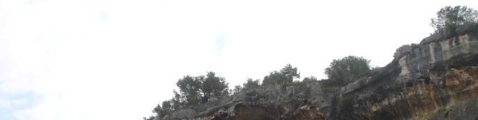
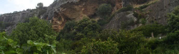
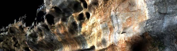
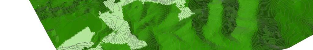
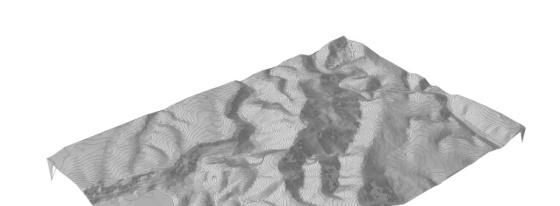
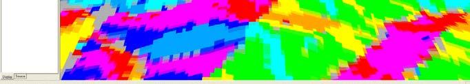
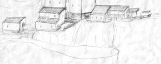
2 1. OLERDOLA S CAVE The The cave... goal of the project: is To located perform 60km a digital west reproduction from Barcelona of the cave and of has its a surroundings size of 150 meters long by 20 meters high presents To use a fast difficult and accurate accessibility technology is To still create in the an process interactive of excavation 3d environment shares To support a complex the archaeologist geometry virtual restitution of different has two hypothesis main chambers of the ancient buildings.
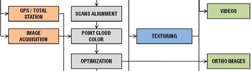
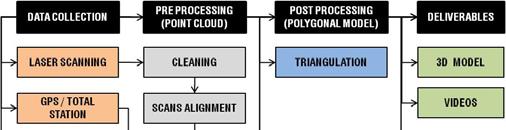
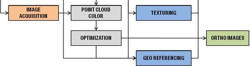
3 2. PROJECT WORKFLOW Ortho Images Videos Point Cloud Model LASER SCANNER Polygonal Textured Model PLATFORM GIS Viewshed Shadow Slope Simulation Augmented Reality
4 3. TERRESTRIAL


5 4. TERRESTRIAL Data collection: RIEGL LMS Z420i and Nikon D100 One field day 28 scan positions 0.1º FOV 80x180º) 1,5 million points per scan 70 calibrated images No registration targets 2 scanpositions Image acquisition


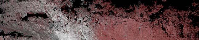
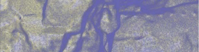
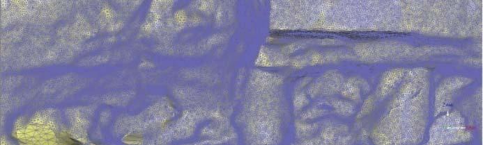
6 5. TERRESTRIAL Point Cloud Processing: 3 Day elaboration: Cleaning unwanted data Aligning scan position Fixing colour ofthe images Optimizing the resolution Raw point cloud model 46,3 millions points 790Mb Optimized point cloud model 22,6 millions points 198Mb Plan, section and facade ortho images 100pixel/cm resolution HD videos Facade Image 100pix/cm by Pointools

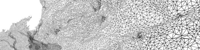

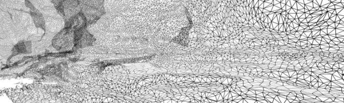

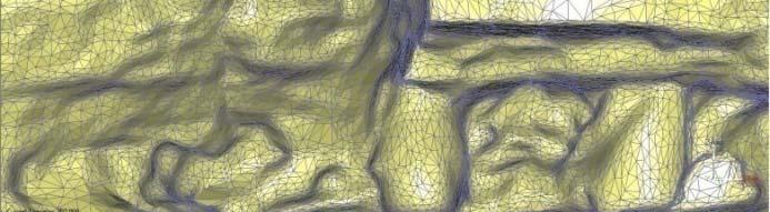


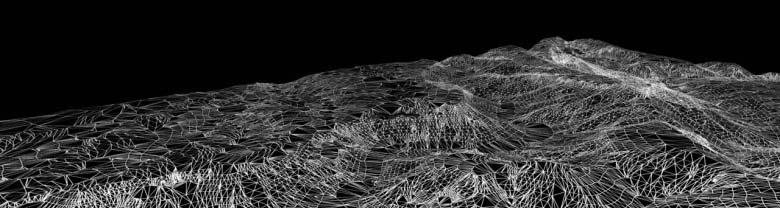
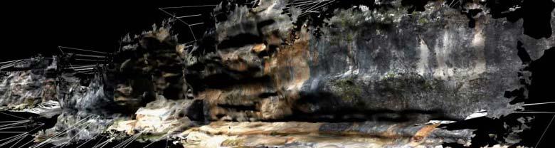
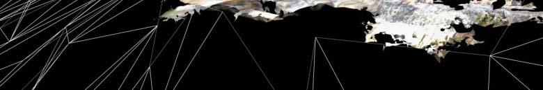
7 6. TERRESTRIAL Post Processing () Triangulation of the optimized point cloud RAW Model: 45 millions polygons, 250Mb Decimation i Model: 4 millions polygons, 50Mb Texture Application 140 images (3008x2000pixel) 22,5 millions polygons 250MB Wireframe model 4 millions polygons 50MB Textured model
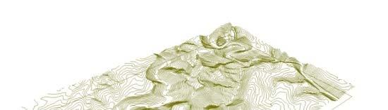

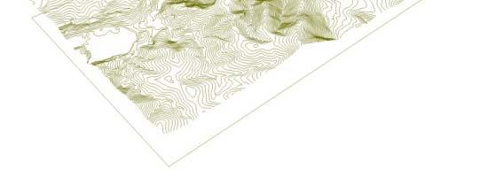


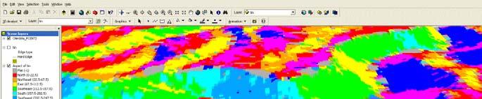
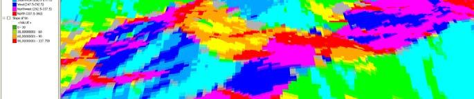

8 7. GIS APLICATION Gis Aplication ICC Web: DXF Curves 1:5000 MrSID Ortho Image 1:5000 Arc Scene TIN analysis: Viewshed Slope Shadow
9 8. GIS Model Point Cloud Model Conversion Plugin Workbench Hardware ALICE Software Real Time Visualization Group Visualization PLATFORM Stereoscopic vision Easy Position Tracking Collaboration workspace Augmented Reality


10 9. Alice Software: High quality visualization thanks to the use of different algorithms and other high end technologies. High range of navigation i options accessible trough classic interactivei hardware or using different tracking devices. Stereoscopic vision from different virtual reality hardware: 3d glasses, head mounted displays, CAVE, PowerWall and Workbench. Space referenced sound Collaboration workspace Plugin for importing VRML97 (WRL), AutoCAD (DXF), y 3DStudio MAX 4.0(MAX) files


11 9. The Workbench: Can be be moved to any particular location Can be shown to a group of people instead of being single user Position in virtual environment can be easily located for tracking purposes MIRROR SCREEN 2 DLP PROJECTORS MOUSE SENSORS CPU


12 10.
13 11. GIS LASE ER SCANNE ER ADVANTAGES Is a valid alternative where traditional survey techniques doesn t give enough information for complex 3d models environments Data collection is fast and accurate. Enriches the 3d virtual environment, allowing different standard analysis to work interactively with the virtual model. There are many free available databases online, which can be used to adequately represent the context. Allows laser scanner and GIS data real time visualization. Permits a first class interaction between different users and complex data by easy position tracking. PROBLEMS AND POSSIBLE SOLUTIONS The triangulation of a point cloud is not a standard process, is still significantly time consuming. Moreover, accuracy lost in this process cannot be exactly controlled. The development of tools able to introduce a dense colored high resolution point cloud in the Virtual Reality platform could permit to reduce the post processing time and to maintain all laser measurement. More possibilities of exploiting GIS data in Virtual environments need further studies to be tested at different level of detail and scales Flexibility of data integration must be improved and high resolution visualization can be implemented. A more portable and easy to use device is needed. This work in progress project opens new future scenarios, in which a more portable and easy to use device can be applied and an augmented reality application can be developed.


14 www-upc.es/lmvc VIRTUAL CITY MODELING LAB Universitat Politècnica de Catalunya Barcelona, SPAIN
The Processing of Laser Scan Data for the Analysis of Historic Structures in Ireland
 The 7th International Symposium on Virtual Reality, Archaeology and Cultural Heritage VAST (2006) M. Ioannides, D. Arnold, F. Niccolucci, K. Mania (Editors) The Processing of Laser Scan Data for the Analysis
TERRESTRIAL LASER SCANNER, TERRESTRIAL SYNTHETIC APERTURE RADAR, AND TOPOGRAPHIC DATA: AN INTEGRATION PROPOSAL.
 TERRESTRIAL LASER SCANNER, TERRESTRIAL SYNTHETIC APERTURE RADAR, AND TOPOGRAPHIC DATA: AN INTEGRATION PROPOSAL. Alejandro Marambio, Barbara Pucci Virtual City Modeling Lab, Politecnical University of Catalonia
Unwrapping of Urban Surface Models
 Unwrapping of Urban Surface Models Generation of virtual city models using laser altimetry and 2D GIS Abstract In this paper we present an approach for the geometric reconstruction of urban areas. It is
TLS Parameters, Workflows and Field Methods
 TLS Parameters, Workflows and Field Methods Marianne Okal, UNAVCO June 20 th, 2014 How a Lidar instrument works (Recap) Transmits laser signals and measures the reflected light to create 3D point clouds.
Viewer, Editor & Meter (Beta) User manual Department of Cartographic Engineering, Geodesy and Photogrammetry
 User manual Department of Cartographic Engineering, Geodesy and Photogrammetry") Viewer, Editor & Meter (Beta) User manual July 27, 2013 Department of Cartographic Engineering, Geodesy and Photogrammetry Index 1. Presentation... 2 2. Installing software... 2 3. Main window... 2 3.1.
Viewer, Editor & Meter (Beta) User manual July 27, 2013 Department of Cartographic Engineering, Geodesy and Photogrammetry Index 1. Presentation... 2 2. Installing software... 2 3. Main window... 2 3.1.
3D Terrestrial Laser Scanner Innovative Applications for 3D Documentation
 3D Terrestrial Laser Scanner Innovative Applications for 3D Documentation Rodney Chaffee Head of Sales, FARO Asia Pacific 3D Laser Scaning Market 2017 2.3 Billion $ 2012 1.3 Billion $ CAGR : > 12% Source:
New Requirements for the Relief in the Topographic Databases of the Institut Cartogràfic de Catalunya
 New Requirements for the Relief in the Topographic Databases of the Institut Cartogràfic de Catalunya Blanca Baella, Maria Pla Institut Cartogràfic de Catalunya, Barcelona, Spain Abstract Since 1983 the
Automated Processing for 3D Mosaic Generation, a Change of Paradigm
 Automated Processing for 3D Mosaic Generation, a Change of Paradigm Frank BIGNONE, Japan Key Words: 3D Urban Model, Street Imagery, Oblique imagery, Mobile Mapping System, Parallel processing, Digital
Leica Cyclone 5.4 Technical Specifications
 Leica Cyclone 5.4 Technical Specifications HDS Scanner control and operation Scan Scan Scan Register Model Survey Viewer Acquire and display image Acquire image at specified resolution (high, medium, low)
3D MODELING OF CLOSE-RANGE OBJECTS: PHOTOGRAMMETRY OR LASER SCANNING?
 3D MODELING OF CLOSE-RANGE OBJECTS: PHOTOGRAMMETRY OR LASER SCANNING? F. Remondino 1 A. Guarnieri 2 A. Vettore 2 1 Institute of Geodesy and Photogrammetry ETH Hönggerberg - Zurich, Switzerland e-mail:
Integrated Projects. Madonna di Pietranico Pompeii insula V1 V I S UA L COMPUTING L A B I ST I - C N R
 Integrated Projects Madonna di Pietranico Pompeii insula V1 V I S UA L COMPUTING L A B I ST I - C N R La Madonna di Pietranico Pietranico s Madonna Terracotta statue, destroyed by an earthquake. We used
Active Stereo Vision. COMP 4900D Winter 2012 Gerhard Roth
 Active Stereo Vision COMP 4900D Winter 2012 Gerhard Roth Why active sensors? Project our own texture using light (usually laser) This simplifies correspondence problem (much easier) Pluses Can handle different
Terrestrial 3D laser scanning Practical aspects
 Terrestrial 3D laser scanning Practical aspects ISPRS WG VI/5&SC Summer School 2007 by Gregor Bilban 3D laser scanning Benefits Lower data collection costs Reduction or elimination of re-visits More accurate
With FARO PointSense for Revit. Jörg Braunes Platform Owner Software Chris Palmer Sales Engineer 1
 From Point Clouds to BIM Models With FARO PointSense for Revit Jörg Braunes Platform Owner Software Chris Palmer Sales Engineer 1 Agenda Scan to BIM with Revit PointClouds in Revit Advanced Workflow with
3GSM GmbH. Plüddemanngasse 77 A-8010 Graz, Austria Tel Fax:
 White Paper Graz, April 2014 3GSM GmbH Plüddemanngasse 77 A-8010 Graz, Austria Tel. +43-316-464744 Fax: +43-316-464744-11 office@3gsm.at www.3gsm.at Measurement and assessment of rock and terrain surfaces
RIEGL LMS-Q780. The Versatile, High Altitude Airborne LIDAR Sensor
 RIEGL LMS-Q780 4700m 400kHz The full waveform airborne laser scanner offers great versatility, accuracy, and data quality. The scanner enables you to successfully deliver your projects with industry leading
Fusion of laser scanning and Photogrammetric data for the documentation and VR visualization of an archaeological tomb complex
 Presented at the FIG Congress 2018, May 6-11, 2018 in Istanbul, Turkey Fusion of laser scanning and Photogrammetric data for the documentation and VR visualization of an archaeological tomb complex E.
Comparing Aerial Photogrammetry and 3D Laser Scanning Methods for Creating 3D Models of Complex Objects
 Comparing Aerial Photogrammetry and 3D Laser Scanning Methods for Creating 3D Models of Complex Objects A Bentley Systems White Paper Cyril Novel Senior Software Engineer, Bentley Systems Renaud Keriven
The benefit of Terrestrial Laser Scanner for archaeology
 The benefit of Terrestrial Laser Scanner for archaeology Christian RUDORFER City of Vienna / MA41 Urban Survey Abstract: In 2010, the MA 41 - Urban Survey of the City of Vienna decided to purchase a terrestrial
Comparing Aerial Photogrammetry and 3D Laser Scanning Methods for Creating 3D Models of Complex Objects
 www.bentley.com Comparing Aerial Photogrammetry and 3D Laser Scanning Methods for Creating 3D Models of Complex Objects A Bentley White Paper Cyril Novel Senior Software Engineer, Bentley Systems Renaud
Redefining Airborne LiDAR Introduction to RIEGL LMS in Airborne LiDAR
 Redefining Airborne LiDAR Introduction to RIEGL LMS in Airborne LiDAR Andres Vargas Integration Systems Engineer LAGF Mexico City, Mexico September 23th, 2014 1 Airborne Laser Scanning History and Evolution
INTEGRATED MODELING SYSTEMS FOR 3D VISION
 INTEGRATED MODELING SYSTEMS FOR 3D VISION A. Guarnieri a, R. M. Levy b, A. Vettore a a CIRGEO Interdept. Research Center of Geomatics, University of Padova, Italy - cirgeo@unipd.it b Faculty of Environmental
HIGH-PERFORMANCE LONG-RANGE LASER SCANNER WITH CALIBRATED DIGITAL CAMERA: A HYBRID 3D LASER SENSOR SYSTEM
 HIGH-PERFORMANCE LONG-RANGE LASER SCANNER WITH CALIBRATED DIGITAL CAMERA: A HYBRID 3D LASER SENSOR SYSTEM ANDREAS ULLRICH Technical Director RIEGL Laser Measurement Systems GmbH Horn, Austria www.riegl.co.at
SINGLE IMAGE ORIENTATION USING LINEAR FEATURES AUTOMATICALLY EXTRACTED FROM DIGITAL IMAGES
 SINGLE IMAGE ORIENTATION USING LINEAR FEATURES AUTOMATICALLY EXTRACTED FROM DIGITAL IMAGES Nadine Meierhold a, Armin Schmich b a Technical University of Dresden, Institute of Photogrammetry and Remote
A Comparison between Active and Passive 3D Vision Sensors: BumblebeeXB3 and Microsoft Kinect
 A Comparison between Active and Passive 3D Vision Sensors: BumblebeeXB3 and Microsoft Kinect Diana Beltran and Luis Basañez Technical University of Catalonia, Barcelona, Spain {diana.beltran,luis.basanez}@upc.edu
TLS Parameters, Workflows and Field Methods
 TLS Parameters, Workflows and Field Methods Marianne Okal, UNAVCO GSA, September 23 rd, 2016 How a Lidar instrument works (Recap) Transmits laser signals and measures the reflected light to create 3D point
Version 6.1 Release Notes September 2016
 Version 6.1 Release Notes September 2016 Copyright 2016 FARO. All rights reserved. No part of this publication may be reproduced or transmitted in any form or by any means without written permission of
Intelligent photogrammetry. Agisoft
 Intelligent photogrammetry Agisoft Agisoft Metashape is a cutting edge software solution, with its engine core driving photogrammetry to its ultimate limits, while the whole system is designed to deliver
Advanced point cloud processing
 Advanced point cloud processing George Vosselman ITC Enschede, the Netherlands INTERNATIONAL INSTITUTE FOR GEO-INFORMATION SCIENCE AND EARTH OBSERVATION Laser scanning platforms Airborne systems mounted
Revealing the. Stonehenge. In a major project for English Heritage, Through 3D Digital Modelling. By Neil McLeod
 Revealing the Secrets of Stonehenge Through 3D Digital Modelling In a major project for English Heritage, survey specialists Greenhatch Group used laser scanning, digital photogrammetry and Geomagic Studio
SENSOR FUSION: GENERATING 3D BY COMBINING AIRBORNE AND TRIPOD- MOUNTED LIDAR DATA
 International Archives of the Photogrammetry, Remote Sensing and Spatial Information Sciences, Vol. XXXIV-5/W10 SENSOR FUSION: GENERATING 3D BY COMBINING AIRBORNE AND TRIPOD- MOUNTED LIDAR DATA A. Iavarone
Sensor Fusion: Generating 3D by Combining Airborne and Tripod mounted LIDAR Data
 Sensor Fusion: Generating 3D by Combining Airborne and Tripod mounted LIDAR Data Albert IAVARONE and Daina VAGNERS, Canada Key Words: LIDAR, Laser scanning, Remote sensing, Active sensors, 3D modeling,
MODELING CITY HALL S FAÇADE USING LASER SCANNING TECHNOLOGY
 Преглед НЦД 15 (2009), 59 63 Vladimir Pajić, Dušan Jovanović Miro Govedarica (Faculty of Technical Sciences, Novi Sad, Serbia) MODELING CITY HALL S FAÇADE USING LASER SCANNING TECHNOLOGY Abstract. This
ROAD-SCANNER COMPACT APPLICATION FIELDS MAIN FEATURES
 ROAD-SCANNER COMPACT Mobile Mapping System by GEXCEL & SITECO collaboration A smaller mobile system for asset management and cartography suited for ZOLLER & FRÖHLICH PROFILER 9012 laser scanner. 2 + 3
BIM & Digital Transformation Scotland Live 2018 Capturing 3D Reality at the push of a button
 BIM & Digital Transformation Scotland Live 2018 Capturing 3D Reality at the push of a button Gary Kelly Country Manager Scotland Leica Geosystems @LeicaScot Capturing 3D Reality at the push of a button
Mixed-Reality for Intuitive Photo-Realistic 3D-Model Generation
 Mixed-Reality for Intuitive Photo-Realistic 3D-Model Generation Wolfgang Sepp, Tim Bodenmueller, Michael Suppa, and Gerd Hirzinger DLR, Institut für Robotik und Mechatronik @ GI-Workshop VR/AR 2009 Folie
GENERATING BUILDING OUTLINES FROM TERRESTRIAL LASER SCANNING
 GENERATING BUILDING OUTLINES FROM TERRESTRIAL LASER SCANNING Shi Pu International Institute for Geo-information Science and Earth Observation (ITC), Hengelosestraat 99, P.O. Box 6, 7500 AA Enschede, The
Rapid generation of 3D GIS content from reality capture data sources. Keir Keightley, HDR
 Rapid generation of 3D GIS content from reality capture data sources Keir Keightley, HDR Purpose Why do we want 3D GIS content? A picture is worth a thousand words, and more, if you can navigate it in
Data Integration in Building Virtual Models
 Data Integration in Building Virtual Models Erik Singels, Geospatial Information Sciences Program Brent Vollmar, Department of Geosciences Adewale Okunoren, Department of Geosciences Carlos L. V. Aiken,
RIEGL LMS-Q780. The Versatile, High Altitude Airborne LIDAR Sensor
 RIEGL LMS-Q780 3050m 400kHz The full waveform airborne laser scanner offers great versatility, accuracy, and data quality. The scanner enables you to successfully deliver your projects with industry leading
ENY-C2005 Geoinformation in Environmental Modeling Lecture 4b: Laser scanning
 1 ENY-C2005 Geoinformation in Environmental Modeling Lecture 4b: Laser scanning Petri Rönnholm Aalto University 2 Learning objectives To recognize applications of laser scanning To understand principles
TLS Parameters, Workflows and Field Methods
 TLS Parameters, Workflows and Field Methods Marianne Okal, UNAVCO GSA, October 20 th, 2017 How a Lidar instrument works (Recap) Transmits laser signals and measures the reflected light to create 3D point
CSE 165: 3D User Interaction. Lecture #3: Displays
 CSE 165: 3D User Interaction Lecture #3: Displays CSE 165 -Winter 2016 2 Announcements Homework Assignment #1 Due Friday at 2:00pm To be presented in CSE lab 220 Paper presentations Title/date due by entering
Sirovision TM Release 6.0 Release Notes
 2014-2015 Sirovision TM Release 6.0 Release Notes. Contents 2014-2015 Whats new in Sirovision 6?... 1 New GUI Design... 1 The new Explorer Window... 2 New Icons... 3 Performance Improvements... 5 Reduction
STUDIO 13 THE BEST JUST GOT MUCH BETTER WHAT S NEW TO ARTEC
 WHAT S NEW TO ARTEC STUDIO 13 THE BEST JUST GOT MUCH BETTER Each year, Artec 3D overhauls the performance and features of the Artec Studio software, developing new and exciting tools, as well as streamlining
Federica Zampa Sineco SpA V. le Isonzo, 14/1, Milan, 20135, Italy
 LYNX MOBILE MAPPER TM : THE NEW SURVEY TECHNOLOGY Federica Zampa Sineco SpA V. le Isonzo, 14/1, Milan, 20135, Italy federica.zampa@sineco.co.it Dario Conforti Optech Incorporated 300 Interchange Way, Vaughan,
Laser Scanning. 3D Model is not existing and is required for: studies revamping maintenance HSE integration in another 3D model archiving
 Laser Scanning Laser Scanning Laser scanning is used whenever: 3D Model is not existing and is required for: studies revamping maintenance HSE integration in another 3D model archiving 2 Object acquisition
Aerial and Mobile LiDAR Data Fusion
 Creating Value Delivering Solutions Aerial and Mobile LiDAR Data Fusion Dr. Srini Dharmapuri, CP, PMP What You Will Learn About LiDAR Fusion Mobile and Aerial LiDAR Technology Components & Parameters Project
Computer Vision. 3D acquisition
 è Computer 3D acquisition Acknowledgement Courtesy of Prof. Luc Van Gool 3D acquisition taxonomy s image cannot currently be displayed. 3D acquisition methods Thi passive active uni-directional multi-directional
Historic Building Information Modelling Phd
 Dublin Institute of Technology From the SelectedWorks of Maurice Murphy Spring April 3, 2012 Historic Building Information Modelling Phd Maurice Murphy, Dublin Institute of Technology Available at: https://works.bepress.com/maurice_murphy/8/
DIGITAL ARCHIVING IN CULTURAL HERITAGE PRESERVATION
 DIGITAL ARCHIVING IN CULTURAL HERITAGE PRESERVATION HUNG-MING CHENG, YA-NING YEN, WUN-BIN YANG China University of Technology, Taiwan hungmc@cute.edu.tw, alexyen@cute.edu.tw, wunbin@gmail.com Abstract.
Bentley Descartes and what s new in Descartes V8i (SELECTseries 3) What is Bentley Descartes? 2011 Bentley Systems, Incorporated
 What is Bentley Descartes? 2011 Bentley Systems, Incorporated") Bentley Descartes and what s new in Descartes V8i (SELECTseries 3) Tom Stogdill Bentley Systems, Inc. What is Bentley Descartes? Image Processing Raster Geo-Referencing Advanced raster transformation (warping,
Bentley Descartes and what s new in Descartes V8i (SELECTseries 3) Tom Stogdill Bentley Systems, Inc. What is Bentley Descartes? Image Processing Raster Geo-Referencing Advanced raster transformation (warping,
Agenda. DLP 3D scanning Introduction DLP 3D scanning SDK Introduction Advance features for existing SDK
 Agenda DLP 3D scanning Introduction DLP 3D scanning SDK Introduction Advance features for existing SDK Increasing scanning speed from 20Hz to 400Hz Improve the lost point cloud 3D Machine Vision Applications:
CSE 165: 3D User Interaction
 CSE 165: 3D User Interaction Lecture #4: Displays Instructor: Jurgen Schulze, Ph.D. CSE 165 - Winter 2015 2 Announcements Homework Assignment #1 Due tomorrow at 1pm To be presented in CSE lab 220 Homework
A Strategy and Vision for Enterprise 3D GIS. B r o o k s P a t r i c k A c c o u n t E x e c u t i v e b p a t r i c e s r i.
 A Strategy and Vision for Enterprise 3D GIS B r o o k s P a t r i c k A c c o u n t E x e c u t i v e b p a t r i c k @ e s r i. c o m Understanding where things are, and why, is essential for rational
SURVEY 3.0. Innovative field solutions for Surveyors X PAD. works when you do
 Innovative field solutions for Surveyors works when you do X PAD INNOVATIVE FIELD SOLUTION FOR SURVEYORS The software for survey, stakeout and control, ensuring productivity and flexibility in the field,
VMX -2HA RIEGL. High Speed, High Performance Dual Scanner Mobile Mapping System. Typical Applications
 RIEGL 420m 2 MHz VMX -2HA optional High-Speed 10 GigE Link for acquisition of 2 million measurements/sec and image data of up to 9 different high-end cameras The is a High Speed, High Performance Dual
ARCHITECTURE. - this is just a selection of the many opportunities using Eyesmap -
 Create orthophotos, 3D models, wireframe models of exteriors, facades or indoor structures. Use it for rehabilitation, 3D documentation, fast measurements or depth and accurate analysis (sections, plans,
ADVANCING REALITY MODELING WITH CONTEXTCAPTURE
 ADVANCING REALITY MODELING WITH CONTEXTCAPTURE Knowing the existing conditions of a project is a key asset in any decision process. Governments need to better know their territories, through mapping operations,
Digital Softcopy Photogrammetry
 LLP Erasmus IP EPOCHE 2013 Thassos Island, Greece, 2-16 June 2013 Digital Softcopy Photogrammetry Prof. Levente DIMEN The 1 Decembrie 1918 University of Alba Iulia, Romania GENERAL CONTEXT In the last
Trimble VISION Positions from Pictures
 Trimble VISION Positions from Pictures This session will cover What Is Trimble VISION? Trimble VISION Portfolio What Do you Need? How Does It Work & How Accurate Is It? Applications Resources Trimble VISION
StreetMapper 360 & StreetMapper Portable
 StreetMapper 360 & StreetMapper Portable 11th February 2010 Dr. Chris Cox & Mr. Olaf Gross 3D Laser Mapping LIDAR Specialists StreetMapper Distributor for RIEGL (UK, Ireland, Southern Africa) Terrasolid
FILTER PACKAGE USER S GUIDE
 FILTER PACKAGE USER S GUIDE 1 CONTENT I. Introduction... 3 II. Installation... 3 III. Using the filters... 4 a- General... 4 b- Edge filter... 5 c- Uniform filter... 7 d- Angular filter... 8 e- Circle
Structured Light. Tobias Nöll Thanks to Marc Pollefeys, David Nister and David Lowe
 Structured Light Tobias Nöll tobias.noell@dfki.de Thanks to Marc Pollefeys, David Nister and David Lowe Introduction Previous lecture: Dense reconstruction Dense matching of non-feature pixels Patch-based
Italian pavilion in 3D, project for EXPO 2015, Milan (Italy) JRC 3D RECONSTRUCTOR POWERFUL. ADVANCED. PROFESSIONAL
 JRC 3D RECONSTRUCTOR POWERFUL. ADVANCED. PROFESSIONAL") Italian pavilion in 3D, project for EXPO 2015, Milan (Italy) JRC 3D RECONSTRUCTOR POWERFUL. ADVANCED. PROFESSIONAL OVERVIEW JRC 3D Reconstructor is the well known multi-platform and multi-resolution software
Italian pavilion in 3D, project for EXPO 2015, Milan (Italy) JRC 3D RECONSTRUCTOR POWERFUL. ADVANCED. PROFESSIONAL OVERVIEW JRC 3D Reconstructor is the well known multi-platform and multi-resolution software
APPROACH FOR MESH OPTIMIZATION AND 3D WEB VISUALIZATION
 APPROACH FOR MESH OPTIMIZATION AND 3D WEB VISUALIZATION Pavel I. Hristov 1, Emiliyan G. Petkov 2 1 Pavel I. Hristov Faculty of Mathematics and Informatics, St. Cyril and St. Methodius University, Veliko
THREE-DIMENSIONAL MAPPING OF AN ANCIENT CAVE PAINTINGS USING CLOSE-RANGE PHOTOGRAMMETRY AND TERRESTRIAL LASER SCANNING TECHNOLOGIES
 THREE-DIMENSIONAL MAPPING OF AN ANCIENT CAVE PAINTINGS USING CLOSE-RANGE PHOTOGRAMMETRY AND TERRESTRIAL LASER SCANNING TECHNOLOGIES Z. Majid a, M. F. M. Ariff a, K. M. Idris a, A. R. Yusoff a, K.M. Idris
Location Based Technology Expert. Mobile VR 3D modeling for BIM
 Location Based Technology Expert Mobile VR 3D modeling for BIM 50bln square meters indoor environment are waiting to be digitized and go online. So we need a way efficient enough to map the indoors VR
Bumblebee2 Stereo Vision Camera
 Bumblebee2 Stereo Vision Camera Description We use the Point Grey Bumblebee2 Stereo Vision Camera in this lab section. This stereo camera can capture 648 x 488 video at 48 FPS. 1) Microlenses 2) Status
Presented at the FIG Congress 2018, May 6-11, 2018 in Istanbul, Turkey
 Presented at the FIG Congress 2018, May 6-11, 2018 in Istanbul, Turkey Evangelos MALTEZOS, Charalabos IOANNIDIS, Anastasios DOULAMIS and Nikolaos DOULAMIS Laboratory of Photogrammetry, School of Rural
3D SPATIAL DATA ACQUISITION AND MODELING OF ANGHEL SALIGNY MONUMENT USING TERRESTRIAL LASER SCANNING
 JOURNAL OF APPLIED ENGINEERING SCIENCES VOL. 2(15), issue 2_2012 ISSN 2247-3769 ISSN-L 2247-3769 (Print) / e-issn:2284-7197 3D SPATIAL DATA ACQUISITION AND MODELING OF ANGHEL SALIGNY MONUMENT USING TERRESTRIAL
Competence in Optical 3D Measuring
 Competence in Optical 3D Measuring Competence in Optical 3D Measuring The QTSculptor System QTSculptor is a complete system for the accurate 3D measuring of real world objects. The basic components are
BE INSPIRED.
 BE INSPIRED www.scaninabox.com Last update October 2017 PROFESSIONALISM, OUR CORE Accurately manufactured in every detail, Scan in a Box FX offers high quality 3D Scans. The Made in Italy design has been
High Resolution Laserscanning, not only for 3D-City Models
 Lohr 133 High Resolution Laserscanning, not only for 3D-City Models UWE LOHR, Ravensburg ABSTRACT The TopoSys laserscanner system is designed to produce digital elevation models (DEMs) of the environment
OBJECT MANAGER PACKAGE USER S GUIDE
 OBJECT MANAGER PACKAGE USER S GUIDE 1 CONTENT I. Introduction... 3 II. Installation... 3 III. Using the plugins... 4 a- General... 4 b- Object properties manager... 4 c- Pipe manager... 6 d- Plane manager...
3D Laser Scanning Technology. Fast, Safe, Accurate. Rugged hardware and powerful software combined with streamlined survey workflow
 3D Laser Scanning Technology Fast, Safe, Accurate Rugged hardware and powerful software combined with streamlined survey workflow Maptek specialises in the research, development and application of 3D laser
Introduction to 3D Machine Vision
 Introduction to 3D Machine Vision 1 Many methods for 3D machine vision Use Triangulation (Geometry) to Determine the Depth of an Object By Different Methods: Single Line Laser Scan Stereo Triangulation
Tutorial (Beginner level): Orthomosaic and DEM Generation with Agisoft PhotoScan Pro 1.3 (with Ground Control Points)
: Orthomosaic and DEM Generation with Agisoft PhotoScan Pro 1.3 (with Ground Control Points)") Tutorial (Beginner level): Orthomosaic and DEM Generation with Agisoft PhotoScan Pro 1.3 (with Ground Control Points) Overview Agisoft PhotoScan Professional allows to generate georeferenced dense point
Tutorial (Beginner level): Orthomosaic and DEM Generation with Agisoft PhotoScan Pro 1.3 (with Ground Control Points) Overview Agisoft PhotoScan Professional allows to generate georeferenced dense point
Three-Dimensional Laser Scanner. Field Evaluation Specifications
 Stanford University June 27, 2004 Stanford Linear Accelerator Center P.O. Box 20450 Stanford, California 94309, USA Three-Dimensional Laser Scanner Field Evaluation Specifications Metrology Department
Terrain Modeling and Mapping for Telecom Network Installation Using Scanning Technology. Maziana Muhamad
 Terrain Modeling and Mapping for Telecom Network Installation Using Scanning Technology Maziana Muhamad Summarising LiDAR (Airborne Laser Scanning) LiDAR is a reliable survey technique, capable of: acquiring
Automatic 3-D 3 D Model Acquisition from Range Images. Michael K. Reed and Peter K. Allen Computer Science Department Columbia University
 Automatic 3-D 3 D Model Acquisition from Range Images Michael K. Reed and Peter K. Allen Computer Science Department Columbia University Introduction Objective: given an arbitrary object or scene, construct
Processing 3D Surface Data
 Processing 3D Surface Data Computer Animation and Visualisation Lecture 17 Institute for Perception, Action & Behaviour School of Informatics 3D Surfaces 1 3D surface data... where from? Iso-surfacing
Lecture 8 Active stereo & Volumetric stereo
 Lecture 8 Active stereo & Volumetric stereo Active stereo Structured lighting Depth sensing Volumetric stereo: Space carving Shadow carving Voxel coloring Reading: [Szelisky] Chapter 11 Multi-view stereo
TOPOSCOPY, A CLOSE RANGE PHOTOGRAMMETRIC SYSTEM FOR ARCHITECTS AND LANDSCAPE DESIGNERS
 TOPOSCOPY, A CLOSE RANGE PHOTOGRAMMETRIC SYSTEM FOR ARCHITECTS AND LANDSCAPE DESIGNERS A. C. Groneman-van der Hoeven Bureau Toposcopie, Bachlaan 78, 6865 ES Doorwerth, The Netherlands. info@toposcopie.nl
Speed, Accuracy and Performance at an Affordable Price
 Speed, Accuracy and Performance at an Affordable Price 012 2.A ions olut S 3D3 ed. serv s re ht ll rig VERSATILE for Industry Applications The HDI Advance 3D Scanner uses white light technology for capturing
Cultural Heritage. Geometric Recording of Cultural Monuments. Basic Principles of Geometric Recording. Specific requirements
 LOW COST DIGITAL PHOTOGRAMMETRIC TECHNIQUES FOR THE DOCUMENTATION OF CULTURAL HERITAGE Ch. Ioannidis, S. Soile, C. Potsiou Lab. of Photogrammetry School of Rural & Surveying Eng. National Technical University
GRAPHICS TOOLS FOR THE GENERATION OF LARGE SCALE URBAN SCENES
 GRAPHICS TOOLS FOR THE GENERATION OF LARGE SCALE URBAN SCENES Norbert Haala, Martin Kada, Susanne Becker, Jan Böhm, Yahya Alshawabkeh University of Stuttgart, Institute for Photogrammetry, Germany Forename.Lastname@ifp.uni-stuttgart.de
Displayed with permission The American Surveyor April/May Copyright 2009 Cheves Media
 NASA s Environmental Simulation Chamber A at the Johnson Space Center in Houston will require upgrades to accommodate testing of components for the new space telescopes. Laser scanning with the FARO LS
Outline of Presentation. Introduction to Overwatch Geospatial Software Feature Analyst and LIDAR Analyst Software
 Outline of Presentation Automated Feature Extraction from Terrestrial and Airborne LIDAR Presented By: Stuart Blundell Overwatch Geospatial - VLS Ops Co-Author: David W. Opitz Overwatch Geospatial - VLS
Surveying like never before
 CAD functionalities GCP Mapping and Aerial Image Processing Software for Land Surveying Specialists Surveying like never before www.3dsurvey.si Modri Planet d.o.o., Distributors: info@3dsurvey.si +386
Messerli Informatik GmbH EliteCAD ME V13 R2 update information 1
 Messerli Informatik GmbH EliteCAD ME V13 R2 update information 1 EliteCAD ME V13 R2 update information February 2016 This update of EliteCAD ME contains numerous improvements and optimizations which have
Digital Preservation of the Aurelius Church and the Hirsau Museum Complex by Means of HDS and Photogrammetric Texture Mapping
 Master Thesis Ruxandra MOROSAN Ruxandra MOROSAN Digital Preservation of the Aurelius Church and the Hirsau Museum Complex by Means of HDS and Photogrammetric Texture Mapping Duration of the Thesis: 6 months
A NEW TOOL FOR ARCHITECTURAL PHOTOGRAMMETRY: THE 3D NAVIGATOR S. Dequal, A. Lingua, F. Rinaudo - Politecnico di Torino - ITALY
 A NEW TOOL FOR ARCHITECTURAL PHOTOGRAMMETRY: THE 3D NAVIGATOR S. Dequal, A. Lingua, F. Rinaudo - Politecnico di Torino - ITALY KEY WORDS: 3D navigation, Digital Images, LIS, Archiving, ABSTRACT People
Towards Optimal 3D Point Clouds
 By Andreas Nüchter, Jan Elseberg and Dorit Borrmann, Germany feature Automation in 3D Mobile Laser Scanning Towards Optimal 3D Point Clouds Motivated by the increasing need for rapid characterisation of
Geospatial database for heritage building conservation
 IOP Conf. Series: Earth and Environmental Science 18 (2014) 012087 doi:10.1088/1755-1315/18/1/012087 Geospatial database for heritage building conservation W N F W A Basir1,3, H Setan1, Z M ajid1, A Chong2
Integrated Multi-Source LiDAR and Imagery
 Figure 1: AirDaC aerial scanning system Integrated Multi-Source LiDAR and Imagery The derived benefits of LiDAR scanning in the fields of engineering, surveying, and planning are well documented. It has
TERRESTRIAL LASER SCANNER DATA PROCESSING
 TERRESTRIAL LASER SCANNER DATA PROCESSING L. Bornaz (*), F. Rinaudo (*) (*) Politecnico di Torino - Dipartimento di Georisorse e Territorio C.so Duca degli Abruzzi, 24 10129 Torino Tel. +39.011.564.7687
Terrestrial Laser-Scanning Universal Method or a Specialist s Tool?
 Heinz STANEK, Austria Key words: Terrestrial Laser Scanner, 3D Modeling, True Ortho Image, Cultural Heritage Documentation, 3D Visualization SUMMARY The methodology of laser scanning is in transition very
Photogrammetry and 3D Car Navigation
 Photogrammetric Week '07 Dieter Fritsch (Ed.) Wichmann Verlag, Heidelberg, 2007 Strassenburg-Kleciak 309 Photogrammetry and 3D Car Navigation MAREK STRASSENBURG-KLECIAK, Hamburg ABSTRACT The technological
Tutorial (Beginner level): Orthomosaic and DEM Generation with Agisoft PhotoScan Pro 1.3 (without Ground Control Points)
: Orthomosaic and DEM Generation with Agisoft PhotoScan Pro 1.3 (without Ground Control Points)") Tutorial (Beginner level): Orthomosaic and DEM Generation with Agisoft PhotoScan Pro 1.3 (without Ground Control Points) Overview Agisoft PhotoScan Professional allows to generate georeferenced dense point
Tutorial (Beginner level): Orthomosaic and DEM Generation with Agisoft PhotoScan Pro 1.3 (without Ground Control Points) Overview Agisoft PhotoScan Professional allows to generate georeferenced dense point