Introducing. GeoSLAM. The experts in go anywhere 3D mobile mapping technology. The Company. The Technology. The Applications. Strategic Partnerships
|
|
|
- Cynthia Todd
- 5 years ago
- Views:
Transcription
1 Introducing GeoSLAM The experts in go anywhere 3D mobile mapping technology The Company The Technology The Applications Strategic Partnerships

2 The Company Multipurpose Presentation Template 2

3 About Us Who We Are GeoSLAM is a global market leader in 3D geospatial technology solutions. Our unique go anywhere technology is adaptable to all environments, especially spaces that are indoor, underground or difficult to access providing accurate 3D mapping without the need for GPS. 3


4 About Us What We Do We design and manufacture world-leading technology solutions that deliver rapid results and save customers time and money. Easy to install and use, within minutes customers can build a highly accurate 3D model of any environment. 4


5 Our Core Value Proposition go-anywhere 3D mobile mapping A simple and affordable solution for rapidly mapping any environment Speed Simplicity Quality Rapid mobile mapping of any environment without the need for GPS or expensive motion sensors. Up to 10 times faster than static or traditional survey techniques Simple on/off operation and user friendly software. The system requires minimal training and no need to be a surveyor to use With a strong track record on 1000 s of projects our innovative and award winning SLAM mapping software provides accurate results in even the most challenging of environments 5

6 A Global Company 66 Distributors 50 Countries 3 Global offices 6


7 Leading The Way 2012 GeoSLAM launched ZEB1 the worlds first SLAM handheld mobile mapping system GeoSLAM Desktop launched plus first OEM agreement with Surphaser 2017 GeoSLAM Ltd established through joint venture with CSIRO, Australia's national science agency and 3D Laser Mapping, a UK leading LIDAR system integrator 2013 GeoSLAM launched ZEB-REVO. Current market leading SLAM mobile mapping system 2016 GeoSLAM launches ZEB- CAM and ZEB-REVO RT 7

8 The Technology ZEB-REVO Solution ZEB-REVO RT Solution Multipurpose Presentation Template Hardware Accessories 8


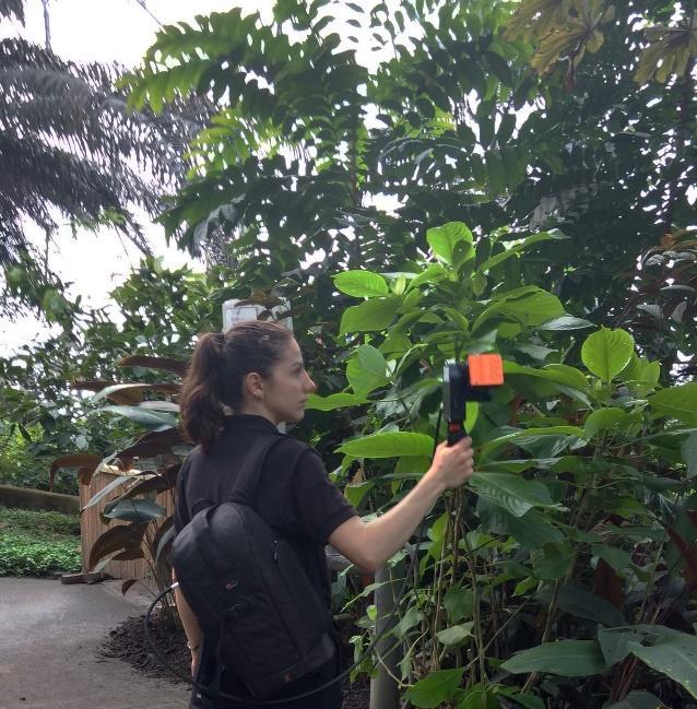
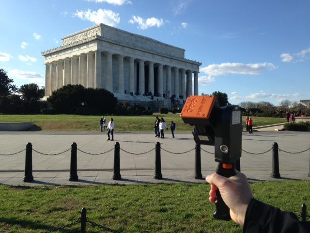
9 Introducing ZEB-REVO Fast complete whole surveys in minutes, not hours Simple to Use minimal training required Compact & Lightweight weighs only 4kg Rugged IP64 rated for outdoor & underground use Minimal data file sizes for faster processing

10 The ZEB-REVO Solution + ZEB-REVO Hardware GeoSLAM Hub Software 10


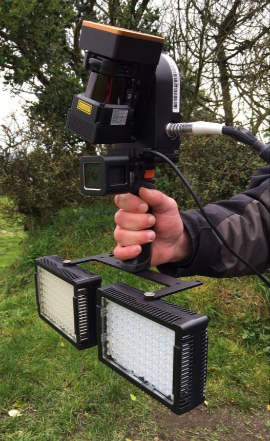
11 ZEB-REVO Hardware Laser Sensor Data Logger Inertial Measurement Unit Data Cable Battery Pack Geoslam.com 11
12 ZEB-REVO Specification Data Acquisition Speed Relative Accuracy Absolute Position Accuracy Maximum Range Laser Safety Class Angular Field of View IP Rating Scanner line speed 43,200 measurement points/second +/- 15mm Environment Dependent (Typically 3 30 cm) Up to 30m (15m outdoors) Class 1 Eye Safe 270 x 360 degrees IP64 (Dust tight, splash proof) 100 Hz Geoslam.com 12

13 The ZEB-REVO Workflow 3 simple steps WALK & SCAN REGISTER DATA POINT CLOUD 13

14 Introducing ZEB-REVO RT Realtime SLAM registration Graphical user interface SLAM quality feedback Halve your survey time by processing as you scan Ensure full coverage and view your data in the field Improve the accuracy of your data
 Hardware GeoSLAM Hub Software")
15 The ZEB-REVO RT Solution + ZEB-REVO RT (Real Time) Hardware GeoSLAM Hub Software 15
16 ZEB-REVO RT Specification Data Acquisition Speed Relative Accuracy Absolute Position Accuracy Maximum Range Laser Safety Class Angular Field of View Scanner line speed 43,200 measurement points/second +/- 15mm Environment Dependent (Typically 3 30 cm) Up to 30m (15m outdoors) Class 1 Eye Safe 270 x 360 degrees 100 Hz Geoslam.com 16


17 The ZEB-REVO RT Specification (Comparison with REVO) Feature ZEB-REVO ZEB-REVO RT SLAM registration Post Process Real Time Data Storage 55GB 120GB Wi-fi range NA 15m IP Rating IP64 IP51 ZEB-REVO Data logger Operating temp 0 to +50 degrees 10 to +30 degrees Operating Humidity <85% RH Avoid condensing humidty Battery Lithium Polymer Lithium Ion Battery Life 4 hours 1.5 hours Battery weight 600g 550g - Removable ZEB-REVO RT Data logger 17

18 The RT Workflow Process data as you walk and scan WALK, SCAN, REGISTER POINT CLOUD 18

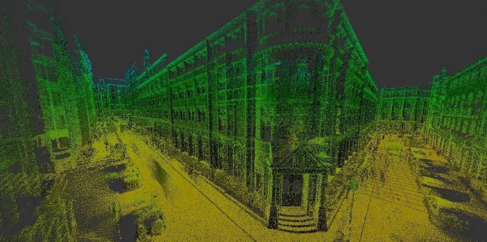
19 GeoSLAM Hub Software Main Features: Drag and drop local SLAM registration Dataset merging Convert 3D data to 2D layouts in GeoSLAM Draw Integrated 2D and 3D viewer User definable output formats User definable parameters for enhanced SLAM processing Ability to visualise synched imagery data captured from ZEB-CAM 19
20 GeoSLAM Hub Software Drag and drop processing Floorplan previews Easy to find datasets 20


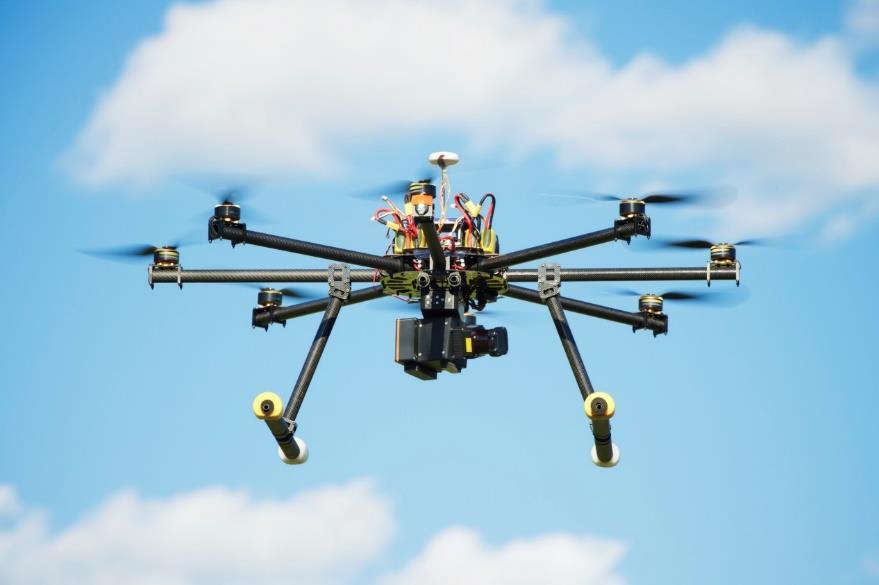
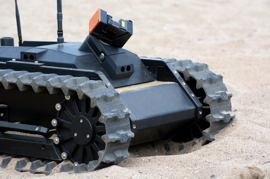
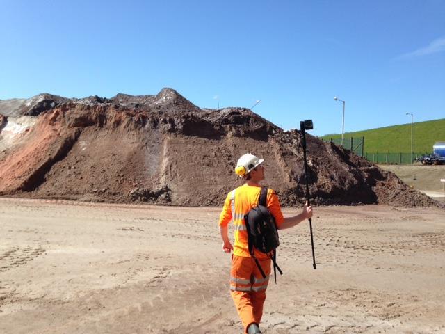
21 Hardware Accessories Versatility of Deployment ZEB Cradle (for vertical cable deployment) ZEB Backpack Frame Allows hands-free operation ZEB-CAM For imagery, context capture Spherical Targets Kit For referencing scan data 21


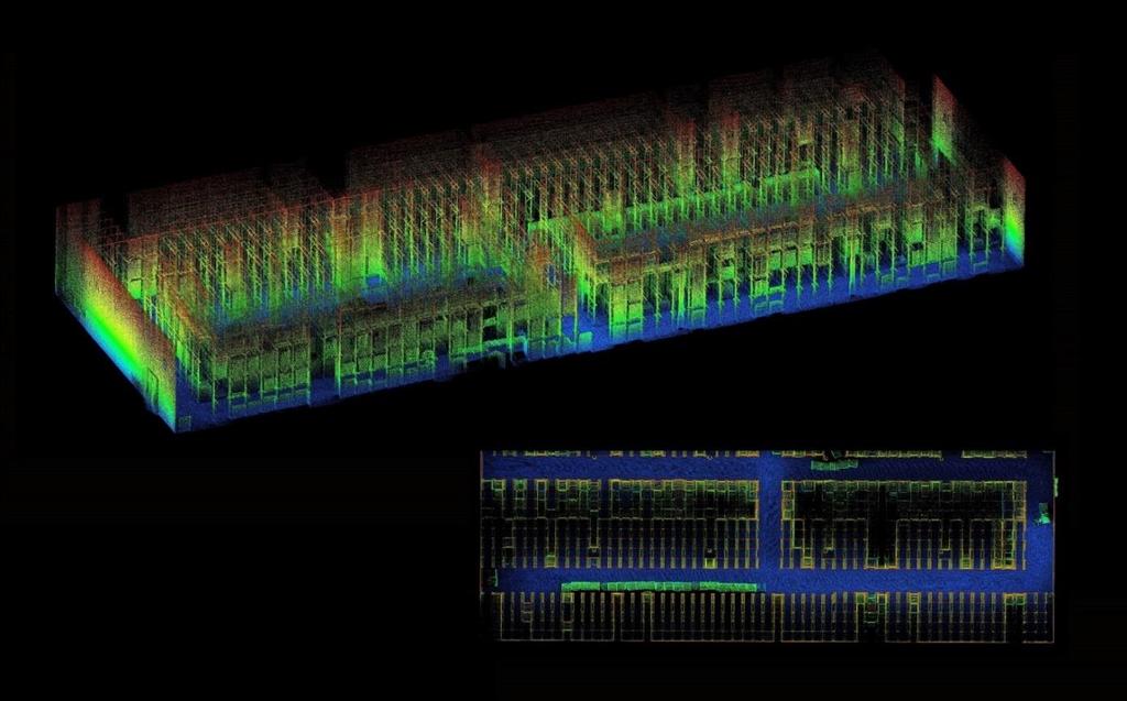
22 ZEB-CAM Adding Context to your Data Add-on camera unit to both ZEB-REVO & ZEB-REVO RT Adds contextual video & imagery information to 3D scan data Optical flow technology accurately synchronises video and scan data together Camera imagery can also be used in Bentley ContextCapture for colourisation Imagery data is processed and viewed in GeoSLAM Hub software using GeoSLAM View 22

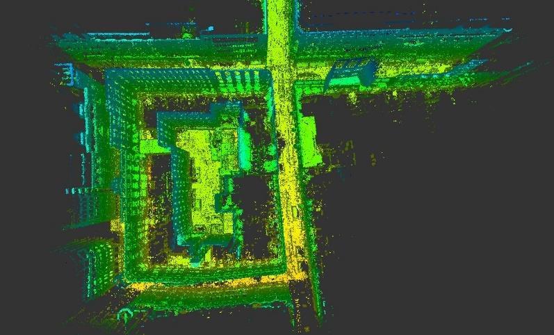
23 ZEB-CAM Imagery viewed in GeoSLAM Hub 3D view of scan data Thumbnail view of visual data, synchronised with scan data Trajectory of scanner journey Contextual imagery 23


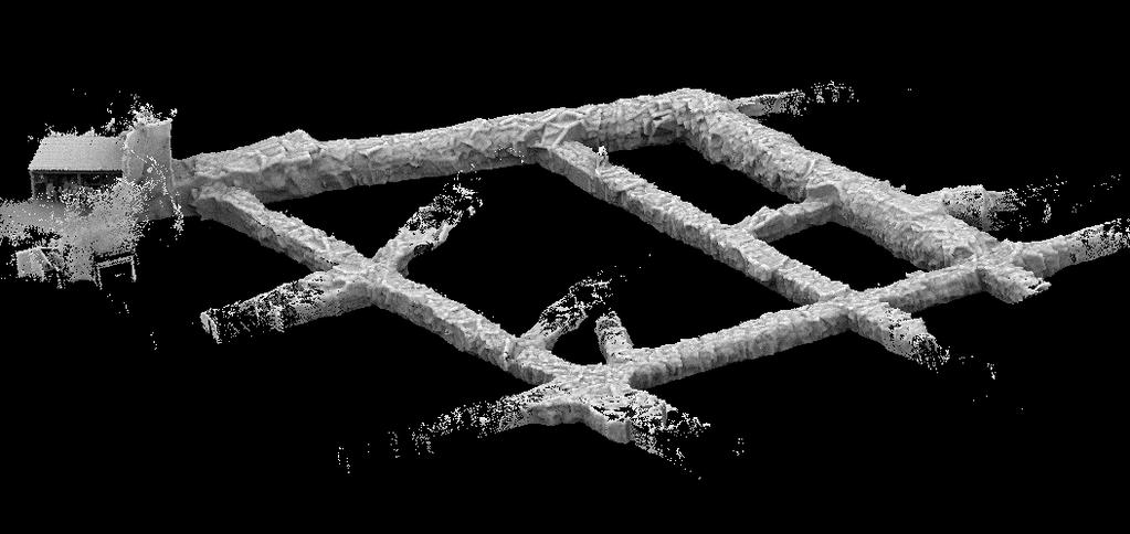
24 Versatile Deployment Options 24


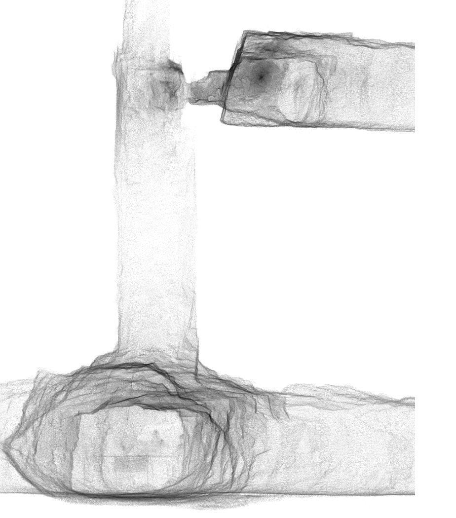
25 The Applications 25


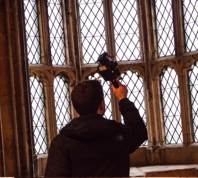
26 The Applications Used in multiple applications across 5 broad industries: Surveying Engineering Forestry Facilities & Asset Management Mining 26

27 Measured Building Surveys Commercial Geoslam.com 27


28 Measured Building Surveys Oriel College, Oxford University, UK The entire project was completed in around half of the total time that would have been required using static equipment. The ZEB-REVO is a real game-changer for us David Johnson Director Midland Survey Geoslam.com 28


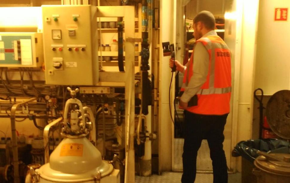
29 Measured Building Surveys Private Residential Geoslam.com 29


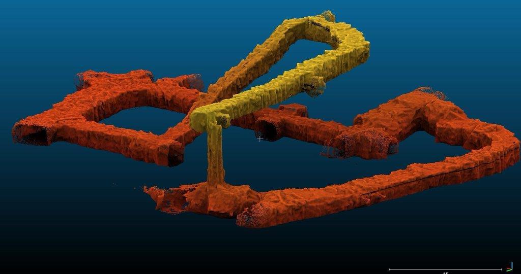
30 Scan to BIM Attucks School, Kansas, USA A BIM model was provided 2 weeks earlier than expected providing a comprehensive picture of the asset BHC Rhodes Geoslam.com 30

31 3D GIS Geoslam.com 31


32 Construction Progress Monitoring Office Block, UK This was the first time we used this type of scanner and we were able to complete the whole structure in approximately one hour Andy Ewen Manager of Survey BAM Geoslam.com 32


33 Infrastructure Inspection Britannia Bridge, Wales, UK With an average accuracy level of +/-15mm, the challenge of such a narrow structure did not limit the ZEB-REVO s effectiveness Geoslam.com 33


34 Heritage Surveys Medieval Barn, UK Geoslam.com 34


35 Large Area Mapping Mumbai slum, India Geoslam.com 35

36 Restricted Access Surveys Geoslam.com 36

37 Industrial & Mechanical Geoslam.com 37
38 Underground Mapping Geoslam.com 38


39 Underground Mapping Beck Engineering, Australia Geoslam.com 39


40 Stockpile Surveys Geoslam.com 40


41 Forestry The Eden Project, UK Forestry resource management Tree counting and mapping Biomass removal monitoring Geoslam.com 41
42 Strategic Partnerships 42


43 Indoor Reality Meshing Utilising ZEB-CAM Imagery GeoSLAM hardware + Bentley ContextCapture software allows the creation of indoor, full-colour reality meshes The resulting product is an engineering-grade textured 3D model for design, construction and analysis in the construction, engineering and facilities management sectors 43

44 Construction Verification Utilising GeoSLAM data Rapid and accurate data collection via ZEB-REVO or ZEB-REVO RT Scan data overlaid & compared with BIM model data inside Verity software Clash detection and errors quickly identified enabling fast resolution before construction problems mount 44


45 Global Customer Base Geoslam.com 45
46 In Summary go-anywhere 3D mobile mapping technology for indoor and outdoor mapping GeoSLAM hardware is fast, simple to use, and highly versatile for a wide range of applications GeoSLAM software is robust and proven in challenging environments over 1000 s of projects Established brand with a global network of support and distribution Large customer base already saving time and money 46
47 Find Out More Tel: +44 (0) Web: The experts in go anywhere 3D mobile mapping technology
GeoSLAM Overview. The experts in go-anywhere 3D mobile mapping technology
 GeoSLAM Overview The experts in go-anywhere 3D mobile mapping technology 1 About GeoSLAM The experts in go-anywhere 3D mobile mapping technology 2 Who We Are GeoSLAM is a global market leader in go-anywhere
HANDHELD MOBILE MAPPING / 3D LASER MAPPING SOLUTIONS. ZEB Family Brochure. geoslam.com
 HANDHELD MOBILE MAPPING / 3D LASER MAPPING SOLUTIONS ZEB Family Brochure geoslam.com NEW Long range, greater intensity, UAV ready HANDHELD BACKPACK UAV Effortless Data Capture Your tool to capture, view
GeoSLAM Overview. The global leader in go anywhere 3D mobile mapping technology. 1
 GeoSLAM Overview The global leader in go anywhere 3D mobile mapping technology. 1 About GeoSLAM The global leader in go anywhere 3D mobile mapping technology. 2 Who We Are GeoSLAM is a global market leader
Don t Listen To Us Listen To Our Customers
 Don t Listen To Us Listen To Our Customers GeoSLAM.com The experts in go-anywhere 3D mobile mapping technology Architects, engineers, facility managers, surveyors they are all seeking ways to be more profitable,
GeoSLAM Software. The complete end-to-end solution for GeoSLAM data. GeoSLAM.com
 GeoSLAM Software The complete end-to-end solution for GeoSLAM data GeoSLAM.com GeoSLAM Software Solutions GeoSLAM Hub & Draw is a comprehensive software suite that transforms 3D point cloud data into actionable
GeoSLAM Hub The complete software solution for GeoSLAM data
 GeoSLAM Hub The complete software solution for GeoSLAM data GeoSLAM.com GeoSLAM Hub A comprehensive software suite that turns GeoSLAM data into actionable information and valuable deliverables. A part
3D Laser Scanning Technology. Fast, Safe, Accurate. Rugged hardware and powerful software combined with streamlined survey workflow
 3D Laser Scanning Technology Fast, Safe, Accurate Rugged hardware and powerful software combined with streamlined survey workflow Maptek specialises in the research, development and application of 3D laser
Simplicity is the new black: The BLK360 story
 Simplicity is the new black: The BLK360 story Vanda KADLECIKOVA Leica Geosystems Heerbrugg, Switzerland E-mail: vanda.kadlecikova@leica-geosystems.com Abstract Meet the game changer. The new Leica BLK360
2/19/2018. Who are we? Who am I? What is Scanning? How does scanning work? How does scanning work? Scanning for Today s Surveyors
 2/19/2018 Who are we? Scanning for Today s Surveyors Survey, GIS, and Construction dealer Founded in 1988 Employee Owned Headquartered in Bismarck, ND States covered: ND, SD, MN, MT, WY, CO, UT, ID, WA,
Copyright ZEB-CAM User Guide 2018 GeoSLAM Ltd. All rights reserved.
 GeoSLAM ZEB-CAM UserGuide GeoSLAM.com Copyright ZEB-CAM User Guide 2018 GeoSLAM Ltd. All rights reserved. 2018 GeoSLAM Ltd 1 ZEB-CAM User Guide v3.0.0 CONTENTS Introduction... 5 1.1 Specification... 5
GeoSLAM Customer Case Studies a range of projects from around the world
 GeoSLAM Customer Case Studies a range of projects from around the world GeoSLAM.com GeoSLAM The experts in goanywhere 3D mobile mapping technology Architects, engineers, facility managers, surveyors they
UAVs & IMAGES ACCESSORIES ABOUT GEXCEL
 LIDAR SOFTWARE UAVs & IMAGES MONITORING MOBILE MAPPING ACCESSORIES OTHER ABOUT GEXCEL BUSINESS TEAM LOCATIONS Gexcel offices are located in Italy in two Innovation Centers SALES NETWORK Gexcel s worldwide
The Most Comprehensive Solution for Indoor Mapping Applications
 The Most Comprehensive Solution for Indoor Mapping Applications TRIMBLE INDOOR MOBILE MAPPING SOLUTION TRIMBLE INDOOR MOBILE MAPPING SOLUTION (TIMMS): HIGH EFFICIENCY, MAXIMUM FLEXIBILITY, ALL-IN-ONE PACKAGE
SPS ZOOM D Laser Scanner SPS ZOOM 300
 3D Laser Scanner 3D Laser Scanner A 3D laser scanner is a device that collects precise spatial data of objects or environments. The collected point cloud data can then be used to construct digital three
Hardware 3D Mapping Systems
 Hardware 3D Mapping Systems About Us GreenValley International GreenValley International provides 3D mapping solutions that include mobile & aerial LiDAR acquisition hardware, post-processing software
Copyright ZEB CAM User s Manual 2016 GeoSLAM Ltd. All rights reserved.
 Copyright ZEB CAM User s Manual 2016 GeoSLAM Ltd. All rights reserved. 2016 GeoSLAM Ltd 1 ZEB CAM User s Manual v1.0.0 2016 GeoSLAM Ltd 2 ZEB CAM User s Manual v1.0.0 CONTENTS Introduction... 5 1.1 Specification...
Copyright GeoSLAM Viewer User Guide 2017 GeoSLAM Ltd. All rights reserved. Version GeoSLAM Ltd 1 GeoSLAM Viewer User Guide v1.0.
 Copyright GeoSLAM Viewer User Guide 2017 GeoSLAM Ltd. All rights reserved. Version 1.0.0 2017 GeoSLAM Ltd 1 GeoSLAM Viewer User Guide v1.0.0 2017 GeoSLAM Ltd 2 GeoSLAM Viewer User Guide v1.0.0 CONTENTS
Iwane Mobile Mapping System
 Iwane Mobile Mapping System Geo-Imaging Mobile Mapping Solution Iwane Mobile Mapping System (IMMS) is high-efficient, easyto-use, end-to-end solution that provides tremendous flexibility in collecting,
3D Laser Scanning Technology. Rugged hardware and powerful software combined with streamlined survey workflow
 3D Laser Scanning Technology Rugged hardware and powerful software combined with streamlined survey workflow I-Site XR3 laser scanner The Maptek I-Site XR3 laser scanner represents the latest laser imaging
3D Laser Scanner. Fast, Portable, Accurate. Long range laser scanner Modular design configured to suit your survey needs
 3D Laser Scanner Fast, Portable, Accurate Long range laser scanner Modular design configured to suit your survey needs Introducing the Maptek I-Site 8820 laser scanner The Maptek I-Site 8820 laser scanner
New trends of GIS terrain mapping with modern low cost GNSS technology
 New trends of GIS terrain mapping with modern low cost GNSS technology Tomáš Bláha / Magellan Professional Sales Manager Eastern Europe DATECS GIS Conference, March 27, 2009, Sofia Hotel Holiday Inn 1
Leica Zeno 20 More than GPS
 Leica Zeno 20 More than GPS TECHNOLOGIES Leica Zeno 20 does so much more The Leica Zeno 20 is much more than just GPS it is a fusion of great technologies. Powerful and easy, it s the ultimate geospatial
Trimble MX2 mobile mapping
 Trimble MX2 mobile mapping user applications Point clouds within your reach The Trimble MX2 is a vehicle-mounted spatial imaging system which combines high resolution laser scanning and panoramic cameras
KRISTAPS KLAVA - HEAD OF LASER SCANNING DEPARTMENT AT MERKO 3D LASER SCANNING POSSIBILITIES IN REAL ESTATE
 KRISTAPS KLAVA - HEAD OF LASER SCANNING DEPARTMENT AT MERKO 3D LASER SCANNING POSSIBILITIES IN REAL ESTATE Overview 1. What is laser scanning; 2. Technology; 3. End results of laser scanning; 4. Applications;
Overview of the Trimble TX5 Laser Scanner
 Overview of the Trimble TX5 Laser Scanner Trimble TX5 Revolutionary and versatile scanning solution Compact / Lightweight Efficient Economical Ease of Use Small and Compact Smallest and most compact 3D
NEW APPROACH FOR SAFE, FAST AND ACCURATE SURVEY OF DEEP MINE SHAFTS
 NEW APPROACH FOR SAFE, FAST AND ACCURATE SURVEY OF DEEP MINE SHAFTS by Norbert Benecke & Peter Cain DMT GmbH &Co. KG, Germany / DMT Geosciences, Canada Kinemattic Shaft Survey 2013 Page 1 Who is DMT? is
Leica Pegasus: Backpack
 Leica Pegasus: Backpack Fast Acquisition Accurate data Indoor/Outdoor projects Pegasus:Backpack Simple workflow Everything, Everywhere 1 Leica Pegasus: Backpack Award Winning System Remarks Multiple Award
3D Industrial plants. Documentation
 3D Industrial plants Documentation Published by: FARO Europe GmbH & Co. KG, Lingwiesenstrasse 11/2, D-70825 Korntal-Münchingen, Tel: +49 7150 9797-0, Fax: +49 7150 9797-44, info@faroeurope.com, www.faro.com
COLLABORATION is KEY
 AN AERIAL ADVANTAGE COLLABORATION is KEY LIVING AND WORKING IN A WORLD OF FAST TECHNOLOGICAL ADVANCEMENT, COLLABORATION OF SKILLS IS BECOMING MORE COMMONPLACE. DTM Technologies Ltd and Seahawk AP have
OPEN. INTELLIGENT. Laser Scanning Software Solutions
 OPEN. INTELLIGENT. Laser Scanning Software Solutions www.lfm-software.com The Future of Laser Scanning Safe and efficient operation of complex engineering assets, and the efficient management of their
Reality Modeling Webinar
 Reality Modeling Webinar Leveraging 3D Reality Meshes for Real-Time Asset Management and Monitoring What is Reality Modeling? Images & video? What is Reality Modeling? Images & video As-built drawings
DATASHEET Pepwave Mesh Connector
 Features Vendor Neutral Repeater, Interoperability Certified The allows you to seamlessly extend the coverage of an existing Wi-Fi network, without messy configurations or having to run cables! Simply
InteLAS Family of Mobile LiDAR Systems
 InteLAS Family of Mobile LiDAR Systems September 2015 What we do ilinks Geosolutions LLC Hydrographic surveying and seabed modeling Topographic surveying and mobile mapping Systems engineering and integration
Comparative study on the differences between the mobile mapping backpack systems ROBIN- 3D Laser Mapping, and Pegasus- Leica Geosystems.
 3 th Bachelor Real Estate, Land Surveying Measuring Methods III Comparative study on the differences between the mobile mapping backpack systems ROBIN- 3D Laser Mapping, and Pegasus- Leica Geosystems.
Geospatial Engineering Problems & Solutions Associated With NDP Roads, Tunnelling & Civil Engineering Projects Use of HDS Leica Laser Scanners
 Geospatial Engineering Problems & Solutions Associated With NDP Roads, Tunnelling & Civil Engineering Projects Use of HDS Leica Laser Scanners Laser Scanning Laser Scanning is a method of collecting large
ROAD-SCANNER COMPACT APPLICATION FIELDS MAIN FEATURES
 ROAD-SCANNER COMPACT Mobile Mapping System by GEXCEL & SITECO collaboration A smaller mobile system for asset management and cartography suited for ZOLLER & FRÖHLICH PROFILER 9012 laser scanner. 2 + 3
ADVANCING REALITY MODELING WITH CONTEXTCAPTURE
 ADVANCING REALITY MODELING WITH CONTEXTCAPTURE Knowing the existing conditions of a project is a key asset in any decision process. Governments need to better know their territories, through mapping operations,
JANUARY 2017 WATER S END. Mobile Mapping. Station to Station. Decided Guidance Indoor application. Implementing BIM. A fixed boundary R E YEARS
 JANUARY 2017 WATER S END Mobile Mapping Station to Station Decided Guidance Indoor application Implementing BIM A fixed boundary R LEB ATING E C 30 YEARS Indoor Mobile Mapping A unique approach to interior
Rugged Computing Range
 Rugged Computing Range A leader in the global ICT Industry, MiTAC International Corp. was founded in 1982, and designs and manufactures awardwinning technology products for the automotive, enterprise,
Gas detection just got personal
 Gas detection just got personal Part of the ersonal urveyor range Coloured 'rubber boot' for multi-site or multi-application working (7 colours available) Simple 1-button operation Any combination of (LEL/O
Copyright ZEB-REVO RT User s Manual 2018 GeoSLAM Ltd. All rights reserved.
 Copyright ZEB-REVO RT User s Manual 2018 GeoSLAM Ltd. All rights reserved. 2018 GeoSLAM Ltd 1 ZEB-REVO RT User s Manual v1.0.3 2018 GeoSLAM Ltd 2 ZEB-REVO RT User s Manual v1.0.3 CONTENTS Introduction...
Using SLAM-based Handheld Laser Scanning to Gain Information on Difficult-to-access Areas for Use in Maintenance Model
 Using SLAM-based Handheld Laser Scanning to Gain Information on Difficult-to-access Areas for Use in Maintenance Model T. Makkonen a, R. Heikkilä a, P. Tölli b, F. Fedorik a a Construction Technology Research
Jeffrey A. Schepers P.S. EIT Geospatial Services Holland Engineering Inc. 220 Hoover Blvd, Suite 2, Holland, MI Desk
 Jeffrey A. Schepers P.S. EIT Geospatial Services Holland Engineering Inc. 220 Hoover Blvd, Suite 2, Holland, MI 49423 616-594-5127 Desk 616-322-1724 Cell 616-392-5938 Office Mobile LiDAR - Laser Scanning
BIM & Digital Transformation Scotland Live 2018 Capturing 3D Reality at the push of a button
 BIM & Digital Transformation Scotland Live 2018 Capturing 3D Reality at the push of a button Gary Kelly Country Manager Scotland Leica Geosystems @LeicaScot Capturing 3D Reality at the push of a button
Trimble Indoor Mobile Mapping Solution
 Kevin Perkins Applanix Corp. NATIONAL SURVEYING, MAPPING & GEOSPATIAL CONFERENCE - MARCH 13-17, 2017 Trimble Indoor Mobile Mapping Solution Why Indoor Mapping? The need: As-built maps/models of indoor
RealWorld RealCity RealTerrain Airborne Reality Capture The Integral World of Leica Airborne Solutions
 RealWorld RealCity RealTerrain Airborne Reality Capture The Integral World of Leica Airborne Solutions Photogrammetric Week, September 11, 2017 Dr. Hartmut Rosengarten, Director Airborne Solutions EMEA,
3D ponttechnológia használata napjainkban október. 10. Tatabány, Mérnöki továbbképzés Zeke Zsolt Mérnök üzletkötő
 3D ponttechnológia használata napjainkban 2018. október. 10. Tatabány, Mérnöki továbbképzés Zeke Zsolt Mérnök üzletkötő Leica BLK3D NEW based on photogrametry Leica HDS Termékportfólió BLK360 RTC360 P40/50
Rapid Building information modeling. Ivar Oveland 2013
 Rapid Building information modeling Ivar Oveland 2013 Case study How can I rapidly create a building information model? Today: Different methods are used today to establish a building information model
Terrain Modeling and Mapping for Telecom Network Installation Using Scanning Technology. Maziana Muhamad
 Terrain Modeling and Mapping for Telecom Network Installation Using Scanning Technology Maziana Muhamad Summarising LiDAR (Airborne Laser Scanning) LiDAR is a reliable survey technique, capable of: acquiring
BIM for infrastructure make easy with Laser Scanner. 17 October Beng Chieh Quah Head of Marketing Asia Pacific
 BIM for infrastructure make easy with Laser Scanner 17 October 2016 Beng Chieh Quah Head of Marketing Asia Pacific who is? founded in 1981 NASDAQ since 1997 Global technology company Offering a range of
QuickScan QM2400 / QBT2400
 QuickScan QM2400 / QBT2400 August 2014 QuickScan 2400 Series: 2D Cordless Value Proposition Price Leader Provide Customers an affordable migration solution to move from 1D Corded/Cordless to 2D Cordless
HP-L-8.9 LASER SCANNER
 PRODUCT BROCHURE HP-L-8.9 LASER SCANNER Cost-effective laser scanning for the ROMER Absolute Arm 2 HP-L-8.9 LASER SCANNER HIGHLIGHTS MAKING LASER SCANNING ACCESSIBLE TO ALL The HP-L-8.9 is an affordable
An Overview of Applanix.
 An Overview of Applanix The Company The Industry Leader in Developing Aided Inertial Technology Founded on Canadian Aerospace and Defense Industry Expertise Providing Precise Position and Orientation Systems
EinScan-Pro vs. EinScan-Pro+
 China s first OTC company in the 3D digitizing and printing industry(830978) EinScan-Pro vs. EinScan-Pro+ Copyright 2015-2016 Shining 3D. All rights reserved. Version: November 2017 EinScan-Pro & Pro+
Shaping the World with Leica Zeno GIS Asset Collection & Management
 Shaping the World with Leica Zeno GIS Asset Collection & Management Edward Toh GIS Segment Manager, APAC Agenda Power of Geography Location bring values Case Studies Integration of Surveyors into GIS Leica
UltraTEV Plus 2 Make Partial Discharge discovery simple.
 UltraTEV Plus 2 Make Partial Discharge discovery simple www.eatechnology.com The UltraTEV TM Plus 2 brings together techniques and a wealth of experience and insight to make it easier than ever to avoid
Real world data collecting tools. Company Introduction. C2L equipment.co,.ltd
 Company Introduction C2L equipment.co,.ltd www.c2l-equipment.com Company Status Business Areas Company name C2L equipment.co,.ltd Address CEO Unit 603, Samwhan HIPEX B, Pangyo Station RD 230, Bundang,
StreetMapper 360 & StreetMapper Portable
 StreetMapper 360 & StreetMapper Portable 11th February 2010 Dr. Chris Cox & Mr. Olaf Gross 3D Laser Mapping LIDAR Specialists StreetMapper Distributor for RIEGL (UK, Ireland, Southern Africa) Terrasolid
Leica Absolute Trackers
 PRODUCT BROCHURE Leica Absolute Trackers Probing Solutions Leica Absolute Tracker AT402 and B-Probe ENTRY-LEVEL ULTRA-PORTABLE Probing System The Leica B-Probe is a handheld and battery-powered point probing
Wireless Data Logger System
 RTR-57U Wireless Data Logger System Collect, Manage and Monitor Your Valuable Data via Wireless Communication USB ion With sensor adaptor connected RS-232C ion to Computer to Network Image created for
ROAD SURFACE STRUCTURE MONITORING AND ANALYSIS USING HIGH PRECISION GPS MOBILE MEASUREMENT SYSTEMS (MMS)
") ROAD SURFACE STRUCTURE MONITORING AND ANALYSIS USING HIGH PRECISION GPS MOBILE MEASUREMENT SYSTEMS (MMS) Bonifacio R. Prieto PASCO Philippines Corporation, Pasig City, 1605, Philippines Email: bonifacio_prieto@pascoph.com
ROAD SURFACE STRUCTURE MONITORING AND ANALYSIS USING HIGH PRECISION GPS MOBILE MEASUREMENT SYSTEMS (MMS) Bonifacio R. Prieto PASCO Philippines Corporation, Pasig City, 1605, Philippines Email: bonifacio_prieto@pascoph.com
Aided-inertial for GPS-denied Navigation and Mapping
 Aided-inertial for GPS-denied Navigation and Mapping Erik Lithopoulos Applanix Corporation 85 Leek Crescent, Richmond Ontario, Canada L4B 3B3 elithopoulos@applanix.com ABSTRACT This paper describes the
Bringing Singapore to life in 3D
 Bringing Singapore to life in 3D Dr Victor Khoo, Deputy Director Singapore Land Authority Bringing Singapore to life in 3D ESRI Singapore UC 2016 Dr. Victor Khoo Singapore Land Authority SLA 2016 RESTRICTED
See more with the NEW testo 880 thermal imager
 Committing to the future See more with the NEW testo 880 thermal imager NEW! SEE MORE......OFFER MORE. Infrared radiation cannot be seen by the human eye. All objects whose temperature is above absolute
Comparing Aerial Photogrammetry and 3D Laser Scanning Methods for Creating 3D Models of Complex Objects
 Comparing Aerial Photogrammetry and 3D Laser Scanning Methods for Creating 3D Models of Complex Objects A Bentley Systems White Paper Cyril Novel Senior Software Engineer, Bentley Systems Renaud Keriven
WIRELESS CCTV. Mobile Surveillance for Events.
 WIRELESS CCTV Mobile Surveillance for Events Wireless CCTV Wireless CCTV (WCCTV) is a market leading, customer focussed provider of portable, re-deployable mobile surveillance solutions. WCCTV manufactures
ET50/55 THE ENTERPRISE TABLET Built for Business
 Lightning Talk ET50/55 THE ENTERPRISE TABLET Built for Business Kevin Lollock NA RPM OS, Software and Developer Platforms THE ET50/55 - CONSUMER STYLING ON THE OUTSIDE. ALL BUSINESS ON THE INSIDE. The
TIMMS : FAST, ACCURATE & COST-EFFECTIVE INDOOR MAPPING
 TIMMS : FAST, ACCURATE & COST-EFFECTIVE INDOOR MAPPING Designed for ease-of-use and maneuverability, TIMMS is a high-productivity tool for accurately measuring, georeferencing and modeling interior spaces
Integrated Field to Finish BIM for Surveyors. Boris Skopljak Market Manager, Trimble Geospatial Office Software
 Integrated Field to Finish BIM for Surveyors Boris Skopljak (boris_skopljak@trimble.com) Market Manager, Trimble Geospatial Office Software Agenda Trimble Introduction BIM relevance in Trimble Trimble
Storage Tank Solutions TRANSFORMING THE WAY THE WORLD WORKS
 Storage Tank Solutions Trimble TX8 Scanner: A Revolution in 3D Scanning TRUE PERFORMANCE IN A REAL WORLD The Trimble TX8 laser scanner sets new standards for performance and ease of use in high-speed collection
IP-S2 HD HD IP-S2. 3D Mobile Mapping System. 3D Mobile Mapping System
 HD HD 3D Mobile Mapping System 3D Mobile Mapping System Capture Geo-referenced, Time-Stamped Point Clouds and Imagery 3D Scanning of Roadside Features 360º Camera for Spherical Image Capture Dual Frequency
PRODUCT BROCHURE SCANNING SOLUTIONS PORTABLE LASER SCANNING WITH THE LEICA ABSOLUTE TRACKER
 PRODUCT BROCHURE SCANNING SOLUTIONS PORTABLE LASER SCANNING WITH THE LEICA ABSOLUTE TRACKER INTRODUCTION THE RIGHT SOLUTION FOR EVERY SCANNING APPLICATION Hexagon Manufacturing Intelligence s portable
3D Laser Scanner VS1000 User Manual
 3D Laser Scanner VS1000 User Manual 1 VS1000 Introduction SMART MAX GEOSYSTEMS CO., LTD VS1000 3D Laser Scanner based on pulses ranging principle, could quick acquire massive point cloud data from the
BLAZE 600M HIGH-ACCURACY BLUE LIGHT MEASUREMENT SYSTEM PRODUCT BROCHURE
 BLAZE 600M HIGH-ACCURACY BLUE LIGHT MEASUREMENT SYSTEM PRODUCT BROCHURE BLAZING SPEED, DAZZLING PERFORMANCE The BLAZE 600M portable blue light measurement system from Hexagon Manufacturing Intelligence
Trimble UAS Portfolio Update. August 25 th 2015
 Trimble UAS Portfolio Update August 25 th 2015 Trimble UAS Portfolio Updates Trimble UX5 Setting the Standard in Mapping Trimble UX5 HP High Precision Surveying and Mapping Solution Trimble ZX5 Flexible
BIM PROCESS COMPARING NEW BUILD WITH EXISTING ASSETS A VERY QUICK SUMMARY OF THE PROCESS
 : STEPPING INTO THE FUTURE WITH THE PAST HYBRID MODELLING IN THE BIM PROCESS CARL BROOKES 8 DECEMBER 2017 INTRODUCTION Very quick summary of BIM process Comparing New build with existing assets 3D model
Integrated Multi-Source LiDAR and Imagery
 Figure 1: AirDaC aerial scanning system Integrated Multi-Source LiDAR and Imagery The derived benefits of LiDAR scanning in the fields of engineering, surveying, and planning are well documented. It has
Servosila Robotic Heads
 Servosila Robotic Heads www.servosila.com TABLE OF CONTENTS SERVOSILA ROBOTIC HEADS 2 SOFTWARE-DEFINED FUNCTIONS OF THE ROBOTIC HEADS 2 SPECIFICATIONS: ROBOTIC HEADS 4 DIMENSIONS OF ROBOTIC HEAD 5 DIMENSIONS
Trimble GeoSpatial Products
 Expanding Solutions for Photogrammetric and Remote Sensing Professionals 55 th Photogrammetric Week in Stuttgart September 7 th 2015 Tobias Heuchel, Trimble Stuttgart, Germany Trimble GeoSpatial Products
WIRELESS ENVIRONMENTAL MONITORS
 Packet Powers compact wireless Environmental Monitors makes it easy and affordable to monitor all environmental conditions in your facility. From installation to monitoring in minutes 1 Place wireless
wi4 Fixed Point-to-Multipoint Canopy Solutions
 wi4 Fixed Point-to-Multipoint Canopy Solutions Canopy Technology is as Simple as it is Powerful The wi4 Fixed Point-to-Multipoint Canopy solution is streamlined, powerful and simple, with built-in installation
EMPOWERING YOUR DIGITAL OILFIELD
 EMPOWERING YOUR DIGITAL OILFIELD FOR CUSTOMER CARE QUERIES, PLEASE WRITE TO THE CUSTOMER CARE CENTER: CUSTOMER.CARE@THURAYA.COM DIAL 100 FROM A THURAYA PHONE, OR +88216 100 100 FROM OTHER NETWORKS. YOU
Comparing Aerial Photogrammetry and 3D Laser Scanning Methods for Creating 3D Models of Complex Objects
 www.bentley.com Comparing Aerial Photogrammetry and 3D Laser Scanning Methods for Creating 3D Models of Complex Objects A Bentley White Paper Cyril Novel Senior Software Engineer, Bentley Systems Renaud
BE INSPIRED.
 BE INSPIRED www.scaninabox.com Last update October 2017 PROFESSIONALISM, OUR CORE Accurately manufactured in every detail, Scan in a Box FX offers high quality 3D Scans. The Made in Italy design has been
RobotEye RE05 3D LIDAR 3D Laser Scanning System. Product Datasheet
 3 D L A S E R S C A N N I N G S Y S T E M S RobotEye RE05 3D LIDAR 3D Laser Scanning System Product Datasheet 2014 Ocular Robotics Ltd All rights reserved RobotEye RE05 3D LIDAR - 3D Laser Scanning System
imagine having the measure of an entire city
 imagine having the measure of an entire city SAMSUNG recommends Windows XP Tablet PC Edition. imagine mobilising your cad system Like all great partnerships, PowerCAD SiteMaster software and the Samsung
2/9/2016. Session Agenda: Implementing new Geospatial Technologies for more efficient data capture
 Implementing new Geospatial Technologies for more efficient data capture Jay Haskamp Applied Geospatial Engineer Steve Richter VP Sales Session Agenda: Today s changing technologies and what lies ahead
Virtual and remote inspection methods
 Virtual and remote inspection methods Rasmus Lindeneg Johansen, RLJ@cowi.dk 1 How do we inspect "today"? 2 Inspection "today" Manual inspections From the ground From lift/platform By rope Data was collected
Trimble Update. BIMnet 17 th June 2013 BUILDING CONSTRUCTION
 Trimble Update BIMnet 17 th June 2013 BUILDING CONSTRUCTION Agenda Introduction to Trimble What is Trimble BIM+Build? The benefits of BIM to Field Questions? 2 Trimble corporate roots Founded in 1978 Market
The Trimble 3D Scanning Solution: Designed by Surveyors for Surveyors
 The Trimble 3D Scanning Solution: Designed by Surveyors for Surveyors TRIMBLE 3D SCANNING Designed by surveyors for surveyors, the Trimble 3D scanning solution follows the surveying workflow you re familiar
GEOGRAPHIC INFORMATION SYSTEMS (GIS)
") GEOGRAPHIC INFORMATION SYSTEMS (GIS) MobileMaper 120 MobileMaper 10 A Geographic Information System (GIS) is a system designed to capture, store, manipulate, analyze, manage, and present geographic data
GEOGRAPHIC INFORMATION SYSTEMS (GIS) MobileMaper 120 MobileMaper 10 A Geographic Information System (GIS) is a system designed to capture, store, manipulate, analyze, manage, and present geographic data
VERSATILE AND EASY-TO-USE 3D LASER SCANNERS
 VERSATILE AND EASY-TO-USE 3D LASER SCANNERS > > A WORLD OF APPLICATIONS Z Corporation, producers of the industry s fastest, easiest-to-use and most versatile 3D scanners, makes 3D scanning ideal for a
Trimble Mobile Mapping Portfolio
 Jörg Amend Sales Account Manager SEPTEMBER 20 2017 Trimble Mobile Mapping Portfolio Current challenges and trends Multible Sensors connecting to one Echosystem Trimble RealWorks Trimble Edgewise TBC Pathfinder
Technical Masterclass: Making the Most of Point Cloud ReCap 360 Pro
 Developed by Cadline Limited Page 1 of 8 Technical Masterclass: Making the Most of Point Cloud ReCap 360 Pro Presented by: Geoff Woodhead, Infrastructure Specialist Page 2 of 8 Making the Most of Point
Thermal cameras. Detect hot spots before they cause you trouble
 Thermal cameras Detect hot spots before they cause you trouble Thermal imaging Detect hot spots before they cause you trouble Using an SKF Thermal camera is a proactive way to help you detect problems
Leica High-Definition Surveying Systems. Leica HDS3000. The Industry Standard for High-Definition Surveying
 Leica High-Definition Surveying Systems Leica HDS3000 The Industry Standard for High-Definition Surveying HDS High-Definition Surveying TM : Laser Scanning Redefined High-Definition Surveying, or HDS,
The Leica HDS Family. The Right Tool for the Job HDS3000 HDS2500 HDS4500. Cyclone & CloudWorx. Press the QuickScan button to define the field-of-view.
 HDS2500 High accuracy scanner, ideal for fixed or raised installations when leveled tripod mounting is not practical, or areas with less stringent field-of-view requirements. The Leica HDS Family Time-of-flight
SPAR, ELMF 2013, Amsterdam. Laser Scanning on the UK Highways Agency Network. Hamish Grierson Blom Uk
 SPAR, ELMF 2013, Amsterdam Laser Scanning on the UK Highways Agency Network Hamish Grierson Blom Uk www.blomasa.com www.blom-uk.co.uk Blom UK Part of the Blom Group Blom Group - Europe s largest aerial
Towards Optimal 3D Point Clouds
 By Andreas Nüchter, Jan Elseberg and Dorit Borrmann, Germany feature Automation in 3D Mobile Laser Scanning Towards Optimal 3D Point Clouds Motivated by the increasing need for rapid characterisation of
3D SCANNING SOLUTION FOR AIRCRAFT SURFACE INSPECTION
 NDT SOLUTIONS 3D SCANNING SOLUTION FOR AIRCRAFT SURFACE INSPECTION Maintenance, Repair & Overhaul (MRO) experts are facing added pressure to make sure that in-service aircraft are assessed carefully to