AUTOMATIC 3D RECONSTRUCTION OF BUILDINGS ROOF TOPS IN DENSELY URBANIZED AREAS
|
|
|
- Dana McCarthy
- 5 years ago
- Views:
Transcription


1 National Technical University Of Athens School of Rural and Surveying Engineering AUTOMATIC 3D RECONSTRUCTION OF BUILDINGS ROOF TOPS IN DENSELY URBANIZED AREAS Maria Gkeli, Surveying Engineer, PhD student Dr. Charalabos Ioannidis, Professor Gkeli, M., & Ioannidis, C., Automatic 3D Reconstruction of Buildings Roof Tops in Densely Urbanized Areas. In: 3D GeoInfo Conference, 1-2 October 2018,


2 Introduction v Main Purpose: Automatic 3D reconstruction of buildings roof tops in densely urbanized areas, utilizing dense point clouds v Current research trends: ü automatic extraction and reconstruction of 3D buildings ü digital image matching as alternative to airborne LiDAR v Applications: ü urban planning / 3D city modelling ü GIS ü tax assessment ü 2D/3D cadastre ü etc.
3 3D Reconstruction Model-driven parametric modeling 3D Reconstruction Approaches Hybrid Data-driven non-parametric modeling Attributed Building Grammars Shape Grammars Computer Generated Architecture Grammar etc. Plane Fitting Methods Filtering & Thresholding Methods Supervised Classification Methods Segmentation-based Methods Surface Reconstruction Algorithms Combinatorial algorithms Implicit functions Tetrahedralization etc. Marching Cubes Poisson Surface Reconstruction


4 Poisson Surface Reconstruction Algorithm ü Initial Data: Oriented point samples ü Main Phases: oriented point cloud à continuous vector field in 3D finding a scalar function whose gradients best match the vector field extraction of the appropriate Isosurface ü Advantages: resilient to noise resilient to misregistration artifacts ü Screened Poisson Surface Reconstruction
5 Proposed Methodology Overview Phase 1 Outliers and non-roof elements are detected and removed Phase 2 Buildings roof tops geometry optimization Phase 3 Partial Surface reconstruction of buildings roof tops
6 Proposed Methodology Overview Phase 1 Outliers and non-roof elements are detected and removed Phase 2 Buildings roof tops geometry optimization Statistical Outlier Removal (SOR) P* = {p*q є P (µk - α σk) d* (µk + α σk) } where P = initial point cloud P* = filtered point cloud µk = mean deviation σk = standard deviation α = desired density restrictiveness factor d = mean distance Phase 3 Partial Surface reconstruction of buildings roof tops
7 Proposed Methodology Overview Phase 1 Outliers and non-roof elements are detected and removed Statistical Outlier Removal (SOR) Moving Least Square (MLS) smoothing Phase 2 Buildings roof tops geometry optimization Phase 3 Partial Surface reconstruction of buildings roof tops
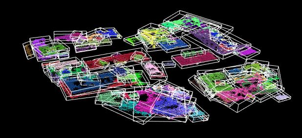
8 Proposed Methodology Overview Phase 1 Outliers and non-roof elements are detected and removed Phase 2 Buildings roof tops geometry optimization Phase 3 Partial Surface reconstruction of buildings roof tops Statistical Outlier Removal (SOR) Moving Least Square (MLS) smoothing Detection and Removal of non-roof objects Algorithmic process Bottoms-Up Segmentation of P per 3m q {q 1..q n } Euclidean distance clustering e {e 1..e n } є q (tolerance 1m) RANSAC plane fitting for each e (threshold 0.5m) Moments of Inertia Calculation - OBB (ratio OBB 4) Thresholds Area Calculation (area 10m 2 ) check
9 Proposed Methodology Overview Phase 1 Outliers and non-roof elements are detected and removed Phase 2 Buildings roof tops geometry optimization Edge Detection Differences of Normals (DoN) Phase 3 Partial Surface reconstruction of buildings roof tops Threshold value n 0.80
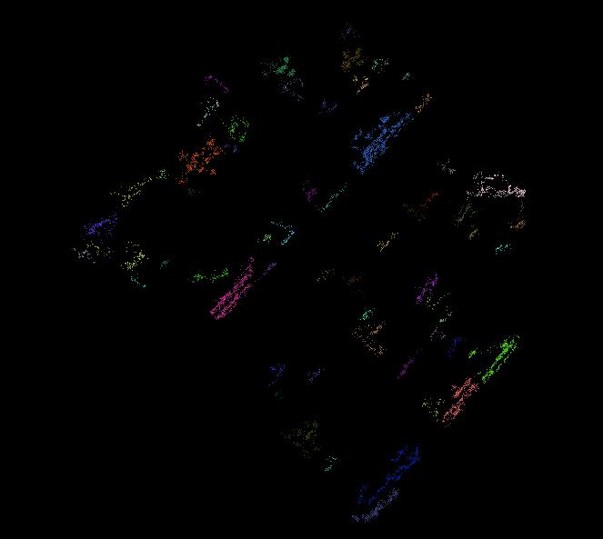
10 Proposed Methodology Overview Phase 1 Outliers and non-roof elements are detected and removed Phase 2 Buildings roof tops geometry optimization Edge Detection Edge Normalization RANSAC line fitting (threshold 0.5m) Phase 3 Partial Surface reconstruction of buildings roof tops
11 Proposed Methodology Overview Phase 1 Outliers and non-roof elements are detected and removed Phase 2 Buildings roof tops geometry optimization Phase 3 Partial Surface reconstruction of buildings roof tops Surface Reconstruction Algorithmic process Top-Bottom Segmentation of P per 1m q {q1..qn} Euclidean distance clustering e {e1..en} q (tolerance 3m) RANSAC plane fitting for each e (threshold 0.5m) Screened Poisson Surface Reconstruction Boundaries Optimization
 file / coordinates X, Y, Z v")

12 Software Development v Main Objective: Automatic 3D Reconstruction of Buildings Roof Tops in Densely Urbanized Areas v Input Data: ASCII or Binary PCD (Point Cloud Data) file / coordinates X, Y, Z v Output Data: VTK (Visualization Toolkit) file reconstructed surface v Software tools: ü Visual Studio 2013 IDE ü Programming Language C++ ü PCL - Point Cloud Library ü VTK - Visualization Toolkit ü Eigen Library


13 Implementation (1/2) v Test Area: Special Characteristics: ü semi-detached buildings ü vague buildings boundaries ü varying heights ü non-smooth surfaces ü complex geometry ü existence of several nonstructural objects (noise)
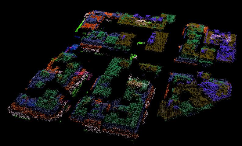


14 Implementation (2/2) Segmentation per 3m Detection and Removal of non-roof elements 3D Reconstruction of Buildings Roof Tops Edges Detection and Normalization


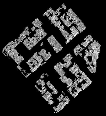
15 Proposed Methodology Screened Poisson reconstruction MeshLab CloudCompare Results Evaluation ü Smooth surfaces ü Detection and removal of noise and non-roof elements ü Distinct edge definition - smooth / regular shape ü Noisy rough surfaces ü Remaining noise referring to non-roof elements ü Noisy edges / wavy segments ü Complex surfaces


16 Thank you for your attention! National Technical University Of Athens School of Rural and Surveying Engineering Maria Gkeli, Surveying Engineer, PhD student Dr. Charalabos Ioannidis, Professor Gkeli, M., & Ioannidis, C., Automatic 3D Reconstruction of Buildings Roof Tops in Densely Urbanized Areas. In: 3D GeoInfo Conference, 1-2 October 2018,
Presented at the FIG Congress 2018, May 6-11, 2018 in Istanbul, Turkey
 Presented at the FIG Congress 2018, May 6-11, 2018 in Istanbul, Turkey Evangelos MALTEZOS, Charalabos IOANNIDIS, Anastasios DOULAMIS and Nikolaos DOULAMIS Laboratory of Photogrammetry, School of Rural
City-Modeling. Detecting and Reconstructing Buildings from Aerial Images and LIDAR Data
 City-Modeling Detecting and Reconstructing Buildings from Aerial Images and LIDAR Data Department of Photogrammetrie Institute for Geodesy and Geoinformation Bonn 300000 inhabitants At river Rhine University
Unwrapping of Urban Surface Models
 Unwrapping of Urban Surface Models Generation of virtual city models using laser altimetry and 2D GIS Abstract In this paper we present an approach for the geometric reconstruction of urban areas. It is
Automated Extraction of Buildings from Aerial LiDAR Point Cloud and Digital Imaging Datasets for 3D Cadastre - Preliminary Results
 Automated Extraction of Buildings from Aerial LiDAR Point Cloud and Digital Imaging Datasets for 3D Pankaj Kumar 1*, Alias Abdul Rahman 1 and Gurcan Buyuksalih 2 ¹Department of Geoinformation Universiti
Automatic Building Extrusion from a TIN model Using LiDAR and Ordnance Survey Landline Data
 Automatic Building Extrusion from a TIN model Using LiDAR and Ordnance Survey Landline Data Rebecca O.C. Tse, Maciej Dakowicz, Christopher Gold and Dave Kidner University of Glamorgan, Treforest, Mid Glamorgan,
LASERDATA LIS build your own bundle! LIS Pro 3D LIS 3.0 NEW! BETA AVAILABLE! LIS Road Modeller. LIS Orientation. LIS Geology.
 LIS 3.0...build your own bundle! NEW! LIS Geology LIS Terrain Analysis LIS Forestry LIS Orientation BETA AVAILABLE! LIS Road Modeller LIS Editor LIS City Modeller colors visualization I / O tools arithmetic
FOOTPRINTS EXTRACTION
 Building Footprints Extraction of Dense Residential Areas from LiDAR data KyoHyouk Kim and Jie Shan Purdue University School of Civil Engineering 550 Stadium Mall Drive West Lafayette, IN 47907, USA {kim458,
NATIONWIDE POINT CLOUDS AND 3D GEO- INFORMATION: CREATION AND MAINTENANCE GEORGE VOSSELMAN
 NATIONWIDE POINT CLOUDS AND 3D GEO- INFORMATION: CREATION AND MAINTENANCE GEORGE VOSSELMAN OVERVIEW National point clouds Airborne laser scanning in the Netherlands Quality control Developments in lidar
A DATA DRIVEN METHOD FOR FLAT ROOF BUILDING RECONSTRUCTION FROM LiDAR POINT CLOUDS
 A DATA DRIVEN METHOD FOR FLAT ROOF BUILDING RECONSTRUCTION FROM LiDAR POINT CLOUDS A. Mahphood, H. Arefi *, School of Surveying and Geospatial Engineering, College of Engineering, University of Tehran,
HEURISTIC FILTERING AND 3D FEATURE EXTRACTION FROM LIDAR DATA
 HEURISTIC FILTERING AND 3D FEATURE EXTRACTION FROM LIDAR DATA Abdullatif Alharthy, James Bethel School of Civil Engineering, Purdue University, 1284 Civil Engineering Building, West Lafayette, IN 47907
3D BUILDING MODEL GENERATION FROM AIRBORNE LASERSCANNER DATA BY STRAIGHT LINE DETECTION IN SPECIFIC ORTHOGONAL PROJECTIONS
 3D BUILDING MODEL GENERATION FROM AIRBORNE LASERSCANNER DATA BY STRAIGHT LINE DETECTION IN SPECIFIC ORTHOGONAL PROJECTIONS Ellen Schwalbe Institute of Photogrammetry and Remote Sensing Dresden University
Geometric Modeling in Graphics
 Geometric Modeling in Graphics Part 10: Surface reconstruction Martin Samuelčík www.sccg.sk/~samuelcik samuelcik@sccg.sk Curve, surface reconstruction Finding compact connected orientable 2-manifold surface
Municipal Projects in Cambridge Using a LiDAR Dataset. NEURISA Day 2012 Sturbridge, MA
 Municipal Projects in Cambridge Using a LiDAR Dataset NEURISA Day 2012 Sturbridge, MA October 15, 2012 Jeff Amero, GIS Manager, City of Cambridge Presentation Overview Background on the LiDAR dataset Solar
Research on-board LIDAR point cloud data pretreatment
 Acta Technica 62, No. 3B/2017, 1 16 c 2017 Institute of Thermomechanics CAS, v.v.i. Research on-board LIDAR point cloud data pretreatment Peng Cang 1, Zhenglin Yu 1, Bo Yu 2, 3 Abstract. In view of the
BUILDING MODEL RECONSTRUCTION FROM DATA INTEGRATION INTRODUCTION
 BUILDING MODEL RECONSTRUCTION FROM DATA INTEGRATION Ruijin Ma Department Of Civil Engineering Technology SUNY-Alfred Alfred, NY 14802 mar@alfredstate.edu ABSTRACT Building model reconstruction has been
3D Visualization through Planar Pattern Based Augmented Reality
 NATIONAL TECHNICAL UNIVERSITY OF ATHENS SCHOOL OF RURAL AND SURVEYING ENGINEERS DEPARTMENT OF TOPOGRAPHY LABORATORY OF PHOTOGRAMMETRY 3D Visualization through Planar Pattern Based Augmented Reality Dr.
Selective 4D modelling framework for spatialtemporal Land Information Management System
 Selective 4D modelling framework for spatialtemporal Land Information Management System A. Doulamis, S. Soile, N. Doulamis, C. Chrisouli, N. Grammalidis, K. Dimitropoulos C. Manesis, C. Potsiou, C. Ioannidis
REGISTRATION OF AIRBORNE LASER DATA TO SURFACES GENERATED BY PHOTOGRAMMETRIC MEANS. Y. Postolov, A. Krupnik, K. McIntosh
 REGISTRATION OF AIRBORNE LASER DATA TO SURFACES GENERATED BY PHOTOGRAMMETRIC MEANS Y. Postolov, A. Krupnik, K. McIntosh Department of Civil Engineering, Technion Israel Institute of Technology, Haifa,
03 - Reconstruction. Acknowledgements: Olga Sorkine-Hornung. CSCI-GA Geometric Modeling - Spring 17 - Daniele Panozzo
 3 - Reconstruction Acknowledgements: Olga Sorkine-Hornung Geometry Acquisition Pipeline Scanning: results in range images Registration: bring all range images to one coordinate system Stitching/ reconstruction:
Multi-View Matching & Mesh Generation. Qixing Huang Feb. 13 th 2017
 Multi-View Matching & Mesh Generation Qixing Huang Feb. 13 th 2017 Geometry Reconstruction Pipeline RANSAC --- facts Sampling Feature point detection [Gelfand et al. 05, Huang et al. 06] Correspondences
AUTOMATIC EXTRACTION OF BUILDING FEATURES FROM TERRESTRIAL LASER SCANNING
 AUTOMATIC EXTRACTION OF BUILDING FEATURES FROM TERRESTRIAL LASER SCANNING Shi Pu and George Vosselman International Institute for Geo-information Science and Earth Observation (ITC) spu@itc.nl, vosselman@itc.nl
Remote sensing techniques applied to seismic vulnerability assessment
 Remote sensing techniques applied to seismic vulnerability assessment JJ Arranz (josejuan.arranz@upm.es), Y. Torres (y.torres@upm.es), A. Haghi (a.haghi@alumnus.upm.es), J. Gaspar (jorge.gaspar@upm.es)
Isosurface Rendering. CSC 7443: Scientific Information Visualization
 Isosurface Rendering What is Isosurfacing? An isosurface is the 3D surface representing the locations of a constant scalar value within a volume A surface with the same scalar field value Isosurfaces form
Robotics Programming Laboratory
 Chair of Software Engineering Robotics Programming Laboratory Bertrand Meyer Jiwon Shin Lecture 8: Robot Perception Perception http://pascallin.ecs.soton.ac.uk/challenges/voc/databases.html#caltech car
AUTOMATIC EXTRACTION OF BUILDING ROOFS FROM PICTOMETRY S ORTHOGONAL AND OBLIQUE IMAGES
 AUTOMATIC EXTRACTION OF BUILDING ROOFS FROM PICTOMETRY S ORTHOGONAL AND OBLIQUE IMAGES Yandong Wang Pictometry International Corp. Suite A, 100 Town Centre Dr., Rochester, NY14623, the United States yandong.wang@pictometry.com
Multi-ray photogrammetry: A rich dataset for the extraction of roof geometry for 3D reconstruction
 Multi-ray photogrammetry: A rich dataset for the extraction of roof geometry for 3D reconstruction Andrew McClune, Pauline Miller, Jon Mills Newcastle University David Holland Ordnance Survey Background
BUILDING DETECTION AND STRUCTURE LINE EXTRACTION FROM AIRBORNE LIDAR DATA
 BUILDING DETECTION AND STRUCTURE LINE EXTRACTION FROM AIRBORNE LIDAR DATA C. K. Wang a,, P.H. Hsu a, * a Dept. of Geomatics, National Cheng Kung University, No.1, University Road, Tainan 701, Taiwan. China-
CRF Based Point Cloud Segmentation Jonathan Nation
 CRF Based Point Cloud Segmentation Jonathan Nation jsnation@stanford.edu 1. INTRODUCTION The goal of the project is to use the recently proposed fully connected conditional random field (CRF) model to
Surface Reconstruction. Vincent Rabaud
 Surface Reconstruction Vincent Rabaud November 03, 2011 Outline 1. Introduction 2. Plane Detection Problem definition Plane estimation Hull refinement 3. Moving least squares Problem Gist 4. Triangulation
INCREASING CLASSIFICATION QUALITY BY USING FUZZY LOGIC
 JOURNAL OF APPLIED ENGINEERING SCIENCES VOL. 1(14), issue 4_2011 ISSN 2247-3769 ISSN-L 2247-3769 (Print) / e-issn:2284-7197 INCREASING CLASSIFICATION QUALITY BY USING FUZZY LOGIC DROJ Gabriela, University
Lidar and GIS: Applications and Examples. Dan Hedges Clayton Crawford
 Lidar and GIS: Applications and Examples Dan Hedges Clayton Crawford Outline Data structures, tools, and workflows Assessing lidar point coverage and sample density Creating raster DEMs and DSMs Data area
Automatic urbanity cluster detection in street vector databases with a raster-based algorithm
 Automatic urbanity cluster detection in street vector databases with a raster-based algorithm Volker Walter, Steffen Volz University of Stuttgart Institute for Photogrammetry Geschwister-Scholl-Str. 24D
AUTOMATIC PROCESSING OF MOBILE LASER SCANNER POINT CLOUDS FOR BUILDING FAÇADE DETECTION
 AUTOMATIC PROCESSING OF MOBILE LASER SCANNER POINT CLOUDS FOR BUILDING FAÇADE DETECTION Nalani Hetti Arachchige*, Sanka Nirodha Perera, Hans-Gerd Maas Institute of Photogrammetry and Remote Sensing, Technische
DETECTION AND ROBUST ESTIMATION OF CYLINDER FEATURES IN POINT CLOUDS INTRODUCTION
 DETECTION AND ROBUST ESTIMATION OF CYLINDER FEATURES IN POINT CLOUDS Yun-Ting Su James Bethel Geomatics Engineering School of Civil Engineering Purdue University 550 Stadium Mall Drive, West Lafayette,
3D Environment Reconstruction
 3D Environment Reconstruction Using Modified Color ICP Algorithm by Fusion of a Camera and a 3D Laser Range Finder The 2009 IEEE/RSJ International Conference on Intelligent Robots and Systems October 11-15,
Automatic DTM Extraction from Dense Raw LIDAR Data in Urban Areas
 Automatic DTM Extraction from Dense Raw LIDAR Data in Urban Areas Nizar ABO AKEL, Ofer ZILBERSTEIN and Yerach DOYTSHER, Israel Key words: LIDAR, DSM, urban areas, DTM extraction. SUMMARY Although LIDAR
Outline of Presentation. Introduction to Overwatch Geospatial Software Feature Analyst and LIDAR Analyst Software
 Outline of Presentation Automated Feature Extraction from Terrestrial and Airborne LIDAR Presented By: Stuart Blundell Overwatch Geospatial - VLS Ops Co-Author: David W. Opitz Overwatch Geospatial - VLS
Introduction to Image Processing and Analysis. Applications Scientist Nanotechnology Measurements Division Materials Science Solutions Unit
 Introduction to Image Processing and Analysis Gilbert Min Ph D Gilbert Min, Ph.D. Applications Scientist Nanotechnology Measurements Division Materials Science Solutions Unit Working with SPM Image Files
Dynamic 3D representation of information using low cost Cloud ready Technologies
 National Technical University Of Athens School of Rural and Surveying Engineering Laboratory of Photogrammetry Dynamic 3D representation of information using low cost Cloud ready Technologies George MOURAFETIS,
AUTOMATIC EXTRACTION OF LARGE COMPLEX BUILDINGS USING LIDAR DATA AND DIGITAL MAPS
 AUTOMATIC EXTRACTION OF LARGE COMPLEX BUILDINGS USING LIDAR DATA AND DIGITAL MAPS Jihye Park a, Impyeong Lee a, *, Yunsoo Choi a, Young Jin Lee b a Dept. of Geoinformatics, The University of Seoul, 90
SEGMENTATION AND CLASSIFICATION OF POINT CLOUDS FROM DENSE AERIAL IMAGE MATCHING
 SEGMENTATION AND CLASSIFICATION OF POINT CLOUDS FROM DENSE AERIAL IMAGE MATCHING ABSTRACT Mohammad Omidalizarandi 1 and Mohammad Saadatseresht 2 1 University of Stuttgart, Germany mohammadzarandi@gmail.com
Motivation. Freeform Shape Representations for Efficient Geometry Processing. Operations on Geometric Objects. Functional Representations
 Motivation Freeform Shape Representations for Efficient Geometry Processing Eurographics 23 Granada, Spain Geometry Processing (points, wireframes, patches, volumes) Efficient algorithms always have to
Automated Processing for 3D Mosaic Generation, a Change of Paradigm
 Automated Processing for 3D Mosaic Generation, a Change of Paradigm Frank BIGNONE, Japan Key Words: 3D Urban Model, Street Imagery, Oblique imagery, Mobile Mapping System, Parallel processing, Digital
Biometrics Technology: Image Processing & Pattern Recognition (by Dr. Dickson Tong)
") Biometrics Technology: Image Processing & Pattern Recognition (by Dr. Dickson Tong) References: [1] http://homepages.inf.ed.ac.uk/rbf/hipr2/index.htm [2] http://www.cs.wisc.edu/~dyer/cs540/notes/vision.html
Biometrics Technology: Image Processing & Pattern Recognition (by Dr. Dickson Tong) References: [1] http://homepages.inf.ed.ac.uk/rbf/hipr2/index.htm [2] http://www.cs.wisc.edu/~dyer/cs540/notes/vision.html
CIS 467/602-01: Data Visualization
 CIS 467/60-01: Data Visualization Isosurfacing and Volume Rendering Dr. David Koop Fields and Grids Fields: values come from a continuous domain, infinitely many values - Sampled at certain positions to
Intensity Augmented ICP for Registration of Laser Scanner Point Clouds
 Intensity Augmented ICP for Registration of Laser Scanner Point Clouds Bharat Lohani* and Sandeep Sashidharan *Department of Civil Engineering, IIT Kanpur Email: blohani@iitk.ac.in. Abstract While using
Point Clouds to IFC/BrIM Objective:
 Point Clouds to IFC/BrIM Objective: Develop and demonstrate a point cloud data processing solution, which takes a point cloud of a bridge obtained from laser scanning as input, and generates a solid model
A COMPETITION BASED ROOF DETECTION ALGORITHM FROM AIRBORNE LIDAR DATA
 A COMPETITION BASED ROOF DETECTION ALGORITHM FROM AIRBORNE LIDAR DATA HUANG Xianfeng State Key Laboratory of Informaiton Engineering in Surveying, Mapping and Remote Sensing (Wuhan University), 129 Luoyu
Segmentation of 3D Photogrammetric Point Cloud for 3D Building Modeling
 Segmentation of 3D Photogrammetric Point Cloud for 3D Building Modeling EMRE ÖZDEMİR 1,2, Fabio Remondino 1 1 3D Optical Metrology unit Bruno Kessler Foundation (FBK) Trento, Italy https://3dom.fbk.eu
TOOLS FOR ANALYZING SHAPES OF CURVES AND SURFACES. ANUJ SRIVASTAVA Department of Statistics Florida State University
 TOOLS FOR ANALYZING SHAPES OF CURVES AND SURFACES ANUJ SRIVASTAVA Department of Statistics Florida State University 1 MURI: INTGERATED FUSION AND SENSOR MANAGEMENT FOR ATE Innovative Front-End Processing
Single Particle Reconstruction Techniques
 T H E U N I V E R S I T Y of T E X A S S C H O O L O F H E A L T H I N F O R M A T I O N S C I E N C E S A T H O U S T O N Single Particle Reconstruction Techniques For students of HI 6001-125 Computational
Investigating the Structural Condition of Individual Trees using LiDAR Metrics
 Investigating the Structural Condition of Individual Trees using LiDAR Metrics Jon Murray 1, George Alan Blackburn 1, Duncan Whyatt 1, Christopher Edwards 2. 1 Lancaster Environment Centre, Lancaster University,
AUTOMATIC 3D BUILDING RECONSTRUCTION FROM DEMS : AN APPLICATION TO PLEIADES SIMULATIONS
 AUTOMATIC 3D BUILDING RECONSTRUCTION FROM DEMS : AN APPLICATION TO PLEIADES SIMULATIONS Florent Lafarge 1,2, Xavier Descombes 1, Josiane Zerubia 1 and Marc Pierrot-Deseilligny 2 1 Ariana Research Group
Contours & Implicit Modelling 4
 Brief Recap Contouring & Implicit Modelling Contouring Implicit Functions Visualisation Lecture 8 lecture 6 Marching Cubes lecture 3 visualisation of a Quadric toby.breckon@ed.ac.uk Computer Vision Lab.
Robust Moving Least-squares Fitting with Sharp Features
 Survey of Methods in Computer Graphics: Robust Moving Least-squares Fitting with Sharp Features S. Fleishman, D. Cohen-Or, C. T. Silva SIGGRAPH 2005. Method Pipeline Input: Point to project on the surface.
Data Preprocessing. Why Data Preprocessing? MIT-652 Data Mining Applications. Chapter 3: Data Preprocessing. Multi-Dimensional Measure of Data Quality
 Why Data Preprocessing? Data in the real world is dirty incomplete: lacking attribute values, lacking certain attributes of interest, or containing only aggregate data e.g., occupation = noisy: containing
AUTOMATIC GENERATION OF DIGITAL BUILDING MODELS FOR COMPLEX STRUCTURES FROM LIDAR DATA
 AUTOMATIC GENERATION OF DIGITAL BUILDING MODELS FOR COMPLEX STRUCTURES FROM LIDAR DATA Changjae Kim a, Ayman Habib a, *, Yu-Chuan Chang a a Geomatics Engineering, University of Calgary, Canada - habib@geomatics.ucalgary.ca,
Contours & Implicit Modelling 1
 Contouring & Implicit Modelling Visualisation Lecture 8 Institute for Perception, Action & Behaviour School of Informatics Contours & Implicit Modelling 1 Brief Recap Contouring Implicit Functions lecture
3D Shape Modeling by Deformable Models. Ye Duan
 3D Shape Modeling by Deformable Models Ye Duan Previous Work Shape Reconstruction from 3D data. Volumetric image datasets. Unorganized point clouds. Interactive Mesh Editing. Vertebral Dataset Vertebral
Urban Scene Segmentation, Recognition and Remodeling. Part III. Jinglu Wang 11/24/2016 ACCV 2016 TUTORIAL
 Part III Jinglu Wang Urban Scene Segmentation, Recognition and Remodeling 102 Outline Introduction Related work Approaches Conclusion and future work o o - - ) 11/7/16 103 Introduction Motivation Motivation
POINT CLOUD ANALYSIS FOR ROAD PAVEMENTS IN BAD CONDITIONS INTRODUCTION
 POINT CLOUD ANALYSIS FOR ROAD PAVEMENTS IN BAD CONDITIONS Yoshiyuki Yamamoto, Associate Professor Yasuhiro Shimizu, Doctoral Student Eiji Nakamura, Professor Masayuki Okugawa, Associate Professor Aichi
Proximity Graphs for Defining Surfaces over Point Clouds
 Proximity Graphs for Defining Surfaces over Point Clouds Germany Gabriel Zachmann University of Bonn Germany Zurich June, 2004 Surface Definition based on MLS Surface can be approximated by implicit function,
Model Fitting. Introduction to Computer Vision CSE 152 Lecture 11
 Model Fitting CSE 152 Lecture 11 Announcements Homework 3 is due May 9, 11:59 PM Reading: Chapter 10: Grouping and Model Fitting What to do with edges? Segment linked edge chains into curve features (e.g.,
1. Introduction. A CASE STUDY Dense Image Matching Using Oblique Imagery Towards All-in- One Photogrammetry
 Submitted to GIM International FEATURE A CASE STUDY Dense Image Matching Using Oblique Imagery Towards All-in- One Photogrammetry Dieter Fritsch 1, Jens Kremer 2, Albrecht Grimm 2, Mathias Rothermel 1
Tree Detection in LiDAR Data
 Tree Detection in LiDAR Data John Secord and Avideh Zakhor Electrical Engineering and Computer Science Dept. University of California, Berkeley {secord,avz}@eecs.berkeley.edu Abstract In this paper, we
COMPONENTS. The web interface includes user administration tools, which allow companies to efficiently distribute data to internal or external users.
 COMPONENTS LASERDATA LIS is a software suite for LiDAR data (TLS / MLS / ALS) management and analysis. The software is built on top of a GIS and supports both point and raster data. The following software
3D MESH RECONSTRUCTION USING PHOTOGRAMMETRY EX. 1 VISUAL SFM + MESHLAB. Afonso Maria C. F. A. Gonçalves
 3D MESH RECONSTRUCTION USING PHOTOGRAMMETRY EX. 1 VISUAL SFM + MESHLAB Afonso Maria C. F. A. Gonçalves 20130528 ADVANCED STUDIES PROGRAM IN COMPUTATION APPLIED TO ARCHITECTURE, URBAN PLANNING AND DESIGN
LIDAR Quality Levels Part 1
 Lewis Graham, CTO GeoCue Group The LIDAR community has been gradually adopting the terminology Quality Level to categorize airborne LIDAR data. The idea is to use a simple scheme to characterize the more
Image Segmentation and Registration
 Image Segmentation and Registration Dr. Christine Tanner (tanner@vision.ee.ethz.ch) Computer Vision Laboratory, ETH Zürich Dr. Verena Kaynig, Machine Learning Laboratory, ETH Zürich Outline Segmentation
Optimizing Building Geometry to Increase the Energy Yield in the Built Environment
 Cornell University Laboratory for Intelligent Machine Systems Optimizing Building Geometry to Increase the Energy Yield in the Built Environment Malika Grayson Dr. Ephrahim Garcia Laboratory for Intelligent
Identifying man-made objects along urban road corridors from mobile LiDAR data
 Identifying man-made objects along urban road corridors from mobile LiDAR data Hongchao Fan 1 and Wei Yao 2 1 Chair of GIScience, Heidelberg University, Berlinerstr. 48, 69120 Heidelberg, Hongchao.fan@geog.uni-heidelberg.de
AN ADAPTIVE APPROACH FOR SEGMENTATION OF 3D LASER POINT CLOUD
 AN ADAPTIVE APPROACH FOR SEGMENTATION OF 3D LASER POINT CLOUD Z. Lari, A. F. Habib, E. Kwak Department of Geomatics Engineering, University of Calgary, Calgary, Alberta, Canada TN 1N4 - (zlari, ahabib,
Data Visualization (DSC 530/CIS )
") Data Visualization (DSC 530/CIS 60-0) Isosurfaces & Volume Rendering Dr. David Koop Fields & Grids Fields: - Values come from a continuous domain, infinitely many values - Sampled at certain positions
Data Visualization (DSC 530/CIS 60-0) Isosurfaces & Volume Rendering Dr. David Koop Fields & Grids Fields: - Values come from a continuous domain, infinitely many values - Sampled at certain positions
Geodesics in heat: A new approach to computing distance
 Geodesics in heat: A new approach to computing distance based on heat flow Diana Papyan Faculty of Informatics - Technische Universität München Abstract In this report we are going to introduce new method
3D object recognition used by team robotto
 3D object recognition used by team robotto Workshop Juliane Hoebel February 1, 2016 Faculty of Computer Science, Otto-von-Guericke University Magdeburg Content 1. Introduction 2. Depth sensor 3. 3D object
LiDAR Engineering and Design Applications. Sample Data
 LiDAR Engineering and Design Applications Sample Data High density LiDAR will return points on any visible part of a structure. Modeling of Existing Structures 2 The distance between any two positions
Chapters 1 7: Overview
 Chapters 1 7: Overview Photogrammetric mapping: introduction, applications, and tools GNSS/INS-assisted photogrammetric and LiDAR mapping LiDAR mapping: principles, applications, mathematical model, and
Data Visualization (DSC 530/CIS )
") Data Visualization (DSC 530/CIS 60-01) Scalar Visualization Dr. David Koop Online JavaScript Resources http://learnjsdata.com/ Good coverage of data wrangling using JavaScript Fields in Visualization Scalar
Data Visualization (DSC 530/CIS 60-01) Scalar Visualization Dr. David Koop Online JavaScript Resources http://learnjsdata.com/ Good coverage of data wrangling using JavaScript Fields in Visualization Scalar
Data Representation in Visualisation
 Data Representation in Visualisation Visualisation Lecture 4 Taku Komura Institute for Perception, Action & Behaviour School of Informatics Taku Komura Data Representation 1 Data Representation We have
A Vector Agent-Based Unsupervised Image Classification for High Spatial Resolution Satellite Imagery
 A Vector Agent-Based Unsupervised Image Classification for High Spatial Resolution Satellite Imagery K. Borna 1, A. B. Moore 2, P. Sirguey 3 School of Surveying University of Otago PO Box 56, Dunedin,
AUTOMATED RECONSTRUCTION OF WALLS FROM AIRBORNE LIDAR DATA FOR COMPLETE 3D BUILDING MODELLING
 AUTOMATED RECONSTRUCTION OF WALLS FROM AIRBORNE LIDAR DATA FOR COMPLETE 3D BUILDING MODELLING Yuxiang He*, Chunsun Zhang, Mohammad Awrangjeb, Clive S. Fraser Cooperative Research Centre for Spatial Information,
AUTOMATIC EXTRACTION OF BUILDING ROOF PLANES FROM AIRBORNE LIDAR DATA APPLYING AN EXTENDED 3D RANDOMIZED HOUGH TRANSFORM
 AUTOMATIC EXTRACTION OF BUILDING ROOF PLANES FROM AIRBORNE LIDAR DATA APPLYING AN EXTENDED 3D RANDOMIZED HOUGH TRANSFORM Evangelos Maltezos*, Charalabos Ioannidis Laboratory of Photogrammetry, School of
Urban Damage Detection in High Resolution Amplitude SAR Images
 Urban Damage Detection in High Resolution Amplitude SAR Images P.T.B. Brett Supervisors: Dr. R. Guida, Prof. Sir M. Sweeting 21st June 2013 1 Overview 1 Aims, motivation & scope 2 Urban SAR background
Homework. Gaussian, Bishop 2.3 Non-parametric, Bishop 2.5 Linear regression Pod-cast lecture on-line. Next lectures:
 Homework Gaussian, Bishop 2.3 Non-parametric, Bishop 2.5 Linear regression 3.0-3.2 Pod-cast lecture on-line Next lectures: I posted a rough plan. It is flexible though so please come with suggestions Bayes
University of Florida CISE department Gator Engineering. Clustering Part 2
 Clustering Part 2 Dr. Sanjay Ranka Professor Computer and Information Science and Engineering University of Florida, Gainesville Partitional Clustering Original Points A Partitional Clustering Hierarchical
Assignment 4: Mesh Parametrization
 CSCI-GA.3033-018 - Geometric Modeling Assignment 4: Mesh Parametrization In this exercise you will Familiarize yourself with vector field design on surfaces. Create scalar fields whose gradients align
CT NOISE POWER SPECTRUM FOR FILTERED BACKPROJECTION AND ITERATIVE RECONSTRUCTION
 CT NOISE POWER SPECTRUM FOR FILTERED BACKPROJECTION AND ITERATIVE RECONSTRUCTION Frank Dong, PhD, DABR Diagnostic Physicist, Imaging Institute Cleveland Clinic Foundation and Associate Professor of Radiology
Geometric and Solid Modeling. Problems
 Geometric and Solid Modeling Problems Define a Solid Define Representation Schemes Devise Data Structures Construct Solids Page 1 Mathematical Models Points Curves Surfaces Solids A shape is a set of Points
Quality Guided Image Denoising for Low-Cost Fundus Imaging
 Quality Guided Image Denoising for Low-Cost Fundus Imaging Thomas Köhler1,2, Joachim Hornegger1,2, Markus Mayer1,2, Georg Michelson2,3 20.03.2012 1 Pattern Recognition Lab, Ophthalmic Imaging Group 2 Erlangen
Deep Learning for Robust Normal Estimation in Unstructured Point Clouds. Alexandre Boulch. Renaud Marlet
 Deep Learning for Robust Normal Estimation in Unstructured Point Clouds Alexandre Boulch Renaud Marlet Normal estimation in point clouds Normal: 3D normalized vector At each point: local orientation of
DIGITAL TERRAIN MODELS
 DIGITAL TERRAIN MODELS 1 Digital Terrain Models Dr. Mohsen Mostafa Hassan Badawy Remote Sensing Center GENERAL: A Digital Terrain Models (DTM) is defined as the digital representation of the spatial distribution
Design Workflow for AM: From CAD to Part
 Design Workflow for AM: From CAD to Part Sanjay Joshi Professor of Industrial and Manufacturing Engineering Penn State University Offered by: Center for Innovative Materials Processing through Direct Digital
University of Florida CISE department Gator Engineering. Clustering Part 5
 Clustering Part 5 Dr. Sanjay Ranka Professor Computer and Information Science and Engineering University of Florida, Gainesville SNN Approach to Clustering Ordinary distance measures have problems Euclidean
SUPPLEMENTARY FILE S1: 3D AIRWAY TUBE RECONSTRUCTION AND CELL-BASED MECHANICAL MODEL. RELATED TO FIGURE 1, FIGURE 7, AND STAR METHODS.
 SUPPLEMENTARY FILE S1: 3D AIRWAY TUBE RECONSTRUCTION AND CELL-BASED MECHANICAL MODEL. RELATED TO FIGURE 1, FIGURE 7, AND STAR METHODS. 1. 3D AIRWAY TUBE RECONSTRUCTION. RELATED TO FIGURE 1 AND STAR METHODS
Surface and Terrain Models
 Advanced Matching Techniques for High Precision Surface and Terrain Models Introduction Comeback of image matching for DTM & DSM generation Very few professional tools for DSM generation from image matching
Project Updates Short lecture Volumetric Modeling +2 papers
 Volumetric Modeling Schedule (tentative) Feb 20 Feb 27 Mar 5 Introduction Lecture: Geometry, Camera Model, Calibration Lecture: Features, Tracking/Matching Mar 12 Mar 19 Mar 26 Apr 2 Apr 9 Apr 16 Apr 23
Surface Reconstruction from Unorganized Points
 Survey of Methods in Computer Graphics: Surface Reconstruction from Unorganized Points H. Hoppe, T. DeRose, T. Duchamp, J. McDonald, W. Stuetzle SIGGRAPH 1992. Article and Additional Material at: http://research.microsoft.com/en-us/um/people/hoppe/proj/recon/
Data Mining 4. Cluster Analysis
 Data Mining 4. Cluster Analysis 4.5 Spring 2010 Instructor: Dr. Masoud Yaghini Introduction DBSCAN Algorithm OPTICS Algorithm DENCLUE Algorithm References Outline Introduction Introduction Density-based
GENERATING BUILDING OUTLINES FROM TERRESTRIAL LASER SCANNING
 GENERATING BUILDING OUTLINES FROM TERRESTRIAL LASER SCANNING Shi Pu International Institute for Geo-information Science and Earth Observation (ITC), Hengelosestraat 99, P.O. Box 6, 7500 AA Enschede, The
Introduction to Computer Graphics. Modeling (3) April 27, 2017 Kenshi Takayama
 April 27, 2017 Kenshi Takayama") Introduction to Computer Graphics Modeling (3) April 27, 2017 Kenshi Takayama Solid modeling 2 Solid models Thin shapes represented by single polygons Unorientable Clear definition of inside & outside
Introduction to Computer Graphics Modeling (3) April 27, 2017 Kenshi Takayama Solid modeling 2 Solid models Thin shapes represented by single polygons Unorientable Clear definition of inside & outside