3D recording of archaeological excavation
|
|
|
- Deirdre Nelson
- 5 years ago
- Views:
Transcription

1 5 th International Conference Remote Sensing in Archaeology The Age of Sensing October Duke University 3D recording of archaeological excavation Stefano Campana UNIVERSITY of CAMBRIDGE Faculty of Classics & McDonald Institute for Archaeological Research Matteo Sordini ATS s.r.l. Digital Technologies for Cultural Heritage Siena - Italy Francesco Brogi UNIVERSITY of SIENA Landscape Archaeology & Remote Sensing LAB


2 Introduction - task Archaeological excavation is a destructive and not repeatable process: documentation of archaeological stratigraphy and relationships between layers is a fundamental and time consuming aspect of the work of archaeologist aimed at understanding the history of the context. 5 th International Conference Remote Sensing in Archaeology The Age of Sensing October Duke University
3 Introduction - recording archaeological excavation This process is time consuming because drawing complex structures can take long time and the excavation activities are subordinate to documentation. Direct-survey and manual drawing are also affected by a low level of standardization and accuracy and this errors propagated in several years of archaeological campaign can lead the archaeologists in misunderstanding and mistakes. Traditional techniques like direct survey and manual drawing allow very narrow margin of errors in interpretation of the context during fieldwork: after the excavation (interpretation) the archaeologist records through manual measurement and drawings the shape of layers and their relationship, before proceeding to their destruction. 5 th International Conference Remote Sensing in Archaeology The Age of Sensing October Duke University


4 Introduction - topographic instruments In the last decades this problems have been progressively reduced by the introduction of instrumental survey devices and digital imaging. Since the start of Pava excavation in 2004 we started to use topographic GPS, total station to increase accuracy of the documentation. 5 th International Conference Remote Sensing in Archaeology The Age of Sensing October Duke University


5 Digital imaging In the beginning digital imaging was used for a massive qualitative documentation of the layers. Photographs did not replace traditional excavation recording but rather complemented them, adding a new form of documentation which in its turn required interpretation and sometimes graphical representation of the archaeological information present in the photographs. 5 th International Conference Remote Sensing in Archaeology The Age of Sensing October Duke University

6 Digital imaging Hardware The creation of metric-images (ortho or rectified) was possible only with nadir images, acquired with mats, poles and towers. Metric images adds quantitative information to the images. The height but also inflexibility achieved with this tools limited this task to small areas as well as the needs of a large amount of ground control point. 5 th International Conference Remote Sensing in Archaeology The Age of Sensing October Duke University

.")
7 Aerial Imagery Since the beginning of Pava project in 2004, we started to experiment aerial imagery for documenting the site. During the first years, at the end of campaign, we acquired images using a Cessna light aircraft and digital SRL camera, taking picture of the site from many point of view (oblique aerial photography). 5 th International Conference Remote Sensing in Archaeology The Age of Sensing October Duke University


8 Aerial Imagery This kind of approach presents many limitations for the systematic use aimed at the detailed and the accurate documentation of archaeological excavation: l Flight altitude of Cessna aircraft was too high to record details and small objects (low GSD) l Flying systematically with Cessna was not cost effective and flexible. 5 th International Conference Remote Sensing in Archaeology The Age of Sensing October Duke University

 and during post-processing tasks.")
9 3D Laser Scanner Since 2007 we started to experiment laser scanner to perform 3D recording of excavation. While the quality of documentation was extremely accurate, the use of instruments was time consuming both on field (occlusions) and during post-processing tasks. Another limit of laser documentation was the complexity of the whole pipeline that always needed expert user and engineer support.


10 UAV We started to experiment the use of UAV in 2007 in cooperation with Zenit s.r.l. company and Fbk Foundation. We used the Microdrones MD 200 in order to produce 2D and 3D documentation of Pava excavation. This UAV was equipped with 4 rotors, carrying 200g of payload. MD-200 can fly by remote control or autonomously with a GPS navigation system.
 The MD-200 system was time consuming for setting up all equipment and to")


11 UAV The experimentation revealed some hardware limitations (unreliability of drone) The MD-200 system was time consuming for setting up all equipment and to be ready to flight. It was strongly affected by atmospheric conditions. Furthermore the MD-200 can carry only some specific kind of compact camera: the images acquired with that hardware had a lossy compression and produced very poor images in most of cases unfitting the requirement needed for photogrammetric processing.
 Almost by chance we started the testing Aibotix X6 Hexacopter System.")

12 UAV In 2013 we were ready to give up (particularly after the key note of A.Gruen at S2P in Beijing at the end of 2012) Almost by chance we started the testing Aibotix X6 Hexacopter System. It can carry up to 2,5 KG payload allow to use a reflex or mirrorless camera producing a very high quality images. It can fly by manual control or autonomously with the integrated GPS navigation system. 5 th International Conference Remote Sensing in Archaeology The Age of Sensing October Duke University


13 UAV This system is less affected by atmospheric condition, making the system more versatile in archaeological fieldwork. The system set-up is very fast, in few minutes the copter is ready to fly. The level of detail of surfaces, the repeatability of flights with identical parameters and the high speed in performing the photogrammetric coverage make this instrument particularly suited to the diachronic documentation of the excavation


14 Image Based Modeling! New software allow the three dimensional recording of objects from images, providing s e m i o r f u l l a u t o m a t i c processing steps and giving back a dense point cloud and, in some cases, the textured surface mesh model (Fassi et alii 2013).! The introduction of low cost automated photogrammetric packages based on Structure F r o m M o t i o n T e c h n i q u e represent a big (r)evolution in archaeological documentation, allowing the systematic use of 3D recording DIRECTLY M A N A G E D B Y T H E ARCHAEOLOGIST.
 we developed a pipeline for archaeological documentation")
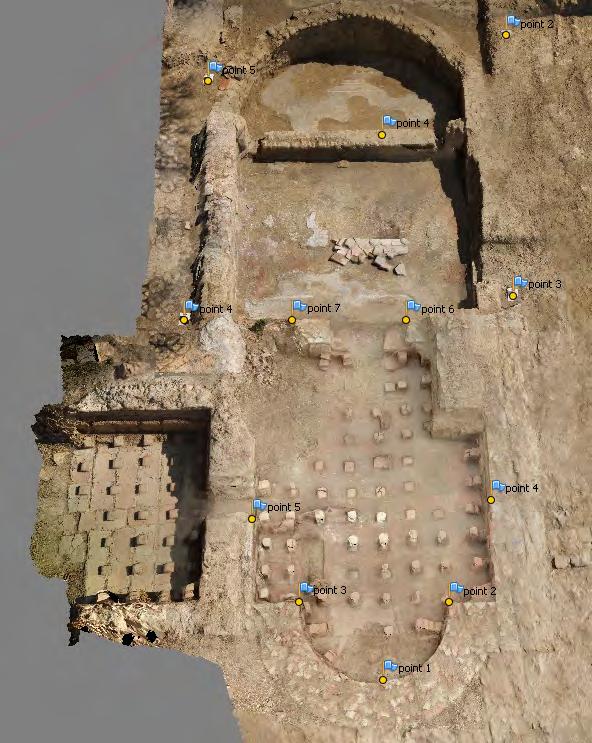
15 Santa Marta Excavation! During Santa Marta excavation (2012 ongoing) we developed a pipeline for archaeological documentation based on 3D recording and digital drawing of the contexts, features and layers.!!

16 Topography The first important aspect of our pipeline is the topographic approach: we use a topographic GPS with real time differential correction for absolute coordinate measurement and a total station to measure GCPs during fieldwork. Absolute coordinates of each GCP have been calculated using topographical GPS with real-time differential correction, with 30 minutes of static measurement. TS is oriented using GCPs on the field in gauss boaga coordinate system, so we get all survey points directly in absolute coordinate system and no post-processing tasks are needed. 5 th International Conference Remote Sensing in Archaeology The Age of Sensing October Duke University

17 Aerial Images Fast documentation and survey of large areas 5 th International Conference Remote Sensing in Archaeology The Age of Sensing October Duke University

18 Aerial Images Fast documentation and survey of large areas 5 th International Conference Remote Sensing in Archaeology The Age of Sensing October Duke University

19 Aerial Images Fast documentation and survey of large areas 5 th International Conference Remote Sensing in Archaeology The Age of Sensing October Duke University


20 Terrestrial Images fast documentation and survey of layers 5 th International Conference Remote Sensing in Archaeology The Age of Sensing October Duke University
21 Image based Modeling Ground Sample Distance Resolution can be managed during image acquisition by adjusting the distance between camera and target-object. It can be estimated by this formula: pixel size x distance focal length In case of low distances between camera and object, it can be adjusted during the processing of data-sets, rescaling images or decimating point cloud.


22 Image based Modeling To process our image datasets we choose a low cost automated photogrammetry package, Agisoft Photoscan Pro. The extraction and matching of features in Photoscan are made with an algorithm similar to the well known SIFT (Scale-invariant feature transform)


23 Image based Modeling In archaeological excavation some layers have very homogeneous texture. In this cases SIFT algorithm may have problems to detect and match features properly. 5 th International Conference Remote Sensing in Archaeology The Age of Sensing October Duke University


24 Image based Modeling To overcome this limit is important to use control point measured with TS and match them a priori in the images

25 Image based Modeling During recording layers of archaeological excavation it's important to proceed keeping an high level of accuracy in order to produce reliable documentation in which the spatial relationships between layers are properly expressed High level of accuracy is also needed to integrate different diachronic models

26 Image based Modeling After orientations Photoscan can extract dense point cloud from the dataset matching images throught different alghoritms according to the requirements of the user. It's important to choose appropriate GSD to describe context: all significant details must be recorded without create redundant points that can increase dimensions of the dataset and making hard to manage it.

27 Image based Modeling Dense point cloud can be processed with Photoscan or, if needed, with external software like Meshlab to create a polygonal mesh.


28 Image based Modeling The poisson surface algorithm used by meshlab allows user to customize meshing parameters Meshlab allows to visualize geometry with different shaders and light position Radiance scaling shader can be useful for enhanced surface depiction

29 Image based Modeling The resulting model can be textured with Photoscan using different methods and performing a color correction that reduce the chromatic differences between images


30 4D Modeling The data sets obtained with IBM shows different situation of parts or whole excavation For practical reasons, the excavation of large areas cannot show a diachronic phase at same time September 2013 October 2013 July th International Conference Remote Sensing in Archaeology The Age of Sensing October Duke University
31 4D Modeling 3D modeling can be a powerful tool (and sometime the only way) to show diachronic phases of whole excavation. A diachronic model can be obtained by removing point from older datasets that overlaps with new. All dataset are in same coordinate system: no alignment is needed The global mesh is generated using poisson algorithm and textured in photoscan disabling older images for each new area

32 4D Modeling


33 Digital drawings The excavation data is managed inside a geographic information system where are recorded alphanumeric and spatial information. The digital drawing of each layer is performed in post processing through Ortho-images extracted from 3D datasets

34 Digital drawings


35 Digital drawings The digitizing can be performed at more detailed scale and in non-comparable faster time/accuracy than traditional/direct drawing: in few time is possible to digitize large areas and representing all small/articulated details that in manual drawing takes long time to be reproduced as well as manual-drawing skills.

36 Digital drawings
37 Digital drawings

38 Approximate time effort in a typical UAV-based photogrammetric workflow Remondino, Nex 2013 UAV for 3D mapping applications: a review, Applied Geomatics
39 Conclusions The recording of archaeological features in excavations goes beyond the graphical representation involving the essence of the archaeological process based on the understanding and the interpretation of the contexts. 3D recording is the best way of measuring and documenting archaeological features in terms of detail and accuracy, that need we to be performed by archaeologist. Standardization of archaeological documentation on excavation The role of drone should be considered crucial reducing dramatically on site documentation timing and therefore allowing archaeologists keeping on excavation. The traditional/manual survey/drawing methods on site can be considered totally obsolete both because time consuming and due to quality/ accuracy/precision issue. 5 th International Conference Remote Sensing in Archaeology The Age of Sensing October Duke University

40 thank you for your attention
THREE DIMENSIONAL CURVE HALL RECONSTRUCTION USING SEMI-AUTOMATIC UAV
 THREE DIMENSIONAL CURVE HALL RECONSTRUCTION USING SEMI-AUTOMATIC UAV Muhammad Norazam Zulgafli 1 and Khairul Nizam Tahar 1,2 1 Centre of Studies for Surveying Science and Geomatics, Faculty of Architecture
Reality Modeling Drone Capture Guide
 Reality Modeling Drone Capture Guide Discover the best practices for photo acquisition-leveraging drones to create 3D reality models with ContextCapture, Bentley s reality modeling software. Learn the
Coastal Survey of archaeological sites using drones
 Coastal Survey of archaeological sites using drones In Poseidon s Realm XXI Underwater archaeology - interdisciplinary approaches and technical innovations Dimitrios Skarlatos, Savvidou Eleni Photogrammetric
Journal Online Jaringan COT POLIPD (JOJAPS) Accuracy Assessment of Height Coordinate Using Unmanned Aerial Vehicle Images Based On Leveling Height
 Accuracy Assessment of Height Coordinate Using Unmanned Aerial Vehicle Images Based On Leveling Height") JOJAPS eissn 2504-8457 Abstract Journal Online Jaringan COT POLIPD (JOJAPS) Accuracy Assessment of Height Coordinate Using Unmanned Aerial Vehicle Images Based On Leveling Height Syamsul Anuar Bin Abu
JOJAPS eissn 2504-8457 Abstract Journal Online Jaringan COT POLIPD (JOJAPS) Accuracy Assessment of Height Coordinate Using Unmanned Aerial Vehicle Images Based On Leveling Height Syamsul Anuar Bin Abu
Photogrammetry: A Modern Tool for Crash Scene Mapping
 Photogrammetry: A Modern Tool for Crash Scene Mapping Background A police accident investigator (AI) has many tasks when arriving at a crash scene. The officer s highest priority is public safety; the
Geometry of Aerial photogrammetry. Panu Srestasathiern, PhD. Researcher Geo-Informatics and Space Technology Development Agency (Public Organization)
") Geometry of Aerial photogrammetry Panu Srestasathiern, PhD. Researcher Geo-Informatics and Space Technology Development Agency (Public Organization) Image formation - Recap The geometry of imaging system
Geometry of Aerial photogrammetry Panu Srestasathiern, PhD. Researcher Geo-Informatics and Space Technology Development Agency (Public Organization) Image formation - Recap The geometry of imaging system
Tutorial (Beginner level): Orthomosaic and DEM Generation with Agisoft PhotoScan Pro 1.3 (with Ground Control Points)
: Orthomosaic and DEM Generation with Agisoft PhotoScan Pro 1.3 (with Ground Control Points)") Tutorial (Beginner level): Orthomosaic and DEM Generation with Agisoft PhotoScan Pro 1.3 (with Ground Control Points) Overview Agisoft PhotoScan Professional allows to generate georeferenced dense point
Tutorial (Beginner level): Orthomosaic and DEM Generation with Agisoft PhotoScan Pro 1.3 (with Ground Control Points) Overview Agisoft PhotoScan Professional allows to generate georeferenced dense point
Tutorial (Beginner level): Orthomosaic and DEM Generation with Agisoft PhotoScan Pro 1.3 (without Ground Control Points)
: Orthomosaic and DEM Generation with Agisoft PhotoScan Pro 1.3 (without Ground Control Points)") Tutorial (Beginner level): Orthomosaic and DEM Generation with Agisoft PhotoScan Pro 1.3 (without Ground Control Points) Overview Agisoft PhotoScan Professional allows to generate georeferenced dense point
Tutorial (Beginner level): Orthomosaic and DEM Generation with Agisoft PhotoScan Pro 1.3 (without Ground Control Points) Overview Agisoft PhotoScan Professional allows to generate georeferenced dense point
Intelligent photogrammetry. Agisoft
 Intelligent photogrammetry Agisoft Agisoft Metashape is a cutting edge software solution, with its engine core driving photogrammetry to its ultimate limits, while the whole system is designed to deliver
Sasanka Madawalagama Geoinformatics Center Asian Institute of Technology Thailand
 Sasanka Madawalagama Geoinformatics Center Asian Institute of Technology Thailand This learning material was not prepared by ADB. The views expressed in this document are the views of the author/s and
OBLIQUE AERIAL IMAGES: POTENTIALITIES, APPLICATIONS AND BEST PRACTICES FRANCESCO NEX
 OBLIQUE AERIAL IMAGES: POTENTIALITIES, APPLICATIONS AND BEST PRACTICES FRANCESCO NEX f.nex@utwente.nl The history of oblique imagery First recorded aerial photo in the US (1860) by J.W. Black and S. King
A New Protocol of CSI For The Royal Canadian Mounted Police
 A New Protocol of CSI For The Royal Canadian Mounted Police I. Introduction The Royal Canadian Mounted Police started using Unmanned Aerial Vehicles to help them with their work on collision and crime
EVOLUTION OF POINT CLOUD
 Figure 1: Left and right images of a stereo pair and the disparity map (right) showing the differences of each pixel in the right and left image. (source: https://stackoverflow.com/questions/17607312/difference-between-disparity-map-and-disparity-image-in-stereo-matching)
XXV FIG International Congress KUALA LUMPUR Highly Detailed 3D Modelling of Mayan Cultural Heritage using an UAV
 XXV FIG International Congress KUALA LUMPUR 2014 Highly Detailed 3D Modelling of Mayan Cultural Heritage using an UAV Cornelis Stal, Britt Lonneville, Timothy Nuttens, Philippe De Maeyer, Alain De Wulf
THE ISPRS/EUROSDR BENCHMARK ON MULTI-PLATFORM PHOTOGRAMMETRY: RESULTS AND LESSON LEARNT FRANCESCO NEX AND MARKUS GERKE
 THE ISPRS/EUROSDR BENCHMARK ON MULTI-PLATFORM PHOTOGRAMMETRY: RESULTS AND LESSON LEARNT FRANCESCO NEX AND MARKUS GERKE Overview Summary of the results Statistics Data release What s next? ISPRS / EuroSDR
PhotoScan. Fully automated professional photogrammetric kit
 PhotoScan Fully automated professional photogrammetric kit Agisoft PhotoScan is a stand-alone photogrammetric software solution for automatic generation of dense point clouds, textured polygonal models,
Overview of the Trimble TX5 Laser Scanner
 Overview of the Trimble TX5 Laser Scanner Trimble TX5 Revolutionary and versatile scanning solution Compact / Lightweight Efficient Economical Ease of Use Small and Compact Smallest and most compact 3D
Available online at ScienceDirect. Procedia Environmental Sciences 36 (2016 )
") Available online at www.sciencedirect.com ScienceDirect Procedia Environmental Sciences 36 (2016 ) 184 190 International Conference on Geographies of Health and Living in Cities: Making Cities Healthy
Available online at www.sciencedirect.com ScienceDirect Procedia Environmental Sciences 36 (2016 ) 184 190 International Conference on Geographies of Health and Living in Cities: Making Cities Healthy
Photo based Terrain Data Acquisition & 3D Modeling
 Photo based Terrain Data Acquisition & 3D Modeling June 7, 2013 Howard Hahn Kansas State University Partial funding by: KSU Office of Research and Sponsored Programs Introduction: Need Application 1 Monitoring
UAS Campus Survey Project
 ARTICLE STUDENTS CAPTURING SPATIAL INFORMATION NEEDS UAS Campus Survey Project Texas A&M University- Corpus Christi, home to the largest geomatics undergraduate programme in Texas, USA, is currently undergoing
Photogrammetry for forest inventory.
 Photogrammetry for forest inventory. Marc Pierrot Deseilligny. IGN/ENSG, France. Jonathan Lisein. Ulg Gembloux Agro-Bio Tech, Belgium. 1- Photogrammetry 2- Application to forestry 3- Tools and proposed
STATUS OF AIRBORNE OBLIQUE IMAGING EUROSDR COMMISSION I PROJECT OBLIQUE IMAGERY. Markus Gerke May 15, 2014
 STATUS OF AIRBORNE OBLIQUE IMAGING EUROSDR COMMISSION I PROJECT OBLIQUE IMAGERY Markus Gerke May 15, 2014 THE FIRST AIRBORNE PHOTOS WERE OBLIQUE First recorded aerial photograph in the US (Boston), by
QGIS plugin or web app? Lessons learned from the development of a 3D georeferencer.
 QGIS plugin or web app? Lessons learned from the development of a 3D georeferencer. Produit Timothée 1, Jens Ingensand 2, and Gillian Milani 3 1-2 University of Applied Sciences Western Switzerland, G2C
PhotoScan. Fully automated professional photogrammetric kit
 PhotoScan Fully automated professional photogrammetric kit Agisoft PhotoScan is a stand-alone photogrammetric software solution for automatic generation of dense point clouds, textured polygonal models,
Photogrammetry: DTM Extraction & Editing
 Photogrammetry: DTM Extraction & Editing How can one determine the x, y, and z of a location? Approaches to DTM Extraction Ground surveying Digitized topographic maps Traditional photogrammetry Hardcopy
International Journal of Civil Engineering and Geo-Environment. Close-Range Photogrammetry For Landslide Monitoring
 International Journal of Civil Engineering and Geo-Environment Journal homepage:http://ijceg.ump.edu.my ISSN:21802742 Close-Range Photogrammetry For Landslide Monitoring Munirah Bt Radin Mohd Mokhtar,
PHOTOGRAMMETRIC PROCESSING OF LOW ALTITUDE IMAGE SEQUENCES BY UNMANNED AIRSHIP
 PHOTOGRAMMETRIC PROCESSING OF LOW ALTITUDE IMAGE SEQUENCES BY UNMANNED AIRSHIP Yongjun Zhang School of Remote Sensing and Information Engineering, Wuhan University, Wuhan, Hubei, 430079, P.R. China - zhangyj@whu.edu.cn
SimActive and PhaseOne Workflow case study. By François Riendeau and Dr. Yuri Raizman Revision 1.0
 SimActive and PhaseOne Workflow case study By François Riendeau and Dr. Yuri Raizman Revision 1.0 Contents 1. Introduction... 2 1.1. Simactive... 2 1.2. PhaseOne Industrial... 2 2. Testing Procedure...
The use of different data sets in 3-D modelling
 The use of different data sets in 3-D modelling Ahmed M. HAMRUNI June, 2014 Presentation outlines Introduction Aims and objectives Test site and data Technology: Pictometry and UltraCamD Results and analysis
Introduction to photogrammetry (with an underwater flavor)
") Introduction to photogrammetry (with an underwater flavor) NAS - UCY HFF Field school, Cyprus, 2016 Dimitrios Skarlatos, Assistant Professor, Cyprus University of Technology Photogrammetric vision Lab
Introduction to photogrammetry (with an underwater flavor) NAS - UCY HFF Field school, Cyprus, 2016 Dimitrios Skarlatos, Assistant Professor, Cyprus University of Technology Photogrammetric vision Lab
Quality Accuracy Professionalism
 GeoWing - who are we? Mapping Data Service Provider Lidar Multispectral Topographic and Planimetric Maps Elevation Models Point Clouds / 3D Models Orthophotography FAA-Authorized UAS Operators WOSB / DBE
PHOTOGRAMMETRIC SOLUTIONS OF NON-STANDARD PHOTOGRAMMETRIC BLOCKS INTRODUCTION
 PHOTOGRAMMETRIC SOLUTIONS OF NON-STANDARD PHOTOGRAMMETRIC BLOCKS Dor Yalon Co-Founder & CTO Icaros, Inc. ABSTRACT The use of small and medium format sensors for traditional photogrammetry presents a number
Integrating the Generations, FIG Working Week 2008,Stockholm, Sweden June 2008
 H. Murat Yilmaz, Aksaray University,Turkey Omer Mutluoglu, Selçuk University, Turkey Murat Yakar, Selçuk University,Turkey Cutting and filling volume calculation are important issues in many engineering
Drone2Map: an Introduction. October 2017
 Drone2Map: an Introduction October 2017 Drone2Map: An Introduction Topics: - Introduction to Drone Mapping - Coordinate Systems - Overview of Drone2Map - Basic Drone2Map Workflow - 2D Data Processing -
Virtual and remote inspection methods
 Virtual and remote inspection methods Rasmus Lindeneg Johansen, RLJ@cowi.dk 1 How do we inspect "today"? 2 Inspection "today" Manual inspections From the ground From lift/platform By rope Data was collected
Efficient Processing of UAV Projects
 Efficient Processing of UAV Projects Dr. Philippe Simard President SimActive Inc. IMAGE About SimActive Leading developer of photogrammetry software since 2003 Thousands of users in 50+ countries: military
GIS Data Collection. This chapter reviews the main methods of GIS data capture and transfer and introduces key practical management issues.
 9 GIS Data Collection OVERVIEW This chapter reviews the main methods of GIS data capture and transfer and introduces key practical management issues. It distinguishes between primary (direct measurement)
UAV s in Surveying: Integration/processes/deliverables A-Z. 3Dsurvey.si
 UAV s in Surveying: Integration/processes/deliverables A-Z Info@eGPS.net TODAY S PROGRAM Introduction to photogrammetry and 3Dsurvey Theoretical facts about the technology and basics of 3dsurvey Introduction
STATE-OF-THE-ART in DENSE IMAGE MATCHING
 STATE-OF-THE-ART in DENSE IMAGE MATCHING Fabio REMONDINO 3D Optical Metrology (3DOM) Bruno Kessler Foundation (FBK) Trento, Italy Email: remondino@fbk.eu http://3dom.fbk.eu Bruno Kessler Foundation (FBK)
INVESTIGATION OF 1:1,000 SCALE MAP GENERATION BY STEREO PLOTTING USING UAV IMAGES
 INVESTIGATION OF 1:1,000 SCALE MAP GENERATION BY STEREO PLOTTING USING UAV IMAGES S. Rhee a, T. Kim b * a 3DLabs Co. Ltd., 100 Inharo, Namgu, Incheon, Korea ahmkun@3dlabs.co.kr b Dept. of Geoinformatic
ISPRS Benchmark for Multi-Platform Photogrammetry
 ISPRS Benchmark for Multi-Platform Photogrammetry Francesco Nex (FBK) Markus Gerke (University of Twente/ITC) Fabio Remondino (FBK) Heinz-Jürgen Przybilla (HS Bochum) Manfred Bäumker (HS Bochum) Alexander
Integrated Multi-Source LiDAR and Imagery
 Figure 1: AirDaC aerial scanning system Integrated Multi-Source LiDAR and Imagery The derived benefits of LiDAR scanning in the fields of engineering, surveying, and planning are well documented. It has
Over the years, they have been used several tools to perform aerial surveys of analyzed to archaeological sites and monuments. From the plane to the
 Over the years, they have been used several tools to perform aerial surveys of analyzed to archaeological sites and monuments. From the plane to the balloon, the balloon to the telescopic rods, all of
Cultural Heritage. Geometric Recording of Cultural Monuments. Basic Principles of Geometric Recording. Specific requirements
 LOW COST DIGITAL PHOTOGRAMMETRIC TECHNIQUES FOR THE DOCUMENTATION OF CULTURAL HERITAGE Ch. Ioannidis, S. Soile, C. Potsiou Lab. of Photogrammetry School of Rural & Surveying Eng. National Technical University
ON FUNDAMENTAL EVALUATION USING UAV IMAGERY AND 3D MODELING SOFTWARE
 ON FUNDAMENTAL EVALUATION USING UAV IMAGERY AND 3D MODELING SOFTWARE K. Nakano a, d *, H. Suzuki b, T. Tamino c, H. Chikatsu d a Geospatial laboratory, Product Planning Department, AERO ASAHI CORPORATION,
a Geo-Odyssey of UAS LiDAR Mapping Henno Morkel UAS Segment Specialist DroneCon 17 May 2018
 a Geo-Odyssey of UAS LiDAR Mapping Henno Morkel UAS Segment Specialist DroneCon 17 May 2018 Abbreviations UAS Unmanned Aerial Systems LiDAR Light Detection and Ranging UAV Unmanned Aerial Vehicle RTK Real-time
2. POINT CLOUD DATA PROCESSING
 Point Cloud Generation from suas-mounted iphone Imagery: Performance Analysis A. D. Ladai, J. Miller Towill, Inc., 2300 Clayton Road, Suite 1200, Concord, CA 94520-2176, USA - (andras.ladai, jeffrey.miller)@towill.com
FAST REGISTRATION OF TERRESTRIAL LIDAR POINT CLOUD AND SEQUENCE IMAGES
 FAST REGISTRATION OF TERRESTRIAL LIDAR POINT CLOUD AND SEQUENCE IMAGES Jie Shao a, Wuming Zhang a, Yaqiao Zhu b, Aojie Shen a a State Key Laboratory of Remote Sensing Science, Institute of Remote Sensing
REMOTE SENSING LiDAR & PHOTOGRAMMETRY 19 May 2017
 REMOTE SENSING LiDAR & PHOTOGRAMMETRY 19 May 2017 SERVICES Visual Inspections Digital Terrain Models Aerial Imagery Volume Computations Thermal Inspections Photo maps Aerial Video Training & Consultancy
Comparing workflow and point cloud outputs of the Trimble SX10 TLS and sensefly ebee Plus drone
 Comparing workflow and point cloud outputs of the Trimble SX10 TLS and sensefly ebee Plus drone Armin WEBER and Thomas LERCH Lerch Weber AG, Switzerland Key words: terrestrial laser scanner, Trimble SX10,
Oblique aerial imagery in the praxis: applications and challenges
 ISPRS / EuroSDR Workshop on Oblique aerial cameras sensors and data processing Barcelona, 10 October 2017 Oblique aerial imagery in the praxis: applications and challenges Daniela Poli, Kjersti Moe, Klaus
LIDAR MAPPING FACT SHEET
 1. LIDAR THEORY What is lidar? Lidar is an acronym for light detection and ranging. In the mapping industry, this term is used to describe an airborne laser profiling system that produces location and
The raycloud A Vision Beyond the Point Cloud
 The raycloud A Vision Beyond the Point Cloud Christoph STRECHA, Switzerland Key words: Photogrammetry, Aerial triangulation, Multi-view stereo, 3D vectorisation, Bundle Block Adjustment SUMMARY Measuring
COMPARISON OF LASER SCANNING, PHOTOGRAMMETRY AND SfM-MVS PIPELINE APPLIED IN STRUCTURES AND ARTIFICIAL SURFACES
 COMPARISON OF LASER SCANNING, PHOTOGRAMMETRY AND SfM-MVS PIPELINE APPLIED IN STRUCTURES AND ARTIFICIAL SURFACES 2012 ISPRS Melbourne, Com III/4, S.Kiparissi Cyprus University of Technology 1 / 28 Structure
Chapters 1-4: Summary
 Chapters 1-4: Summary So far, we have been investigating the image acquisition process. Chapter 1: General introduction Chapter 2: Radiation source and properties Chapter 3: Radiation interaction with
3D BUILDINGS MODELLING BASED ON A COMBINATION OF TECHNIQUES AND METHODOLOGIES
 3D BUILDINGS MODELLING BASED ON A COMBINATION OF TECHNIQUES AND METHODOLOGIES Georgeta Pop (Manea), Alexander Bucksch, Ben Gorte Delft Technical University, Department of Earth Observation and Space Systems,
Comparing Aerial Photogrammetry and 3D Laser Scanning Methods for Creating 3D Models of Complex Objects
 Comparing Aerial Photogrammetry and 3D Laser Scanning Methods for Creating 3D Models of Complex Objects A Bentley Systems White Paper Cyril Novel Senior Software Engineer, Bentley Systems Renaud Keriven
STARTING WITH DRONES. Data Collection and Remote Sensing with UAVs, etc. Dr. Bill Hazelton LS
 STARTING WITH DRONES Data Collection and Remote Sensing with UAVs, etc. Dr. Bill Hazelton LS What this Talk is About UAV-based data acquisition: What you need to get involved Processes in getting spatial
Comparing Aerial Photogrammetry and 3D Laser Scanning Methods for Creating 3D Models of Complex Objects
 www.bentley.com Comparing Aerial Photogrammetry and 3D Laser Scanning Methods for Creating 3D Models of Complex Objects A Bentley White Paper Cyril Novel Senior Software Engineer, Bentley Systems Renaud
INTEGRATION OF MOBILE LASER SCANNING DATA WITH UAV IMAGERY FOR VERY HIGH RESOLUTION 3D CITY MODELING
 INTEGRATION OF MOBILE LASER SCANNING DATA WITH UAV IMAGERY FOR VERY HIGH RESOLUTION 3D CITY MODELING Xianfeng Huang 1,2 Armin Gruen 1, Rongjun Qin 1 Tangwu Du 1, Wei Fang 1 1 Singapore-ETH Center, Future
TERRESTRIAL LASER SCANNER DATA PROCESSING
 TERRESTRIAL LASER SCANNER DATA PROCESSING L. Bornaz (*), F. Rinaudo (*) (*) Politecnico di Torino - Dipartimento di Georisorse e Territorio C.so Duca degli Abruzzi, 24 10129 Torino Tel. +39.011.564.7687
Drone2Map for ArcGIS: Bring Drone Imagery into ArcGIS. Will
 Drone2Map for ArcGIS: Bring Drone Imagery into ArcGIS Will Meyers @MeyersMaps A New Window on the World Personal Mapping for Micro-Geographies Accurate High Quality Simple Low-Cost Drone2Map for ArcGIS
3D DOCUMENTATION AND BIM MODELING OF CULTURAL HERITAGE STRUCTURES USING UAVS: THE CASE OF THE FOINIKARIA CHURCH
 3D DOCUMENTATION AND BIM MODELING OF CULTURAL HERITAGE STRUCTURES USING UAVS: THE CASE OF THE FOINIKARIA CHURCH K. Themistocleous a *, A. Agapiou a, D. Hadjimitsis a a Cyprus University of Technology,
AN INTEGRATED SENSOR ORIENTATION SYSTEM FOR AIRBORNE PHOTOGRAMMETRIC APPLICATIONS
 AN INTEGRATED SENSOR ORIENTATION SYSTEM FOR AIRBORNE PHOTOGRAMMETRIC APPLICATIONS M. J. Smith a, *, N. Kokkas a, D.W.G. Park b a Faculty of Engineering, The University of Nottingham, Innovation Park, Triumph
Fusion of laser scanning and Photogrammetric data for the documentation and VR visualization of an archaeological tomb complex
 Presented at the FIG Congress 2018, May 6-11, 2018 in Istanbul, Turkey Fusion of laser scanning and Photogrammetric data for the documentation and VR visualization of an archaeological tomb complex E.
APPLICATIONS OF OPEN AND FREE SOFTWARE: FROM UNDERWATER TO THE SKY
 APPLICATIONS OF OPEN AND FREE SOFTWARE: FROM UNDERWATER TO THE SKY ISPRS Working Group V/2 Conference, Cultural heritage data acquisition and processing 17th 19th August 2011 - University of York, UK Why
Open Pit Mines. Terrestrial LiDAR and UAV Aerial Triangulation for. Figure 1: ILRIS at work
 Terrestrial LiDAR and UAV Aerial Triangulation for Open Pit Mines Figure 1: ILRIS at work Figure 2: Geo-Copter X-8000 taking off ay what you will about the past few years, it has produced some useful tools
THE USE OF UAVS FOR EARTH OBSERVATION FRANCESCO NEX
 THE USE OF UAVS FOR EARTH OBSERVATION FRANCESCO NEX f.nex@utwente.nl Overview Why UAVs for Earth Observation? Unmanned Aerial Vehicles classification Photogrammetric pipeline with UAVs Current applications
APPLICATION OF DIGITAL PHOTOGRAMMETRY AND AUTOCAD TO SUPPORT OF HISTORICAL BUILDINGS
 APPLICATION OF DIGITAL PHOTOGRAMMETRY AND AUTOCAD TO SUPPORT OF HISTORICAL BUILDINGS SEYED YOUSEF SADJADI Department of Geography and Geomatics Centre for Geosciences University of Glasgow University Avenue,
Harnessing GIS and Imagery for Power Transmission Inspection. ESRI European Users Conference October 15, 2015
 Harnessing GIS and Imagery for Power Transmission Inspection ESRI European Users Conference October 15, 2015 About Us Airborne/Threod Designer, manufacturer & service provider for multi-rotor & fixed wing
High Definition Modeling of Calw, Badstrasse and its Google Earth Integration
 Master Thesis Yuanting LI High Definition Modeling of Calw, Badstrasse and its Google Earth Integration Duration of the Thesis: 6 months Completion: July, 2014 Supervisors: Prof.Dr.-Ing.Dieter Fritsch
Introduction. Acute3D S.A.S. WTC Valbonne Sophia Antipolis. 120 route des Macarons.
 Introduction This benchmark compares the performances of the three main photo-based 3Dmodeling software. Five projects related to different kind of applications were led on the same machine and this document
Leica Systems Overview
 RC30 AERIAL CAMERA SYSTEM Leica Systems Overview The Leica RC30 aerial film camera is the culmination of decades of development, started with Wild's first aerial camera in the 1920s. Beautifully engineered
THREE-DIMENSIONAL MAPPING OF AN ANCIENT CAVE PAINTINGS USING CLOSE-RANGE PHOTOGRAMMETRY AND TERRESTRIAL LASER SCANNING TECHNOLOGIES
 THREE-DIMENSIONAL MAPPING OF AN ANCIENT CAVE PAINTINGS USING CLOSE-RANGE PHOTOGRAMMETRY AND TERRESTRIAL LASER SCANNING TECHNOLOGIES Z. Majid a, M. F. M. Ariff a, K. M. Idris a, A. R. Yusoff a, K.M. Idris
The Processing of Laser Scan Data for the Analysis of Historic Structures in Ireland
 The 7th International Symposium on Virtual Reality, Archaeology and Cultural Heritage VAST (2006) M. Ioannides, D. Arnold, F. Niccolucci, K. Mania (Editors) The Processing of Laser Scan Data for the Analysis
OBLIQUE AERIAL IMAGERY FOR NMA SOME BEST PRACTICES
 OBLIQUE AERIAL IMAGERY FOR NMA SOME BEST PRACTICES F. Remondino 1, I. Toschi 1, M. Gerke 2, F. Nex 2, D. Holland 3, A. McGill 4, J. Talaya Lopez 5, A. Magarinos 5 1 3D Optical Metrology (3DOM) unit, Bruno
MAPPING WITHOUT GROUND CONTROL POINTS: DOES IT WORK?
 MAPPING WITHOUT GROUND CONTROL POINTS: DOES IT WORK? BACKGROUND The economic advantages of Structure from Motion (SfM) mapping without any ground control points have motivated us to investigate an approach
DENSE 3D POINT CLOUD GENERATION FROM UAV IMAGES FROM IMAGE MATCHING AND GLOBAL OPTIMAZATION
 DENSE 3D POINT CLOUD GENERATION FROM UAV IMAGES FROM IMAGE MATCHING AND GLOBAL OPTIMAZATION S. Rhee a, T. Kim b * a 3DLabs Co. Ltd., 100 Inharo, Namgu, Incheon, Korea ahmkun@3dlabs.co.kr b Dept. of Geoinformatic
Photogrammetric Performance of an Ultra Light Weight Swinglet UAV
 Photogrammetric Performance of an Ultra Light Weight Swinglet UAV J. Vallet, F. Panissod, C. Strecha, M. Tracol UAV-g 2011 - Unmanned Aerial Vehicle in Geomatics September 14-16, 2011ETH Zurich Summary
EVALUATION OF WORLDVIEW-1 STEREO SCENES AND RELATED 3D PRODUCTS
 EVALUATION OF WORLDVIEW-1 STEREO SCENES AND RELATED 3D PRODUCTS Daniela POLI, Kirsten WOLFF, Armin GRUEN Swiss Federal Institute of Technology Institute of Geodesy and Photogrammetry Wolfgang-Pauli-Strasse
Equipment. Remote Systems & Sensors. Altitude Imaging uses professional drones and sensors operated by highly skilled remote pilots
 Remote Systems & Sensors Altitude Imaging uses professional drones and sensors operated by highly skilled remote pilots Equipment www.altitude-imaging.com About Us Altitude Imaging has been providing a
Scan-Copter 2.0. Strength by Cooperation. a product of 4D-IT GmbH & von-oben e.u. High-Quality. 3D Documentation. supported by UAV
 Scan-Copter 2.0 a product of 4D-IT GmbH & von-oben e.u. Peter Dorninger Dominik Krawczyk Clemens Nothegger Strength by Cooperation 3D Documentation Multimedia Applications Data Processing Sensor Integration
Tree height measurements and tree growth estimation in a mire environment using digital surface models
 Tree height measurements and tree growth estimation in a mire environment using digital surface models E. Baltsavias 1, A. Gruen 1, M. Küchler 2, P.Thee 2, L.T. Waser 2, L. Zhang 1 1 Institute of Geodesy
TRIMBLE BUSINESS CENTER PHOTOGRAMMETRY MODULE
 TRIMBLE BUSINESS CENTER PHOTOGRAMMETRY MODULE WHITE PAPER TRIMBLE GEOSPATIAL DIVISION WESTMINSTER, COLORADO, USA July 2013 ABSTRACT The newly released Trimble Business Center Photogrammetry Module is compatible
COLLABORATION is KEY
 AN AERIAL ADVANTAGE COLLABORATION is KEY LIVING AND WORKING IN A WORLD OF FAST TECHNOLOGICAL ADVANCEMENT, COLLABORATION OF SKILLS IS BECOMING MORE COMMONPLACE. DTM Technologies Ltd and Seahawk AP have
USE OF DRONE TECHNOLOGY AND PHOTOGRAMMETRY FOR BEACH MORPHODYNAMICS AND BREAKWATER MONITORING.
 Proceedings of the 6 th International Conference on the Application of Physical Modelling in Coastal and Port Engineering and Science (Coastlab16) Ottawa, Canada, May 10-13, 2016 Copyright : Creative Commons
The Use of UAV s for Gathering Spatial Information. James Van Rens CEO MAPPS Winter Conference January, 2015
 The Use of UAV s for Gathering Spatial Information James Van Rens CEO MAPPS Winter Conference January, 2015 1 UAV Technological Timeline 1980 s RPV (Remotely Piloted Vehicle) Operator on ground, almost
Airborne Laser Survey Systems: Technology and Applications
 Abstract Airborne Laser Survey Systems: Technology and Applications Guangping HE Lambda Tech International, Inc. 2323B Blue Mound RD., Waukesha, WI-53186, USA Email: he@lambdatech.com As mapping products
A COMPARISON OF STANDARD FIXED-WING VS MULTIROTOR DRONE PHOTOGRAMMETRY SURVEYS
 A COMPARISON OF STANDARD FIXED-WING VS MULTIROTOR DRONE PHOTOGRAMMETRY SURVEYS Dr Steve Harwin, UAV Operations, Tas KEY QUESTIONS What detail, scale and accuracy are needed? For change analysis the data
Automatic image network design leading to optimal image-based 3D models
 Automatic image network design leading to optimal image-based 3D models Enabling laymen to capture high quality 3D models of Cultural Heritage Bashar Alsadik & Markus Gerke, ITC, University of Twente,
Digital Preservation of the Aurelius Church and the Hirsau Museum Complex by Means of HDS and Photogrammetric Texture Mapping
 Master Thesis Ruxandra MOROSAN Ruxandra MOROSAN Digital Preservation of the Aurelius Church and the Hirsau Museum Complex by Means of HDS and Photogrammetric Texture Mapping Duration of the Thesis: 6 months
3D DIGITAL MODELING OF MODERN TIMES BUILDING FOR PRESERVATION AND RESTORATION
 3D DIGITAL MODELING OF MODERN TIMES BUILDING FOR PRESERVATION AND RESTORATION W.J. Oh a *, S.H. Han b, H.C. Yoon c, Y.S. Bae d, S.H. Song e a Dept. of Land Information Management, ChungCheong University,
Worth a thousand words Photogrammetry for archaeological 3D surveying
 9 Worth a thousand words Photogrammetry for archaeological 3D surveying After a period during which laser scanners have dominated surveying applications, photogrammetry is slowly coming back, both at research
Surveying like never before
 CAD functionalities GCP Mapping and Aerial Image Processing Software for Land Surveying Specialists Surveying like never before www.3dsurvey.si Modri Planet d.o.o., Distributors: info@3dsurvey.si +386
RealWorld RealCity RealTerrain Airborne Reality Capture The Integral World of Leica Airborne Solutions
 RealWorld RealCity RealTerrain Airborne Reality Capture The Integral World of Leica Airborne Solutions Photogrammetric Week, September 11, 2017 Dr. Hartmut Rosengarten, Director Airborne Solutions EMEA,
1. Introduction. A CASE STUDY Dense Image Matching Using Oblique Imagery Towards All-in- One Photogrammetry
 Submitted to GIM International FEATURE A CASE STUDY Dense Image Matching Using Oblique Imagery Towards All-in- One Photogrammetry Dieter Fritsch 1, Jens Kremer 2, Albrecht Grimm 2, Mathias Rothermel 1
Testing GoPro for 3D model reconstruction in narrow spaces
 ACTA IMEKO ISSN: 2221 870X September 2016, Volume 5, Number 2, 64 70 Testing GoPro for 3D model reconstruction in narrow spaces Fausta Fiorillo 1, Marco Limongiello 1, Belén Jiménez Fernández Palacios
USING UNMANNED AERIAL VEHICLE (DRONE/FLYCAM) TECHNOLOGY IN SURVEY WORK OF PORTCOAST
 TECHNOLOGY IN SURVEY WORK OF PORTCOAST") USING UNMANNED AERIAL VEHICLE (DRONE/FLYCAM) TECHNOLOGY IN SURVEY WORK OF PORTCOAST 1. Capturing aerial images by using Drone Taking images by drones is currently applied in many fields especially in topographic
USING UNMANNED AERIAL VEHICLE (DRONE/FLYCAM) TECHNOLOGY IN SURVEY WORK OF PORTCOAST 1. Capturing aerial images by using Drone Taking images by drones is currently applied in many fields especially in topographic
TRAINING MATERIAL HOW TO OPTIMIZE ACCURACY WITH CORRELATOR3D
 TRAINING MATERIAL WITH CORRELATOR3D Page2 Contents 1. UNDERSTANDING INPUT DATA REQUIREMENTS... 4 1.1 What is Aerial Triangulation?... 4 1.2 Recommended Flight Configuration... 4 1.3 Data Requirements for
Unmanned Aerial Systems: A Look Into UAS at ODOT
 Ohio Department of Transportation John R. Kasich, Governor Jerry Wray, Director Unmanned Aerial Systems: Tim Burkholder, PS Mapping Manager Division of Engineering Office of CADD and Mapping Services Kyle