Municipal Parcel Mapping Workshop
|
|
|
- Candace Scott
- 5 years ago
- Views:
Transcription


1 Municipal Parcel Mapping Workshop Presented to: Ontario Municipalities Presented by: Dave Gariepy, Director of Platform Content Dave Horwood, Land Information Systems Architect Sarah Sibbett, Senior Parcel Mapping Consultant Jonathon Hooper, Senior Consultant Date Delivered: October 5 th, 2016
2 Agenda and Goals
3 Welcome! Dave Gariepy Director of Platform Content Dave Horwood Land Information Systems Architect Sarah Sibbett Senior Parcel Mapping Consultant Jonathon Hooper Senior Consultant
4 Agenda Status of Municipal Parcel Mapping Trends in Parcel Mapping Case Studies and Group Discussion The Parcel Fabric Data Model High level Parcel Editor Workflow and Concepts Common Parcel Editor Tools Esri Canada Approach to Parcel Mapping Final Thoughts and Wrap Up
5 Goals Discuss real-world examples of how Municipalities are currently using, maintaining, and sharing Parcel Mapping Understand the needs and drivers of Parcel Mapping for municipalities Demonstrate the capabilities of the Esri solution for Parcel Mapping
6 Status of Municipal Parcel Mapping


7 Need for Municipal Parcel Mapping There is an increasing, multi-sector need for Parcel Mapping Insurance Risk Assessment Emergency Management Real Estate Viewing Utility Asset Management
8 Needs of Parcel Mapping Users Consistent and complete coverage across jurisdiction (local, regional, provincial, interprovincial) Currency updates (changes only) as they occur Content that reflects their business needs Appropriate (not maximum) spatial accuracy Referential Integrity Easy, simple and flexible accessibility and usage (licensing and technical) Minimal/predictable movement due to spatial adjustments Simple, realistic and cost-effective licensing Integrated life cycle approach
9 Needs of Parcel Mapping Maintainers (business drivers for modernization) Move from custom to COTS-based solutions Replace unsupported legacy systems Leverage modern technology and service oriented architectures Achieve parcel mapping accuracy, consistency, and currency that is compatible with general business needs Adopt modern approaches to simplify workflow and reduce parcel mapping maintenance costs and timelines Collaborate with other stakeholder organizations to reduce/share costs and add value
10 Trends and Innovations in Parcel Mapping

11 Costs Parcel Mapping Modernization (Trends and Innovations) Integrated Surveys Geo- Referencing Increasing affordability, quality, accuracy, usage & value-added opportunities. Open Licensing Continuous Mapping 3D Cadastre Digital Submissions Adjustment Techniques Web Submissions Increasing Technological and Operational Innovation

12 Parcel Life Cycle Source: Geomatica Volume 61 Number 4, 2007
13 Case Studies

14 Case Study: Township of Langley Digital Submission of Plans Digital plan submission standards; Increases parcel mapping efficiency: - Reduces duplication of effort; - Reduces mapping errors; - Faster mapping updates; - Easier to share plans. Standardized CAD layering specification is employed. Private developers, contractors and our own Operations crews rely on accurate electronic mapping information. The use of electronic files provides the ability to increase the accuracy, integrity and reliability of the Township s GIS data. Township of Langley Digital Submissions Q&A


15 Case Study: Oxford County Condo Town


16 Case Study: City of Calgary Accuracy Heat Map
17 Group Discussion
18 Group Discussion Does your municipality maintain its own parcel mapping, or do you rely on parcel mapping services? How important is it to capture parcels during the development process? How important is spatial accuracy and currency to your parcel mapping? What are other challenges and/or opportunities with your municipal parcel mapping activities? Other?
19 Understanding the Parcel Fabric


20 Parcel Editing in ArcGIS ArcGIS Pro ArcGIS for Desktop

21 What is a Parcel Fabric? Set of related tables and feature classes stored in a geodatabase Forms a parcel boundary network Explicit topology - defined by common parcel corners, no overlaps and gaps between neighboring parcels
22 Parcel Fabric Key Points An information Model more than just shapes! Manages topological relationships Complex object in a geodatabase Set of related tables and feature classes stored in a geodatabase Forms a parcel boundary network Higher level of data integrity
23 Why use the Parcel Fabric? Optimized data model for maintaining Parcels Preserves original recorded information Ensures topology between Parcels Supports overlapping Parcels Maintains Historic Parcels Efficient workflows Adjust to Control Create a more accurate Parcel Layer
24 Components of the Parcel Fabric Data Model
25 What s in a Parcel Fabric? Lines Points Parcels Linepoints Plans Parcel Fabric Control Points

26 Parcel Fabric Data Model Relationships

27 How Parcel Fabric Data is Stored

28 Plans Store and manage plans/legal records Parcels can be created in and grouped by their associated legal record

29 How Parcel Fabric Data is Stored

30 How Parcel Fabric Data is Stored

31 How Parcel Fabric Data is Stored

32 How Parcel Fabric Data is Stored


33 Parcel Attributes Attribute data correct dimensions - COGO Data entry and storage - Parcel Misclose information - Area based upon dimensions
34 Demo Exploring parcel fabric elements and relationships in the data model
35 High Level Parcel Editor Workflows and Concepts

36 Data Integrity of Parcels in a Fabric Topological accuracy - Parcels are joined using shared points
37 Redundancy supports Spatial Quality Each parcel has its own set of related lines - Overlapping lines for a common boundary Redundant network - More boundary lines define relatively fewer points - Reduces chance of using incorrect measurements

38 Line Points Added to existing parcel point when: - Point is on boundary of adjacent parcel Does not split the boundary line
")


39 Line Points (cont d) Preserve original record dimensions Ensure topology between parcels
40 Parcel Structures Parcel Fabric supports the following: - Overlapping Parcels - Natural Boundaries (line strings) - Donut/island and multipart parcels - Historic parcels - Unclosed Parcels - Joined and Unjoined Parcels

 fabric - Source information discarded after input")
41 Conventional Update Process Paper survey plan COGO and CAD editing Issues - Incomplete information - Time consuming and error prone - Large shift requires warping or remapping - New (better) plan often warped to (worse) fabric - Source information discarded after input
42 Esri Parcel Mapping Approach Capture Join Adjust
 - Can use digital plan submission (CAD) Join - Connect common points into the fabric - No need to make final decisions on the placement of the parcel Adjust - Fabric can be readjusted from")
43 Parcel Fabric Update Process Capture - Capture the survey information (COGO) - All plan information is captured and retained (parcel descriptions, plan bearings and distances, control, confidence, source) - Can use digital plan submission (CAD) Join - Connect common points into the fabric - No need to make final decisions on the placement of the parcel Adjust - Fabric can be readjusted from source (Lease Squares Adjustment) - Computed confidence level
 - Photo-recognizable control - From high")

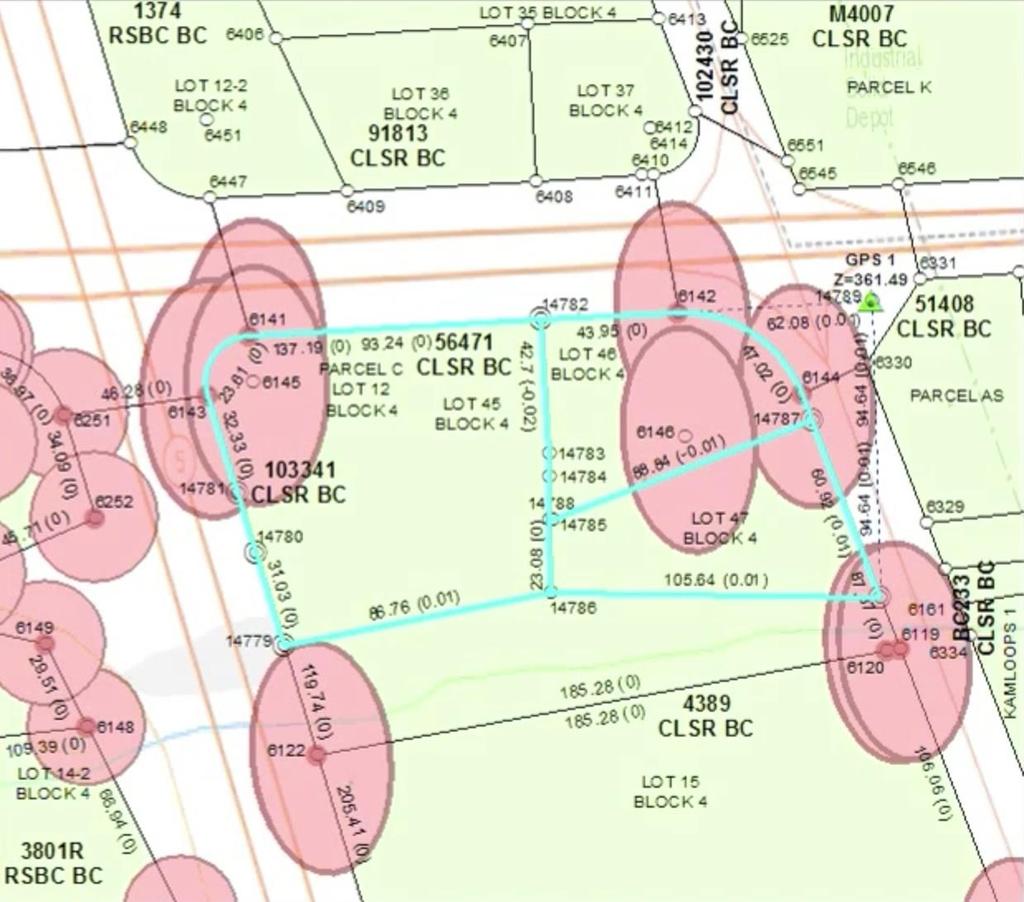
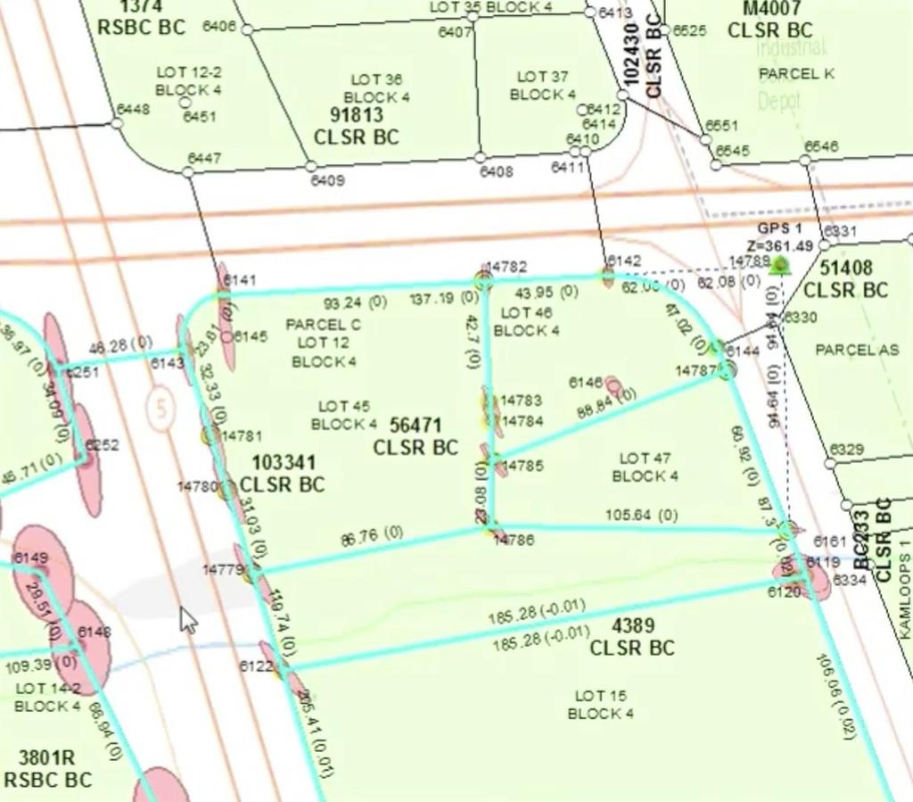
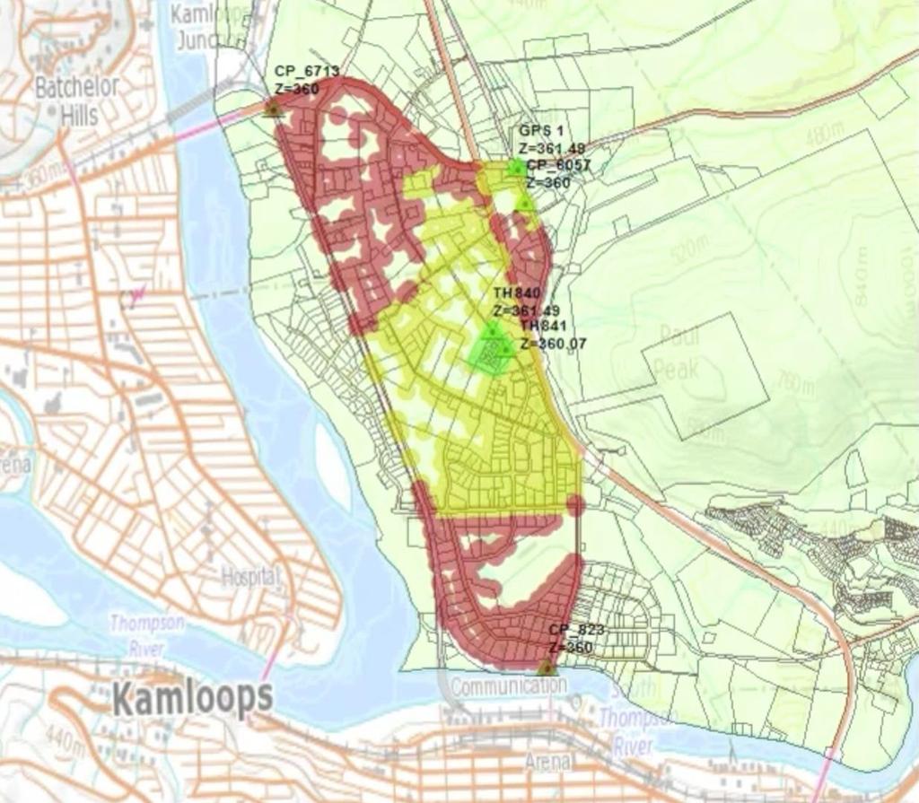
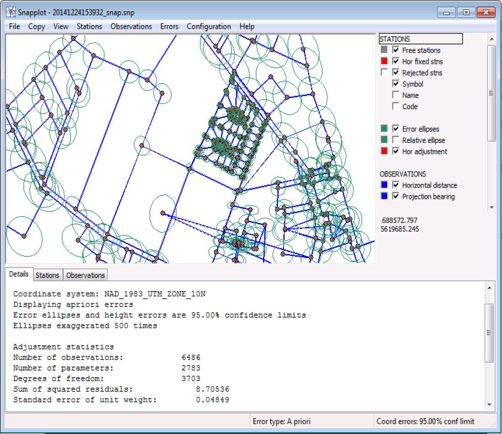
44 Large Scale Readjustment Collect real world positions of corners - Survey grade GPS (PPP / RTN) - Photo-recognizable control - From high resolution aerial imagery Use metadata to readjust area - Control, measurements, relative weights, interconnectivity Accept or reject new adjustment

45 Demo Review of the Capture> Join> Adjust Methodology
46 Common Parcel Editor Tools
47 Modify/Update Parcel Editor Tools Parcel Maintenance Tools Includes tools like: Parcel Division, Parcel Remainder, Parcel Merge Parent parcels become historic automatically Historic parcels are not deleted (user manages deletion of parcels) Construction Tools (Construct from Parent) Includes tools like: Breakline Tool, Create Parallel Offset Allows you to build new parcels based on existing parcel lines
48 Demo Using Common Parcel Editor Tools to Maintain the Parcel Fabric
49 Esri Canada Approach to Implementing Parcel Editing in ArcGIS
50 Esri Canada Approach Readiness Review A review of your current parcel mapping data Quantify the effort to make your data Parcel Fabric ready Understanding the benefits of the Parcel Fabric Model Data Migration Workshop(s) Fabric Maintenance Workshop(s) Implementation Support Data migration is about half the effort of a Parcel Mapping project Discussion of best practices for a successful data migration Map current parcel data into the parcel fabric model A review of the various out of the box parcel editor tools An understanding of how these tools can be used to complete end to end parcel mapping workflows Ongoing operations support as your staff learns to work with the Esri Parcel Mapping Solution
51 Canadian Parcel Data Model Standard Parcel Model for Canada Standard parcel editing model Standard parcel publishing model Leverages LGIM parcel model Canadian-izes survey legal descriptions Optional parcel dimension annotation First implementation in Oxford County Survey, ownership, assessment and easement parcels Condominium units as spatial entities Survey plan image mosaic
52 Canadian Parcel Data Model Many types of parcels Ownership, assessment, survey, easement, subsurface, zoning, lease
53 Canadian Parcel Data Model
54 Benefits to the Esri Canada Approach Lowers the risk of implementation Experienced implementation team - Subject matter expertise - Data migration experience - Deep product knowledge - Custom training solutions High quality Parcel Fabric The Canadian Parcel Data Model - Pre-configured parcel types, attributes, domains, and subtypes - Pre-configured display and symbology
55 Final Thoughts
56 Opportunities for engagement Our goal is to make you successful in your parcel mapping modernization There are varying levels of engagement: - Download the CPDM and implement the Parcel Mapping Solution yourself - Complete a Readiness Review with Esri Canada, then proceed with the Parcel Mapping implementation internally - Esri Canada can assist with the full implementation Different options depending on your needs Our recommendation: A readiness review on site will help position you for a successful implementation this is a great first step!
57 Final Thoughts There is an increasing demand for Parcel Mapping and a need for mapping modernization Capture> Join> Adjust methodology sets the ArcGIS Parcel Editing system apart from other systems Don t underestimate the complexity of migrating data into the Parcel Fabric help is available Experienced team of Parcel Mapping consultants on staff can offer guidance and expertise at various stages of a Parcel Editing implementation reach out to us!

58 Questions?
59 2016 Esri Canada Limited. All rights reserved. Trademarks provided under license from Environmental Systems Research Institute, Inc. Other product and company names mentioned herein may be trademarks or registered trademarks of their respective owners. Errors and omissions excepted.


60
Editing & Maintaining Parcels with ArcMap. Christine Leslie Amy Andis
 Editing & Maintaining Parcels with ArcMap Christine Leslie Amy Andis What to expect An introduction to the parcel fabric A detailed explanation of the parcel fabric data model General editing techniques
Advanced Parcel Editing. Amy Andis Tim Hodson
 Advanced Parcel Editing Amy Andis Tim Hodson Overview What to expect in this technical workshop Review of the Parcel Fabric Data Model Advanced Tips and tricks for Parcel entry Assessing Quality of Parcel
Introduction to Geodatabase and Spatial Management in ArcGIS. Craig Gillgrass Esri
 Introduction to Geodatabase and Spatial Management in ArcGIS Craig Gillgrass Esri Session Path The Geodatabase - What is it? - Why use it? - What types are there? - What can I do with it? Query Layers
Editing Parcel Fabrics Tutorial
 Editing Parcel Fabrics Tutorial Copyright 1995-2010 Esri All rights reserved. Table of Contents Tutorial: Getting started with parcel fabric editing...................... 3 Tutorial: Creating new parcels
Migrating Data to the Parcel Fabric. Christine Leslie Amir Bar-Maor
 Migrating Data to the Parcel Fabric Christine Leslie Amir Bar-Maor What is a parcel fabric? Dataset of related feature classes and tables - Polygons, lines, points, plans, etc. - Predefined system attributes
ArcGIS Apps for the Mobile Worker. Presented by: Sue Enyedy-Goldner
 ArcGIS Apps for the Mobile Worker Presented by: Sue Enyedy-Goldner Agenda 1. Overview of ArcGIS apps for mobile workflows 2. Considerations for configuring the best app for your workflow 3. Configuration
ArcGIS Apps for the Mobile Worker. Presented by: Sue Enyedy-Goldner
 ArcGIS Apps for the Mobile Worker Presented by: Sue Enyedy-Goldner Agenda 1. Overview of ArcGIS apps for mobile workflows 2. Considerations for configuring the best app for your workflow 3. Configuration
ArcGIS Apps for the Mobile Worker. Presented by: Sue Enyedy-Goldner
 ArcGIS Apps for the Mobile Worker Presented by: Sue Enyedy-Goldner Agenda 1. Overview of ArcGIS apps for mobile workflows 2. Considerations for configuring the best app for your workflow 3. Configuration
ArcGIS Pro: What s New in Editing and Data Management
 Federal GIS Conference February 9 10, 2015 Washington, DC ArcGIS Pro: What s New in Editing and Data Management Robert LeClair ArcGIS Pro Overview Esri FedUC 2015 Technical Workshop ArcGIS Pro: What's
Meeting Date: October 24, 2018
 Town of Moraga Ordinances, Resolutions, Requests for Action Agenda Item 11. A. 1 2 3 4 5 6 7 8 9 10 11 12 13 14 15 16 17 18 21 22 23 24 32 37 38 Meeting Date: October 24, 2018 TOWN OF MORAGA STAFF REPORT_
CONCOCTING A GIS. Designing a Geodatabase Optimized for Data Maintenance and Map Production
 CONCOCTING A GIS Designing a Geodatabase Optimized for Data Maintenance and Map Production Jim Isbell Engineering Tech. II Kern County Assessor s Office KERN COUNTY STATISTICS Size of Kern County 8,162
ArcGIS Hub: Open data best practices. Graham Hudgins, esri product engineer
 ArcGIS Hub: Open data best practices Graham Hudgins, esri product engineer Agenda Overview of open data in the ArcGIS Hub Example sites - Hubs Around the World Storymap Making a good site map Preparing
Facilities Management Data Input, Editing and Management. Adrien Litton
 Facilities Management Data Input, Editing and Management Adrien Litton Overview What is FM in GIS? Data input Data editing Data management Supporting the Real Property Life-Cycle GIS Integrates the Facility
OPERATIONS IMAGE SERVICE. Alyssa Geyer & Erin Ukestad April 21, 2016
 OPERATIONS IMAGE SERVICE Alyssa Geyer & Erin Ukestad April 21, 2016 Purpose To explore the challenges and successes of the effort that the Tobin Data division of P2 Energy Solutions has undertaken to migrate
ArcMap Editing Tips and Tricks. Sean Jones
 ArcMap Editing Tips and Tricks Sean Jones Overview Topics - Tuning your editing map - Creating features - Editing features and attributes - Aligning and editing coincident features - Addins Format - Software
ArcGIS Pro Editing: An Introduction. Jennifer Cadkin & Phil Sanchez
 ArcGIS Pro Editing: An Introduction Jennifer Cadkin & Phil Sanchez See Us Here WORKSHOP ArcGIS Pro Editing: An Introduction LOCATION SDCC - Ballroom 20 D TIME FRAME Thursday 10:00 11:00 ArcGIS Pro: 3D
May 2013 Oracle Spatial and Graph User Conference
 May 2013 Oracle Spatial and Graph User Conference May 22, 2013 Ronald Reagan Building and International Trade Center Washington, DC USA Paul Calhoun & Vince Smith GIS Systems Analyst City Of Virginia Beach
The What, Why, Who and How of Where: Building a Portal for Geospatial Data. Alan Darnell Director, Scholars Portal
 The What, Why, Who and How of Where: Building a Portal for Geospatial Data Alan Darnell Director, Scholars Portal What? Scholars GeoPortal Beta release Fall 2011 Production release March 2012 OLITA Award
Standardized Data Production Strategies Across Your Enterprise
 Federal GIS Conference February 9 10, 2015 Washington, DC Standardized Data Production Strategies Across Your Enterprise Amber Bethell Sherry Fagin Authoritative content producers Knowledge Workers Executive
ArcGIS Pro Editing. Jennifer Cadkin & Phil Sanchez
 ArcGIS Pro Editing Jennifer Cadkin & Phil Sanchez ArcGIS Pro Editing Overview Provides tools that allow you to maintain, update, and create new data - Modifying geometry, drawing new features - Entering
What's New in ArcGIS 9.2 Service Packs
 What's New in ArcGIS 9.2 Service Packs 18 July 2007 Updated for Service Pack 3 This document describes the main enhancements to 9.2 added by the service packs. It does not cover the bug fixes and quality
City of Kitchener Evolution of 3D Modeling. Presented by: Mike Elliott Adam Clark
 City of Kitchener Evolution of 3D Modeling Presented by: Mike Elliott Adam Clark Project Description There has been a building interest from the public and staff in exploring 3D mapping or modeling There
CIP Standards Development Overview
 CIP Standards Development Overview CSSDTO706 Meeting with FERC Technical Staff July 28, 2011 Objectives Historical Timeline CIP-002-4 CIP-005-4 CIP Version 5 2 Project 2008-06 Overview FERC Order 706 SDT
Technology for Cadastral Applications. John R. Hacker, Jr. Marketing Manager Geospatial Applications
 Technology for Cadastral Applications John R. Hacker, Jr. Marketing Manager Geospatial Applications Agenda Cadastral Mapping Issues Precision and Accuracy Data Creation Data Management Data Publishing
Autodesk Utility Design and Your GIS
 UT4523-P Autodesk Utility Design and Your GIS Prashant Srivastav Quality Assurance Lead, Utilities Co Speakers: Jeff Saunders, Carsten Hess The Power Track Utility Design Power Track at a glance... and
13.f Toronto Catholic District School Board's IT Strategic Review - Draft Executive Summary (Refer 8b)
") AGENDA ADDENDU TE REGULAR EETING OF TE AUDIT COITTEE COITTEE PUBLIC SESSION Tuesday, June 6, 2017 6:30 P.. Pages 13. Staff Reports 13.f Toronto Catholic District School Board's IT Strategic Review - Draft
AGENDA ADDENDU TE REGULAR EETING OF TE AUDIT COITTEE COITTEE PUBLIC SESSION Tuesday, June 6, 2017 6:30 P.. Pages 13. Staff Reports 13.f Toronto Catholic District School Board's IT Strategic Review - Draft
ArcGIS Data Reviewer: Ensuring Accurate and Complete Data to Meet Your Mission. John Grammer Kevin Pusey
 ArcGIS Data Reviewer: Ensuring Accurate and Complete Data to Meet Your Mission John Grammer Kevin Pusey Workshop agenda Defining data quality What is ArcGIS Data Reviewer? Automated review Semi-automated
Esri Best Practices: QA/QC For Your Geodata. Michelle Johnson & Chandan Banerjee
 Esri Best Practices: QA/QC For Your Geodata Michelle Johnson & Chandan Banerjee Overview Understand Document Implement Understanding QA/QC Understanding QA/QC Fit For Use - support your GIS applications?
Enterprise GIS for Managing Reservation Land
 Enterprise GIS for Managing Reservation Land Beckie Howell GIS Manager Agua Caliente Band of Cahuilla Indians ESRI UC 2014 Tribal Indigenous GIS Track Empowering Tribal Governments with Enterprise GIS
Intelligent Enterprise meets Science of Where. Anand Raisinghani Head Platform & Data Management SAP India 10 September, 2018
 Intelligent Enterprise meets Science of Where Anand Raisinghani Head Platform & Data Management SAP India 10 September, 2018 Value The Esri & SAP journey Customer Impact Innovation Track Record Customer
What s New in ArcGIS Server 10
 What s New in ArcGIS Server 10 Derek Law ArcGIS Server Product Management What s s new in ArcGIS Server 10? Agenda Highlights: Enhanced Web mapping More powerful server-based analysis Geo-collaboration
Troubleshooting Performance Issues with Enterprise Geodatabases. Ben Lin, Nana Dei, Jim McAbee
 Troubleshooting Performance Issues with Enterprise Geodatabases Ben Lin, Nana Dei, Jim McAbee blin@esri.com ndei@esri.com jmcabee@esri.com Workshop Agenda Performance Troubleshooting (Then & Now) Real-World
Data Governance Quick Start
 Service Offering Data Governance Quick Start Congratulations! You ve been named the Data Governance Leader Now What? Benefits Accelerate the initiation of your Data Governance program with an industry
Challenges that can be overcome with the aid of ESA GIM Click to edit Master text styles
 Click to edit Agenda Master By: Egyptian Survey Authority Geographic Information Management System Kholoud Saad Salama Egypt (ESA GIM) 1 About Egyptian Survey Authority Third ESA GIM level Business Requirements
Collector for ArcGIS
 Collector for ArcGIS Field GIS Taking GIS Beyond the Office Collecting Data Reporting Observations Managing Work Connecting the Field with the Enterprise Field Mobility Solutions Improve accuracy and currency
Kane County GIS-Technologies Management Solutions. DGN to SDE and Back Again
 Kane County Management Solutions nicoskithomas@co.kane.il.us 1 In the Beginning DGN Kane County, Illinois Supervisor of Assessments Bears Win Superbowl XX Intergraph IGDS Software Graphic Workstations
LOCAL STREETS AND THE ARNOLD INITIATIVE
 LOCAL STREETS AND THE ARNOLD INITIATIVE Jenn Sylvester, Mapping Branch Team Lead Transportation Planning & Programming Division (TPP) GIS-T Symposium Des Moines, IA Key Terms 1 2 3 ARNOLD FC Streets Local
The State of Missouri
 NASCIO 2013 Recognition Awards Nomination The State of Missouri Hazardous Substance Site Locator Project Initiation and Completion Dates: 04/29/13 to 12/01/13 Category: Digital Government: Government to
Introducing ArcScan for ArcGIS
 Introducing ArcScan for ArcGIS An ESRI White Paper August 2003 ESRI 380 New York St., Redlands, CA 92373-8100, USA TEL 909-793-2853 FAX 909-793-5953 E-MAIL info@esri.com WEB www.esri.com Copyright 2003
Accelerate Your Enterprise Private Cloud Initiative
 Cisco Cloud Comprehensive, enterprise cloud enablement services help you realize a secure, agile, and highly automated infrastructure-as-a-service (IaaS) environment for cost-effective, rapid IT service
Building Information Modeling
 Chapter Building Information Modeling 1 Building information modeling (BIM) is an integrated workflow built on coordinated, reliable information about a project from design through construction and into
Working with Feature Layers. Russell Brennan Gary MacDougall
 Working with Feature Layers Russell Brennan Gary MacDougall Working with Feature Layers Session will focus on feature access and editing Highlight new features added over the last few releases Agenda Introduction
Anton van Wyk 1Spatial Australia Pty ltd Country Manager Spatial Data Infrastructure
 Anton van Wyk 1Spatial Australia Pty ltd Country Manager Anton.vanWyk@1spatial.com Spatial Data Infrastructure Industry Sectors Transportation Spatial Data Infrastructure Telecommunications Utilities Mapping
What s New in Imagery in ArcGIS. Presented by: Christopher Patterson Date: October 18, 2017
 What s New in Imagery in ArcGIS Presented by: Christopher Patterson Date: October 18, 2017 Imagery in ArcGIS Advancing 2010 Stretch, Extract Bands Clip, Mask Reproject, Orthorectify, Pan Sharpen Vegetation
Slide 1. Advanced Cartography in ArcGIS. Robert Jensen Edie Punt. Technical Workshops
 Slide 1 Technical Workshops Advanced Cartography in ArcGIS Robert Jensen Edie Punt Slide 2 Overview Using representations to manage symbology Solving graphic conflicts Geoprocessing for cartography in
ArcGIS Desktop The Road Ahead. Amadea Azerki
 ArcGIS Desktop The Road Ahead Amadea Azerki Agenda An Overview of ArcGIS 10 Desktop Enhancements User Interface Mapping Editing Analysis Sharing Q & A ArcGIS 10 Overview Focuses on Usability and Productivity
Integrated Cadastral Fabric
 Integrated Cadastral Fabric Specification and Standard Version 1.0.0 2006-11-30 1 Integrated Cadastral Fabric - Specification and Standard Revision Control Revision Number Revised By Revision Details Approved
A Strategy and Vision for Enterprise 3D GIS. B r o o k s P a t r i c k A c c o u n t E x e c u t i v e b p a t r i c e s r i.
 A Strategy and Vision for Enterprise 3D GIS B r o o k s P a t r i c k A c c o u n t E x e c u t i v e b p a t r i c k @ e s r i. c o m Understanding where things are, and why, is essential for rational
Designing and Using Basemaps. Jennifer Hughey
 Designing and Using Basemaps Jennifer Hughey Agenda The ArcGIS System Basemaps are a key component of your system Cartographic design considerations Using basemap layers in ArcMap Best practices for designing
Utility Network Management in ArcGIS: Migrating Your Data to the Utility Network. John Alsup & John Long
 Utility Network Management in ArcGIS: Migrating Your Data to the Utility Network John Alsup & John Long Presentation Outline Utility Network Preparation - Migration Patterns - Understanding the Asset Package
Digital Softcopy Photogrammetry
 LLP Erasmus IP EPOCHE 2013 Thassos Island, Greece, 2-16 June 2013 Digital Softcopy Photogrammetry Prof. Levente DIMEN The 1 Decembrie 1918 University of Alba Iulia, Romania GENERAL CONTEXT In the last
Dell helps you simplify IT
 Dell helps you simplify IT Workshops the first step. Reduce desktop and data center complexity. Improve productivity. Innovate. Dell IT Consulting Services New Edition 2011 Introduction Are you spending
Redistricting and Geographic Deployment at the Ottawa Police Service Esri Canada User Conference Ottawa October 12, 2017
 Redistricting and Geographic Deployment at the Ottawa Police Service Esri Canada User Conference Ottawa October 12, 2017 Introduction Alyson Yaraskovitch, B.A., M.A. Crime Intelligence Analyst Ottawa Police
Successfully Filing Broadband Deployment Data with USAC
 Successfully Filing Broadband Deployment Data with USAC Meet our Team Alex Wolff Manager of Project and Product Management alex.wolff@usac.org Bill Johnson Director of Geographic Information Systems (GIS)
Using Parcel Administrator at KGIS & Hamilton County, TN to Track and Manage Parcel Transactions in GIS and CAMA SERUG Conference May 5, 2015
 Using Parcel Administrator at KGIS & Hamilton County, TN to Track and Manage Parcel Transactions in GIS and CAMA 2015 SERUG Conference May 5, 2015 Achieving Integration Without Hurting Yourself 2015 SERUG
Presented By: Jack L. Avis, PLS, GISP
 Pima County s Parcel Fabric Development Presented By: Jack L. Avis, PLS, GISP Migrating CAD Parcels to the Parcel Fabric Research current use of CAD data and its GIS usage Requires a close examination
Pave the way: Build a value driven SAP GRC roadmap March 2015
 www.pwc.be/erp Pave the way: Build a value driven SAP GRC roadmap March 2015 Agenda Introduction Measuring GRC Progression & Benchmarking GRC Program Roadmap Building a Business Case 2 Introduction Pave
IS4H TOOLKIT TOOL: Workshop on Developing a National ehealth Strategy (Workshop Template)
") IS4H TOOLKIT TOOL: Workshop on Developing a National ehealth Strategy (Workshop Template) Department of Evidence and Intelligence for Action in Health PAHO/WHO Workshop on Developing a National ehealth
IS4H TOOLKIT TOOL: Workshop on Developing a National ehealth Strategy (Workshop Template) Department of Evidence and Intelligence for Action in Health PAHO/WHO Workshop on Developing a National ehealth
Investigation of Routing Options for the Nova Scotia Road Network (NSRN)
") Nova Scotia Investigation of Routing Options for the Nova Scotia Road Network (NSRN) 2007 GIS T Conference Nashville, TN March 25 28, 2007 David Loukes, P.Eng. Vice President 1 Nova Scotia Opus International
Nova Scotia Investigation of Routing Options for the Nova Scotia Road Network (NSRN) 2007 GIS T Conference Nashville, TN March 25 28, 2007 David Loukes, P.Eng. Vice President 1 Nova Scotia Opus International
Creating and Maintaining Your 3D Basemap. Brian Sims Dan Hedges Gert van Maren
 Creating and Maintaining Your 3D Basemap Brian Sims Dan Hedges Gert van Maren Complementary Resource Email (no marketing) A copy of the presentation Links to today s web demos Links to training materials
Topology in the Geodatabase: An Introduction
 Topology in the Geodatabase: An Introduction Colin Zwicker Erik Hoel ESRI Super Secret Topology Laboratory, May 2016 Agenda ArcGIS Topology defined Validating a topology Editing a topology Geoprocessing
Cisco Director Class SAN Planning and Design Service
 Cisco Director Class SAN Planning and Design Service Rapidly Plan and Deploy a Cisco Director Class MDS Solution for More Efficient Storage Networking Service Overview Cisco s intelligent storage networking
STATEWIDE CENTERLINE INITIATIVE EDITED: MAY 17, 2013
 STATEWIDE CENTERLINE INITIATIVE EDITED: MAY 17, 2013 WHAT IS THE CENTERLINE INITIATIVE? The Centerline Initiative is a joint effort between the Minnesota Department of Transportation (MnDOT), Minnesota
ArcGIS Solutions for Community Resilience. Matthew S Deal
 ArcGIS Solutions for Community Resilience Matthew S Deal Solutions Overview Leverage hundreds of ready-to-use maps, apps, and platform configurations to meet your needs, delivering innovation and best
Innovative Integrations Boost Designing with BIM
 Hong Kong Housing Authority Project: Bridging the Gaps with our Core Values Successful Transformation of Revit Model to Enable Civil 3D/GIS/Revit Integration and Lighting Simulation & Rendering Location:
Avoid a DCIM Procurement Disaster
 Avoid a DCIM Procurement Disaster Matt Stansberry Senior Director, Uptime Institute 7 December 2016 2016 Uptime Institute, LLC Many organizations struggle with DCIM decisions Process takes too long, software
Esri s ArcGIS Enterprise. Today s Topics. ArcGIS Enterprise. IT4GIS Keith T. Weber, GISP GIS Director ISU GIS Training and Research Center
 Esri s ArcGIS Enterprise IT4GIS Keith T. Weber, GISP GIS Director ISU GIS Training and Research Center Today s Topics Part 1: ArcGIS Enterprise architecture Part 2: Storing and serving data for the enterprise
CITY COUNCIL AGENDA REPORT
 CITY COUNCIL AGENDA REPORT Subject: AUMA RESOLUTION BROADBAND INTERNET Recommendation(s) That the AUMA Broadband Resolution 2016, provided as Attachment 1 to the May 24, 2016 report entitled AUMA Resolution
Six Sigma in the datacenter drives a zero-defects culture
 Six Sigma in the datacenter drives a zero-defects culture Situation Like many IT organizations, Microsoft IT wants to keep its global infrastructure available at all times. Scope, scale, and an environment
ENGRG 59910: Introduction to GIS
 ENGRG 59910: Introduction to GIS Lecture 05: GIS and Databases Basics Acknowledgment: Michael Piasecki Where are we now? Basic geographic concepts Introduction to GIS, coordinate system, projection, datum
Developing Add-Ins for ArcGIS Pro (.NET) Toronto Esri Canada UC Presented by: Gandhar Wazalwar & Kern Ranjitsingh October 11, 2018
 Toronto Esri Canada UC Presented by: Gandhar Wazalwar & Kern Ranjitsingh October 11, 2018") Developing Add-Ins for ArcGIS Pro (.NET) Toronto Esri Canada UC Presented by: Gandhar Wazalwar & Kern Ranjitsingh October 11, 2018 Esri Canada Professional Services Project services Implementation services
Developing Add-Ins for ArcGIS Pro (.NET) Toronto Esri Canada UC Presented by: Gandhar Wazalwar & Kern Ranjitsingh October 11, 2018 Esri Canada Professional Services Project services Implementation services
USING GIS TO TRANSFORM YOUR ORGANIZATION. Reengineering a GIS Department. TRA Adopts a Business Solution Approach ESRI UC 2017
 USING GIS TO TRANSFORM YOUR ORGANIZATION Reengineering a GIS Department TRA Adopts a Business Solution Approach ESRI UC 2017 Glenn Clingenpeel, Bob Ayensu Outline 1. History of TRA 2. Overview 3. Approach
NEW GeoWarehouse General Release User Guide
 NEW GeoWarehouse General Release User Guide 1 Table of Content Part I.- Search Options 1. Changing Location to another Land Registry Office (LRO). 2. Finding the LRO where a city/town is located in. 3.
Understanding ArcGIS Pipeline Referencing for Vertically Integrated Gas Companies. GeoConX 2017 September 7, 2017
 Understanding ArcGIS Pipeline Referencing for Vertically Integrated Gas Companies GeoConX 2017 September 7, 2017 The Asset Intelligence Imperative GOAL The necessity to learn ever more, in as close to
TRANSFORMING WEST MIDLANDS POLICE A BOLD NEW MODEL FOR POLICING
 TRANSFORMING WEST MIDLANDS POLICE A BOLD NEW MODEL FOR POLICING In 2014, West Midlands Police (WMP) committed to a striking transformation programme that would help the force meet current and future policing
Parcel QA/QC: Video Script. 1. Introduction 1
 1. Introduction 1 Hi! It s been a while since you heard from us. I am Ara Erickson with the University of Washington. We are taking this opportunity to do a quick introduction and explain a few things
This guide will tell you all you need to know about the new Front Desk application which can be found on the main Peoria County GIS website.
 New Front Desk Quick Guide, 2014 At a First Glance This guide will tell you all you need to know about the new Front Desk application which can be found on the main Peoria County GIS website. When you
Linus L. Smith, GIS Supervisor, Engineering Public Works Department, City of Winfield, Kansas
 Challenges in Developing a City GIS Wastewater Geo Database System Linus L. Smith, GIS Supervisor, Engineering Public Works Department, City of Winfield, Kansas OVERVIEW The City of Winfield Kansas recognized
Collector for ArcGIS. Paul Barker Bert Yagrich
 Collector for ArcGIS Paul Barker Bert Yagrich Agenda What are we going to cover today? ArcGIS as a platform for data collection Device strategy and field data collection Collector for ArcGIS an overview
CHAIR AND MEMBERS CIVIC WORKS COMMITTEE MEETING ON NOVEMBER 29, 2016
 TO: FROM: SUBJECT: CHAIR AND MEMBERS CIVIC WORKS COMMITTEE MEETING ON NOVEMBER 29, 2016 KELLY SCHERR, P.ENG., MBA, FEC MANAGING DIRECTOR ENVIRONMENTAL & ENGINEERING SERVICES AND CITY ENGINEER SHIFT RAPID
Does Your Data Have Harmony. Dan Stone
 Does Your Data Have Harmony Dan Stone Agenda Introduction Configuration Patterns Implementation Approaches Your Feedback ArcGIS for Local Government Esri solutions for local government customers Series
Configuring the ArcGIS for Local Government Solution
 Configuring the ArcGIS for Local Government Solution Lindsay Thomas Steve Grise Scott Oppmann Esri UC 2015 Technical Workshop Agenda Introduction Configuration Patterns Implementation Approaches Your Feedback
Compass INSPIRE Services. Compass INSPIRE Services. White Paper Compass Informatics Limited Block 8, Blackrock Business
 Compass INSPIRE Services White Paper 2010 Compass INSPIRE Services Compass Informatics Limited Block 8, Blackrock Business Park, Carysfort Avenue, Blackrock, County Dublin, Ireland Contact Us: +353 1 2104580
Emergence of Business Continuity to Ensure Business and IT Operations. Solutions to successfully meet the requirements of business continuity.
 Emergence of Business Continuity to Ensure Business and IT Operations Solutions to successfully meet the requirements of business continuity. 2 3 4 5 Introduction Use of Virtualization Technology as a
Modernizing California State Highway Right of Way Records with GIS. Caltrans District 4 Oakland, CA
 Modernizing California State Highway Right of Way Records with GIS Caltrans District 4 Oakland, CA About Us Kirsten Lawrence (GISP), Senior Geospatial Analyst on staff augmentation contract with Caltrans
Make Your GIS Work for You, First Step: Data Quality
 Make Your GIS Work for You, First Step: Data Quality Presented by: Scott Sumners, GIS Manager, City of Brentwood James McCord, GIS Analyst, City of Brentwood Gerardo Boquin, GISP /CH2M Brentwood GIS CAD
hereby recognizes that Timotej Verbovsek has successfully completed the web course 3D Analysis of Surfaces and Features Using ArcGIS 10
 3D Analysis of Surfaces and Features Using ArcGIS 10 Completed on September 5, 2012 3D Visualization Techniques Using ArcGIS 10 Completed on November 19, 2011 Basics of Map Projections (for ArcGIS 10)
Peoria County Front Desk Map Application
 Peoria County Front Desk Map Application Quick Guide, 2017 At a First Glance This guide will tell users all they need to know about the Peoria County Front Desk application which can be found on the Peoria
2. POINT CLOUD DATA PROCESSING
 Point Cloud Generation from suas-mounted iphone Imagery: Performance Analysis A. D. Ladai, J. Miller Towill, Inc., 2300 Clayton Road, Suite 1200, Concord, CA 94520-2176, USA - (andras.ladai, jeffrey.miller)@towill.com
PI Integrator for Esri ArcGIS: A Journey Through Time and Space
 PI Integrator for Esri ArcGIS: A Journey Through Time and Space Presented by Vadim Fedorov, Sr. Systems Engineer Elizabeth Ammarell, Product Manager The Past: Where We Started 2 Two companies, one vision
Building Strategies & Sustainability
 Building Strategies & Sustainability ENERGY-EFFICIENT SOLUTIONS FOR NEW CONSTRUCTION & RETROFITS 03 Rate Card & Planner Building Strategies & Sustainability is an industry leading publication tackling
Creating a 3D GIS Program in the City of Cambridge
 Creating a 3D GIS Program in the City of Cambridge JEFF AMERO CITY OF CAMBRIDGE ESRI User Conference, San Diego, CA July 13, 2017 Presentation Overview -Bringing 3D GIS to Cambridge -Components of the
Energy Step Code Implementation Strategy. March 26, 2018
 Energy Step Code Implementation Strategy March 26, 2018 About the BC Energy Step Code Climate Leadership Plan call for: Net zero energy ready buildings by 2032; Development of the Energy Step Code to get
Securing Your Digital Transformation
 Securing Your Digital Transformation Security Consulting Managed Security Leveraging experienced, senior experts to help define and communicate risk and security program strategy using real-world data,
PWA GIS. Minnesota Department of Transportation (Mn/DOT) Cadastral and Right of Way Data Sharing Pilot Project. Phase 1 and Phase 2 Summary Report
 Cadastral and Right of Way Data Sharing Pilot Project. Phase 1 and Phase 2 Summary Report") Minnesota Department of Transportation (Mn/DOT) Cadastral and Right of Way Data Sharing Pilot Project Phase and Phase Summary Report December, 7 Pro-West & Associates, Inc. Geographic Information System
Minnesota Department of Transportation (Mn/DOT) Cadastral and Right of Way Data Sharing Pilot Project Phase and Phase Summary Report December, 7 Pro-West & Associates, Inc. Geographic Information System
ArcGIS 9. Maplex Tutorial
 ArcGIS 9 Maplex Tutorial Copyright 004 006 ESRI All rights reserved. Printed in the United States of America. The information contained in this document is the exclusive property of ESRI. This work is
A New Dimension to Land Development and Subdivision Design: Application of AutoCAD Civil 3D
 A New Dimension to Land Development and Subdivision Design: Application of AutoCAD Civil 3D Tarig Ali College of Engineering and Computer Science University of Central Florida Orlando, Florida taali@mail.ucf.edu
Cloud solution consultant
 Cloud solution consultant Role brief Directorate Jisc technologies Base location Harwell or Bristol Grade B Job level 18 Job family Professional services Date 23/10/2017 Reports to Cloud services group
Test Georeferencing Transformations
 Test Georeferencing s By Mike Price, Entrada/San Juan, Inc. What you will need ArcGIS Pro 2.1 license ArcGIS Online for organizations account Sample dataset downloaded from ArcUser website An unzipping
Esri and MarkLogic: Location Analytics, Multi-Model Data
 Esri and MarkLogic: Location Analytics, Multi-Model Data Ben Conklin, Industry Manager, Defense, Intel and National Security, Esri Anthony Roach, Product Manager, MarkLogic James Kerr, Technical Director,