Physical Geography Lab Activity #08
|
|
|
- Moses Cunningham
- 5 years ago
- Views:
Transcription
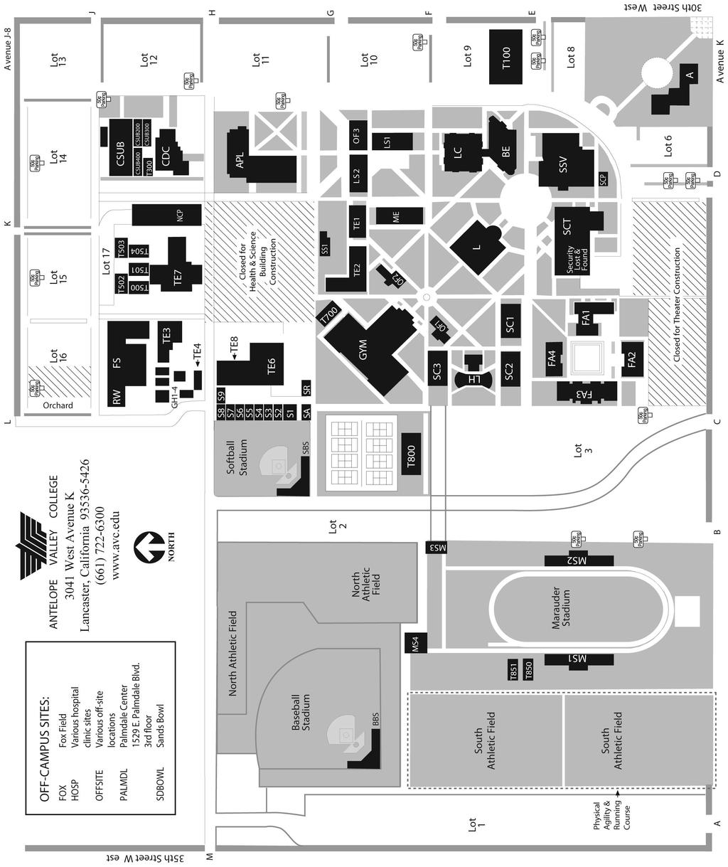
1 Physical Geography Lab Activity #08 Due date Name Using a compass COR Objective Introduction The compass is undeniably a valuable tool in finding your way, but it is also useless if you don t know how to actually use it.a needle pointing to north is only one tool in successfully finding your way out of the wilderness. This lab will introduce you to using the compass in the real world Cardinal Direction and Azimuth We know that the compass points north, but cardinal direction is more than the letter N. We divide the round compass rose into sixteen different directions. North is at the top, east points to the right, south to the bottom, and west to the left. In between two main directions like north and west, we have northwest (NW). In between NW and west we have west-northwest (WNW) and in between NW and N we have north-northwest (NNW). 1. Fill in the missing directions on the compass rose below: 65
2 Azimuth is similar to cardinal direction, but way more useful in applying to navigation with a map and compass. Rather than use north, south, etc. azimuth relies on degrees. North corresponds with 0, east is 90, south is 180, and so on. When reporting azimuth we always use three digits. Add two zeroes to the front if the number is below ten and one zero if it is below 100 (e.g. 15 would be 015 ). 2. Fill in the missing azimuths on the compass rose below: 8.3. Pacing You now understand direction, but the other crucial component in using a compass is distance. Measuring long distances in the field is not easy. Knowing your pacing distance will allow you to have a pretty good idea of how far you ve gone without having to stretch a tape measure over rocky terrain. Pacing distance is the distance between every other step. 1. Walk at a normal pace for a distance of 100 feet. Count every other step. 2. Write down the number you counted here. 3. Do it again. Write the number here. 4. Do it one more time. Write the number here. 66
3 5. Take the average of the three numbers from above. Your pace is paces per 100ft 6. Now divide 100ft/ paces. Your pace is ft/pace. This final number will be very important for this and other labs. Commit it to memory Practicing with the compass To use a compass to find an azimuth you simply do the following: Chose a specific object or landmark that is at least twenty feet away. Hold the compass flat in your hand. Any tilting can cause the needle to drag and give you the wrong direction. Also make sure you aren t wearing any jewelry or electronics that could cause the magnetic needle to be pulled away from north. Point the front of the compass at the object. Twist the compass housing (the part with the numbers) until the red arrow outline is directly underneath the red needle Read the number that is now lined up with the front of the compass. That is the azimuth of the object or landmark you are pointed towards. It sounds easy enough, but using a compass with confidence takes practice. That is what you will do now. 7. Find an object on campus that you can shoot an azimuth for. Write it here 8. Now walk to the object and shoot an azimuth back to where you were first standing. Write that new azimuth here. 9. Subtract the larger azimuth from the smaller. If you are using the compass properly, you should get a difference of exactly 180. Being off by a degree or two isn t a big deal, but if you are off by more than five degrees you need to try it again. 10. Repeat this with four more objects a. Azimuth, Back azimuth, Difference b. Azimuth, Back azimuth, Difference c. Azimuth, Back azimuth, Difference d. Azimuth, Back azimuth, Difference 67
4 8.5. Declination Declination refers to the difference between the geographic north pole, or true north, which is the one at the top of the globe, and the magnetic north pole which is where the north end of the magnetic field actually is. You need to correct for declination because the needle on your compass aligns with magnetic north and not the north arrow on your map. Not doing so can get you horribly lost when travelling over long distances. One way to check for magnetic declination is to compare a linear feature on the map with its magnetic azimuth. 11. Using your attached campus map find a nearby linear feature running northsouth. A sidewalk could work just fine. 12. Find the magnetic azimuth for that same feature with your compass. If the azimuth is to the west of north subtract that number from 360. If your azimuth is to the east of north, simply write down that number. Be sure to add the direction to your declination. 13. The declination on campus is. If you are using a declinated compass you can adjust the dial to correct for the local declination. The convenience of this is that you never have to think about declination again. If you are using a simple base plate compass you will need to make mathematic corrections to every azimuth you take. 68
5 69
6 8.6. Charting a compass course With your compass and knowledge of your pacing distance, you should be able to record a route that others can follow. Working in groups, first look at your campus map and try to visualize a twelve point course. Walk the course and record the azimuth, distance, and description of the objects you visit below. 14. Starting point: Azimuth Number of Paces Distance (ft) Description 15. Final point: 70
7 8.7. Following a compass course Have one member of your group rewrite the final course below, but do not write down the descriptions or the final point. Give this sheet to another group in your class. Each group will try to follow the other s routes and make it to the final point. When you are following another group s course, make sure to write down where you think the final point is. When you finish the course give this paper back to the original group. Did you make it to the right final point? If not, what went wrong? 16. Starting point: Azimuth Distance (ft) Number of Paces 17. Final point: End of Lab 8 71
Lesson 7 Determining Direction. Key Terms. azimuth back azimuth degree grid azimuth grid north magnetic azimuth magnetic north true north
 Lesson 7 Determining Direction U.S. ARMY Key Terms J R O T C azimuth back azimuth degree grid azimuth grid north magnetic azimuth magnetic north true north WHAT YOU WILL LEARN TO DO Calculate direction
FM CHAPTER 6 DIRECTION
 CHAPTER 6 DIRECTION Being in the right place at the prescribed time is necessary to successfully accomplish military missions. Direction plays an important role in a soldier's everyday life. It can be
LESSON 6: DETERMINING DIRECTION
 LESSON 6: DETERMINING DIRECTION PURPOSE Directions play an important role in everyday life. People oftentimes express them as right, left, straight ahead, and so forth; but then the question arises, to
6-1. METHODS OF EXPRESSING DIRECTION
 CHAPTER 6 DIRECTION Being in the right place at the prescribed time is necessary to successfully accomplish military missions. Direction plays an important role in a soldier's everyday life. It can be
Name: Pythagorean Theorem February 3, 2014
 1. John leaves school to go home. He walks 6 blocks North and then 8 blocks west. How far is John from the school? 5. A 26 foot long ladder is leaning up against a house with its base 10 feet away from
Objective- Students will be able to use the Order of Operations to evaluate algebraic expressions. Evaluating Algebraic Expressions
 Objective- Students will be able to use the Order of Operations to evaluate algebraic expressions. Evaluating Algebraic Expressions Variable is a letter or symbol that represents a number. Variable (algebraic)
TEST EXAM PART 2 INTERMEDIATE LAND NAVIGATION
 NAME DATE TEST EXAM PART 2 INTERMEDIATE LAND NAVIGATION 1. Knowing these four basic skills, it is impossible to be totally lost; what are they? a. Track Present Location / Determine Distance / Sense of
Lab 21.1 The Tangent Galvanometer
 Name School Date Lab 21.1 The Tangent Galvanometer Purpose To investigate the magnetic field at the center of a current-carrying loop of wire. To verify the right-hand rule for the field inside a current
Lesson 4: Angular measure and azimuths
 PRO TIPS: Map Reading Lesson 4: Angular measure and azimuths References: FM 21-25; FM 21-26; Map Lesson 4 in map section. Study assignment: read FM 21-25 Chapters 7 to 9, then go through this lesson and
Angle, symmetry and transformation
 Terms Illustrations Definition Acute angle An angle greater than 0 and less than 90. Alternate angles Where two straight lines are cut by a third, as in the diagrams, the angles d and f (also c and e)
GSN SunShot Procedures Using Internet Solar Position Calculator
 GSN SunShot Procedures Using Internet Solar Position Calculator Purpose: Determine astronomical (true) north for instrument orientation by observing the Sun s azimuth using a Theodolite and Sun Position
1.1. Driving Around Euclid. Goals. Launch 1.1
 1.1 Driving Around Euclid Goals Review the coordinate system Explore distances on a coordinate grid In this problem, students review the concept of the coordinate grid and are introduced to the idea of
UNIT 1 PLACE VALUE AND WHOLE NUMBERS
 UNIT 1 PLACE VALUE AND WHOLE NUMBERS INTRODUCTION We will begin our study of Arithmetic by learning about the number system we use today. The Base-10 Number System or Hindu-Arabic Numeral System began
BRx6 Sensor Calibration Using SurvCE/SurvPC
 OVERVIEW BRx6 Sensor Calibration Using SurvCE/SurvPC The BRx6 internal sensors (tilt, accelerometer and compass) must be calibrated in order to use the electronic bubble and tilted pole corrections in
Reconnaissance and Surveillance Leader s Course Map Reading self study worksheet (Tenino, Washington Map)
") Reconnaissance and Surveillance Leader s Course Map Reading self study worksheet (Tenino, Washington Map) General Knowledge 1. Name the five Basic Colors on a map and what they represent? 1. 2. 3. 4. 5.
Reconnaissance and Surveillance Leader s Course Map Reading self study worksheet (Tenino, Washington Map) General Knowledge 1. Name the five Basic Colors on a map and what they represent? 1. 2. 3. 4. 5.
Excel Basics Rice Digital Media Commons Guide Written for Microsoft Excel 2010 Windows Edition by Eric Miller
 Excel Basics Rice Digital Media Commons Guide Written for Microsoft Excel 2010 Windows Edition by Eric Miller Table of Contents Introduction!... 1 Part 1: Entering Data!... 2 1.a: Typing!... 2 1.b: Editing
Operation: a) Compass calibration mode 1.When battery is replaced,the device will enter into calibration mode.the LCD will display CAL, indicating the
 Compass calibration mode 1.When battery is replaced,the device will enter into calibration mode.the LCD will display CAL, indicating the") MULTIFUNCTIONS DIGITAL COMPASS USER MANUAL General description: Your digital compass is using the last electromagnetic sensing technology. It is also a combination of watch, stop-watch, and thermometer.
MULTIFUNCTIONS DIGITAL COMPASS USER MANUAL General description: Your digital compass is using the last electromagnetic sensing technology. It is also a combination of watch, stop-watch, and thermometer.
I CALCULATIONS WITHIN AN ATTRIBUTE TABLE
 Geology & Geophysics REU GPS/GIS 1-day workshop handout #4: Working with data in ArcGIS You will create a raster DEM by interpolating contour data, create a shaded relief image, and pull data out of the
Section 1.3 Adding Integers
 Section 1.3 Adding Integers Objectives In this section, you will learn to: To successfully complete this section, you need to understand: Represent integers as vectors. The integer number line (1.2) Add
Module 7 Defining Coordinate Systems
 Module 7 Defining Coordinate Systems Introduction Objectives Outline of Topics Covered The use of coordinate systems is very important in managing 3D spatial data including point clouds. In this module
Rotator Genius Manual
 Rotator Genius Manual During the time of writing the firmware and app versions are 1.4.3 Table of Contents 1. Introduction and Overview...2 2. Powering Up!...2 2.1 Buttons and Controls...3 2.2 Network
The University of Nottingham Second Life Building Tutorial
 s Web Campus Sandbox is open to the public for anyone to practise their building and scripting skills. A personal building tutorial is available in the sandbox (simply click the crate beneath the sign
Stream Map USA Manual
 1. INTRODUCTION When Stream Map USA is launched, a map of North America opens showing your current location and a colored area highlighting the states covered. Stream Map USA Manual This manual is designed
DIRECTION W140003XQ STUDENT HANDOUT
 UNITED STATES MARINE CORPS THE BASIC SCHOOL MARINE CORPS TRAINING COMMAND CAMP BARRETT, VIRGINIA 22134-5019 DIRECTION W140003XQ STUDENT HANDOUT Warrant Officer Basic Course Introduction Importance In This
Math 4: Advanced Algebra Ms. Sheppard-Brick B Quiz Review Sections and
 3B Quiz Review Sections 2.8 2.10 and 3.1 3.6 Key Facts To add vectors, place the tail of one vector (the side without the arrow) at the head of the other vector (the side with the arrow). Draw the vector
1.2 Adding Integers. Contents: Numbers on the Number Lines Adding Signed Numbers on the Number Line
 1.2 Adding Integers Contents: Numbers on the Number Lines Adding Signed Numbers on the Number Line Finding Sums Mentally The Commutative Property Finding Sums using And Patterns and Rules of Adding Signed
Distance in mm from nearest latitude line to location x 150 = seconds of latitude Distance in mm between latitude 2.5 tick marks (along the sides)
") LATITUDE FORMULA FOR 1:24000 SCALE WITH 2.5 TICK MARKS Distance in mm from nearest latitude line to location x 150 = seconds of latitude Distance in mm between latitude 2.5 tick marks (along the sides)
LATITUDE FORMULA FOR 1:24000 SCALE WITH 2.5 TICK MARKS Distance in mm from nearest latitude line to location x 150 = seconds of latitude Distance in mm between latitude 2.5 tick marks (along the sides)
Pre-Algebra Class 9 - Graphing
 Pre-Algebra Class 9 - Graphing Contents In this lecture we are going to learn about the rectangular coordinate system and how to use graphs to pictorially represent equations and trends. 1 Rectangular
BINARY FOR THE YOUNGER SET
 BINARY FOR THE YOUNGER SET OR WHY COMPUTERS USE A BINARY SYSTEM TO DO WHAT THEY DO BEST T. I. S. P. Teachers in Service Program FIRST, ONE SIMPLE GROUND RULE Yes, I know we write all our letters starting
The Drunken Sailor s Challenge
 The Drunken Sailor s Challenge CS7001 mini-project by Arya Irani with Tucker Balch September 29, 2003 Introduction The idea [1] is to design an agent to navigate a two-dimensional field of obstacles given
Angles, Straight Lines and Symmetry
 Mathematics GCSE Module Five: Basic Geometry Lesson Fifteen Angles, Straight Lines and Symmetry Aims The aim of this lesson is to enable you to: recognise and apply the basic ideas of Geometry, particularly
Orion StarShoot P1 Polar Alignment Camera
 INSTRUCTION MANUAL Orion StarShoot P1 Polar Alignment Camera #6236 Providing Exceptional Consumer Optical Products Since 1975 OrionTelescopes.com Customer Support (800) 447-1001 E-mail: support@telescope.com
Distance in mm from nearest latitude line to location x 150 = seconds of latitude Distance in mm between latitude 2.5 tick marks (along the sides)
") LATITUDE FORMULA FOR 1:24000 SCALE WITH 2.5 TICK MARKS Distance in mm from nearest latitude line to location x 150 = seconds of latitude Distance in mm between latitude 2.5 tick marks (along the sides)
LATITUDE FORMULA FOR 1:24000 SCALE WITH 2.5 TICK MARKS Distance in mm from nearest latitude line to location x 150 = seconds of latitude Distance in mm between latitude 2.5 tick marks (along the sides)
Mastering Binary Math
 Cisco certification candidates, from the CCNA to the CCIE, must master binary math. This includes basic conversions, such as binary-to-decimal and decimal-to-binary, as well as more advanced scenarios
Grade 6 Math Circles October 16 & Non-Euclidean Geometry and the Globe
 Faculty of Mathematics Waterloo, Ontario N2L 3G1 Centre for Education in Mathematics and Computing Grade 6 Math Circles October 16 & 17 2018 Non-Euclidean Geometry and the Globe (Euclidean) Geometry Review:
Measurement of Direction: Bearing vs. Azimuth
 Week 5 Monday Measurement of Direction: Bearing vs. Azimuth Bearing Is an angle of 90 o or less Measured from either North or South in easterly & westerly directions. North 22 o West, South 89 o West,
9 R1 Get another piece of paper. We re going to have fun keeping track of (inaudible). Um How much time do you have? Are you getting tired?
. Um How much time do you have? Are you getting tired?") Page: 1 of 14 1 R1 And this is tell me what this is? 2 Stephanie x times y plus x times y or hm? 3 R1 What are you thinking? 4 Stephanie I don t know. 5 R1 Tell me what you re thinking. 6 Stephanie Well.
Page: 1 of 14 1 R1 And this is tell me what this is? 2 Stephanie x times y plus x times y or hm? 3 R1 What are you thinking? 4 Stephanie I don t know. 5 R1 Tell me what you re thinking. 6 Stephanie Well.
LECTURE TWO Representations, Projections and Coordinates
 LECTURE TWO Representations, Projections and Coordinates GEOGRAPHIC COORDINATE SYSTEMS Why project? What is the difference between a Geographic and Projected coordinate system? PROJECTED COORDINATE SYSTEMS
Terrain Modeling with ArcView GIS from ArcUser magazine
 Lesson 7: Rotating Point Symbols Lesson Goal: Correctly orient geologic symbols by joining adjusted Azimuth and Bearing data to point data. What You Will Need: A Pentium class PC with 32 MB of RAM (minimum)
MIS 0855 Data Science (Section 006) Fall 2017 In-Class Exercise (Day 18) Finding Bad Data in Excel
 Fall 2017 In-Class Exercise (Day 18) Finding Bad Data in Excel") MIS 0855 Data Science (Section 006) Fall 2017 In-Class Exercise (Day 18) Finding Bad Data in Excel Objective: Find and fix a data set with incorrect values Learning Outcomes: Use Excel to identify incorrect
MIS 0855 Data Science (Section 006) Fall 2017 In-Class Exercise (Day 18) Finding Bad Data in Excel Objective: Find and fix a data set with incorrect values Learning Outcomes: Use Excel to identify incorrect
What Went Where in. Introduction
 What Went Where in Introduction CaseMap 4 offers loads of new features, including a revamped interface, new spreadsheets to organize legal research, and additional ease-of-use features, e.g., live spell
SurvCE: Localizations
 SurvCE: Localizations Mark Silver Electrical Engineer, not a Surveyor Carlson Dealer in Salt Lake City Utah Embarrassing Fact: I have a 250,000+ sheet paper map collection. igage Mapping Corporation www.igage.com
AW Math 10 UNIT 7 RIGHT ANGLE TRIANGLES
 AW Math 10 UNIT 7 RIGHT ANGLE TRIANGLES Assignment Title Work to complete Complete 1 Triangles Labelling Triangles 2 Pythagorean Theorem 3 More Pythagorean Theorem Eploring Pythagorean Theorem Using Pythagorean
Grade 6 Math Circles October 16 & Non-Euclidean Geometry and the Globe
 Faculty of Mathematics Waterloo, Ontario N2L 3G1 Centre for Education in Mathematics and Computing Grade 6 Math Circles October 16 & 17 2018 Non-Euclidean Geometry and the Globe (Euclidean) Geometry Review:
What is a... Manifold?
 What is a... Manifold? Steve Hurder Manifolds happens all the time! We just have to know them when we see them. Manifolds have dimension, just like Euclidean space: 1-dimension is the line, 2-dimension
Name: Block: What I can do for this unit:
 Unit 8: Trigonometry Student Tracking Sheet Math 10 Common Name: Block: What I can do for this unit: After Practice After Review How I Did 8-1 I can use and understand triangle similarity and the Pythagorean
Rotated earth or when your fantasy world goes up side down
 Rotated earth or when your fantasy world goes up side down A couple of weeks ago there was a discussion started if Fractal Terrain 3 (FT3) can rotate our earth. http://forum.profantasy.com/comments.php?discussionid=4709&page=1
FIELD-EXPEDIENT SURVEY TECHNIQUES
 APPENDIX C FIELD-EXPEDIENT SURVEY TECHNIQUES Surveyed locations may be provided by the artillery survey personnel. Normally, a map spot location to six-digit or eight-digit grid coordinates is estimated
Surveying Prof. Bharat Lohani Indian Institute of Technology, Kanpur. Lecture - 1 Module - 6 Triangulation and Trilateration
 Surveying Prof. Bharat Lohani Indian Institute of Technology, Kanpur Lecture - 1 Module - 6 Triangulation and Trilateration (Refer Slide Time: 00:21) Welcome to this another lecture on basic surveying.
Activity The Coordinate System and Descriptive Geometry
 Activity 1.5.1 The Coordinate System and Descriptive Geometry Introduction North, east, south, and west. Go down the street about six blocks, take a left, and then go north for about 2 miles; you will
Quick Crash Scene Tutorial
 Quick Crash Scene Tutorial With Crash Zone or Crime Zone, even new users can create a quick crash scene diagram in less than 10 minutes! In this tutorial we ll show how to use Crash Zone s unique features
DATE: NAME: CLASS: BLM 5-1 SKILL BUILDER
 DAT: AM: CLASS: SKILL BUILDR Interpreting Vectors Goal nhance your understanding of vectors. What to Do Read about each vector operation, and study the steps. Then solve the Practice Problems that follow.
DASHBOARD OPERATION MANUAL. Machine Control, Inc.
 DASHBOARD OPERATION MANUAL Machine Control, Inc. INTEGRATE YOUR DATA With highly accurate topographic data describing your job site, its easy to envision and design a multiphase system to address your
Lab 21.1 The Tangent Galvanometer
 Name School Date Lab 21.1 The Tangent Galvanometer Purpose To investigate the magnetic field at the center of a current-carrying loop of wire. To verify the right-hand rule for the field inside such a
Unit 6: Triangle Geometry
 Unit 6: Triangle Geometry Student Tracking Sheet Math 9 Principles Name: lock: What I can do for this unit: fter Practice fter Review How I id 6-1 I can recognize similar triangles using the ngle Test,
Pad Drilling Using Magnetic MWD
 Pad Drilling Using Magnetic MWD Managing Magnetic Interference from nearby casing Neil Bergstrom, P.E. Wellbore Geodetic Specialist Devon Energy ISCWSA SPE Wellbore Positioning i Tech Section Denver 3
How to use the imap. Choosing which area of the map to explore
 How to use the imap 1. The imap opens to show a map. If the initial map doesn t look like the one below, start by clicking the refresh icon. 2. Next, click the pin icon. 3. And then tick the West Sussex
QUICK EXCEL TUTORIAL. The Very Basics
 QUICK EXCEL TUTORIAL The Very Basics You Are Here. Titles & Column Headers Merging Cells Text Alignment When we work on spread sheets we often need to have a title and/or header clearly visible. Merge
Excel Basics: Working with Spreadsheets
 Excel Basics: Working with Spreadsheets E 890 / 1 Unravel the Mysteries of Cells, Rows, Ranges, Formulas and More Spreadsheets are all about numbers: they help us keep track of figures and make calculations.
ENV Laboratory 2: Graphing
 Name: Date: Introduction It is often said that a picture is worth 1,000 words, or for scientists we might rephrase it to say that a graph is worth 1,000 words. Graphs are most often used to express data
INTRODUCTION TO MICROSOFT EXCEL: DATA ENTRY AND FORMULAS
 P a g e 1 INTRODUCTION TO MICROSOFT EXCEL: DATA ENTRY AND FORMULAS MARGERT E HEGGAN FREE PUBLIC LIBRARY SECTION ONE: WHAT IS MICROSOFT EXCEL MICROSOFT EXCEL is a SPREADSHEET program used for organizing
add and subtract whole numbers with more than 4 digits, including using formal written methods (columnar addition and subtraction)
") I created these worksheets because I think it is useful to have regular practice of calculation methods away from the point of teaching. There are worksheets. Questions are aligned to the Year curriculum,
I created these worksheets because I think it is useful to have regular practice of calculation methods away from the point of teaching. There are worksheets. Questions are aligned to the Year curriculum,
1.1.1 Orientation Coordinate Systems
 1.1.1 Orientation 1.1.1.1 Coordinate Systems The velocity measurement is a vector in the direction of the transducer beam, which we refer to as beam coordinates. Beam coordinates can be converted to a
INVESTIGATE: PARAMETRIC AND CUSTOMIZABLE MODELS
 LEARNING OBJECTIVES General Confidence writing basic code with simple parameters Understanding measurement and dimensions 3D Design (Parametric Modeling) Modifying parameters Basic OpenSCAD code Translation
Getting Started with Microsoft Excel 2013
 2015 Bow Valley College 1 Microsoft Excel Vocabulary Getting Started with Microsoft Excel 2013 Column: A grouping of information or data organized from top to bottom. In Excel columns are named with letters
BASIC MATHEMATICS FOR CADASTRAL MAPPING
 BASIC MATHEMATICS FOR CADASTRAL MAPPING Chapter 5 2015 Cadastral Mapping Manual 5-1 Introduction Data which a mapper must use to solve problems comes from a myriad of sources both new and old. The general
Graphic Design & Digital Photography. Photoshop Basics: Working With Selection.
 1 Graphic Design & Digital Photography Photoshop Basics: Working With Selection. What You ll Learn: Make specific areas of an image active using selection tools, reposition a selection marquee, move and
UNIT 6 OPERATIONS WITH DECIMALS
 UNIT 6 OPERATIONS WITH DECIMALS INTRODUCTION In this Unit, we will use our understanding of operations, decimals, and place value to perform operations with decimals. The table below shows the learning
MLEP Introduction to GPS Exercise Four Exercise requires pencil/pen to answer questions
 Entering Coordinates: During this exercise you will enter coordinates you are given (from a sale map, for example) and save a position fix. Procedure: Part one ~ entering coordinates you are given. 1.
European Computer Driving Licence. Advanced Spreadsheet Software BCS ITQ Level 3. Syllabus Version 2.0
 ECDL Advanced European Computer Driving Licence Advanced Spreadsheet Software BCS ITQ Level 3 Using Microsoft Excel 2010 Syllabus Version 2.0 This training, which has been approved by BCS, The Chartered
Chapter -7- Traversing. 1/28/2018 Assistant Lecturer / Asmaa Abdulmajeed 1. Contents
 Ishik University Sulaimani Civil Engineering Department Surveying II CE 215 Chapter -7- Traversing 1/28/2018 Assistant Lecturer / Asmaa Abdulmajeed 1 Contents 1. Traversing 2. Traversing Computations 3.
Grade: 7 Lesson name: Creating a School News Letter Microsoft Word 2007
 Grade: 7 Lesson name: Creating a School News Letter Microsoft Word 2007 1. Open Microsoft Word 2007. Word will start up as a blank document. 2. Change the margins by clicking the Page Layout tab and clicking
Mapping the Yerkes Grounds Christopher Thom, Zosia A. C. Krusberg & Robert B. Friedman
 Mapping the Yerkes Grounds Christopher Thom, Zosia A. C. Krusberg & Robert B. Friedman Introduction You don't need to read this introduction to know the importance of maps. Maps are ubiquitous (everywhere),
Java Review. Fundamentals of Computer Science
 Java Review Fundamentals of Computer Science Link to Head First pdf File https://zimslifeintcs.files.wordpress.com/2011/12/h ead-first-java-2nd-edition.pdf Outline Data Types Arrays Boolean Expressions
Installing and Using Trackside Cameras Revised November 2008
 Installing and Using Trackside Cameras Revised November 2008 Trackside cameras are a useful and creative way to add visual interest to your route. Rather than just look out the windshield of the locomotive
MIT Programming Contest Team Contest 1 Problems 2008
 MIT Programming Contest Team Contest 1 Problems 2008 October 5, 2008 1 Edit distance Given a string, an edit script is a set of instructions to turn it into another string. There are four kinds of instructions
Laboratory 3: Vectors
 Phys 131L Fall 2014 Laboratory 3: Vectors Vectors and vector algebra are used throughout classical physics. This laboratory exercise will illustrate vector algebra using physical and graphical methods
SolarSpeed Calculator INSTRUCTION MANUAL
 SolarSpeed Calculator INSTRUCTION MANUAL Login or register at https://solarspeed.avasco.be Registering Calculator. Click on Register at the homepage https://solarspeed.avasco.be. Fill in all fields (*
Mapping with Vectors
 GEOL 595 - Mathematical Tools in Geology Lab Assignment # 6 - Oct 2, 2008 (Due Oct 8) Name: Mapping with Vectors Paiute Monument in Inyo Mountains A. Where in Owen s Valley Are You? (Using Polar Coordinates)
place value Thousands Hundreds Tens Units
 Number add total altogether sum plus + take away subtract minus the difference multiply times lots of groups of product divide share equally remainder (rem.) digit two digit numbers three digit numbers
Setup Information Panosaurus May 3, 2011
 Setup Information Panosaurus 2.0 www.gregwired.com May 3, 2011 Please take the time to read all of the setup information to ensure success and ease of use of this tripod head. Much of the setup is a one
Let s Make a Front Panel using FrontCAD
 Let s Make a Front Panel using FrontCAD By Jim Patchell FrontCad is meant to be a simple, easy to use CAD program for creating front panel designs and artwork. It is a free, open source program, with the
1.- DECIMAL PLACE VALUE: tenths, hundredths, thousandths. 1.1 Ordering decimals. 1.2 Rounding CALCULATIONS. 2.- ADDITION AND SUBTRACTION OF DECIMALS
 1 1.- DECIMAL PLACE VALUE: tenths, hundredths, thousandths. 1.1 Ordering decimals. 1.2 Rounding CALCULATIONS. 2.- ADDITION AND SUBTRACTION OF DECIMALS 3.- MULTIPLICATION AND DIVISION. 3.1 Multiplication
Mathematical Cut-and-Paste: An Introduction to the Topology of Surfaces
 Mathematical Cut-and-Paste: An Introduction to the Topology of Surfaces March 4, 2018 A mathematician named Klein Thought the Möbius band was divine. Said he, If you glue The edges of two, You ll get a
AWM 11 UNIT 4 TRIGONOMETRY OF RIGHT TRIANGLES
 AWM 11 UNIT 4 TRIGONOMETRY OF RIGHT TRIANGLES Assignment Title Work to complete Complete 1 Triangles Labelling Triangles 2 Pythagorean Theorem Exploring Pythagorean Theorem 3 More Pythagorean Theorem Using
Gaston County GIS. Interactive Mapping Website
 Gaston County GIS Interactive Mapping Website The Gaston County GIS mapping website optimizes the available window viewing area and has interactive tools, collapsible menus and movable windows. This map
Understanding Geospatial Data Models
 Understanding Geospatial Data Models 1 A geospatial data model is a formal means of representing spatially referenced information. It is a simplified view of physical entities and a conceptualization of
Filter and PivotTables in Excel
 Filter and PivotTables in Excel FILTERING With filters in Excel you can quickly collapse your spreadsheet to find records meeting specific criteria. A lot of reporters use filter to cut their data down
Slope of a Line. Find the slope of each line
 Practice A Slope of a Line Find the slope of each line. 1. 2. _ Find the slope of the line that passes through each pair of points. 3. (1, 0), (2, 4) 4. (6, 2), (2, 2) 5. ( 1, 1), (4, 4) 6. ( 7, 4), (2,
Matrix Multiplication Studio April 20, 2007
 Matrix Multiplication Studio April 20, 2007 A matrix is a rectangular array of numbers. The shape of a matrix is the number of rows by the number of columns. For example 1 2 is a 2 2 matrix 3 4 3 4 0 is
About the S-PolKa Web Cameras
 About the S-PolKa Web Cameras General Four Netcam XL cameras have been set up at S-PolKa, pointed in the four cardinal directions. For manufacturer technical details and support, see http://www.stardottech.com
Fundamentals and Practices Sixth Edition
 Online Instructor s Manual to accompany Surveying Fundamentals and Practices Sixth Edition Jerry Nathanson Michael T. Lanzafama Philip Kissam Upper Saddle River, New Jersey Columbus, Ohio Copyright 2011
CS 1567 Intermediate Programming and System Design Using a Mobile Robot Aibo Lab3 Localization and Path Planning
 CS 1567 Intermediate Programming and System Design Using a Mobile Robot Aibo Lab3 Localization and Path Planning In this lab we will create an artificial landscape in the Aibo pen. The landscape has two
1. Be sure to complete the exploration before working on the rest of this worksheet.
 PreCalculus Worksheet 4.1 1. Be sure to complete the exploration before working on the rest of this worksheet.. The following angles are given to you in radian measure. Without converting to degrees, draw
In this lesson, we will use the order of operations to evaluate and simplify expressions that contain numbers and variables.
 Show Me: Expressions M8081 Could we sit in a classroom on the other side of the world and still make sense of the mathematics? The answer is yes! Of course, we might not understand exactly what the teacher
TABLE OF CONTENTS WELCOME TO ENEIGHBORHOODS... 1 CLASS OBJECTIVES... 1 CHAPTER 1 GETTING STARTED Opening CMA through WyldFyre7...
 TABLE OF CONTENTS WELCOME TO ENEIGHBORHOODS... 1 CLASS OBJECTIVES... 1 CHAPTER 1 GETTING STARTED... 2 Opening CMA through WyldFyre7... 2 Opening CMA through eneighborhoods... 2 Main Window... 3 CHAPTER
Navigational Aids 1 st Semester/2007/TF 7:30 PM -9:00 PM
 Glossary of Navigation Terms accelerometer. A device that senses inertial reaction to measure linear or angular acceleration. In its simplest form, it consists of a case-mounted spring and mass arrangement
Easy Attendant User Guide
 Welcome Easy Attendant will provide your business with a convenient and virtual means to answer your business incoming telephone calls. Easy Attendant is an easy to use solution that combines advanced
Geometry Summer Packet
 Geometry Summer Packet Level 3 Geometry Teachers OVERVIEW This packet is a representation of the type of work and thinking that will be used by High School Geometry students at Columbia High School. The
FR 5131 SAP Assignment
 FR 5131 SAP Assignment What You ll Learn: Practice with various skills in ArcMap Data can be found on the class web site or S:\FR5131\Semester_Assignment\SAP. Background: Concurrent with the regular lab