Leica ScanStation C10 The All-in-One Laser Scanner for Any Application
|
|
|
- Antony Cain
- 6 years ago
- Views:
Transcription

1 The All-in-One Laser Scanner for Any Application


 at many levels: All critical components in one,")


2 Versatility, Productivity, Value Many organizations interested in laser scanning to diversify and/or improve current business have been waiting for a scanner with greater versatility, a lower cost of ownership, and even higher productivity for as-built and topographic surveys. Your wait is over. The All-in-One ScanStation C10 delivers a faster payback for your investment in High-Definition Surveying (HDS ) at many levels: All critical components in one, portable survey instrument: full field-of-view, high-speed, high-accuracy, long range scanner; rich, graphic controller; powerful camera/video; data storage; hot-swap battery; tilt compensator, and more. All-in-One versatility in applications and sites where scanning is profitable. One-stop-shopping via the industry s leading supplier: the most comprehensive scanning software, scanner selection, and customer support. Next Generation of the Most Popular Laser Scanner No one has packed more laser scanning capabilitiy and value into a single unit. Unprecedented Versatility Compact, full dome, accurate, excellent range - take advantage of scanning on more sites for more applications Use targets, traverse, resection or free-station registration and geo-referencing methods as site logistics dictate Even faster scanning makes HDS cost effective for more projects: exteriors and interiors, short and long range Onboard or PC control GPS and prism options Major Productivity Advances Up to 10x faster full dome : now, just minutes Several times faster area Move, setup and tear-down faster Locate targets easier and faster Register and geo-reference faster Easier to check scan results in the field Up to 90% field labour savings vs traditional methods Valuable Cost Savings Reduced ownership cost Platform designed for incremental upgradeability Easy-to-learn, total station-like interface Cable-less, with reduced accessory and maintenance costs Reduced site re-visits


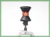


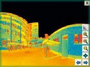

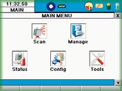


3 All-in-One Compatibility with standard surveying equipment Attach handles with Leica GPS SmartAntenna or prism holder, or use without handle for unobstructed overhead s Familiar, Total Station-like Interface Leica ScanStation C10 supports standard field workflows with a rich, familiar total station interface. Easy to learn touch screen operation. Smart X-Mirror design The mirror automatically spins for fast 360 and full dome and oscillates for efficient, targeted Integrated real-time streaming video with zoom Fast, accurate selection of scene and targets to be scanned Very-high speed, low noise pulsed laser Reduces field time while providing excellent range and survey-grade accuracy for each point Onboard controller and colour, graphic display Convenient control and on-site QA, including onboard review of Graphical icons make learning the instrument easy Leica firmware makes onboard management fast and efficient ent for instrument setup, operation and monitoring with rigorous field QA Integrated data storage Avoids the need for a laptop or separate handheld device; easy data transfer via USB or Ethernet interface Integrated, dual-axis level compensator For convenient survey-grade traversing and resection, plus tighter registration High-resolution digital image display Auto-adjusting, internal, high resolution digital camera for photo-realistic colour mapping of point clouds 3D viewing of target s Helps ensure Leica Geosystems- quality registration tion and geo- referencing Integrated battery Hot-swappable, standard total station battery Laser plummet and tribrach mount Standard procedures make ScanStation C10 easy to use


; forensic mapping;")


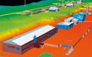

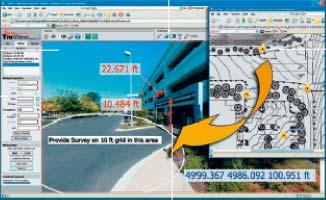

4 One Scanner for Any Application Leica Geosystems The All-in-One Supplier Delivers all of the benefits of High-Definition Surveying TM (HDS TM ) for more as-built, topographic and mapping surveys. Organizations that enter into laser scanning need more than just hardware. You also need software, training and support, and at some point you may even want more than one type of laser scanner. For meeting your complete needs in High-Definition Surveying, no organization measures up to Leica Geosystems the acknowledged industry leader. Benefits Lower cost Faster More accurate & complete Safer Less intrusive More informative Crash analysis Tunneling neling Software: Comprehensive, Powerful, Versatile Applications Design & engineering Construction & fabrication QA Asset management & archive Forensics & security planning Marketing proposals Research & education Fast, accurate quantities Engineering Facade Rail Leica Cyclone & Cyclone II This comprehensive, industry-standard suite includes powerful, stand alone modules for scanning, registration & geo-referencing, viewing, modeling & data management, and creating a wide range of deliverables & QA reports. Leica CloudWorx This popular suite of affordable CAD plug-ins makes it easy to learn and work efficiently with rich scan data directly in leading CAD applications for civil/survey, architectural, and plant projects. More Software Leica Geosystems also offers specialized scanning software solutions to meet the full range of user needs. These include free, web-based view/measure/markup software (Leica TruView); forensic mapping; mining; and efficient 3D meshing. Deformation Heritage detail Accurate clearances Efficient topos Worldclass Training and Support From on-site and factory-based classroom and field training to a global network of experienced HDS support specialists, no organization can help you succeed in High-Definition Surveying better than Leica Geosystems. Moreover, Leica Geosystems actively cultivates an HDS user community network that supports each other through idea exchange, training, backup hardware and backup staff. The user network includes a world - wide HDS user group conference and many local HDS user group meetings, where Leica staff and experienced users share their latest insights. Active Customer Care Working with the best maintained equipment and most up-to-date firmware and software ensures the best results for your business. That s what Leica Geosystems Customer Care Packages (CCP) offer. They protect your initial investment and keep your tools up-to-date for additional gains. Digital simulation Better retrofit Civil Construction


5 Whether you re designing a modification to a complex refinery piping system, surveying a site or documenting a historic building, you need reliable measurements. High-Definition Surveying scanning systems and software by Leica Geosystems provide you with exact data of what s there. When your as-built information has to be right, rely on Leica Geosystems. Leica Geosystems is best known for its pioneering scanning technology and trustworthy, total solutions: versatile, accurate laser scanners, industry standard point cloud software, and a full complement of accessories, training and support. Precision, quality and service from Leica Geosystems. When it has to be right. Illustrations, descriptions and technical data are not binding. All rights reserved. Printed in Switzerland Copyright Leica Geosystems AG, Heerbrugg, Switzerland, en VIII.09 RDV Total Quality Management our commitment to total customer satisfaction. Ask your local Leica Geosystems dealer for more information about our TQM program. Laser plummet: Laser class 2 in accordance with IEC resp. EN Leica ScanStation C10 Data sheet and specifications Leica HDS6100 Ultra-high speed Laser Scanner Leica HDS4400 Long range mine scanning system Leica Cyclone REGISTER Software information Leica Cyclone MODEL Software information Scanner: Laser class 3R in accordance with IEC resp. EN Leica Geosystems AG Heerbrugg, Switzerland
Leica ScanStation C5 Scalable Laser Scanner
 Leica ScanStation C5 Scalable Laser Scanner Leica ScanStation C5 Scalable from the Start Companies entering into laser scanning are often faced with inflexible and complex situations and would like a scalable
Leica ScanStation C10 Equipment List
 Leica ScanStation C10 Equipment List Table of Contents ScanStation C10 3 1 Scanner Set 3 Accessories for ScanStation C10 4 2 Accessory Set 4 3 Power Supply 4 3.1 Internal Power Supply 4 3.2 External Power
Leica High-Definition Surveying Systems. Leica HDS3000. The Industry Standard for High-Definition Surveying
 Leica High-Definition Surveying Systems Leica HDS3000 The Industry Standard for High-Definition Surveying HDS High-Definition Surveying TM : Laser Scanning Redefined High-Definition Surveying, or HDS,
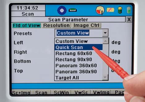
The Leica HDS Family. The Right Tool for the Job HDS3000 HDS2500 HDS4500. Cyclone & CloudWorx. Press the QuickScan button to define the field-of-view.
 HDS2500 High accuracy scanner, ideal for fixed or raised installations when leveled tripod mounting is not practical, or areas with less stringent field-of-view requirements. The Leica HDS Family Time-of-flight
Terrestrial 3D laser scanning Practical aspects
 Terrestrial 3D laser scanning Practical aspects ISPRS WG VI/5&SC Summer School 2007 by Gregor Bilban 3D laser scanning Benefits Lower data collection costs Reduction or elimination of re-visits More accurate
Leica Viva Imaging Enrich your Surveying Workflow
 Leica Viva Imaging Enrich your Surveying Workflow Your Vision: Images that Welcome to Leica Viva Imaging Enrich your Surveving Workflow Leica Viva Imaging enriches your surveying workflow with visual documentation
3D Laser Scanner VS1000 User Manual
 3D Laser Scanner VS1000 User Manual 1 VS1000 Introduction SMART MAX GEOSYSTEMS CO., LTD VS1000 3D Laser Scanner based on pulses ranging principle, could quick acquire massive point cloud data from the
Increase Field Survey Efficiency by Merging Technologies in NOVA MultiStation. Vincent Lui Leica Geosystems Ltd
 Increase Field Survey Efficiency by Merging Technologies in NOVA MultiStation Vincent Lui Leica Geosystems Ltd Advantages of Laser Scanning Advantages of TPS Measurements Advantages of Imaging Advantages
Leica System 1200 Software Integrated Software for GPS1200 and TPS1200
 Leica System 1200 Software Integrated Software for GPS1200 and TPS1200 Leica System 1200 Software System 1200 software includes SmartWorx the onboard TPS, GPS and RX1250 software and the Leica Geo Office
LEICA SPRINTER Electronic Level
 LEICA SPRINTER Electronic Level Error-free, Easy, Fast The New Standard for leveling at a breakthrough price With LEICA SPRINTER you become one of the world s fastest levelers Reliable Always reads the
Leica Public Safety Solutions Versatile. Durable. Admissible
 Leica Public Safety Solutions Versatile. Durable. Admissible Public Safety Solutions 3D Laser Scanners Software Training and Consulting Services Leica ScanStation PS Series Professional Grade 3D Laser
BIM & Digital Transformation Scotland Live 2018 Capturing 3D Reality at the push of a button
 BIM & Digital Transformation Scotland Live 2018 Capturing 3D Reality at the push of a button Gary Kelly Country Manager Scotland Leica Geosystems @LeicaScot Capturing 3D Reality at the push of a button
LEICA T1800 TC1800 TCA1800
 30 40 50 LEICA T1800 TC1800 TCA1800 Equal to any survey task Theodolites and total stations with 1 accuracy Survey instruments for every task Leica theodolites and total stations of the 1800 class Survey
Leica Cyclone 5.4 Technical Specifications
 Leica Cyclone 5.4 Technical Specifications HDS Scanner control and operation Scan Scan Scan Register Model Survey Viewer Acquire and display image Acquire image at specified resolution (high, medium, low)
3D IN GIS. 1. Presentation of the results of the scientific and technical contents
 G. Nagy, A. Szepes 3D in GIS 3D IN GIS NAGY Gábor, assistant professor, University of West Hungary, Faculty of Geoinformatics, Department of GIS, ng@geo.info.hu SZEPES András, associate professor, University
Leica Builder... Built to Build
 Leica Builder... Built to Build Leica Builder... Built to Build Instead of tediously setting up strings, with the Builder T100 my masons can start work right away. The Builder T100 or T200 can determine
Leica TPS700 Automated Series Increased surveying performance and comfort. PinPoint Technology
 Leica TPS700 Automated Series Increased surveying performance and comfort PinPoint Technology Leica TPS700 Automated Series with automation for more comfort Do you have to solve various surveying tasks
The world s most versatile pipe laser
 Provided by Xpert Survey Equipment Click Leica Piper 200 for Product Info and Updated Pricing Leica Piper 100/200 The world s most versatile pipe laser Leica Piper Solid performance in the pipe, over the
Leica Builder... Built to Build
 Leica Builder... Built to Build Leica Builder... Built to Build Instead of tediously setting up strings, with the Builder T100 my masons can start work right away. The Builder T100 or T200 can determine
Reality Capture using: RPAS Technologies & Image Laser Scanners
 Reality Capture using: RPAS Technologies & Image Laser Scanners by Johan Erasmus (RPAS Technologies) & Barend Bornman (Image Laser Scanners) from Aciel Geomatics Laser Scanners High-Definition Surveying
Leica Rugby 320 SG & 410/420 DG The toughest players on big fields. Construction Machine Control Agriculture
 Leica Rugby 320 SG & 410/420 DG The toughest players on big fields Construction Machine Control Agriculture Leica Rugby 320 SG & 410/420 DG When accuracy is the goal, Leica Rugby makes the grade Making
Leica FlexLine TS09plus Full Precision at High Performance
 Leica FlexLine TS09plus Full Precision at High Performance The First Plus: Original Leica Geosystems Quality For most, quality is relative. Not so at Leica Geosystems. To ensure our instruments meet the
Leica Geosystems Construction Products The right tools for any site
 Leica Geosystems Construction Products The right tools for any site - when it has to be right The right tools for any construction site Multipurpose and General Construction Lasers Multipurpose Leica Rugby
Leica TPS800 Series Powerful, efficient, reliable and intuitive. PinPoint Technology
 Leica TPS800 Series Powerful, efficient, reliable and intuitive PinPoint Technology powerful Leica TPS800 Performance Series... Three classes of accuracy TPS800 total stations are available in angular
Leica FlexLine TS06plus Top Precision meets High Efficiency
 Leica FlexLine TS06plus Top Precision meets High Efficiency The First Plus: Original Leica Geosystems Quality For most, quality is relative. Not so at Leica Geosystems. To ensure our instruments meet the
Protect by Leica Geosystems A Lifetime Guarantee
 Protect by Leica Geosystems A Lifetime Guarantee Protect by Leica Geosystems We always protect your success PROTECT by Leica Geosystems Lifetime Warranty No Cost Period Certified Quality Swiss Technology
LEICA TPS700 Performance Series
 LEICA TPS700 Performance Series TPS700 now with automatic for increased surveying performance and comfort LEICA TPS700 Performance Series... Do you have to solve various surveying tasks every day? Would
Leica NA700 Series Jobsite Tough, Clearly Precise
 Leica NA700 Series Jobsite Tough, Clearly Precise Leica NA700 The Most Robust Level. Jobsite Tough, Clearly Precise. A short drop onto the ground, a fall into water, vibrations from heavy machinery with
Leica DISTO S910 Measure point data and create plans
 Leica DISTO S910 Measure point data and create plans The world s first Measure anything from anywhere with P2P Technology It s been over 20 years since Leica Geosystems launched the first hand-held laser
Leica Cyclone 7.0 Leica CloudWorx 4.0 and 2.0 Technical Specifications
 Leica Cyclone 7.0 Leica CloudWorx 4.0 and 2.0 Technical Specifications Leica Cyclone 7.0 Technical Specifications HDS Scanner Control and Operation Acquire and display image Acquire image at specified
Geospatial Engineering Problems & Solutions Associated With NDP Roads, Tunnelling & Civil Engineering Projects Use of HDS Leica Laser Scanners
 Geospatial Engineering Problems & Solutions Associated With NDP Roads, Tunnelling & Civil Engineering Projects Use of HDS Leica Laser Scanners Laser Scanning Laser Scanning is a method of collecting large
The Trimble 3D Scanning Solution: Designed by Surveyors for Surveyors
 The Trimble 3D Scanning Solution: Designed by Surveyors for Surveyors TRIMBLE 3D SCANNING Designed by surveyors for surveyors, the Trimble 3D scanning solution follows the surveying workflow you re familiar
Trimble 3D Laser Scanning TRANSFORMING THE WAY THE WORLD WORKS
 Trimble 3D Laser Scanning Speed, Precision and Versatility Complete Solutions for Every Challenge CAPTURE AND DELIVER PRECISE DATA. FASTER. For scanning professionals, speed and precision are critical.
Leica Zeno 20 More than GPS
 Leica Zeno 20 More than GPS TECHNOLOGIES Leica Zeno 20 does so much more The Leica Zeno 20 is much more than just GPS it is a fusion of great technologies. Powerful and easy, it s the ultimate geospatial
High-End Surveying Precise, Fast and Intelligent. LEICA TPS1100 Professional Series
 High-End Surveying Precise, Fast and Intelligent LEICA TPS1100 Professional Series TPS1100 Professional Series More time for the essentials. Automated, practical programs are the main features of the TPS1100
Leica Rugby 320 SG & 410/420 DG The toughest players on big fields
 Leica Rugby 320 SG & 410/420 DG The toughest players on big fields Provided by Xpert Survey Equipment Click Leica Rugby 420DG for Product Info and Updated Pricing n Construction n Machine Control n Agriculture
Simplicity is the new black: The BLK360 story
 Simplicity is the new black: The BLK360 story Vanda KADLECIKOVA Leica Geosystems Heerbrugg, Switzerland E-mail: vanda.kadlecikova@leica-geosystems.com Abstract Meet the game changer. The new Leica BLK360
Leica Cyclone 8.1 Leica CloudWorx Technical Specifications
 Leica 8.1 Leica CloudWorx Technical Specifications Leica 8.1 Technical Specifications HDS SCANNER CONTROL AND OPERATION & REGISTRATION Acquire and display image ^ ^ ^ Acquire image at specified resolution
Version 2.0 English. Leica FlexLine TS02/TS06/TS09 Quick Guide
 Version 2.0 English Leica FlexLine TS02/TS06/TS09 Quick Guide To use the product in a permitted manner, please refer to the detailed safety instructions in the User Manual. Container Contents a b c d e
GeoMax Total Station Zoom30 Series
 GeoMax Total Station Zoom30 Series GeoMax About Us GeoMax is an internationally active company developing, manufacturing and distributing quality construction and surveying instruments. We provide a comprehensive
SPS ZOOM D Laser Scanner SPS ZOOM 300
 3D Laser Scanner 3D Laser Scanner A 3D laser scanner is a device that collects precise spatial data of objects or environments. The collected point cloud data can then be used to construct digital three
Leica Builder Series No boundaries anyone, anywhere, anytime
 Leica Builder Series No boundaries anone, anwhere, antime Multiple tasks one product. Still using a measuring tape or an optical theodolite? Do ou need a tool that fulfils all measuring tasks on our construction
Leica Cyclone 9.1 and Leica CloudWorx Technical Specifications
 Leica 9.1 and Leica CloudWorx Technical Specifications Leica 9.1 Technical Specifications REGISTRATION, VISUALIZATION, MODELING & QUERY TOOLS 3D navigation Panoramic view mode Cloud Level of Detail for
2/19/2018. Who are we? Who am I? What is Scanning? How does scanning work? How does scanning work? Scanning for Today s Surveyors
 2/19/2018 Who are we? Scanning for Today s Surveyors Survey, GIS, and Construction dealer Founded in 1988 Employee Owned Headquartered in Bismarck, ND States covered: ND, SD, MN, MT, WY, CO, UT, ID, WA,
Leica icon grade Intelligent grading solutions
 Leica icon grade Intelligent grading solutions intelligent CONstruction leica-geosystems.com Leica icon grade igd2 and igd3 Complete 2D and 3D solutions for all large earth moving projects igd2, icon grade
Leica PowerGrade Intelligent Grading Systems
 Leica PowerGrade Intelligent Grading Systems Leica PowerGrade Leica PowerGrade, the next-generation grade control systems from Leica Geosystems can revolutionise your construction process. It not only
3D-Laser Scanning and Surveying Collide. >> By H. Tate Jones, LS
 An architectural firm called on LandAir Surveying surveyors to scan downtown Cobb County in the area of a proposed courthouse, create a 3D model and then incorporate the new courthouse design into the
Geosystems Monday Hands-on Sessions
 Geosystems Monday Hands-on Sessions 1110: HDS University - Leica ScanStation P30/40 (and C10 & P20) Operation and Surveying Workflows (CEU eligible nominal fees will apply) The all new Leica ScanStation
A Sweet Success in Plant Documentation for Michigan Sugar Company
 A Sweet Success in Plant Documentation for Michigan Sugar Company COMPANY LOCATION 3D Imaging Services Flint, MI TOOLS USED Leica ScanStation P40 (solutionshardware-p40.html) Leica Cyclone Software (solutionssoftware-cyclone.html)
Leica ALS70. Airborne Laser Scanners Performance for diverse Applications
 Leica ALS70 Airborne Laser Scanners Performance for diverse Applications Three Models, One Result. Highest Productivity in all Applications. Imagine an affordable 500 khz pulse rate city-mapping LIDAR
Leica Geosystems Original Accessories The right selection
 Leica Geosystems Original Accessories The right selection Original Accessories Become the best surveyor with Leica Geosystems equipment Designed and built to the most stringent standards, Leica Geosystems
BEFORE YOU BUY: SEVEN CRITICAL QUESTIONS TO ASK ABOUT LASER SCANNERS. Robert Gardiner
 BEFORE YOU BUY: SEVEN CRITICAL QUESTIONS TO ASK ABOUT LASER SCANNERS Robert Gardiner Table of Contents Introduction... 3 Horizontal and Vertical Angular Accuracies... 4 Movement Tracking... 6 Range Limitations...
GeoMax Total Station Zoom30 Series
 GeoMax Total Station Zoom30 Series GeoMax About Us GeoMax is an internationally nology group with strong mar- The close cooperation within active company developing, ket positions within measure- the Hexagon
3D Industrial plants. Documentation
 3D Industrial plants Documentation Published by: FARO Europe GmbH & Co. KG, Lingwiesenstrasse 11/2, D-70825 Korntal-Münchingen, Tel: +49 7150 9797-0, Fax: +49 7150 9797-44, info@faroeurope.com, www.faro.com
FARO As-Built for AutoCAD Software Versatile Reality to CAD Solutions
 FARO As-Built for AutoCAD Software Versatile Reality to CAD Solutions FARO As-Built for Autodesk Revit Creating Efficiencies in Scan Data Extraction for BIM FARO As-Built for AutoCAD Software TM Versatile
POINT CLOUD based REVERSE ENGINEERING. Young-Ho Chai, Ph.D
 POINT CLOUD based REVERSE ENGINEERING Young-Ho Chai, Ph.D 3D Spatial Survey Workflow Hardware Requirements Phase Based Laser Scanner: -Leica ScanStation P20 x 1EA -Usage: Short-range, ~80m Time of Flight
Explore Laser Scanning in As-Built Survey. Vijay Chowdhary SE: BIM/CIM
 Explore Laser Scanning in As-Built Survey Vijay Chowdhary SE: BIM/CIM About FARO The world leader in portable 3-D measurement and imaging technology EMEA Headquarters Korntal-Münchingen, Germany APAC Headquarters
3D Laser Scanning Technology. Fast, Safe, Accurate. Rugged hardware and powerful software combined with streamlined survey workflow
 3D Laser Scanning Technology Fast, Safe, Accurate Rugged hardware and powerful software combined with streamlined survey workflow Maptek specialises in the research, development and application of 3D laser
Terrestrial LiDAR. Patrick Crawford. Harnessing the Power of Big Data for Asset and Facility Management WHITE PAPER SHAFER, KLINE & WARREN
 WHITE PAPER Terrestrial LiDAR Harnessing the Power of Big Data for Asset and Facility Management Patrick Crawford Team Leader, Geospatial Systems SHAFER, KLINE & WARREN Executive Summary Terrestrial LiDAR
Leica Viva GS14 Designed for Performance
 Leica Viva GS14 Designed for Performance Your Vision: Flexibility and Performance Introducing Leica Viva GS14 Your Tool for All GNSS Applications The Leica GS14 is the most compact and powerful GNSS receiver.
Leica Rugby 810, 820 & 840 The toughest construction lasers on site
 Leica Rugby 810, 820 & 840 The toughest construction lasers on site Leica Rugby The toughest construction lasers on site Leica Rugby construction lasers are more than just a product, they are an intelligent,
Leica FlexLine Equipment List
 Leica FlexLine Equipment List FlexLine Equipment List TS02 Instruments Total Stations for Prism Measurements 765268 TS02, 3"(1mgon) total station, laser plummet, 1 standard keyboard, user manual 765265
HP-L-8.9 LASER SCANNER
 PRODUCT BROCHURE HP-L-8.9 LASER SCANNER Cost-effective laser scanning for the ROMER Absolute Arm 2 HP-L-8.9 LASER SCANNER HIGHLIGHTS MAKING LASER SCANNING ACCESSIBLE TO ALL The HP-L-8.9 is an affordable
Leica FlexLine TS06plus Top precision meets high efficiency
 Leica FlexLine TS06plus Top precision meets high efficiency The First Plus: Original Leica Geosystems quality For most, quality is relative. Not so at Leica Geosystems. To ensure our instruments meet the
Laser Scanning. 3D Model is not existing and is required for: studies revamping maintenance HSE integration in another 3D model archiving
 Laser Scanning Laser Scanning Laser scanning is used whenever: 3D Model is not existing and is required for: studies revamping maintenance HSE integration in another 3D model archiving 2 Object acquisition
Leica Zeno GIS Equipment List
 Leica Zeno GIS Equipment List Table of Contents 1 Leica Zeno 10/Zeno 15 - GNSS/GIS Handhelds 3 2 GNSS Caps GS05 and GS06 for CS10 GIS & CS15 GIS 3 3 Packages 3 4 Additional Leica Zeno 10/Zeno 15 Options
Give your equipment some mojo!
 www.mojortk.com 0800 756 9665 Give your equipment some mojo! The new No Drift mojortk by Leica Geosystems revolutionises RTK technology for the agricultural industry. Why settle? Now you can have an RTK
Leica icon grade Intelligent grading systems NEW. igd4 SP System. i n telligent COnstruction
 Leica icon grade Intelligent grading systems NEW igd4 SP System i n telligent COnstruction Leica icon grade Maximize productivity, speed & flexibility The Leica icon grade solutions can revolutionize your
TMS Office and TMS Applications Dear TMS users,
 Amberg Technologies AG Trockenloostrasse 21 CH-8105 Regensdorf-Watt Switzerland Phone +41 44 870 92 22 Fax +41 44 870 06 18 info@amberg.ch www.amberg.ch/at Date: July 12 th, 2012 No: 07-2012 From: Product
Leica TPS1200+ Series High performance Total Station
 PointSolutions www.pointsolutions-us.com Leica TPS1200+ Series High performance Total Station Leica TPS1200+ Total Stations Packed with exciting new features, built for speed, accuracy, ease-of-use and
Leica Geosystems QuickStart Guide
 Leica Geosystems QuickStart Guide Product Leica Cyclone REGISTER 360 1.4.1 Date 3 January 2018 From HDS Software Product Management Contents Introduction... 2 Installation... 3 Licensing Setup... 4 Basic
Leica Rugby 810, 820 & 840 The toughest construction lasers on site
 Leica Rugby 810, 820 & 840 The toughest construction lasers on site Leica Rugby The toughest construction lasers on site Leica Rugby construction lasers are more than just a product, they are an intelligent,
Leica FlexField plus & Leica FlexOffice A Perfect Match
 Leica FlexField & Leica FlexOffice A Perfect Match FlexField Onboard Software General File Management Data Import Data Export Status icon bar Instrument Protection with PIN Stake Out beep Map Select Programs
 MS Series MS05A / MS1A Ultra-high Precision Auto-tracking Total Station n 0.5 / 1 Angular Accuracy n High-Performance, versatile EDM n 0.5 mm Distance Accuracy n Optimised Auto-Pointing n Laser Option
Leica Viva GS14 Designed for Performance
 Leica Viva GS14 Designed for Performance Your Vision: Flexibility and Performance Introducing Leica Viva GS14 Your Tool for All GNSS Applications The Leica Viva GS14 is the most compact and powerful GNSS
Leica TPS1200 Series High performance Total Station
 Leica TPS1200 Series High performance Total Station Leica TPS1200 Total Stations Packed with exciting new features, built for speed, accuracy, ease-of-use and reliability. Leica TPS1200 Total Stations
Leica TS11 Quick Guide. Version 2.0 English
 Leica TS11 Quick Guide Version 2.0 English TS11, Important Information about your Instrument 1 Important Information about your Instrument 2 Read and follow the User Manual on the accompanying DVD before
Version 5.0 English. Leica ScanStation C10/C5 User Manual
 Version 5.0 English Leica ScanStation C10/C5 User Manual ScanStation C10/C5, Introduction Introduction 2 Purchase Congratulations on the purchase of a ScanStation C10/C5 instrument. This manual contains
Leica Absolute Tracker AT401 Absolutely portable
 www.leica-geosystems.com/metrology Leica Absolute Tracker AT401 Absolutely portable Leica Absolute Tracker Absolutely portable» The Leica Absolute Tracker AT401 is a portable coordinate measuring machine
UAVs & IMAGES ACCESSORIES ABOUT GEXCEL
 LIDAR SOFTWARE UAVs & IMAGES MONITORING MOBILE MAPPING ACCESSORIES OTHER ABOUT GEXCEL BUSINESS TEAM LOCATIONS Gexcel offices are located in Italy in two Innovation Centers SALES NETWORK Gexcel s worldwide
Leica TPS1200 Series High performance Total Station
 Leica TPS1200 Series High performance Total Station Leica TPS1200 Total Stations Packed with exciting new features, built for speed, accuracy, ease-of-use and reliability. Leica TPS1200 Total Stations
Trimble Realworks Software
 TECHNICAL NOTES Trimble Realworks Software A Powerful 3D Laser Scanning Office Software Suite DESIGNED FOR TODAY S MULTIFACETED SCANNING PROFESSIONAL, TRIMBLE REALWORKS IS A POWERFUL OFFICE SOFTWARE THAT
Leica Geosystems Original Accessories The right selection
 Leica Geosystems Original Accessories The right selection Original Accessories Become the best surveyor with Leica Geosystems equipment Designed and built to the most stringent standards, Leica Geosystems
Leica Scan Station P20 User Manual
 Leica Scan Station P20 User Manual If searching for a ebook Leica scan station p20 user manual in pdf form, then you have come on to the right website. We present the complete edition of this book in PDF,
POLARIS Laser Scanner
 POLARIS Laser Scanner Compact, Powerful, Scanning Technology from Teledyne Optech The Optech Polaris Terrestrial Laser Scanner (TLS) delivers accurate, precise data faster than ever before, bridging the
3D Laser Scanner. Fast, Portable, Accurate. Long range laser scanner Modular design configured to suit your survey needs
 3D Laser Scanner Fast, Portable, Accurate Long range laser scanner Modular design configured to suit your survey needs Introducing the Maptek I-Site 8820 laser scanner The Maptek I-Site 8820 laser scanner
3D Laser Scanning Technology. Rugged hardware and powerful software combined with streamlined survey workflow
 3D Laser Scanning Technology Rugged hardware and powerful software combined with streamlined survey workflow I-Site XR3 laser scanner The Maptek I-Site XR3 laser scanner represents the latest laser imaging
HANDHELD MOBILE MAPPING / 3D LASER MAPPING SOLUTIONS. ZEB Family Brochure. geoslam.com
 HANDHELD MOBILE MAPPING / 3D LASER MAPPING SOLUTIONS ZEB Family Brochure geoslam.com NEW Long range, greater intensity, UAV ready HANDHELD BACKPACK UAV Effortless Data Capture Your tool to capture, view
Leica No Date From To. software for. We are pleased to. point cloud. system. Grid and intelligen. Orientati. Then you. view.
 No Date From To 27-2013 BU Terrestrial Laser Scanning 29 th October 2013 Bill Wallace All representatives Leica CloudWorx for AutoCAD 5.0 Product Release Announcement We are pleased to announce the release
Trimble Total Stations
 Trimble s The Most Advanced Stations. The Ultimate in Efficiency. Trimble C3 Mechanical Trimble C5 Mechanical Trimble S5 Trimble S7 Trimble S9 Trimble SX10 Trimble s: trusted today, designed for tomorrow.
Most as-built information is still manually collected. Today s Design Market
 Agenda 1. Overview of 3D laser scanning 2. HDS 3D Laser scanning applications Leica ScanStation2 True Color Scan 3. Demonstration of HDS & Trueview 4. Questions and Answers The advanced 3D Laser Scanning
ROAD-SCANNER COMPACT APPLICATION FIELDS MAIN FEATURES
 ROAD-SCANNER COMPACT Mobile Mapping System by GEXCEL & SITECO collaboration A smaller mobile system for asset management and cartography suited for ZOLLER & FRÖHLICH PROFILER 9012 laser scanner. 2 + 3
Version 1.0 English. Leica TS15 Quick Guide
 Version 1.0 English Leica TS15 Quick Guide TS15, Important Information about your Instrument 1 Important Information about your Instrument 2 Read and follow the User Manual on the accompanying DVD before
Trimble Total Stations
 Trimble Total Stations The Most Advanced Stations. The Ultimate in Efficiency. FASTER, EASIER AND MORE PRODUCTIVITY Our seven total stations, C3, C5, S5, S7, S9, S9 HP and the SX10; deliver even greater
Provided by Xpert Survey Equipment Click Leica TS06 for Product Info and Updated Pricing. Leica FlexLine TS06plus Top precision meets high efficiency
 Provided by Xpert Survey Equipment Click Leica TS06 for Product Info and Updated Pricing Leica TS06plus Top precision meets high efficiency The First Plus: Leica Geosystems quality For most, quality is
in accordance with ISO Leica DISTO D410/D510 The original laser distance meter
 We keep our promises in accordance with ISO 16331-1 Leica DISTO D410/D510 The original laser distance meter Accuracy & range Colour display and digital Pointfinder with 4x zoom Precise targeting and measuring
Leica Nova MS60 White paper
 Leica Nova MS60 White paper August 2017 Hannes Maar, Hans-Martin Zogg Leica Geosystems AG Heerbrugg, Switzerland leica-geosystems.com Leica Nova MS60 The new experience in measuring technology site which
Leica Captivate. Software Release Notes. Field Controllers: CS20, CS35 Total Stations: TS16, TS60, MS60, TS13 GNSS Sensors: GS18 T
 Leica Captivate v4.10 Software Release Notes Product Leica Captivate Field Controllers: CS20, CS35 Total Stations: TS16, TS60, MS60, TS13 GNSS Sensors: GS18 T Release date 10 th December 2018 Maintenance
Shaping the World with Leica Zeno GIS Asset Collection & Management
 Shaping the World with Leica Zeno GIS Asset Collection & Management Edward Toh GIS Segment Manager, APAC Agenda Power of Geography Location bring values Case Studies Integration of Surveyors into GIS Leica
technical notes trimble realworks software
 technical notes trimble realworks software A POWERFUL 3D LASER SCANNING OFFICE SOFTWARE SUITE Designed for today s multifaceted scanning professional, Trimble RealWorks is a powerful office software that