G2-AS100. Presents: A mid-format fully integrated photogrammetric camera
|
|
|
- Louise Kelley
- 6 years ago
- Views:
Transcription


1 Presents: G2-AS100 A mid-format fully integrated photogrammetric camera Designed and manufactured by Global Geo Supplies, Inc. Lone Tree, Colorado USA 1
2 TABLE OF CONTENTS CAMERA SPECIFICATIONS LENSES PERFORMANCE WITH 50mm LENS PERFORMANCE WITH 70mm LENS SYSTEM COMPONENTS AND SOFTWARE STACK GNSS + INS SPECIFICATIONS GYMBAL SPECIFICATIONS SENSOR INTEGRATION 2

3 SYSTEM COMPONENTS Phase One ixu-rs MP RGB camera Resolution: 100 MP/ x 8708 Dynamic range: >84 db Aspect ratio: 4:3 Pixel size: 4.6 micron CCD size effective: 53.4 x 40 mm Lens factor: 1.0 Light sensitivity (ISO): Lens mount: Phase One RS dedicated Shutter speed: up to 1/2500 second Shutter life: Up to 500,000 cycles Shutter control: 1/3 f-stop increments Interfaces USB 3.0 Secured power input (LEMO) Camera trigger Mid-exposure pulse Live View/HDMI 1920 x p/30p 1280 x p/60p GPS/IMU support Applanix, NovAtel, IGI, NMEA Devices Data storage 1 TB SSD storage (in ix Controller) CompactFlash card Type I/II including UDMA 6 and 7 Capture rate at full resolution: 0.85 sec RAW File compression IIQ large: 100 MB IIQ small: 65 MB Camera status 3


4 New He line of Rodenstock lenses With high reliability shutter Rodenstock 32 mm f/4.0 Rodenstock 40 mm f/4.0 Specially designed for aerial photography Shutter lifetime of 500,000 cycles Exposure time down to 1/2500 of a second Camera cycle of up to 0.6 Seconds frame to frame New Phase One RS secure lens mount Rodenstock 50 mm f/4.0 Rodenstock 70 mm f/5.6 4
![GSD, SWATH AND AREA COVERAGE WITH 50mm LENS FOCAL LENGTH = 50mm AGL [ft] GSD [cm] Swath [m] Length [m] Area [km 2 ] 1,000 2.](/docs-images/73/68635340/images/5-1.jpg "8 326 244 0.1 2,500 7.0 814 610 0.5 5,000 14.0 1628 1221 2.0 6,000 16.8 1953 1465 2.9 12,000 33.6 3906 2930 11.")
5 GSD, SWATH AND AREA COVERAGE WITH 50mm LENS FOCAL LENGTH = 50mm AGL [ft] GSD [cm] Swath [m] Length [m] Area [km 2 ] 1, , , , , Length Swath 5
6 GSD, SWATH AND AREA COVERAGE WITH 70mm LENS FOCAL LENGTH = 70mm AGL [ft] GSD [cm] Swath [m] Length [m] Area [km 2 ] 1, , , , , Length Swath 6
7 Enlargement SAMPLE IMAGES 7

8 Enlargement SAMPLE IMAGES 8


9 SYSTEM COMPONENTS AND SOFTWARE STACK Mission Planning and execution Phase One ixu-rs MP Camera Gyro-Stabilized Gimbal Camera control Image georeferencing XU Camera controller GNSS + INS Georeferencing Unit Software packages for Deliverable products 9
 with optional RAID system for data recording IX CAMERA CONTROLLER Unlimited storage with multiple SSD drives (max. capacity per SSD pair 28,500 images) 10")
10 SYSTEM COMPONENTS FEATURES 4th Generation Intel Core i7 Fanless cooling Rugged construction 8 GB of RAM Power and drive multiple cameras Pre-installed with ix Capture and Capture One DB Two removable solid state drives (SSD) with optional RAID system for data recording IX CAMERA CONTROLLER Unlimited storage with multiple SSD drives (max. capacity per SSD pair 28,500 images) 10
11 SYSTEM COMPONENTS GNSS + INS GEOREFERENCING UNIT Features Meter to centimeter level accuracy Regulated VDC input 125 Hz navigation solution and raw measurement output Serial, USB, CAN and Multi I/O interface including dedicated wheel sensor input GPS, GLONASS, SBAS and RTK support Benefits SPAN enabled enclosure featuring NovAtel's tightly coupled OEM615 GNSS + INS engine Tactical grade IMU performance Commercially exportable IMU Small, lightweight and rugged Ideal for airborne, ground and marine applications 11
12 SYSTEM COMPONENTS CSM130 GIMBAL Angular Stabilization Ranges Arbitary Horizontal Axes: ±15.0 degree Pitch - at 0 degree Roll: ±15.0 degree Roll - at 0 degree Pitch: ±15.0 degree Yaw (Drift): ±25.0 degree Deviation from Perpendicular (Angular Rate of the base plate ±10.0 degree/second) with IMU support (accuracy depends on IMU) 0.2 degree rms Payload: kg, lb. Operational Voltage 28 VDC ( VDC) Power Consumption at 28 VDC 30 W rms / Peak 90 W Operating Temperature -25 C C -13 F F Storage Temperature -50 C C -58 F F Useable Diameter: 130 mm, 5.1 in Mass: 5.2 kg, 11.5 lb. Dimensions CSM 130 (horizontal position) Length: 290 mm / 11.4 in Width: 275 mm / 10.8 in Height: 120 mm / 4.7 in 12
")

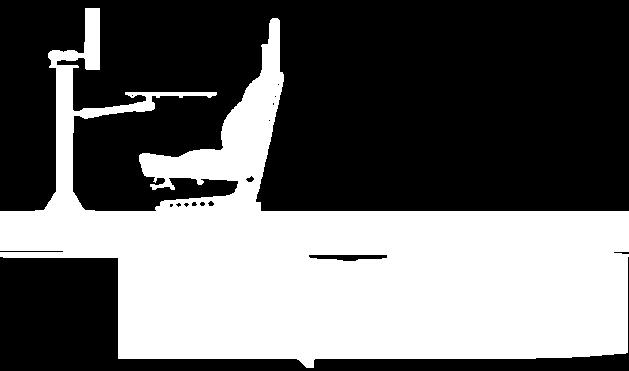
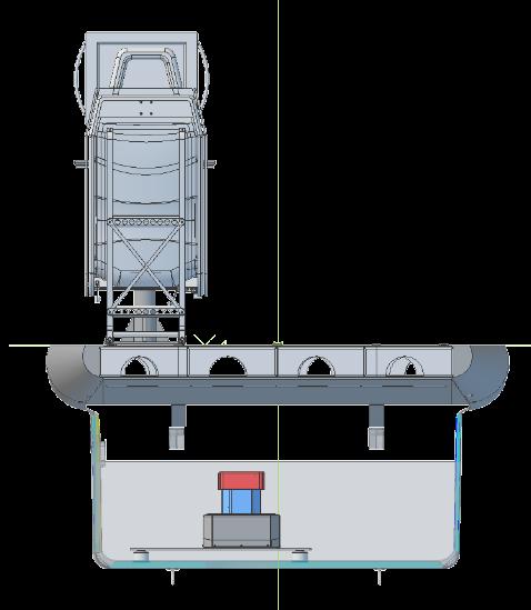
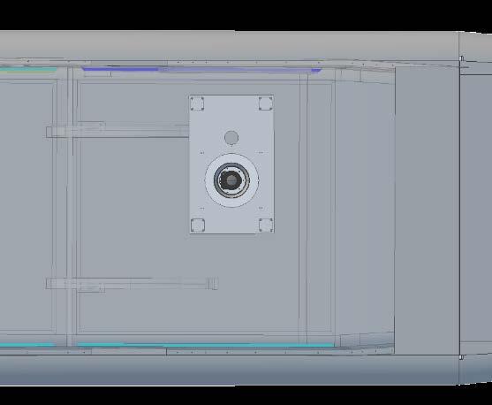
13 SENSOR INTEGRATION All cargo pod components are integrated into a single subsystem containing: 1) Gyro-stabilized gimbal 2) Camera 3) GNSS+IMU sensors 4) Mounting base with vibration dampers custom made for each installation (not shown here) 13


14 GNSS Antenna Pilot / Operator Terminals Camera controller 28V Aux AIRCRAFT ELECTRICAL INTEGRATION Sensor assembly (Installable in cabin or Cargo Pod) 14


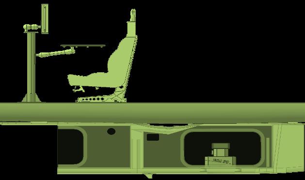

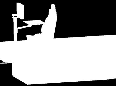
15 Cessna Caravan 208B Cargo POD Installation 15


16 G2-AS100 Fitting in AVCON 20 ft 3 King Air POD
17 Contact information: Guillermo M. Gallo, VP Business Development Tel: , Cel: G2 Airborne Systems is a trademark of Global Geo Supplies, Inc. 17
Phase One ixa-r Camera. Fully Integrated Aerial Photography Solutions
 Phase One ixa-r Camera Fully Integrated Aerial Photography Solutions Phase One ixa-r Camera System The Phase One ixa-r aerial camera system is an integrated medium format camera system that was designed
ixu-rs1900 Aerial Solutions
 Aerial Solutions Seeing the Large Picture Medium Format Evolves Aerial Camera Phase One 190MP Aerial Camera series is the latest Phase One innovation to offer large format metric camera functionality.
P h a s e O n e i X U - RS A c c u r a c y A n a l y s i s. T h e f o r e f r o n t o f a e r i a l p h o t o g r a p h y
 P h a s e O n e i X U - RS1 0 0 0 A c c u r a c y A n a l y s i s T h e f o r e f r o n t o f a e r i a l p h o t o g r a p h y 1 Phase One Industrial Aerial Survey Products ixu-rs1000, ixu1000 series
Phase One ixu 150 The world s smallest and lightest integrated digital medium format aerial camera
 Phase One ixu 150 The world s smallest and lightest integrated digital medium format aerial camera Phase One ixu 150 Camera System The Phase One ixu 150 camera is the smallest and lightest integrated digital
SPAN. novatel.com. Tightly coupled GNSS+INS technology performance for exceptional 3D, continuous position, velocity & attitude
 SPAN novatel.com Tightly coupled GNSSINS technology performance for exceptional 3D, continuous position, velocity & attitude For comprehensive SPAN information, visit: www.novatel.com/span SPAN Technology
Accuracy Assessment of POS AVX 210 integrated with the Phase One ixu150
 White Paper 3/17/2016 Accuracy Assessment of POS AVX 210 integrated with the Phase One ixu150 Omer Mian, Joe Hutton, Greg Lipa, James Lutes, Damir Gumerov, Srdjan Sobol Applanix, William Chan - GeoPixel
Iwane Mobile Mapping System
 Iwane Mobile Mapping System Geo-Imaging Mobile Mapping Solution Iwane Mobile Mapping System (IMMS) is high-efficient, easyto-use, end-to-end solution that provides tremendous flexibility in collecting,
Leica Systems Overview
 RC30 AERIAL CAMERA SYSTEM Leica Systems Overview The Leica RC30 aerial film camera is the culmination of decades of development, started with Wild's first aerial camera in the 1920s. Beautifully engineered
Leica ADS80 and Leica XPro - A total solution for photogrammetric mapping
 Leica ADS80 and Leica XPro - A total solution for photogrammetric mapping Ruedi Wagner, VP Imaging, Geospatial Solutions Division Phowo 2009 - Real Geospatial Solutions What else can I do with my sensor?
UAV Hyperspectral system for remote sensing application
 UAV Hyperspectral system for remote sensing application The system consists airborne imaging spectrophotometer placed on a frame suitable for use aircraft, a UAV helicopter and all components needed for
P H A S E O N E I N D U S T R I A L. T h e w o r l d l e a d e r i n h i g h r e s o l u t i o n i m a g i n g
 P H A S E O N E I N D U S T R I A L T h e w o r l d l e a d e r i n h i g h r e s o l u t i o n i m a g i n g 1 WE ARE A WORLD LEADING PROVIDER of medium format digital imaging systems and solutions for
Inertial Systems. Ekinox Series TACTICAL GRADE MEMS. Motion Sensing & Navigation IMU AHRS MRU INS VG
 Ekinox Series TACTICAL GRADE MEMS Inertial Systems IMU AHRS MRU INS VG ITAR Free 0.05 RMS Motion Sensing & Navigation AEROSPACE GROUND MARINE Ekinox Series R&D specialists usually compromise between high
InteLAS Family of Mobile LiDAR Systems
 InteLAS Family of Mobile LiDAR Systems September 2015 What we do ilinks Geosolutions LLC Hydrographic surveying and seabed modeling Topographic surveying and mobile mapping Systems engineering and integration
Project: UAV Payload Retract Mechanism. Company Background. Introduction
 Ascent Vision Technologies LLC 90 Aviation Lane Belgrade, MT 59714 Tel 406.388.2092 Fax 406.388.8133 www.ascentvision.com Project: UAV Payload Retract Mechanism Company Background Ascent Vision Technologies
Product Guide UPDATED. Look into NovAtel s Precise Positioning Engines and Enclosures
 Look into NovAtel s Precise Positioning Engines and Enclosures See why NovAtel s extensive product line, including L1 and L1/L2 positioning UPDATED engines and enclosures, is on the leading edge of positioning
MIDAS 5 Camera System. (Multi-camera Integrated Digital Acquisition System)
") MIDAS 5 Camera System (Multi-camera Integrated Digital Acquisition System) MIDAS 5 in Puppet Air STP-400 Mount The MIDAS Solution The MIDAS 5 system is a complete turn-key oblique Imaging solution for
MIDAS 5 Camera System (Multi-camera Integrated Digital Acquisition System) MIDAS 5 in Puppet Air STP-400 Mount The MIDAS Solution The MIDAS 5 system is a complete turn-key oblique Imaging solution for
NEW RIEGL. Triple Scanner Mobile Mapping System Specifically Designed for Rail Application. Typical Applications
 NEW RIEGL VMX -RAIL 3 MHz pulse repetition rate, and 750 lines per second resulting in up to 7000 pts/m 2 in 3m range at 80 km/h platform speed 420m 3 MHz optional The is a fully integrated Mobile Laser
Datasheet. A5D Aerial. Main Features. Medium Format digital capture advantage
 A5D Aerial With its image sensor specially selected to provide the flatness required for applications such as advanced mapping, the new A5D is the ideal camera for aerial photography. The A5D also features
Phase One ixr Camera System Fully Integrated Reproduction Photography Solutions
 Phase One ixr Camera System Fully Integrated Reproduction Photography Solutions Image on cover (right): Nicolas Dubois - Art Digital Studio 2 Phase One ixr The Phase One ixr is a fully integrated, robust
SimActive and PhaseOne Workflow case study. By François Riendeau and Dr. Yuri Raizman Revision 1.0
 SimActive and PhaseOne Workflow case study By François Riendeau and Dr. Yuri Raizman Revision 1.0 Contents 1. Introduction... 2 1.1. Simactive... 2 1.2. PhaseOne Industrial... 2 2. Testing Procedure...
2-in-1 Large Format and Oblique Aerial Camera Systems for 3D Urban Mapping. Philipp Grimm EUROSDR/ISPRS Workshop Oblique, Barcelona,
 2-in-1 Large Format and Oblique Aerial Camera Systems for 3D Urban Mapping Philipp Grimm EUROSDR/ISPRS Workshop Oblique, Barcelona, 09.10.2017 Mission Planning & Flight Guidance Sensor Management GNSS/IMU
Leica PAV30. Gyro-Stabilized Camera Mount
 Leica PAV0 Gyro-Stabilized Camera Mount Leica PAV0 High Quality Aerial Photography The Leica PAV0 gyro-stabilized mount has been developed by Leica Geosystems aerial camera engineers for compensation of
Phase One ixa Camera System Fully Integrated Aerial Photography Solutions
 Phase One ixa Camera System Fully Integrated Aerial Photography Solutions Phase One ixa Camera System The Phase One ixa aerial camera system is an integrated medium format camera system that was designed
Leica ALS70. Airborne Laser Scanners Performance for diverse Applications
 Leica ALS70 Airborne Laser Scanners Performance for diverse Applications Three Models, One Result. Highest Productivity in all Applications. Imagine an affordable 500 khz pulse rate city-mapping LIDAR
Leica ALS80 Airborne Laser Scanners Performance for every Application
 Leica ALS80 Airborne Laser Scanners Performance for every Application Three Models, One Result. Highest Productivity in all Applications. Imagine an affordable city-mapping LIDAR system with an industry-leading
Trimble GeoSpatial Products
 Expanding Solutions for Photogrammetric and Remote Sensing Professionals 55 th Photogrammetric Week in Stuttgart September 7 th 2015 Tobias Heuchel, Trimble Stuttgart, Germany Trimble GeoSpatial Products
Leica Geosystems UAS Airborne Sensors. MAPPS Summer Conference July 2014 Alistair Stuart
 Leica Geosystems UAS Airborne Sensors MAPPS Summer Conference July 2014 Alistair Stuart 1 Sensors for UAS! Promise of UAS is to expand aerial data acquisition capabilities for traditional and non-traditional
P/N: FLIR Aerial Commercial Building Inspector Kit (30 Hz) Other output formats Social media
 Other output formats Social media") Page 1 of 7 Other output formats Social media Click here to refresh the page Rev. 35005 Last modified 2016-04-15 Additional supporting documents: Mechanical drawings P/N: 75604-0404 FLIR Aerial Commercial
Page 1 of 7 Other output formats Social media Click here to refresh the page Rev. 35005 Last modified 2016-04-15 Additional supporting documents: Mechanical drawings P/N: 75604-0404 FLIR Aerial Commercial
LiDAR & Orthophoto Data Report
 LiDAR & Orthophoto Data Report Tofino Flood Plain Mapping Data collected and prepared for: District of Tofino, BC 121 3 rd Street Tofino, BC V0R 2Z0 Eagle Mapping Ltd. #201 2071 Kingsway Ave Port Coquitlam,
7.58 lbs (3440 g, including two batteries, without gimbal and camera)
") Appendix Specifications Aircraft Weight Max Takeoff Weight GPS Hovering Accuracy Max Angular Velocity Max Tilt Angle Max Ascent Speed Max Descent Speed Max Takeoff Sea Level Max Wind Speed Resistance T650
Appendix Specifications Aircraft Weight Max Takeoff Weight GPS Hovering Accuracy Max Angular Velocity Max Tilt Angle Max Ascent Speed Max Descent Speed Max Takeoff Sea Level Max Wind Speed Resistance T650
Product Description. Leica RC30 Aerial Camera System. Overview
 Leica RC30 Aerial Camera System Overview The Leica RC30 is an aerial film camera system of top quality and performance, capable of acquiring the very best aerial photographs with black and white, color
UHD 185 FAQs. Optical System
 UHD 185 FAQs System Setup How is a typical setup of the UHD 185? Is a wireless control during flight possible? How do I trigger the image acquisition? What is the power consumption? What are the specs
APPLANIX DIRECT GEOREFERENCING FOR AIRBORNE MAPPING. and FLIGHT MANAGEMENT SYSTEMS. The Better Way to Reduce the Cost of Airborne Mapping
 APPLANIX DIRECT GEOREFERENCING and FLIGHT MANAGEMENT SYSTEMS FOR AIRBORNE MAPPING The Better Way to Reduce the Cost of Airborne Mapping capture everything. precisely. Applanix Direct Georeferencing and
Qinertia THE NEXT GENERATION INS/GNSS POST-PROCESSING SOFTWARE. For all mobile surveying applications
 Qinertia THE NEXT GENERATION /GNSS POST-PROCESSING SOFTWARE For all mobile surveying applications Survey Efficiently, Survey Anywhere, Survey Serenely. QINERTIA has been designed to help surveyors get
Installation of DynaFlight-III System
 DynaNav Systems Inc. 730 11731 Baynes Road Pitt Meadows. BC, Canada, V3Y 2B3 www.dynanav.com THIS MANUAL CONTAINS HELPFUL HINTS ON: Installation of DynaFlight-III System DynaFlight Airborne Aerial Application
Phase One Industrial Fully Integrated Drone Solution
 Phase One Industrial Fully Integrated Drone Solution Fully Integrated Drone Solution The use of drones and UAV-based platforms in the aerial imaging market is increasing rapidly, and remote sensing is
Overview of the Trimble TX5 Laser Scanner
 Overview of the Trimble TX5 Laser Scanner Trimble TX5 Revolutionary and versatile scanning solution Compact / Lightweight Efficient Economical Ease of Use Small and Compact Smallest and most compact 3D
ZLS Corporation. ZLS Dynamic Meter for Marine Applications EXCELLENCE IN GRAVITY METERS. ZLS Dynamic Meter. Applications
 ZLS Corporation EXCELLENCE IN GRAVITY METERS Highest Quality Most Precise Most Rugged Most Reliable Applications Eliminates damper adjustments Eliminates cross-coupling errors Smaller residual imperfection
VMX -2HA RIEGL. High Speed, High Performance Dual Scanner Mobile Mapping System. Typical Applications
 RIEGL 420m 2 MHz VMX -2HA optional High-Speed 10 GigE Link for acquisition of 2 million measurements/sec and image data of up to 9 different high-end cameras The is a High Speed, High Performance Dual
Leica - Airborne Digital Sensors (ADS80, ALS60) Update / News in the context of Remote Sensing applications
 Update / News in the context of Remote Sensing applications") Luzern, Switzerland, acquired with GSD=5 cm, 2008. Leica - Airborne Digital Sensors (ADS80, ALS60) Update / News in the context of Remote Sensing applications Arthur Rohrbach, Sensor Sales Dir Europe,
Luzern, Switzerland, acquired with GSD=5 cm, 2008. Leica - Airborne Digital Sensors (ADS80, ALS60) Update / News in the context of Remote Sensing applications Arthur Rohrbach, Sensor Sales Dir Europe,
Specifications. Inspire 2. Aircraft (Model: T650) 7.25 lbs (3290 g, including two batteries, without gimbal and camera)
 7.25 lbs (3290 g, including two batteries, without gimbal and camera)") Specifications Inspire 2 Aircraft (Model: T650) Diagonal Distance(propeller excluded) Max Takeoff 8.82 lbs (4000 g) 7.25 lbs (3290 g, including two batteries, without gimbal and camera) 18 inch (605 mm,
Specifications Inspire 2 Aircraft (Model: T650) Diagonal Distance(propeller excluded) Max Takeoff 8.82 lbs (4000 g) 7.25 lbs (3290 g, including two batteries, without gimbal and camera) 18 inch (605 mm,
Phase One Industrial Fully Integrated Drone Solution
 Phase One Industrial Fully Integrated Drone Solution Fully Integrated Drone Solution The use of drones and UAV-based platforms in the aerial imaging market is increasing rapidly, and remote sensing is
Specifications Summary 1. Array Size (pixels) Pixel Size. Sensor Size. Dark Current 2. Pixel Well Depth (typical) e e -
 Pixel Size. Sensor Size. Dark Current 2. Pixel Well Depth (typical) e e -") AVAILABLE WITH LOW NOISE & HIGH DYNAMIC RANGE sensor options Apogee Alta Series System Features 1 High Resolution Sensors 1.0 Megapixel sensor with large 24 mm pixels deliver a large field of view with
AVAILABLE WITH LOW NOISE & HIGH DYNAMIC RANGE sensor options Apogee Alta Series System Features 1 High Resolution Sensors 1.0 Megapixel sensor with large 24 mm pixels deliver a large field of view with
Technical Specifications for High speed PIV and High speed PIV-PLIF system
 Technical Specifications for High speed PIV and High speed PIV-PLIF system MODULE A. HIGH SPEED PIV (3-C) A1. Double Cavity High Speed Laser (up to 10 khz): The vendor should provide Dual Head (DH) laser
A1 0 p o r A itra- b S le e A AS b y ss o t l e u m t i ei g r r A A v v ii t t y y m m e e t t e e r
 A10 portable A i r - S e a Sabsolute y s t e m I I gravity meter the latest generation of dynamic gravity meters In 1965 LaCoste & Romberg introduced the world s first dynamically stabilized platform gravity
REMOTE SENSING LiDAR & PHOTOGRAMMETRY 19 May 2017
 REMOTE SENSING LiDAR & PHOTOGRAMMETRY 19 May 2017 SERVICES Visual Inspections Digital Terrain Models Aerial Imagery Volume Computations Thermal Inspections Photo maps Aerial Video Training & Consultancy
Phase One ixa-r-180 Aerial Triangulation
 Phase One ixa-r-180 Aerial Triangulation Accuracy Assessment Results Revision 1 Oodi Menaker and Stephen Epstein Table of Contents 1. Introduction... 1 2. Method... 1 2.1. Selection of Test Area... 2 2.2.
APN-080: SPAN Data Collection Recommendations
 APN-080: SPAN Data Collection Recommendations APN-080 0A January 2018 Table of Contents Chapter 1 Overview 1.1 IMU Type 3 Chapter 2 INS Alignment 2.1 INS Alignment Environment 4 2.2 INS Alignment Quality
LANDINS Georeferencing and Orientation System
 LANDINS Georeferencing and Orientation System LANDINS Georeferencing and Orientation System Landins is a simple, turnkey position and orientation system for land-based mobile applications. It offers dependable
Specifications Summary 1. Array Size (pixels) Pixel Well Depth (typical) 94,000 e - Dark Current 2. Read Noise 3
 Pixel Well Depth (typical) 94,000 e - Dark Current 2. Read Noise 3") Apogee Alta Series System Features 1 High Resolution Sensor 9.3 Megapixel sensor with 12 mm pixels delivers an exceptionally large field of view with high resolution. Programmable TE cooling down to 45
Apogee Alta Series System Features 1 High Resolution Sensor 9.3 Megapixel sensor with 12 mm pixels delivers an exceptionally large field of view with high resolution. Programmable TE cooling down to 45
novatel.com For comprehensive Waypoint information, visit:
 novatel.com For comprehensive Waypoint information, visit: www.novatel.com/waypoint novatel.com Waypoint EXCEPTIONAL POST-PROCESSING SOFTWARE Enhance your GNSS Position, Velocity and Attitude Accuracy
PHANTOM 4 PRO SPECS AIRCRAFT VISION SYSTEM. HomeProductsPhantom 4 ProSpecs. Weight (Battery & Propellers Included) 1388 g
 1388 g") PHANTOM 4 PRO SPECS HomeProductsPhantom 4 ProSpecs AIRCRAFT Weight (Battery & Propellers Included) Diagonal Size (Propellers Excluded) Max Ascent Speed Max Descent Speed Max Speed 1388 g 350 mm S-mode:
PHANTOM 4 PRO SPECS HomeProductsPhantom 4 ProSpecs AIRCRAFT Weight (Battery & Propellers Included) Diagonal Size (Propellers Excluded) Max Ascent Speed Max Descent Speed Max Speed 1388 g 350 mm S-mode:
GPS-Aided Inertial Navigation Systems (INS) for Remote Sensing
 for Remote Sensing") GPS-Aided Inertial Navigation Systems (INS) for Remote Sensing www.inertiallabs.com 1 EVOLUTION OF REMOTE SENSING The latest progress in Remote sensing emerged more than 150 years ago, as balloonists took
GPS-Aided Inertial Navigation Systems (INS) for Remote Sensing www.inertiallabs.com 1 EVOLUTION OF REMOTE SENSING The latest progress in Remote sensing emerged more than 150 years ago, as balloonists took
Exterior Orientation Parameters
 Exterior Orientation Parameters PERS 12/2001 pp 1321-1332 Karsten Jacobsen, Institute for Photogrammetry and GeoInformation, University of Hannover, Germany The georeference of any photogrammetric product
Absolute Horizontal Accuracies of Pictometry s Individual Orthogonal Frame Imagery
 A Pictometry International, Corp White Paper Absolute Horizontal Accuracies of Pictometry s Individual Orthogonal Frame Imagery Michael J. Zoltek VP, Surveying & Mapping Pictometry International, Corp
The Applanix Approach to GPS/INS Integration
 Lithopoulos 53 The Applanix Approach to GPS/INS Integration ERIK LITHOPOULOS, Markham ABSTRACT The Position and Orientation System for Direct Georeferencing (POS/DG) is an off-the-shelf integrated GPS/inertial
ICC experiences on Inertial / GPS sensor orientation. A. Baron, W.Kornus, J.Talaya Institut Cartogràfic de Catalunya, ICC
 ICC experiences on Inertial / GPS sensor orientation A. Baron, W.Kornus, J.Talaya Institut Cartogràfic de Catalunya, ICC Keywords: GPS/INS orientation, robustness Abstract In the last few years the photogrammetric
MicaSense RedEdge-MX TM Multispectral Camera. Integration Guide
 MicaSense RedEdge-MX TM Multispectral Camera Integration Guide Revision: 01 October 2018 MicaSense, Inc. Seattle, WA 2018 MicaSense, Inc. Page 1 of 19 TABLE OF CONTENTS Introduction and Scope 3 Camera
Lukas Paluchowski HySpex by Norsk Elektro Optikk AS
 HySpex Mjolnir the first scientific grade hyperspectral camera for UAV remote sensing Lukas Paluchowski HySpex by Norsk Elektro Optikk AS hyspex@neo.no lukas@neo.no 1 Geology: Rock scanning Courtesy of
Installation of DynaFlight-AirAg-E
 DynaNav Systems Inc. 121 18799 Airport Way Pitt Meadows. BC, Canada, V3Y 2B4 www.dynanav.com THIS MANUAL CONTAINS HELPFUL HINTS ON: Installation of DynaFlight-AirAg-E DynaFlight Airborne Aerial Application
MicaSense RedEdge-M TM Multispectral Camera. Integration Guide
 RedEdge- M Integration Guide Rev 02 MicaSense RedEdge-M TM Multispectral Camera Integration Guide Revision: 02 November 2017 MicaSense, Inc. Seattle, WA 2017 MicaSense, Inc. Page 1 of 15 TABLE OF CONTENTS
Views. Specifications
 13 Views 2013 Dell Inc. Trademarks used in this text: Dell, the DELL logo, and XPS are trademarks of Dell Inc. Intel is a registered trademark and Core is a trademark of Intel Corporation in the U.S. and
Direct Georeferencing and Flight Management Solutions for Airborne Mapping
 CAPTURE EVERYTHING Direct Georeferencing and Flight Management Solutions for Airborne Mapping Because The World s Not Standing Still. Applanix Products and Solutions accurately and reliably, capture and
The IQ camera system. Unlimited creativity at your fingertips
 The IQ camera system Unlimited creativity at your fingertips I am amazed by the image quality I ve gotten out of the box with the Phase One IQ180 on the Phase One 645DF camera. I can create images with
THE RANGER-UAV FEATURES
 THE RANGER-UAV The Ranger Series Ranger-UAV is designed for the most demanding mapping applications, no compromises made. With a 9 meter laser range, this system produces photorealistic 3D point clouds
OFERTA O120410PA CURRENT DATE 10/04//2012 VALID UNTIL 10/05/2012 SUMMIT XL
 OFERTA O120410PA CURRENT DATE 10/04//2012 VALID UNTIL 10/05/2012 SUMMIT XL CLIENT CLIENT: Gaitech REPRESENTANT: Andrew Pether MAIL: andyroojp@hotmail.com PRODUCT Introduction The SUMMIT XL has skid-steering
Product Specification
 Features 16-Channel Hybrid Digital Video Recorder Fully featured DVR simultaneously records and plays 16 channels of digital video and 4 channels of audio in a compact 1 RU rack-mount enclosure Supports
Unmanned Aerial Systems: A Look Into UAS at ODOT
 Ohio Department of Transportation John R. Kasich, Governor Jerry Wray, Director Unmanned Aerial Systems: Tim Burkholder, PS Mapping Manager Division of Engineering Office of CADD and Mapping Services Kyle
2-Axis Brushless Gimbal User Manual
 2-Axis Brushless Gimbal User Manual I Introduction AGM 2-axis brushless gimbal is designed to accommodate the GoPro Hero3 camera, enhancing such various aspects of aerial videography as entertainment,
Phantom Miro Family. Compact, lightweight, untethered. The world s first point and shoot high-speed cameras.
 Phantom Miro Family Compact, lightweight, untethered. The world s first point and shoot high-speed cameras. WHEN IT S TOO FAST TO SEE, AND TOO IMPORTANT NOT TO! Compact. Lightweight. Rugged. The perfect
ROADMETRIC. Mobile Video Law Enforcement with Surveillance Options
 Mobile Video Law Enforcement with Surveillance Options Processing unit Processor Communications GPS Graphics Memory CFast SATA HDD DC Input Ignition Control Dimension Weight RM-PU Intel Core i7-3610qe
XF Camera Systems Technical Specifications
 XF s what the world s best photography is made of XF s Imaging Sensor Imaging Sensors Digital Back Options Backwards Compatibility IQ3 50-100MP & IQ1 50-100MP with XF mounts (See specification for Digital
Quick Start Guide V1.0
 Quick Start Guide V1.0 Overview The OSMO TM + is a professional handheld gimbal camera that combines mobility and stability in one device. Its camera features an optical zoom lens providing 3.5x optical
Redefining Airborne LiDAR Introduction to RIEGL LMS in Airborne LiDAR
 Redefining Airborne LiDAR Introduction to RIEGL LMS in Airborne LiDAR Andres Vargas Integration Systems Engineer LAGF Mexico City, Mexico September 23th, 2014 1 Airborne Laser Scanning History and Evolution
Third Rock from the Sun
 Geodesy 101 AHD LiDAR Best Practice The Mystery of LiDAR Best Practice Glenn Jones SSSi GIS in the Coastal Environment Batemans Bay November 9, 2010 Light Detection and Ranging (LiDAR) Basic principles
Test Report iµvru. (excerpt) Commercial-in-Confidence. imar Navigation GmbH Im Reihersbruch 3 D St. Ingbert Germany.
 Commercial-in-Confidence. imar Navigation GmbH Im Reihersbruch 3 D St. Ingbert Germany.") 1 of 11 (excerpt) Commercial-in-Confidence imar Navigation GmbH Im Reihersbruch 3 D-66386 St. Ingbert Germany www.imar-navigation.de sales@imar-navigation.de 2 of 11 CHANGE RECORD Date Issue Paragraph
1 of 11 (excerpt) Commercial-in-Confidence imar Navigation GmbH Im Reihersbruch 3 D-66386 St. Ingbert Germany www.imar-navigation.de sales@imar-navigation.de 2 of 11 CHANGE RECORD Date Issue Paragraph
Orthophotography and LiDAR Terrain Data Collection Rogue River, Oregon Final Report
 Orthophotography and LiDAR Terrain Data Collection Rogue River, Oregon Final Report Prepared by Sky Research, Inc. 445 Dead Indian Memorial Road Ashland, OR 97520 Prepared for Rogue Valley Council of Governments
Newest Technologies for Compact Aerial Survey Cameras
 Newest Technologies for Compact Aerial Survey Cameras Tobias Tölg CEO t.toelg@rollei-metric.com RolleiMetric Systempartner of - Rollei Metric GmbH - AIC History and Present - AICxN - Conclusion and Prospects
Mayden VP of Business Development Surdex Corporation
 Making Sense of Sensors Randy Mayden, Mayden VP of Business Development Surdex Corporation randym@surdex.com EARLYAERIAL PHOTOGRAPHY 2 FIRSTAERIAL CAMERA 3 AERIAL CAMERA SYSTEM DEVELOPMENT Aerial Camera
AIRBORNE DAY & NIGHT IMAGING
 AIRBORNE DAY & NIGHT IMAGING North American Re-seller located in Tampa, FL USA The information contained in this document is furnished in confidence. Possession hereof in no way constitutes any rights
XF Camera Systems Technical Specifications
 XF s what the world s best photography is made of XF s Imaging Sensor Imaging Sensors Digital Back Options Backwards Compatibility IQ3 50- & IQ1 50- with XF mounts (See specification for Digital Backs)
OBLIQUE DIGITAL PHOTOGRAPHY SYSTEM
 TRACK'AIR B.V. ZUTPHENSTRAAT 55 7575 EJ OLDENZAAL THE NETHERLANDS Tel +31-541229030 Fax +31-541229033 LEAD AIR Inc 4009 5 th Street Suite 102 Kissimmee, Florida 34741 Tel +1 407 343 7571 Fax +1 407 343
OSMO. Quick Start Guide V1.4
 OSMO Quick Start Guide V1.4 Overview The OSMO TM is a professional handheld gimbal that combines mobility and stability in one device. Its camera shoots sharp 12MP still photos and stable video at up to
TerraSystem LidarPod
 TerraSystem LidarPod a complete turnkey system New to the market, the TerraSystem UAV LidarPod is a complete turnkey system developed specifically for use on Unmanned Aerial Vehicles (UAVs). Survey industry
Autonomous Navigation for Flying Robots
 Computer Vision Group Prof. Daniel Cremers Autonomous Navigation for Flying Robots Lecture 3.2: Sensors Jürgen Sturm Technische Universität München Sensors IMUs (inertial measurement units) Accelerometers
SELECT MODEL SELECT SENSOR SELECT VIDEO/MEMORY CONFIGURATION BASIC CONFIGURATION (required)
") OVERVIEW The IDT OS Series Version 3 Camera features integrated DDR and non-volatile solid-state memory and is factory confi gured with active cooling (quiet rear fan). Latest CMOS technology produces
OVERVIEW The IDT OS Series Version 3 Camera features integrated DDR and non-volatile solid-state memory and is factory confi gured with active cooling (quiet rear fan). Latest CMOS technology produces
James Van Rens CEO Riegl USA, Inc. Mining Industry and UAV s combined with LIDAR Commercial UAV Las Vegas October 2015 James Van Rens CEO Riegl USA
 James Van Rens CEO Riegl USA, Inc. Mining Industry and UAV s combined with LIDAR Commercial UAV Las Vegas October 2015 James Van Rens CEO Riegl USA COST EFFECIENCY CONTINUUM LIDAR and IMU Partnership Technology
CMOS USORIA. Features
 CMOS USORIA A CMOS, 2 Megapixel (1600x1200), 1/2 Inch, Color, USB 2, Triggerable, Rugged, Lightweight, Industrial Vision Camera With a C Mount and Tripod Adapter It is Designed for Inspection, Instrumentation,
DATA SHEET. Phantom VEO Product Family. Introducing the Phantom VEO
 when it s too fast to see, and too important not to. DATA SHEET For the most current version visit www.phantomhighspeed.com Subject to change Rev August 2016 Phantom VEO Product Family VEO710S and 340L
Smart Systems for Aerial Survey & Mobile Mapping
 Moscow, Feb. 2013 NEWS from IGI Smart Systems for Aerial Survey & Mobile Mapping Christian Grimm IGI, 57223 Kreuztal / Germany IGI mbh Langenauer Str. 46 57223 Kreuztal, Germany www.igi.eu www.litemapper.eu
DATA SHEET. Phantom VEO Product Family. Introducing the Phantom VEO
 when it s too fast to see, and too important not to. DATA SHEET For the most current version visit www.phantomhighspeed.com Subject to change Rev January 2017 Phantom VEO Product Family VEO710S and 340L
Handout. and. brief description. Marine Gravity Meter KSS 32- M
 and brief description of Marine Gravity Meter KSS 32- M Copyright 1999-2010 Bodensee Gravitymeter Geosystem GmbH All rights reserved 1 KSS32-M Marine Gravity Meter Cover removed Copyright 1999-2010 Bodensee
Operating systems supported Windows 10 Home (64-bit) Windows 10 Professional (64-bit) Ubuntu 16.04
 Windows 10 Professional (64-bit) Ubuntu 16.04") Specifications Computer model Table 2. Computer model Computer model Inspiron 5370 System information Table 3. System information Processor 8 th Generation Intel Core i5/i7 7 th Generation Intel Core i3
Specifications Computer model Table 2. Computer model Computer model Inspiron 5370 System information Table 3. System information Processor 8 th Generation Intel Core i5/i7 7 th Generation Intel Core i3
ISPRS Com1 Update Airborne Sensor Systems. Arthur Rohrbach SGPBF meeting, RSL, Fall 2006
 ISPRS Com1 Update Airborne Sensor Systems Arthur Rohrbach SGPBF meeting, RSL, Fall 2006 Significant Meetings / News (for Sensor Systems) 1/2 ASPRS, Reno, USA (May-06) Vexcel, Austria Leica, Switzerland
SYNCERITY TM 1024 x 256
 ELEMENTAL ANALYSIS FLUORESCENCE GRATINGS & OEM SPECTROMETERS OPTICAL COMPONENTS PARTICLE CHARACTERIZATION RAMAN SPECTROSCOPIC ELLIPSOMETRY SPR IMAGING SYNCERITY TM 1024 x 256 Open-Electrode TE-Cooled CCD
2D Horizontal Profiler khz
 Up to 100 m horizontal profiling range; ideal for side-wall applications The 2D Horizontal Profiler is the ideal tool for current measurements from a physical structure in, for example, port entrances.
Camera Drones Lecture 2 Control and Sensors
 Camera Drones Lecture 2 Control and Sensors Ass.Prof. Friedrich Fraundorfer WS 2017 1 Outline Quadrotor control principles Sensors 2 Quadrotor control - Hovering Hovering means quadrotor needs to hold
2. POINT CLOUD DATA PROCESSING
 Point Cloud Generation from suas-mounted iphone Imagery: Performance Analysis A. D. Ladai, J. Miller Towill, Inc., 2300 Clayton Road, Suite 1200, Concord, CA 94520-2176, USA - (andras.ladai, jeffrey.miller)@towill.com
MIDAS (Multi-cameras Integrated Digital Acquisition System)
") TRACK'AIR B.V. ZUTPHENSTRAAT 55 7575 EJ OLDENZAAL THE NETHERLANDS Tel +31-541229030 Fax +31-541229033 Mobile +31-651363197 Email info@trackair.com Internet http://www.trackair.com MIDAS (Multi-cameras
TRACK'AIR B.V. ZUTPHENSTRAAT 55 7575 EJ OLDENZAAL THE NETHERLANDS Tel +31-541229030 Fax +31-541229033 Mobile +31-651363197 Email info@trackair.com Internet http://www.trackair.com MIDAS (Multi-cameras
WADDENZEE SPRING SURVEY
 Report Lidar Survey WADDENZEE SPRING SURVEY 2016 Datum: 6th of June 2016 Client: Nederlandse Aardolie Maatschappij : Author: W. Velthoven Reviewer: F. de Boeck Project number: N605 Version: v1 page 1 van