Human mobility study: using mobile phone data for simulation and transportation research
|
|
|
- Gwen Warner
- 6 years ago
- Views:
Transcription

1 1 Human mobility study: using mobile phone data for simulation and transportation research FuturMob17 workshop, 5-7 th September 2017 Mariem Fekih, Orange Labs, Hasselt University Zbigniew Smoreda, Orange Labs Stéphane Galland, UBFC Tom Bellemans, Hasselt University
2 PLAN 2 o Overview of the PhD project o Methodology and Objective o Data description and analysis o Results o Conclusion and future work
3 OVERVIEW 3 Human mobility People movement Urban planning Commuting flows Travel patterns Travel behavior Big data analysis Mobile phone data Travel survey data


 OD trips Result analysis")

4 METHODOLOGY 4 Mobile phone traces hypothesis Data cleaning Home location identification Stay point/trip detection OD matrices construction Filtered events (user, trips) OD trips Result analysis Simulation Synthetic population Trajectory detection BD TOPO (buildings categories) Road Map
5 OBJECTIVE 5 Generate Origin-Destination matrices from mobile phone data Home location identification Trip detection Compare with O-D matrices generated from the household travel survey conducted in the Rhône-Alpes region (EDR 2015) Origin\destin ation D1 D2 D3 O1 X1-1 X1-2 X1-3 O2 X2-1 X2-2 X2-3 O3 X3-1 X3-2 X3-3


6 DATA DESCRIPTION : COVERAGE AREA 6 Mobile phone data are collected from Orange mobile network 2G/3G probes and cover the territory of all the Rhône-Alpes region.
7 DATA DESCRIPTION 7 2 waves of mobile phones traces : First wave: dataset of 19 days (from 1 st to 19 th of September 2016) of over 1.3 million mobile phone users/ day. Second wave: dataset of 15 days ( from 1 st to 15 th of June 2017) of over 1.6 million mobile phone users /day. Each record includes : Timestamp IMSI (ID) LAC CELL_ID event :53: CALL Location = Location Area Code (LAC)+ CELL_ID
8 DATA ANALYSIS : EVENTS 8 o Type of events: Communication events (Call, SMS) Itinerancy events Normal Location Area Update (LUN) Periodical Location Area Update (LUP) : after 3 hours of inactivity Attach and Detach events Data events Other events 8
9 DATA ANALYSIS : events distribution Nb of events 9 o Temporal distribution: SMS CALL LUN LUP ATTACH DETACH DATA Hours 9
10 Home location identification : Method 10 o Applied Method 1. Filter events : Call, SMS, LUP, Attach, Detach and Data 2. Consider only traces in night time interval: 3 am 7 am 12 pm 10 pm 3 am 3. For each user, extract all locations and label the most frequent cell as home location user home location ( LAC, Cell ID) 4. Derive the geographical correspondence between cellular towers and municipalities Cell ID municipality 5. Aggregate results at municipality level
11 Home location identification : results 11 o Comparison with INSEE census data Case study : Rhone department Nb of considered municipalities Nb of subscribers Population (INSEE2013) Market share (%) Mobile phone estimation MP Vs subscribers (%) MP Vs INSEE (%) , ,28 16,94

12 Home location identification : results 12 o Rhone department: municipality level
13 OD Matrices construction: Method 13 o Study area : Rhône-Alpes region territory 1. Trips determination : Sector level i. Detect Stop points with minimum stationary time : depends on the mean speed of motorised trips in each Sector. ii. iii. Filter users with 3 events or less Determine trips as paths between user s consecutive stop locations : trip (u, o,d) 2. OD estimation i. Origin and destination sectors are extracted for each trip trip (u, o,d) of each user ii. Trips with same origin and destination sectors are grouped together.
14 DATA ANALYSIS : geographic zoning systems 14 Matching between the different geographic zoning systems : Cellular network of Mobile phone data : Voronoi (cell) partitioning Household Travel survey data (EDR) : different zoning levels (Sectors, aggregated zones, ) Census data : administrative partitioning

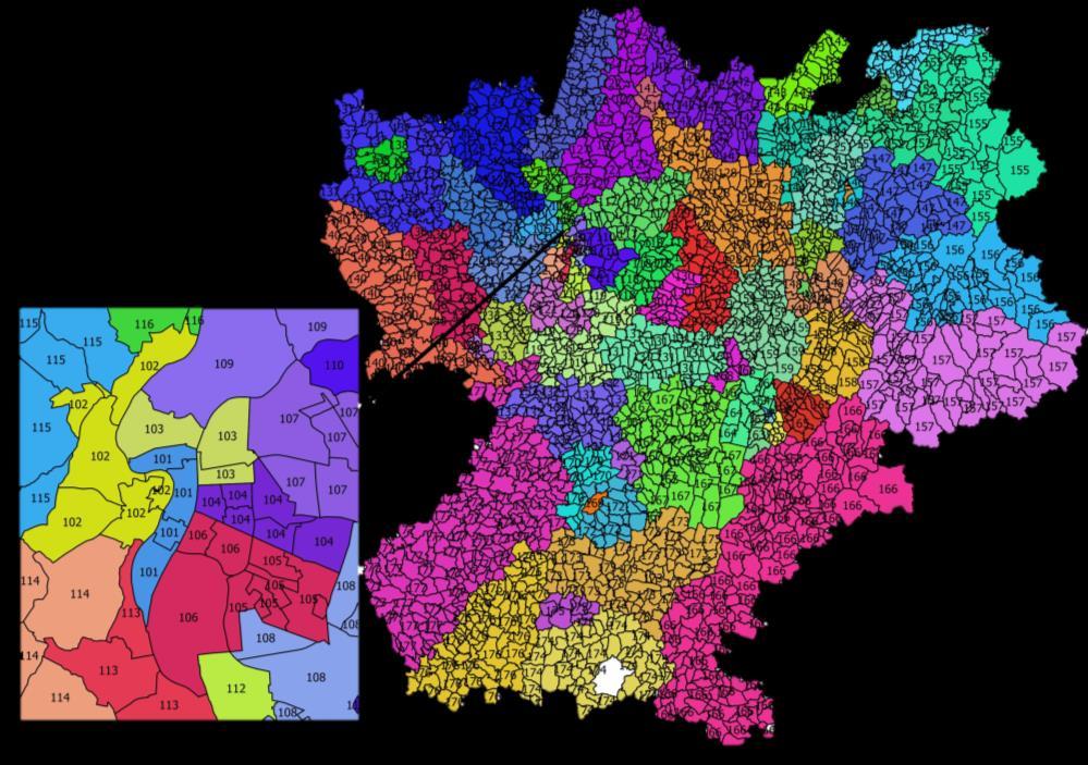


15 DATA ANALYSIS : geographic zoning systems 15 EDR survey : 77 zones ( sectors ) Cellular network

16 OD Matrices construction: Method 16 o EDR Sector aggregation i. Construct a conversion matrix to convert 77 zoning system to 14 zoning system ii. Aggregate trips and generate OD matrix (14 *14 OD pairs) iii. Compare with OD estimations of the travel survey


17 OD Matrices : Results 17 o Linear regression models: Comparison between mobile phone and EDR Survey OD estimates delta t : minimum stationary time Expansion factor: C expansion = Population of RA region Nb of moving users using network
18 Conclusion and Future work 18 Proposals Generation of the Origin-Destination matrices from mobile phone data Comparison with O-D matrices generated from the household travel survey conducted in the Rhône-Alpes region (EDR 2015) Futur work Improve OD estimation by including the number of home locations per sector in the expansion factor formula Study and extract individual trajectories at fine-grained scale (eg. city level)
19 19 Thank you! Questions?
Chattanooga Cell Phone External O-D Matrix Development
 Chattanooga Cell Phone External O-D Matrix Development Process and Findings Presented to Tennessee Model Users Group (TNMUG) November 10, 2011 1 Background Chattanooga RPA/CHCNGA TPO wanted to update their
Activity-Based Human Mobility Patterns Inferred from Mobile Phone Data: A Case Study of Singapore
 Activity-Based Human Mobility Patterns Inferred from Mobile Phone Data: A Case Study of Singapore By: Shan Jiang, Joseph Ferreira, Jr., and Marta C. Gonzalez Published in: 2017 Presented by: Masijia Qiu
A New Framework for Development of Time Varying OD Matrices Based on Cellular Phone Data
 A New Framework for Development of Time Varying OD Matrices Based on Cellular Phone Data Corresponding Author: Jingtao Ma, Mygistics Inc. 9755 SW Barnes Rd Suite 550 Portland, OR 97225 Phone +01-503-575-2191,
MOBILE POSITIONING DATA: A NEW DATA SOURCE FOR MEASURING Population Mobility
 MOBILE POSITIONING DATA: A NEW DATA SOURCE FOR MEASURING Population Mobility Edi Setiawan Population and Labor Mobility Statistics Division BPS-Statististics Indonesia BIG DATA Feasibility on using For
HOW TO USE TECHNOLOGY TO UNDERSTAND HUMAN MOBILITY IN CITIES? Stefan Seer Mobility Department Dynamic Transportation Systems
 HOW TO USE TECHNOLOGY TO UNDERSTAND HUMAN MOBILITY IN CITIES? Stefan Seer Mobility Department Dynamic Transportation Systems Sustainable transport planning requires a deep understanding on human mobility
TrajAnalytics: A software system for visual analysis of urban trajectory data
 TrajAnalytics: A software system for visual analysis of urban trajectory data Ye Zhao Computer Science, Kent State University Xinyue Ye Geography, Kent State University Jing Yang Computer Science, University
Statistical Inference on Mobile Phone Network Data
 Statistical Inference on Mobile Phone Network Data European Forum for Geography and Statistics (EFGS 2018) Martijn Tennekes October 16-18, 2018 Predecessors of Mobile Phones Walkie-talkie Car telephone
Cell Phone Location Data for Travel Behavior Analysis
 Cell Phone Location Data for Travel Behavior Analysis NCHRP 08-95 presented to Southeast Florida FSUTMS User Group presented by Cambridge Systematics, Inc. Kimon Proussaloglou March 1 15, 2019 The Next
ITS Canada Annual Conference and General Meeting. May 2013
 Evaluation of Travel Time Data Collection Technologies: An Innovative Approach for a Large- Scale Network ITS Canada Annual Conference and General Meeting May 2013 Study Steps Obtain the traffic data from
DS595/CS525: Urban Network Analysis --Urban Mobility Prof. Yanhua Li
 Welcome to DS595/CS525: Urban Network Analysis --Urban Mobility Prof. Yanhua Li Time: 6:00pm 8:50pm Wednesday Location: Fuller 320 Spring 2017 2 Team assignment Finalized. (Great!) Guest Speaker 2/22 A
By Aroon Aungsuyanon Bin Ran University of Wisconsin-Madison s and s David Boyce Northwestern University
 An Exploratory Analysis of PAS Characteristics in Solving the Static Deterministic User Equilibrium Traffic Assignment Problem on a Large Scale Urban Network By Aroon Aungsuyanon Bin Ran University of
Evaluating long-distance travel patterns in Israel by tracking cellular phone positions
 JOURNAL OF ADVANCED TRANSPORTATION Published online 9 February 2011 in Wiley Online Library (wileyonlinelibrary com)..170 Evaluating long-distance travel patterns in Israel by tracking cellular phone positions
Data for Development Challenge Senegal. Book of Abstracts: Scientific Papers
 Data for Development Challenge Senegal Book of Abstracts: Scientific Papers At Organized by Sponsored by www.d4d.orange.com / Tweeter : @O4Dev Contact: Nicolas De Cordes, Orange, VP Marketing Anticipation,
A Novel Method for Activity Place Sensing Based on Behavior Pattern Mining Using Crowdsourcing Trajectory Data
 A Novel Method for Activity Place Sensing Based on Behavior Pattern Mining Using Crowdsourcing Trajectory Data Wei Yang 1, Tinghua Ai 1, Wei Lu 1, Tong Zhang 2 1 School of Resource and Environment Sciences,
Data Model and Management
 Data Model and Management Ye Zhao and Farah Kamw Outline Urban Data and Availability Urban Trajectory Data Types Data Preprocessing and Data Registration Urban Trajectory Data and Query Model Spatial Database
Supporting Growth in Society and Industry Using Statistical Data from Mobile Terminal Networks Overview of Mobile Spatial Statistics
 Supporting Growth in Society and Industry Using Statistical Data from Mobile Terminal Networks Overview of Mobile Spatial Statistics MSS Estimation Privacy Protection Mobile Spatial Statistics Supporting
Using Telecom Data to Track Movement at High Spatial and Temporal Frequencies. Sveta Milusheva DIME World Bank
 Using Telecom Data to Track Movement at High Spatial and Temporal Frequencies Sveta Milusheva DIME World Bank Population Movement One of the main goals of transportation infrastructure projects is to improve
Young Researchers Seminar 2009
 Young Researchers Seminar 2009 Torino, Italy, 3 to 5 June 2009 Routing strategies minimizing travel times within multimodal transport networks Contents Motivations and objectives Network model Travel time
The Cellular Interceptor CC2800 Series
 The Cellular Interceptor CC2800 Series Operational Parameters The Target Mode enables the user to direct cellular interception by variables such as the IMSI, TMSI, or cellular phone number of the suspect.
Mining massive geographic data. Jameson Toole & Yingxiang Yang! Human Mobility and Networks Lab MIT
 Mining massive geographic data Jameson Toole & Yingxiang Yang! Human Mobility and Networks Lab MIT The question. How do you build a richer Google Maps? With data! Call Detail Records (CDRs) Every time
Module 8. Use of Double Geography datasets within SASPAC
 Module 8 Use of Double Geography datasets within SASPAC SASPAC Training Double Geography datasets Introduction The standard datasets supplied by the Census Offices are one-dimensional in a geographic
Mobile Sensing for Data-Driven Mobility Modeling
 Mobile Sensing for Data-Driven Mobility Modeling Kashif Zia Katayoun Farrahi Department of Computing Goldsmiths, University of London, UK Arshad Muhammad Dinesh Kumar Saini Abstract The use of mobile sensed
Inferring Maps from GPS Data
 Inferring Maps from GPS Data 1. Why infer maps from GPS traces? 2. Biagioni/Eriksson algorithm 3. Evaluation metrics 4. Similar approaches: satellite images, map update 5. Lab 4 1 2 3 OpenStreetMap Licensed
DRAFT THE RESILIENCE TO DISASTERS AND EMERGENCIES INDEX (REDI) Constantine E. Kontokosta, PhD, PE, AICP, LEED AP NYU CUSP & NYU Poly & NYU Schack
 Constantine E. Kontokosta, PhD, PE, AICP, LEED AP NYU CUSP & NYU Poly & NYU Schack") THE RESILIENCE TO DISASTERS AND EMERGENCIES INDEX (REDI) A Unified Index of Resilience Capacity and Survivability Update: March 27, 2014 Constantine E. Kontokosta, PhD, PE, AICP, LEED AP NYU CUSP & NYU
THE RESILIENCE TO DISASTERS AND EMERGENCIES INDEX (REDI) A Unified Index of Resilience Capacity and Survivability Update: March 27, 2014 Constantine E. Kontokosta, PhD, PE, AICP, LEED AP NYU CUSP & NYU
Sanitization of call detail records via differentially-private Bloom filters
 Sanitization of call detail records via differentially-private Bloom filters Mohammad Alaggan Helwan University Joint work with Sébastien Gambs (Université de Rennes 1 - Inria / IRISA), Stan Matwin and
Lecture 6: GIS Spatial Analysis. GE 118: INTRODUCTION TO GIS Engr. Meriam M. Santillan Caraga State University
 Lecture 6: GIS Spatial Analysis GE 118: INTRODUCTION TO GIS Engr. Meriam M. Santillan Caraga State University 1 Spatial Data It can be most simply defined as information that describes the distribution
SHRP2 C10: Jacksonville
 SHRP2 C10: Jacksonville Partnership to Develop an Integrated Advanced Travel Demand Model and a Fine grained Timesensitive Network Presented by: Stephen Lawe Key Agency Partners: Florida Department of
ARE UBIQUITOUS TECHNOLOGIES THE FUTURE VEHICLE FOR TRANSPORTATION PLANNING : AN ANALYSIS ON VARIOUS METHODS FOR ORIGIN DESTINATION
 ARE UBIQUITOUS TECHNOLOGIES THE FUTURE VEHICLE FOR TRANSPORTATION PLANNING : AN ANALYSIS ON VARIOUS METHODS FOR ORIGIN DESTINATION Tapas Saini, S.V.Srikanth & Amritanshu Sinha Centre for Development of
Mobility Management (cont.)
") CPET 565/CPET 499 Mobile Computing Systems Lecture 5 Mobility Management of Based on the Text used in the course: Fundamentals of Mobile & Pervasive Computing, 005, by Frank Adelstein, et. al, from McGraw-Hill
CPET 565/CPET 499 Mobile Computing Systems Lecture 5 Mobility Management of Based on the Text used in the course: Fundamentals of Mobile & Pervasive Computing, 005, by Frank Adelstein, et. al, from McGraw-Hill
Des Moines Area Regional Transit Non Rider Survey
 Moines Area Regional Transit Non Rider Survey helping organizations make better decisions since 1982 Findings Report Submitted to the Moines Area Regional Transit Authority by: ETC Institute 725 W. Frontier
Stability analysis of Activity-Based models
 Stability analysis of Activity-Based models Case study of the Tel Aviv Transportation Model Shlomo Bekhor Technion, Israel Institute of Technology Leonid Kheifits Independent Consultant, Israel Michael
Offloading Floating Car Data through V2V Communications
 Offloading Floating Car Data through V2V Communications Razvan Stanica (INSA Lyon), Marco Fiore (IEIIT - CNR), Francesco Malandrino (Politecnico di Torino) 3èmes Journées Nationales des Communications
Inferring Correlation between User Mobility and App Usage in Massive Coarse-grained Data Traces
 153 Inferring Correlation between User Mobility and App Usage in Massive Coarse-grained Data Traces ZHENG LU, University of Tennessee, USA YUNHE FENG, University of Tennessee, USA WENJUN ZHOU, University
April 13, Honorable John Hickenlooper Governor, State of Colorado 136 State Capitol Building 200 East Colfax Avenue Denver, CO 80203
 April 13, 2017 Honorable John Hickenlooper Governor, State of Colorado 136 State Capitol Building 200 East Colfax Avenue Denver, CO 80203 RE: Support for House Bill 1193 Small Wireless Infrastructure Dear
Data as a Key Enabler For Future Mobility Opportunities for the Region and Roles Of Governments
 Data as a Key Enabler For Future Mobility Opportunities for the Region and Roles Of Governments Dr Stephane Dreher Transport Data and Statistics Advisor United Nations Development Programme Ministry of
Big data for measuring the information society
 ITU Regional Workshop on ICT Statistics Manama, Bahrain 26-27 March 2018 Big data for measuring the information society Ivan Vallejo Vall ICT Data and Statistics Division International Telecommunication
Takeaways in Large-scale Human Mobility Data Mining. Guangshuo Chen, Aline Carneiro Viana, and Marco Fiore
 Takeaways in Large-scale Human Mobility Data Mining Guangshuo Chen, Aline Carneiro Viana, and Marco Fiore Human Mobility Investigation Locations time General Networking Prediction Reconstruction Characterization
Operator characteristics
 RÉPUBLIQUE FRANÇAISE July 2013 Key figures for electronic communications and postal markets in France Figures for 2012 Operator characteristics Unless otherwise stated, the figures in this document are
Urban Sensing Using Mobile Phones Network Data: A Survey of Research
 Urban Sensing Using Mobile Phones Network Data: A Survey of Research FRANCESCO CALABRESE IBM Research Ireland, Dublin, Ireland LAURA FERRARI Dipartimento di Scienze e Metodi dell Ingegneria, University
The goal of this task is to assemble the input data required to deliver national accessibility reports and
 The goal of this task is to assemble the data required to deliver national accessibility reports and blocklevel accessibility datasets to each of the project participants. Subsequent tasks in this project
SOLUTIONS FOR MOBILITY OF 21ST CENTURY RESEACH AGENDA
 SOLUTIONS FOR MOBILITY OF 21ST CENTURY RESEACH AGENDA Martin Hájek Head manager, Centre RODOS/VSB TECHNICAL UNIVERSITY OF OSTRAVA Jiří Novobilský, Director; CE-TRAFFIC Mobility 20 June 2017 1 rodos Academic
Making Smart Use of Geo-location Data
 Making Smart Use of Geo-location Data Using geolocation in a trustworthy and compliant way Simon.Hania@tomtom.com Trends that threaten trust 2 Connected cars with downloadable apps Location services, cloud,
IP Paging Considered Unnecessary:
 IP Paging Considered Unnecessary: Mobile IPv6 and IP Paging for Dormant Mode Location Update in Macrocellular and Hotspot Networks James Kempf DoCoMo USA Communications Labs 181 Metro Drive, Suite 3 San
A population grid for Andalusia Year Institute of Statistics and Cartography of Andalusia (IECA) Sofia (BU), 24 th October 2013
 Sofia (BU), 24 th October 2013") A population grid for Andalusia Year 2013 Institute of Statistics and Cartography of Andalusia (IECA) Sofia (BU), 24 th October 2013 IECA project. Population grid cells sized 250 x 250m for Andalusia 1.
A population grid for Andalusia Year 2013 Institute of Statistics and Cartography of Andalusia (IECA) Sofia (BU), 24 th October 2013 IECA project. Population grid cells sized 250 x 250m for Andalusia 1.
Design Considerations for Real-time Arterial Performance Measurement Systems Using Transit Bus Probes
 Design Considerations for Real-time Arterial Performance Measurement Systems Using Transit Bus Probes Abraham Emmanuel & David Zavattero Chicago Department of Transportation Project Goals Estimate traffic
Controlling user groups in traffic
 Controlling user groups in traffic Jaap Vreeswijk 1, Luc Wismans 2, Bas Tutert 3 1. Imtech Traffic & Infra, Basicweg 16, 3821 BR Amersfoort, The Netherlands, Phone: +31 33 454 1724, Mail: jaap.vreeswijk@imtech.com
Clustering methods for the automatic design of traffic zones
 SIDT 2009 International Conference 1 Clustering methods for the automatic design of traffic zones Guido Gentile 1, Daniele Tiddi 1 1 DITS - Dipartimento di Idraulica Trasporti e Strade, Sapienza Università
Research on Destination Prediction for Urban Taxi based on GPS Trajectory
 Available online at www.ijpe-online.com Vol. 13, No. 4, July 2017, pp. 530-539 DOI: 10.23940/ijpe.17.04.p20.530539 Research on Destination Prediction for Urban Taxi based on GPS Trajectory Meng Zhang a,
Trip Distribution Models in TransCAD. Murtaza Haider Tel: , ext. 2480
 Trip Distribution Models in TransCAD Murtaza Haider murtaza.haider@ryerson.ca Tel: 416.979.5000, ext. 2480 Trip Distribution Procedures Goal: understand how to use TransCAD to: Generate inputs for trip
Estimation of Urban Commuting Patterns Using Cellphone Network Data
 Estimation of Urban Commuting Patterns Using Cellphone Network Data Vanessa Frias-Martinez Telefonica Research, Madrid, Spain vanessa@tid.es Cristina Soguero Telefonica Research, Madrid, Spain soguero@tid.es
Mobile Travel Trends in China. Nov 2013
 Mobile Travel Trends in China Nov 2013 Qunar is the world s largest Chinese travel platform Background Monthly Unique Visitors (in mm) Founded: 2005 Headquarters: Beijing, China Employees: 1699 Listed:
Testimony of Lisa McCabe Director, State Legislative Affairs CTIA Support for Michigan Senate Bill 637 November 2, 2017
 Testimony of Lisa McCabe Director, State Legislative Affairs CTIA Support for Michigan Senate Bill 637 November 2, 2017 Before the Michigan Senate Energy and Technology Committee Chairman Nofs and members
Introduction to and calibration of a conceptual LUTI model based on neural networks
 Urban Transport 591 Introduction to and calibration of a conceptual LUTI model based on neural networks F. Tillema & M. F. A. M. van Maarseveen Centre for transport studies, Civil Engineering, University
Mobility Models. Larissa Marinho Eglem de Oliveira. May 26th CMPE 257 Wireless Networks. (UCSC) May / 50
 May / 50") Mobility Models Larissa Marinho Eglem de Oliveira CMPE 257 Wireless Networks May 26th 2015 (UCSC) May 2015 1 / 50 1 Motivation 2 Mobility Models 3 Extracting a Mobility Model from Real User Traces 4 Self-similar
Mobility Models Larissa Marinho Eglem de Oliveira CMPE 257 Wireless Networks May 26th 2015 (UCSC) May 2015 1 / 50 1 Motivation 2 Mobility Models 3 Extracting a Mobility Model from Real User Traces 4 Self-similar
Estimation of Urban Commuting Patterns Using Cellphone Network Data
 Estimation of Urban Commuting Patterns Using Cellphone Network Data Vanessa Frias-Martinez Telefonica Research, Madrid, Spain vanessa@tid.es Cristina Soguero Telefonica Research, Madrid, Spain soguero@tid.es
Managed Lane owner decision needed San Mateo County s options Understanding revenues & costs Pros & cons of County s options Proposed next steps
 San Mateo County Transportation Authority Meeting August 2, 2018 1 OVERVIEW Managed Lane owner decision needed San Mateo County s options Understanding revenues & costs Pros & cons of County s options
Evaluation of Roadside Surveys for Freight Transport Data at Border Crossings
 Evaluation of Roadside Surveys for Freight Transport Data at Border Crossings Wirach Hirun #1 # Department of Civil and Environmental Engineering, Kasetsart University Chalermprakiat Sakon Nakhon Province
The Practical Side of Cell Phones as Traffic Probes
 The Practical Side of Cell Phones as Traffic Probes The information contained in this document is considered proprietary, and may not be reproduced or redistributed without the consent of Delcan Inc. Cell
Temporally Adaptive A* Algorithm on Time Dependent Transportation Network
 Temporally Adaptive A* Algorithm on Time Dependent Transportation Network Nianbo Zheng, Feng Lu Institute of Geographic Sciences and Natural Resources Research Chinese Academy of Sciences Beijing, 100101,
Contact: Ye Zhao, Professor Phone: Dept. of Computer Science, Kent State University, Ohio 44242
 Table of Contents I. Overview... 2 II. Trajectory Datasets and Data Types... 3 III. Data Loading and Processing Guide... 5 IV. Account and Web-based Data Access... 14 V. Visual Analytics Interface... 15
Redistricting and Geographic Deployment at the Ottawa Police Service Esri Canada User Conference Ottawa October 12, 2017
 Redistricting and Geographic Deployment at the Ottawa Police Service Esri Canada User Conference Ottawa October 12, 2017 Introduction Alyson Yaraskovitch, B.A., M.A. Crime Intelligence Analyst Ottawa Police
Spatio-Temporal Routing Algorithms Panel on Space-Time Research in GIScience Intl. Conference on Geographic Information Science 2012
 Spatio-Temporal Routing Algorithms Panel on Space-Time Research in GIScience Intl. Conference on Geographic Information Science 0 Shashi Shekhar McKnight Distinguished University Professor Department of
Implementation and Evaluation of Mobility Models with OPNET
 Lehrstuhl Netzarchitekturen und Netzdienste Institut für Informatik Technische Universität München Implementation and Evaluation of Mobility Models with OPNET Abschlussvortrag zur Masterarbeit von Thomas
CrowdPath: A Framework for Next Generation Routing Services using Volunteered Geographic Information
 CrowdPath: A Framework for Next Generation Routing Services using Volunteered Geographic Information Abdeltawab M. Hendawi, Eugene Sturm, Dev Oliver, Shashi Shekhar hendawi@cs.umn.edu, sturm049@umn.edu,
Abstract
 Australasian Transport Research Forum 2013 Proceedings 2-4 October 2013, Brisbane, Australia Publication website: http://www.patrec.org/atrf.aspx Minimising GEH in Static OD estimation Aleix Ruiz de Villa
TRAFFIC INFORMATION SERVICE IN ROAD NETWORK USING MOBILE LOCATION DATA
 TRAFFIC INFORMATION SERVICE IN ROAD NETWORK USING MOBILE LOCATION DATA Katsutoshi Sugino *, Yasuo Asakura **, Takehiko Daito *, Takeshi Matsuo *** * Institute of Urban Transport Planning Co., Ltd. 1-1-11,
PARAMETERIZATION OF THE SWIM MOBILITY MODEL USING CONTACT TRACES
 1 PARAMETERIZATION OF THE SWIM MOBILITY MODEL USING CONTACT TRACES OMNeT++ Summit 2017, Bremen Zeynep Vatandas, Manikandan Venkateswaran, Koojana Kuladinithi, Andreas Timm-Giel Hamburg University of Technology
Understanding Human Mobility. Mirco Nanni. Knowledge Discovery and Data Mining Lab (ISTI-CNR & Univ. Pisa) kdd.isti.cnr.
 kdd.isti.cnr.") BigData@Mobility Understanding uman Mobility Mirco Nanni Knowledge Discovery and Data Mining Lab (ISTI-CNR & Univ. Pisa) kdd.isti.cnr.it BigData @ Mobility: Objectives Infer human mobility from mobility
BigData@Mobility Understanding uman Mobility Mirco Nanni Knowledge Discovery and Data Mining Lab (ISTI-CNR & Univ. Pisa) kdd.isti.cnr.it BigData @ Mobility: Objectives Infer human mobility from mobility
5G Priorities. Luke Ibbetson, R&D Director Vodafone Group. C1: Public
 5G Priorities Luke Ibbetson, R&D Director Vodafone Group C1: Public Many factors will contribute to increased mobile usage Network Evolution Customer Evolution Device Evolution Service Evolution 2000 225
Error Assessment for Emerging Traffic Data Collection Devices
 Error Assessment for Emerging Traffic Data Collection Devices Ted Bailey, WSDOT Ron Vessey, WSDOT Bahar Namaki, Aalborg Univ. Jonathan Corey, UW Yegor Malinovskiy, UW Yinhai Wang, UW 1 Presentation Outline
INTELLIGENT TRAFFIC MANAGEMENT FOR INDIA Phil Allen VP Sales APAC
 INTELLIGENT TRAFFIC MANAGEMENT FOR INDIA 2017-05 Phil Allen VP Sales APAC Phil.Allen@tomtom.com OUR BUSINESS TODAY 4,700 employees in 35 countries LICENSING Delivering digital maps and dynamic content
On Mobile Traffic Distribution over Cellular Backhauling Network Nodes
 On Mobile Traffic Distribution over Cellular Backhauling Network Nodes Sandesh Uppoor, Cezary Ziemlicki, Stefano Secci, Zbigniew Smoreda Orange Labs, 92794 Issy-les-Moulineaux, France. Email: firstname.lastname@orange.com
Kyeil Kim, Guy Rousseau, Kyung-Hwa Kim & David D Onofrio
 Kyeil Kim, Guy Rousseau, Kyung-Hwa Kim & David D Onofrio 4 th International Conference on Innovations in Travel Modeling April 30-May 2, 2012 Tampa, Florida Anti-intellectualism nurtured by the false notion
URBY.Sense Urban mobility analysis and prediction for non-routine scenarios using digital footprints
 CISMOB - Cooperative information platform for low carbon and sustainable mobility Interreg Europe 2nd Regional Stakeholder Meeting - Portugal Centro 07-04-2017 URBY.Sense Rui Gomes u Agenda u Project summary
Good practice: Development of a Mobility Monitoring Centre (MMC) for Thessaloniki
 for Thessaloniki") Integrated REgional Action Plan For Innovative, Sustainable and LOw CaRbon Mobility Good practice: Development of a Mobility Monitoring Centre (MMC) for Thessaloniki The MMC of Thessaloniki objective The
Integrated REgional Action Plan For Innovative, Sustainable and LOw CaRbon Mobility Good practice: Development of a Mobility Monitoring Centre (MMC) for Thessaloniki The MMC of Thessaloniki objective The
Routenwahl im IV - Teil 2
 Routenwahl im IV - Teil 2 Klaus Nökel TRB Innovations in Travel Modeling Conference 2014 AGGREGATE TOUR BASED MODELING, A PRAGMATIC STEP-UP FROM THE 4-STEP MODEL www.ptvag.com Chetan Joshi Klaus Noekel
PoP Level Mapping And Peering Deals
 PoP Level Mapping And Peering Deals Mapping Internet Methodology Data Collection IP Classification to PoP PoP Geolocation PoP locations on Peering estimations Outline Internet Service Providers ISPs are
Cause/reason (if currently known)
") The Affirmatively Furthering Fair Housing Data and Mapping Tool (AFFH-T): for AFFH-T Release 4.1 Published: December 20, As part of its efforts to support program participants in conducting their Assessments
The Affirmatively Furthering Fair Housing Data and Mapping Tool (AFFH-T): for AFFH-T Release 4.1 Published: December 20, As part of its efforts to support program participants in conducting their Assessments
Smart Card Data in Public Transport
 Department of Technology & Operations Management Smart Card Data in Public Transport Paul Bouman Also based on work of: Evelien van der Hurk, Timo Polman, Leo Kroon, Peter Vervest and Gábor Maróti Complexity
Analysis of Crowd Movement Based on Mobile Phone Signaling
 Analysis of Crowd Movement Based on Mobile Phone Signaling Yanhao Luo, Lu Zhang * School of Electrical and Information Engineering, Quzhou University, Quzhou, 324000, China Abstract *Corresponding Author:
Validation of Simulation Models Using Vehicle Trajectories. TRB Annual Meeting January 11, 2015
 Validation of Simulation Models Using Vehicle Trajectories TRB Annual Meeting January 11, 2015 1 Overview Project Objectives and the Project Team State of Practice for Aggregate Calibration Trajectory
The Sharing Economy & Managed Travel? Hail Yes!
 The Sharing Economy & Managed Travel? Hail Yes! The Ohio Valley & Michigan Business Travel Association Joint Education Day Meeting Susan Steinbrink Senior Research and Corporate Market Analyst October
GALLUP NEWS SERVICE GALLUP POLL SOCIAL SERIES: VALUES AND BELIEFS
 GALLUP NEWS SERVICE GALLUP POLL SOCIAL SERIES: VALUES AND BELIEFS -- FINAL TOPLINE -- Timberline: 937008 IS: 727 Princeton Job #: 16-05-006 Jeff Jones, Lydia Saad May 4-8, 2016 Results are based on telephone
Comparative Evaluation of Synthetic Dataset Generation Methods
 Comparative Evaluation of Synthetic Dataset Generation Methods Ashish Dandekar, Remmy A. M. Zen, Stéphane Bressan December 12, 2017 1 / 17 Open Data vs Data Privacy Open Data Helps crowdsourcing the research
Transportation Mode Inference from Anonymized and Aggregated Mobile Phone Call Detail Records
 Transportation Mode Inference from Anonymized and Aggregated Mobile Phone Call Detail Records Huayong Wang, Francesco Calabrese, Giusy Di Lorenzo, Carlo Ratti Abstract Transportation mode inference is
Transport Modelling in OmniTRANS. Exercise book
 Transport Modelling in OmniTRANS Exercise book Course and Contact Information Course: Exercise book: Transport Modelling in OmniTRANS Course Description: This exercise book has been developed to offer
INDIAN INSTITUTE OF MANAGEMENT CALCUTTA WORKING PAPER SERIES. WPS No. 644/ August A Markov-based Diurnal Mobility Model for 3G Cellular Networks
 INDIAN INSTITUTE OF MANAGEMENT CALCUTTA WORKING PAPER SERIES WPS No. 644/ August 2009 A Markov-based Diurnal Mobility Model for 3G Cellular Networks by Samir K Sadhukhan SSA, IIM Calcutta, Diamond Harbour
CIE4801 Transportation and spatial modelling Beyond the 4-step model
 CIE4801 Transportation and spatial modelling Beyond the 4-step model Erik de Romph, Transport & Planning 31-08-18 Delft University of Technology Challenge the future Multi disciplinary 2 Contents Input
Defining and Measuring Urban Conges on
 Primer on Defining and Measuring Urban Conges on Introduc on Traffic congestion has become a major challenge in most urban areas. In recent years, the development of measures to mitigate traffic congestion
NMOSE GPCD CALCULATOR
 NMOSE CALCULATOR It should be noted that all the recorded data should be from actual metered results and should not include any estimates. Gallons per Capita - v2.4 Beta Release Date: Mar, 16, 29 This
Introduction to R Programming
 Course Overview Over the past few years, R has been steadily gaining popularity with business analysts, statisticians and data scientists as a tool of choice for conducting statistical analysis of data
Data Driven Analysis in Transportation Systems
 Data Driven Analysis in Transportation Systems http://imsc.usc.edu/ Ugur Demiryurek, Ph.D. Associate Director, Integrated Media Systems Center (IMSC) Viterbi School of Engineering University of Southern
Using GPS Based Origin-Destination Data to Improve Traffic Studies. Michael R. Wahlstedt, PE, PTOE OTEC October 11, 2017
 Using GPS Based Origin-Destination Data to Improve Traffic Studies Michael R. Wahlstedt, PE, PTOE OTEC October 11, 2017 Overview Benefits of using O-D data for traffic analysis, particularly for operational
C-ITS future opportunities and challenges
 C-ITS future opportunities and challenges CIMEC workshop: C-ITS standardisation requirements for the urban environment, 12 September 2016, Brussel Bahar Namaki Araghi, Eng., PhD ITS Project Manager, City
DS504/CS586: Big Data Analytics Data Pre-processing and Cleaning Prof. Yanhua Li
 Welcome to DS504/CS586: Big Data Analytics Data Pre-processing and Cleaning Prof. Yanhua Li Time: 6:00pm 8:50pm R Location: KH116 Fall 2017 Merged CS586 and DS504 Examples of Reviews/ Critiques Random
DS504/CS586: Big Data Analytics Data Management Prof. Yanhua Li
 Welcome to DS504/CS586: Big Data Analytics Data Management Prof. Yanhua Li Time: 6:00pm 8:50pm R Location: KH 116 Fall 2017 First Grading for Reading Assignment Weka v 6 weeks v https://weka.waikato.ac.nz/dataminingwithweka/preview
PureEngage Cloud Release Note. Outbound
 PureEngage Cloud Release Note Outbound 1/2/2018 Outbound Note: Not all changes listed below may pertain to your deployment. November 13, 2017 (14.15.0) October 23, 2017 (14.14.0) September 21, 2017 (14.13.0)
PTV VISUM 16 NEW FEATURES AT A GLANCE
 PTV VISUM 16 NEW FEATURES AT A GLANCE Copyright: 2016 PTV AG, Karlsruhe PTV Visum is a trademark of PTV AG All brand or product names in this documentation are trademarks or registered trademarks of the
Georeferencing. Georeferencing: = linking a layer or dataset with spatial coordinates. Registration: = lining up layers with each other
 Georeferencing How do we make sure all our data layers line up? Georeferencing: = linking a layer or dataset with spatial coordinates Registration: = lining up layers with each other Rectification: The
AN AGENT-BASED APPROACH TO THE SIMULATION OF PEDESTRIAN MOVEMENT AND FACTORS THAT CONTROL IT
 AN AGENT-BASED APPROACH TO THE SIMULATION OF PEDESTRIAN MOVEMENT AND FACTORS THAT CONTROL IT 1. Why another model? Planned as part of a modular model able to simulate rent rate / land value / land use