The Hague Smartline: support for the visually impaired
|
|
|
- Kerry Walker
- 6 years ago
- Views:
Transcription


1 The Hague Smartline: support for the visually impaired Toine Molenschot City of The Hague Department for Urban Development, Abstract In The Hague, the third largest city in the Netherlands, many visitors and local inhabitants need to visit a location between the Central Railway station and the Dutch Parliament. The local council aims to increase the accessibility of the city, and has started up the SmartLine initiative. The SmartLine guides visually impaired people along this track. The application consists of the combination of an epoxy line for walking and push and pull information provided for the user during his or her walk anywhere on the track. The information provided involves navigation information and information on the buildings and the public transport platforms alongside, and is presented on audio channel via a smartphone or PDA. A user panel has provided information on user requirements. A prepilot was organized to test the reliability of the system, and a pilot study has recently been carried out to evaluate the functionality and usability of the system. In the paper, the functionality and roadmap to realise of the SmartLine is reported. The outcomes as well as the design of the pilot study will be presented in an other session. 1
2 1. INTRODUCTION The city of The Hague Visual impaired in the city centre THE SMARTLINE The development procedure for Smartline Development of the functionality of the Smartline Development of the user interface of the Smartline REALIZATION OF THE SMARTLINE Project limitations...error! Bookmark not defined. 3.2 ASK-IT Pilot SmartLine...Error! Bookmark not defined. 2
3 1. Introduction In the city The Hague, an innovation in the field of support for the mobility impaired has been developed and realized. 1.1 The city of The Hague The Hague is the third large city of the Netherlands, residence of the National Government and the Royal family. The International Criminal Court, The Peace Palace, the International Criminal Tribunal for the former Yugoslavia and Europol are just a few of the organizations which contribute to The Hague s reputation as the International City of Peace and Justice. The city attracts tourists, both from the Netherlands, but also from all over the world. Furthermore there is a considerable amount of visitors to the city who need to pay visits to one of the ministries, the parliament or any of the (international) offices. Thirdly, of course there are the local people needing to visit the main city buildings. And all of them wishing to be able to walk around, do shopping and find The Hague an accessible city. 1.2 Visual impaired in the city centre For all those people with limitations in eye sight, there are considerable problems in finding their way safely and effectively. There is a spacious pedestrian area from the central railway station to the City Hall but it is made out of special stones that make it a plane area without clear markers that might be used as a reference. Currently, a physical system made of epoxy lines is being developed to guide them from the central railway station to the Dutch parliament, passing various main public buildings. These buildings include the ministry of Health, Welfare and Sport, the ministry of Housing, Spatial Planning and the Environment, the ministry of Internal Affairs, Ministry of Justice, the City Hall, a Concert Hall and the City Library. 2. The Smartline The Smartline is aimed to support visually impaired people by an electronic guideline: to be aware of their environment to see in a virtual way, to make a choice where to go and to access the buildings / sites of their interest. The Smartline specifically is aimed at guiding visually impaired people from the Central Station in The Hague to the buildings of the Dutch Parliament in order to allow them 3
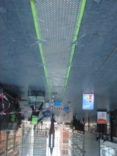
 and central station (right).")
 Only using the")
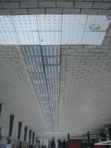
4 to visit the meetings of the House of Commons. Next to these track five ministries, the town hall, the city library and a concert hall are situated (fig 1.). Figure 1. Guideline for visual impaired, between national parliament (left) and central station (right). Aerial view: yellow line is guideline, green line are sideways to buildings (1= National Parliament, 2= City Library, 3= City Hall, 4=Concert hall, 5= Ministry of Justice, 6=ministry of Internal Affairs, 7= ministry of Health, Welfare and Sport, 8=ministry of education, culture and science, 9=ministry of Housing, Spatial Planning and the Environment and 10=central station) Only using the combination of main track and side tracks on a physical guideline will become too complicated, so electronic assistance will be added to tell people where they are. The possibility of using standard PDA s or smart phones makes it possible testing the concept of the Smartline. The technology of DGPS is used for accurate positioning in combination with RFID for covered parts (orange coloured) and other parts of route as well as indoors where DGPS-reception is not possible. The Smartline incorporates the following modules: - Location Based Services (LBS) with PDA, using GPRS/UMTS/HSDPA for communication - GPS module standard in PDA, extra feature: RFID transmitter; - special external loudspeaker-set - RFID tags on the Smartline 4


 a label indicates the level of")
; the boxes are used")
5 - Website with accessibility information of all public buildings linked to server system Figure 2: Screen shot from the website with information on accessibility; for different items (e.g. parking, entrance, toilet, facilities for visual or hearing impairment) a label indicates the level of accessibility (from green/4 boxes = good accessible to red/1 box = not accessible); the boxes are used for people with colorblindness. 5

6 The service to the visual impaired user is branded RouteOnline and will be provided and marketed by ConnexIP. Figure 3. Sysyem concept of the Smartline. The user carries a mobile UMTS /GPRS device which connects to the mobile platform with local information. Via RFID tags accurate positioning for additional information is provided. The information can be updated at any moment and according to the latest changes. For instance, actual information on delays of busses or trams, tickets for museum or discounts of shops can be presented to the user. The user himself can decide the depth of the information he receives. In order to manage the information, ConnexIP has developed a user-friendly content management system (CMS). New and updated content can be stored, routes can be created, updated and mutated. Integration of value added services, webservices and push-information is possible. 6


7 2.1 The development procedure for Smartline The development of the Smartline is performed as follows : - Internal discussions with the City Council, ASK-It partner, technical partners and society for the blind: This local stakeholders group defined the scope of the project organisation and established the project organisation. - Start technical development: A feasibility study is held in order to decide what technology (or combination of technologies) is suitable for the specific technical needs of the project. - Reviewing deliverable on UI elements and metaphors, developed by USTUTT: From the ASK-It Use Case elements a range of UC s is chosen to incorporate in the Smartline Application Scenario. - Exploring the needs with a group of potential users: On-track field test of specific user needs to implement in the system. - Pre-pilot: A 2-day Field Test Trial with approximately 10 potential users on a small part of the track to test technical specifications of the Smartline system. - Establishing a user panel: Select approximately 20 potential users for the pilot phase. - Adjustments and further technical development: Evaluation of pre-pilot test results. - Pilot: Official ASK-IT Test for the Smartline system in The Hague starting June Adjustments: Evaluation of Pilot test results. In the current paper, the focus is particularly on the phase of development and realization of the SmartLine in order to be able to carry out the final pilot tests. 7
8 2.1.1 Development of the functionality of the Smartline The development started with the design of a virtual storyboard. Below, the functionality for the Use Case: Find current position is shown. ASK-IT Pre-pilot Storyboard Find current position _ PDA screen displays map (stored on server) with = default screen current position trajectory POI nearby _ PDA screen displays updated map (stored on server) every time the user moves _ PDA plays alert signal tone on map changes (stored on device) _ User is able to zoom, scroll, select POI options using keypad _ Note: not relevant to blind users Development of the user interface of the Smartline The development started with the design of a virtual storyboard. Below, the user interface for the Use Case: Identify POI nearby and Get info on POI (point of interest) is shown. ASK-IT Pre-pilot Storyboard Identify POI nearby _ PDA plays alert signal (stored on device) _ PDA screen displays navigation information and POI options (stored on server) _ PDA plays voice message with navigation information and POI options (stored on network, text to speech) _ User is able to scroll and select POI options using keypad ASK-IT Pre-pilot Storyboard Get info on POI _ User selects POI option with navigation keys _ PDA plays confirmation signal (stored on device) _ PDA screen displays information on POI option (stored on server) _ PDA plays voice message with information on POI option (stored on network, text to speech) _ User is able to scroll and select POI options using keypad 8


9 3. Realization of the SmartLine Initially the SmartLine route was projected between The Hague Central Station and the Parliament in the city centre. For this route GPS coverage and RFID tag positions were defined, based on experiences from the pre-tests. For each RFID-tag messages were composed for information to the user walking along the SmartLine, in both directions. This messages contain information about position, direction to follow and, in case of reaching a destination, accessibility of the object. Figure 4: Indication of GPS coverage and RFID-tag positions on the SmartLine track 9


10 3.1 Project limitations During the process in order to step into the phase to actually build the SmartLine, some necessary changes had to be made. First of all it was not possible to find a sustainable solution for putting the physical tactile line with epoxy onto the surface of the Turfmark route. Results from the pre-tests show that for some reason the line is eroding, what means that navigating on Turfmarkt was not possible. This problem will be solved when the Turfmarkt route is renovated within 2 years. A sustainable solution for the tactile line will then be integrated. Secondly the budget for realizing the complete SmartLine from Central Station to Parliament was not sufficient to cover all the predicted cost for the total project. It was decided to reduce the SmartLine to a part of the track where implementation was feasible and the budget could cover the costs. On this part of the SmartLine the ASK-IT pilot tests are kept. 3.2 ASK-IT Pilot SmartLine The SmartLine for the ASK-IT pilot test is now situated on a third of the original track between The Hague Central Station an the ministry of Health, Welfare and Sport. The test site exists of approximately 500 meters of guideline for the visual impaired, including 4 tram stops and a taxi stand near the railway station. Along the SmartLine there are 4 destinations: Central Station; ministry of Housing, Spatial Planning and Environment; ministry of Education, Culture and Science; ministry of Health, Welfare and Sport. In order to give the user directions on the Smartline to one of these destinations or a tram stop or taxi stand, there are 32 RFID tags needed. 10


11 As indicated in figure 4, most part of the test site track is covered, so GPS signals can not be received and therefore positioning by RFID is very important. 11


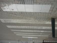
12 Apart from the part of the track in the ministry of Housing building, where still the epoxy line will be used, the SmartLine tactile track is build from prefab tiles. Also the RFID-tags are glued into tiles and integrated in the tactile line. 12
13 13

14 The SmartLine for the ASK-IT Pilot tests is now ready for use. Test are held in the first week of June and will continue in September The tests will be done with visual impaired users and results will be presented separately. Demonstrations of the SmartLine project and RouteOnline service are given at the ASK-IT Local Event in The Hague on June 12 th This event was organized by the City of The Hague and POLIS and was attended by approximately 40 delegates and stakeholders from The Hague and The Netherlands, together with some foreign visitors. 14
Open to Every Citizen
 Open to Every Citizen Feb. 2014 Information System Planning Bureau (Information Communication & Security Division) 20 million people (11 million residents and 9.5 million foreign visitors) in Seoul!!
SMART STATIONS IN SMART CITIES 6 th International Conference on Railway Stations Madrid, OCTOBER 2017
 SMART STATIONS IN SMART CITIES 6 th International Conference on Railway Stations Madrid, 19-21 OCTOBER 2017 PRM ON THE GO IN ITALIAN STATIONS Mauro Borsellino Service to Clients, Rete Ferroviaria Italiana,
Tap this button on your iphone to start the TomTom app.
 TomTom app 1. Getting started Getting started Tap this button on your iphone to start the TomTom app. The language used for buttons and menus in the TomTom app is the same as the language you selected
Smart City Solutions for Small City
 Smart City Solutions for Small City Jurijs Strods Jelgava, Latvia jurijs.strods@dome.jelgava.lv Nordic-Baltic solutions for smarter cities in the region 07.09.2017 JELGAVA CITY INFOGRAPHIC 2 Fourth largest
Press Release 27 October Successful conclusion of the 27th Annual Conference of the International Railway Safety Council
 Press Release 27 October 2017 Successful conclusion of the 27th Annual Conference of the International Railway Safety Council The 27th Annual Conference of the International Railway Safety Council (IRSC)
Digital GPS Based Audio Guide that Brings the Past to Life
 GUIDE@HAND: Digital GPS Based Audio Guide that Brings the Past to Life Zsolt László Márkus, Balázs Wagner The Computer and Automation Research Institute, Hungarian Academy of Sciences H-1111 Budapest,
Digital hospitality has a name: Sentido. Signposting and information services
 Digital hospitality has a name: Sentido Signposting and information services Welcome Even before being welcomed by your reception staff, your guests will feel at home thanks to the clear signposting on
FOSTERING THE WAY OF SAINT JAMES THROUGH PERSONALIZED AND GEOLOCATED TV CHANNELS
 FOSTERING THE WAY OF SAINT JAMES THROUGH PERSONALIZED AND GEOLOCATED TV CHANNELS by Sonia Mª. Valladares Rodríguez, Jose M. Fernández Iglesias, and Luis E. AnidoRifón Department of Telematics Engineering,
Navigation Software User Guide
 Navigation Software User Guide 1 Contents INSTALLATION... 3 IN-VEHICLE INSTALLATION... 3 FITTING THE DEVICE MOUNT... 3 SELECTING A NAVIGATION MODE... 4 Easy Navigation Mode. 5 FULL NAVIGATION MODE... 9
Mobile, Smartphones, Wi-Fi, and Apps
 Mobile, Smartphones, Wi-Fi, and Apps What Are We Talking About Today? 1. Mobile 2. Different Needs 3. Geolocation & Georeference 4. Mobile-Friendliness 5. Location-Based Services 6. Wi-Fi 7. Apps vs. Websites
TomTom Navigation app for iphone/ipad Reference Guide
 TomTom Navigation app for iphone/ipad Reference Guide Contents Getting Started 6 Start TomTom Navigation app for iphone/ipad... 6 Updating your TomTom Navigation app for iphone/ipad... 6 GPS reception...
Nokia N9 How to. Issue 1
 Nokia N9 How to Issue 1 2 Maps and navigation Maps and navigation Maps About Maps Maps shows you what is nearby, and guides you where you want to go. Find cities, streets, and places of interest. Plan
Design Concept: Navigation during a call
 Design Concept: Navigation during a call Anna Kaufman 15 May 2012 In-call navigation: the problem Obviously, users shouldn t be talking on the phone while driving, because it s not safe to be distracted
TomTom Nav Compatible with Sony XAV/XNV-KIT Reference Guide
 TomTom Nav Compatible with Sony XAV/XNV-KIT Reference Guide Contents Getting started 4 Start TomTom Nav Compatible with Sony XAV/XNV-KIT... 4 GPS reception... 4 Planning a route 5 Planning a route... 5
SatGuide Symbian User Manual. SatGuide Symbian OS USER MANUAL
 SatGuide Symbian User Manual SatGuide Symbian OS USER MANUAL CONTENTS 1 - INTRODUCTION...1 WHAT IS SATGUIDE?...1 SATGUIDE FEATURES...1 2 - SMART PRACTICES WHILE DRIVING...2 DRIVE SAFE, CALL SMART SM...2
The value of voice easing access to complex functionality
 Professional Speech Processing The value of voice easing access to complex functionality Siemens AG, Corporate Technology CT IC 5 Web services provide valuable information My child is sick I need a doctor
- User Guide for iphone.
 - User Guide for iphone. Update to: ios 3.7 Main "Map view" screen: Map objects: Orange icon shows your current location. Important: If there is an error in identifying your location, please check the
Introduction of Seoul Smart City. Pillars of Seoul Smart City 90% No.6 10,370,000 GDP 25%
 Introduction of Seoul Smart City 90% More than 90% of Seoul citizens are Smart Phone Users Pillars of Seoul Smart City No.6 Ranked 6th on Urban Competitiveness Worldwide ( 15) 1 The best ICT infrastructure
INMOVE User Requirements Focus Groups and Scenarios
 INMOVE User Requirements Focus Groups and Scenarios INFORM Workshop 20th March 2003 James Orwell (Kingston University) Jaana Leikas (VTT): Workpackage Leader Contents Introduction to Inmove project Toolkit
A quick guide to getting the most from your Idox Information Service membership
 A quick guide to getting the most from your Idox Information Service membership The Idox Information Service The Idox Information Service is the most complete and accessible source of public sector knowledge
The Most Comprehensive Solution for Indoor Mapping Applications
 The Most Comprehensive Solution for Indoor Mapping Applications TRIMBLE INDOOR MOBILE MAPPING SOLUTION TRIMBLE INDOOR MOBILE MAPPING SOLUTION (TIMMS): HIGH EFFICIENCY, MAXIMUM FLEXIBILITY, ALL-IN-ONE PACKAGE
Prof. Dr. Pedro José Marrón
 Prof. Dr. Pedro José Marrón Location-Based-Services Information services Accessible through mobile devices Using a data network / channel Combining position information with different data sources Correlation
Orange Smart Cities. the ICT partner for innovators in the urban space
 Orange Smart Cities the ICT partner for innovators in the urban space Orange Smart Cities offer ICT solutions for large city infrastructures and services to the citizen ETSI Smart Cities Workshop, 3-4
P Public web interface prototype
 LIFE+10 ENV/IT/000389 INTEGREEN Action 4: Implementation & Integration P.4.1.5 Public web interface prototype Project Coordinating Beneficiary Project Associated Beneficiary n.2 Project Associated Beneficiary
v9 Quick Start Guide
 v9 Quick Start Guide overview Driving Screen Most of your time using CoPIlot Truck will be spent on this screen. Let s take a moment and get familiar with the items you can interact with. Zoom Out Zoom
Organizational Structure of the Toronto Environment Office
 STAFF REPORT INFORMATION ONLY Organizational Structure of the Toronto Environment Office Date: April 20, 2007 To: From: Wards: Reference Number: Parks and Environment Committee Richard Butts, Deputy City
Quick Guide. Connecting your phone with bluetooth. Using aha *, Push-to-talk & Navigation. Refer to the aha Quick Start Guide for set-up instructions.
 Quick Start Guide Connecting your phone with bluetooth. Using aha *, Push-to-talk & Navigation. * Refer to the aha Quick Start Guide for set-up instructions. BeSpoke Premium Audio System is optional equipment.
Mobile based Text Image Translation System for Smart Tourism. Saw Zay Maung Maung UCSY, Myanmar. 23 November 2017, Brunei
 Mobile based Text Image Translation System for Smart Tourism Saw Zay Maung Maung UCSY, Myanmar. 23 November 2017, Brunei 1 Smart Tourism Tourism is cultural and economic phenomenon which entails the movement
Quick Reference Guide
 AT&T Navigator v1.8 GPS Navigation Suite for AT&T : Windows Phone 8 To see whether your device is supported, visit http://www.telenav.com/products/tn/devices/att.html Quick Reference Guide Copyright 2012
ENCS The European Network for Cyber Security
 ENCS The European Network for Cyber Security A not-for-profit European Public Private Partnership on cyber security for critical infrastructures Initial focus: smart grids and process control, to be extended
Development of a guidance system for tourism by using archived data
 Journal of Global Tourism Research, Volume 3, Number 1, 2018 Development of a guidance system for tourism by using archived data Original Article Mari Endo (Faculty of Information Design and Sociology,
> droidcon Berlin 2016 > InMoBS > Jörg Belz. Jörg Belz, DLR e.v. How Android can improve blind people s mobility
 DLR.de Chart 1 Jörg Belz, DLR e.v. How Android can improve blind people s mobility Research Project InMoBS Innerstädtische Mobilitätsunterstützung für Blinde und Sehbehinderte (intra-urban mobility support
Challenges and opportunities for the use of mobile applications in tourism
 Challenges and opportunities for the use of mobile applications in tourism Angelos Manglis President & Managing Director Atlantis Consulting S.A. MOBIP project Coordinator How can Service Innovations support
Applied Information and Communication Technology
 Write your name here Surname Other names Edexcel GCE Centre Number Candidate Number Applied Information and Communication Technology Unit 9: Communications and Networks COVER SHEET 6 May 0 Paper Reference
1. Select your preferred language, then tap to confirm your selection. Later you can change it in Regional settings.
 Initial set-up 1. Select your preferred language, then tap to confirm your selection. Later you can change it in Regional settings. 2. Read the End User Licence Agreement, and tap if you agree with the
Access City Special Mention Award 2019 Guidance Note for applicants for the European Year of Cultural Heritage award
 Access City Special Mention Award 2019 Guidance Note for applicants for the European Year of Cultural Heritage award Please read these guidelines carefully before you register. You will find here all the
Perfectly engineered; NEW TomTom GO, the ultimate car navigator Milan_Brochure UK-EN.indd :42:48 Uhr
 Perfectly engineered; NEW TomTom GO, the ultimate car navigator. 34841 Milan_Brochure UK-EN.indd 1 20.06.2007 12:42:48 Uhr The ultimate car navigator 2 34841 Milan_Brochure UK-EN.indd 2 20.06.2007 12:43:20
Car-Net. Mobile online services.
 Mobile online services. Overview. Volkswagen Commercial vehicles featuring Car-Net lets you stay connected to the internet, so the web is behind your steering wheel and you re always online. The system
BalticMuseums - eguides in Tourism Innovation Prof. Dr. Michael Klotz SIMAT (Stralsund Information Management Team) FH Stralsund, Germany
 FH Stralsund, Germany") Common Future for Baltic Tourism II 14-15 September 2011 BalticMuseums - eguides in Tourism Innovation Prof. Dr. Michael Klotz SIMAT (Stralsund Information Management Team) FH Stralsund, Germany OVERWIEW
Common Future for Baltic Tourism II 14-15 September 2011 BalticMuseums - eguides in Tourism Innovation Prof. Dr. Michael Klotz SIMAT (Stralsund Information Management Team) FH Stralsund, Germany OVERWIEW
Networking for Sustainability & Green Digital Charter
 Networking for Sustainability & Green Digital Charter Nikolaos Kontinakis, EUROCITIES Project coordinator nikolaos.kontinakis@eurocities.eu Sustainability is in our hands global networking 14 May 2014,
APPENDIX A TDM Development Guideline
 Appendix A: TDM Development Guideline APPENDIX A TDM Development Guideline Appendix A: TDM Development Guideline Page A.1 1 INTRODUCTION AND OVERVIEW 1.1 About This Guideline This guideline contains information
Table of contents. USERGUIDE_V11_ENG_Android
 FOR Table of contents Welcome to NDrive!... 3 V11 Highlights... 3 Main Map Screen... 3 Basic Interaction... 6 Exploring menu screens... 6 Using keyboards... 6 Performing a search... 8 Go screen... 9 How
An ordinance adding Section to CHAPTER 28, MOTOR VEHICLES AND
 DRAFT 2/14/08 ORDINANCE NO. An ordinance adding Section 28-41.2 to CHAPTER 28, MOTOR VEHICLES AND TRAFFIC, of the Dallas City Code, as amended; prohibiting the use of a hand-held mobile telephone to engage
René van de Hulsbeek. My commitment is to develop human-centered design solutions that support people s needs, behaviors and desires.
 René van de Hulsbeek I conceptualize, design and visualize digital artefacts and manage execution. In the past 4 years I have initiated, participated and managed design projects for web and interactive
Building Augmented You-are-here Maps through Collaborative Annotations for the Visually Impaired
 Building Augmented You-are-here Maps through Collaborative Annotations for the Visually Impaired Limin Zeng, Gerhard Weber Technische Universität Dresden Institut für Angewandte Informatik {limin.zeng,gerhard.weber}@tu-dresden.de
ALZNAV. Overview. Remarkable Technology, Easy To Use
 ALZNAV AlzNav is an Android location monitoring, navigational, and emergency support application, designed for older adults and persons in initial stages of dementia. It aims to increase their sense of
A Charging light B On/off button C Touchscreen D Connector E Speaker F USB connector G Reset button H Memory card slot. c USB cable.
 TomTom 1. What s in the box What s in the box a Your TomTom D E AB C A Charging light B On/off button C Touchscreen D Connector E Speaker F USB connector G Reset button H Memory card slot F G H b Memory
PRIME/ESSENTIAL NAVIGATION QUICK START GUIDE
 PRIME/ESSENTIAL NAVIGATION QUICK START GUIDE EN Initial set-up 1. Select your preferred language, then tap to confirm your selection. Later you can change it in Regional settings. 2. Read the End User
Smart City Solution & Case Study. LG Uplus
 Smart City Solution & Case Study LG Uplus LG Group & LGU+ LG Group Overview LG Group Founded in 1947, LG Group now has 3 main business domains Portfolio Revenue (USD) 9.6 B 10.2 B 11.0 B 2015 2016 2017
Chapter 1 Before you start...
 TomTom NAVIGATOR Chapter 1 Before you start... Before you start... Installation Tap or select buttons Activation If you have purchased TomTom NAVIGATOR on a TomTom memory card, insert the memory card in
Defence, Safety and Security
 Defence, Safety and Security 2 The mission of TNO TNO connects people and knowledge to create innovations that boost the sustainable competitive strength of industry and well-being of society. 3 TNO facts
1. Description. 2. Materials 2.1. THE KIT
 1. Description The Museum auf Abruf (Museum on Demand, MUSA) is the City of Vienna s museum for contemporary art. The Museum (and the City of Vienna in general) has been engaged in accessibility issues
SAQ² ( Sakusaku ) JAPAN Project -Action Plan for Establishing ICT Use Environment for Foreign Tourists-
 JAPAN Project -Action Plan for Establishing ICT Use Environment for Foreign Tourists-") June 12, 2014 Ministry of Internal Affairs and Communications SAQ² ( Sakusaku ) JAPAN Project -Action Plan for Establishing ICT Use Environment for Foreign Tourists- The number of foreign tourists exceeded
June 12, 2014 Ministry of Internal Affairs and Communications SAQ² ( Sakusaku ) JAPAN Project -Action Plan for Establishing ICT Use Environment for Foreign Tourists- The number of foreign tourists exceeded
Wireless# Guide to Wireless Communications. Objectives
 Wireless# Guide to Wireless Communications Chapter 1 Introduction to Wireless Communications Jorge Olenewa jolenewa@georgebrown.ca Office: E425 ext. 6809 Objectives Explain how the major wireless technologies
/ CD
 Hotel manual pdf Information About Hotel Management Learn more about BNG Kolkata and.. Questions about hotel management? A member of our Admissions.. New Admission Hotel Management Courses in India Forms,
Indoor Navigation Aid System Using No Positioning Technique for Visually Impaired People
 Indoor Navigation Aid System Using No Positioning Technique for Visually Impaired People Yeonju Oh, Wei-Liang Kao, and Byung-Cheol Min Computer and Information Technology, Purdue University, West Lafayette,
Urban SIS D4.4 Visualisation report
 Urban SIS D4.4 Visualisation report Issued by: Swedish Meteorological and Hydrological Institute Date: 29/12/2016 Official deadline: 31/12/2016 REF.: C3S_441 Lot3 Urban SIS D4.4 Copernicus Climate Change
User guide. DRIVE 10s Sygic, a.s. All rights reserved.
 User guide DRIVE 10s 2014 Sygic, a.s. All rights reserved. ... 1 I. Getting Started... 1 The Navigation Screen... 1 Entering an Address... 2 Turn by Turn Navigation... 6 Acquiring GPS Position... 7 II.
Smart+Connected Campus
 Smart+Connected Campus Enabling The Workplace Of The Future Aamer Azeemi Managing Director, Cisco Consulting Services December 2015 Are You Thinking Of A Smart Campus For Your Enterprise? A) Yes and very
Thinking cities. Khalil Laaboudi. Smart & Sustainable Cities. Global Marketing
 Thinking cities Khalil Laaboudi Smart & Sustainable Cities Global Marketing Thinking Cities -- Agenda I. Ericsson in the World and in Hong Kong II. III. IV. Networked Society and other global trends New
Innovative M-Tech projects list
 1 Technologies: Innovative M-Tech projects list 1. ARM-7 TDMI - LPC-2148 2. Image Processing 3. MATLAB Embedded 4. GPRS Mobile internet 5. Touch screen. IEEE 2012-13 papers 6. Global Positioning System
Seoul e-government Policies & Strategies. Information System Planning Bureau
 Seoul e-government Policies & Strategies Information System Planning Bureau > About Seoul No.6 Ranked 6th in Urban Competitiveness Worldwide ( 15) 90% More than 90% of Seoul citizens are Smart Phone Users
Smart City Dharamshala Concept Note
 Smart City Dharamshala Concept Note Concept Note for Smart City Smart City is referred as the safe, secure environmentally green, and efficient urban center of the future with advanced infrastructures
Project Background. Client Referee: Liz Berger, Manager Communications. Project Summary
 Project Background Client Referee: Liz Berger, Manager Communications Project Summary The City of Ryde Council in metro Sydney wanted more than just a fresh look for their public facing website and a new
Introduction Augmented reality Map POIs list POI form Settings Information Appendix...
 Summary Introduction... 2 References...2 Other products for ios...2 Requirements...3 Screen organization...3 Augmented reality... 4 Central body...5 Calibrating the gyroscope...5 Right vertical toolbar...6
Principles for a National Space Industry Policy
 Principles for a National Space Industry Policy Commonwealth of Australia 2011 DIISR 11/144 This work is copyright. Apart from any use as permitted under the Copyright Act 1968, no part may be reproduced
Cisco helps turn Jaipur into a Smart and Safer City
 Jaipur Development Authority (JDA) Government Cisco helps turn Jaipur into a Smart and Safer City Jaipur Development Authority (JDA) Industry Government Location India City, State/Province Jaipur, Rajasthan
Modelling Community Mapping: Mashing up government data and online community data in Korea. Sungsoo Hwang & JS Ahn
 Modelling Community Mapping: Mashing up government data and online community data in Korea Sungsoo Hwang & JS Ahn Changing Environment Open Government, open data(opening up administrative data) Technology
Berlin s spectacular retail destination
 1 PROPERTY DATA Opening Sep 29, 2005 Sales area ca. 32,000 m² Office space ca. 1,100 m² Services and food area ca. 3,000 m² Number of jobs ca. 1,000 Number of shops ca. 150 Number of floors 2 Parking spaces
An Experimental Comparison of Physical Mobile Interaction Techniques: Touching, Pointing and Scanning
 An Experimental Comparison of Physical Mobile Interaction Techniques: Touching, Pointing and Scanning Enrico Rukzio 1, Karin Leichtenstern 2/1, Vic Callaghan 2, Paul Holleis 1, Albrecht Schmidt 1, and
Ubiquitous Computing and Spatial Information: Toward a Ubiquitous Spatial Information Society. Toru Ishikawa
 Ubiquitous Computing and Spatial Information: Toward a Ubiquitous Spatial Information Society Toru Ishikawa Graduate School of Interdisciplinary Information Studies The University of Tokyo o Ubiquitous
SMART CITIES. The Gateway to a New India
 SMART CITIES The Gateway to a New India Contents Urban India A Changing Landscape Smart Cities Mission Spotlight on BSNL BSNL Presence in Smart Cities BSNL Case Studies India is experiencing Rapid Urbanization
UK-NL Cyber Security Showcase DIT The Netherlands
 UK-NL Cyber Security Showcase 2017 DIT The Netherlands UK-NL Cyber Security Showcase 2017 World Trade Center, The Hague Event Details The Department for International Trade is organizing the second edition
International Roaming Charges: Frequently Asked Questions
 MEMO/06/144 Brussels, 28 March 2006 International Roaming Charges: Frequently Asked Questions What is international mobile roaming? International roaming refers to the ability to use your mobile phone
Podcasting What it s all about
 Podcasting What it s all about Podcasting...2 What it is...2 Current Uses...3 Subscribing to Podcasts...3 itunes Subscribe using the Directory...3 itunes Subscribe using the URL...10 itunes Player...11
RFP DOWNTOWN RALEIGH ALLIANCE WEBSITE REDEVELOPMENT. Deadline for Proposals: JULY 12, 2018 at 5 PM
 RFP DOWNTOWN RALEIGH ALLIANCE WEBSITE REDEVELOPMENT Deadline for Proposals: JULY 12, 2018 at 5 PM Introduction and Overview The Downtown Raleigh Alliance is requesting proposals from qualified firms for
Smart Mobility Services and Senior Citizens - A Framework for Co-creation and Analysing User Needs. Virpi Oksman, VTT Technology Centre of Finland
 - A Framework for Co-creation and Analysing User Needs Virpi Oksman, VTT Technology Centre of Finland 1 BACKGROUND The new smart mobility solutions, such as Mobility as a Service (MaaS) are providing a
TomTom Start Reference Guide
 TomTom Start Reference Guide Contents What's in the box 6 What's in the box 6 Read me first 7 Installing in your car 7 Switching on and off 7 Setting up 7 GPS reception 7 About MyTomTom 8 Setting up MyTomTom
User Manual. igo Navigation app. Navigation software for the igo Navigation app. UK English August 2016, ver. 1.0
 User Manual igo Navigation app Navigation software for the igo Navigation app UK English August 2016, ver. 1.0 Table of contents 1 Getting started... 5 1.1 Initial set-up... 5 1.2 Downloading new maps
Manual -HP EDITION- TomTom Navigator -HP Edition- User Guide
 Manual -HP EDITION- TomTom Navigator -HP Edition- User Guide Copyright 1996-2004 TomTom B.V., The Netherlands. TomTom is a trademark of TomTom BV. Data copyright 2004 Tele Atlas N.V., The Netherlands.
Connected lifestyles: The next big wave
 Connected lifestyles: The next big wave Dr. Bob Iannucci SVP, Head of Nokia Research Center Infotech day, Oulu, November 11, 2005 Nokia Research Center: Nokia s future lab Think beyond Think differently
ICT in Oman. Talal Al Balush The Research Council of Oman
 ICT in Oman Talal Al Balush The Research Council of Oman 2 ICT in Oman The Sultanate of Oman organised its digital strategy through the eoman initiative that aims to significant improvement in the quality
Next Steps. Investing in the Future of. MASTER DEVELOPER PROCUREMENT OVERVIEW October 2016 July Chicago Union Station Chicago Union Station
 Investing in the Future of Chicago Union Station Chicago Union Station MASTER DEVELOPER PROCUREMENT OVERVIEW October 2016 July 2015 Next Steps 1 Chicago Union Station Operations 4 th busiest station in
Cisco 232D & 302D. Flip Connect. User Guide. Flip Solutions Ltd t/a Flip Connect Unit 5/6, 29 Mill Lane, Welwyn Hertfordshire, AL6 9EU
 Flip Connect Cisco 232D & 302D User Guide _- Unit 5/6, 29 Mill Lane, Welwyn Hertfordshire, AL6 9EU 020 3056 5060 0870 421 5411 support@flipconnect.co.uk www.flipconnect.co.uk Contents Introduction... 2
Expanding ICT Infrastructure for Rural Areas in Korea
 Expanding ICT Infrastructure for Rural Areas in Korea Hyongsoon Kim*, Eunyoung Lee** * Digital Infrastructure Division, National Information Society Agency, Seoul, Korea **Dept. of Computer Science, Dongduk
Transportation Demand Management Plan for Greater Sudbury
 Transportation Demand Management Plan for Greater Sudbury Presentation to: City Council Marisa Talarico, M.Pl. Active Transportation Coordinator June 12, 2018 What is Transportation Demand Management?
What's in the box 5. What's in the box Read me first 7
 TomTom User Manual Contents What's in the box 5 What's in the box... 5 Read me first 7 Installing in your car... 7 Switching on and off... 7 Setting up... 7 GPS reception... 7 About MyTomTom... 7 Setting
GPS USER MANUAL November 2015
 GPS USER MANUAL November 2015 Contents Introduction... 2 Standard Operating Procedure for using GPS navigation... 2 Tablet... 2 Hardware and buttons... 2 Home screen... 3 Using the SYGIC Navigation Software...
M07/3/ITGSX/SP2/ENG/TZ0/XX. Information technology in a global society Standard level. Thursday 17 May 2007 (morning) 2 hours
 2 hours") IB DIPLOMA PROGRAMME PROGRAMME DU DIPLÔME DU BI PROGRAMA DEL DIPLOMA DEL BI Information technology in a global society Standard level PAPER 2 Thursday 17 May 2007 (morning) 2 hours 22075515 INSTRUCTIONS
IB DIPLOMA PROGRAMME PROGRAMME DU DIPLÔME DU BI PROGRAMA DEL DIPLOMA DEL BI Information technology in a global society Standard level PAPER 2 Thursday 17 May 2007 (morning) 2 hours 22075515 INSTRUCTIONS
Get the Yale Events App for Commencement!
 Get the Yale Events App for Commencement! what s happening how to get there where to stay where to park where to dine where s the shuttle where to shop who s performing when s the ceremony tweet it out
Optimal traffic control via smartphone app users
 Optimal traffic control via smartphone app users A model for actuator and departure optimisation Daphne van Leeuwen 1, Rob van der Mei 2, Frank Ottenhof 3 1. CWI, Science Park 123, 1098XG Amsterdam, e-mail:
Abu Dhabi Plan Exhibition Presents the Emirate s Strategic Planning and Future Characteristics
 Abu Dhabi Plan Exhibition Presents the Emirate s Strategic Planning and Future Characteristics Lunch of an Electronic Version of the Exhibition through the Plan s Website Launch of the Abu Dhabi Plan website
Vodafone 5G Trial for the metropolitan area of Milano
 Vodafone 5G Trial for the metropolitan area of Milano Sabrina Baggioni 5G Program Director, Vodafone Italia Politecnico di Milano, 10 Luglio 2018 Why Vodafone at an International Conference for Automotive?
User s Guide. Your Navigator Deluxe v2.0. BlackBerry platform for mobile phones. GPS Navigation Suite for U.S. Cellular
 Your Navigator Deluxe v2.0 GPS Navigation Suite for U.S. Cellular BlackBerry platform for mobile phones To see whether your device is supposed, visit: http://www.telenav.com/products/tn/devices/uscc.html
Presentation to Tendring Business Leaders - 17 July 2017
 Presentation to Tendring Business Leaders - 17 July 2017 Colchester: competing in a digital future Places have to compete Colchester has significant potential for economic growth Significant opportunity
CD7100. E-iSERV Operation Guide
 E-iSERV Operation Guide CD700 We appreciate your purchase of this head unit. Please read through this manual in order to ensure correct operation. We suggest that after reading it you keep this manual
EMBEDDED MAJOR PROJECTS LIST
 CODE PROJECT TITLE APPLICATION TECHNOLOGY /CORE KTEMB 01 KTEMB 02 KTEMB 03 A Location Aided Flooding Mechanism In Community Based Iot Networks An Iot Based Fire Alarming And Authentication System For Workhouse
Odyssey Mobile User's Guides. Version: 3.0
 Odyssey Mobile User's Guides Version: 3.0 Last Update: 22-June-2006 2 Odyssey Mobile User s Guide Copyright About Odyssey Mobile Version: 3.0 Documentation Date: 22-June-2006 Copyright Copyright 2005-2006.
The Computerization of Prosecutor s Practice. Young-June Kim Head Deputy Chief Prosecutor Suwon District Prosecutors Office Korea
 The Computerization of Prosecutor s Practice 2011. 6. 27. Young-June Kim Head Deputy Chief Prosecutor Suwon District Prosecutors Office Korea Contents 1 Introduction 2 History of the Computerization of
How to Research Chemicals Using
 Tool Kit Item # 5 How to Research Chemicals Using ChemTRAC TK5.1 Tool Kit Item # 5 how to research chemicals using chemtrac You have a right to know about the various chemical substances that are used