LiDAR for Urban Change Detection. Keith W. Cunningham, PhD Alaska Satellite Facility November 13, 2009
|
|
|
- Jonathan Kennedy
- 5 years ago
- Views:
Transcription


1 LiDAR for Urban Change Detection Keith W. Cunningham, PhD Alaska Satellite Facility November 13, 2009
2 LiDAR LiDAR Light Detection and Ranging Building Footprints GIS outlines (planimetrics) GIS Geographic Information System Planimetrics GIS data of buildings & curbs Change Detection Comparing differences in data 3 rd ALOS Joint PI Symposium, 9-13 Nov Keith W. Cunningham, PhD 1


3 LiDAR Scanning Laser Sweeps the ground Scan perpendicular to flight line 0.10 cm The laser beam diverges More divergence with distance The laser samples the ground Oblique samples are larger 0.10 cm 1,000 meters 2,000 meters 25 cm 70 cm 50 cm 3 rd ALOS Joint PI Symposium, 9-13 Nov Keith W. Cunningham, PhD 2
4 LiDAR Returns First Return Second Return One Return Third Return Last Return 3 rd ALOS Joint PI Symposium, 9-13 Nov Keith W. Cunningham, PhD 3
5 LiDAR vs. Photogrammetry Photogrammetry requires 2 separate views of a point to measure Z. LiDAR only requires one ground return to measure Z, so it is more efficient than photogrammetry. 3 rd ALOS Joint PI Symposium, 9-13 Nov Keith W. Cunningham, PhD 4

6 LiDAR Data & Postings ASCII data with XYZ posting values same data rendered in a GIS layer. 3 rd ALOS Joint PI Symposium, 9-13 Nov Keith W. Cunningham, PhD 5

7 LiDAR Postings Postings are not a regular grid, rather an irregular sampling. 3 rd ALOS Joint PI Symposium, 9-13 Nov Keith W. Cunningham, PhD 6

8 LiDAR Swath Overlap 3rd ALOS Joint PI Symposium, 9-13 Nov Keith W. Cunningham, PhD 7


9 LiDAR Point Cloud 3 rd ALOS Joint PI Symposium, 9-13 Nov Keith W. Cunningham, PhD 8


10 LiDAR Classification 3rd ALOS Joint PI Symposium, 9-13 Nov Keith W. Cunningham, PhD 9
 Aerial image.")
 Gradient magnitude image.")
 (e) 3 rd")
11 LiDAR Modelling (a) (b) (c) Feature Extraction a) Aerial image. b) Elevations as gray value image. c) Gradient magnitude image. d) LiDAR postings & TIN e) Edge & Corner Detection Martin Huber, et al 2007 (d) (e) 3 rd ALOS Joint PI Symposium, 9-13 Nov Keith W. Cunningham, PhD 10


12 LiDAR Edges & Corners 3rd ALOS Joint PI Symposium, 9-13 Nov Keith W. Cunningham, PhD 11

13 Masking Example 3 rd ALOS Joint PI Symposium, 9-13 Nov Keith W. Cunningham, PhD 12


14 Draping Example Obliques Pictometry Bird s Eye 3 rd ALOS Joint PI Symposium, 9-13 Nov Keith W. Cunningham, PhD 13


15 LiDAR Mask Dilation 3 rd ALOS Joint PI Symposium, 9-13 Nov Keith W. Cunningham, PhD 14

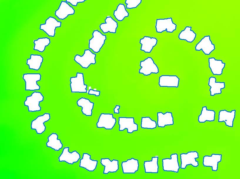
16 LiDAR Footprint Extraction 3 rd ALOS Joint PI Symposium, 9-13 Nov Keith W. Cunningham, PhD 15


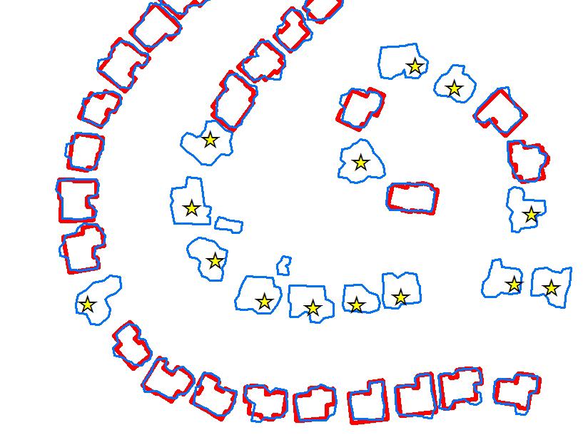
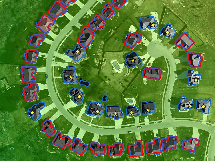
17 LiDAR & Planimetrics 3 rd ALOS Joint PI Symposium, 9-13 Nov Keith W. Cunningham, PhD 16

18 LiDAR vs. Heads-Up Digitizing Id Roof Lidar Diff % % % % % % % % % % % % na % % % % % % % % % % % % % % % % Average % rd ALOS Joint PI Symposium, 9-13 Nov Keith W. Cunningham, PhD 17
19 LiDAR Change Detection Create LiDAR structure Mask Compare Structure Footprint with Mask Automated Change Detection In a spreadsheet Map Algebra 3 rd ALOS Joint PI Symposium, 9-13 Nov Keith W. Cunningham, PhD 18

20 3 rd ALOS Joint PI Symposium, 9-13 Nov Keith W. Cunningham, PhD 19
21 LiDAR Ratio Analysis 1.8 meter postings Structure Masking Auto Change Detection using Ratio Analysis 3 rd ALOS Joint PI Symposium, 9-13 Nov Keith W. Cunningham, PhD 20

22 LiDAR Decision Tree New Feature: Pink & Yellow Missing Feature: Black No Change: White Possible Change: Gray Similar to a medical test with true positives & negatives and false positives & negatives 3 rd ALOS Joint PI Symposium, 9-13 Nov Keith W. Cunningham, PhD 21

23 Change Validation 3 rd ALOS Joint PI Symposium, 9-13 Nov Keith W. Cunningham, PhD 22


24 LiDAR & Relief Displacement Oblique Pictometry Bird s Eye 3 rd ALOS Joint PI Symposium, 9-13 Nov Keith W. Cunningham, PhD 23


25 Thank You Keith W. Cunningham, PhD Alaska Satellite Facility 3 rd ALOS Joint PI Symposium, 9-13 Nov Keith W. Cunningham, PhD 24
N.J.P.L.S. An Introduction to LiDAR Concepts and Applications
 N.J.P.L.S. An Introduction to LiDAR Concepts and Applications Presentation Outline LIDAR Data Capture Advantages of Lidar Technology Basics Intensity and Multiple Returns Lidar Accuracy Airborne Laser
Course Outline (1) #6 Data Acquisition for Built Environment. Fumio YAMAZAKI
 #6 Data Acquisition for Built Environment. Fumio YAMAZAKI") AT09.98 Applied GIS and Remote Sensing for Disaster Mitigation #6 Data Acquisition for Built Environment 9 October, 2002 Fumio YAMAZAKI yamazaki@ait.ac.th http://www.star.ait.ac.th/~yamazaki/ Course Outline
AT09.98 Applied GIS and Remote Sensing for Disaster Mitigation #6 Data Acquisition for Built Environment 9 October, 2002 Fumio YAMAZAKI yamazaki@ait.ac.th http://www.star.ait.ac.th/~yamazaki/ Course Outline
EXTRACTION OF URBAN PARAMETERS FROM 3D POINT-CLOUD WITHIN GRASS
 VII JORNADAS DE SIG LIBRE EXTRACTION OF URBAN PARAMETERS FROM 3D POINT-CLOUD WITHIN GRASS C.REBELO, A. M. RODRIGUES, B.NEVES, J.A. TENEDÓRIO, and J.A. GONÇALVES http://creativecommons.org/licenses/by-nc-sa/3.0/
Light Detection and Ranging (LiDAR)
") Light Detection and Ranging (LiDAR) http://code.google.com/creative/radiohead/ Types of aerial sensors passive active 1 Active sensors for mapping terrain Radar transmits microwaves in pulses determines
Light Detection and Ranging (LiDAR) http://code.google.com/creative/radiohead/ Types of aerial sensors passive active 1 Active sensors for mapping terrain Radar transmits microwaves in pulses determines
Automated Processing for 3D Mosaic Generation, a Change of Paradigm
 Automated Processing for 3D Mosaic Generation, a Change of Paradigm Frank BIGNONE, Japan Key Words: 3D Urban Model, Street Imagery, Oblique imagery, Mobile Mapping System, Parallel processing, Digital
Light Detection and Ranging (LiDAR) Radiohead House of Cards
 Radiohead House of Cards") Light Detection and Ranging (LiDAR) Radiohead House of Cards http://the-moni-blog.blogspot.com/2009/03/lidar-is-going-mainstream-mtv-baby.html h =? Laser Vision GPS + IMU θ H X a h Types of aerial sensors
Light Detection and Ranging (LiDAR) Radiohead House of Cards http://the-moni-blog.blogspot.com/2009/03/lidar-is-going-mainstream-mtv-baby.html h =? Laser Vision GPS + IMU θ H X a h Types of aerial sensors
Outline of Presentation. Introduction to Overwatch Geospatial Software Feature Analyst and LIDAR Analyst Software
 Outline of Presentation Automated Feature Extraction from Terrestrial and Airborne LIDAR Presented By: Stuart Blundell Overwatch Geospatial - VLS Ops Co-Author: David W. Opitz Overwatch Geospatial - VLS
Algorithms for GIS: Terrain simplification
 Algorithms for GIS: Terrain simplification Digital terrain models in GIS grid (raster) TIN Data Sources: digitizing contour maps Data Sources: satellite imagery Data Sources: satellite imagery \ Data Sources:
Trimble Geospatial Division Integrated Solutions for Geomatics professions. Volker Zirn Regional Sales Representative
 Trimble Geospatial Division Integrated Solutions for Geomatics professions Volker Zirn Regional Sales Representative 1 Agenda Trimble GeoSpatial Division Airborne System Solutions Trimble Inpho Software
Hamilton County Enhances GIS Base Mapping with 1-foot Contours
 Hamilton County Enhances GIS Base Mapping with 1-foot Contours Presented by Larry Stout, Hamilton County GIS Manager Brad Fugate, Woolpert Inc. Today s Presentation Hamilton County s 2004 Base Mapping
Mayden VP of Business Development Surdex Corporation
 Making Sense of Sensors Randy Mayden, Mayden VP of Business Development Surdex Corporation randym@surdex.com EARLYAERIAL PHOTOGRAPHY 2 FIRSTAERIAL CAMERA 3 AERIAL CAMERA SYSTEM DEVELOPMENT Aerial Camera
Digital Elevation Models
 Digital Elevation Models National Elevation Dataset 1 Data Sets US DEM series 7.5, 30, 1 o for conterminous US 7.5, 15 for Alaska US National Elevation Data (NED) GTOPO30 Global Land One-kilometer Base
LiDAR Remote Sensing Data Collection: Yaquina and Elk Creek Watershed, Leaf-On Acquisition
 LiDAR Remote Sensing Data Collection: Yaquina and Elk Creek Watershed, Leaf-On Acquisition Submitted by: 4605 NE Fremont, Suite 211 Portland, Oregon 97213 April, 2006 Table of Contents LIGHT DETECTION
Alaska Department of Transportation Roads to Resources Project LiDAR & Imagery Quality Assurance Report Juneau Access South Corridor
 Alaska Department of Transportation Roads to Resources Project LiDAR & Imagery Quality Assurance Report Juneau Access South Corridor Written by Rick Guritz Alaska Satellite Facility Nov. 24, 2015 Contents
Technical Considerations and Best Practices in Imagery and LiDAR Project Procurement
 Technical Considerations and Best Practices in Imagery and LiDAR Project Procurement Presented to the 2014 WV GIS Conference By Brad Arshat, CP, EIT Date: June 4, 2014 Project Accuracy A critical decision
About LIDAR Data. What Are LIDAR Data? How LIDAR Data Are Collected
 1 of 6 10/7/2006 3:24 PM Project Overview Data Description GIS Tutorials Applications Coastal County Maps Data Tools Data Sets & Metadata Other Links About this CD-ROM Partners About LIDAR Data What Are
Lecture 06. Raster and Vector Data Models. Part (1) Common Data Models. Raster. Vector. Points. Points. ( x,y ) Area. Area Line.
 Common Data Models. Raster. Vector. Points. Points. ( x,y ) Area. Area Line.") Lecture 06 Raster and Vector Data Models Part (1) 1 Common Data Models Vector Raster Y Points Points ( x,y ) Line Area Line Area 2 X 1 3 Raster uses a grid cell structure Vector is more like a drawn map
Lecture 06 Raster and Vector Data Models Part (1) 1 Common Data Models Vector Raster Y Points Points ( x,y ) Line Area Line Area 2 X 1 3 Raster uses a grid cell structure Vector is more like a drawn map
UAS to GIS Utilizing a low-cost Unmanned Aerial System (UAS) for Coastal Erosion Monitoring
 for Coastal Erosion Monitoring") UAS to GIS Utilizing a low-cost Unmanned Aerial System (UAS) for Coastal Erosion Monitoring A New Window on the World Personal Mapping for Micro-Geographies Accurate High Quality Simple Low-Cost Drone2Map
UAS to GIS Utilizing a low-cost Unmanned Aerial System (UAS) for Coastal Erosion Monitoring A New Window on the World Personal Mapping for Micro-Geographies Accurate High Quality Simple Low-Cost Drone2Map
Airborne Laser Survey Systems: Technology and Applications
 Abstract Airborne Laser Survey Systems: Technology and Applications Guangping HE Lambda Tech International, Inc. 2323B Blue Mound RD., Waukesha, WI-53186, USA Email: he@lambdatech.com As mapping products
Files Used in this Tutorial
 Generate Point Clouds and DSM Tutorial This tutorial shows how to generate point clouds and a digital surface model (DSM) from IKONOS satellite stereo imagery. You will view the resulting point clouds
FOOTPRINTS EXTRACTION
 Building Footprints Extraction of Dense Residential Areas from LiDAR data KyoHyouk Kim and Jie Shan Purdue University School of Civil Engineering 550 Stadium Mall Drive West Lafayette, IN 47907, USA {kim458,
BUILDING DETECTION AND STRUCTURE LINE EXTRACTION FROM AIRBORNE LIDAR DATA
 BUILDING DETECTION AND STRUCTURE LINE EXTRACTION FROM AIRBORNE LIDAR DATA C. K. Wang a,, P.H. Hsu a, * a Dept. of Geomatics, National Cheng Kung University, No.1, University Road, Tainan 701, Taiwan. China-
Processing of airborne laser scanning data
 GIS-E1020 From measurements to maps Lecture 8 Processing of airborne laser scanning data Petri Rönnholm Aalto University 1 Learning objectives To realize error sources of Airborne laser scanning To understand
ALS40 Airborne Laser Scanner
 ALS40 Airborne Laser Scanner Airborne LIDAR for Professionals High Performance Laser Scanning Direct Measurement of Ground Surface from the Air The ALS40 Airborne Laser Scanner measures the topography
Aerial and Mobile LiDAR Data Fusion
 Creating Value Delivering Solutions Aerial and Mobile LiDAR Data Fusion Dr. Srini Dharmapuri, CP, PMP What You Will Learn About LiDAR Fusion Mobile and Aerial LiDAR Technology Components & Parameters Project
Texturing Techniques in 3D City Modeling
 Texturing Techniques in 3D City Modeling 1 İdris Kahraman, 2 İsmail Rakıp Karaş, Faculty of Engineering, Department of Computer Engineering, Karabuk University, Turkey 1 idriskahraman@karabuk.edu.tr, 2
Automatic DTM Extraction from Dense Raw LIDAR Data in Urban Areas
 Automatic DTM Extraction from Dense Raw LIDAR Data in Urban Areas Nizar ABO AKEL, Ofer ZILBERSTEIN and Yerach DOYTSHER, Israel Key words: LIDAR, DSM, urban areas, DTM extraction. SUMMARY Although LIDAR
Mapping Project Report Table of Contents
 LiDAR Estimation of Forest Leaf Structure, Terrain, and Hydrophysiology Airborne Mapping Project Report Principal Investigator: Katherine Windfeldt University of Minnesota-Twin cities 115 Green Hall 1530
Terrestrial GPS setup Fundamentals of Airborne LiDAR Systems, Collection and Calibration. JAMIE YOUNG Senior Manager LiDAR Solutions
 Terrestrial GPS setup Fundamentals of Airborne LiDAR Systems, Collection and Calibration JAMIE YOUNG Senior Manager LiDAR Solutions Topics Terrestrial GPS reference Planning and Collection Considerations
CHAPTER 5 DIGITAL ELEVATION MODEL AND 3D VISUALIZATION
 CHAPTER 5 DIGITAL ELEVATION MODEL AND 3D VISUALIZATION A digital elevation model (DEM) is a digital model or 3D representation of a terrain's surface. A DEM can be represented as a raster (a grid of squares,
HAWAII KAUAI Survey Report. LIDAR System Description and Specifications
 HAWAII KAUAI Survey Report LIDAR System Description and Specifications This survey used an Optech GEMINI Airborne Laser Terrain Mapper (ALTM) serial number 06SEN195 mounted in a twin-engine Navajo Piper
Quality Accuracy Professionalism
 GeoWing - who are we? Mapping Data Service Provider Lidar Multispectral Topographic and Planimetric Maps Elevation Models Point Clouds / 3D Models Orthophotography FAA-Authorized UAS Operators WOSB / DBE
Bonemapping: A LiDAR Processing and Visualization Approach and Its Applications
 Bonemapping: A LiDAR Processing and Visualization Approach and Its Applications Thomas J. Pingel Northern Illinois University National Geography Awareness Week Lecture Department of Geology and Geography
Contents of Lecture. Surface (Terrain) Data Models. Terrain Surface Representation. Sampling in Surface Model DEM
 Data Models. Terrain Surface Representation. Sampling in Surface Model DEM") Lecture 13: Advanced Data Models: Terrain mapping and Analysis Contents of Lecture Surface Data Models DEM GRID Model TIN Model Visibility Analysis Geography 373 Spring, 2006 Changjoo Kim 11/29/2006 1
Lecture 13: Advanced Data Models: Terrain mapping and Analysis Contents of Lecture Surface Data Models DEM GRID Model TIN Model Visibility Analysis Geography 373 Spring, 2006 Changjoo Kim 11/29/2006 1
Airborne Laser Scanning: Remote Sensing with LiDAR
 Airborne Laser Scanning: Remote Sensing with LiDAR ALS / LIDAR OUTLINE Laser remote sensing background Basic components of an ALS/LIDAR system Two distinct families of ALS systems Waveform Discrete Return
An Introduction to Lidar & Forestry May 2013
 An Introduction to Lidar & Forestry May 2013 Introduction to Lidar & Forestry Lidar technology Derivatives from point clouds Applied to forestry Publish & Share Futures Lidar Light Detection And Ranging
Lecture 4: Digital Elevation Models
 Lecture 4: Digital Elevation Models GEOG413/613 Dr. Anthony Jjumba 1 Digital Terrain Modeling Terms: DEM, DTM, DTEM, DSM, DHM not synonyms. The concepts they illustrate are different Digital Terrain Modeling
Using ArcGIS Server Data to Assist in Planimetric Update Process. Jim Stout - IMAGIS Rick Hammond Woolpert
 Using ArcGIS Server Data to Assist in Planimetric Update Process Jim Stout - IMAGIS Rick Hammond Woolpert Using ArcGIS Server Data to Assist in Planimetric Update Process Jim Stout - IMAGIS Rick Hammond
Development of Methodology to Identify the Areas where Buildings are Broken down by Earthquake using Airborne Laser Technology
 Development of Methodology to Identify the Areas where Buildings are Broken down by Earthquake using Airborne Laser Technology by Hiromichi Maruyama 1, Masuo Taguchi 1, Masanori Sugiyama 1 and Yoshinori
Photogrammetry and 3D city modelling
 Digital Architecture and Construction 209 Photogrammetry and 3D city modelling Y. Kobayashi School of Architecture and Landscape Architecture, Arizona State University, USA Abstract 3D city modelling and
POSITIONING A PIXEL IN A COORDINATE SYSTEM
 GEOREFERENCING AND GEOCODING EARTH OBSERVATION IMAGES GABRIEL PARODI STUDY MATERIAL: PRINCIPLES OF REMOTE SENSING AN INTRODUCTORY TEXTBOOK CHAPTER 6 POSITIONING A PIXEL IN A COORDINATE SYSTEM The essential
ifp ifp Project Implementation Institut für Photogrammetrie virtualcitysystems, Dresden 3D Geo, Potsdam (now part of Autodesk) Starsoda, Berlin
 Starsoda, Berlin") Institut für Photogrammetrie The 3D Berlin Project Un niversit Martin Kada Institute for Photogrammetry y of Stut Project Implementation virtualcitysystems, Dresden Reconstruction ti of 3D building geometry
Institut für Photogrammetrie The 3D Berlin Project Un niversit Martin Kada Institute for Photogrammetry y of Stut Project Implementation virtualcitysystems, Dresden Reconstruction ti of 3D building geometry
Algorithms for GIS csci3225
 Algorithms for GIS csci3225 Laura Toma Bowdoin College LiDAR data in GIS LiDAR (Light Detection and Ranging) Each point records: its geographic location x,y its height z the number of returns in its pulse
AUTOMATIC GENERATION OF DIGITAL BUILDING MODELS FOR COMPLEX STRUCTURES FROM LIDAR DATA
 AUTOMATIC GENERATION OF DIGITAL BUILDING MODELS FOR COMPLEX STRUCTURES FROM LIDAR DATA Changjae Kim a, Ayman Habib a, *, Yu-Chuan Chang a a Geomatics Engineering, University of Calgary, Canada - habib@geomatics.ucalgary.ca,
UAV Flight Operations for Mapping. Precision. Accuracy. Reliability
 UAV Flight Operations for Mapping Precision. Accuracy. Reliability Part One: Why is Mapping different? Part Two: What about accuracy and precision? Part Three: What is the Workflow? Part Four: AGENDA What
Investigating the Structural Condition of Individual Trees using LiDAR Metrics
 Investigating the Structural Condition of Individual Trees using LiDAR Metrics Jon Murray 1, George Alan Blackburn 1, Duncan Whyatt 1, Christopher Edwards 2. 1 Lancaster Environment Centre, Lancaster University,
GeoEarthScope NoCAL San Andreas System LiDAR pre computed DEM tutorial
 GeoEarthScope NoCAL San Andreas System LiDAR pre computed DEM tutorial J Ramón Arrowsmith Chris Crosby School of Earth and Space Exploration Arizona State University ramon.arrowsmith@asu.edu http://lidar.asu.edu
Lecture 11. LiDAR, RADAR
 NRMT 2270, Photogrammetry/Remote Sensing Lecture 11 Calculating the Number of Photos and Flight Lines in a Photo Project LiDAR, RADAR Tomislav Sapic GIS Technologist Faculty of Natural Resources Management
LIDAR an Introduction and Overview
 LIDAR an Introduction and Overview Rooster Rock State Park & Crown Point. Oregon DOGAMI Lidar Project Presented by Keith Marcoe GEOG581, Fall 2007. Portland State University. Light Detection And Ranging
Remote Sensing Sensor Integration
 Remote Sensing Sensor Integration Erica Tharp LiDAR Supervisor Table of Contents About 3001 International Inc Remote Sensing Platforms Why Sensor Integration? Technical Aspects of Sensor Integration Limitations
Exercise 1: Introduction to LiDAR Point Cloud Data using the Fusion Software Package
 Exercise 1: Introduction to LiDAR Point Cloud Data using the Fusion Software Package Christopher Crosby, San Diego Supercomputer Center / OpenTopography (Adapted from tutorial by Ian Madin, DOGAMI) Last
Improving Flood Modelling and Visualisation using Remote Sensing
 Improving Flood Modelling and Visualisation using Remote Sensing David Mason 1, Paul Bates 2, Johanna Dall Amico 1, Matt Horritt 3, Jeff Neal 2, Guy Schumann 2, Rainer Speck 4. 1 Environmental Systems
Aalborg Universitet. Published in: Accuracy Publication date: Document Version Early version, also known as pre-print
 Aalborg Universitet A method for checking the planimetric accuracy of Digital Elevation Models derived by Airborne Laser Scanning Høhle, Joachim; Øster Pedersen, Christian Published in: Accuracy 2010 Publication
Cell Decomposition for Building Model Generation at Different Scales
 Cell Decomposition for Building Model Generation at Different Scales Norbert Haala, Susanne Becker, Martin Kada Institute for Photogrammetry Universität Stuttgart Germany forename.lastname@ifp.uni-stuttgart.de
IMPROVING 2D CHANGE DETECTION BY USING AVAILABLE 3D DATA
 IMPROVING 2D CHANGE DETECTION BY USING AVAILABLE 3D DATA C.J. van der Sande a, *, M. Zanoni b, B.G.H. Gorte a a Optical and Laser Remote Sensing, Department of Earth Observation and Space systems, Delft
A NEW APPROACH FOR GENERATING A MEASURABLE SEAMLESS STEREO MODEL BASED ON MOSAIC ORTHOIMAGE AND STEREOMATE
 A NEW APPROACH FOR GENERATING A MEASURABLE SEAMLESS STEREO MODEL BASED ON MOSAIC ORTHOIMAGE AND STEREOMATE Mi Wang State Key Laboratory of Information Engineering in Surveying Mapping and Remote Sensing
2010 LiDAR Project. GIS User Group Meeting June 30, 2010
 2010 LiDAR Project GIS User Group Meeting June 30, 2010 LiDAR = Light Detection and Ranging Technology that utilizes lasers to determine the distance to an object or surface Measures the time delay between
Geomatic & Information Technologies for Ports and Navigable Waterways. Expanding Our Global Opportunities
 Geomatic & Information Technologies for Ports and Navigable Waterways Airborne Remote Sensing Susan Jackson Tetra Tech Geomatics BD Director Hydrographic Surveying Robert Feldpausch Tetra Tech Principal
Third Rock from the Sun
 Geodesy 101 AHD LiDAR Best Practice The Mystery of LiDAR Best Practice Glenn Jones SSSi GIS in the Coastal Environment Batemans Bay November 9, 2010 Light Detection and Ranging (LiDAR) Basic principles
A DATA DRIVEN METHOD FOR FLAT ROOF BUILDING RECONSTRUCTION FROM LiDAR POINT CLOUDS
 A DATA DRIVEN METHOD FOR FLAT ROOF BUILDING RECONSTRUCTION FROM LiDAR POINT CLOUDS A. Mahphood, H. Arefi *, School of Surveying and Geospatial Engineering, College of Engineering, University of Tehran,
Digital Photogrammetric System. Version 6.3 USER MANUAL. LIDAR Data processing
 Digital Photogrammetric System Version 6.3 USER MANUAL Table of Contents 1. About... 3 2. Import of LIDAR data... 3 3. Load LIDAR data window... 4 4. LIDAR data loading and displaying... 6 5. Splitting
LiDAR data overview. Dr. Keiko Saito Global Facility for Disaster Reduction and Recovery (GFDRR)
") LiDAR data overview Dr. Keiko Saito Global Facility for Disaster Reduction and Recovery (GFDRR) LiDAR (Light Detecting And Ranging) 3D height profile Laser emitted from sensor onboard aircraft to measure
LiDAR data overview Dr. Keiko Saito Global Facility for Disaster Reduction and Recovery (GFDRR) LiDAR (Light Detecting And Ranging) 3D height profile Laser emitted from sensor onboard aircraft to measure
GSD-Elevation data, Grid 2+
 Date: Document version: 2016-12-01 2.3 Product description: GSD-Elevation data, Grid 2+ LANTMÄTERIET 2016-12-01 2 (12) List of contents 1 General description... 3 1.1 Contents... 3 1.2 Geographic coverage...
Small-footprint full-waveform airborne LiDAR for habitat assessment in the ChangeHabitats2 project
 Small-footprint full-waveform airborne LiDAR for habitat assessment in the ChangeHabitats2 project Werner Mücke, András Zlinszky, Sharif Hasan, Martin Pfennigbauer, Hermann Heilmeier and Norbert Pfeifer
iqmulus/terramobilita benchmark on Urban Analysis
 iqmulus/terramobilita benchmark on Urban Analysis Bruno Vallet, Mathieu Brédif, Béatriz Marcotegui, Andres Serna, Nicolas Paparoditis 1 / 50 Introduction 2 / 50 Introduction Mobile laser scanning (MLS)
Automatic Building Extrusion from a TIN model Using LiDAR and Ordnance Survey Landline Data
 Automatic Building Extrusion from a TIN model Using LiDAR and Ordnance Survey Landline Data Rebecca O.C. Tse, Maciej Dakowicz, Christopher Gold and Dave Kidner University of Glamorgan, Treforest, Mid Glamorgan,
MODULE 1 BASIC LIDAR TECHNIQUES
 MODULE SCENARIO One of the first tasks a geographic information systems (GIS) department using lidar data should perform is to check the quality of the data delivered by the data provider. The department
The use of different data sets in 3-D modelling
 The use of different data sets in 3-D modelling Ahmed M. HAMRUNI June, 2014 Presentation outlines Introduction Aims and objectives Test site and data Technology: Pictometry and UltraCamD Results and analysis
GENERATING BUILDING OUTLINES FROM TERRESTRIAL LASER SCANNING
 GENERATING BUILDING OUTLINES FROM TERRESTRIAL LASER SCANNING Shi Pu International Institute for Geo-information Science and Earth Observation (ITC), Hengelosestraat 99, P.O. Box 6, 7500 AA Enschede, The
Documentation for the analysis of the ground-based Alvord Basin LiDAR dataset
 Documentation for the analysis of the ground-based Alvord Basin LiDAR dataset Introduction David E. Haddad david.e.haddad@asu.edu July 2008 This report presents the procedures carried out, the results
3D CITY MODELLING WITH CYBERCITY-MODELER
 1 3D CITY MODELLING WITH CYBERCITY-MODELER Kilian Ulm 1 and Daniela Poli 1 1. CyberCity AG, Zurich, Switzerland, (kilian.ulm, daniela.poli)@cybercity.tv ABSTRACT 3D city models using stereo aerial-/satellite
Image Services for Elevation Data
 Image Services for Elevation Data Peter Becker Need for Elevation Using Image Services for Elevation Data sources Creating Elevation Service Requirement: GIS and Imagery, Integrated and Accessible Field
LIDAR Quality Levels Part 1
 Lewis Graham, CTO GeoCue Group The LIDAR community has been gradually adopting the terminology Quality Level to categorize airborne LIDAR data. The idea is to use a simple scheme to characterize the more
Todd King, PLS, LEED AP Business Developer
 Todd King, PLS, LEED AP Business Developer TKing@McKimCreed.com 38 YEARS 378 EMPLOYEES ENR Top 500 Design Firm ENR Top 200 Environmental ENR Southeast Engineer Firms POB Geospatial Top 100 Top 50 Trenchless
INTEGRATION OF LIDAR DATA INTO A MUNICIPAL GIS TO STUDY SOLAR RADIATION
 International Archives of the Photogrammetry, Remote Sensing and Spatial Information Sciences, INTEGRATION OF LIDAR DATA INTO A MUNICIPAL GIS TO STUDY SOLAR RADIATION P. Africanib, G. Bitellia, A. Lambertinia,,
UTILIZACIÓN DE DATOS LIDAR Y SU INTEGRACIÓN CON SISTEMAS DE INFORMACIÓN GEOGRÁFICA
 UTILIZACIÓN DE DATOS LIDAR Y SU INTEGRACIÓN CON SISTEMAS DE INFORMACIÓN GEOGRÁFICA Aurelio Castro Cesar Piovanetti Geographic Mapping Technologies Corp. (GMT) Consultores en GIS info@gmtgis.com Geographic
Digital photogrammetry project with very high-resolution stereo pairs acquired by DigitalGlobe, Inc. satellite Worldview-2
 White PAPER Greater area of the City of La Paz, Bolivia Digital photogrammetry project with very high-resolution stereo pairs acquired by DigitalGlobe, Inc. satellite Worldview-2 By: Engineers Nelson Mattie,
ENY-C2005 Geoinformation in Environmental Modeling Lecture 4b: Laser scanning
 1 ENY-C2005 Geoinformation in Environmental Modeling Lecture 4b: Laser scanning Petri Rönnholm Aalto University 2 Learning objectives To recognize applications of laser scanning To understand principles
High resolution survey and orthophoto project of the Dosso-Gaya region in the Republic of Niger. by Tim Leary, Woolpert Inc.
 High resolution survey and orthophoto project of the Dosso-Gaya region in the Republic of Niger by Tim Leary, Woolpert Inc. Geospatial Solutions Photogrammetry & Remote Sensing LiDAR Professional Surveying
3D LIDAR Point Cloud based Intersection Recognition for Autonomous Driving
 3D LIDAR Point Cloud based Intersection Recognition for Autonomous Driving Quanwen Zhu, Long Chen, Qingquan Li, Ming Li, Andreas Nüchter and Jian Wang Abstract Finding road intersections in advance is
Terrain Modeling and Mapping for Telecom Network Installation Using Scanning Technology. Maziana Muhamad
 Terrain Modeling and Mapping for Telecom Network Installation Using Scanning Technology Maziana Muhamad Summarising LiDAR (Airborne Laser Scanning) LiDAR is a reliable survey technique, capable of: acquiring
LIDAR and Terrain Models: In 3D!
 LIDAR and Terrain Models: In 3D! Stuart.green@teagasc.ie http://www.esri.com/library/whitepapers/pdfs/lidar-analysis-forestry.pdf http://www.csc.noaa.gov/digitalcoast/_/pdf/refinement_of_topographic_lidar_to_create_a_bare_e
THE ISPRS/EUROSDR BENCHMARK ON MULTI-PLATFORM PHOTOGRAMMETRY: RESULTS AND LESSON LEARNT FRANCESCO NEX AND MARKUS GERKE
 THE ISPRS/EUROSDR BENCHMARK ON MULTI-PLATFORM PHOTOGRAMMETRY: RESULTS AND LESSON LEARNT FRANCESCO NEX AND MARKUS GERKE Overview Summary of the results Statistics Data release What s next? ISPRS / EuroSDR
MODELLING FOREST CANOPY USING AIRBORNE LIDAR DATA
 MODELLING FOREST CANOPY USING AIRBORNE LIDAR DATA Jihn-Fa JAN (Taiwan) Associate Professor, Department of Land Economics National Chengchi University 64, Sec. 2, Chih-Nan Road, Taipei 116, Taiwan Telephone:
AUTOMATIC BUILDING RECONSTRUCTION FROM VERY HIGH RESOLUTION AERIAL STEREOPAIRS USING CADASTRAL GROUND PLANS
 AUTOMATIC BUILDING RECONSTRUCTION FROM VERY HIGH RESOLUTION AERIAL STEREOPAIRS USING CADASTRAL GROUND PLANS Hassan JIBRINI * Nicolas PAPARODITIS *** Marc Pierrot DESEILLIGNY *** Henri MAITRE **** * MATIS/IGN
Lecture 21 - Chapter 8 (Raster Analysis, part2)
") GEOL 452/552 - GIS for Geoscientists I Lecture 21 - Chapter 8 (Raster Analysis, part2) Today: Digital Elevation Models (DEMs), Topographic functions (surface analysis): slope, aspect hillshade, viewshed,
GEOL 452/552 - GIS for Geoscientists I Lecture 21 - Chapter 8 (Raster Analysis, part2) Today: Digital Elevation Models (DEMs), Topographic functions (surface analysis): slope, aspect hillshade, viewshed,
TRIMBLE BUSINESS CENTER PHOTOGRAMMETRY MODULE
 TRIMBLE BUSINESS CENTER PHOTOGRAMMETRY MODULE WHITE PAPER TRIMBLE GEOSPATIAL DIVISION WESTMINSTER, COLORADO, USA July 2013 ABSTRACT The newly released Trimble Business Center Photogrammetry Module is compatible
Merging LiDAR Data with Softcopy Photogrammetry Data
 Merging LiDAR Data with Softcopy Photogrammetry Data Cindy McCallum WisDOT\Bureau of Technical Services Surveying & Mapping Section Photogrammetry Unit Overview Terms and processes Why use data from LiDAR
Drone2Map for ArcGIS: Bring Drone Imagery into ArcGIS. Will
 Drone2Map for ArcGIS: Bring Drone Imagery into ArcGIS Will Meyers @MeyersMaps A New Window on the World Personal Mapping for Micro-Geographies Accurate High Quality Simple Low-Cost Drone2Map for ArcGIS
Validation of Aerial LiDAR Products For Transportation Applications
 Creating Value Delivering Solutions Validation of Aerial LiDAR Products For Transportation Applications Dr. Srini Dharmapuri, CP, PMP Michael Baker Jr., Inc. Lauren Little, PE Alaska DOT Public Facility
DIGITAL SURFACE MODELS OF CITY AREAS BY VERY HIGH RESOLUTION SPACE IMAGERY
 DIGITAL SURFACE MODELS OF CITY AREAS BY VERY HIGH RESOLUTION SPACE IMAGERY Jacobsen, K. University of Hannover, Institute of Photogrammetry and Geoinformation, Nienburger Str.1, D30167 Hannover phone +49
Phone: Fax: Table of Contents
 Geomorphic Characterization of Precarious Rock Zones LIDAR Mapping Project Report Principal Investigator: David E. Haddad Arizona State University ASU School of Earth and Space
Using LiDAR (Light Distancing And Ranging) data to more accurately describe avalanche terrain
 data to more accurately describe avalanche terrain") International Snow Science Workshop, Davos 009, Proceedings Using LiDAR (Light Distancing And Ranging) data to more accurately describe avalanche terrain Christopher M. McCollister, and Robert H. Comey,
International Snow Science Workshop, Davos 009, Proceedings Using LiDAR (Light Distancing And Ranging) data to more accurately describe avalanche terrain Christopher M. McCollister, and Robert H. Comey,
I. Project Title Light Detection and Ranging (LIDAR) Processing
 Processing") I. Project Title Light Detection and Ranging (LIDAR) Processing II. Lead Investigator Ryan P. Lanclos Research Specialist 107 Stewart Hall Department of Geography University of Missouri Columbia Columbia,
I. Project Title Light Detection and Ranging (LIDAR) Processing II. Lead Investigator Ryan P. Lanclos Research Specialist 107 Stewart Hall Department of Geography University of Missouri Columbia Columbia,
National Science Foundation Engineering Research Center. Bingcai Zhang BAE Systems San Diego, CA
 Bingcai Zhang BAE Systems San Diego, CA 92127 Bingcai.zhang@BAESystems.com Introduction It is a trivial task for a five-year-old child to recognize and name an object such as a car, house or building.
Chapters 1 7: Overview
 Chapters 1 7: Overview Photogrammetric mapping: introduction, applications, and tools GNSS/INS-assisted photogrammetric and LiDAR mapping LiDAR mapping: principles, applications, mathematical model, and
Objectives Learn how GMS uses rasters to support all kinds of digital elevation models and how rasters can be used for interpolation in GMS.
 v. 9.1 GMS 9.1 Tutorial Using rasters for interpolation and visualization in GMS Objectives Learn how GMS uses rasters to support all kinds of digital elevation models and how rasters can be used for interpolation
Experiments on Generation of 3D Virtual Geographic Environment Based on Laser Scanning Technique
 Experiments on Generation of 3D Virtual Geographic Environment Based on Laser Scanning Technique Jie Du 1, Fumio Yamazaki 2 Xiaoyong Chen 3 Apisit Eiumnoh 4, Michiro Kusanagi 3, R.P. Shrestha 4 1 School
LiDAR Technical Report NE Washington LiDAR Production 2017
 LiDAR Technical Report NE Washington LiDAR Production 2017 Presented to: Washington DNR 1111 Washington Street SE Olympia, Washington 98504 Submitted by: 860 McKinley St Eugene, OR 97402 July 26, 2017
Phone: (603) Fax: (603) Table of Contents
 Fax: (603) Table of Contents") Hydrologic and topographic controls on the distribution of organic carbon in forest Soils LIDAR Mapping Project Report Principal Investigator: Adam Finkelman Plumouth State University Plymouth State University,
Hydrologic and topographic controls on the distribution of organic carbon in forest Soils LIDAR Mapping Project Report Principal Investigator: Adam Finkelman Plumouth State University Plymouth State University,