Network Analyst: Performing Network Analysis
|
|
|
- Andrea Singleton
- 6 years ago
- Views:
Transcription


1 Esri International User Conference San Diego, California Technical Workshops July 24, 2012 Network Analyst: Performing Network Analysis Jay Sandhu Deelesh Mandloi
2 Goals We assume you have some familiarity with ArcGIS Network Analyst We describe the capabilities of the solvers and will demonstrate them with several practical examples Areas of focus are: - Choosing the right solver - Configuring solvers for effective results


3 Route Closest Facility Service Area ArcGIS Network Analyst Extension Solving transportation problems Location-Allocation Vehicle Routing Problem Origin-Destination Cost Matrix


4 Where do you get street data? Included with ArcGIS - Data and Maps media - North America ready-to-route dataset Vendor data Vendor street data processing tools Government data - TIGER Community data - OpenStreetMap - OSM to NDS tools Your own data No street data at all - Network analysis services on ArcGIS online


5 Network Analyst Workflow First: Add Street Data Second: Create a Route Layer

6 Network Analyst Creating a Route NA Layer New Route Layer in the NA Window

7 Network Analyst Setting Analysis Properties Route Layer Properties: Set Impedance Attribute


8 Network Analyst Load Locations Add more fields such as ID s to NA sub-layers and map them here Map fields to load additional attributes

9 Network Analyst Solving a Route Solve

10 Network Analyst Analyze the results ¼ Mile Buffer
11 Common Workflow With Load Locations Use Calculate Location tool to pre-compute network locations for faster load of locations - Can also exclude locating on restricted elements - Use SQL Where clause for more control on where to locate locations such as avoid freeway ramps Use the 1 key to see where a point is located on a network. Use the 2 key for reverse geo-coding
12 Network Analyst solver settings Barriers scaled or restricted - Point, line and polygon Restrictions - One-way, height, weight, left-turn, etc Accumulations - Pick a list of attributes to accumulate and report Output Shape type - Measures enables linear referencing Hierarchy - For fast performance with very long routes (nationwide)
13 Network Analyst Traversal results Route, Closest Facility and Service Area keep the traversal results in memory Use the new GP tool Copy Traversed Source Feature to access them and turn them into feature class for later analysis - Before 10.1, use an ArcGIS AddIn on our resource web site Very detailed and useful for summary applications
14 Route Closest Facility Service Area ArcGIS Network Analyst Extension Solving transportation problems Location-Allocation Vehicle Routing Problem Origin-Destination Cost Matrix

15 Route Find Shortest Paths For a set of locations For many groups of locations or Multi-Route - Or between pairs of Origin and Destination locations Multi-Route
16 Route Options Minimize any network attribute like travel time and distance Honor navigation necessities such as - Curb approach - U-turn rules - Turn delays - Street restrictions - Height - Weight - One-way - Time of day by using historical as well as real-time traffic information


17 Route Optimal Shortest Paths Also called the Travelling Salesperson Problem - Use when you have a single vehicle or person that needs to visit a set of discrete locations in the shortest sequence

18 Route Demo Mileage summary by State
19 Route Closest Facility Service Area ArcGIS Network Analyst Extension Solving transportation problems Location-Allocation Vehicle Routing Problem Origin-Destination Cost Matrix

20 Closest Facility Typical Applications Find closest application - Closest ATM or Store locator - Emergency roadside assistance dispatch Closest Hospital From Incident
21 Closest Facility Use CF when shape, directions or traversal results are needed - Else, use OD Cost Matrix solver for computing costs Tips on effective use: - Use hierarchy only for large distances (~30 miles) - Set a reasonable cutoff - Pre-process the facilities and load only those that are near the incidents For large number of facilities, use 64 bit OS with 4 GB - Or use chunking, enabled via registry keys/details in online KB article

22 Closest Facility Demo Most traversed streets
23 Route Closest Facility Service Area ArcGIS Network Analyst Extension Solving transportation problems Location-Allocation Vehicle Routing Problem Origin-Destination Cost Matrix

24 Service Area What areas are within 30 minutes of a location - Retail/demographic analysis sum up demand within a 5 minute drive time of a potential store location


25 Service Area Detailed Option Has Holes Generalized Option

26 Service Area To avoid holes: - Use Generalized option - When using a multi-modal network dataset, use Exclude Sources option Generalized Option Use Appropriate Trim Distance Exclude Metro sources

27 Service Areas Service Areas now support the Hierarchy option - Scalable - Fast Hierarchy Option
28 Service Area Uses Use Lines options to check the connectivity in the network Makes very appealing visuals on a map For large number of facilities, use one of these options - Hierarchy - 64 bit OS with 4 GB - Enable chunking via registry keys/details on online KB article


29 Service Area Demo Demographic summary Ad Placement
30 Route Closest Facility Service Area ArcGIS Network Analyst Extension Solving transportation problems Location-Allocation Vehicle Routing Problem Origin-Destination Cost Matrix

31 Origin-Destination Cost Matrix Solver Computes network distances between sets of locations
32 Origin-Destination Cost Matrix Solver Internally used by - Reorder Stops to Find Optimal Route option - Vehicle Routing Problem - Location-Allocation - Generate Network Spatial Weights tool in the Spatial Statistics toolbox Can use with external processes like custom VRP or Linear Programming for advanced analysis - Deelesh s Allocation Tools on Resource Center
33 Origin-Destination Cost Matrix Tips on effective use: - Use hierarchy only for large distances (~30 miles) - Set a reasonable cutoff - Do not solve as the active analysis layer (use GP) - Use ArcObjects for very large OD with no output lines - Use 64 bit OS which allows ArcGIS 10 and 10.1 to use 4 GB of RAM

34 OD Cost Matrix Demo Accumulate Attributes School Allocation
35 Route Closest Facility Service Area ArcGIS Network Analyst Extension Solving transportation problems Location-Allocation Vehicle Routing Problem Origin-Destination Cost Matrix


36 Vehicle Routing Problem This is not the simple Travelling Salesperson Problem! Multiple Vehicles with different capacities
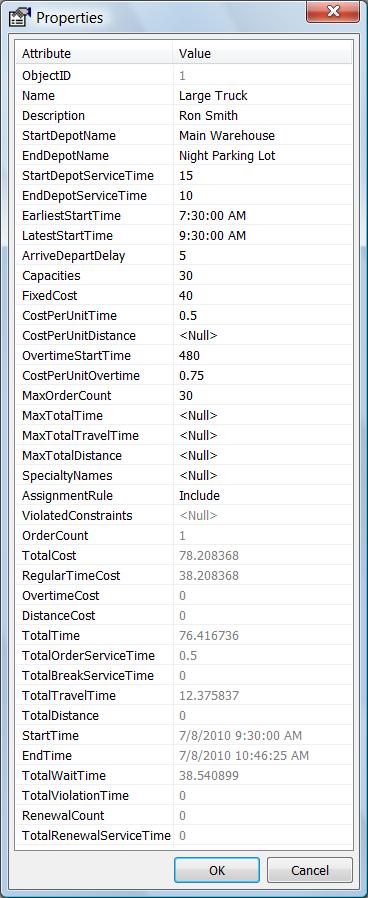
37 Vehicle Routing Problem.vs. TSP Use VRP solver when you have - A fleet of vehicles with defined capacities - One or more warehouse or dispatch locations - Customers have delivery time preferences Additional capabilities - Drivers can take multiple-breaks - Routes can be generated around seed points, e.g. driver home - Drivers with technical specialty can be matched to service order


38 Vehicle Routing Problem Capabilities Order Properties Warehouse Properties Route/Driver Properties
39 Vehicle Routing Problem Capabilities For more information, see the online help! VRP Online Help
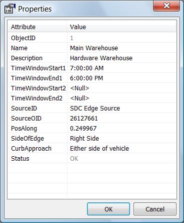
40 Vehicle Routing Problem Uses Service problem: - Send technicians to service clients on-site, i.e. pest control Delivery problem: - Deliver packages from the warehouse to clients, i.e. hardware deliveries Paired-order service problem: - Pick up people from one location and deliver them to another location, i.e. bus tour problem Paired-order delivery problem: - Deliver packages from one location to another, i.e. package deliveries

41 VRP Demo Flag Fundraiser
42 Route Closest Facility Service Area ArcGIS Network Analyst Extension Solving transportation problems Location-Allocation Vehicle Routing Problem Origin-Destination Cost Matrix
43 Location-Allocation Useful for locating - Warehouses - Retail Stores - Fire Stations At 10.1, Facilities can have capacity - School allocation

44 Location-Allocation Optimize warehouse location for VRP Re-locating Warehouse Saves five percent fuel
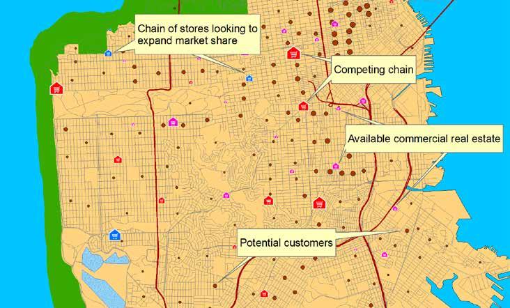
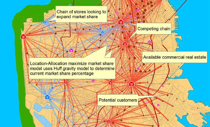
45 Location-Allocation Gravity Models! Location-Allocation supports the gravity model (also called the Huff model) for competitive locations. Inputs: - Your locations - Your competitor locations - Demand locations - Distance decay parameters - Market share - Locates sites to maximize market share - Target market share Computes number of sites needed to achieve a target market share (say 24%) If all inputs are fixed then you can use Location- Allocation to compute spatial-interactions!
46 Location-Allocation Gravity Models example
47 Location-Allocation Estimating Beta Tobler s First Law of Geography: - Everything is related to everything else, but near things are more related than distant things Also called distance decay Start with a survey of distance travelled by customers to come to a typical location Make a table of cumulative trips Make an inverse and create an XY scatter plot Fit an appropriate trend line
48 Location-Allocation Beta trend line in Excel
49 Location-Allocation Tips on effective usage: - Use an appropriate distance cutoff - Each demand point can have it s own cutoff - Urban.vs. Rural populations - Pick suitable candidates - If large number of demand/candidate points then aggregate Use LA to generate many alternatives and feeding into a Decision Support System

50 Location-Allocation Demo Maximize Coverage
51 Things to watch out for Do not include your start/end locations as junctions in the network dataset - This causes your locations to snap on to these junctions which are usually not connected to any edges and no paths are found. Travel times are computed at posted speed limits and are too optimistic - Use new historic traffic information - Use global turn delays De-compose problems regionally if performance is an issue
52 Summary Pick the right solver for the task Choose appropriate analysis settings To learn more - Go through the NA Tutorials - Lot of help available on-line - Visit the ArcGIS resource centers for useful utilities and data
53 What s new at 10.1 Faster service area Capacitated location-allocation Enhanced restrictions - avoid or prefer certain roads All solvers are time aware Real-time traffic Geoprocessing improvements - arcpy.na site package - Copy traversal result tool - Simpler publishing story (SA and VRP) Public services
54 Network Analyst at the User s Conference
55 Tech Workshops Network Analyst An Introduction Network Analyst Performing Network Analysis Network Analyst Automating Workflows with Geoprocessing Network Analyst Creating Network Datasets Network Analysis with ArcGIS for Server
56 Demo Theaters What s new in Network Analyst at 10.1? Routing with Open Source Data (OSM) Modeling Real-World Problems with the VRP Solver Routing Inside Buildings with 3D Networks Using Streetmap Premium
 *** Network Analyst: Creating Network Datasets Room 9 Network Analyst: Performing Network Analysis Room 4")
57 8:30 9 am Network Analyst: An Introduction Room 3 Tuesday Wednesday Thursday Modeling Real-World Problems with the VRP Solver ** Network Analyst: Automating workflows with Geoprocessing Room am 11 am Network Analyst: Performing Network Analysis Room 3 Routing with Open Source Data (OSM) *** Network Analyst: Creating Network Datasets Room 9 Network Analyst: Performing Network Analysis Room 4 Routing in buildings with 3D Networks ** 12 pm 1 pm Routing with Open Source Data (OSM) *** 2 pm Network Analysis with ArcGIS for Server Room 3 Network Analyst: An Introduction Room 4 Using Streetmap Premium * Network Analyst: Creating Network Datasets Room 9 3 pm 4 pm 5 pm What s New in Network Analyst 10.1 ** Locations * Demo Theater Online GIS Exhibit Hall C ** Demo Theater Analysis and Geoprocessing Exhibit Hall B2 *** Demo Theater Esri Labs Exhibit Hall B1

58 Tuesday Wednesday 8 am 9 am Geocoding: An Introduction Room 14A Using Streetmap Premium * 10 am 11 am Geocoding: Advanced Techniques Room 14A What s new at 10.1 in Geocoding ** Locations * Demo Theater Onilne GIS Exhibit Hall C ** Demo Theater Analysis and Geoprocessing - Exhibit Hall B 12 pm 1 pm 2 pm From a table of addresses to locations on the map the Geocoding workflow ** Geocoding: An Introduction Room 14A Using Streetmap Premium * 3 pm 4 pm Geocoding: Advanced Techniques Room 14A


59 Moderated Paper Sessions Use of Network Analyst for Web-Based Bicycle Trip- Planning Applications - Wednesday 1:30 2:45 Room 27B (Second presentation) ArcGIS Network Analyst Identifies Emergency and Evacuation Safe Routes - Wednesday 3:15 4:30 Room 17B (First presentation)


60 Steps to evaluate UC sessions My UC Homepage > Evaluate Sessions Choose session from planner OR Search for session by offering ID: 587
61 Thank you for attending Have fun at UC2012 Open for Questions Please fill out the evaluation: First Offering ID: 587 (Tuesday) Second Offering ID: 1168 (Wednesday)
Network Analyst: An Introduction
 2013 Esri International User Conference July 8 12, 2013 San Diego, California Technical Workshop Network Analyst: An Introduction Patrick Stevens Robert Garrity Esri UC2013. Technical Workshop. Introduction
Network Analysis with ArcGIS Online and On-premise Services
 2013 Esri International User Conference July 8 12, 2013 San Diego, California Technical Workshop Network Analysis with ArcGIS Online and On-premise Services Deelesh Mandloi Dmitry Kudinov Esri UC2013.
Open File Explorer Start Pro with SanFran project Open Locator in SanFran project Open Browser and AGOL with RouteExample Web map.
 Open File Explorer Start Pro with SanFran project Open Locator in SanFran project Open Browser and AGOL with RouteExample Web map. Open Browser with this: http://nadev.arcgis.com/arcgis/samples/easyvrp/easyvrp.html
Networks in GIS. Geometric Network. Network Dataset. Utilities and rivers One-way flow. Traffic data 2-way flow Multi-modal data
 Unit 6: Networks Networks in GIS Model the flow of resources Consist of a set of connected centers or junctions (ArcGIS) displayed as points. Junctions are connected by links, or edges (ArcGIS) displayed
Network Analyst Creating Network Datasets. Jay Sandhu Frank Kish
 Network Analyst Creating Network Datasets Jay Sandhu Frank Kish Agenda Preparing Street Data for use in a network dataset - One-way streets - Hierarchy - RoadClass attribute Using turns, signposts, and
Network Analyst Creating Network Datasets
 2013 Esri International User Conference July 8 12, 2013 San Diego, California Technical Workshop Network Analyst Creating Network Datasets Colin Childs Alan Hatakeyama Esri UC2013. Technical Workshop.
What is Network Analyst?
 What is Network Analyst? Extension for analyzing transportation networks Four network solvers Route Closest Facility Service Area Uses Network Datasets Origin-Destination (OD) Cost Matrix Specialized layers
ArcGIS Network Analyst and Network Dataset. Jim McKinney ESRI
 ArcGIS Network Analyst and Network Dataset Jim McKinney ESRI ArcGIS Network Analyst Everything in ArcView GIS 3x and more Routing Directions Network Analysis Tight Integration with Geoprocessing Models
Network Analyst Creating Network Datasets. Colin Childs Alan Hatakeyama
 Network Analyst Creating Network Datasets Colin Childs Alan Hatakeyama Agenda Preparing street data for use in a network dataset - Oneway streets - Hierarchy - RoadClass attribute Using turns, signposts,
Designing and Using Cached Map Services
 Esri International User Conference San Diego, California Technical Workshops July 2012 Designing and Using Cached Map Services Sterling Quinn Eric Rodenberg What we will cover Session Topics - Map cache
Esri International User Conference. San Diego, California. Technical Workshops. July Creating Surfaces. Steve Kopp and Steve Lynch
 Esri International User Conference San Diego, California Technical Workshops July 2011 Creating Surfaces Steve Kopp and Steve Lynch Overview Learn the types of surfaces and the data structures used to
ArcGIS Online: Developing Web Applications with Routing Services. Deelesh Mandloi Dmitry Kudinov
 ArcGIS Online: Developing Web Applications with Routing Services Deelesh Mandloi Dmitry Kudinov Metadata Slides available at http://esriurl.com/ds17drs Documentation at http://developers.arcgis.com/features/directions
ArcGIS Online: Using the Python API for Transportation Network Analysis. Deelesh Mandloi and Dmitry Kudinov
 ArcGIS Online: Using the Python API for Transportation Network Analysis Deelesh Mandloi and Dmitry Kudinov Metadata Slides and code samples available at http://esriurl.com/ds18napy Documentation at http://developers.arcgis.com/features/directions
Network Analyst: Creating Network Datasets. Patrick Stevens Alan Hatakeyama
 Network Analyst: Creating Network Datasets Patrick Stevens Alan Hatakeyama Agenda Do you need to create a network dataset? Preparing street data for use in a network dataset Using turns, signposts, and
Copyright The McGraw-Hill Companies, Inc. Permission required for reproduction or display.
 Chapter 17. PATH ANALYSIS AND NETWORK APPLICATIONS 17.1 Path Analysis 17.1.1 Source Raster 17.1.2 Cost Raster Box 17.1 Cost Raster for a Site Analysis of Pipelines 17.1.3 Cost Distance Measures 17.1.4
ArcMap: Tips and Tricks
 Esri International User Conference San Diego, California Technical Workshops July 23 27, 2012 ArcMap: Tips and Tricks Miriam Schmidts Jorge Ruiz-Valdepena Agenda Navigating ArcMap Repairing data links
Esri Maps for SharePoint
 Esri International User Conference San Diego, California Technical Workshops July, 2012 Esri Maps for SharePoint Art Haddad Nathan Bennett Agenda Location Analytics - Esri Maps for SharePoint - Overview
ArcGIS Online: Developing Web Applications with Geocoding and Routing Services. Deelesh Mandloi Dmitry Kudinov Brad Niemand
 ArcGIS Online: Developing Web Applications with Geocoding and Routing Services Deelesh Mandloi Dmitry Kudinov Brad Niemand Metadata Slides available at http://esriurl.com/ds15gr Slides and video recording
Deelesh Mandloi, Jay Sandhu, Tarun Chandrasekhar
 ArcGIS 9 ArcGIS Network Analyst Tutorial G08807_U-AGIS-3DA_tp_94692.ind 1 3/11/04, 10:24 AM Copyright 2008 ESRI All rights reserved. Printed in the United States of America. The information contained in
Developing Web Applications with Geocoding and Routing Services Using ArcGIS Online. Deelesh Mandloi Dmitry Kudinov Brad Niemand
 Developing Web Applications with Geocoding and Routing Services Using ArcGIS Online Deelesh Mandloi Dmitry Kudinov Brad Niemand Metadata Slides will be available at http://proceedings.esri.com Documentation
Georeferencing. Georeferencing: = linking a layer or dataset with spatial coordinates. Registration: = lining up layers with each other
 Georeferencing How do we make sure all our data layers line up? Georeferencing: = linking a layer or dataset with spatial coordinates Registration: = lining up layers with each other Rectification: The
An Introduction to Data Interoperability
 Esri International User Conference San Diego, California 2012 Technical Workshops July 24/25 An Introduction to Data Interoperability Bruce Harold - Esri Dale Lutz Safe Software Background Why Data Interoperability?
Building Applications with the ArcGIS Runtime SDK for WPF
 Esri International User Conference San Diego, California Technical Workshops 24 th July 2012 Building Applications with the ArcGIS Runtime SDK for WPF Euan Cameron & Paul Pilkington Agenda Introduction
ArcMap Tips and Tricks
 2013 Esri International User Conference July 8 12, 2013 San Diego, California Technical Workshop ArcMap Tips and Tricks Jack Horton Jorge Ruiz-Valdepeña Esri UC2013. Technical Workshop. Jorge s Agenda
Developing Qt Apps with the Runtime SDK
 Developing Qt Apps with the Runtime SDK Thomas Dunn and Michael Tims Esri UC 2014 Technical Workshop Agenda Getting Started Creating the Map Geocoding and Routing Geoprocessing Message Processing Work
Navigator for ArcGIS Presented by
 Navigator for ArcGIS Presented by Navigator for ArcGIS Get your field workforce where it needs to be Custom data (search, route, display) Fully integrated with other apps Advanced vehicle travel modes
Navigator for ArcGIS an Introduction
 Esri Developer Summit March 8 11, 2016 Palm Springs, CA Navigator for ArcGIS an Introduction Scott Sandusky Navigator for ArcGIS Navigator for ArcGIS is a mobile app that gets your field workforce where
Finding Your Way with ArcGIS Network Analyst. Frederic Schettini Michael Rice
 Finding Your Way with ArcGIS Network Analyst Frederic Schettini Michael Rice Agenda Introduction to Network Analyst Working with ArcGIS Engine Working with ArcGIS Server Support & Resources Questions ArcGIS
Geospatial Day II Introduction to ArcGIS Editor for Open Street Map
 Geospatial Day II Introduction to ArcGIS Editor for Open Street Map Geospatial Operations Support Team (GOST) Katie McWilliams kmcwilliams@worldbankgroup.org GOST@worldbank.org 0 Using OSM for Network
Python - Raster Analysis
 Esri International User Conference San Diego, California Technical Workshops July 2012 Python - Raster Analysis Kevin M. Johnston Ryan DeBruyn The problem that is being addressed You have a complex modeling
Spatial Analysis (Vector) II
 II") Spatial Analysis (Vector) II GEOG 300, Lecture 9 Dr. Anthony Jjumba 1 A Spatial Network is a set of geographic locations interconnected in a system by a number of routes is a system of linear features
Spatial Analysis (Vector) II GEOG 300, Lecture 9 Dr. Anthony Jjumba 1 A Spatial Network is a set of geographic locations interconnected in a system by a number of routes is a system of linear features
The names of other companies and products herein are trademarks or registered trademarks of their respective trademark owners.
 ArcGIS 9 ArcGIS Network Analyst Tutorial G08807_U-AGIS-3DA_tp_94692.ind 1 3/11/04, 10:24 AM Copyright 2005 ESRI. All rights reserved. Printed in the United States of America. The information contained
Topology in the Geodatabase an Introduction. Erik Hoel Doug Morgenthaler
 Topology in the Geodatabase an Introduction Erik Hoel Doug Morgenthaler ESRI Super Secret Topology Laboratory, May 2012 Agenda ArcGIS Topology defined Validating a topology Editing a topology Geoprocessing
Editing Versioned Geodatabases : An Introduction
 Esri International User Conference San Diego, California Technical Workshops July 24, 2012 Editing Versioned Geodatabases : An Introduction Cheryl Cleghorn Shawn Thorne Assumptions: Basic knowledge of
GIS Applications 22/10/2014. CentrographicStatistics LECTURE 2
 CentrographicStatistics GIS Applications LECTURE 2 The most basic type of descriptors for the spatial distribution of crime incidents are centrographic statistics. -basic parameters - They include: 1.
Building Java Apps with ArcGIS Runtime SDK
 Building Java Apps with ArcGIS Runtime SDK Mark Baird and Vijay Gandhi A step back in time Map making 50 years ago - http://www.nls.uk/exhibitions/bartholomew/maps-engraver - http://www.nls.uk/exhibitions/bartholomew/printing
ArcGIS Runtime SDKs: Building a Routing Application. Frank Kish Konstantin Kutsner
 ArcGIS Runtime SDKs: Building a Routing Application Frank Kish Konstantin Kutsner Overview What goes into a routing application Data connected \ disconnected Demo creating mmpk API Demo code Other Resources
ArcGIS Spatial Analyst Suitability Modeling
 2013 Esri International User Conference July 8 12, 2013 San Diego, California Technical Workshop ArcGIS Spatial Analyst Suitability Modeling Kevin M. Johnston Elizabeth Graham Esri UC2013. Technical Workshop.
Python Map Automation Beyond the Basics of arcpy.mapping
 2013 Esri International User Conference July 8 12, 2013 San Diego, California Technical Workshop Python Map Automation Beyond the Basics of arcpy.mapping Jeff Barrette Jeff Moulds Esri UC2013. Technical
Getting Started with Spatial Analyst. Steve Kopp Elizabeth Graham
 Getting Started with Spatial Analyst Steve Kopp Elizabeth Graham Spatial Analyst Overview Over 100 geoprocessing tools plus raster functions Raster and vector analysis Construct workflows with ModelBuilder,
Python Raster Analysis
 2013 Esri International User Conference July 8 12, 2013 San Diego, California Technical Workshop Python Raster Analysis Kevin M. Johnston Ryan DeBruyn Nawajish Noman Esri UC2013. Technical Workshop. The
Advanced Parcel Editing. Amy Andis Tim Hodson
 Advanced Parcel Editing Amy Andis Tim Hodson Overview What to expect in this technical workshop Review of the Parcel Fabric Data Model Advanced Tips and tricks for Parcel entry Assessing Quality of Parcel
Getting Started with Spatial Analyst. Steve Kopp Elizabeth Graham
 Getting Started with Spatial Analyst Steve Kopp Elizabeth Graham Workshop Overview Fundamentals of using Spatial Analyst What analysis capabilities exist and where to find them How to build a simple site
Esri Production Mapping An Introduction
 Esri International User Conference San Diego, California Technical Workshops July 25, 2012 Esri Production Mapping An Introduction Lana Tylka Amber Bethell Workshop Overview Part I - Industry challenges
ArcGIS Viewer for Flex Advanced Topics
 Esri International User Conference San Diego, California Technical Workshops July 27, 2012 ArcGIS Viewer for Flex Advanced Topics Lloyd Heberlie Björn Svensson Before we begin Who are we? - Bjorn Svensson
Working with Metadata in ArcGIS
 Esri International User Conference San Diego, California Technical Workshops July 26, 2012 Working with Metadata in ArcGIS Aleta Vienneau Metadata in ArcGIS ArcGIS metadata goals Editing metadata Setting
Converting the Roads & Highways Advanced LRS to a Routable Network. Eric J. Rodenberg
 Converting the Roads & Highways Advanced LRS to a Routable Network Eric J. Rodenberg Agenda The ArcGIS Platform Roads and Highways Network Datasets Roads and Highways Events Converting the LRS to a Network
Automating Geodatabase Creation with Geoprocessing
 Automating Geodatabase Creation with Geoprocessing Russell Brennan Ian Wittenmyer Esri UC 2014 Technical Workshop Assumptions Geodatabase fundamentals Experience with geoprocessing (GP) Understanding of
Got It Covered. Developing a Standard of Cover. Modeling Standard of Cover with ArcGIS Network Analyst 9.2. By Mike Price, Entrada/San Juan, Inc.
 Got It Covered Modeling Standard of Cover with ArcGIS Network Analyst 9.2 Developing a Standard of Cover Quick response to fires and medical emergencies limits suffering. Emergency service providers strive
Administering Your Microsoft SQL Server Geodatabase
 Esri International User Conference San Diego, California Technical Workshops July 25, 2012 Administering Your Microsoft SQL Server Geodatabase Thomas Dunn and Shannon Shields Topics for this presentation
Sharing 3D Content on the Web
 Sharing 3D Content on the Web Nathan Shephard, Gert van Maren Why 3D GIS? Because our world is 3D Improve understanding 3D is easy for everyone to understand Better communication 3D makes it easier to
Lidar Working with LAS Datasets
 2013 Esri International User Conference July 8 12, 2013 San Diego, California Technical Workshop Lidar Working with LAS Datasets Raghav Vemula (3D Team) Esri UC2013. Technical Workshop. Agenda Las Dataset
Real-Time & Big Data GIS: Best Practices. Suzanne Foss Josh Joyner
 Real-Time & Big Data GIS: Best Practices Suzanne Foss Josh Joyner ArcGIS Enterprise With Real-time Capabilities Desktop Apps APIs visualization ingestion dissemination & actuation analytics storage Agenda:
ArcGIS Enterprise Performance and Scalability Best Practices. Andrew Sakowicz
 ArcGIS Enterprise Performance and Scalability Best Practices Andrew Sakowicz Agenda Definitions Design workload separation Provide adequate infrastructure capacity Configure Tune Test Monitor Definitions
Size: Small Medium X Large
 Field Operations Guide By: Elise Fisher Organization: EF Geographic. L.C. Response Time Analysis Brief Explanation: Uses GIS to assess expected response times from each of their existing public safety
Introducing Survey123 For ArcGIS
 FedGIS Conference February 24 25, 2016 Washington, DC Introducing Survey123 For ArcGIS James Tedrick, Esri Jawameer Kakakhan, UN OCHA Configurable Solutions That Work Together Vizualize Collect Navigator
Network Analyst extension. Oi Origin-Destination i (OD) Cost Matrix
 Cost Matrix") Network Analysis in ArcGIS Engine and ArcGIS Desktop (Deep Dive) Michael Rice Matt Crowder Developer Summit 2007 1 General Information Prerequisites General understanding of Network Analyst Knowledge of
Network Analysis in ArcGIS Engine and ArcGIS Desktop (Deep Dive) Michael Rice Matt Crowder Developer Summit 2007 1 General Information Prerequisites General understanding of Network Analyst Knowledge of
Surface Analysis with 3D Analyst
 2013 Esri International User Conference July 8 12, 2013 San Diego, California Technical Workshop Surface Analysis with 3D Analyst Khalid H. Duri Esri UC2013. Technical Workshop. Why use 3D GIS? Because
NETWORK ANALYSIS in GIS
 NETWORK ANALYSIS in GIS SUBJECT PAPER MODULE Module ID GEOGRAPHY REMOTE SENSING, GIS and GPS NETWORK ANALYSIS in GIS Rs/GIS-26 Development Team Principal Investigator Prof. Masood Ahsan Siddiqui Jamia
Multi-Agents Scheduling and Routing Problem with Time Windows and Visiting Activities
 The Eighth International Symposium on Operations Research and Its Applications (ISORA 09) Zhangjiajie, China, September 20 22, 2009 Copyright 2009 ORSC & APORC, pp. 442 447 Multi-Agents Scheduling and
Esri Production Mapping: Configuring the Solution for Civilian Topographic Agencies. Sean Granata
 Esri Production Mapping: Configuring the Solution for Civilian Topographic Agencies Sean Granata What s New Version 4.0 (Released) - Distributed Generalization Version 5.0 - Support for 10K Map Products
ArcGIS Runtime SDK for ios and macos: Building Apps. Suganya Baskaran, Gagandeep Singh
 ArcGIS Runtime SDK for ios and macos: Building Apps Suganya Baskaran, Gagandeep Singh Get Started Core Components Agenda - Display Map Content - Search for Content - Perform Analysis - Edit Content Summary
ArcPad An Introduction
 2013 Esri International User Conference July 8 12, 2013 San Diego, California Technical Workshop ArcPad An Introduction Chris LeSeuer, Marika Vertzonis, Hannah Ferrier Esri UC2013. Technical Workshop.
Real-Time & Big Data GIS: Leveraging the spatiotemporal big data store
 Real-Time & Big Data GIS: Leveraging the spatiotemporal big data store Suzanne Foss Product Manager, Esri sfoss@esri.com Ricardo Trujillo Real-Time & Big Data GIS Developer, Esri rtrujillo@esri.com @rtrujill007
Esri International User Conference. July San Diego Convention Center. Lidar Solutions. Clayton Crawford
 Esri International User Conference July 23 27 San Diego Convention Center Lidar Solutions Clayton Crawford Outline Data structures, tools, and workflows Assessing lidar point coverage and sample density
Creating Geoprocessing Services and Web Tools. Darren Baird, PE, Esri
 Creating Geoprocessing Services and Web Tools Darren Baird, PE, Esri Introduction Both ArcMap and ArcGIS Pro are covered Terms Geoprocessing Services and Web Tools are the same - ArcMap publishes geoprocessing
Both ArcGIS Online and ArcWeb Services: Focused on the ArcGIS User Deeply integrated within ArcGIS System
 ArcWeb Services in GIS Solutions James Killick: Marwa Mabrouk: ArcWeb Product Manager ArcWeb Development Manager Developer Summit 2007 1 Topics Quick Overview & Update ArcWeb Content & Content Management
ArcGIS Pro Tasks: Tips and Tricks. Jason Camerano
 ArcGIS Pro Tasks: Tips and Tricks Jason Camerano Who has used Tasks in ArcGIS Pro? Show of hands What You Will Learn From This Session Spoiler: A Lot! As a User: - Helpful tricks to run Tasks efficiently
Creating Apps Using ArcGIS Online Templates. Matt Kennedy
 Creating Apps Using ArcGIS Online Templates Matt Kennedy Topics we will cover The publishing process Before you publish Where apps live Breakdown of apps Publishing web app templates The steps for publishing
Practical Use of ADUS for Real- Time Routing and Travel Time Prediction
 Practical Use of ADUS for Real- Time Routing and Travel Time Prediction Dr. Jaimyoung Kwon Statistics, Cal State East Bay, Hayward, CA, USA Dr. Karl Petty, Bill Morris, Eric Shieh Berkeley Transportation
Managing Imagery and Raster Data Using Mosaic Datasets
 2013 Esri International User Conference July 8 12, 2013 San Diego, California Technical Workshop Managing Imagery and Raster Data Using Mosaic Datasets Hong Xu, Prashant Mangtani Esri UC2013. Technical
GIS-Based Network Analysis for the Roads Network of the Greater Cairo Area
 GIS-Based Network Analysis for the Roads Network of the Greater Cairo Area Sayed Ahmed Computer Sciences Dept, Institute of Statistical Studies and Research, Cairo University, Giza, Egypt se.sayedahmed@gmail.com
An Introduction to Using Lidar with ArcGIS and 3D Analyst
 FedGIS Conference February 24 25, 2016 Washington, DC An Introduction to Using Lidar with ArcGIS and 3D Analyst Jim Michel Outline Lidar Intro Lidar Management Las files Laz, zlas, conversion tools Las
FHWA GIS Safe Bike Routes Tools Version 4.0. User Guide
 FHWA GIS Safe Bike Routes Tools Version 4.0 User Guide Prepared for Federal Highway Administration Office of Safety Research and Development 6300 Georgetown Pike, T-203 McLean, VA 22101-2296 By 101 Walnut
Creating Surfaces. Steve Kopp Steve Lynch
 Steve Kopp Steve Lynch Overview Learn the types of surfaces and the data structures used to store them Emphasis on surface interpolation Learn the interpolation workflow Understand how interpolators work
ArcGIS Desktop The Road Ahead. Amadea Azerki
 ArcGIS Desktop The Road Ahead Amadea Azerki Agenda An Overview of ArcGIS 10 Desktop Enhancements User Interface Mapping Editing Analysis Sharing Q & A ArcGIS 10 Overview Focuses on Usability and Productivity
ArcGIS Runtime SDK for Qt: Building Apps. Koushik Hajra and Lucas Danzinger
 ArcGIS Runtime SDK for Qt: Building Apps Koushik Hajra and Lucas Danzinger Cross-platform apps Agenda for today Intro to Qt Framework and ArcGIS Runtime SDK for Qt App design patterns with this SDK SDK
What s s Coming in ArcGIS 10 Desktop
 What s s Coming in ArcGIS 10 Desktop Damian Spangrud ArcGIS Product Manager, ESRI dspangrud@esri.com (or at least turn to silent) ArcGIS 10 A Simple & Pervasive System for Using Maps & Geographic Information
ArcGIS Viewer for Microsoft Silverlight An Introduction
 Esri International User Conference San Diego, CA Technical Workshops July 12, 2011 ArcGIS Viewer for Microsoft Silverlight An Introduction Art Haddad, Rich Zwaap, and Derek Law Agenda Background Product
Data Interoperability An Introduction
 2013 Esri International User Conference July 8 12, 2013 San Diego, California Technical Workshop Data Interoperability An Introduction Bruce Harold Esri Dale Lutz Safe Software Background Why Data Interoperability?
Telling Stories with Map Templates
 Esri International User Conference San Diego, California Technical Workshops July 25, 2012 Telling Stories with Map Templates Allen Carroll, Andrew Skinner, and Rupert Essinger What We ll Discuss Today
The USC 2 T Project The USC Clever Transportation Project
 The USC 2 T Project The USC Clever Transportation Project Traffic Data Management Cloud Futures Workshop 2011 Microsoft, Redmond, WA, 6/2/2011 Barak Fishbain Viterbi School of Engineering University of
Getting Started with ArcGIS Runtime SDK for Qt. Thomas Dunn & Nandini Rao
 Getting Started with ArcGIS Runtime SDK for Qt Thomas Dunn & Nandini Rao Agenda Getting Started Creating the Map Geocoding and Routing Geoprocessing Message Processing Work Offline The Next Release ArcGIS
ArcGIS Online: Best Practices for High-Demand Web Applications. Kelly Gerrow-Wilcox Bonnie Stayer Beth Romero
 ArcGIS Online: Best Practices for High-Demand Web Applications Kelly Gerrow-Wilcox Bonnie Stayer Beth Romero Agenda Communicating with Maps Who do you build your apps for? Layer Types Scalability and Response
Hot Tech Tips for using SPSS Statistics Part 1. Laura Watts Mitya Moitra Wednesday October 11 th 2017, 11AM
 Hot Tech Tips for using SPSS Statistics Part 1 Laura Watts Mitya Moitra Wednesday October 11 th 2017, 11AM Today s Tech Tips and Speakers Import / Export Automation Laura Watts Strategic Account Manager
Getting Started with ArcGIS Runtime SDK for ios and OS X. Divesh Goyal & Mary Harvey
 Getting Started with ArcGIS Runtime SDK for ios and OS X Divesh Goyal & Mary Harvey Topics Overview of Runtime Quick intro to SDK resources SDK functionality & patterns - Displaying maps - Performing analysis
Web AppBuilder Presented by
 Web AppBuilder Presented by Agenda Product overview Web AppBuilder for ArcGIS tour What s new in the ArcGIS Online June 2016 update Customization Community and Resources Summary The ArcGIS Platform enables
Introduction to the StreetMap Mobile SDK
 Introduction to the StreetMap Mobile SDK Jeff Rogers Andrey Kozhevnikov Developer Summit 2008 1 Overview What is StreetMap Mobile Agenda Positioning StreetMap Mobile Demonstration of Sample Application
Getting Started with the ArcGIS Runtime SDKs. Dave, Will, Euan
 Getting Started with the ArcGIS Runtime SDKs Dave, Will, Euan Agenda Why native app development? What can you do with the runtime SDKs Latest release Future Native Apps Are Everywhere Apple s App Store
Travel Time on the Highway 7 Corridor YORK REGION. Robert Bruce President TPA North America Inc.
 Travel Time on the Highway 7 Corridor YORK REGION Robert Bruce President TPA North America Inc. Presentation Overview Introduction to vivanext project Project Description Bluetooth Traffic Monitoring Overview
Esri and OpenStreetMap: Tools, Apps, Maps. Christine White - Esri Monday March 10 th, 4:00pm - 4:30pm
 Esri and OpenStreetMap: Tools, Apps, Maps Christine White - Esri Monday March 10 th, 4:00pm - 4:30pm What is OpenStreetMap? http://www.openstreetmap.org Apply open data principles from to the creation
Developers Road Map to ArcGIS Desktop and ArcGIS Engine
 Developers Road Map to ArcGIS Desktop and ArcGIS Engine Core ArcObjects Desktop Team ESRI Developer Summit 2008 1 Agenda Dev Summit ArcGIS Developer Opportunities Desktop 9.3 SDK Engine 9.3 SDK Explorer
ArcGIS Viewer for Silverlight Advanced Topics
 Esri International User Conference San Diego, California Technical Workshops July 26, 2012 ArcGIS Viewer for Silverlight Advanced Topics Rich Zwaap Agenda Add-ins overview Tools Behaviors Controls Layouts
Announcements. Data Sources a list of data files and their sources, an example of what I am looking for:
 Data Announcements Data Sources a list of data files and their sources, an example of what I am looking for: Source Map of Bangor MEGIS NG911 road file for Bangor MEGIS Tax maps for Bangor City Hall, may
Collector for ArcGIS: What s New. Chris LeSueur & James Tedrick
 Collector for ArcGIS: What s New Chris LeSueur & James Tedrick Outline Product overview Workflows Preparing data for Collector for ArcGIS What s new in Collector for ArcGIS v18.1.0 (Aurora) Advanced topics
Surface Creation & Analysis with 3D Analyst
 Esri International User Conference July 23 27 San Diego Convention Center Surface Creation & Analysis with 3D Analyst Khalid Duri Surface Basics Defining the surface Representation of any continuous measurement
Introduction to Web AppBuilder for ArcGIS: JavaScript Apps Made Easy
 Introduction to Web AppBuilder for ArcGIS: JavaScript Apps Made Easy Jianxia Song & Derek Law July 21, 2015 Agenda Product overview Web AppBuilder for ArcGIS tour What s New July 2015 ArcGIS Online update
ArcGIS Enterprise Security: An Introduction. Gregory Ponto & Jeff Smith
 ArcGIS Enterprise Security: An Introduction Gregory Ponto & Jeff Smith Agenda ArcGIS Enterprise Security Model Portal for ArcGIS Authentication Authorization Building the Enterprise Encryption Collaboration
Developing Mobile Apps with the ArcGIS Runtime SDK for.net
 Developing Mobile Apps with the ArcGIS Runtime SDK for.net Rich Zwaap Morten Nielsen Esri UC 2014 Technical Workshop Agenda The ArcGIS Runtime Getting started with.net Mapping Editing Going offline Geocoding
Customizing the Operations Dashboard for ArcGIS
 2013 Esri International User Conference July 8 12, 2013 San Diego, California Technical Workshop Customizing the Operations Dashboard for ArcGIS Kylie Donia and Tif Pun Esri UC2013. Technical Workshop.