EMODnet Bathymetry. By Dick M.A. Schaap Coordinator. 20 th April 2016, EGU 2016, Vienna - Austria
|
|
|
- Lenard Walker
- 5 years ago
- Views:
Transcription
1 EMODnet Bathymetry By Dick M.A. Schaap Coordinator 20 th April 2016, EGU 2016, Vienna - Austria

2 EMODNet Bathymetry Ongoing in 3 consecutive projects since 2009 with expanding consortium (at present >30 partners) Consortium consisting of bathymetric and IT experts and data providers from National Hydrography Services, marine research institutes and SME s Overall objective: to bring together bathymetric surveys of European seas and to produce, publish and serve a harmonised and medium resolution Digital Terrain Model of all European seas
3 EMODNet Bathymetry consortium

 and composite DTMs => marine metadata profiles, schema s,")
, with international governance and web services Common SeaDataNet")
4 Standards are instrumental Adoption of SeaDataNet standards and infrastructure SeaDataNet provides a set of common standards for the marine domain, adapting ISO and OGC standards and achieving INSPIRE compliance Adoption of ISO standard for describing metadata on data sets (surveys) and composite DTMs => marine metadata profiles, schema s, schematron rules Controlled vocabularies for the marine domain (> terms and > 60 lists), with international governance and web services Common SeaDataNet Data Policy and SeaDataNet License


5 Services and tools SeaDataNet provides: Set of tools to be used by each data centre and freely available from the SeaDataNet portal such as metadata editor, and download manager, online content management system Pan-European services for harmonised discovery, access, and visualisation through the SeaDataNet CDI service for data and the SeaDataNet Sextant service for data products


6 SeaDataNet as driver and contributing to many portals Total collection GEOSS portal Aggregated collection IODE ODP portal Data discovery And access Regional subsets Regional subsets Black Sea portal Caspian portal Geo-Seas portal > 100 data centres NODCs; HOs; GEOs; BIOs; ICES; PANGAEA Thematic subsets Thematic subsets Thematic subsets Bathymetry Physics > 500 European data originators CDI Data Discovery and Access service Thematic subsets Thematic subsets Chemistry Geology Biology

7 EMODnet Bathymetry: Common Methodology From local data to regional DTMs to EMODnet DTM
8 EMODNet Bathymetry Regional DTMs + IPMA


9 Common tool Use is made of common software for processing bathymetric data at local level and at regional level: GLOBE software as developed and provided by IFREMER

10 Use of GLOBE software Norwegian and Icelandic seas Arctic example
 used by data providers and regional sea")
11 Process flow and services Adoption of SeaDataNet standards and services Common method and software (Globe) used by data providers and regional sea coordinators


12 Data gathering results Up till today, survey CDI metadata records from 27 data centres and 166 data originators from 1816 to 2016 have been collated and imported into the dedicated EMODnet Bathymetry CDI data discovery and access service. This service was launched in May 2010 and has been upgraded over time with extra functionality The SeaDataNet Data Products Catalogue service (Sextant) gives 46 metadata records about composite DTMs that have been used next to survey data sets
13 DTM generation results The gathered survey data and composite DTMs have been collated into regional EMODnet DTM s by regional working groups in a number of releases The regional DTMs have been integrated into the EMODnet DTM. The harmonized EMODnet DTM is made available for interactions and viewing as well as for downloading in 16 tiles in several formats via the Bathymetry Products portal service. The dedicated EMODnet Bathymetry Products portal has been launched in May It sits atop of the central DTM database and interacts with the CDI service and Sextant service and provides OGC WMS services. Over time more functionality has been added.
14 DTM releases in time May 2010: first release of EMODnet DTM for selected European seas - 1/4 * 1/4 arc minutes June 2011: second release of EMODnet DTM for more European seas - 1/4 * 1/4 arc minutes August 2012: third release of EMODnet DTM for more European seas - 1/4 * 1/4 arc minutes August 2013: fourth release of EMODnet DTM - 1/4 * 1/4 arc minutes February 2015: fifth release of EMODnet DTM now covering all European seas - 1/8 * 1/8 arc minutes September 2015: sixth release of EMODnet DTM now covering all European seas - 1/8 * 1/8 arc minutes + 3 pilot coastal areas with high resolution DTMs July 2016: seventh release of EMODnet DTM planned

15 Bathymetry Viewing and Download service with EMODnet DTM


16 DTM for European sea basins

17 CDI layer of survey data

18 CDI layer of survey data with metadata retrieval
, composite DTM (Sextant) or")
19 Source references layer to survey data (CDI), composite DTM (Sextant) or GEBCO

20 Source references layer with retrieval of metadata

21 UKHO Wrecks database layer as WMS service (via OceanWise)

22 UKHO Wrecks database layer as WMS service (via OceanWise)
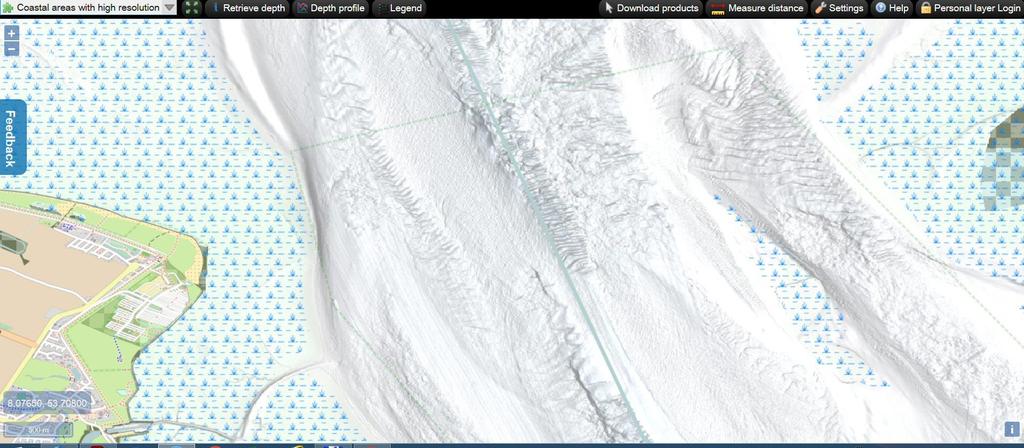
23 High Resolution DTMs for 3 pilot areas

24 Depth profile following user drawn transect

25 Download DTM tiles in various formats

26 Bathymetric DTM 3D-Viewer DTM loaded into 3D-Viewer as developed and freely downloadable from Geo-Seas, based upon NASA World Wind software

27 Bathymetric DTM 3D-Viewer DTM loaded into 3D-Viewer
 and EMODnet")

28 Comparison with GEBCO GEBCO General Bathymetric Chart of the Oceans (IHO IOC) and EMODnet Bathymetry DTM example in Tyrrhenian Sea near Sicily Italy and South Italy resolution EMODnet is 16 times higher


29 Cooperation with GEBCO Cooperation and synergy with GEBCO: EMODnet uses GEBCO to cover gaps. GEBCO uses EMODnet to improve its DTM
 use WMS as")

30 Example of use Example of usage: SOCIB (Baleares Spain) use WMS as baselayer for display where marine observation instruments are deployed
31 Services CDI Data Discovery and Access service: WMS and WFS service: GetCapabilities vice=wms&request=getcapabilities Bathymetry Viewing and Downloading service: WMS: WFS: WMST: WCS: under development for downloading user drawn polygons
32 EMODNet Bathymetry next phase Expanding partnership to include more data, also from third parties through the new EMODnet Data Ingestion project Expanding coverage from open sea to include coastal areas (Possibly) increasing overall resolution Multi-resolution layer with HRDTM where released by owners 3D viewing without plug-in Innovation: Latest DTM uses > survey data sets and composite DTMs from 31 data providers from 18 countries and GEBCO_2015 Latest DTM contains data points ( rows x columns) Reaching the limit => developing cloud process around GLOBE for higher performance of computations and improved quality by more interaction between regions and extra viewing and qc services
33
Towards a pan-european infrastructure for marine and ocean data management + Importance of standards
 Towards a pan-european infrastructure for marine and ocean data management + Importance of standards By Dick M.A. Schaap Technical Coordinator SeaDataNet & Coordinator EMODnet Bathymetry Hydrography Day,
Towards a pan-european infrastructure for marine and ocean data management + Importance of standards
 Towards a pan-european infrastructure for marine and ocean data management + Importance of standards By Dick M.A. Schaap MARIS Technical Coordinator SeaDataNet & ODIP Coordinator EMODnet Bathymetry Münster
SeaDataNet, Pan-European infrastructure for marine ands ocean data management + EMODNET Preparatory Action Hydrographic and Seabed Mapping
 SeaDataNet, Pan-European infrastructure for marine ands ocean data management + EMODNET Preparatory Action Hydrographic and Seabed Mapping By Dick M.A. Schaap Technical Coordinator SeaDataNet & Coordinator
SeaDataNet, Pan-European infrastructure for marine and ocean data management + EMODNET Bathymetry
 SeaDataNet, Pan-European infrastructure for marine and ocean data management + EMODNET Bathymetry By Dick M.A. Schaap Technical Coordinator SeaDataNet & Coordinator EMODNet Bathymetry Limassol Cyprus,
European Marine Data Exchange
 European Marine Data Exchange By Dick M.A. Schaap MARIS (NL) EU SeaDataNet Technical Coordinator EU EMODnet Ingestion Coordinator Noordzeedagen 2018 - October 2018 Acquisition of ocean and marine data
SeaDataNet, Pan-European infrastructure for marine and ocean data management + EMODNET
 SeaDataNet, Pan-European infrastructure for marine and ocean data management + EMODNET By Dick M.A. Schaap Technical Coordinator SeaDataNet & Coordinator EMODNet Bathymetry San Francisco USA, 13 December
SeaDataNet, Pan-European infrastructure for ocean and marine data management & EMODNET Preparatory Actions Hydrographic Lot
 SeaDataNet, Pan-European infrastructure for ocean and marine data management & EMODNET Preparatory Actions Hydrographic Lot By Dick M.A. Schaap MARIS Brest, Sept 2009, GEBCO Science Day Supported by the
Data discovery and access via the SeaDataNet CDI system
 Data discovery and access via the SeaDataNet CDI system Central dataproducts and data services on distributed data. Peter Thijsse MARIS CLIPC IS-ENES workshop, KNMI, November 2014 Outline 1. Introduction
Pan-European infrastructure for management of marine and ocean geological and geophysical data Geo-Seas portal Data Discovery and Access Service
 Pan-European infrastructure for management of marine and ocean geological and geophysical data Geo-Seas Data Discovery and Access Service By Kathrin Manolis BGR and Dick M.A. Schaap Geo-Seas Technical
Introduction of SeaDataNet and EMODNET Working towards a harmonised data infrastructure for marine data. Peter Thijsse MARIS
 Introduction of SeaDataNet and EMODNET Working towards a harmonised data infrastructure for marine data Peter Thijsse MARIS CLIPC & IS-ENES 2 workshop, KNMI, November 2014 Outline 1. Introduction to marine
Geo Seas A pan European infrastructure for the management of marine geological and geophysical data
 Geo Seas A pan European infrastructure for the management of marine geological and geophysical data Colin Graham (BGS), Dick Schaap (MARIS), Paolo Diviacco (OGS) & Helen Glaves (BGS) Integrated Infrastructure
Data Product Catalogue. T. Loubrieu, M. Treguer, G. Maudire, IFREMER
 Data Product Catalogue T. Loubrieu, M. Treguer, G. Maudire, IFREMER High level Scope / Requirements Product definition : result of an action or process (aiming at fulfilling user's demand). For seadatanet
Copyright: C.Zampicinini - Fotolia
 Copyright: C.Zampicinini - Fotolia WHAT IS EMODNET? Network of +120 organizations assembling marine data, data products and metadata from diverse sources within Europe in a uniform way Aim = to unlock
Crowd-Sourced Bathymetry
 THE INTERNATIONAL HYDROGRAPHIC ORGANIZATION Crowd-Sourced Bathymetry NIOHC16 Chittagong, Bangladesh 14-16 March 2016 We know more about the topography of Mars and our Moon than we do about the topography
Guidelines for metadata, data and DTM QA/QC
 European Marine Observation and Data Network Guidelines for metadata, data and DTM QA/QC Service Contract for Lot 1 Bathymetry Modifications Version Date Authors Comments 1.0 2009/12/03 P. Hunter, B. Loubrieu,
Technical implementation plan for next period
 Technical implementation plan for next period Dick MA Schaap SeaDataCloud Technical Coordinator SDC Review, Brussels Belgium, 6 December 2018 Technical development lines Upgrading of CDI service Developing
FP7-INFRASTRUCTURES Grant Agreement no Scoping Study for a pan-european Geological Data Infrastructure D 4.4
 FP7-INFRASTRUCTURES-2012-1 Grant Agreement no. 312845 Scoping Study for a pan-european Geological Data Infrastructure D 4.4 Report on recommendations for implementation of the EGDI Deliverable number D4.4
h p://seadatanet.maris2.nl/newsle er.asp?v0=6
 1 sur 26 20/02/2012 16:15 Newsle er Content: 15 March 2011 Foreword SeaDataNet - present status and new features Geo-Seas project, extending SeaDataNet to marine geology and geophysics EMODNet Hydrography
SAFER the GIGAS Effect
 SAFER the GIGAS Effect How INSPIRE, GMES and GEOSS are influencing EC projects Arnaud Cauchy 23/06/2010 Agenda GIGAS Project Summary SAFER Project Summary SAFER Original Approach GIGAS Influences SAFER
European Location Framework (ELF) acting as a facilitator implementing INSPIRE
 acting as a facilitator implementing INSPIRE") www.eurogeographics.org European Location Framework (ELF) acting as a facilitator implementing INSPIRE Saulius Urbanas, Mick Cory (EuroGeographics) 29 October 2016 Copyright 2013 EuroGeographics EuroGeographics
www.eurogeographics.org European Location Framework (ELF) acting as a facilitator implementing INSPIRE Saulius Urbanas, Mick Cory (EuroGeographics) 29 October 2016 Copyright 2013 EuroGeographics EuroGeographics
21 st BSHC Meeting Agenda item C September 2016 BSBD-WG Report Klaipeda, Lithuania
 21 st BSHC Meeting Agenda item C3 27 29 September 2016 BSBD-WG Report Klaipeda, Lithuania Sweden BSBD-WG Report to the BSHC 21 st Conference The Baltic Sea Bathymetry Database Working Group has not held
SeaDataNet, EMODnet and Operational Oceanography in the Adriatic
 SeaDataNet, EMODnet and Operational Oceanography in the Adriatic G.M.R. Manzella 2/45 Data is being used by a far broader community than ever before; Metadata are critical for recording the provenance
Webservice-energy.org GEO Community Portal & Spatial Data Infrastructure for Energy
 Webservice-energy.org GEO Community Portal & Spatial Data Infrastructure for Energy Lionel Menard / Oct. 23 2017 Centre Observation, Impacts, Energy Research activities: Use of Earth observation data (Models,
Publishable summary for SeaDataNet III
 -1- Publishable summary for SeaDataNet III Executive summary. (The length of this part cannot exceed 1 page) SeaDataNet is the leading network in Europe, actively operating and developing a pan- European
CREATING SMART TRANSPORT SERVICES BY FACILITATING THE RE-USE OF OPEN GIS DATA
 OPEN TRANSPORT NET TOMAS MILDORF 16 JUNE 2014 INSPIRE CONFERENCE 2014, AALBORG, DENMARK CREATING SMART TRANSPORT SERVICES BY FACILITATING THE RE-USE OF OPEN GIS DATA 2 1 OTN AT A GLANCE Full title OpenTransportNet
CARIS MSDI Use Cases. Some examples of diverse projects
 CARIS MSDI Use Cases Some examples of diverse projects INTRODUCTION SDI underpins what we do 34 years developing GIS software Specializing in Hydrography for 30+ years Also cadastral, topographic and aeronautical
Operational Oceanography in Europe with focus on central/eastern Europe
 Operational Oceanography in Europe with focus on central/eastern Europe Hans Dahlin Director EuroGOOS Chair EC Expert Group on European Marine Observations and Data Exchange, Chair GMES Marine Core Service
The UK Marine Environmental Data and Information Network MEDIN
 The UK Marine Environmental Data and Information Network MEDIN M. Charlesworth, R. Lowry, H. Freeman, J. Rapaport, B Seeley Content MEDIN - a brief overview for context Discovery Metadata Standard and
Introduction to INSPIRE. Network Services
 Introduction to INSPIRE. Network Services European Commission Joint Research Centre Institute for Environment and Sustainability Digital Earth and Reference Data Unit www.jrc.ec.europa.eu Serving society
International Oceanographic Data and Information Exchange - Ocean Data Portal (IODE ODP)
") International Oceanographic Data and Information Exchange - Ocean Data Portal (IODE ODP) Enabling science through seamless and open access to marine data Credits This presentation was developed by: Mr.
International Oceanographic Data and Information Exchange - Ocean Data Portal (IODE ODP) Enabling science through seamless and open access to marine data Credits This presentation was developed by: Mr.
INSPIRE status report
 INSPIRE Team INSPIRE Status report 29/10/2010 Page 1 of 7 INSPIRE status report Table of contents 1 INTRODUCTION... 1 2 INSPIRE STATUS... 2 2.1 BACKGROUND AND RATIONAL... 2 2.2 STAKEHOLDER PARTICIPATION...
Towards a Canadian Integrated Ocean Observing System
 Towards a Canadian Integrated Ocean Observing System CMOS Luncheon (Ottawa) February 28, 2018 Andrew Stewart Fisheries and Oceans Canada The Ocean is Valuable Ocean Economy: Ocean-based industries Natural
Ocean Data Standards. Manuals and Guides 54 UNESCO
 ManualsandGuides54 Ocean Data Standards Volume 1 Recommendation to Adopt ISO 3166-1 and 3166-3 Country Codes as the Standard for Identifying Countries in Oceanographic Data Exchange UNESCO ManualsandGuides54
INTAROS Integrated Arctic Observation System
 INTAROS Integrated Arctic Observation System A project funded by EC - H2020-BG-09-2016 Coordinator: Stein Sandven Nansen Environmental and Remote Sensing Center, Norway Overall objective: to develop an
The European Commission s science and knowledge service. Joint Research Centre
 The European Commission s science and knowledge service Joint Research Centre GeoDCAT-AP The story so far Andrea Perego, Antonio Rotundo, Lieven Raes GeoDCAT-AP Webinar 6 June 2018 What is GeoDCAT-AP Geospatial
Metadata for Data Discovery: The NERC Data Catalogue Service. Steve Donegan
 Metadata for Data Discovery: The NERC Data Catalogue Service Steve Donegan Introduction NERC, Science and Data Centres NERC Discovery Metadata The Data Catalogue Service NERC Data Services Case study:
OceanBrowser: on-line visualization of gridded ocean data and in situ observations
 OceanBrowser: on-line visualization of gridded ocean data and in situ observations Alexander Barth¹, Sylvain Watelet¹, Charles Troupin², Aida Alvera Azcarate¹, Giorgio Santinelli³, Gerrit Hendriksen³,
INSPIRE & Environment Data in the EU
 INSPIRE & Environment Data in the EU Andrea Perego Research Data infrastructures for Environmental related Societal Challenges Workshop @ pre-rda P6 Workshops, Paris 22 September 2015 INSPIRE in a nutshell
Recommendation to Adopt ISO and Country Codes as the Standard for Identifying Countries in Oceanographic Data Exchange
 ManualsandGuides54(1) Recommendation to Adopt ISO 3166-1 and 3166-3 Country Codes as the Standard for Identifying Countries in Oceanographic Data Exchange UNESCO2010 IOCManualsandGuidesNo.54(1) Version1.0
THE ENVIRONMENTAL OBSERVATION WEB AND ITS SERVICE APPLICATIONS WITHIN THE FUTURE INTERNET Project introduction and technical foundations (I)
") ENVIROfying the Future Internet THE ENVIRONMENTAL OBSERVATION WEB AND ITS SERVICE APPLICATIONS WITHIN THE FUTURE INTERNET Project introduction and technical foundations (I) INSPIRE Conference Firenze,
ENVIROfying the Future Internet THE ENVIRONMENTAL OBSERVATION WEB AND ITS SERVICE APPLICATIONS WITHIN THE FUTURE INTERNET Project introduction and technical foundations (I) INSPIRE Conference Firenze,
Setting up the Ihlet Social Cadastre
 Setting up the Ihlet Social Cadastre Ihlet KHT Dr. Attila Molnár, GI consultant Bela Jarolics Rome, Italy TOPICS Goal of the project Architecture Database Solution Standards, communication Metadata Security
MARINE SDI FOR HYDROGRAPHIC HOW HYDROGRAPHIC SURVEYS CAN BENEFIT FROM IMPLEMENTATION OF MARINE SPATIAL DATA INFRASTRUCTURES
 MARINE SDI FOR HYDROGRAPHIC HOW HYDROGRAPHIC SURVEYS CAN BENEFIT FROM IMPLEMENTATION OF MARINE SPATIAL DATA INFRASTRUCTURES MAIN IMAGE: HafenCity: Produced by the Hamburg Port Authority using CARIS BASE
Contents. Introduction. CDI V3 Help Quick Search
 Contents Introduction... 1 A The interface... 2 A-1 Introduction... 2 A-2. Results list... 2 A-3: Additional menu options... 3 B. Searching the CDI entries metadata... 4 B-1 Narrowing down your result
Interoperability in Science Data: Stories from the Trenches
 Interoperability in Science Data: Stories from the Trenches Karen Stocks University of California San Diego Open Data for Open Science Data Interoperability Microsoft escience Workshop 2012 Interoperability
Reducing Consumer Uncertainty
 Spatial Analytics Reducing Consumer Uncertainty Towards an Ontology for Geospatial User-centric Metadata Introduction Cooperative Research Centre for Spatial Information (CRCSI) in Australia Communicate
Observation trends: Expectations from European Comission regarding data exchange and interoperability
 Observation trends: Expectations from European Comission regarding data exchange and interoperability Marcin Wichorowski (IO PAN), Sławomir Sagan (IO PAN), Declan Dunne (UCC MaREI), John Barton (UCC-TYNDALL)
HCA13-INF6. Submitted by:
 13 th Conference of the Hydrographic Commission on Antarctica (HCA) Cadiz, Spain, 3-5 December 2013 Information Paper Establishing the DCDB as a Global Digital Bathymetry Reference Data Store (Paper submitted
INSPIRE Conference 2018 (18 21 September, Antwerp)
") INSPIRE Conference 2018 (18 21 September, Antwerp) Introduction The Marine Strategy Framework Directive (MSFD) of the European Commission defines some obligations for the implementation of strategies for
INSPIRE Conference 2018 (18 21 September, Antwerp) Introduction The Marine Strategy Framework Directive (MSFD) of the European Commission defines some obligations for the implementation of strategies for
HUMBOLDT Application Scenario: Protected Areas
 CC by Erlend Schei Copyright by Kecko Copyright by Michael Bezzina CC by Gunnar Ries Copyright by Michael Bezzina Copyright by Michael Bezzina Copyright by Michael Bezzina CC by fs999 CC by Jordan Nielsen
Enabling Efficient Discovery of and Access to Spatial Data Services. CHARVAT, Karel, et al. Abstract
 Article Enabling Efficient Discovery of and Access to Spatial Data Services CHARVAT, Karel, et al. Abstract Spatial data represent valuable information and a basis for decision making processes in society.
Making Open Data work for Europe
 Making Open Data work for Europe Daniele Rizzi European Commission DG Communications Networks, Content and Technology daniele.rizzi@ec.europa.eu Nikolaos Loutas PwC EU Services nikolaos.loutas@be.pwc.com
Earth Observation Services in Collaborative Platforms
 Earth Observation Services in Collaborative Platforms Elecnor Deimos Overview Elecnor DEIMOS: the technology branch of ELECNOR Space is core business, with spillovers to Aerospace, Defense, Transport,
The geospatial metadata catalogue. FOSS4G Barcelona. Jeroen Ticheler. Founder and chair. Director
 The geospatial metadata catalogue FOSS4G2010 - Barcelona Jeroen Ticheler Director Founder and chair GeoNetwork opensource Dutch National Geo Registry FAO GeoNetwork SwissTopo geocat.ch GeoNetwork history
Spatial Data on the Web
 Spatial Data on the Web Tools and guidance for data providers The European Commission s science and knowledge service W3C Data on the Web Best Practices 35 W3C/OGC Spatial Data on the Web Best Practices
DanubeGIS User Manual Document number: Version: 1 Date: 11-Nov-2016
 DanubeGIS User Manual Document number: Version: 1 Date: 11-Nov-2016 Imprint Published by: ICPDR International Commission for the Protection of the Danube River ICPDR 2016 Contact ICPDR Secretariat Vienna
INSPIRE overview and possible applications for IED and E-PRTR e- Reporting Alexander Kotsev
 INSPIRE overview and possible applications for IED and E-PRTR e- Reporting Alexander Kotsev www.jrc.ec.europa.eu Serving society Stimulating innovation Supporting legislation The European data puzzle 24
Interoperability with ArcGIS
 Interoperability with ArcGIS Satish Sankaran Marten Hogeweg Agenda Understanding Interoperability What, Why and How? ArcGIS Platform An Open Platform Supporting Interoperability Examples from the real
SEIS. (Shared Environmental Information System) From concept to information services
 From concept to information services") SEIS (Shared Environmental Information System) From concept to information services Stefan Jensen EEA supported by Sheila Cryan and Jon Maidens GSDI 11, Rotterdam 19.6.2009 What is SEIS is about... Sharing
SEIS (Shared Environmental Information System) From concept to information services Stefan Jensen EEA supported by Sheila Cryan and Jon Maidens GSDI 11, Rotterdam 19.6.2009 What is SEIS is about... Sharing
GENeric European Sustainable Information Space for Environment.
 GENeric European Sustainable Information Space for Environment http://www.genesis-fp7.eu/ Outline Introduction The GENESIS FP7 project The GENESIS solution s architecture GENESIS experience with INSPIRE
This document is a preview generated by EVS
 TECHNICAL REPORT RAPPORT TECHNIQUE TECHNISCHER BERICHT CEN/TR 15449-5 April 2015 ICS 07.040; 35.240.70 English Version Geographic information - Spatial data infrastructures - Part 5: Validation and testing
PortalU, a Tool to Support the Implementation of the Shared Environmental Information System (SEIS) in Germany
 in Germany") European conference of the Czech Presidency of the Council of the EU TOWARDS eenvironment Opportunities of SEIS and SISE: Integrating Environmental Knowledge in Europe http:/www.e-envi2009.org/proceedings/
European conference of the Czech Presidency of the Council of the EU TOWARDS eenvironment Opportunities of SEIS and SISE: Integrating Environmental Knowledge in Europe http:/www.e-envi2009.org/proceedings/
Putting Your Data on the Map
 Putting Your Data on the Map Cyndy Chandler WHOI Marine Chemistry Department Woods Hole Data Mongers / Ocean Informatics Meeting 4 April 2007 - WHOI Finding the OI in WHOI What is Ocean Informatics? The
Testing - an essential aspect of establishing an SDI
 Testing - an essential aspect of establishing an SDI Clemens Portele, Anders Östman, Michael Koutroumpas, Xin He, Janne Kovanen, Markus Schneider, Andriani Skopeliti INSPIRE Conference 2011 30 June 2011
GGC35/2/5 Meeting 35 8 November 2018 Agenda Item 2.5 IHO DATA CENTRE FOR DIGITAL BATHYMETRY REPORT. Submitted by Director IHO DCDB SUMMARY
 GGC GGC35/2/5 Meeting 35 8 November 2018 Agenda Item 2.5 IHO DATA CENTRE FOR DIGITAL BATHYMETRY REPORT Submitted by Director IHO DCDB SUMMARY Executive Summary: This document provides details of the work
The GIGAS Methodology
 The GIGAS Methodology Pier Giorgio Marchetti European Space Agency Earth Observation Programme Ground Segment Department pier.giorgio.marchetti@esa.int GIGAS Objectives GIGAS has the goal to promote the
EarthLookCZ as Czech way to GMES
 EarthLookCZ as Czech way to GMES Karel Charvat 1 and Petr Horak 1 1 WirelessInfo, Czech Republic, charvat@wirelessinfo.cz Abstract Global Monitoring for Environment and Security is one of 4 ranges of solutions
GeoDCAT-AP Representing geographic metadata by using the "DCAT application profile for data portals in Europe"
 GeoDCAT-AP Representing geographic metadata by using the "DCAT application profile for data portals in Europe" Andrea Perego, Vlado Cetl, Anders Friis-Christensen, Michael Lutz, Lorena Hernandez Joint
The GeoPortal Cookbook Tutorial
 The GeoPortal Cookbook Tutorial Wim Hugo SAEON/ SAEOS SCOPE OF DISCUSSION Background and Additional Resources Context and Concepts The Main Components of a GeoPortal Architecture Implementation Options
Reducing Consumer Uncertainty Towards a Vocabulary for User-centric Geospatial Metadata
 Meeting Host Supporting Partner Meeting Sponsors Reducing Consumer Uncertainty Towards a Vocabulary for User-centric Geospatial Metadata 105th OGC Technical Committee Palmerston North, New Zealand Dr.
The IOC Project Office for IODE
 The IOC Project Office for IODE What activities do we undertake to achieve our objectives? Hosting of specialized short-term training courses and workshops in ocean data and information management, marine
Existing Solutions. Operating data services: Climate Explorer ECA&D climate4impact.eu data.knmi.nl
 Existing Solutions Operating data services: Climate Explorer ECA&D climate4impact.eu data.knmi.nl Wim Som de Cerff, KNMI R&D Observations and Data Technology sdecerff@knmi.nl Climate data services at KNMI
GEBCO Update. U.S. - Canada Hydrographic Commission Victoria, B.C., Canada 26 March 2018
 GEBCO Update U.S. - Canada Hydrographic Commission Victoria, B.C., Canada 26 March 2018 The Nippon Foundation-GEBCO Seabed 2030 The Seabed 2030 Establishment Team: Graham Allen, Robin Falconer, David Heydon,
EUDAT and Cloud Services
 EUDAT and Cloud Services Space Data & Cloud Computing Infrastructures: Policies and Regulations ESRIN, Frascati, 7 July 2017 Per Öster CSC-IT Center for Science Finland www.eudat.eu EUDAT receives funding
A Thematic Approach to Data Management and Implementation of INSPIRE: The UK Marine Environmental Data and Information Network
 A Thematic Approach to Data Management and Implementation of INSPIRE: The UK Marine Environmental Data and Information Network Mark Charlesworth mecha@bodc.ac.uk www.oceannet.org Content Importance marine
Welcome. to Pre-bid meeting. Karnataka State Spatial Data Infrastructure (KSSDI) Project, KSCST, Bangalore.
 Project, KSCST, Bangalore.") Welcome to Pre-bid meeting Karnataka State Spatial Data Infrastructure (KSSDI) Project, KSCST, Bangalore. DEVELOPMENT OF KARNATAKA STATE SPATIAL DATA INFRASTRUCTURE (KSSDI) PROJECT Objective: To develop
Welcome to Pre-bid meeting Karnataka State Spatial Data Infrastructure (KSSDI) Project, KSCST, Bangalore. DEVELOPMENT OF KARNATAKA STATE SPATIAL DATA INFRASTRUCTURE (KSSDI) PROJECT Objective: To develop
Initial Operating Capability & The INSPIRE Community Geoportal
 INSPIRE Conference, Rotterdam, 15 19 June 2009 1 Infrastructure for Spatial Information in the European Community Initial Operating Capability & The INSPIRE Community Geoportal EC INSPIRE GEOPORTAL TEAM
Interoperability Between GRDC's Data Holding And The GEOSS Infrastructure
 City University of New York (CUNY) CUNY Academic Works International Conference on Hydroinformatics 8-1-2014 Interoperability Between GRDC's Data Holding And The GEOSS Infrastructure Volker Andres Henning
Marine and Coastal Data Services in the Cloud. Richard Rombouts - Snowflake Software Ltd. & Keiran Millard SeaZone Solutions Ltd.
 Marine and Coastal Data Services in the Cloud Richard Rombouts - Snowflake Software Ltd. & Keiran Millard SeaZone Solutions Ltd. Marine Geospatial Data Inspired Marine Data? SeaZone HydroSpatial Global
INSPIRE tools What's new?
 INSPIRE tools What's new? Michael Lutz INSPIRE Conference, Antwerp 18 September 2018 Joint Research Centre The European Commission s science and knowledge service INSPIRE reference validator Why a reference
Research Infrastructures and Horizon 2020
 Ana Arana Antelo DG Research & Head of Research Infrastructures ERF Workshop - Hamburg, 31 May 2012 Research Infrastructures and Horizon 2020 The EU Framework Programme for Research and 2014-2020 Research
Transboundary data interoperability for Maritime Spatial Planning. Yuji KATO
 Transboundary data interoperability for Maritime Spatial Planning Yuji KATO CONTEXT THE MARITIME SPATIAL PLANNING DIRECTIVE DIRECTIVE 2014/89/EU establishing a framework for Maritime Spatial Planning (MSP)
Italy - Information Day: 2012 FP7 Space WP and 5th Call. Peter Breger Space Research and Development Unit
 Italy - Information Day: 2012 FP7 Space WP and 5th Call Peter Breger Space Research and Development Unit Content Overview General features Activity 9.1 Space based applications and GMES Activity 9.2 Strengthening
Hydrographic Services and Standards Committee. Dr Vasily Smolyanitsky, JCOMM ETSI chair
 Hydrographic Services and Standards Committee Report of the JCOMM Expert Team on Sea Ice Provision of improved marine weather information in graphical formats: practices for sea ice (SIGRID- 3/ Ice Objects
Validation in the Netherlands and European Location Framework
 Validation in the Netherlands and European Location Framework INSPIRE Workshop on validation and conformity testing 15 16 May 2014 Thijs Brentjens Contents Geonovum and ELF INSPIRE INSPIRE in the Netherlands
MY DEWETRA IPAFLOODS REPORT
 Grant Contract N. ECHO/SUB/2014/692292 Programme for Prevention, Preparedness and Response to Floods in the Western Balkans and Turkey IPA FLOODS Capacity Building Activities 2016 MY DEWETRA IPAFLOODS
The Global Context of Sustainable Development Data
 The Global Context of Sustainable Development Data Linda Hooper, UN Statistics Division UNDA10 - Workshop for ESCWA Sound Institutional, environment, cooperation, dialogue and partnerships for the production
Initial GMES Service for Geospatial Reference Data Access. Remote Sensing Department. INDRA ESPACIO
 Initial GMES Service for Geospatial Reference Data Access Remote Sensing Department. INDRA ESPACIO Brussels, 260-09-2011 CONTENT 01 Overview 02 EU-DEM 03 Hydrography 04 Production Coordination 05 Access
Toward Horizon 2020: INSPIRE, PSI and other EU policies on data sharing and standardization
 Toward Horizon 2020: INSPIRE, PSI and other EU policies on data sharing and standardization www.jrc.ec.europa.eu Serving society Stimulating innovation Supporting legislation The Mission of the Joint Research
ESFRI Strategic Roadmap & RI Long-term sustainability an EC overview
 ESFRI Strategic Roadmap & RI Long-term sustainability an EC overview Margarida Ribeiro European Commission DG Research & B.4 - Research Infrastructure Research and What is ESFRI? An informal body composed
/// INTEROPERABILITY BETWEEN METADATA STANDARDS: A REFERENCE IMPLEMENTATION FOR METADATA CATALOGUES
 /// Position Paper /// INTEROPERABILITY BETWEEN METADATA STANDARDS: A REFERENCE IMPLEMENTATION FOR METADATA CATALOGUES /// Keywords: Public administration, Metadata, Geographical Information, Geospatial
Observations and Measurements
 Observations and Measurements issues and upgrades Simon Cox CSIRO Exploration & Mining http://www.em.csiro.au Goal of Observations and Measurements Information model for Sensor Web Enablement consistent
Capturing ICAN end-user requirements for NETMAR
 Capturing ICAN end-user requirements for NETMAR Declan Dunne, CMRC d.dunne@ucc.ie ICAN Workshop 5, Oostende, 31 August - 2 September 2011 Outline! User Feedback! Geo-processing services! Cookbooks 2 User
LIST OF ACTIONS&DECISIONS FROM WENDWG-6. ACTIONS&DECISIONS (in bold, action by)
") LIST OF FROM -6 1. Opening and Administrative Arrangements 6/01 Membership Membership 6/02 UK to report to the NSHC Chair on the need for the designation of a new representative at IHB to update the Membership
LIST OF FROM -6 1. Opening and Administrative Arrangements 6/01 Membership Membership 6/02 UK to report to the NSHC Chair on the need for the designation of a new representative at IHB to update the Membership
Public Private Partnership based on the NSDI of Spain: Regulation and examples from the National Geographic Institute. Título. Sebastián Mas-Mayoral
 1 Public Private Partnership based on the NSDI of Spain: Regulation and examples from the National Geographic Institute. Título Sebastián Mas-Mayoral 2 PPP in Spain Public private partnership is usually
The NextGEOSS Project
 NextGEOSS GEOSS Interoperability workshop 28 August 2017 The NextGEOSS Project Marie-Francoise Voidrot, Bart De Lathouwer Open Geospatial Consortium Europe Nuno Catarino DEIMOS Head of Data Systems NextGEOSS
Leveraging OGC Services in ArcGIS Server. Satish Sankaran, Esri Yingqi Tang, Esri
 Leveraging OGC Services in ArcGIS Server Satish Sankaran, Esri Yingqi Tang, Esri GIS Creating and Managing Geo Information Products - Proprietary - Open Specifications - Standards Dissemination of Geo
Semantically enhancing SensorML with controlled vocabularies in the marine domain
 Semantically enhancing SensorML with controlled vocabularies in the marine domain KOKKINAKI ALEXANDRA, BUCK JUSTIN, DARROCH LOUISE, JIRKA SIMON AND THE MARINE PROFILES FOR OGC SENSOR WEB ENABLEMENT STANDARDS
Consolidation Team INSPIRE Annex I data specifications testing Call for Participation
 INSPIRE Infrastructure for Spatial Information in Europe Technical documents Consolidation Team INSPIRE Annex I data specifications testing Call for Participation Title INSPIRE Annex I data specifications
C3S Data Portal: Setting the scene
 C3S Data Portal: Setting the scene Baudouin Raoult Baudouin.raoult@ecmwf.int Funded by the European Union Implemented by Evaluation & QC function from European commission e.g.,fp7 Space call Selected set
EUDAT & SeaDataCloud
 EUDAT & SeaDataCloud SeaDataCloud Kick-off meeting Damien Lecarpentier CSC-IT Center for Science www.eudat.eu EUDAT receives funding from the European Union's Horizon 2020 programme - DG CONNECT e-infrastructures.