Emergency Response through Collaborative Crisis Management
|
|
|
- Paul Dawson
- 5 years ago
- Views:
Transcription
1 Emergency Response through Collaborative Crisis Management Bojan Cestnik Temida d.o.o. Ljubljana Slovenia Artur Rocha INESC Porto Porto Portugal Martin Endig IFF Magdeburg Germany

2 Contents Information technology and crisis management Collaborative crisis management in MEDSI GIS and geospatial interoperability Symbology and information fusion Conclusion
3 Introduction Advancing the field of crisis management in Europe Information as a resource The right information to the right people at the right time Integration from various sources in a meaningful way EU FP6 project MEDSI Employ modern IT to increase preparedness to respond in emergency situations
4 Relationship: damage - time Damage d4 d3 d2 d Turn-out time (min) Source: Swedish Rescue Service Agency, Karlstad, Risc Management Division


5 MEDSI partners
6 Collaborative Crisis Management Several organizations involved under coordination of Crisis Center Police Firemen Emergency Health&Care... other civilian organizations Hospitals Municipalities Meteorology Service Organizations need to act coordinately Exchange information Understand each others information Know real-time sensor data
7 Collaborative Crisis Management Requirements for collaborative crisis management distributed access to external data sources for real-time data using web services for regular data e.g: number of available beds in a Hospital e.g: water level provided by sensor networks using Open Geospatial Consortium (OCG) compliant implementations for GI e.g: meteorology /environmental information backed up by a large local repository for static data... some managed by MEDSI other uploaded to the crisis center upon agreement with the responsible organization
8 Collaborative Crisis Management Requirements for collaborative crisis management (cont.) distributed work environment also inside the crisis center need for workflow support need to freeze and share a view of the work environment including GI views! common understanding of symbology symbology generator based on metadata descriptions
9 Interoperable GI Access Use of an OGC compliant WMS and WFS client to access external geo-data sources but also internal geo-data sources Finding registered data sources by means of a Catalog Service Currently, MEDSI prototype is accessing data from a deegree server a GeoMedia (Intergraph) server a UMN MapServer
10 Interoperable GI Access I Crisis Management Center MEDSI rich client Other EM Specific Tools Symbology Generator WMS&WFS Client Analysis Tools Planning Tools Catalog Browser External GI Providers MEDSI server side OGC Web Feature Server File Upload Service OGC Web Feature Server OGC Web Map Server Catalog Service Geo-data Sources E.g.: Environmental/Weather Monitoring Service Uploaded Geo-data MEDSI DB (geocoded objects) Orthophotos/ Raster Data Other Web Services OGC Web Map Server Geo-data Sources E.g.: Satellite Imagery Service
11 Interoperable GI Access II WMS / WFS 1 MEDSI Schema Geo Data Info Sources View Management Catalog Catalog Symbology Symbology Operations Operations Reports Reports Planning Planning Analysis Analysis Administration Administration Information Information Collection Collection Dissemination Dissemination Web Services Communication Communication Web Service Common Alerting Protocol
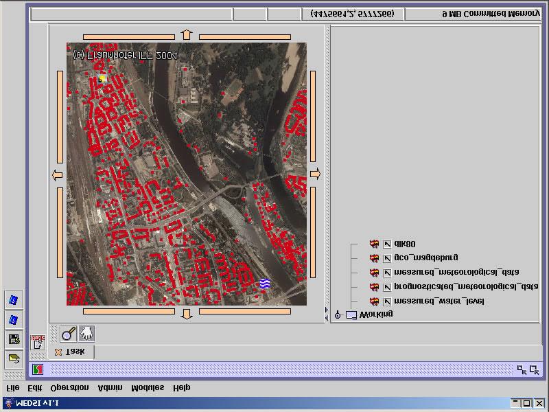
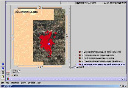
12 Interoperable GI Access

13 Symbology Representation of objects on the map point, line, area, volume Information content of a map with symbols cognitive methods, information overload Information fusion simplification generalization symbolization
, generated symbols Commonly used symbols")

14 Symbology Symbol components: Principles: Stored icons (32x32), generated symbols Commonly used symbols Minimize symbol confusion Additional information with graphic operations Example: blurred symbol for uncertainty
15 Overview of modern trends I OGC ( SMS (Style Management Service): mapping from features to parametrized symbols SLD (Styled Layer Descriptor): XML based descriptor Kent State University, Ohio (U. Dymon) Symbology analysis Theoretical framework for designing emergency mapping symbols State university of New York at Buffalo (A. Bisantz et al.) Cognitive approaches to symbology aiming at increasing human performace Information content of a map - information overload, data fusion, information fusion Approaches to dynamic symbol design Evaluation based on experiments
: Standard Geospatial Symbology 30.3.2005 16")
16 Overview of modern trends II Approach to standardization United States Department of Agriculture (2004): Standard Geospatial Symbology

17 Symbology Basic icons browser:


18 Symbology Generated symbols I:

19 Symbology Generated symbols II: Sport F Industry F Athletics Bernabeu Factory Paint Bruguer First level Second level Third level Speciality Name Activities Documents Equipment Events Files Imagery Organizations People Places Relationship Airport facilities Harbour facilities General civil facilities Cultural facilities Mass media facilities Free time facilities Sport facilities Telecommunications facilities Firms facilities Electrical facilities Railway facilities Governmental facilities Hydraulic facilities Hydroelectric facilities Industrial facilities International facilities Law facilities Military facilities Oil bearing facilities Police facilities Chemical facilities Religious facilities Medical facilities Firemen facilities Natural spaces
20 Symbology ontology Atmosphere (Objects, Events, Processes) Ocean (Objects, Events, Processes) Hydrology Surface hydrology (Objects, Events, Processes) Groundwater (Objects, Events, Processes) Terestrial ecology Plants (Objects, Events, Processes) Animals (Objects, Beeings, Events, Processes) Urban Ecology, environment (Physical objects; Individual living beeings; Social entities; Events, incidents; Processes) Sociology, people, citizen (PISEP) Economics, commercial (PISEP) Administration, law (PISEP) Transportation Objects or substances moved (PISEP) Modes of transport (Rail; Road; Sea, lake, river; Air) Fixed infrastructure nodes (PISEP) Fixed infrastructure links (PISEP)

21 Symbology Demo symbol transparency
22 Conclusion Collaborative crisis management in MEDSI Web services: from external datasources to sensor networks interfacing The issue of data ownership: legislative framework, standardization Symbology: cognitive view, ontology, standards Further work: next iteration within MEDSI Symbology line, area, volume dynamic symbol generation
Slovenian System of Protection against
 28 th European International Military Press Conference Association Congress Slovenia, 19-22 September 2007 Climate Change Impacts and Adaptation: Reducing Water-related Risks in Europe Slovenian System
Introduction to INSPIRE. Network Services
 Introduction to INSPIRE. Network Services European Commission Joint Research Centre Institute for Environment and Sustainability Digital Earth and Reference Data Unit www.jrc.ec.europa.eu Serving society
INSPIRE overview and possible applications for IED and E-PRTR e- Reporting Alexander Kotsev
 INSPIRE overview and possible applications for IED and E-PRTR e- Reporting Alexander Kotsev www.jrc.ec.europa.eu Serving society Stimulating innovation Supporting legislation The European data puzzle 24
PA Homeland Security/Public Safety Geospatial Portal Applications
 PA Homeland Security/Public Safety Geospatial Portal Applications ESRI FedUC 2006 Washington, DC Jim Knudson (jknudson@state.pa.us) Stacey White (stwhite@state.pa.us) GTO Homeland Security Priorities Understanding
THE ENVIRONMENTAL OBSERVATION WEB AND ITS SERVICE APPLICATIONS WITHIN THE FUTURE INTERNET Project introduction and technical foundations (I)
") ENVIROfying the Future Internet THE ENVIRONMENTAL OBSERVATION WEB AND ITS SERVICE APPLICATIONS WITHIN THE FUTURE INTERNET Project introduction and technical foundations (I) INSPIRE Conference Firenze,
ENVIROfying the Future Internet THE ENVIRONMENTAL OBSERVATION WEB AND ITS SERVICE APPLICATIONS WITHIN THE FUTURE INTERNET Project introduction and technical foundations (I) INSPIRE Conference Firenze,
ERDAS APOLLO Managing and Serving Geospatial Information
 ERDAS APOLLO Managing and Serving Geospatial Information ERDAS APOLLO Do you have large volumes of geospatial information, regularly updated data stores, and a distributed user base? Do you need a single,
RoMA: Resilience enhancement Of a Metropolitan Area
 RoMA: Resilience enhancement Of a Metropolitan Area Alberto Tofani- ENEA CRITIS 2017 Project Dissemination Lucca, 10/10/2017 RoMA Project RoMA is an Italian project Funded by MIUR (Ministry of Education,
Critical Infrastructure
 Critical Infrastructure 1 Critical Infrastructure Can be defined as any facility, system, or function which provides the foundation for national security, governance, economic vitality, reputation, and
Disaster Management (DM) Program Overview
 Program Overview") Disaster Management (DM) Program Overview Presented to Governing Board of the National Public Safety Telecommunications Council Chip Hines Program Manager Disaster Management e-gov Initiative Science and
Disaster Management (DM) Program Overview Presented to Governing Board of the National Public Safety Telecommunications Council Chip Hines Program Manager Disaster Management e-gov Initiative Science and
Oracle 10g GeoSpatial Technologies. Eve Kleiman Asia/Pacific Spatial Product Manager Oracle Corporation
 Oracle 10g GeoSpatial Technologies Eve Kleiman Asia/Pacific Spatial Product Manager Oracle Corporation Eve.Kleiman@oracle.com Agenda Market and Technology Trends Oracle GeoSpatial Technology Stack What
MY DEWETRA IPAFLOODS REPORT
 Grant Contract N. ECHO/SUB/2014/692292 Programme for Prevention, Preparedness and Response to Floods in the Western Balkans and Turkey IPA FLOODS Capacity Building Activities 2016 MY DEWETRA IPAFLOODS
A Perspective on Public Safety and Critical Infrastructure Protection
 A Perspective on Public Safety and Critical Infrastructure Protection Vision and market trends for Homeland Security and role in Critical Infrastructure Protection in response to the new security situation
Integrated Map Tool. Overview, Current Status, and Things to Come
 Integrated Map Tool Overview, Current Status, and Things to Come Integrated Mapping and Analysis Tool (IMAT) map widget Integrated Mapping Tool IMAT Reusable components for portrayal, query, analysis,
SITUATIONAL AWARENESS FOR NORTH CAROLINA S MODERN ENTERPRISE
 SITUATIONAL AWARENESS FOR NORTH CAROLINA S MODERN ENTERPRISE Joint Legislative Emergency Management Oversight Committee February 15, 2018 TigerSwan Headquarters: Apex, North Carolina, Founded 2008 Service-Disabled,
ArcGIS 9.2 Works as a Complete System
 ArcGIS 9.2 Works as a Complete System A New Way to Manage and Disseminate Geographic Knowledge Author/Serve/Use Maps Data Models Globes Metadata Use Desktop Explorer Web Map Viewer Mobile Open APIs Enterprise
How to use Water Data to Produce Knowledge: Data Sharing with the CUAHSI Water Data Center
 How to use Water Data to Produce Knowledge: Data Sharing with the CUAHSI Water Data Center Jon Pollak The Consortium of Universities for the Advancement of Hydrologic Science, Inc. (CUAHSI) August 20,
GEOSPATIAL ERDAS APOLLO. Your Geospatial Business System for Managing and Serving Information
 GEOSPATIAL ERDAS APOLLO Your Geospatial Business System for Managing and Serving Information ERDAS APOLLO Do you have large volumes of data, a geographicallydistributed user base and rapidly changing
Compass INSPIRE Services. Compass INSPIRE Services. White Paper Compass Informatics Limited Block 8, Blackrock Business
 Compass INSPIRE Services White Paper 2010 Compass INSPIRE Services Compass Informatics Limited Block 8, Blackrock Business Park, Carysfort Avenue, Blackrock, County Dublin, Ireland Contact Us: +353 1 2104580
GENeric European Sustainable Information Space for Environment.
 GENeric European Sustainable Information Space for Environment http://www.genesis-fp7.eu/ Outline Introduction The GENESIS FP7 project The GENESIS solution s architecture GENESIS experience with INSPIRE
ADVANCED GEOGRAPHIC INFORMATION SYSTEMS Vol. II - Geospatial Interoperability : The OGC Perspective Open Geospatial Consortium, Inc.
 GEOSPATIAL INTEROPERABILITY: THE OGC PERSPECTIVE Open Open Geospatial Consortium, Wayland, MA, USA Keywords: geographic information systems, geospatial services, interoperability, interface specification,
PRODUCT BROCHURE ERDAS APOLLO MANAGING AND SERVING GEOSPATIAL INFORMATION
 PRODUCT BROCHURE ERDAS APOLLO MANAGING AND SERVING GEOSPATIAL INFORMATION ERDAS APOLLO Do you have large volumes of geospatial information, regularly updated data stores, and a distributed user base? Do
IT Infrastructure for BIM and GIS 3D Data, Semantics, and Workflows
 IT Infrastructure for BIM and GIS 3D Data, Semantics, and Workflows Hans Viehmann Product Manager EMEA ORACLE Corporation November 23, 2017 @SpatialHannes Safe Harbor Statement The following is intended
Bringing Singapore to life in 3D
 Bringing Singapore to life in 3D Dr Victor Khoo, Deputy Director Singapore Land Authority Bringing Singapore to life in 3D ESRI Singapore UC 2016 Dr. Victor Khoo Singapore Land Authority SLA 2016 RESTRICTED
CRITICAL INFRASTRUCTURE AND KEY RESOURCES
 AGRICULTURE AND FOOD SECTOR The Agriculture and Food Sector has the capacity to feed and clothe people well beyond the boundaries of the nation. The sector is almost entirely under private ownership and
Seventh Framework Programme Security Research. Health Security Committee CBRN Section. 30 September by Clément Williamson
 Seventh Framework Programme 2007-2013 Security Research Health Security Committee CBRN Section 30 September 2009 by Clément Williamson clement.williamson@ec.europa.eu Work programme 2009 Info Day European
VirtualAgility solutions for. Smarter Public Safety. Michael V Kay VP European Operations VirtualAgility Inc.
 IBM Smarter Cities, Dublin 29th September 2010 Smarter Public Safety VirtualAgility solutions for Smarter Public Safety Michael V Kay VP European Operations VirtualAgility Inc. IBM is working across the
Setting up the Ihlet Social Cadastre
 Setting up the Ihlet Social Cadastre Ihlet KHT Dr. Attila Molnár, GI consultant Bela Jarolics Rome, Italy TOPICS Goal of the project Architecture Database Solution Standards, communication Metadata Security
European Location Framework (ELF) acting as a facilitator implementing INSPIRE
 acting as a facilitator implementing INSPIRE") www.eurogeographics.org European Location Framework (ELF) acting as a facilitator implementing INSPIRE Saulius Urbanas, Mick Cory (EuroGeographics) 29 October 2016 Copyright 2013 EuroGeographics EuroGeographics
www.eurogeographics.org European Location Framework (ELF) acting as a facilitator implementing INSPIRE Saulius Urbanas, Mick Cory (EuroGeographics) 29 October 2016 Copyright 2013 EuroGeographics EuroGeographics
Introduction to GeoServer
 Tutorial ID: This tutorial has been developed by BVIEER as part of the IGET web portal intended to provide easy access to geospatial education. This tutorial is released under the Creative Commons license.
Jeffery S. Horsburgh. Utah Water Research Laboratory Utah State University
 Advancing a Services Oriented Architecture for Sharing Hydrologic Data Jeffery S. Horsburgh Utah Water Research Laboratory Utah State University D.G. Tarboton, D.R. Maidment, I. Zaslavsky, D.P. Ames, J.L.
An Open Source Software approach to Spatial Data Infraestructures.
 Second Part INSPIRE and SDI: heterogeneous GI accessing solution An Open Source Software approach to Spatial Data Infraestructures. Study of different scenarios Second Part: INDEX I. Intro: SDI: Beginings,
Geospatial Intelligence Interoperability Through Standards Gordon C.Ferrari Chief, Content Standards and Interoperability Division
 Geospatial Intelligence Interoperability Through Standards Gordon C.Ferrari Chief, Content Standards and Interoperability Division 15 May 2002 NIMA Vision and Mission Statements National Imagery and Mapping
Metadata in EuroGEOSS project (WP5 Experience from Slovenia)
") Metadata in EuroGEOSS project (WP5 Experience from Slovenia) Barbara Medved-Cvikl barbara.medved-cvikl@bf.uni-lj University of Ljubljana Biotechnical faculty Agenda Metadata what is it? About the role
Metadata in EuroGEOSS project (WP5 Experience from Slovenia) Barbara Medved-Cvikl barbara.medved-cvikl@bf.uni-lj University of Ljubljana Biotechnical faculty Agenda Metadata what is it? About the role
July 31, University of Maryland Emergency Management Faculty Staff Essentials
 July 31, 2015 University of Maryland Emergency Management Faculty Staff Essentials What is Emergency Management? 2 What is Emergency Management? The process of preparing for, mitigating, responding to
SMARTERDECISIONS. Geospatial Portal 2013 Open Interoperable GIS/Imagery Services with ERDAS Apollo 2013 and ERDAS Imagine 2013
 Geospatial Portal 2013 Open Interoperable GIS/Imagery Services with ERDAS Apollo 2013 and ERDAS Imagine 2013 Carahsoft Intergraph Government Solutions SMARTERDECISIONS Geospatial Portal 2013 Geospatial
INSPIRE in a nutshell, and overview of the European Union Location Framework
 INSPIRE in a nutshell, and overview of the European Union Location Framework Francesco Pignatelli European Commission, DG JRC 10 th European Congress and Exhibition on Intelligent Transport Systems and
NATIONAL CAPITAL REGION HOMELAND SECURITY STRATEGIC PLAN SEPTEMBER 2010 WASHINGTON, DC
 NATIONAL CAPITAL REGION HOMELAND SECURITY STRATEGIC PLAN SEPTEMBER 2010 WASHINGTON, DC Draft Version incorporating Management Review [MR] Edits and Comments Document Date: July 2013 Goal One: Ensure Interoperable
Understanding users workflows
 Understanding users workflows GloFAS current and future data services Fredrik Wetterhall 1 University of Leeds 6 September 2017 Objective of the talk and exercise 1. Demonstrate how GloFAS data is disseminated
1 Introduction. 2 National Data Exchange Layer
 Spatial Services in the egovernment: Delivering WFS and WMS Queries through the Data Exchange Layer of the Finnish National Architecture for Digital Services Pekka Latvala, Lassi Lehto Finnish Geospatial
Smart City Solutions for Small City
 Smart City Solutions for Small City Jurijs Strods Jelgava, Latvia jurijs.strods@dome.jelgava.lv Nordic-Baltic solutions for smarter cities in the region 07.09.2017 JELGAVA CITY INFOGRAPHIC 2 Fourth largest
Lecture note on the history and principles of geo-webservices
 A SHORT INTRODUCTION TO GEO-WEBSERVICES Lecture note on the history and principles of geo-webservices Barend Köbben Version 1.0 February 24, 2010 Contents 1 From monolithic to distributed GIS architectures
United Nations Spatial Data Infrastructure (UNSDI)
") United Nations Spatial Data Infrastructure (UNSDI) & UN Geographic Information Working Group (UNGIWG) T. Suha ÜLGEN Senior Advisor on Spatial Data Infrastructure Office of the Assistant Secretary-General
United Nations Spatial Data Infrastructure (UNSDI) & UN Geographic Information Working Group (UNGIWG) T. Suha ÜLGEN Senior Advisor on Spatial Data Infrastructure Office of the Assistant Secretary-General
 http://ipafloods.mydewetra.org 1 My Dewetra IPA FLOODS FLOOD RISK Information System Support the Approximation of EU Floods Directive Compliancy with International standards (INSPIRE, OGC) and protocols
Windsor Essex Environmental Metadata System (WEEMS)
") Windsor Essex Environmental Metadata System (WEEMS) Utilizing Open Source Geospatial Metadata Technologies For Making g Research Based Data Available for Collaboration Grgicak-Mannion, A 1., Ciborowski,
Windsor Essex Environmental Metadata System (WEEMS) Utilizing Open Source Geospatial Metadata Technologies For Making g Research Based Data Available for Collaboration Grgicak-Mannion, A 1., Ciborowski,
National Policy and Guiding Principles
 National Policy and Guiding Principles National Policy, Principles, and Organization This section describes the national policy that shapes the National Strategy to Secure Cyberspace and the basic framework
CAPACITY BUILDING WORKSHOP FOR TRAFFIC MANAGEMENT INFORMATION CONTROL CENTRES (TMICC) AND NATIONAL URBAN TRANSPORT HELPLINE (NUTH)
 AND NATIONAL URBAN TRANSPORT HELPLINE (NUTH)") Topic Covered Session 3A Institutional Considerations and Organizational Setting for TMICC and NUTH Outline Transport: Role of Various Government Levels TMICC Stakeholders in Traffic Management Potential
Topic Covered Session 3A Institutional Considerations and Organizational Setting for TMICC and NUTH Outline Transport: Role of Various Government Levels TMICC Stakeholders in Traffic Management Potential
Office DEPOT 1. Table of Contents. About Office Depot Global HQ in Delray Beach, FL. May 5-7, 2008
 Continuity Insights Management Conference 2008 -------------------------------------------- Public-Private Private Partnerships: A Grass-Roots Approach Presented By: Tom Serio Director - Global Business
Accessing OGC Services To access OGC WMS and WFS open the service in the directory that you want to consume, and click on either WMS or WFS.
 Using Web Services Web Services Overview This user guide contains instructions on how to consume a range of services through a range of both web based and desktop GIS applications. Web services are a live
Extend GIS. The Reach. Of Your GIS. Chris Cappelli Nathan Bennett
 Extend The Reach GIS Of Your GIS Chris Cappelli Nathan Bennett Where do your co-workers, managers, customers, and citizens go when they want to find or make a map? GIS is a practical system for problem
Managing Imagery and Raster Data using Mosaic Datasets
 Esri European User Conference October 15-17, 2012 Oslo, Norway Hosted by Esri Official Distributor Managing Imagery and Raster Data using Mosaic Datasets Peter Becker ArcGIS is a Comprehensive Imagery
Deliverable D3.12. Contract number: OJEU 2010/S Deliverable: D3.12 Author: Igor Antolovic Date: Version: Final
 Deliverable D3.12 Final and public version of the implemented web site with full functionality that hosts all relevant information on the Climate Atlas of the Carpathian Region, including a public download
German Research Strategy in the Area of Civil Security Research
 8th Interdisciplinary Workshop on Global Security WISG 2014 German Research Strategy in the Area of Civil Security Research Eckhart Curtius Federal Ministry of Education and Research Division Security
A service oriented approach for geographical data sharing
 I3E 2005 Conference October 28-30, 2005" A service oriented approach for geographical data sharing Authors L. Vaccari 1, A. Ivanyuckovich 2, and M. Marchese 2 1 Autonomous Province of Trento, Trento, Italy
SAP HANA Spatial Location-based business platform
 SAP HANA Spatial Location-based business platform Thomas Hammer, HANA Spatial Development April 19, 2018 SAP HANA Architecture Application development All Devices SAP, ISV and Custom Applications SAP HANA
Kodagu District Disaster Management Plan
 Kodagu District map Message Deputy Commissioner Kodagu District Disaster Management Plan 2015-16 Content Index Page No. Abbreviation 1 Kodagu District Disaster Management Team 2 4 Chapter 1 INTRODUCTION
INSPIRE & Environment Data in the EU
 INSPIRE & Environment Data in the EU Andrea Perego Research Data infrastructures for Environmental related Societal Challenges Workshop @ pre-rda P6 Workshops, Paris 22 September 2015 INSPIRE in a nutshell
NTT Group s Commitment to Smart World. IoT Enables a Smart World
 NTT Group s Commitment to Smart World IoT Enables a Smart World 2 Las Vegas Public safety solution Creation of new values by Connected Ship Forecasting the people flow and optimizing the control method
BUILD AND MAINTAIN SAFE COMMUNITIES WITH ARCGIS ONE PLATFORM, MANY MISSIONS
 BUILD AND MAINTAIN SAFE COMMUNITIES WITH ARCGIS ONE PLATFORM, MANY MISSIONS SAFETY AND SECURITY IN THE 21ST CENTURY National security, defense, and public safety agencies face challenges and threats that
Interoperability Platform and Standardization Efforts
 Interoperability Platform and Standardization Efforts FP7-SEC-2013-1 Funded by European Commission Project ID 607768 ETSI Workshop Sophia Antipolis, 10 May 2016 REDIRNET - The static and streamed data
DATA INTEGRATION AT THE NATIONAL LEVEL
 DATA INTEGRATION AT THE NATIONAL LEVEL SERGEY EGORENKO DEPUTY HEAD, FEDERAL STATE STATISTICS SERVICE (ROSSTAT) 11-13 DECEMBER 2017 BANGKOK, THAILAND CENTRALIZED SYSTEM OF THE STATE STATISTICS WITH ELEMENTS
South East Region THIRA
 South East Region THIRA The THIRA follows a four-step process, as described in Comprehensive Preparedness Guide 201, Second Edition: 1. Identify the Threats and Hazards of Concern. Based on a combination
DMT Disaster Management Tool. Mohammed Khider, Michael Angermann, Martin Frassl, Michael Lichtenstern German Aerospace Center (DLR)
") DMT Disaster Management Tool Mohammed Khider, Michael Angermann, Martin Frassl, Michael Lichtenstern German Aerospace Center (DLR) Overview of the space based solutions used in disaster management Satellite
DMT Disaster Management Tool Mohammed Khider, Michael Angermann, Martin Frassl, Michael Lichtenstern German Aerospace Center (DLR) Overview of the space based solutions used in disaster management Satellite
Tutorial International Standards. Web Map Server (WMS) & Web Feature Server (WFS) Overview
 & Web Feature Server (WFS) Overview") ISO/TC 211 17 th Plenary & Associated Meetings Berlin, Germany, DIN Institute / 2003-10-31 Advisory Group on Outreach Tutorial International Standards Web Map Server (WMS) & Web Feature Server (WFS) Overview
ISO/TC 211 17 th Plenary & Associated Meetings Berlin, Germany, DIN Institute / 2003-10-31 Advisory Group on Outreach Tutorial International Standards Web Map Server (WMS) & Web Feature Server (WFS) Overview
DISASTER RISK MANAGEMENT INFORMATION SYSTEMS IN TAIWAN. Dean, College of Planning and Design National Cheng Kung University Taiwan
 DISASTER RISK MANAGEMENT INFORMATION SYSTEMS IN TAIWAN Prof. Feng-Tyan LIN Dean, College of Planning and Design National Cheng Kung University Taiwan Taiwan has been implementing National GIS Projects
THE LINK BETWEEN ENTERPRISE RISK MANAGEMENT AND DISASTER MANAGEMENT
 THE LINK BETWEEN ENTERPRISE RISK MANAGEMENT AND DISASTER MANAGEMENT International Recovery Forum 2014 ~ The Role of Private Sector in Disaster Recovery ~ 21 January 2014 Kobe, Japan Dr Janet L. Asherson
Leveraging OGC Services in ArcGIS Server. Satish Sankaran Yingqi Tang
 Leveraging OGC Services in ArcGIS Server Satish Sankaran ssankaran@esri.com Yingqi Tang ytang@esri.com Agenda Interoperability Enablers OGC and esri OGC Web Services ArcGIS and OGC Web Services - @ version
The Butterfly Effect. A proposal for distribution and management for butterfly data programs. Dave Waetjen SESYNC Butterfly Workshop May 10, 2012
 The Butterfly Effect A proposal for distribution and management for butterfly data programs Dave Waetjen SESYNC Butterfly Workshop May 10, 2012 http://butterfly.ucdavis.edu Citizen Science based Observation
Metadata for Data Discovery: The NERC Data Catalogue Service. Steve Donegan
 Metadata for Data Discovery: The NERC Data Catalogue Service Steve Donegan Introduction NERC, Science and Data Centres NERC Discovery Metadata The Data Catalogue Service NERC Data Services Case study:
RESOURCE ATLAS OVER THE WEB: PRELIMINARY RESULTS
 DISSEMINATION OF THE UAE SOLAR RESOURCE ATLAS OVER THE WEB: PRELIMINARY RESULTS and Research Center for Renewable Energy Mapping and Assessment Masdar Institute of Science and Technology, Abu Dhabi, United
Hippocrates. Situational Awareness Application ESRI. October, 2007
 Hippocrates New Jersey s Health System Situational Awareness Application ESRI October, 2007 New Jersey s Health System 8.7 million people 566 municipalities 114 local health departments 21 counties 22
International Oceanographic Data and Information Exchange - Ocean Data Portal (IODE ODP)
") International Oceanographic Data and Information Exchange - Ocean Data Portal (IODE ODP) Enabling science through seamless and open access to marine data Credits This presentation was developed by: Mr.
International Oceanographic Data and Information Exchange - Ocean Data Portal (IODE ODP) Enabling science through seamless and open access to marine data Credits This presentation was developed by: Mr.
Critical Infrastructure Analysis and Protection - A Case for Secure Information Exchange. August 16, 2016
 Critical Infrastructure Analysis and Protection - A Case for Secure Information Exchange Dennis Denham Ssempereza - CISA, CISM, CRISC August 16, 2016 About me! Involved in Risk Management and Security
gvsig: towards 4D GIS
 gvsig: towards 4D GIS Salvador Bayarri IVER Salvador.Bayarri@iver.es www.gvsig.gva.es Contents gvsig's background & updates 3D visualization in gvsig Time and Animation in gvsig Implementation plan Demo
Cisco Open Platform for Safety and Security
 Cisco Open Platform for Safety and Security 1 Agenda Market Overview Business Drivers Barriers and Risks Cisco Open Platform for Safety and Security Scenarios Ecosystem Partners Summary 2 Market Overview
Building a Europe of Knowledge. Towards the Seventh Framework Programme
 Building a Europe of Knowledge Towards the Seventh Framework Programme 2007-2013 FP7 /1 EUROPEAN COMMISSION - Research DG - November 2005 EU research: the story so far 1952: ECSC treaty; first projects
Relation between Geospatial information projects related to GBIF
 Relation between Geospatial information projects related to GBIF Synthesys 3.6-Synthesys 3.7-GBIF.DE- BioGeomancer The most up to date work can always be found at: http://www.biogeografia.com/synthesys
source: https://doi.org/ /boris downloaded: Version 1
 NAKINFO ONLINE source: https://doi.org/10.7892/boris.68367 downloaded: 13.3.2017 DEVELOPER S MANUAL Version 1 NakInfo Online Developer s Manual version 1, 2011 By Flametree Systems Engineering Ltd www.flametree
NFPA 3000 (PS) Standard for an Active Shooter / Hostile Event Response (ASHER) Program IT S A BIG WORLD. LET S PROTECT IT TOGETHER.
 Standard for an Active Shooter / Hostile Event Response (ASHER) Program IT S A BIG WORLD. LET S PROTECT IT TOGETHER.") NFPA 3000 (PS) Standard for an Active Shooter / Hostile Event Response (ASHER) Program IT S A BIG WORLD. LET S PROTECT IT TOGETHER. TM Active Shooter Incidents: 2000-2017 2 Active Shooter Incidents: 2016
NFPA 3000 (PS) Standard for an Active Shooter / Hostile Event Response (ASHER) Program IT S A BIG WORLD. LET S PROTECT IT TOGETHER. TM Active Shooter Incidents: 2000-2017 2 Active Shooter Incidents: 2016
FP7-INFRASTRUCTURES Grant Agreement no Scoping Study for a pan-european Geological Data Infrastructure D 4.4
 FP7-INFRASTRUCTURES-2012-1 Grant Agreement no. 312845 Scoping Study for a pan-european Geological Data Infrastructure D 4.4 Report on recommendations for implementation of the EGDI Deliverable number D4.4
International Civil Aviation Organization THE SECOND MEETING OF SYSTEM WIDE INFORMATION MANAGEMENT TASK FORCE (SWIM TF/2)
") SWIM TF/2 IP/09 Agenda Item 4 09-12/04/18 International Civil Aviation Organization THE SECOND MEETING OF SYSTEM WIDE INFORMATION MANAGEMENT TASK FORCE (SWIM TF/2) Bangkok, Thailand, 09 12 April 2018 Agenda
SWIM TF/2 IP/09 Agenda Item 4 09-12/04/18 International Civil Aviation Organization THE SECOND MEETING OF SYSTEM WIDE INFORMATION MANAGEMENT TASK FORCE (SWIM TF/2) Bangkok, Thailand, 09 12 April 2018 Agenda
Oracle Spatial Technologies: An Update. Xavier Lopez Director, Spatial Technologies Oracle Corporation
 Oracle Spatial Technologies: An Update Xavier Lopez Director, Spatial Technologies Oracle Corporation Overview Oracle Approach to Market Specialist v. Generalist Solutions New Developments: Oracle Database
IT Innovation Centre, University of Southampton, UK. Deutsches Geo-Forschungs-Zentrum - GFZ, Germany. Fraunhofer IOSB, Germany
 Collaborative, Complex and Critical Decision-Support in Evolving Crisis Multi-disciplinary approaches to intelligently sharing largevolumes of real-time sensor data during natural disasters Stuart E. Middleton
Web Services for Geospatial Mobile AR
 Web Services for Geospatial Mobile AR Introduction Christine Perey PEREY Research & Consulting cperey@perey.com Many popular mobile applications already use the smartphone s built-in sensors and receivers
Getting Ready for Public-Private Partnerships (P3s)
") THE POWER OF PERFORMANCE 51 TH ANNUAL CONFERENCE MAY 22-26, 2018 ORLANDO, FLORIDA Getting Ready for Public-Private Partnerships (P3s) Lawrence L Martin, Ph.D., MBA University of Central Florida TOPICS
THE POWER OF PERFORMANCE 51 TH ANNUAL CONFERENCE MAY 22-26, 2018 ORLANDO, FLORIDA Getting Ready for Public-Private Partnerships (P3s) Lawrence L Martin, Ph.D., MBA University of Central Florida TOPICS
What s New and Interesting with CAD and Mobile. Ed Sieja October 1 st, 2008 Mississauga, ON
 What s New and Interesting with CAD and Mobile Ed Sieja October 1 st, 2008 Mississauga, ON Disclaimer The enclosed product information is shared with its audience to provide an understanding of Intergraph
Homeland Security and Geographic Information Systems
 Page 1 of 5 Homeland Security and Geographic Information Systems How GIS and mapping technology can save lives and protect property in post-september 11th America Introduction Timely, accurate information,
, us Army Corps ~----,- 1 ' of Engineers Nashville District
 , us Army Corps ~----,- 1 ' of Engineers Nashville District The U.S. Army Corps of Engineers (Corps), through its Interagency and International Services (lis) program, provides: planning, engineering,
Smart City Solution & Case Study. LG Uplus
 Smart City Solution & Case Study LG Uplus LG Group & LGU+ LG Group Overview LG Group Founded in 1947, LG Group now has 3 main business domains Portfolio Revenue (USD) 9.6 B 10.2 B 11.0 B 2015 2016 2017
Leveraging OGC Standards on ArcGIS Server
 Leveraging OGC Standards on ArcGIS Server Satish Sankaran Interoperability and Standards Team James Michel III ESRI Intel Team ArcGIS Server Complete Interoperable Server-Based GIS Desktop Explorer Web
A holistic approach towards the first responder of the future
 A holistic approach towards the first responder of the future Dr. Dimitris Vassilliadis and Dr. Alexandros Bartzas Project Coordinator EXUS S.A. E-SPONDER is funded from the European Community s Seventh
Unified Incident Command and Decision Support (UICDS) Bridging the Gap with Common Operational Data Through the UICDS Information Exchange Middleware
 Bridging the Gap with Common Operational Data Through the UICDS Information Exchange Middleware") Unified Incident Command and Decision Support (UICDS) Bridging the Gap with Common Operational Data Through the UICDS Information Exchange Middleware James W. Morentz, Ph.D. UICDS Outreach Director The
Unified Incident Command and Decision Support (UICDS) Bridging the Gap with Common Operational Data Through the UICDS Information Exchange Middleware James W. Morentz, Ph.D. UICDS Outreach Director The
Information Needs and Flow for Disaster Management
 Information Needs and Flow for Disaster Management WU Guoxiang Chief, Space Technology Applications Section Information, Communication and Space Technology Division UN ESCAP Disaster reduction measures
Welcome. to Pre-bid meeting. Karnataka State Spatial Data Infrastructure (KSSDI) Project, KSCST, Bangalore.
 Project, KSCST, Bangalore.") Welcome to Pre-bid meeting Karnataka State Spatial Data Infrastructure (KSSDI) Project, KSCST, Bangalore. DEVELOPMENT OF KARNATAKA STATE SPATIAL DATA INFRASTRUCTURE (KSSDI) PROJECT Objective: To develop
Welcome to Pre-bid meeting Karnataka State Spatial Data Infrastructure (KSSDI) Project, KSCST, Bangalore. DEVELOPMENT OF KARNATAKA STATE SPATIAL DATA INFRASTRUCTURE (KSSDI) PROJECT Objective: To develop
Geo-spatial technology enables & enhances the objectives of Safe City - Smart City
 Geo-spatial technology enables & enhances the objectives of Safe City - Smart City Presented By: Mr. Shishir Verma Vice President MapmyIndia (CE Info Systems Pvt. Ltd.) About Us Making Our World Better
SEIS. (Shared Environmental Information System) From concept to information services
 From concept to information services") SEIS (Shared Environmental Information System) From concept to information services Stefan Jensen EEA supported by Sheila Cryan and Jon Maidens GSDI 11, Rotterdam 19.6.2009 What is SEIS is about... Sharing
SEIS (Shared Environmental Information System) From concept to information services Stefan Jensen EEA supported by Sheila Cryan and Jon Maidens GSDI 11, Rotterdam 19.6.2009 What is SEIS is about... Sharing
Vision for WMO Integrated Global Observing System (WIGOS) in 2040 Context, purpose, scope, and current status
 in 2040 Context, purpose, scope, and current status") Vision for WMO Integrated Global Observing System (WIGOS) in 2040 Context, purpose, scope, and current status Lars Peter Riishojgaard WMO Secretariat What is the WMO Integrated Global Observing System
Vision for WMO Integrated Global Observing System (WIGOS) in 2040 Context, purpose, scope, and current status Lars Peter Riishojgaard WMO Secretariat What is the WMO Integrated Global Observing System
DisasterHub. A mobile app Enabling crowd generated data fusion in Earth Observation disaster management
 DisasterHub A mobile app Enabling crowd generated data fusion in Earth Observation disaster management BEYOND Ecosystem (Services, products & infrastructure) What is the gap? Communication gap between
Android Team Awareness Kit (ATAK) and ArcGIS
 and ArcGIS") Android Team Awareness Kit (ATAK) and ArcGIS Darron Pustam Product Manager, Esri Craig Cleveland Product Engineer, Esri Verne LaClair Product Manager, PAR Agenda Connecting Intel and Operations in Real
Android Team Awareness Kit (ATAK) and ArcGIS Darron Pustam Product Manager, Esri Craig Cleveland Product Engineer, Esri Verne LaClair Product Manager, PAR Agenda Connecting Intel and Operations in Real
BSC Smart Cities Initiative
 www.bsc.es BSC Smart Cities Initiative José Mª Cela CASE Director josem.cela@bsc.es CITY DATA ACCESS 2 City Data Access 1. Standardize data access (City Semantics) Define a software layer to keep independent
Motions from the 91st OGC Technical and Planning Committee Meetings Geneva, Switzerland Contents
 Motions from the 91st OGC Technical and Planning Committee Meetings Geneva, Switzerland Contents "The Open Geospatial Consortium and EarthCube White Paper... 2 Vote for OGC Sensor Observation Service 2.0