Redistricting and Geographic Deployment at the Ottawa Police Service Esri Canada User Conference Ottawa October 12, 2017
|
|
|
- Augustine Simmons
- 6 years ago
- Views:
Transcription


1 Redistricting and Geographic Deployment at the Ottawa Police Service Esri Canada User Conference Ottawa October 12, 2017
2 Introduction Alyson Yaraskovitch, B.A., M.A. Crime Intelligence Analyst Ottawa Police Service
3 Adding some context BACKGROUND
4 Ottawa Police Service Initiative (SI) Created with the intention of addressing policing challenges in Ottawa Changing demographics, population growth, budget constraints, growing demand for service, and complexity of crime Frontline Deployment Project (FLD) Subgroup within SI Aimed at improving community safety and increasing the efficiency & efficacy of frontline services Redistricting Project (Part of FLD) Launched in late 2015, completed in mid-2016, implemented in early 2017

5 Previous Environment System created in Atoms Atoms grouped into 49 patrol Zones Zones grouped into 6 Districts Districts grouped into 3 Divisions Unit assigned to a patrol zone By 2015, units were responding to calls within their assigned zones approx. 32% of the time
6 OBJECTIVES & CONCEPT
7 Objectives Use an evidence-based approach Achieve per-unit workload parity across the City Achieve service goals and standards Reactive, Proactive, and Administrative time Optimize Priority 1 & 2 response performance Transition to Sector Policing Model Preservation of neighbourhood integrity Facilitate information sharing

8 Ottawa Neighbourhood Study (ONS) 108 neighbourhoods Neighbourhood profiles described by over 117 variables Four additional Crime variables added Intended to better define Ottawa neighbourhoods and measure and map neighbourhood social determinants of health amenable to policy interventions Data sources: Canadian Census, City of Ottawa, real estate maps, National Capital Commission, Ottawa Public Health, University of Ottawa, etc.
9 Research & Consultation Research best practices and consult academic literature Best practices survey disseminated to 12 police services (Canada and USA) Follow-up interviews with the three that were most comparable to our goals and jurisdiction Unique challenge: Ottawa s dense urban area and large rural area
10 Methodology Delineate urban and rural geography Calculate total 2015 service effort for each call and spatial join to ONS Neighbourhood Cluster ONS Neighbourhoods to create Sectors Esri Business Analyst extension, Territory Design solution (Urban/Suburban) ArcGIS Online, Location Allocation & Drive-Time Analysis (Rural) Validate model internally through user group feedback
11 The Data 2015 Computer Aided Dispatch (CAD) data Total service effort for all Priority 1 to 4 calls Service effort (reactive workload) = travel time + on scene time for all units All dispatchable unit types
12 Workload Total workload capacity per unit in a Sector Three (3) shifts (D/A/M) x hours = ~32 hrs Total workload capacity in a 24 hour period is 32 hours 32 hours per day x 365 days = 11,680 hrs per year Optimal (40% of Sector Total) range of 4,200 5,200 hrs per Unit Threshold limit of 6,000 hrs per unit
13 Workload 11,680 Hrs (Zone) 15 min/hr 10 min/hr 35 min/hr 25% ADMIN 2,920 Hrs/Yr 17% PROACTIVE 1,985 Hrs/Yr 58% REACTIVE 6,774 Hrs/Yr 11,680 Hrs (Sector) 12 min/hr 24 min/hr 24 min/hr Pre-Redistricting 40/40/20 20% ADMIN 2,336 Hrs/Yr 40% PROACTIVE 4,672 Hrs/Yr 40% REACTIVE 4,672 Hrs/Yr

14 Challenges Jurisdiction is 2,796 km 2 Call volume concentrated in populated areas Staffing allocation: which comes first? ONS neighbourhood boundary issues
15 THE MODEL


16 Esri Business Analyst Territory Design solution Create, automatically balance, and maintain territories Automated creation and dynamic editing


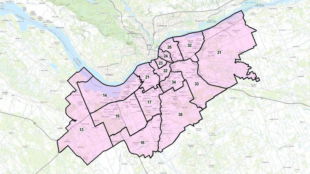
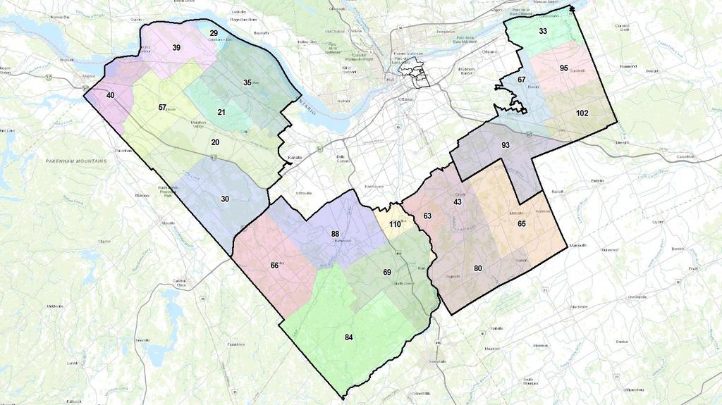
17 Urban Sector Creation Example*: Sector 16 Made up of 7 ONS neighbourhoods Sum of Service Effort Hours = 14,843.8 hrs 3 Units required Optimal Optimal Optimal * Not actual statistics. For demonstration purposes only.
18
19 What About Rural? Less densely populated; calls for service are fewer than in Urban areas Workload cannot be balanced with Urban Sectors Population more widely dispersed Takes longer to drive to calls Focus shifts from balancing workload to maintaining emergency response performance
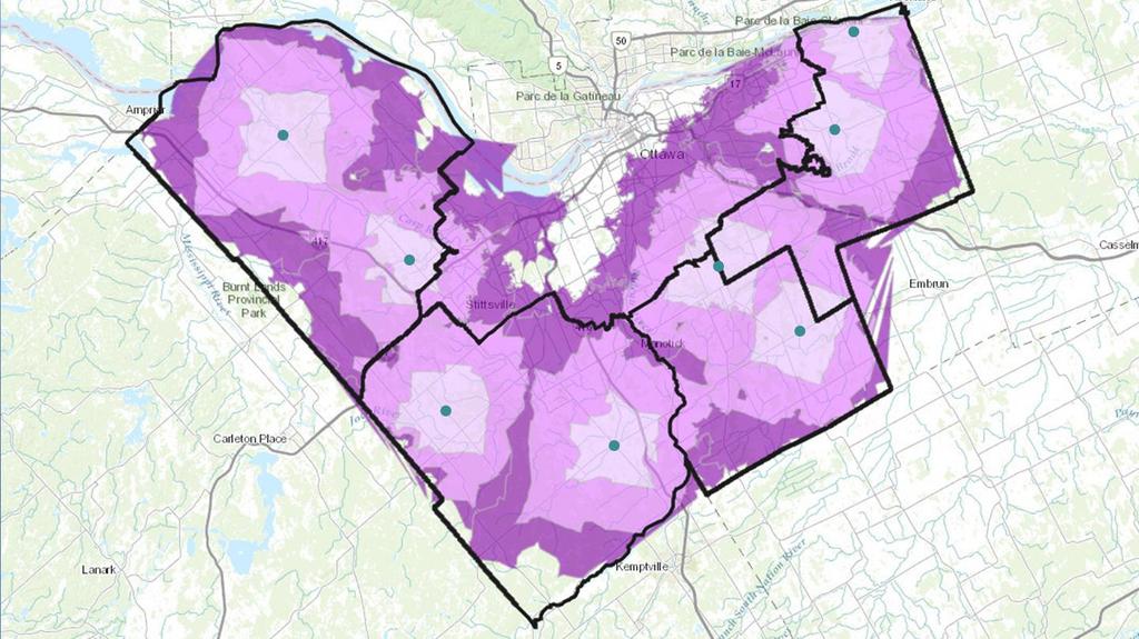
20 Rural Sector Design Same 2015 dataset used to design the Urban Sectors, but included Priority 1 & 2 calls only Identified 16 candidate locations with the highest call volume (population centres) Point Density tool Similar to Post Policing ArcGIS Online Location Allocation and Drive-Time Analysis used to identify the 8 best candidate locations from which the highest % of 2015 emergency calls could be reached within 15 min or less
21
22
23 Examining the model Validated using 2013 and 2014 workload data A series of workshops were held with frontline officers to review the proposed Sectors Considerations or concerns: Geographic and access issues Response considerations (backup) Officer safety concerns Points of interest / hot spots Future development
24 Accomplished Created a total of 19 patrol Sectors 15 Urban / Suburban 4 Rural Maintained ONS Neighbourhood integrity as much as possible Changes to shoreline, developing areas, Greenbelt, and Manotick Laid the foundation for the Staffing project Supported emergency response performance (in theory) Facilitated the sharing of information
25 QUESTIONS?
26 Alyson Yaraskovitch, B.A., M.A. Crime Intelligence Analyst Ottawa Police Service THANK YOU
York Regional Police. 20-Year Facilities Master Plan. Final Report
 York Regional Police 20-Year Facilities Master Plan Final Report Chris Polden January 25, 2017 2 Contents Introduction ORH Methodology Sector Policing Future Unit Requirement Station Location Optimization
Intelligent Enterprise meets Science of Where. Anand Raisinghani Head Platform & Data Management SAP India 10 September, 2018
 Intelligent Enterprise meets Science of Where Anand Raisinghani Head Platform & Data Management SAP India 10 September, 2018 Value The Esri & SAP journey Customer Impact Innovation Track Record Customer
SMART POLICING FOR SMALL AGENCIES. Increase Community Safety with Intelligent Maps and Analytics
 SMART POLICING FOR SMALL AGENCIES Increase Community Safety with Intelligent Maps and Analytics Build a more efficient, productive agency using powerful map analytics. For more than 20 years, law enforcement
Analysing crime data in Maps for Office and ArcGIS Online
 Analysing crime data in Maps for Office and ArcGIS Online For non-commercial use only by schools and universities Esri UK GIS for School Programme www.esriuk.com/schools Introduction ArcGIS Online is a
CITY COUNCIL AGENDA REPORT
 CITY COUNCIL AGENDA REPORT Subject: AUMA RESOLUTION BROADBAND INTERNET Recommendation(s) That the AUMA Broadband Resolution 2016, provided as Attachment 1 to the May 24, 2016 report entitled AUMA Resolution
Creating Transparency, Openness and Trust: Modern Approach to Redistricting
 Creating Transparency, Openness and Trust: Modern Approach to Redistricting Richard Leadbeater, Esri Jerry Howe, Utah Legislature Larry Boden, Esri NCSL Legislative Summit Sunday, Aug. 6 11:15 am-12:15
Facilities Master Plan Toronto Public Library Board Consultation
 STAFF REPORT INFORMATION ONLY Facilities Master Plan Toronto Public Library Board Consultation Date: May 28, 2018 20. To: From: Toronto Public Library Board City Librarian SUMMARY The purpose of this report
The role of municipal government in preventing crime and building community safety
 NATIONAL MUNICIPAL NETWORK ON CRIME PREVENTION Background and Reference Document Overview The National Municipal Network on Crime Prevention brings together Canadian municipalities from across the country
Dallas Police Department 2008 Summer Crime Prevention Initiative. June 6 August 24, 2008
 Dallas Police Department 2008 Summer Crime Prevention Initiative June 6 August 24, 2008 June 16, 2008 Issue Demands for police service generally increase during summer months due to increases in: Reported
It s in the Data: University-Police Collaborative Research
 It s in the Data: University-Police Collaborative Research Gary Bass: Moderator Bryan Kinney, Paul Brantingham, Dick Bent: Presenters The ICURS-Policing Big Data Research Experience Joint Research using
Converting census data into GIS data
 Converting census data into GIS data For those interested in analyzing Canadian demographics data, census data can be downloaded directly from ODESI or the Canadian Census Analyser. In order to use the
Texas Connector Training Manual. For TDCJ Users [2016]
![Texas Connector Training Manual. For TDCJ Users [2016]](/thumbs/79/80112153.jpg "Texas Connector Training Manual. For TDCJ Users [2016]") Texas Connector Training Manual For TDCJ Users [2016] CONTENTS OneStar Foundation and Texas Connector Overview... 3 The Data... 3 How To Log In... 4 TDCJ Quick Report Generator... 4 The Map... 8 Support
Texas Connector Training Manual For TDCJ Users [2016] CONTENTS OneStar Foundation and Texas Connector Overview... 3 The Data... 3 How To Log In... 4 TDCJ Quick Report Generator... 4 The Map... 8 Support
Pinellas Police Standards Council Post Retreat Opinion Survey
 Pinellas Police Standards Council Post Opinion Survey Survey Notes - October 23, 2003 The Pinellas Assembly asked the Pinellas Police Standards Council to help establish some priorities for the initiatives
Get a Second Opinion: Enterprise GIS Health Checks. David Crosby Esri Southeast Regional Professional Services Charlotte, NC
 Get a Second Opinion: Enterprise GIS Health Checks David Crosby Esri Southeast Regional Professional Services Charlotte, NC E M E R A L D S A P P H I R E T H A N K Y O U T O O UR SPONSORS What is an Enterprise
Northamptonshire 2020 Protecting you from harm.
 Northamptonshire 2020 Protecting you from harm The Background To review the current delivery model Gave an enhanced picture of current and emerging demands on the Force Enabled us to develop the most effective
Johnson City Regional ITS Architecture Update Review Workshop. March 12, 2015
 Johnson City Regional ITS Architecture Update Review Workshop March 12, 2015 Introductions Workshop Overview Review of the Draft Regional ITS Architecture Document Discussion on Existing and Planned ITS
THE REGIONAL MUNICIPALITY OF YORK
 THE REGIONAL MUNICIPALITY OF YORK Committee of the Whole Report of the Executive Director, Corporate and Strategic Planning ECONOMIC DEVELOPMENT ACTION PLAN UPDATE - YORK REGION BROADBAND STRATEGY PROGRESS
ROYAL CANADIAN MOUNTED POLICE (RCMP) - NORTH VANCOUVER DETACHMENT
 - NORTH VANCOUVER DETACHMENT") ROYAL CANADIAN MOUNTED POLICE (RCMP) - NORTH VANCOUVER DETACHMENT Mission The RCMP is Canada s national police service. Proud of our traditions and confi dent in meeting future challenges, we commit to
ROYAL CANADIAN MOUNTED POLICE (RCMP) - NORTH VANCOUVER DETACHMENT Mission The RCMP is Canada s national police service. Proud of our traditions and confi dent in meeting future challenges, we commit to
Sacramento Regional Crime Analysis Program
 Sacramento Regional Crime Analysis Program Progress Report 2017 Ruth M. Padilla Regional Crime Analyst Embedded at Sacramento Police Department Introduction The Community Corrections Partnership (CCP)
Municipal Parcel Mapping Workshop
 Municipal Parcel Mapping Workshop Presented to: Ontario Municipalities Presented by: Dave Gariepy, Director of Platform Content Dave Horwood, Land Information Systems Architect Sarah Sibbett, Senior Parcel
UNCLASSIFIED. National and Cyber Security Branch. Presentation for Gridseccon. Quebec City, October 18-21
 National and Cyber Security Branch Presentation for Gridseccon Quebec City, October 18-21 1 Public Safety Canada Departmental Structure 2 National and Cyber Security Branch National and Cyber Security
Connecting a Mobile York Region
 Connecting a Mobile York Region Presentation to ITS Canada Victoria 2014 Gregg Loane, P.Eng. June 1, 2014 Connecting a Mobile York Region Overview Who is York Region? York s ITS Program Background Data
MASAS. Overview & Backgrounder Document. Consultation Package. CanOps
 CanOps Overview & Backgrounder Document Consultation Package Defining CanOpS Multi-Agency Situational Awareness System () is a national information aggregation system that facilitates sharing situational
GIS for Law Enforcement
 White Paper GIS for Law Enforcement Author: John Beck Law Enforcement Specialist, Esri. Esri Australia Pty Ltd Level 3, 111 Elizabeth Street Brisbane Qld 4000 P +61 (0)7 3218 4100 F +61 (0)7 3211 1310
Spatial Analysis (Vector) II
 II") Spatial Analysis (Vector) II GEOG 300, Lecture 9 Dr. Anthony Jjumba 1 A Spatial Network is a set of geographic locations interconnected in a system by a number of routes is a system of linear features
Spatial Analysis (Vector) II GEOG 300, Lecture 9 Dr. Anthony Jjumba 1 A Spatial Network is a set of geographic locations interconnected in a system by a number of routes is a system of linear features
The What, Why, Who and How of Where: Building a Portal for Geospatial Data. Alan Darnell Director, Scholars Portal
 The What, Why, Who and How of Where: Building a Portal for Geospatial Data Alan Darnell Director, Scholars Portal What? Scholars GeoPortal Beta release Fall 2011 Production release March 2012 OLITA Award
Guelph Police Service
 Guelph Police Service The Guelph Police Service provides policing services to the City of Guelph and has an authorized complement of 196.5 police officers and 89.42 civilians. We serve our community by
Driving Canada s digital future
 Driving Canada s digital future Rob Malcolmson, Senior Vice President, Regulatory October 29, 2015 Canada s largest communications company Customer connections 21M+ Revenues $21B+ Enterprise value $74B
San Joaquin County Emergency Medical Services Agency
 San Joaquin County Emergency Medical Services Agency http://www.sjgov.org/ems Memorandum TO: All Interested Parties FROM: Rick Jones, EMS Analyst DATE: January, 19 Mailing Address PO Box French Camp, CA
Toronto s Resilience Strategy. Preliminary Resilience Assessment DRIE December
 Toronto s Resilience Strategy Preliminary Resilience Assessment DRIE December 12 2017 Purpose 1. Introduce Urban Resilience and the 100 Resilient Cities network 2. Share findings from our Preliminary Resilience
Coaldale RCMP Detachment. Public Information Session November 12 th 2014
 Coaldale RCMP Detachment Public Information Session November 12 th 2014 Core Values: Integrity Honesty Professionalism Compassion Respect This presentation will cover RCMP K Division Structure Law Enforcement
Beyond The Vector Data Model - Part Two
 Beyond The Vector Data Model - Part Two Introduction Spatial Analyst Extension (Spatial Analysis) What is your question? Selecting a method of analysis Map Algebra Who is the audience? What is Spatial
Woolwich CHC adopts the CIW as a strategic planning tool. A tool to shift the conversation. Using the CIW to advance community health and wellbeing
 Advancing health and wellbeing for individuals, families and communities AOHC and its members are using the Canadian Index of Wellbeing (CIW) as a powerful tool to support their efforts in making health
Office of the City Auditor 2014 Third Quarter Activity Report November 25, 2014
 2014 Third Quarter Activity Report November 25, 2014 This page is intentionally blank. 1. Audit Plan Progress Monitoring Bylaw 16097, Audit Committee Bylaw, Section 5 states that the Committee assists
Geo-spatial technology enables & enhances the objectives of Safe City - Smart City
 Geo-spatial technology enables & enhances the objectives of Safe City - Smart City Presented By: Mr. Shishir Verma Vice President MapmyIndia (CE Info Systems Pvt. Ltd.) About Us Making Our World Better
Justice Statistics: Access and Innovation
 Justice Statistics: Access and Innovation Ben Mazowita Analyst, Data Development Unit (DDU) Canadian Centre for Justice Statistics May 28, 2018 Data Liberation Initiative National Training Day 1 Canadian
Building partnerships and enhancing relationships for safer communities. RCMP in New Brunswick
 Building partnerships and enhancing relationships for safer communities RCMP in New Brunswick POLICE FIRE HEALTH Community Safety EMS EDUCATION Making a difference through partnerships and relationships
HEALTH INFORMATION INFRASTRUCTURE PROJECT: PROGRESS REPORT
 HEALTH INFORMATION INFRASTRUCTURE PROJECT: PROGRESS REPORT HCQI Expert Group Meeting 7-8 November 2013 Agenda to improve health information infrastructure» In 2010, health ministers called for improvement
CITY OF WINSTON-SALEM, NORTH CAROLINA Public Safety Needs Assessment Study Phase One EXECUTIVE SUMMARY
 EXECUTIVE SUMMARY I. Documentation and Current Conditions Establishment Process II. Existing Public Safety Facilities Analysis III. Space Allocation, Co-Location and Potential Site Location Analysis IV.
Grid-enabled Social Science
 Grid-enabled Social Science Yuwei Lin ESRC National Centre for e-social Science University of Manchester http://www.ncess.ac.uk What is Grid? Computational Grid Data Grid Collaboration Grid Sensor Grid
Delivering On Canada s Broadband Commitment Presentation to OECD/WPIE Public Sector Broadband Procurement Workshop December 4, 2002
 Delivering On Canada s Broadband Commitment Presentation to OECD/WPIE Public Sector Broadband Procurement Workshop December 4, 2002 Canada Demand Aggregation in a Federal Structure 3 major levels of government
Mobile Computing Technology and Applications
 Mobile Computing Technology and Applications Reed Pangborn December 3, 2008 Agenda Trends & Challenges Why Go Mobile? Public Safety Solutions Fleet & Asset Management Solutions Disaster Recovery/COOP Communications
US Geo-Explorer User s Guide. Web:
 US Geo-Explorer User s Guide Web: http://usgeoexplorer.org Updated on October 26, 2016 TABLE OF CONTENTS Introduction... 3 1. System Interface... 5 2. Administrative Unit... 7 2.1 Region Selection... 7
Annual Public Safety PSAP Survey results
 Annual Public Safety PSAP Survey results 573 PSAP Employees Surveyed March - July 2016 2016 Stratus Technologies. All Rights Reserved. 1 Stratus PSAP Survey March 2016 From March 2016 through July of 2016,
PUBLIC SAFETY. Little Haiti Kids Safe Day at Little Haiti Soccer Park, Dec. 30, 2016.
 PUBLIC SAFET Little Haiti Kids Safe Day at Little Haiti Soccer Park, Dec. 30, 2016. 8 Public Safety Overview Public safety continues to be a top priority among Miami residents. Having a safe and healthy
Using Custom Business Analyst Data Source Layers in ESRI Business Analyst Server
 An ESRI Technical Paper November 2009 Using Custom Business Analyst Data Source Layers in ESRI Business Analyst Server ESRI 380 New York St., Redlands, CA 92373-8100 USA TEL 909-793-2853 FAX 909-793-5953
A population grid for Andalusia Year Institute of Statistics and Cartography of Andalusia (IECA) Sofia (BU), 24 th October 2013
 Sofia (BU), 24 th October 2013") A population grid for Andalusia Year 2013 Institute of Statistics and Cartography of Andalusia (IECA) Sofia (BU), 24 th October 2013 IECA project. Population grid cells sized 250 x 250m for Andalusia 1.
A population grid for Andalusia Year 2013 Institute of Statistics and Cartography of Andalusia (IECA) Sofia (BU), 24 th October 2013 IECA project. Population grid cells sized 250 x 250m for Andalusia 1.
QUADREAL S PURPOSE To create living and working environments that enhance the lives of the people and communities we serve.
 QUADREAL S PURPOSE To create living and working environments that enhance the lives of the people and communities we serve. 49 17 6.165 N 123 7 9.182 W VANCOUVER We are a Vancouver-based company with a
Public Outreach Overview Tuesday, September 27. COTA William J. Lhota Building 33 N. High St. Columbus, OH 43215
 Public Outreach Overview Tuesday, September 27 COTA William J. Lhota Building 33 N. High St. Columbus, OH 43215 Project Overview Goals and Overview Create a community vision for the future of public transportation
Hybrid wireless systems and other technologies to enable social impact of real broadband services to rural communities
 Hybrid wireless systems and other technologies to enable social impact of real broadband services to rural communities Paolo Campoli Director, Solutions Development Cisco Systems - EMEA OECD workshop on
Introduction to IPUMS
 Introduction to IPUMS Katie Genadek Minnesota Population Center University of Minnesota kgenadek@umn.edu The IPUMS projects are funded by the National Science Foundation and the National Institutes of
Overview of the course. User-Centred Design. Group. Practical issue. Writting the report. Project work. Fang Chen
 Overview of the course User-Centred Design Fang Chen 6 lectures, 3 hr each. L 1: April 6, 9-12, user-centered design concept L2: April 14, 9-12, usability concept L3. user-centered requirement study L4.
Cloud Computing For Researchers
 Cloud Computing For Researchers August, 2016 Compute Canada is often asked about the potential of outsourcing to commercial clouds. This has been investigated as an alternative or supplement to purchasing
Real Time Crime Center. St. Louis Metropolitan Police Department April 16, 2015
 Real Time Crime Center St. Louis Metropolitan Police Department April 16, 2015 Investments in Technology Cities with Real Time Crime Centers Kansas City, MO Memphis, TN Chicago, IL New York City, NY Houston,
Kansas City s Metropolitan Emergency Information System (MEIS)
") Information- Sharing Interagency Cooperation Resources Management Law Enforcement Fire Emergency Medical Services Public Health Private Sector Kansas City s Metropolitan Emergency Information System (MEIS)
Information- Sharing Interagency Cooperation Resources Management Law Enforcement Fire Emergency Medical Services Public Health Private Sector Kansas City s Metropolitan Emergency Information System (MEIS)
Exercise 4.1. Create New Variables in a Shapefile. GIS Techniques for Monitoring and Evaluation of HIV/AIDS and Related Programs
 GIS Techniques for Monitoring and Evaluation of HIV/AIDS and Related Programs Exercise 4.1 Create New Variables in a Shapefile *This training was developed as part of a joint effort between MEASURE Evaluation
Police Department About the Police Department
 About the The Wheat Ridge is a full service suburban police department organized under two major divisions: Patrol Operations and Support Services. The key public safety services provided to citizens and
Exelis Visual Information Solutions Capability Overview Presented to NetHope October 8, Brian Farr Academic & NGO Program Manager
 Exelis Visual Information Solutions Capability Overview Presented to NetHope October 8, 2013 Brian Farr Academic & NGO Program Manager Agenda Overview of ENVI Platform ENVI+IDL ENVI EX ENVI LiDAR Integration
Next Generation Strategy
 Realising the Benefits of Next Generation Access for Northamptonshire Superfast Northamptonshire: Next Generation Strategy Executive Summary Extending access to superfast broadband - A Consultation Contents
Abu Dhabi Police s AI Roadmap, Strategy & Experience
 Abu Dhabi Police s AI Roadmap, Strategy & Experience Major Dr. Nasser Alsaedi Abu Dhabi Police 1 Smart...Smarter...Smartest E-Government Transformation in the UAE E-Government Transformation in the UAE
MINISTRY OF INTERNAL AFFAIRS OF GEORGIA INTELLIGENCE-LED POLICING IN GEORGIA
 MINISTRY OF INTERNAL AFFAIRS OF GEORGIA INTELLIGENCE-LED POLICING IN GEORGIA GEORGIA Location: South Caucasus Area: 69 700 km 2 Population: 3 729 500 (2015 census) GDP per capita: 3676 USD Prevailing religion:
Getting Started with GeoQuery
 Getting Started with GeoQuery A quick-start guide to the download and use of spatial data for international development geo.aiddata.org GeoQuery Quick Start Handbook v. 1.01, December 2017 WWW.GEOQUERY.ORG
GREEN MINING INNOVATION ENERGY AND MINES MINISTERS CONFERENCE 2018 IQALUIT, NUNAVUT
 GREEN MINING INNOVATION ENERGY AND MINES MINISTERS CONFERENCE 2018 IQALUIT, NUNAVUT EMMC 2018 DELIVERABLES Two Green Mining Innovation Deliverables: National Collaboration Strategy Pilot Project Assistant
Transportation Demand Management Plan for Greater Sudbury
 Transportation Demand Management Plan for Greater Sudbury Presentation to: City Council Marisa Talarico, M.Pl. Active Transportation Coordinator June 12, 2018 What is Transportation Demand Management?
User Manual.
 User Manual www.districtmetrics.com District Metrics (DM) helps you to unravel the potential household consumers in India at a disaggregated level. The service brings you, in a single platform, demographics,
ESPON Online Mapping Tool. RIMAP User's Manual
 ESPON Online Mapping Tool RIMAP User's Manual Table of Contents RIMAP User's Manual... 1 1. Overview... 4 1.1. ESPON - RIMAP Web Mapping Tool... 4 2. Main Tool Bar... 7 2.1. Profile Selection. Basic/Expert
Does More IT Utilization Improve Police Performance?
 Does More IT Utilization Improve Police Performance? Mobark Q. Aldossari University of North Texas Mobark.Aldossari@unt.edu Emergent Research Forum Paper Dan J. Kim University of North Texas Dan.Kim@unt.edu
SimplyMap Canada Research Guide
 SimplyMap Canada Research Guide October 2016 Contents What is SimplyMap?... 1 What can I do with SimplyMap?... 1 Get Started Using SimplyMap... 1 Understanding the Geography of the Census... 1 SimplyMap
Research Report: Voice over Internet Protocol (VoIP)
") Research Report: Voice over Internet Protocol (VoIP) Statement Publication date: 26 July 2007 Contents Section Page 1 Executive Summary 1 2 Background and research objectives 3 3 Awareness of VoIP 5 4
Research Report: Voice over Internet Protocol (VoIP) Statement Publication date: 26 July 2007 Contents Section Page 1 Executive Summary 1 2 Background and research objectives 3 3 Awareness of VoIP 5 4
Supporting Growth in Society and Industry Using Statistical Data from Mobile Terminal Networks Overview of Mobile Spatial Statistics
 Supporting Growth in Society and Industry Using Statistical Data from Mobile Terminal Networks Overview of Mobile Spatial Statistics MSS Estimation Privacy Protection Mobile Spatial Statistics Supporting
A Strong Response Before, During and After. Hurricane Sandy. West Penn Power, Penelec and Met-Ed
 A Strong Response Before, During and After Hurricane Sandy West Penn Power, Penelec and Met-Ed January 10, 2013 FirstEnergy s Presence in Pennsylvania Erie Towanda New Castle Easton Greensburg Johnstown
Smart Policing and Technology Applications
 Smart Policing and Technology Applications Presentation at the IACP LEIM Conference San Diego, California June 15,2011 This project was supported by Grant No. 2009-DG-BX-K021 awarded by the Bureau of Justice
BUILD AND MAINTAIN SAFE COMMUNITIES WITH ARCGIS ONE PLATFORM, MANY MISSIONS
 BUILD AND MAINTAIN SAFE COMMUNITIES WITH ARCGIS ONE PLATFORM, MANY MISSIONS SAFETY AND SECURITY IN THE 21ST CENTURY National security, defense, and public safety agencies face challenges and threats that
Department of Justice Policing and Victim Services BUSINESS PLAN
 Policing and Victim Services BUSINESS PLAN 2004-2005 1. The Creation of a New Division The was created in 2001 by joining the former Divisions: Policing and Public Safety Services and Victims Services.
UNICEF VIET NAM. Terms of Reference CP Child Online Protection Training Program and Resource Materials Development
 UNICEF VIET NAM Terms of Reference CP 2016-02 Child Online Protection Training Program and Resource Materials Development Summary Title Purpose Strengthening online protection of children in East Asia
The United Nations Crime Trends Survey (UN-CTS) Michael Jandl Statistics and Surveys Section UNODC
 Michael Jandl Statistics and Surveys Section UNODC") The United Nations Crime Trends Survey (UN-CTS) Michael Jandl Statistics and Surveys Section UNODC United Nations Survey of Crime Trends and Operations of Criminal Justice Systems (UN-CTS) Started in 1977,
The United Nations Crime Trends Survey (UN-CTS) Michael Jandl Statistics and Surveys Section UNODC United Nations Survey of Crime Trends and Operations of Criminal Justice Systems (UN-CTS) Started in 1977,
Got It Covered. Developing a Standard of Cover. Modeling Standard of Cover with ArcGIS Network Analyst 9.2. By Mike Price, Entrada/San Juan, Inc.
 Got It Covered Modeling Standard of Cover with ArcGIS Network Analyst 9.2 Developing a Standard of Cover Quick response to fires and medical emergencies limits suffering. Emergency service providers strive
WOMEN'S INTERAGENCY HIV STUDY SECTION 40: GEOCODING PROTOCOL
 WOMEN'S INTERAGENCY HIV STUDY SECTION 40: GEOCODING PROTOCOL A. BACKGROUND & STUDY PURPOSE This study will investigate how socioeconomic context and health care coverage contribute to health outcomes among
Independent Assurance Statement
 Independent Assurance Statement Scope and Objectives DNV GL Business Assurance USA, Inc. (DNV GL) was commissioned by Lockheed Martin Corporation (Lockheed Martin) to conduct independent assurance of its
NetApp Clustered Data ONTAP 8.2 Storage QoS Date: June 2013 Author: Tony Palmer, Senior Lab Analyst
 ESG Lab Spotlight NetApp Clustered Data ONTAP 8.2 Storage QoS Date: June 2013 Author: Tony Palmer, Senior Lab Analyst Abstract: This ESG Lab Spotlight explores how NetApp Data ONTAP 8.2 Storage QoS can
Egyptian Survey Authority Geographic Information Management System (ESA GIM)
") Egyptian Survey Authority Geographic Information Management System (ESA GIM) Sohail El ABD and Kholoud SAAD, Egypt Key words: GIS, theme, etc. SUMMARY ESA can be regarded as the backbone for supplying
Egyptian Survey Authority Geographic Information Management System (ESA GIM) Sohail El ABD and Kholoud SAAD, Egypt Key words: GIS, theme, etc. SUMMARY ESA can be regarded as the backbone for supplying
AN AGENT-BASED APPROACH TO THE SIMULATION OF PEDESTRIAN MOVEMENT AND FACTORS THAT CONTROL IT
 AN AGENT-BASED APPROACH TO THE SIMULATION OF PEDESTRIAN MOVEMENT AND FACTORS THAT CONTROL IT 1. Why another model? Planned as part of a modular model able to simulate rent rate / land value / land use
Washington Metropolitan Area Transit Authority Board Action/Information Summary
 Washington Metropolitan Area Transit Authority Board Action/Information Summary Action Information MEAD Number: 200972 Resolution: Yes No TITLE: MTPD 2014 Part I Crime Report, January - June PRESENTATION
Esri Technical Demonstration What s a Web Map? (And Why It Matters For National Security Missions) Jeff Baranyi, Esri Chris Delaney, Esri
 Jeff Baranyi, Esri Chris Delaney, Esri") Esri Technical Demonstration What s a Web Map? (And Why It Matters For National Security Missions) Jeff Baranyi, Esri Chris Delaney, Esri The National Security Platform Vision Knowledge Workers Planning
Esri Technical Demonstration What s a Web Map? (And Why It Matters For National Security Missions) Jeff Baranyi, Esri Chris Delaney, Esri The National Security Platform Vision Knowledge Workers Planning
Pan-Canadian Teacher Induction Survey
 Pan-Canadian Teacher Induction Survey Methodology Data Cleaning Descriptive Statistics (percentages, means, standard deviations) N = Entire Sample (1343), n = sample used for specific data Respondents
TxDOT TMS PERFORMANCE MEASURES ITS TEXAS Texas Department of Transportation
 TxDOT TMS PERFORMANCE MEASURES ITS TEXAS 2017 Texas Department of Transportation Traffic Management Systems November 2017 TRF-TM Update 1 2 Implementation of TMS Performance Metrics TMS Performance Metrics
To Current And Beyond: Highlights of Virginia Beach s 10.2 Upgrade And ArcGIS Online Implementation From A Systems Analyst Perspective
 To Current And Beyond: Highlights of Virginia Beach s 10.2 Upgrade And ArcGIS Online Implementation From A Systems Analyst Perspective Dave Arnold, Systems Analyst Sridhar Katragadda, Systems Analyst Objective
Security Survey Executive Summary October 2008
 A government technology Executive Survey Summary: HP Security Survey Executive Summary October 2008 Produced by: In Partnership With: Introduction Information is paramount to the survival of government
Sussex Police Business Crime Strategy
 Sussex Police Business Crime Strategy 2014-2016 Sussex Police Serving Sussex www.sussex.police.uk Foreword Sussex Police recognise that businesses are a vital part of our local communities and are essential
Getting Results from Regional Traffic Incident Management Teams
 Getting Results from Regional Traffic Incident Management Teams Polk County, Florida TIM Team 2008 By: Don Olson and Arland T. (Ted) Smith Florida Department of Transportation District One If this incident
A Planet of Smarter Cities: Security and critical infrastructures impact
 A Planet of Smarter Cities: Security and critical infrastructures impact Alberto Barrientos Director of Public Sector IBM Smarter Cities Alberto.barrientos@es.ibm.com Urban population growth expected to
Architecting the ArcGIS Platform: Best Practices. Raymond Bunn, GISP, PMP Esri Patterns & Practices Solution Architect
 Architecting the ArcGIS Platform: Best Practices Raymond Bunn, GISP, PMP Esri Patterns & Practices Solution Architect E M E R A L D S A P P H I R E T H A N K Y O U T O O UR SPONSORS Please Take Our Survey
PROFESSIONAL SERVICES
 PROFESSIONAL SERVICES TELEPRESENCE CONSULTING 75% OF BUSINESS LEADERS BELIEVE THAT FACE-TO-FACE COLLABORATION IS CRITICAL. IT IMPROVES WORKFORCE PRODUCTIVITY, MAKES VIRTUAL TEAMS MORE EFFECTIVE AND SIGNIFICANTLY
34% DOING MORE WITH LESS How Red Hat Enterprise Linux shrinks total cost of ownership (TCO) compared to Windows. I n a study measuring
 compared to Windows. I n a study measuring") WHITEPAPER DOING MORE WITH LESS How shrinks total cost of ownership (TCO) compared to Windows I n a study measuring the TCO of Windows and servers, Red Hat Enterprise platforms exhibited 34% lower annual
WHITEPAPER DOING MORE WITH LESS How shrinks total cost of ownership (TCO) compared to Windows I n a study measuring the TCO of Windows and servers, Red Hat Enterprise platforms exhibited 34% lower annual
Intelligence-Led Policing. Executive Summary
 Intelligence-Led Policing Executive Summary Five Trends to Help You See Ahead & Create Safer Communities Chicago debuted the first police call boxes in 1877, allowing citizens and police to report threats
Developing Digital ID to support the Digital Economy in Malaysia
 Developing Digital ID to support the Digital Economy in Malaysia ITU-TRAI Asia Pacific Regulators Roundtable 2017 New Delhi, 21-22 August 2017 Dr. Halim Shafie Chairman Malaysian Communications and Multimedia
Tutorial: Getting Census Data from Geolytics
 Tutorial: Getting Census Data from Geolytics We have the following Geolytics programs: There is census data from 1960-2010, estimated and projected demographic, housing and expenditure data, and data from
RCMP First Nations Community Policing Service
 RCMP First Nations Community Policing Service The First Nations Policing Policy, announced by the federal government in June of 1991, provides First Nations communities with control over the policing services
Developing a Canadian ITS Program Voice of the Industry Workshop June 6, 2017
 Developing a Canadian ITS Program Voice of the Industry Workshop June 6, 2017 Marie-Chantal Ross Program Leader 1 OVERVIEW About NRC Why ITS Why Canada, Why now What: The Current Plan International Leadership
Basic Queries Exercise - Haiti
 Basic Queries Exercise - Haiti Written by Barbara Parmenter, revised by Carolyn Talmadge on September 18, 2016 SETTING UP... 1 WHERE ARE THE HOSPITALS THAT ARE STILL OPERATING? (SELECT BY ATTRIBUTE )...