Westbard Concept Framework Plan Presentation. Workshop Wrap up November 18, November 18 Concept Framework Plan
|
|
|
- Margaret Hunter
- 6 years ago
- Views:
Transcription
1 November 18 Concept Framework Plan Westbard Concept Framework Plan Presentation Workshop Wrap up November 18, 2014
2 November 18 Concept Framework Plan Workshop Re cap Day 1: visioning session: characteristics and concept; precedents Eight groups Day 2: Presentation of three schematic plans Day 3: Presentation of two Concept Plans Day 4: Presentation of Concept Framework Plan with options Concept Framework Plan Big Ideas Plan Visualizations Numbers
3 Concept Framework Plan November 18 Concept Framework Plan Vision & Goals: Maintain the Best Qualities of Westbard Preserving the smaller scale Low Density Mixed Use Diversity Affordability


4 November 18 Concept Framework Plan Day One: Monday, November 10, 2014: Visioning Session Group 1 Group 2 Kenwood Group 3 Group 4 Group 7 Group 8 Hydrangea Project Place Group 5 Group 6 Daylight and Connectivity M NCPPC Montgomery County Planning Department montgomeryplanning.org


5 Day Two: Wednesday, November 12, 2014 November 18 Concept Framework Plan Scheme 1 Crown Street Connection Highest Density Expanded Middle School New Elementary School Connect Butler to Little Falls Pkwy Scheme 2 Relocate Library Medium Density Crown Street Connection New Elementary School Connect Dorsey Ln to Little Falls Pkwy Scheme 3 Relocate Library Lower Density New Residential at Library Site Moved Crown St. Connection north Connect Laney Ln to Little Falls Pkwy


6 Day Three: Thursday, November 13, 2014 November 18 Concept Framework Plan
7 The Top Ten Big Ideas November 18 Concept Framework Plan 1. Maintain heights that foster neighborhood scale 2. Provide options to address school capacity concerns 3. Establish better neighborhood connections and reduce cut thru traffic 4. Relocate library to the center of the community 5. Provide pedestrian connectivity throughout Westbard in particular between neighborhoods and schools 6. Enhance connectivity between Massachusetts Avenue and River Road 7. Address vehicular and pedestrian conflicts at River Road and the Capital Crescent Trail 8. Naturalize Willet Branch Stream 9. Preserve and enhance light industrial uses 10. Maintain and enhance community retail and services


8 November 18 Concept Framework Plan Existing Westbard Areal


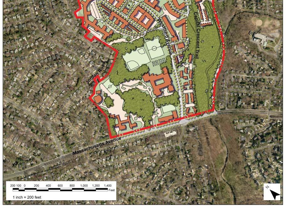
9 November 18 Concept Framework Plan Concept Framework Plan Concept Framework Plan with alternate Streets


10 November 18 Concept Framework Plan Heights New Streets and Civic Buildings


11 November 18 Concept Framework Plan Open Spaces and Trails Land Uses

12 November 18 Concept Framework Plan

13 November 18 Concept Framework Plan

14 November 18 Concept Framework Plan

15 November 18 Concept Framework Plan

16 November 18 Concept Framework Plan River Road/Metropolitan Branch Trail Crosswalks, new sidewalks, on street bikeways, street trees, and consolidated driveways
17 November 18 Concept Framework Plan River Road/Metropolitan Branch Trail Urban Boulevard with new crosswalks, new sidewalks, on street bikeways, street trees, and consolidated driveways M NCPPC Montgomery County Planning Department montgomeryplanning.org
18 November 18 Concept Framework Plan Preliminary Residential Yields: Existing Holding Capacity Proposed Housing Units:

19 November 18 Concept Framework Plan
Hennepin Avenue Downtown
 Hennepin Avenue Downtown Construction Kick-off Meeting Stakeholders, Owners, Managers January 14 & 17, 2019 Agenda Summary Background Principles Scope, Schedule, Budget Construction Utilities Roadway What
Study Area and Location District PSA Ward ANC Phase Description B Planned Branch Avenue Northbound at Alabama Avenue Southeast
 Speed Limit and Safety Nexus Studies for Automated Enforcement Locations in the District of Columbia Branch Avenue at Alabama Avenue SE Study Area and Location District PSA Ward ANC Phase Description 6
Speed Limit and Safety Nexus Studies for Automated Enforcement Locations in the District of Columbia 1100 Block 4th Street NE
 Speed Limit and Safety Nexus Studies for Automated Enforcement Locations in the District of Columbia 11 Block 4th Street NE Study Area and Location District PSA Ward ANC Phase Description 1 14 6 6C Proposed
Study Area and Location District PSA Ward ANC Phase Description C Existing 3500 Block Massachusetts Avenue Northwest Eastbound
 Speed Limit and Safety Nexus Studies for Automated Enforcement Locations in the District of Columbia 35 Block Massachusetts Avenue NW Study Area and Location District PSA Ward ANC Phase Description 2 24
Reston Town Center North Development. Community Update
 Reston Town Center North Development Community Update May 31, 2017 1 Presentation Agenda Project Overview Site and Current Property Ownerships Development Plan/Grid of Streets Proposed Ownership Comprehensive
Adopted by La Mesa City Council July 9, 2013 Resolution
 Adopted by La Mesa City Council July 9, 2013 Resolution 2013-059 Table of Contents ACKNOWLEDGEMENTS... A-1 INTRODUCTION... I-1 Vision... I-1 Background... I-1 Citizen Participation... I-3 Planning in La
SITE DESCRIPTION. Vicinity
 SITE DESCRIPTION Vicinity The Montrose Shopping Center is located in the northeast quadrant of the intersection of Randolph Road and Rockville Pike (MD 355). The existing building (formally known as the
Study Area and Location District PSA Ward ANC Phase Description A Existing 1700 Block North Portal Drive Northwest Southwest-bound
 Speed Limit and Safety Nexus Studies for Automated Enforcement Locations in the District of Columbia 17 Block North Portal Drive NW Study Area and Location District PSA Ward ANC Phase Description 4 41
Study Area and Location District PSA Ward ANC Phase Description D Proposed 1900 Block Foxhall Road Northwest Southbound
 Speed Limit and Safety Nexus Studies for Automated Enforcement Locations in the District of Columbia 19 Block Foxhall Road NW S/B Study Area and Location District PSA Ward ANC Phase Description 2 25 3
Site 17 W3-160 KEY: District Department of Transportation 55 M Street, SE, Suite 400 Washington, DC 20003
 Speed Limit and Safety Nexus Studies for Automated Enforcement Locations in the District of Columbia Connecticut Avenue at Calvert Street NW Study Area and Location District PSA Ward ANC Phase Description
FORM-BASED CODES IN THE WEST. Rocky Mountain Land Use Institute March 2007
 FORM-BASED CODES IN THE WEST Rocky Mountain Land Use Institute March 2007 Speakers Matt Goebel, AICP, Clarion Associates Background: What s a form-based code? Recent examples from the western US. Brewster
vision42
 vision42 www.vision42.org vision4 auto-free light rail 2 boulevard for 42nd Street Roxanne Warren, AIA, Chair George Haikalis, ASCE, Co-Chair Institute for Rational Urban Mobility,Inc. www.vision42.org
Council of State Governments. Takoma Langley Transit Center Purple Line Project Briefing. October 28, 2013
 Council of State Governments Takoma Langley Transit Center Purple Line Project Briefing October 28, 2013 Takoma Langley Transit Center Purpose and Need Provide a safe, attractive and efficient facility
Integrating Travel Demand Management into the Long-Range Planning Process 2017 AMPO
 Integrating Travel Demand Management into the Long-Range Planning Process 2017 AMPO October 19, 2017 Chattanooga 2045 RTP Chattanooga 2045 RTP addresses both transportation supply and demand Continued
ARLINGTON COUNTY, VIRGINIA
 ARLINGTON COUNTY, VIRGINIA County Board Agenda Item Meeting of December 12, 2015 DATE: December 1, 2015 SUBJECT: SP-84-U-15-1 USE PERMIT ASSOCIATED WITH A SITE PLAN for a telecommunications facility; located
Study Area and Location District PSA Ward ANC Phase Description G Planned Connecticut Avenue Northbound at Military Road Northwest
 Speed Limit and Safety Nexus Studies for Automated Enforcement Locations in the District of Columbia Connecticut Avenue at Military Road NW Study Area and Location District PSA Ward ANC Phase Description
Speed Limit and Safety Nexus Studies for Automated Enforcement Locations in the District of Columbia East Capitol Street at Southern Avenue NE
 Speed Limit and Safety Nexus Studies for Automated Enforcement Locations in the District of Columbia East Capitol Street at Southern Avenue NE Study Area and Location District PSA Ward ANC Phase Description
Site 40. Recreational Center
 Speed Limit and Safety Nexus Studies for Automated Enforcement Locations in the District of Columbia Georgia Avenue S/B at Missouri Avenue NW Study Area and Location District PSA Ward ANC Phase Description
Study Area and Location District PSA Ward ANC Phase Description A Proposed 6100 Block Georgia Avenue Northwest Southbound
 Speed Limit and Safety Nexus Studies for Automated Enforcement Locations in the District of Columbia 6100 Block Georgia Avenue NW Study Area and Location District PSA Ward ANC Phase Description 4 402 4
Study Area and Location District PSA Ward ANC Phase Description G Proposed 2900 Block Military Road Northwest Eastbound
 Speed Limit and Safety Nexus Studies for Automated Enforcement Locations in the District of Columbia 29 Block Military Road NW E/B Study Area and Location District PSA Ward ANC Phase Description 2 21 3
TRANSIT CENTER DISTRICT PLAN
 TRANSIT CENTER DISTRICT PLAN Informational Presentation Planning Commission 04.19.2012 San Francisco Planning Department In partnership with: San Francisco Redevelopment Agency Transbay Joint Powers Authority
Regional Centers Framework Update. Regional Project Evaluation Committee March 24, 2017
 Regional Centers Framework Update Regional Project Evaluation Committee March 24, 2017 Overview Background Project Overview and Previous Board Direction Overview of Stakeholder Working Group Report Process
Proposed FY 06 Project Development Program and FY 05 Project Development Program Update
 Washington Metropolitan Area Transit Authority Proposed FY 06 Project Development Program and FY 05 Project Development Program Update Presented to the Board of Directors: P D E C Planning & Development
GATEWAY. Action Plan JULY Gateway Action Plan DRAFT - July Portland Development Commission
 GATEWAY Action Plan JULY 2016 1 Gateway Action Plan DRAFT - July 2016 - Portland Development Commission INTRODUCTION: The City of Portland, the Portland Development Commission (PDC), and their many partners
Port of Vancouver USA
 Port of Vancouver USA AAPA Port Real Estate Issues Workshop SEPTEMBER 18, 2018 SEATTLE, WA MIKE SCHILLER, DIRECTOR BUSINESS DEVELOPMENT PORT OF VANCOUVER USA 800 acres of operating port 600 acres of future
The Blue Line Extension
 The Blue Line Extension NORTH CAROLINA JOINT TRANSPORTATION OVERSIGHT COMMITTEE Presented by Carolyn Flowers CATS Chief Executive Officer Raleigh, NC February 10, 2012 Overview Charlotte Area Transit System
Corridor Management Committee Meeting. June 4, 2014
 Corridor Management Committee Meeting June 4, 2014 1 Today s Topics Welcome Approval of Minutes Municipal Consent Process Update Public Hearing Schedule City/County Comment Categories Public Outreach Activities
Facilities Strategic Planning. Community Centers Stakeholder Group October 16, 2017 Jeanne Justice
 Facilities Strategic Planning Community Centers Stakeholder Group October 16, 2017 Jeanne Justice Agenda Review facilities prioritization criteria Co-location examples Co-location exercise Coming Up: 10/17
ARLINGTON COUNTY, VIRGINIA
 ARLINGTON COUNTY, VIRGINIA County Board Agenda Item Meeting of May 20, 2017 DATE: May 10, 2017 SUBJECT: SP-339-U-17-2 USE PERMIT ASSOCIATED WITH A SITE PLAN for a telecommunications facility at Clarendon
Traffic Impact Study for the TAVA Homes Project at 1584 East Santa Clara Avenue in the City of Santa Ana
 Traffic Impact Study for the TAVA Homes Project at 1584 East Santa Clara Avenue in the City of Santa Ana March 2011 Prepared for: URS Corporation 2020 E. First Street, Suite #400 Santa Ana, CA 92705 Tel:
Anchorage Land Use Plan Map Update Vision
 Anchorage Land Use Plan Map Update Vision Carol Wong Manger, Tom Davis Project Manager and many others working hard to listen to the community. Hal Hart AICP Planning Director May 9 th 2017 1 Vision: the
Redevelopment Agency of Midvale City
 Redevelopment Agency of Midvale City 2013 Annual Report The 2013 Annual Report for the Redevelopment Agency of Midvale City is submitted herewith. Utah State Law requires Community Renewal Agencies submit
Dakota County Transportation CIP Process Requests from cities/townships
 City of Apple Valley Letter: e-mail w/traffic Engineer City of Apple Valley Engineer coordinating CIP Project County Traffic Staff is in the process of assessing Requests directly with Dakota County Traffic
Form-Based Codes: The Basics. Jorge E. Rousselin COA Planning and Development Review Urban Design
 Form-Based Codes: The Basics Jorge E. Rousselin COA Planning and Development Review Urban Design Form Based Codes: The Basics Purpose of tonight s presentation 1. What is a Form Based Code (FBC)? 2. What
St. Helena Island 5-6 December,
 5-6 December, 2011 Beaufort County Multi-Jurisdictional Form-Based Code Workshop and Charrette Report 2011 Opticos Design, Inc. 154 Beaufort County Multi-Jurisdictional Form-Based Code Workshop and Charrette
Unified Development Code. Public Workshop No. 3 November 7, 2017
 Unified Development Code Public Workshop No. 3 November 7, 2017 Purpose of the Project 2 The overall goal of the project is to bring together the County s Land Development Regulations (Chapter 74 of the
Crystal Springs Upland School Transportation Demand Management Plan. March 2016
 Crystal Springs Upland School Transportation Demand Management Plan March 06 CONTENTS Introduction... Transportation Demand Management (TDM) Program.... Background/Survey of Existing Student Commuting
CodeNEXT Overview August 19, Code Development Team
 CodeNEXT Overview August 19, 2016 Code Development Team Imagine Austin Policy 2 Imagine Austin Policy Direction A City of Complete Communities 3 Imagine Austin Policy Direction One implementation tool
26 th Street North and Old Dominion Drive Master Planning Task Force
 26 th Street North and Old Dominion Drive Master Planning Task Force Presentation to Arlington Joint Facilities Advisory Commission October 24, 2018 Site Master Planning Task Force On September 2018, the
INDUSTRIAL LAND FOR SALE
 INDUSTRIAL LAND FOR SALE INDUSTRIAL LAND & DEVELOPMENT OPPORTUNITIES 150 ACRE INDUSTRIAL BUSINESS PARK LOTS RANGING FROM 5 150 ACRES Property Features Nexus at DIA provides a compelling opportunity for
Adopt a resolution (Attachment 16) approving amendments to the North 40 Specific Plan.
 approving amendments to the North 40 Specific Plan.") TOWN OF LOS GATOS COUNCIL AGENDA REPORT MEETING DATE: 1/16/2018 ITEM NO: 14 DATE: TO: FROM: MAYOR AND TOWN COUNCIL LAUREL PREVETTI, TOWN MANAGER SUBJECT: ADOPT A RESOLUTION APPROVING AMENDMENTS TO THE
TOWN OF LOS GATOS COUNCIL AGENDA REPORT MEETING DATE: 1/16/2018 ITEM NO: 14 DATE: TO: FROM: MAYOR AND TOWN COUNCIL LAUREL PREVETTI, TOWN MANAGER SUBJECT: ADOPT A RESOLUTION APPROVING AMENDMENTS TO THE
City Avenue District. City Avenue Rezoning Workshop January 25, :30 p.m. Board of Commissioners
 City Avenue District City Avenue Rezoning Workshop January 25, 2011 6:30 p.m. Board of Commissioners Meeting Agenda Approval process and status of ordinance Amendments to the Regional Center Area Applicability
ARLINGTON COUNTY, VIRGINIA. County Board Agenda Item Meeting of January 28, 2017
 ARLINGTON COUNTY, VIRGINIA County Board Agenda Item Meeting of January 28, 2017 DATE: January 7, 2017 SUBJECT: U-3473-16-1 USE PERMIT for a telecommunications facility on the rooftop of Heather Apartments;
AGREEMENT FOR 520 SECTOR PLAN ADDENDUM 2: ADDITIONAL SERVICE CODE STREAMLINING PROJECT
 AGREEMENT FOR 520 SECTOR PLAN ADDENDUM 2: ADDITIONAL SERVICE CODE STREAMLINING PROJECT THIS Addendum 2 (this Addendum ) made and entered into this date, 2015 supplements the Contract (the Contract ) made
GORE BUILDING. 238 N. Massachusetts Avenue, Lakeland, FL 33801
 GORE BUILDING 238 N. Massachusetts Avenue, Lakeland, FL 33801 CDB LOCATION REDEVELOPMENT PROJECT MUNN PARK HISTORIC DISTRICT INCENTIVES AVAILABLE ADJACENT PARKING INCLUDED BK698301 Phone: (863) 683-3425
Site 59 W5-147 KEY: District Department of Transportation 55 M Street, SE, Suite 400 Washington, DC 20003
 Speed Limit and Safety Nexus Studies for Automated Enforcement Locations in the District of Columbia 11 Block Bladensburg Road NE SW/B Study Area and Location District PSA Ward ANC Phase Description 5
CITY OF KIRKLAND TRAFFIC IMPACT ANALYSIS GUIDELINES
 CITY OF KIRKLAND TRAFFIC IMPACT ANALYSIS GUIDELINES SEPA TRANSPORTATION CONCURRENCY - ROAD IMPACT FEES Introduction Revised February 2004 These guidelines describe how to prepare a traffic study, or Traffic
REVIEW OF REGIONAL GROWTH CENTER APPLICATION
 REGIONAL DESIGNATION RECOMMENDATION REPORT REVIEW OF REGIONAL GROWTH CENTER APPLICATION CITY OF ISSAQUAH MARCH 18, 2015 OVERVIEW On January 30, 2015, PSRC staff received an application from the City of
COMMERCIAL SITE AT GENERATION PARK
 COMMERCIAL SITE AT GENERATION PARK 77.9 Acre Site on Lockwood Road Generation Park Location Map Close Proximity to Major Destinations & Transportation Corridors Generation Park Features 4,000-acre master-planned
MARTA Transit Oriented Development Update Regional Transit Committee Thursday, May 14, 2015
 MARTA Transit Oriented Development Update Regional Transit Committee Thursday, May 14, 2015 1 Transit Oriented Development (TOD) Goals Transit-oriented development, or TOD, means development that is vibrant,
Environmental Impact Questionnaire
 Community Development Department 11 English Street Petaluma, CA 94952 Phone: 707-778-4301 Email: cdd@ci.petaluma.ca.us Web: www.cityofpetaluma.net/cdd Building Geographic Information Systems Housing Neighborhood
Opera Customer Information System Guide. Version 2.0 January 2011
 Opera Customer Information System Guide Version 2.0 January 2011 Contents Opera Customer Information System: What is it?... 2 Using the Lookup Feature... 2 Information on the Profile Screen... 4 Central
Downtown to NAIT LRT Concept Plan Attachment 4 Public Involvement Summary
 north, lrt, light, transit, rail, track, line, closure, close, road, interuption, partial, lane, construction, bulletin, NAIT, line, motorist, pedestrian, map, metro, line,downtown to NAIT LRT Concept
Review of Cartographic Data Types and Data Models
 Review of Cartographic Data Types and Data Models GIS Data Models Raster Versus Vector in GIS Analysis Fundamental element used to represent spatial features: Raster: pixel or grid cell. Vector: x,y coordinate
CITY PLANNING COMMISSION AGENDA ITEM NO: 6 STAFF: CARL SCHEULER FILE NO: CPC CA LEGISLATIVE
 Page 61 CITY PLANNING COMMISSION AGENDA ITEM NO: 6 STAFF: CARL SCHEULER FILE NO: CPC CA 09-00009 LEGISLATIVE PROJECT: ADDING NEW PART 8 TO CHAPTER 7, ARTICLE 3 OF THE ZONING CODE (SECTIONS 7.3.801-814)
Downtown Boise Multimodal Center
 Treasure Valley High Capacity Transit Study Downtown Boise Multimodal Center Environmental Assessment June 2009 Prepared by the Federal Transit Administration and Valley Regional Transit. U.S. Department
AGENDA ITEM # 1. CITY COUNCIL COMMUNICATION FORM
 AGENDA ITEM # 1. CITY COUNCIL COMMUNICATION FORM FROM: Joel Rae, Director of Public Safety (ext. 113) THROUGH: Deb Hinsvark, Interim City Manager (ext. 228) DATE: December 18, 2012 RE: Police and Fire
// Atlanta BeltLine Quarterly Briefing
 // Atlanta BeltLine Quarterly Briefing Second Quarter // May 15, 2014 5/20/2014 Atlanta BeltLine // 2014 Page 1 // Agenda Welcome Atlanta BeltLine, Inc. Update Parks, Trails, Transit Art on the Atlanta
Standish Corner Village. The Future Village: By Choice or By Chance? Today
 Standish Corner Village Lessons Learned Workshops The Future Village: By Choice or By Chance? Project Background Today The Role & Importance of Visioning Civic Engagement Implementation Tools & Techniques
Speed Limit and Safety Nexus Studies for Automated Enforcement Locations in the District of Columbia DC Miles South of Pennsylvania Avenue SE
 Speed Limit and Safety Nexus Studies for Automated Enforcement Locations in the District of Columbia DC 295.4 Miles South of Pennsylvania Avenue SE Study Area and Location District PSA Ward ANC Phase Description
STATE OF THE ATLANTA BELTLINE 22 Miles to A Better Atlanta May 25, 2016
 STATE OF THE ATLANTA BELTLINE 22 Miles to A Better Atlanta May 25, 2016 STATE OF THE ATLANTA BELTLINE 22 Miles to A Better Atlanta MICHAEL PARIS President & CEO Council for Quality Growth STATE OF THE
CREATING CRITICAL MASS IN THE URBAN CORE
 CREATING CRITICAL MASS IN THE URBAN CORE MICHAEL BALANKY, PRINCIPAL What is Critical Mass In real estate dynamics, critical mass happens when the rate of development becomes selfsustaining and creates
Traffic Impact Analysis
 LA PALMA VILLAGE INITIAL STUDY CITY OF ANAHEIM Appendices Appendix I Traffic Impact Analysis September 2015 LA PALMA VILLAGE INITIAL STUDY CITY OF ANAHEIM Appendices This page intentionally left blank.
Record of Public Comment on Central Corridor SDEIS
 Executive Summary Page 1 Executive Summary Project Background The Ramsey County Regional Rail Authority (RCRRA) initiated the Central Corridor scoping process in 2001 and conducted the Alternatives Analysis
Final Presentation SUITLAND FEDERAL CENTER. SUITLAND FEDERAL CENTER MASTER PLANNING ULI minitap
 Final Presentation SUITLAND MASTER PLANNING ULI minitap GENERAL SERVICES ADMINISTRATION NATIONAL CAPITAL REGION OFFICE OF PLANNING & DESIGN QUALITY 7TH & D STREETS SW WASHINGTON, DC 20407 2:30 4:00 PM
2014 BOND PROGRAM UPDATE
 2014 BOND PROGRAM UPDATE Presented to the City Council By the City Manager s Office August 11, 2015 1 Topics Previous Debt Programs 2014 Bond Program o Goals o Funding Commitments o Progress Communication
Appendix D Supportive Transportation Materials
 Appendix D Supportive Transportation Materials D.1. Stakeholder Input and Coordination As noted in Section 1.7 of the main Master Plan document, there have been several opportunities for stakeholders to
Electric Load Growth Q2 Update. Chad Rissman- Director of Engineering and Asset Management & Andy Wendell Director of Customer Services April,
 Electric Load Growth Q2 Update Chad Rissman- Director of Engineering and Asset Management & Andy Wendell Director of Customer Services April, 2 2018 1 Updates Informational, no action required Discussions
GIS Change Requests: Web Base change requests will replace MSAG Update paper form.
 GIS Change Requests: Web Base change requests will replace MSAG Update paper form. Types of edits that will need to be reported Individual address edits (move, delete, add or change) Road edits (add, delete,
Redmond Facilities Strategic Management Plan Overview
 Redmond Facilities Strategic Management Plan Overview Project Purpose + Provide guidance on how to best operate, maintain, and upgrade facilities now and in the future + Optimize maintenance staffing and
6500 Harry Hines Boulevard Dallas, TX 75235
 CoStar-41051 LoopNet- 17906172 Xceligent -1379536 6500 Harry Hines Boulevard Dallas, TX 75235 Dallas Medical District Unique Site 5.31 Acres 81,000 + SF Offices Offered Exclusively by JacksonCooksey For
Peoria County Front Desk Map Application
 Peoria County Front Desk Map Application Quick Guide, 2017 At a First Glance This guide will tell users all they need to know about the Peoria County Front Desk application which can be found on the Peoria
BC OnLine. Site Registry User s Guide. Last Updated June 11, 2014
 BC OnLine Site Registry User s Guide Last Updated June 11, 2014 Copyright Copyright 2014 Province of British Columbia. All rights reserved. This user s guide is for users of the BC OnLine services who
Next Steps. Investing in the Future of. MASTER DEVELOPER PROCUREMENT OVERVIEW October 2016 July Chicago Union Station Chicago Union Station
 Investing in the Future of Chicago Union Station Chicago Union Station MASTER DEVELOPER PROCUREMENT OVERVIEW October 2016 July 2015 Next Steps 1 Chicago Union Station Operations 4 th busiest station in
Municipal Service Park 3 December Consolidation of City services to one centralized complex
 Municipal Service Park 3 December 2010 Consolidation of City services to one centralized complex Overview: Operational Challenges and Opportunities South East Connector impacts Opportunities: The South
November 28, 2012 ALTERNATIVES ANALYSIS PUBLIC MEETING
 November 28, 2012 ALTERNATIVES ANALYSIS PUBLIC MEETING Project Background Description of the Project Alternatives Analysis Process Project Progress Activity Stations Comments Adjourn 2 VIA spent 2 years
South Mountain Freeway Interchange Selection
 slide 1 South Mountain Freeway Interchange Selection Public Private Partnership (P3) Today s Agenda Project Overview Interchange Selection Pavement Selection Lawsuit Update Design and Construction Q&A
APPENDIX A TDM Development Guideline
 Appendix A: TDM Development Guideline APPENDIX A TDM Development Guideline Appendix A: TDM Development Guideline Page A.1 1 INTRODUCTION AND OVERVIEW 1.1 About This Guideline This guideline contains information
ARLINGTON COUNTY, VIRGINIA
 ARLINGTON COUNTY, VIRGINIA County Board Agenda Item Meeting of July 19, 2008 DATE: July 11, 2008 SUBJECT: SP#125 SITE PLAN AMENDMENT for proposed conversion of retail and conference space to cable television
Research Guide. Using Sanborn Maps
 Research Guide Using Sanborn Maps Prepared by: Ralph B. Taylor Date of last revision: 11/26/2007 Research Guide: Using Sanborn Maps 1 Background Sanborn Maps were used by planners, prior to the advent
Western Illinois University Quad Cities Facilities. Consolidated Fiscal-Year 2012 Annual Report and Fiscal-Year 2013 Planning Document
 Mission statement: Western Illinois University Quad Cities Facilities Consolidated Fiscal-Year 2012 Annual Report and Fiscal-Year 2013 Planning Document Submitted by: William Brewer University Architect
City Council Report 915 I Street, 1 st Floor
 Meeting Date: 6/16/2015 Report Type: Consent Report ID: 2015-00512 04 City Council Report 915 I Street, 1 st Floor www.cityofsacramento.org Title: Capital Improvement Program: Central City Lighting (T15155200)
MARINA PARK PUBLIC ART AT FLAG PLAZA
 CONTEXTUAL OVERVIEW STANLEY PARK COAL HARBOUR HARBOUR GREEN PARK DEVONIAN HARBOUR PARK COAL HARBOUR COMMUNITY CENTRE & PARK CARDERO PARK MARINA PARK 10 MINUTE WALK 5 MINUTE WALK LOST LAGOON PUBLIC ART
Applications & Conversion Requests in the Study Area (North side of Dupont Street: Ossington Avenue - Kendal Avenue)
") Applications & Conversion Requests in the Study Area (North side of Dupont Street: Ossington Avenue - Kendal Avenue) Applications 1. 328-374 Dupont Street (Annex Centre) - Official Plan Amendment 2. 840-860
Applications & Conversion Requests in the Study Area (North side of Dupont Street: Ossington Avenue - Kendal Avenue) Applications 1. 328-374 Dupont Street (Annex Centre) - Official Plan Amendment 2. 840-860
North Metro Corridor Draft Environmental Impact Statement (DEIS) Public Hearings. December 9 & 10, 2009
 Public Hearings. December 9 & 10, 2009") North Metro Corridor Draft Environmental Impact Statement (DEIS) Public Hearings December 9 & 10, 2009 1 Welcome & Introductions 2 3 What Are We Doing Here Tonight? Public Hearing for RTD North Metro Corridor
North Metro Corridor Draft Environmental Impact Statement (DEIS) Public Hearings December 9 & 10, 2009 1 Welcome & Introductions 2 3 What Are We Doing Here Tonight? Public Hearing for RTD North Metro Corridor
Delivering faster broadband, further...
 Delivering faster broadband, further... Broadband technology solutions for existing NETWORK INFRASTRUCTURES Page 1 Address the challenge of delivering more for less Delivering faster broadband, further
Study Area and Location District PSA Ward ANC Phase Description A Proposed I-395 Southwest after Exit 4, Eastbound
 Speed Limit and Safety Nexus Studies for Automated Enforcement Locations in the District of Columbia I-395 SW after Exit 4 E/B Study Area and Location District PSA Ward ANC Phase Description 1 71 8 8A
Welcome to the 2009 General Assembly
 Welcome to the 2009 General Assembly Development Excellence : Illustrated Issues Facing the Region Transportation Air Quality Water Supply Environment Mission Statement: Center of Development Excellence
WIRELESS BROADBAND Supplemental Broadband Solution
 WIRELESS BROADBAND Supplemental Broadband Solution Our Public Power: The Next Generation April 3, 2017 NO BOARD ACTION REQUESTED WHY ARE WE HERE? Follow-up on our 2015 Strategic Planning recommendation
ROCKSIDE WOODS BLVD. INDEPENDENCE, OHIO 44131
 DEVELOPMENT DEVELOPMENT SUMMARY: Available for Sale along Rockside Woods Blvd. and Brecksville Road (Route 21) are (7) seven development ready sites. These sites can serves a variety of uses including
ARLINGTON COUNTY, VIRGINIA. County Board Agenda Item Meeting of April 22, 2017
 ARLINGTON COUNTY, VIRGINIA County Board Agenda Item Meeting of April 22, 2017 DATE: April 10, 2017 SUBJECT: U-3481-17-1 USE PERMIT for a telecommunications facility located at 1200 Fort Myer Drive (RPC#
ONCOR INFRASTRUCTURE DEVELOPMENT
 ONCOR INFRASTRUCTURE DEVELOPMENT Ellen Buck Presentation to Leadership North Texas March 27, 2015 ONCOR: 100 YEARS AND COUNTING Largest Texas regulated utility More than 3,000 employees 10 million living
Telecommunications Update 2/8/2017
 Telecommunications Update 2/8/2017 Telecommunications Overview Grants Awarded $900K DOLA grant for Telecommunications infrastructure and Microwave backhaul (thanks go to Kara for leading the proposal effort).
DRAFT Capital Facilities and Infrastructure Technical Bulletin
 DRAFT Capital Facilities and Infrastructure Technical Bulletin This guidance is intended to clarify how the Capital Facilities and Infrastructure Goal and Objectives of the Regional Policy Plan (RPP) are
HISTORIC & FLEXIBLE POST INDUSTRIAL HEADQUARTERS
 Presented by : HISTORIC & FLEXIBLE POST INDUSTRIAL HEADQUARTERS Central Location \ Surrounded by Wicker Park, Bucktown, Lincoln Park, Old Town, River North, and River West. Unbeatable access to young,
ARLINGTON COUNTY, VIRGINIA. County Board Agenda Item Meeting of September 20, 2014
 ARLINGTON COUNTY, VIRGINIA County Board Agenda Item Meeting of September 20, 2014 DATE: September 8, 2014 SUBJECT: U-3340-12-1 USE PERMIT REVIEW of a 50' telecommunications pole with accompanying equipment
Version 14 COURSE UNIT 6. Visualisation
 Version 14 COURSE UNIT 6 Visualisation Table of Contents Introduction... 2 Preparation... 3 Materialization... 4 View position... 9 Camera... 10 Create design model view.... 12 Move background image...
NORTH SIDE IMPACT ANALYSIS
 NORTH SIDE IMPACT ANALYSIS INDOT INTERSTATE PROJECTSS Heavy investment in a fifty-year-old central Indiana interstate system is in process, and unless redirected, will incrementally embed the system s
Sundar Rajan, PMP
 Sundar Rajan, PMP Agenda: Overview of the tools and Apps marketplace in the Project Management Context Look at couple of tools in Project Portfolio Management and Application Lifecycle Management The new
The Practicalities of Form-Based Codes. (and How They re Being Applied in Albany)
") The Practicalities of Form-Based Codes (and How They re Being Applied in Albany) Victor Dover, FAICP Dover, Kohl & Partners Don Elliott, FAICP Clarion Associates The same and yet so different. 1 La Palma
The Practicalities of Form-Based Codes (and How They re Being Applied in Albany) Victor Dover, FAICP Dover, Kohl & Partners Don Elliott, FAICP Clarion Associates The same and yet so different. 1 La Palma