Creating Transparency, Openness and Trust: Modern Approach to Redistricting
|
|
|
- Herbert Morton
- 6 years ago
- Views:
Transcription
1 Creating Transparency, Openness and Trust: Modern Approach to Redistricting Richard Leadbeater, Esri Jerry Howe, Utah Legislature Larry Boden, Esri NCSL Legislative Summit Sunday, Aug. 6 11:15 am-12:15 pm


2 Insights Exploratory Analysis and Visualization Linked and Responsive Charts and Maps A New App Visual, Intuitive, Responsive Dynamic Spatial Analytics and Visualizations Very Fast Integrated Spatial and Tabular Analysis On-the-Fly Visual Models


3 ArcGIS Online ArcGIS Available as SaaS New and Improved Smart Mapping and 3D Analysis Tools Vector Tiles Credit Allocation Enhanced OGC Support Administration Social Logins UI/UX Coming Improved Search & Data Management Org-to-Org Collaboration Raster Analysis More Smart Mapping & 3D More Content Interactive Data Analysis 3.8 MILLION Users +30% Complete Cloud-Based Mapping Platform with Apps and Content ONE BILLION / Day Map Views 7.9 MILLION Items 18.8 MILLION Open Data Downloads +35% +40% +411%
4 ArcGIS Enterprise ArcGIS In Your Own Infrastructure Any Client Web Maps, Layers, and Scenes Portal REST Based Access Any Data Source Distributed Portal Abstracts and Organizes Any Data Type

5 GIS Provides the Platform For Managing, Analyzing, and Applying Geographic Information Integrating People, Processes, Things, and Data About Them Using the Power of Where to Integrate Everything


6 Web GIS Is the Modern GIS Architecture Helping Everyone Do Their Work Better Organizations Growing Exponentially Departments Teams Individuals Sharing Knowledge Leveraging Web Services Collaboration Improving Productivity and Efficiency
7 Product Vision Create a product line that solves election management and redistricting and territory design problems for the desktop, enterprise, and online users Establish an online community where users can collaborate and share their results Provide online access to standard data content used by this community (Census, Zip, Precincts, etc.) Provide online tools to manage and disseminate election data and results
8 Redistricting Online Increasing the collaboration between government and citizens Legislative Staff Legislators Advocacy Groups Create Edit Publish Review Collaborate Consultants Historic Election Files Consulting Data US Census P.L Data DOJ

9 Redistricting Online - Key Functional Components Plan Creation and Editing Census and Custom Geography Data Map Navigation Mash-ups Redlining Feature Selection Plan Publication and Sharing Data Export Printing Plan Integrity and Management Thematic Mapping
10 Web GIS Enables a Whole New Scale of GIS Interconnecting Systems and Expanding Collaboration Departments Organizations Teams System of Systems Individuals


11 Web GIS Enables Community Engagement Organizing and Managing Community Interactions Providing Citizens Information And Leaders Input Citizen Communication Citizen Surveys (Crowdsourcing) Status Reporting Community GIS Hub Open Data Storytelling Demographic Information Policy Initiative Based

12 REDISTRICT UTAH Online Public Redistricting Tool Prepared by Jerry Howe, Managing Policy Analyst, Office of Legislative Research and General Counsel NCSL 2017 Boston, Massachusetts
13 REDISTRICT UTAH the Legislature shall divide the state into congressional, legislative, and other districts Utah Constitution Article IX, Section 1
14 REDISTRICT UTAH Redistricting Committee 20 legislators appointed by President and Speaker Adopted principles and guidelines 28 meetings; including 17 public hearings across state
15 PRINCIPLES ADOPTED BY 2011 REDISTRICTING COMMITTEE Districts to be: Single Member; Contiguous; and Compact Acceptable Deviations: Congressional ± 0.1% Legislative ± 3.5% School Board ± 3.5%
16 PUBLIC PARTICIPATION ENCOURAGED: ONLINE TOOL DEVELOPED Contracted with ESRI to Create Online Tool Any Registered User May Submit a Plan Public Plans Required to Comply with Redistricting Principles - Single Member Districts - Compact and Contiguous - Meet Deviation Standards - Complete
17 REDISTRICT UTAH Staff used ArcGIS and autobound Public used an ESRI web-based redistricting tool
18 PUBLIC PARTICIPATION ENCOURAGED: ONLINE TOOL DEVELOPED ESRI Tool Permitted the Public to: Create Groups, Share, and Modify Plans prior to Submission; and Submit Public Plans to the Redistricting Committee for Discussion at Public Meetings

19 5 tabs assist users draw maps Each tab has a ribbon of tools and information
20 PUBLIC USE OF ESRI TOOL 323 Plans Submitted 198 Congress Plans 271 Met Criteria 1,000 Registered Users
21 PUBLIC PARTICIPATION BENEFICIAL Transparency Improved Public Relations Public Participation Reduced Criticism Public Participants Were Thoughtful and Knowledgeable A Universal Truth: Districts Drawn in Isolation are Easy, Complete Plans are Not

22 PUBLIC PARTICIPATION WAS SUCCESSFUL Citizen Plan Adopted! Headlines: - Lawmakers endorse citizen map for new school board boundaries - Lawmakers endorse Logan resident's map for school board boundaries
23 UNINTENDED CONSEQUENCES We did not anticipate the public s desire to: explain in writing the merits of their plans; and comment on other public plans.
24 ACCOMMODATE PUBLIC COMMENT In 2010, legislative leaders created a blog - Posted all redistricting plans (public and legislative) on web - Public comment and analysis was encouraged on all plans In 2020, Utah Will Improve Online Public Comment Options
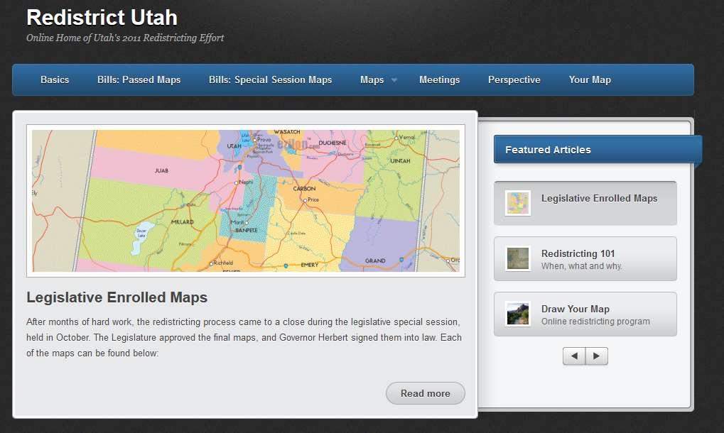
25 REDISTRICTUTAH.COM

26


27 What do you get with the Redistricting Solution? Software - ArcGIS Server - ArcView w/ Free Redistricting Add-On Data - ArcGIS Online Basemaps - ESRI Demographic Data - U.S. Census Data (2000, 2010 TIGER, PL ) - Optional Data Packs - ArcGIS Online Subscriber Content - ESRI Business & Demographic Data Nationwide - Custom Data (polling places, historical voting statistics, etc.) Deployment Support - ESRI Managed Services (24/7 infrastructure support and monitoring, high system availability, data management, etc.) - On Premise Deployment Consulting Resources - ArcGIS Online Resource Center (blogs, forums, downloads, etc.)
28 Redistricting Online - Key Functional Components Plan Creation and Editing Census and Custom Geography Data Map Navigation Mash-ups Redlining Feature Selection Plan Publication and Sharing Data Export Printing Plan Integrity and Management Thematic Mapping

29 Redistricting Online Deployment Options Software as a Service (SaaS) subscription model - Per user pricing - No custom features or data Managed Services Offering - Configured for organization - Custom data packs - All hosting components managed by ESRI On Premise Offering - Installed behind organizations firewall - Custom data packs - Hosting components managed by organization


30 Managed Services Deployment Infrastructure (In-House, Amazon) - Facilities - Network - Security - Hardware - Software Deployment - Staging - Production Data Management - Data Updates - Data Backup and Archive Technical Support and Monitoring - Tier 1 Helpdesk - Tier 2 Hosting Environment - Tier 3 Custom Application

31 Technology Stack Technologies for the desktop and web ArcGIS Desktop Authors ArcGIS Server 10 - Map Services ArcGIS Desktop 10 - Layer Packages Web Users GIS Users - Feature Services - Map Packages - Geometry Services ArcGIS Online Other Technologies - Online Base Maps - Adobe Flex - Geocoding Services - Amazon Cloud - Sharing & Discovery ArcGIS Online ArcGIS Servers Geodatabases
32 Solution Architecture Create & Publish Review & Comment on Plans Discover & Consume Services Standard Compactness Analysis Rich Web Clients Flash-capable Browser Redistricting Flex App ArcGIS Server Flex API Base Map Services ArcGIS Server Group Management Services Operational Layers Services Feature Data Services ArcGIS Server Geometry Service User Map Services User Data Layer Packages Map Packages Mash-ups Communities Map Caches ArcGIS.com User Data Plan Definitions Census Feature Data Tracts Block Groups Blocks Managed Services Desktop Redistricting Add-in ArcGIS Desktop ArcObjects.NET SDK Access Local Data Custom Compactness Analysis Author & Publish Content Discover & Consume Services

33
Advances in GIS help create Smarter Communities
 Advances in GIS help create Smarter Communities POP(ovich) Quiz Who is a Desktop User? Who is an ArcGIS Online User? Who is a ArcGIS Server Admin? Who is a Programmer? Who works with or for a government
ArcGIS Enterprise: Architecture & Deployment. Anthony Myers
 ArcGIS Enterprise: Architecture & Deployment Anthony Myers 1 2 3 4 5 Web GIS Overview of ArcGIS Enterprise Federation & Hosted Server Deployment Patterns Implementation 1 Web GIS ArcGIS Enabling GIS for
An Introduction to GIS for developers
 An Introduction to GIS for developers Part 4: GIS Sharing Canserina Kurnia & Tom Shippee Agenda Web GIS ArcGIS Online Cloud-based ArcGIS Server ArcGIS Server on-premises ArcGIS a complete platform discover,
ArcGIS Enterprise: An Introduction. Philip Heede
 Enterprise: An Introduction Philip Heede Online Enterprise Hosted by Esri (SaaS) - Upgraded automatically (by Esri) - Esri controls SLA Core Web GIS functionality (Apps, visualization, smart mapping, analysis
ArcGIS Enterprise: Portal Administration BILL MAJOR CRAIG CLEVELAND
 ArcGIS Enterprise: Portal Administration BILL MAJOR CRAIG CLEVELAND Agenda Welcome & Introduction to ArcGIS Enterprise Portal for ArcGIS - Basic Configuration - Advanced Configuration - Deploying Apps
ArcGIS Online. The Road Ahead Geoff Mortson
 ArcGIS Online The Road Ahead Geoff Mortson gmortson@esricanada.com ArcGIS Online Easily create and share maps Delivered as intelligent maps Access on virtually any device anyone, anywhere Compliments and
ArcGIS Enterprise: An Introduction. David Thom Solution Engineer State Government
 ArcGIS Enterprise: An Introduction David Thom Solution Engineer State Government What is ArcGIS Enterprise? ArcGIS Enterprise is server software that allows you to use infrastructure you manage to implement
Configuring ArcGIS Enterprise in Disconnected Environments
 Configuring ArcGIS Enterprise in Disconnected Environments BILL MAJOR Disconnected Environments Not everyone has internet access? How many of you run disconnected today, i.e. no internet access? Many customers
Administering Your ArcGIS Enterprise Portal Bill Major Craig Cleveland
 Administering Your ArcGIS Enterprise Portal Bill Major Craig Cleveland Agenda Welcome & Introduction to ArcGIS Enterprise Portal for ArcGIS Administration - Basic Configuration - Advanced Configuration
ICIT. Brian Hiller ESRI Account Manger. What s new in ArcGIS 10
 ICIT Brian Hiller ESRI Account Manger What s new in ArcGIS 10 ArcGIS 10 Fast Easy Powerful Everywhere late June 2010 ArcGIS System for Geographic Information Desktop Server Mobile Online A System A Complete
ArcGIS Online: Best Practices for High-Demand Web Applications. Kelly Gerrow-Wilcox Bonnie Stayer Beth Romero
 ArcGIS Online: Best Practices for High-Demand Web Applications Kelly Gerrow-Wilcox Bonnie Stayer Beth Romero Agenda Communicating with Maps Who do you build your apps for? Layer Types Scalability and Response
Working with the ArcGIS Viewer for Flex Application Builder
 Working with the ArcGIS Viewer for Flex Application Builder Esri Canada User Conference St. John s November 15, 2012 Presented By: Greg Yetman gyetman@esri.ca Agenda This seminar is designed to help you
Extend GIS. The Reach. Of Your GIS. Chris Cappelli Nathan Bennett
 Extend The Reach GIS Of Your GIS Chris Cappelli Nathan Bennett Where do your co-workers, managers, customers, and citizens go when they want to find or make a map? GIS is a practical system for problem
ArcGIS for Server Administration. Andrew Sakowicz
 ArcGIS for Server Administration Andrew Sakowicz asakowicz@esri.com Target audience Administrators (GIS, DBA, System) Architects Developers Level: Intermediate Outline Key administrative functions Configuring
ArcGIS in the Cloud. Andrew Sakowicz & Alec Walker
 ArcGIS in the Cloud Andrew Sakowicz & Alec Walker Key Takeaways How to Identify Organizational Strategy & Priorities Esri s Cloud Offerings A Broad Spectrum Successfully Executing Your Strategy The Cloud
ArcGIS Online A Security, Privacy, and Compliance Overview. Andrea Rosso Michael Young
 ArcGIS Online A Security, Privacy, and Compliance Overview Andrea Rosso Michael Young ArcGIS Online A Multi-Tenant System Portal Portal Portal ArcGIS Online Agenda Online Platform Security Deployment Architecture
Getting Started with ArcGIS for Server. Charmel Menzel and Ken Gorton
 Getting Started with ArcGIS for Server Charmel Menzel and Ken Gorton Agenda What is ArcGIS for Server? Types of Web services Publishing resources onto the Web Clients to ArcGIS for Server Editions and
What s s Coming in ArcGIS 10 Desktop
 What s s Coming in ArcGIS 10 Desktop Damian Spangrud ArcGIS Product Manager, ESRI dspangrud@esri.com (or at least turn to silent) ArcGIS 10 A Simple & Pervasive System for Using Maps & Geographic Information
Intelligent Enterprise meets Science of Where. Anand Raisinghani Head Platform & Data Management SAP India 10 September, 2018
 Intelligent Enterprise meets Science of Where Anand Raisinghani Head Platform & Data Management SAP India 10 September, 2018 Value The Esri & SAP journey Customer Impact Innovation Track Record Customer
Texas Legislative Council
 Texas Legislative Council Clare Dyer, Manager, Mapping & Redistricting Ed Clow, GISP, Programmer Analyst, Applications Marshall Kunze, Programmer, Applications Texas Redistricting 2011 Time frame for Texas
Product-Specific Terms of Use
 Product-Specific Terms of Use SOFTWARE The following list identifies additional terms of use that apply to specific SoftwareProducts. Each Product listing identifies one or more footnotes that apply to
ArcGIS Hub: Open data best practices. Graham Hudgins, esri product engineer
 ArcGIS Hub: Open data best practices Graham Hudgins, esri product engineer Agenda Overview of open data in the ArcGIS Hub Example sites - Hubs Around the World Storymap Making a good site map Preparing
What s New in ArcGIS 10.3 for Server. Tom Shippee Esri Training Services
 What s New in ArcGIS 10.3 for Server Tom Shippee Esri Training Services Today s Agenda What is ArcGIS for Server at 10.3 - ArcGIS Platform story - Expanding ArcGIS for Server paradigm What s new in ArcGIS
Software and Migration Services FAQ for more information (available from Electronic Data Solutions ). Some implementation will be required, including
. Some implementation will be required, including") Sales and Marketing What is the target audience for FieldSeeker GIS for Mosquito Control? It is hoped that FieldSeeker GIS for Mosquito Control will serve the needs of small, medium, and large enterprise
Sales and Marketing What is the target audience for FieldSeeker GIS for Mosquito Control? It is hoped that FieldSeeker GIS for Mosquito Control will serve the needs of small, medium, and large enterprise
3D in the ArcGIS Platform. Chris Andrews
 3D in the ArcGIS Platform Chris Andrews Geospatial 3D is already all around us 3D is expanding the GIS community s opportunity to provide value 3D City & Infrastructure Models Generated 3D features Photogrammetrc
ArcGIS Enterprise Portal for ArcGIS
 Portal for ArcGIS Elzbieta Covington Outline This presentation is an overview of the components of ArcGIS Enterprise, including Installation Architecture Deployment 1 ArcGIS Online Both systems are complementary
IMAGERY FOR ARCGIS. Manage and Understand Your Imagery. Credit: Image courtesy of DigitalGlobe
 IMAGERY FOR ARCGIS Manage and Understand Your Imagery Credit: Image courtesy of DigitalGlobe 2 ARCGIS IS AN IMAGERY PLATFORM Empowering you to make informed decisions from imagery and remotely sensed data
Sharing Web Layers and Services in the ArcGIS Platform. Melanie Summers and Ty Fitzpatrick
 Sharing Web Layers and Services in the Platform Melanie Summers and Ty Fitzpatrick Agenda Platform overview - Web GIS information model - Two deployment options Pro Sharing - User experience and workflows
Using Collector for ArcGIS and Operations Dashboard for ArcGIS. Mike Sweeney Esri-Charlotte
 Using Collector for ArcGIS and Operations Dashboard for ArcGIS Mike Sweeney Esri-Charlotte Agenda The ArcGIS Platform Desktop Web Device Portal Cloud Server Online Content and Services On-Premises Available
Data Store Management Best Practices. Bill Major Laurence Clinton
 Data Store Management Best Practices Bill Major Laurence Clinton Session Agenda 1. Overview 2. Installation and Configuration 3. Backing up the data store 4. Restoring the data store 5. Moving data store
EUCOM/AFRICOM DEFENSE USER GROUP MEETING MARCH 2010 STUTTGART WELCOME!
 EUCOM/AFRICOM DEFENSE USER GROUP MEETING 23-25 MARCH 2010 STUTTGART WELCOME! AGENDA March 23, Tuesday 0800-0900 Registration 0900-0915 Welcome and Introductions 0915-1000 Getting Started with ArcGIS Server
JANUARY Migrating standalone ArcGIS Server to ArcGIS Enterprise
 JANUARY 2018 Migrating standalone ArcGIS Server to ArcGIS Enterprise Copyright 2018 Esri All rights reserved. Printed in the United States of America. The information contained in this document is the
What s New in ArcGIS Server 10
 What s New in ArcGIS Server 10 Derek Law ArcGIS Server Product Management What s s new in ArcGIS Server 10? Agenda Highlights: Enhanced Web mapping More powerful server-based analysis Geo-collaboration
ArcGIS Online: Managing Data. Jeremy Bartley Sentha Sivabalan
 ArcGIS Online: Managing Data Jeremy Bartley (jbartley@esri.com) Sentha Sivabalan (ssivabalan@esri.com) Agenda Creating and managing content like Apps, Maps, Scenes and Layers in ArcGIS Today s Topics:
Esri Maps for SharePoint
 Esri International User Conference San Diego, California Technical Workshops July, 2012 Esri Maps for SharePoint Art Haddad Nathan Bennett Agenda Location Analytics - Esri Maps for SharePoint - Overview
ArcGIS Apps: An Overview
 Federal GIS Conference February 9 10, 2015 Washington, DC ArcGIS Apps: An Overview Chris LeSueur Product Manager Marisa Cowdry NCMEC Agenda Apps Introduction Rugged Device Apps Essential Mapping Apps -
ArcGIS for Server Michele Lundeen
 ArcGIS for Server 10.1 Michele Lundeen Summary Vision Installation and Configuration Architecture Publishing Functional Enhancements Cloud Migration and Best Practices Powerful GIS capabilities Delivered
Understanding and Using Metadata in ArcGIS. Adam Martin Marten Hogeweg Aleta Vienneau
 Understanding and Using Metadata in ArcGIS Adam Martin Marten Hogeweg Aleta Vienneau Adam Martin National Government Account Management R&D Open Data Marten Hogeweg National Government Professional Services
ArcGIS Viewer for Microsoft Silverlight An Introduction
 Esri International User Conference San Diego, CA Technical Workshops July 12, 2011 ArcGIS Viewer for Microsoft Silverlight An Introduction Art Haddad, Rich Zwaap, and Derek Law Agenda Background Product
What is coming in. ArcGIS Server 10. Ismael Chivite ArcGIS Server Product Manager James Cardona Technical Marketing
 What is coming in ArcGIS Server 10 Ismael Chivite ArcGIS Server Product Manager James Cardona Technical Marketing ArcGIS Server is a complete server based GIS Delivering GIS with powerful services and
What s New in ArcGIS 10.4 for Server
 What s New in ArcGIS 10.4 for Server Derek Law, Esri Jan 19, 2016 Esri Southwest User Conference Agenda Product story GIS Server Sharing content from ArcGIS Pro Portal for ArcGIS Client Apps Summary Strongly
Assimilating GIS-Based Voter Districting Processes in Maricopa County, Arizona
 Assimilating GIS-Based Voter Districting Processes in Maricopa County, Arizona Tim Johnson Geographic Information Systems Manager Maricopa County Recorder/Elections Department Abstract Accurate district
A Developers Guide To Mobile GIS. David Cardella, Jeff Shaner
 A Developers Guide To Mobile GIS David Cardella, Jeff Shaner What is mobile GIS? Extends the reach of ArcGIS from the office to the field With a mobile GIS solution you can: - Carry your maps to the field
Understanding ArcGIS Online - why organizations should embrace the cloud now
 Understanding ArcGIS Online - why organizations should embrace the cloud now Presented to: GeoAlberta - workshop Presented by: David Parry September 25, 2013 Today s Agenda Introduction - Why the Cloud?
Redistricting Data Census P.L Summary File data from the U.S. Census Bureau. NCSL Legislative Summit 2011 San Antonio, TX 08/08/2011
 Redistricting Data 2010 Census P.L. 94-171 Summary File data from the U.S. Census Bureau NCSL Legislative Summit 2011 San Antonio, TX 08/08/2011 Getting Data AFF vs. FTP Obtaining the 2010 Redistricting
System Design and Tuning
 System Design and Tuning Lucity 2018 R2 Overview Lucity Specifications 2018 R2 Web Identity Server Document Server File Server Database Server Service Server Citizen Portal Mobile Server Android Devices
How To Configure & Use Insights for ArcGIS ARAVIND SIVASAILAM MATT THOMAS
 How To Configure & Use Insights for ArcGIS ARAVIND SIVASAILAM MATT THOMAS Who is this for? ArcGIS Enterprise Publishers & Administrators ArcGIS Enterprise Users (Little to No Experience with Insights)
Web AppBuilder Presented by
 Web AppBuilder Presented by Agenda Product overview Web AppBuilder for ArcGIS tour What s new in the ArcGIS Online June 2016 update Customization Community and Resources Summary The ArcGIS Platform enables
ArcGIS Enterprise: Architecting Your Deployment
 ArcGIS Enterprise: Architecting Your Deployment ArcGIS Enterprise ESRI USER CONFERENCE 2017 1 Assumptions and Prerequisites This document assumes you are a system architect or an IT administrator (or work
2013 AWS Worldwide Public Sector Summit Washington, D.C.
 Washington, D.C. Web Mapping and Security A View From Esri Bonnie Stayer Solutions Engineer Dan O Leary Director, D.C. Software Development Center Introduction Cloud security affected by many moving parts
ArcGIS GeoEvent Server: Making 3D Scenes Come Alive with Real-Time Data
 ArcGIS GeoEvent Server: Making 3D Scenes Come Alive with Real-Time Data Morakot Pilouk, Ph.D. Senior Software Developer, Esri mpilouk@esri.com @mpesri Agenda 1 2 3 4 5 6 3D for ArcGIS Real-Time GIS Static
Creating Web Mapping Applications. Nikki Golding
 Creating Web Mapping Applications Nikki Golding Agenda Web Mapping and Map Services Fundamentals ArcGIS Web Mapping Applications - ArcGIS.com Viewer - ArcGIS Explorer Online - ArcGIS Viewer for Flex -
Get a Second Opinion: Enterprise GIS Health Checks. David Crosby Esri Southeast Regional Professional Services Charlotte, NC
 Get a Second Opinion: Enterprise GIS Health Checks David Crosby Esri Southeast Regional Professional Services Charlotte, NC E M E R A L D S A P P H I R E T H A N K Y O U T O O UR SPONSORS What is an Enterprise
ESRI Software Evolution
 ArcGIS Jan Šlahař About ESRI ESRI - Environmental Systems Research Institute Founded in 1969, Redlands, California In 2002 Esri had approximately a 36 percent share of the GIS software market worldwide
Kaltura Platform: Ultimate Deployment Flexibility
 Kaltura Platform: Ultimate Deployment Flexibility One of the main decisions to make when evaluating a video platform for your organization is the deployment method. Should it be cloud-based? Self-hosted?
Real-Time & Big Data GIS: Best Practices. Suzanne Foss Josh Joyner
 Real-Time & Big Data GIS: Best Practices Suzanne Foss Josh Joyner ArcGIS Enterprise With Real-time Capabilities Desktop Apps APIs visualization ingestion dissemination & actuation analytics storage Agenda:
Working with Feature Layers. Russell Brennan Gary MacDougall
 Working with Feature Layers Russell Brennan Gary MacDougall Working with Feature Layers Session will focus on feature access and editing Highlight new features added over the last few releases Agenda Introduction
ArcGIS Online: Three-and-a-Half Ways to Create Tile Layers. Eric Anderson & Adam Eversole Esri Support Services
 ArcGIS Online: Three-and-a-Half Ways to Create Tile Layers Eric Anderson & Adam Eversole Esri Support Services Agenda 1. Introduction 2. What is a tile layer 3. How a tile layer works 4. The 3 ½ ways to
ArcGIS for Mobile Devices: An Overview. Jeff Shaner Bonnie Stayer
 ArcGIS for Mobile Devices: An Overview Jeff Shaner Bonnie Stayer Agenda Esri Positioning and Key Benefits Your Mobility Strategy Q & A Positioning and Benefits Key Benefits of Mobile Solutions Leverage
Geo-enable your.net apps with ArcGIS Online and Runtime. Antti Kajanus Thad Tilton
 Geo-enable your.net apps with ArcGIS Online and Runtime Antti Kajanus Thad Tilton Topics ArcGIS Online overview Creating an ArcGIS Online developer's account Licensing and credits Uploading data and hosting
Using ESRI data in Autodesk ISD Products
 GI13-3 Using ESRI data in Autodesk ISD Products 1.5 hr. Class 02-Dec-03 3:30pm - 5:00pm Session Description: We will focus on using data in a variety of ESRI formats within the Autodesk GIS product line,
Starter kit - Health GeoLab Collaborative ArcGIS Online platform
 Starter kit - Health GeoLab Collaborative ArcGIS Online platform Version 1.2 (04.09.2018) In collaboration with and with the support of: 0 Revision History Revision Revision Date Comment By 1.0 08 September
ArcGIS Runtime SDKs Building Offline Apps. Nick Furness
 ArcGIS Runtime SDKs Building Offline Apps Nick Furness Agenda The basics - Considerations - Building blocks - Service types New! Offline maps New! Preplanned workflow What we are covering and what not
Quick Start Guides 1
 1 Core products and components ArcGIS for Desktop........................................... 3 ArcGIS for Server............................................ 5 ArcGIS Engine Developer Kit and ArcGIS Engine................................
Introduction to ArcGIS Server Architecture and Services. Amr Wahba
 Introduction to ArcGIS Server 10.1 - Architecture and Services Amr Wahba awahba@esri.com Agenda Architecture Features Publishing Security Cloud Powerful GIS capabilities Delivered as Web services To help
Desktop. ArcGIS Server. ArcGIS
 Getting Started with ArcGIS Server Nakul Bhatia and David Crosby ESRI Charlotte 1 Agenda g Overview of ArcGIS Server 9.3.1 Working with GIS Services Using g Web GIS Service Clients ArcGIS Online Map Caching
Amazon Web Services. For Government, Education, and Nonprofit Organizations
 Amazon Web Services For Government, Education, and Nonprofit Organizations Max Peterson GM EMEA, LATAM and Global Contracts maxpete@amazon.co.uk +44 (0)7342 079563 2015, Amazon Web Services, Inc. or its
Understanding and using Metadata across the ArcGIS Platform. Aleta Vienneau Marten Hogeweg
 Understanding and using Metadata across the ArcGIS Platform Aleta Vienneau Marten Hogeweg Understanding and using Metadata across the ArcGIS Platform Metadata fundamentals ArcGIS platform Road ahead Metadata
Best Practices for Designing Effective Map Services
 2013 Esri International User Conference July 8 12, 2013 San Diego, California Technical Workshop Best Practices for Designing Effective Map Services Ty Fitzpatrick Tanu Hoque What s in this session Map
QUESTIONS AND CONTACTS
 Contact: Jake Losinski, Management Analyst P.O. Box 2315 480 East Avenue North Ketchum, ID 83340 July 27, 2018 Telephone: (208) 727-5081 jlosinski@ketchumidaho.org SUBMITTAL DEADLINE The City of Ketchum,
Esri Technical Demonstration What s a Web Map? (And Why It Matters For National Security Missions) Jeff Baranyi, Esri Chris Delaney, Esri
 Jeff Baranyi, Esri Chris Delaney, Esri") Esri Technical Demonstration What s a Web Map? (And Why It Matters For National Security Missions) Jeff Baranyi, Esri Chris Delaney, Esri The National Security Platform Vision Knowledge Workers Planning
Esri Technical Demonstration What s a Web Map? (And Why It Matters For National Security Missions) Jeff Baranyi, Esri Chris Delaney, Esri The National Security Platform Vision Knowledge Workers Planning
Web Mapping Applications with ArcGIS. Bernie Szukalski Derek Law
 Web Mapping Applications with ArcGIS Bernie Szukalski Derek Law Agenda Web Mapping and Map Services Fundamentals ArcGIS Web Mapping Applications - Hosted online - Hosted on-premise Summary Web Application
Architect your deployment using Chef
 ArcGIS Enterprise Architect your deployment using Chef Cherry Lin and Scott MacDonald ArcGIS Enterprise base deployment Why automate your ArcGIS Enterprise deployment? Efficiency Get up and running faster
ArcGIS Enterprise Security: An Introduction. Gregory Ponto & Jeff Smith
 ArcGIS Enterprise Security: An Introduction Gregory Ponto & Jeff Smith Agenda ArcGIS Enterprise Security Model Portal for ArcGIS Authentication Authorization Building the Enterprise Encryption Collaboration
Introducing Survey123 For ArcGIS
 FedGIS Conference February 24 25, 2016 Washington, DC Introducing Survey123 For ArcGIS James Tedrick, Esri Jawameer Kakakhan, UN OCHA Configurable Solutions That Work Together Vizualize Collect Navigator
Building Applications with the ArcGIS Runtime SDK for WPF
 Esri International User Conference San Diego, California Technical Workshops 24 th July 2012 Building Applications with the ArcGIS Runtime SDK for WPF Euan Cameron & Paul Pilkington Agenda Introduction
Introduction to Your First ArcGIS Enterprise Deployment. Thomas Edghill & Jonathan Quinn
 Introduction to Your First ArcGIS Enterprise Deployment Thomas Edghill & Jonathan Quinn Overview Web GIS options with Esri Building a Base ArcGIS Enterprise Deployment - Overview of Base ArcGIS Enterprise
Topology at the US Census
 Topology at the US Census Daniel Abugov www.acquisinc acquisinc.com dabugov@acquisinc acquisinc.com US Census Requirement for a census is incorporated into the Constitution of the United States* Used for:
GeoPlanner Workshop. Esri Ocean GIS Forum November 4, Pete Aniello and Rob Stauder
 GeoPlanner Workshop Esri Ocean GIS Forum November 4, 2015 Pete Aniello and Rob Stauder Purpose and Take-aways Learn how to: - Create services - Use services in ArcGIS Online - Use services in GeoPlanner
Getting Started with ArcGIS Runtime SDK for Qt. Thomas Dunn & Nandini Rao
 Getting Started with ArcGIS Runtime SDK for Qt Thomas Dunn & Nandini Rao Agenda Getting Started Creating the Map Geocoding and Routing Geoprocessing Message Processing Work Offline The Next Release ArcGIS
Free to download and distribute from
 Topics for this session Introduction Overview of features Using ArcGIS Explorer effectively Customization New features & capabilities Demonstrations *Note: Explorer 1200 What is ArcGIS Explorer GIS for
Expand Your Audience through ArcGIS Online Workshop 2018 IMAGIN Conference
 Workshop 2018 IMAGIN Conference Park Place Hotel and Conference Center June 19, 2018 Welcome Introductions Logistics Bathrooms Schedule (10 am-1 pm) What is ArcGIS Online? Organizational Settings Break
ArcGIS Runtime SDK for ios and macos: Building Apps. Suganya Baskaran, Gagandeep Singh
 ArcGIS Runtime SDK for ios and macos: Building Apps Suganya Baskaran, Gagandeep Singh Get Started Core Components Agenda - Display Map Content - Search for Content - Perform Analysis - Edit Content Summary
ArcGIS Enterprise Performance and Scalability Best Practices. Andrew Sakowicz
 ArcGIS Enterprise Performance and Scalability Best Practices Andrew Sakowicz Agenda Definitions Design workload separation Provide adequate infrastructure capacity Configure Tune Test Monitor Definitions
Dynamic Situational Awareness. Through Developer Applications
 Dynamic Situational Awareness Through Developer Applications Mission Focused Applications Building Apps to support operations Agile Simple High-Performance Defense Developers GIS Simplifies Working With
WEBMETHODS AGILITY FOR THE DIGITAL ENTERPRISE WEBMETHODS. What you can expect from webmethods
 WEBMETHODS WEBMETHODS AGILITY FOR THE DIGITAL ENTERPRISE What you can expect from webmethods Software AG s vision is to power the Digital Enterprise. Our technology, skills and expertise enable you to
3D in the Browser with WebGL. Chris Andrews 3D Product Manager Javier Gutierrez 3D Product Engineer
 3D in the Browser with WebGL Chris Andrews 3D Product Manager Javier Gutierrez 3D Product Engineer Just sayin This is not a programming class Goal is to help you learn about a technology area that impacts
Bringing your Data to Life in the ArcGIS API for JavaScript: Vector Tiles. Craig Williams &
 Bringing your Data to Life in the ArcGIS API for JavaScript: Vector Tiles Craig Williams & Rene Rubalcava @williamscraigm @odoenet Overview Why vector tiles? Vector tiles in ArcGIS ArcGIS vector tile basemaps
Designing and Using Cached Map Services
 Esri International User Conference San Diego, California Technical Workshops July 2012 Designing and Using Cached Map Services Sterling Quinn Eric Rodenberg What we will cover Session Topics - Map cache
Enabling High-Quality Printing in Web Applications. Tanu Hoque & Jeff Moulds
 Enabling High-Quality Printing in Web Applications Tanu Hoque & Jeff Moulds Print Service Technical Session Outline What s new in 10.6x What is Print Service Out of the box print solutions Print service
Author. Publish. Use
 Building Mashups Using the ArcGIS Web APIs Heather Gonzago Garima Vyas Agenda g Overview: Web Maps Overview: ArcGIS API for REST ArcGIS API for JavaScript p Google Maps Extension Bing Maps Extension ArcGIS
County of Los Angeles. Chief Information Office Preferred Technologies for Geographic Information Systems (GIS) Version 2 May 2015
 Version 2 May 2015") County of Los Angeles Chief Information Office Preferred Technologies for Geographic Information Systems (GIS) Version 2 May 2015 CIO Preferred Technologies for GIS This document lists the preferred Geographic
County of Los Angeles Chief Information Office Preferred Technologies for Geographic Information Systems (GIS) Version 2 May 2015 CIO Preferred Technologies for GIS This document lists the preferred Geographic
Overview of SAS/GIS Software
 3 CHAPTER 1 Overview of SAS/GIS Software Introduction to Geographic Information Systems 3 Features of SAS Software 4 Data in SAS/GIS Applications 5 Spatial Data 5 Spatial Data Layers 6 Spatial Data Coverages
Achieving Interoperability Using Open Standards
 FedGIS Conference February 24 25, 2016 Washington, DC Achieving Interoperability Using Open Standards Satish Sankaran Marten Hogeweg Agenda Understanding Interoperability What, Why and How? ArcGIS Platform
ArcGIS Viewer for Flex An Introduction
 2013 Esri International User Conference July 8 12, 2013 San Diego, California Technical Workshop ArcGIS Viewer for Flex An Introduction Bjorn Svensson and Heather Gonzago @Bjorn_Svensson @hgonzago Esri
Location Intelligence Geographic Information Systems. MapInfo Pro v17. Stronger, smarter and simpler because of you. Free trial >>
 Location Intelligence Geographic Information Systems MapInfo Pro v17 Stronger, smarter and simpler because of you. Free trial >> MapInfo Pro v17 is easier to use and more powerful than ever, meaning I
The Oracle Enterprise Geodatabase (EGDB) Charlie Crocker Farallon Geographics, Inc.
 Charlie Crocker Farallon Geographics, Inc.") The Oracle Enterprise Geodatabase (EGDB) Charlie Crocker Farallon Geographics, Inc. www.fargeo.com Norcal URISA Chapter Meeting 2/9/2005 Todays Goals Enterprise geodatabase defined Roles Oracle can play
The Oracle Enterprise Geodatabase (EGDB) Charlie Crocker Farallon Geographics, Inc. www.fargeo.com Norcal URISA Chapter Meeting 2/9/2005 Todays Goals Enterprise geodatabase defined Roles Oracle can play
Why U.S. Political Stats? Search and Browse. Using the Quick Search. Using the Browse Options
 Overview Why U.S. Political Stats? Visualize political data in multiple formats. U.S. Political Stats is a data visualization and research tool. It contains data on the three branches of U.S. government
Architecting the ArcGIS Platform: Best Practices. Raymond Bunn, GISP, PMP Esri Patterns & Practices Solution Architect
 Architecting the ArcGIS Platform: Best Practices Raymond Bunn, GISP, PMP Esri Patterns & Practices Solution Architect E M E R A L D S A P P H I R E T H A N K Y O U T O O UR SPONSORS Please Take Our Survey
ArcGIS Enterprise: Performance and Scalability Best Practices. Darren Baird, PE, Esri
 ArcGIS Enterprise: Performance and Scalability Best Practices Darren Baird, PE, Esri dbaird@esri.com What is ArcGIS Enterprise What s Included with ArcGIS Enterprise ArcGIS Server the core web services