IGIC Helping Coordinate GIS Initiatives for Indiana
|
|
|
- Ashlie Simon
- 5 years ago
- Views:
Transcription
1 IGIC Helping Coordinate GIS Initiatives for Indiana GIS Day at Purdue University 2014 Phil Worrall, Executive Director Indiana Geographic Information Council, Inc. (IGIC)
2 IGIC Helping Coordinate GIS Initiatives Introduction to IGIC for Indiana How IndianaMap Works IndianaMap Examples IndianaMap County Data Sharing Initiative Statewide Orthophotography & Elevation Data Programs Local-Resolution NHD Enhancements IGIC - What s Next IndianaMap - Arcgis.com (ArcGIS Online for Organizations) IndianaMap - Open Data Portal
3 INTRODUCTION TO IGIC
(3) IGIC is a membership organization IGIC is administered by an elected board of directors Our")
4 Indiana Geographic Information Council What is IGIC? IGIC is a nonprofit 501(c)(3) IGIC is a membership organization IGIC is administered by an elected board of directors Our Mission: To lead the effective application of geographic information in Indiana
 300+ General Members 34 Elected Directors (Representing 12 Sectors) 100+ Active Volunteers 3,000+ Volunteer Hours Annually 1 paid")
5 Who We Are Representative organization of professionals and stakeholders (GIS, surveyors, utilities, universities, non-profits, government, private industry, and more) 300+ General Members 34 Elected Directors (Representing 12 Sectors) 100+ Active Volunteers 3,000+ Volunteer Hours Annually 1 paid staff

6 IGIC 2014 Board of Directors


7 IGIC - Committees & Workgroups IndianaMap Framework Data Groups IndianaMap Steering Committee Data Sharing Committee Data Integration Workgroup Streets and Addresses Workgroup CAD/GIS Integration Workgroup Orthophotography Workgroup Boundaries, Cadastre, PLSS Workgroup IGIC/ISPLS Geodetic Control Workgroup Waters Workgroup Elevation Workgroup Utilities Workgroup IGIC Organization Committees Executive Committee Finance Committee Elections Committee Communication Committee Recognition Committee Membership Committee Conference Committee Education Committee Legislative Committee Indiana GIS Response Corps


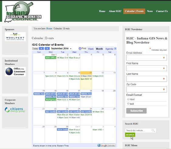
8 Where You Find Us


9 Where You Find Us Mounds State Park:
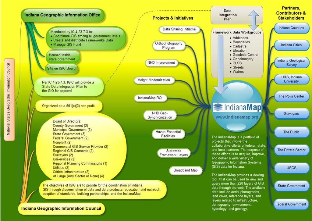
10 HOW INDIANAMAP WORKS IGIC Board of Directors IndianaMap Steering Committee All IGIC Framework Layer Workgroups
11 IndianaMap Our Cornerstone Initiative is the One Map for Indiana It s Statewide It s Regional It s Local It s Yours! ONE MAP FOR INDIANA Enable improved government service to citizens, and an enhanced ability for citizens to stay informed and to engage in the democratic process

12 Build Once, Use Many Times IndianaMap Principle Framework Data Your Data / Other Thematic Data Parcels & Ownership Streets & Addresses PLSS Water Boundaries Elevation Orthophotography Zoning Wetlands Landcover Infrastructure Water Lines Soils Geodetic Control
 framework data layers, provided by local (authoritative sources) together with")
 geospatial information")
13 IndianaMap is a Portfolio of Projects IndianaMap Vision Integration of the best available (authoritative) framework data layers, provided by local (authoritative sources) together with state and federal data Access provided through a webportal with tiered access for decision-makers and the public to view, download, and web-serve (trusted) geospatial information from a (trusted source)
14


15 Hoosier Hospitality Data Sharing & Project Partnerships Federal Government State Government Cities & Towns Private Sector Counties Universities 15
16 INDIANAMAP EXAMPLES

17 IndianaMap Examples INDIANAMAP COUNTY DATA SHARING INITIATIVE IGIC Data Sharing Committee IGIC Data Integration Committee IGIC Streets and Addresses Workgroup IGIC Boundaries, Cadastre, PLSS Workgroup

18 IndianaMap County Data Sharing

19 IndianaMap County Data Sharing Current 5,095 Government Unit Boundaries 596,004 Street Centerlines Segments 3,073,259 Point Addresses 3,576,544 Land Parcels

20 Example of Parcel Data
21 IndianaMap County Data Sharing GU In 2015 we plan to release a new IndianaMap public distribution dataset that includes New Enhanced Data Model based on Esri s Local Government Model* New added-value (feature attributes, tables and GIS capabilities) Administrative Boundaries Address_E SiteAddressPoint Parcels DLGF Parcel Land Building Improve Dwelling TaxParcel TaxParcel Points Owner Parcels Centerline_ E RoadCenterline Master Street *FREE Template from Esri includes dozens of free Applications to support Desktop, Web and Mobile GIS users.
22 IndianaMap Examples STATEWIDE ORTHOPHOTOGRAPHY & ELEVATION DATA PROGRAM IGIC Orthophotography Workgroup IGIC Elevation Workgroup
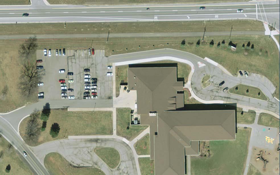
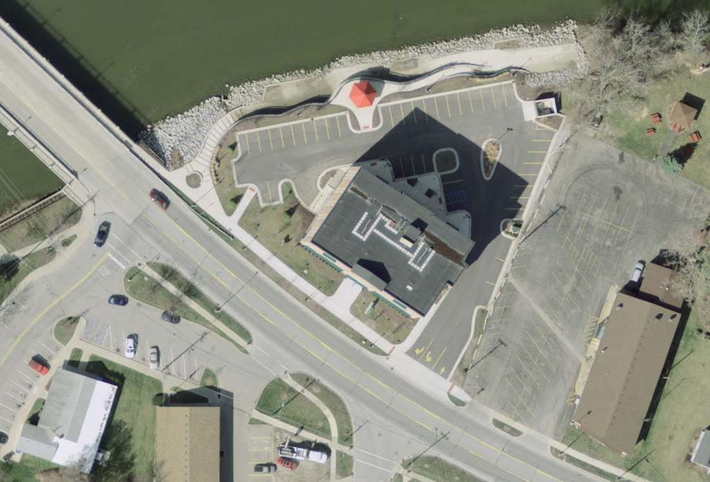

23 Orthophotography 1 Foot Pixel 6 Inch Pixel 3 Inch Pixel


24 Evolution of Statewide Elevation Data Improvements in resolution 30 m DEM SW of Martinsville, Indiana 10 m DEM 5 foot [1.5 m] DEM Slide Courtesy of Todd Indiana Geological Survey


25 Elevation Data LiDAR Point Cloud Data
26 2005 Statewide Ortho & Elevation Project IGIC Orthophotography Workgroup: Develop RFP, provides project Technical Support, Independent QA/QC Coordination, Data Archive and Data Distribution Support. Project: 1 year cycle, contracted and administered through Indiana Office of Technology, State Geographic Information Officer Base Products ($8.0 million) 1 Pixel Resolution RGB & NIR Imagery Products 10 C.I. Accuracy, 5 Pixel Digital Elevation Model Available Buy-up Options 6 -inch Resolution Ortho
27 Statewide Ortho-LiDAR Project IGIC Orthophotography & Elevation Workgroups: Develop RFP, provides project Technical Support, Independent QA/QC, Data Archive and Data Distribution Support. Project: 3- year cycle, contracted and administered through Indiana Office of Technology, State Geographic Information Officer Base Products ($4.6 million) 1 Pixel Resolution 4-Band Imagery USGS-compliant, 1.5 meter pulse spacing LiDAR 2 C.I. Accuracy, 5 Pixel Hydro-Flattened Digital Elevation Model (DEM) Available Buy-up Options 6 -inch Resolution Ortho 3 -inch Resolution Ortho 1-meter nominal pulse spacing LiDAR


28 IGIC Orthophotography Workgroup: Develop RFP and provide project Technical Support, Independent QA/QC, Data Archive and Data Distribution Support. Project: 3- year cycle, contracted and administered through Indiana Office of Technology, State Geographic Information Officer Base Products (Cost t.b.d.) 1 Pixel Resolution 4-Band Imagery Available Buy-up Options 6 -inch Resolution Ortho 3 -inch Resolution Ortho Statewide Ortho Project (Proposed).7 -meter pulse spacing LiDAR (2 points per meter)

29 DEP Statewide LiDAR Project (Proposed) USGS 3D Elevation Program (3DEP) Broad Area Announcement for 8-year Nationwide Collection Cycle. IGIC Elevation Workgroup: Developed Pre-Proposal to provide Contract Administration, Technical Support, Independent QA/QC, Data Archive and Data Distribution Support Project: 4 - year cycle, contracted and administered by IGIC Base Products (Proposed $6.9 Million) $5.5 Million USGS & $1.4 Million Local Match meter pulse spacing raw and classified LiDAR (2 points per meter) 10 CM Vertical Accuracy 1 C.I. Accuracy, 1 meter Pixel Hydro-flattened DEM & DSM products.
30 IndianaMap Examples LOCAL-RESOLUTION NHD ENHANCEMENTS IGIC Waters Workgroup IGIC Waters Watershed Boundary Subcommittee
: 2,177 Flowlines; 2,571 Waterbodies Local-Res NHD (1:2,400): 47,821")
31 Creating Local-Resolution NHD High-Res NHD (1:24.000): 2,177 Flowlines; 2,571 Waterbodies Local-Res NHD (1:2,400): 47,821 Flowlines; 3,350 Waterbodies

32 Local-Resolution NHD Enhancements New Stream & Waterbody Names Need to be Added to GNIS


33 Local-Resolution NHD Enhancements New Stream & Waterbody Names Need to be Added to GNIS

34 Local-Resolution NHD Enhancements Watershed Boundaries Need to be Updated
35 IGIC WHAT S NEXT? Moving IndianaMap to the Cloud
36 IGIC What s Next? Moving the IndianaMap to the Cloud INDIANAMAP - ARCGIS.COM (ARCGIS ONLINE FOR ORGANIZATIONS) IGIC Board of Directors IndianaMap Steering Committee All IGIC Framework Layer Workgroups

37 IndianaMap Services on ArcGIS.com (Coming Soon)

38 IndianaMap Services on ArcGIS.com
39 IndianaMap Services on ArcGIS.com

40 IndianaMap Services on ArcGIS.com
41 IndianaMap Services on ArcGIS.com

42 IndianaMap Services on ArcGIS.com

43 IndianaMap Services on ArcGIS.com
44 IGIC What s Next? Moving the IndianaMap to the Cloud INDIANAMAP OPEN DATA PORTAL IGIC Board of Directors IndianaMap Steering Committee All IGIC Framework Layer Workgroups


45 IndianaMap Open Data Portal on ArcGIS.com


46
47 Phil Worrall IGIC Executive Director
BRIEF EXAMPLES OF PRACTICAL USES OF LIDAR
 BRIEF EXAMPLES OF PRACTICAL USES OF LIDAR PURDUE ROAD SCHOOL - 3/9/2016 CHRIS MORSE USDA-NRCS, STATE GIS COORDINATOR LIDAR/DEM SOURCE DATES LiDAR and its derivatives (DEMs) have a collection date for data
3D Elevation Program GeoCue Webinar April 29, The National Map
 + 3D Elevation Program GeoCue Webinar April 29, 2014 The National Map + 3D Elevation Program (3DEP) 2 Topics What is the 3DEP? Overview and background: National Elevation Dataset National Enhanced Elevation
PROJECT BRIEFINGS: Statewide 2008 Orthoimagery LiDAR Elevation Data Program MN Geospatial Information Office. Chris Cialek
 PROJECT BRIEFINGS: Statewide 2008 Orthoimagery LiDAR Elevation Data Program MN Geospatial Information Office Chris Cialek MN Land Management Information Center (LMIC) chris.cialek@state.mn.us Mid-West
Workshops funded by the Minnesota Environment and Natural Resources Trust Fund
 Workshops funded by the Minnesota Environment and Natural Resources Trust Fund Conservation Applications of LiDAR Data Workshops funded by: Minnesota Environment and Natural Resources Trust Fund Presented
Lidar Talking Points Status of lidar collection in Pennsylvania Estimated cost and timeline
 Lidar Talking Points Pennsylvania has an immediate need for new lidar (topographic) data coverage. Some uses of the data are enumerated later in this document. USGS has calculated an average return on
Fusing LiDAR and Imagery: Providing Effective Solutions for Ohio s s Transportation Infrastructure
 Fusing LiDAR and Imagery: Providing Effective Solutions for Ohio s s Transportation Infrastructure Dave Blackstone GIS Manager Ohio Department of Transportation Brian Stevens, CP Project Manager Woolpert
Hamilton County Enhances GIS Base Mapping with 1-foot Contours
 Hamilton County Enhances GIS Base Mapping with 1-foot Contours Presented by Larry Stout, Hamilton County GIS Manager Brad Fugate, Woolpert Inc. Today s Presentation Hamilton County s 2004 Base Mapping
High resolution survey and orthophoto project of the Dosso-Gaya region in the Republic of Niger. by Tim Leary, Woolpert Inc.
 High resolution survey and orthophoto project of the Dosso-Gaya region in the Republic of Niger by Tim Leary, Woolpert Inc. Geospatial Solutions Photogrammetry & Remote Sensing LiDAR Professional Surveying
Data Acquisition Through the Geospatial Products and Services Contract (GPSC)
") Data Acquisition Through the Geospatial Products and Services Contract (GPSC) Kathryn Yoder GPSC COTR ESRI, 2015 U.S. Department of the Interior U.S. Geological Survey Overview Background Info Acquisition
Data Acquisition Through the Geospatial Products and Services Contract (GPSC) Kathryn Yoder GPSC COTR ESRI, 2015 U.S. Department of the Interior U.S. Geological Survey Overview Background Info Acquisition
PWA GIS. Minnesota Department of Transportation (Mn/DOT) Cadastral and Right of Way Data Sharing Pilot Project. Phase 1 and Phase 2 Summary Report
 Cadastral and Right of Way Data Sharing Pilot Project. Phase 1 and Phase 2 Summary Report") Minnesota Department of Transportation (Mn/DOT) Cadastral and Right of Way Data Sharing Pilot Project Phase and Phase Summary Report December, 7 Pro-West & Associates, Inc. Geographic Information System
Minnesota Department of Transportation (Mn/DOT) Cadastral and Right of Way Data Sharing Pilot Project Phase and Phase Summary Report December, 7 Pro-West & Associates, Inc. Geographic Information System
Technical Considerations and Best Practices in Imagery and LiDAR Project Procurement
 Technical Considerations and Best Practices in Imagery and LiDAR Project Procurement Presented to the 2014 WV GIS Conference By Brad Arshat, CP, EIT Date: June 4, 2014 Project Accuracy A critical decision
3D Elevation Program- Status and Updates. Claire DeVaughan South Central Arc User Group Conference April 11, 2018
 + 1 3D Elevation Program- Status and Updates Claire DeVaughan South Central Arc User Group Conference April 11, 2018 + 2 3D Elevation Program (3DEP) Goals Complete acquisition in 8 years Address Federal,
GIS Tools for Hydrology and Hydraulics
 1 OUTLINE GIS Tools for Hydrology and Hydraulics INTRODUCTION Good afternoon! Welcome and thanks for coming. I once heard GIS described as a high-end Swiss Army knife: lots of tools in one little package
IndianaMap Release 3. Rick Hill, Paul Rohwer,, Chris Dintaman, Becky Meyer, and Denver Harper
 IndianaMap Release 3 Rick Hill, Paul Rohwer,, Chris Dintaman, Becky Meyer, and Denver Harper IndianaMap Agenda Session 1 & 2 Overview Tentative rollout schedule Old versus New Design and construction of
Disaster Mitigation Projects in Polis. December 14, 2016
 1 Disaster Mitigation Projects in Polis December 14, 2016 Briefing Agenda 2 About Polis Multi s Mitigation Planning Flood s s Disaster Mitigation Platforms Consultancies Training Discussion 3 About us
Feature Extraction from Imagery & Lidar. Kurt Schwoppe, Esri Mark Romero, Esri Gregory Bacon, Fairfax County
 Feature Extraction from & Lidar Kurt Schwoppe, Esri Mark Romero, Esri Gregory Bacon, Fairfax County Today s Speakers Image Processing Experts and Good Colleagues Kurt Schwoppe Industry Lead Esri Mark Romero
Standardized Data Production Strategies Across Your Enterprise
 Federal GIS Conference February 9 10, 2015 Washington, DC Standardized Data Production Strategies Across Your Enterprise Amber Bethell Sherry Fagin Authoritative content producers Knowledge Workers Executive
Designing and Using Basemaps. Jennifer Hughey
 Designing and Using Basemaps Jennifer Hughey Agenda The ArcGIS System Basemaps are a key component of your system Cartographic design considerations Using basemap layers in ArcMap Best practices for designing
Alaska Department of Transportation Roads to Resources Project LiDAR & Imagery Quality Assurance Report Juneau Access South Corridor
 Alaska Department of Transportation Roads to Resources Project LiDAR & Imagery Quality Assurance Report Juneau Access South Corridor Written by Rick Guritz Alaska Satellite Facility Nov. 24, 2015 Contents
Connecticut Association of Assessing Officers CT Statewide GIS Data Acquisition & Services. June 22, :00 am
 Connecticut Association of Assessing Officers 2016 CT Statewide GIS Data Acquisition & Services June 22, 2016 9:00 am Presented by: Shawn Benham, PMP Project Manager ---------------------------- Brad Arshat,
Creating Transparency, Openness and Trust: Modern Approach to Redistricting
 Creating Transparency, Openness and Trust: Modern Approach to Redistricting Richard Leadbeater, Esri Jerry Howe, Utah Legislature Larry Boden, Esri NCSL Legislative Summit Sunday, Aug. 6 11:15 am-12:15
STATEWIDE CENTERLINE INITIATIVE EDITED: MAY 17, 2013
 STATEWIDE CENTERLINE INITIATIVE EDITED: MAY 17, 2013 WHAT IS THE CENTERLINE INITIATIVE? The Centerline Initiative is a joint effort between the Minnesota Department of Transportation (MnDOT), Minnesota
PUBLIC WORKS. 1oo. DiEital Fee Schedules. Effective January 1, 2008
 PUBLIC WORKS Geographic Information Systems DiEital Fee Schedules Effective January 1, 2008 Date Advertised 12103/07 In (Publication) Daily Business Journal Public Hearing Date Approved as to form: David
ArcGIS Hub: Open data best practices. Graham Hudgins, esri product engineer
 ArcGIS Hub: Open data best practices Graham Hudgins, esri product engineer Agenda Overview of open data in the ArcGIS Hub Example sites - Hubs Around the World Storymap Making a good site map Preparing
IMAGERY FOR ARCGIS. Manage and Understand Your Imagery. Credit: Image courtesy of DigitalGlobe
 IMAGERY FOR ARCGIS Manage and Understand Your Imagery Credit: Image courtesy of DigitalGlobe 2 ARCGIS IS AN IMAGERY PLATFORM Empowering you to make informed decisions from imagery and remotely sensed data
Missouri Spatial Data Information Service 1st Period Bi-Annual Report February 2015 July 2015
 Missouri Spatial Data Information Service 1st Period Bi-Annual Report February 2015 July 2015 Build or implement a survey to identify gaps in the statewide data inventory. Strategy: Watch the development
Absolute Horizontal Accuracies of Pictometry s Individual Orthogonal Frame Imagery
 A Pictometry International, Corp White Paper Absolute Horizontal Accuracies of Pictometry s Individual Orthogonal Frame Imagery Michael J. Zoltek VP, Surveying & Mapping Pictometry International, Corp
Singapore. Mr Soh Kheng Peng. Singapore Land Authority
 Country Report 2006 (Based on the PCGIAP-Data Integration Template 2006) Singapore Country/state: Name of contact person: Affiliation, Organization: Function, Position: Address: Email address: Tel, Fax
GEOGRAPHIC INFORMATION SYSTEMS Lecture 02: Feature Types and Data Models
 GEOGRAPHIC INFORMATION SYSTEMS Lecture 02: Feature Types and Data Models Feature Types and Data Models How Does a GIS Work? - a GIS operates on the premise that all of the features in the real world can
Using LiDAR (Light Distancing And Ranging) data to more accurately describe avalanche terrain
 data to more accurately describe avalanche terrain") International Snow Science Workshop, Davos 009, Proceedings Using LiDAR (Light Distancing And Ranging) data to more accurately describe avalanche terrain Christopher M. McCollister, and Robert H. Comey,
International Snow Science Workshop, Davos 009, Proceedings Using LiDAR (Light Distancing And Ranging) data to more accurately describe avalanche terrain Christopher M. McCollister, and Robert H. Comey,
California GIS Enterprise Strategy
 California GIS Enterprise Strategy David Harris Geospatial Information Officer California Natural Resources Agency December 3, 2009 Outline OCIO / GIO Background California GIS Task Force Report California
PROJECT REPORT. Allegany County Acquisition and Classification for FEMA Region 3 FY 12 VA LiDAR. USGS Contract: G12PD00040.
 PROJECT REPORT For the Allegany County Acquisition and Classification for FEMA Region 3 FY 12 VA LiDAR USGS Contract: G12PD00040 Prepared for: United States Geological Survey & Federal Emergency Management
Name * Organization/Agency Name * State * Address * State of State GIS. Jon Gottsegen. ce of Information Technology.
 The primary purpose of the GMA is to provide NSGIC members, its sponsors, and other partners with a detailed summary of geospatial initiatives, capabilities, and issues within and across state governments.
Homeland Security and Geographic Information Systems
 Page 1 of 5 Homeland Security and Geographic Information Systems How GIS and mapping technology can save lives and protect property in post-september 11th America Introduction Timely, accurate information,
Name * Organization/Agency Name * State * Address * State of State GIS. Julia Fischer. Department of Information Technology.
 The primary purpose of the GMA is to provide NSGIC members, its sponsors, and other partners with a detailed summary of geospatial initiatives, capabilities, and issues within and across state governments.
Managing Imagery and Raster Data using Mosaic Datasets
 Esri European User Conference October 15-17, 2012 Oslo, Norway Hosted by Esri Official Distributor Managing Imagery and Raster Data using Mosaic Datasets Peter Becker ArcGIS is a Comprehensive Imagery
2010 LiDAR Project. GIS User Group Meeting June 30, 2010
 2010 LiDAR Project GIS User Group Meeting June 30, 2010 LiDAR = Light Detection and Ranging Technology that utilizes lasers to determine the distance to an object or surface Measures the time delay between
Information Technology Community Involvement
 Information Technology Community Involvement Tom Hoover Associate Vice Chancellor Helping students achieve through technology Information Technology at the University of Tennessee Chattanooga is focused
Enterprise Geospatial Activities in the Bureau of Reclamation Mid-Pacific Region
 in the Bureau of Reclamation Mid-Pacific Region Toward an Organizational Nervous System?? Lorri Peltz-Lewis, Regional Geospatial Database Administrator and Dave Hansen, GIS Specialist What is Enterprise?
City of La Crosse Online Mapping Website Help Document
 City of La Crosse Online Mapping Website Help Document This document was created to assist in using the new City of La Crosse online mapping sites. When the website is first opened, a map showing the City
Managing Lidar and Photogrammetric Point Clouds. Lindsay Weitz Cody Benkelman
 and Photogrammetric Point Clouds Lindsay Weitz Cody Benkelman Presentation Context What is lidar, and how does it work? Not this presentation! What can you do with lidar in ArcGIS? What does Esri recommend
Bringing Singapore to life in 3D
 Bringing Singapore to life in 3D Dr Victor Khoo, Deputy Director Singapore Land Authority Bringing Singapore to life in 3D ESRI Singapore UC 2016 Dr. Victor Khoo Singapore Land Authority SLA 2016 RESTRICTED
Washington Statewide Trails Database Project
 Washington Statewide Trails Database Project Project Overview Washington still is missing a statewide trails database. To date, some of the state and federal hiking, biking, horse and rail trails data
Community Resilience Scenario Planning Model
 Community Resilience Scenario Planning Model Technical User Guide American Planning Association Making Great Communities Happen This Technical User Guide was developed by Focused Planning Solutions, Inc.,
 Plone development in UNEP Country Environmental Profiles Gerard.Cunningham@unep.org Capacity Building and Partnerships Section Division of Early Warning and Assessment United Nations Environment Programme
Transportation for the Nation (TFTN) GIS-T Symposium
 GIS-T Symposium") Strategic Plan for Transportation for the Nation (TFTN) GIS-T Symposium Steve Lewis Geospatial Information Officer, USDOT Director, Office of Geospatial Information Systems, USDOT/RITA/BTS March, 2011
Strategic Plan for Transportation for the Nation (TFTN) GIS-T Symposium Steve Lewis Geospatial Information Officer, USDOT Director, Office of Geospatial Information Systems, USDOT/RITA/BTS March, 2011
The Address Point Data Standard for Minnesota Overview and Frequently Asked Questions
 The Address Point Data Standard for Minnesota Overview and Frequently Asked Questions Introduction. Address points are a core geospatial infrastructure dataset for Minnesota. They are a foundational data
Overview. 1. Aerial LiDAR in Wisconsin (20 minutes) 2. Demonstration of data in CAD (30 minutes) 3. High Density LiDAR (20 minutes)
 2. Demonstration of data in CAD (30 minutes) 3. High Density LiDAR (20 minutes)") Overview 1. Aerial LiDAR in Wisconsin (20 minutes) 2. Demonstration of data in CAD (30 minutes) 3. High Density LiDAR (20 minutes) 4. Aerial lidar technology advancements (15 minutes) 5. Q & A 1. Aerial
Overview 1. Aerial LiDAR in Wisconsin (20 minutes) 2. Demonstration of data in CAD (30 minutes) 3. High Density LiDAR (20 minutes) 4. Aerial lidar technology advancements (15 minutes) 5. Q & A 1. Aerial
PDOK. Part of the Dutch SDI, growing from portal to platform. Haico van der Vegt Strategic Advisor Kadaster
 PDOK Part of the Dutch SDI, growing from portal to platform Haico van der Vegt Strategic Advisor Kadaster PDOK public services on the map Geo-webservices distribution portal E-Government initiative Open,
QUESTIONS & ANSWERS FOR. ORTHOPHOTO & LiDAR AOT
 QUESTIONS & ANSWERS FOR ORTHOPHOTO & LiDAR AOT Question# 1. Section 3.2 Will the imagery be clipped to the 1000m boundary? If so, what color will be used for null valued pixels? Yes, the imagery will be
Ministry of Sustainable Resource Management. Data Sales Panel. Presentation to URISA BC Chapter Richmond, 2002
 Ministry of Sustainable Resource Management Data Sales Panel Presentation to URISA BC Chapter Richmond, 2002 Evert Kenk Business and Information Services Division MSRM Who we are. Agenda Data, Data and
California s Public Libraries and CENIC: Frequently Asked Questions
 Leading the Way to Tomorrow s Internet The Corporation for Education Network Initiatives in California California s Public Libraries and CENIC: Frequently Asked Questions What is CENIC? CENIC, the Corporation
Compass INSPIRE Services. Compass INSPIRE Services. White Paper Compass Informatics Limited Block 8, Blackrock Business
 Compass INSPIRE Services White Paper 2010 Compass INSPIRE Services Compass Informatics Limited Block 8, Blackrock Business Park, Carysfort Avenue, Blackrock, County Dublin, Ireland Contact Us: +353 1 2104580
LOCAL STREETS AND THE ARNOLD INITIATIVE
 LOCAL STREETS AND THE ARNOLD INITIATIVE Jenn Sylvester, Mapping Branch Team Lead Transportation Planning & Programming Division (TPP) GIS-T Symposium Des Moines, IA Key Terms 1 2 3 ARNOLD FC Streets Local
Should Contours Be Generated from Lidar Data, and Are Breaklines Required? Lidar data provides the most
 Should Contours Be Generated from Lidar Data, and Are Breaklines Required? Lidar data provides the most accurate and reliable representation of the topography of the earth. As lidar technology advances
New Mexico s RGIS Program: State Geospatial Data Clearinghouse
 New Mexico s RGIS Program: State Geospatial Data Clearinghouse Laura Gleasner Su Zhang November 10, 2016 New Mexico RGIS: The State Digital Geospatial Data Clearinghouse The Resource Geographic Information
State of Minnesota Enterprise GIS Opportunity Assessment 1 Introduction & Context 2 Minnesota Enterprise GIS Requirements & Activities
 State of Minnesota Enterprise GIS Opportunity Assessment September, 2008 1 Introduction & Context The following presents a high-level overview of the opportunities that exist to deploy GIS services and
GEOG 487 Lesson 2: Step-by-Step Activity
 GEOG 487 Lesson 2: Step-by-Step Activity In Lesson 2, we are going to create a website that contains interactive maps with datasets related to our project scenario described in the Introduction. We will
Modernizing California State Highway Right of Way Records with GIS. Caltrans District 4 Oakland, CA
 Modernizing California State Highway Right of Way Records with GIS Caltrans District 4 Oakland, CA About Us Kirsten Lawrence (GISP), Senior Geospatial Analyst on staff augmentation contract with Caltrans
Building a National Address Database. Presented by Steve Lewis, Department of Transportation Mark Lange, Census Bureau July 13, 2017
 Building a National Address Database Presented by Steve Lewis, Department of Transportation Mark Lange, Census Bureau July 13, 2017 Topics Building the NAD FGDC Address Theme 2 Building the NAD 3 First
National Ground Water Monitoring Network: Lessons from Planning a Collaborative National Ground Water Monitoring Network
 National Ground Water Monitoring Network: Lessons from Planning a Collaborative National Ground Water Monitoring Network William L. Cunningham U.S. Geological Survey Water in the West Workshop #2 January
Using analytical tools in ArcGIS Online to determine where populations vulnerable to flooding and landslides exist in Boulder County, Colorado.
 Using analytical tools in ArcGIS Online to determine where populations vulnerable to flooding and landslides exist in Boulder County, Colorado. Estimated Time to complete: 1-2 hours Learning Objective:
Imagery and Raster Data in ArcGIS. Abhilash and Abhijit
 Imagery and Raster Data in ArcGIS Abhilash and Abhijit Agenda Imagery in ArcGIS Mosaic datasets Raster processing ArcGIS is a Comprehensive Imagery System Integrating All Types, Sources, and Sensor Models
Development and Implementation of the National Ground-Water Monitoring Network
 Development and Implementation of the National Ground-Water Monitoring Network Daryll Pope, USGS Ground Water Protection Council Annual Forum September 28-30, 2015 Oklahoma City, Oklahoma Presentation
Drone2Map for ArcGIS: Bring Drone Imagery into ArcGIS. Will
 Drone2Map for ArcGIS: Bring Drone Imagery into ArcGIS Will Meyers @MeyersMaps A New Window on the World Personal Mapping for Micro-Geographies Accurate High Quality Simple Low-Cost Drone2Map for ArcGIS
SAGIS Property Map Viewer Instruction Manual Instructions for using the SAGIS Property Map Viewer. Published December 21, 2018.
 SAGIS Property Map Viewer Instruction Manual www.sagis.org/map Instructions for using the SAGIS Property Map Viewer. Published December 21, 2018. 1 Instructional Videos Click on a link to watch a video
Peoria County Front Desk Map Application
 Peoria County Front Desk Map Application Quick Guide, 2017 At a First Glance This guide will tell users all they need to know about the Peoria County Front Desk application which can be found on the Peoria
Assimilation of Break line and LiDAR Data within ESRI s Terrain Data Structure (TDS) for creating a Multi-Resolution Terrain Model
 for creating a Multi-Resolution Terrain Model") Assimilation of Break line and LiDAR Data within ESRI s Terrain Data Structure (TDS) for creating a Multi-Resolution Terrain Model Tarig A. Ali Department of Civil Engineering American University of Sharjah,
Assimilation of Break line and LiDAR Data within ESRI s Terrain Data Structure (TDS) for creating a Multi-Resolution Terrain Model Tarig A. Ali Department of Civil Engineering American University of Sharjah,
Army ITAM GIS: Utilizing ArcSDE and SDSFIE to Support the Enterprise
 Army ITAM GIS: Utilizing ArcSDE and SDSFIE to Support the Enterprise Gary Senseman ITAM GIS Western Regional Support, Center for Environmental Management of Military Lands, Colorado State University, Fort
Remote sensing techniques applied to seismic vulnerability assessment
 Remote sensing techniques applied to seismic vulnerability assessment JJ Arranz (josejuan.arranz@upm.es), Y. Torres (y.torres@upm.es), A. Haghi (a.haghi@alumnus.upm.es), J. Gaspar (jorge.gaspar@upm.es)
Canada Green Building Council - Greater Toronto Chapter 3-Year Strategic Plan, BUILDING MOMENTUM 3-YEAR STRATEGIC PLAN ( )
") Canada Green Building Council - Greater Toronto Chapter BUILDING MOMENTUM 3-YEAR STRATEGIC PLAN (2017-2019) Canada Green Building Council - Greater Toronto Chapter Preface About the Canada Green Building
Canada Green Building Council - Greater Toronto Chapter BUILDING MOMENTUM 3-YEAR STRATEGIC PLAN (2017-2019) Canada Green Building Council - Greater Toronto Chapter Preface About the Canada Green Building
Frequently Asked Questions
 ArcGIS Online Map This map will support Forest Stewards, partner organizations, and contractors in carrying out the mission of the Green Seattle Partnership (GSP). Maps help communicate about work areas
What s New in Imagery in ArcGIS. Presented by: Christopher Patterson Date: October 18, 2017
 What s New in Imagery in ArcGIS Presented by: Christopher Patterson Date: October 18, 2017 Imagery in ArcGIS Advancing 2010 Stretch, Extract Bands Clip, Mask Reproject, Orthorectify, Pan Sharpen Vegetation
Manitowoc County, WI Advanced Access GIS Viewer User Documentation
 Manitowoc County, WI Advanced Access GIS Viewer User Documentation Introduction Extensive time was put into developing this website both from a display, and from a printing and scaling perspective. This
The Proposed Road Centerline Standard for Minnesota Overview and Frequently Asked Questions
 The Proposed Road Centerline Standard for Minnesota Overview and Frequently Asked Questions Introduction. Road Centerlines are a foundational geospatial dataset for Minnesota. They are a foundational data
Raster Serving with ArcGIS
 Raster Serving with ArcGIS Agenda Introduction to server technology Workflow considerations ESRI raster serving technology ArcGIS Server Basic (ArcSDE) ArcGIS Server Standard/Advanced Web Services ArcGIS
Aerial and Mobile LiDAR Data Fusion
 Creating Value Delivering Solutions Aerial and Mobile LiDAR Data Fusion Dr. Srini Dharmapuri, CP, PMP What You Will Learn About LiDAR Fusion Mobile and Aerial LiDAR Technology Components & Parameters Project
Section One: Identification. Cadastral Publication Data Guideline Metadata Last Revised November 2009
 Cadastral Publication Data Guideline Metadata Last Revised November 2009 The suggested metadata for published cadastral data follows the format suggested by the Federal Geographic Data Committee (FGDC)
MassCEC Rooftop Solar Map
 MassCEC Rooftop Solar Map Data and Methods Summary Critigen, LLC Overview The detailed analysis of solar rooftop potential is a multi-step workflow with many facets and input parameters to the analysis
Annual Report for the Utility Savings Initiative
 Report to the North Carolina General Assembly Annual Report for the Utility Savings Initiative July 1, 2016 June 30, 2017 NORTH CAROLINA DEPARTMENT OF ENVIRONMENTAL QUALITY http://portal.ncdenr.org Page
ENVI THE PREMIER SOFTWARE FOR EXTRACTING INFORMATION FROM GEOSPATIAL DATA
 ENVI THE PREMIER SOFTWARE FOR EXTRACTING INFORMATION FROM GEOSPATIAL DATA HarrisGeospatial.com BENEFITS Use one solution to work with all your data types Access a complete suite of analysis tools Customize
INSPIRE overview and possible applications for IED and E-PRTR e- Reporting Alexander Kotsev
 INSPIRE overview and possible applications for IED and E-PRTR e- Reporting Alexander Kotsev www.jrc.ec.europa.eu Serving society Stimulating innovation Supporting legislation The European data puzzle 24
A Strategy and Vision for Enterprise 3D GIS. B r o o k s P a t r i c k A c c o u n t E x e c u t i v e b p a t r i c e s r i.
 A Strategy and Vision for Enterprise 3D GIS B r o o k s P a t r i c k A c c o u n t E x e c u t i v e b p a t r i c k @ e s r i. c o m Understanding where things are, and why, is essential for rational
Drone2Map for ArcGIS: Bring Drone Imagery into ArcGIS
 Drone2Map for ArcGIS: Bring Drone Imagery into ArcGIS Mike Sweeney 1 Drone2Map for ArcGIS Turn Drones into Enterprise Productivity Tools ArcGIS Drone2Map for ArcGIS Create 2D and 3D products from raw drone
LIDAR 101 & 2014 MO/AR LIDAR PARTNERS PROJECT. NEMO GIS Workshop
 LIDAR 101 & 2014 MO/AR LIDAR PARTNERS PROJECT NEMO GIS Workshop May 22, 2014 PRESENTER Tim Donze Business Development Surdex Corporation PRESENTATION TOPICS What is LiDAR? Why is LiDAR Valuable? Missouri
Data Acquisition; Maintenance, and Dissemination
 Data Acquisition; Maintenance, and Dissemination Amar Nayegandhi, CP, CMS(RS), GISP Director of Remote Sensing Dewberry December 4, 2014 About MAPPS + MAPPS is the only national association of private
GEOFidelis Program Update
 GEOFidelis Program Update JSEM & Geospatial Conference Columbus, OH 22 May 2007 Organization Secretary of the Navy CNO CMC GEOFidelis Program Office MCI NCR MCI East MCRD ERR MCI West MCRD WRR MCI Mid
Technology & GIS During Sandy Recovery. Outline
 Technology & GIS During Sandy Recovery Picture provided by US Army Corps of Engineers Mayor Michael R. Bloomberg Commissioner Janette Sadik-Khan New York City Department of Transportation 07/18/13 Outline
UTILIZACIÓN DE DATOS LIDAR Y SU INTEGRACIÓN CON SISTEMAS DE INFORMACIÓN GEOGRÁFICA
 UTILIZACIÓN DE DATOS LIDAR Y SU INTEGRACIÓN CON SISTEMAS DE INFORMACIÓN GEOGRÁFICA Aurelio Castro Cesar Piovanetti Geographic Mapping Technologies Corp. (GMT) Consultores en GIS info@gmtgis.com Geographic
Bay Area Regional Bicycle Share Pilot Project. Karen Schkolnick, BAAQMD SPUR Evening Forum: Bike Sharing Around the Bay June 25, 2013
 Bay Area Regional Bicycle Share Pilot Project Karen Schkolnick, BAAQMD SPUR Evening Forum: Bike Sharing Around the Bay June 25, 2013 1 Overview Pilot Project Background and Goals Roadmap, Regional Process
The Africa Utilities Telecom Council Johannesburg CC, South Africa 1 st December, 2015
 The Africa Utilities Telecom Council Johannesburg CC, South Africa 1 st December, 2015 Utilities Telecom Council Global Focus on Utility Information and Communications Technology (ICT) Formed more than
Paul Hardy. We Live in a Rapidly Changing World. Mobile Mapping: Collect, Manage, Produce, Share. MMT Krakow, Many Forces Are Converging
 Mobile Mapping: Collect, Manage, Produce, Share MMT Krakow, 2011 Paul Hardy We Live in a Rapidly Changing World Increasingly Driven by Population Growth & Human Action Impacting Environment Society Economy
Next Generation The Kansas Story
 Next Generation 9-1-1 The Kansas Story NG9-1-1 The Kansas Story Strategy Implementation Chief Dick Heitschmidt Jay Coverdale 3 The Kansas Story Part 1 Chief Dick Heitschmidt 9-1-1 Coordinating Council,
ArcGIS for Server Imagery Update. Cody A. Benkelman Technical Product Manager, Imagery
 ArcGIS for Server Imagery Update Cody A. Benkelman Technical Product Manager, Imagery Outline Mosaic dataset Management and dissemination of imagery - Dynamic image services, Tiled Cache Visualization
USE CASE STUDY. Leveraging Data Through Partnerships The United States Agency for International Development (USAID)
") USE CASE STUDY Leveraging Data Through Partnerships The United States Agency for International Development (USAID) A Product of the Federal CIO Council Innovation Committee VERSION 1.0 / 2015 USE CASE
USE CASE STUDY Leveraging Data Through Partnerships The United States Agency for International Development (USAID) A Product of the Federal CIO Council Innovation Committee VERSION 1.0 / 2015 USE CASE
Minnesota Governor s Council on Geographic Information
 Minnesota Governor s Council on Geographic Information FY2009 end-of-year Committee Reports Accomplishments Future Plans Committees Digital Elevation Emergency Preparedness Hydrography Land Records Modernization
OAKLAND COUNTY, MICHIGAN GEOSPATIAL DATA ACCESS, DISTRIBUTION AND USE
 OAKLAND COUNTY, MICHIGAN GEOSPATIAL DATA ACCESS, DISTRIBUTION AND USE The following Geospatial Data Access, Distribution, and Use standard is designed to assist County employees and other approved users
Testimony. Christopher Krebs Director Cybersecurity and Infrastructure Security Agency U.S. Department of Homeland Security FOR A HEARING ON
 Testimony Christopher Krebs Director Cybersecurity and Infrastructure Security Agency U.S. Department of Homeland Security FOR A HEARING ON Defending Our Democracy: Building Partnerships to Protect America
Using Esri's Address Data Management Tools to Prepare for Next Generation 911
 Using Esri's Address Data Management Tools to Prepare for Next Generation 911 Chad Brothers, Client Services Manager State of Tennessee TeleCommunication Systems, Inc. James Wood, Public Safety Industry
Creating and Maintaining Your 3D Basemap. Brian Sims Dan Hedges Gert van Maren
 Creating and Maintaining Your 3D Basemap Brian Sims Dan Hedges Gert van Maren Complementary Resource Email (no marketing) A copy of the presentation Links to today s web demos Links to training materials