The UK Marine Environmental Data and Information Network MEDIN
|
|
|
- Samson Flynn
- 5 years ago
- Views:
Transcription
1 The UK Marine Environmental Data and Information Network MEDIN M. Charlesworth, R. Lowry, H. Freeman, J. Rapaport, B Seeley
2 Content MEDIN - a brief overview for context Discovery Metadata Standard and Tools Data Guidelines Controlled Vocabularies Governance

3 MEDIN in a nutshell Not just another marine application or initiative that meets a specific need or driver! Coordinates and encourages good management of data and information holdings across organisations and other thematic initiatives. Solve to make data easier to discover, access and use and then add resources and services on top Working to Deliver Improved Access to and Stewardship of UK Marine Data and Information


4 Why is data management in marine sector so important? Confidence in assessments and ability to detect trends limited By lack of access to data By lack of time to use existing data MEDIN has grown from previous work that have been in operation since 1996 but new push as MEDIN since 2007
5 How will MEDIN do it? Seven interlinked work streams: 1. Network of marine Data Archive Centres (DACs) 2. Suite of standards for data and metadata, together with guidelines and tools. 3. Web portal, products and services 4. International awareness, coordination and data delivery to global data-bases 5. Resource and application development 6. Communications: outreach, forums, publicity 7. Management, planning and coordination
6 Discovery Metadata Standard Compliant with the ISO19115 (Geographic information Metadata), INSPIRE and UK metadata standards and uses the ISO schema set for encoding xml Standard specifies use of certain vocabularies to make it marine flavoured To test xml constraints a Schematron has been developed (compliant with ISO (Part 3) Information technology -- Document Schema Definition Languages (DSDL) -- Part 3: Rule-based validation Schematron).


7 Discovery Metadata Standard On-line metadata generation tool ESRI Arc Catalogue plug in Submitting the standard to a joint oceanographic/metero logical commission

8 Data Guidelines Specific data types Not as detailed as INSPIRE data specifications but where relevant ones are drafted we will ensure compatibility
9 Data Guidelines Outcomes: Instil good practice amongst organisations Improve interoperability by organisations being able to import, export using this format Aid ingestion into DACs Be used in contracts
10 Controlled Vocabs Promoting use of vocabs in specific themes via data guidelines and deriving new vocabs where required Vocabs are available through 3 rd parties or alternatively served using the NERC vocab server developed in coordination with the european project SeaDataNet. An API returning XML documents conforming to a standard schema (SKOS (Simple Knowledge Organisation system)) allowing interaction with generic tools Governance and application follows the guiding principles of ISO19135 (Geographic information -- Procedures for item registration)


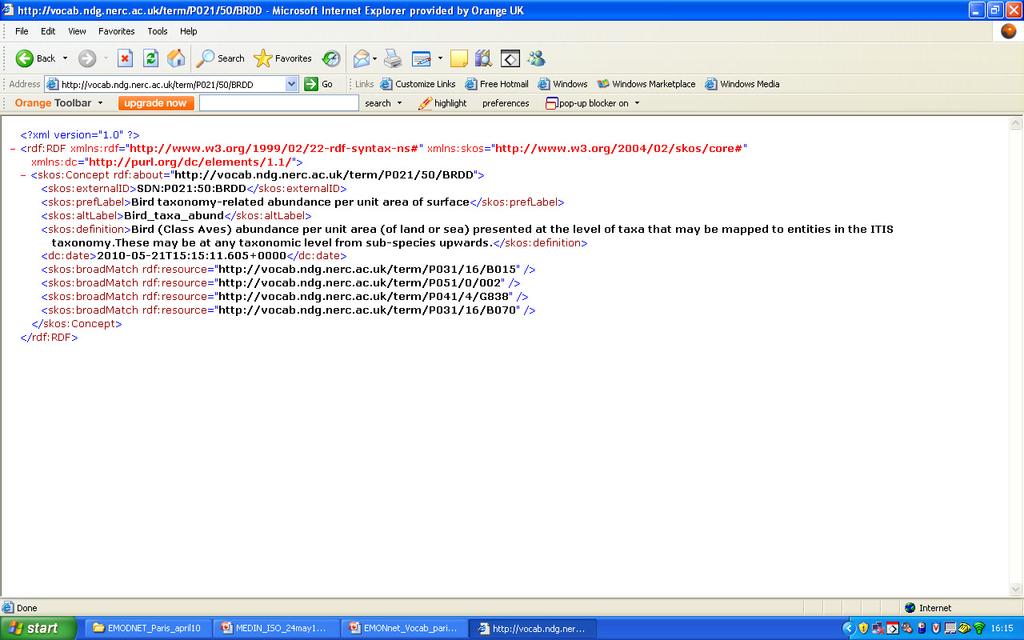
11 Controlled Vocabs Vocab Service:

12 Controlled Vocabs Vocab theasurus:
13 Standard Governance MEDIN Standards WG meets every 4-5 months and in interim by , phone conference as required Range of people (geographically, organisationally and technically) Sets and oversees work programme following input from other WGs


 Application 4 (raw")
14 The MEDIN Approach Resources and Services tools Application 2 (end user spatial information) Metadata Discovery Portal Application 1 (thematic discovery metadata) Application 3 (thematic evaluation metadata) Application 4 (raw thematic data) Data
15
A Thematic Approach to Data Management and Implementation of INSPIRE: The UK Marine Environmental Data and Information Network
 A Thematic Approach to Data Management and Implementation of INSPIRE: The UK Marine Environmental Data and Information Network Mark Charlesworth mecha@bodc.ac.uk www.oceannet.org Content Importance marine
Metadata for Data Discovery: The NERC Data Catalogue Service. Steve Donegan
 Metadata for Data Discovery: The NERC Data Catalogue Service Steve Donegan Introduction NERC, Science and Data Centres NERC Discovery Metadata The Data Catalogue Service NERC Data Services Case study:
Initial Operating Capability & The INSPIRE Community Geoportal
 INSPIRE Conference, Rotterdam, 15 19 June 2009 1 Infrastructure for Spatial Information in the European Community Initial Operating Capability & The INSPIRE Community Geoportal EC INSPIRE GEOPORTAL TEAM
The Scottish Spatial Data Infrastructure (SSDI)
") The Scottish Spatial Data Infrastructure (SSDI) INSPIRE Conference Istanbul Monday 25 th June 2012 15:55 Geoportals and registries II Tim Duffy BGS Edinburgh (trd@bgs.ac.uk) Shona Nicol Alex Ramage NERC
The Scottish Spatial Data Infrastructure (SSDI) INSPIRE Conference Istanbul Monday 25 th June 2012 15:55 Geoportals and registries II Tim Duffy BGS Edinburgh (trd@bgs.ac.uk) Shona Nicol Alex Ramage NERC
The European Commission s science and knowledge service. Joint Research Centre
 The European Commission s science and knowledge service Joint Research Centre GeoDCAT-AP The story so far Andrea Perego, Antonio Rotundo, Lieven Raes GeoDCAT-AP Webinar 6 June 2018 What is GeoDCAT-AP Geospatial
GeoDCAT-AP Representing geographic metadata by using the "DCAT application profile for data portals in Europe"
 GeoDCAT-AP Representing geographic metadata by using the "DCAT application profile for data portals in Europe" Andrea Perego, Vlado Cetl, Anders Friis-Christensen, Michael Lutz, Lorena Hernandez Joint
INSPIRE & Environment Data in the EU
 INSPIRE & Environment Data in the EU Andrea Perego Research Data infrastructures for Environmental related Societal Challenges Workshop @ pre-rda P6 Workshops, Paris 22 September 2015 INSPIRE in a nutshell
INSPIRE status report
 INSPIRE Team INSPIRE Status report 29/10/2010 Page 1 of 7 INSPIRE status report Table of contents 1 INTRODUCTION... 1 2 INSPIRE STATUS... 2 2.1 BACKGROUND AND RATIONAL... 2 2.2 STAKEHOLDER PARTICIPATION...
Infrastructure for Spatial Information in Europe. Proposed action for update of MIWP: Alternative encodings for INSPIRE data
 INSPIRE Infrastructure for Spatial Information in Europe Proposed action for update of MIWP: Alternative encodings for INSPIRE data Type Creator MIWP Action fiche DG ENV Date/status/version 20/11/2017
Toward Horizon 2020: INSPIRE, PSI and other EU policies on data sharing and standardization
 Toward Horizon 2020: INSPIRE, PSI and other EU policies on data sharing and standardization www.jrc.ec.europa.eu Serving society Stimulating innovation Supporting legislation The Mission of the Joint Research
Introduction to INSPIRE. Network Services
 Introduction to INSPIRE. Network Services European Commission Joint Research Centre Institute for Environment and Sustainability Digital Earth and Reference Data Unit www.jrc.ec.europa.eu Serving society
Draft version 13 th July Delivery manual for Article 12 data
 Delivery manual for Article 12 data Draft version 13 th July 2018 Contents 1 Introduction... 3 2 Data preparation process... 3 2.1 Overview... 3 2.2 Data validation... 4 2.3 Tabular data standards for
Understanding and Using Metadata in ArcGIS. Adam Martin Marten Hogeweg Aleta Vienneau
 Understanding and Using Metadata in ArcGIS Adam Martin Marten Hogeweg Aleta Vienneau Adam Martin National Government Account Management R&D Open Data Marten Hogeweg National Government Professional Services
Metadata of geographic information
 Metadata of geographic information Kai Koistinen Management of environmental data and information 4.10.2017 Topics Metadata of geographic information What is metadata? Metadata standards and recommendations
Compass INSPIRE Services. Compass INSPIRE Services. White Paper Compass Informatics Limited Block 8, Blackrock Business
 Compass INSPIRE Services White Paper 2010 Compass INSPIRE Services Compass Informatics Limited Block 8, Blackrock Business Park, Carysfort Avenue, Blackrock, County Dublin, Ireland Contact Us: +353 1 2104580
Integrating the UK Location Information Infrastructure and data.gov.uk
 Integrating the UK Location Information Infrastructure and data.gov.uk Rod Kedge - UK Location Programme 1 July 20011 This presentation The issue: How to derive the benefits of INSPIRE Background UKLII
INSPIRE: The ESRI Vision. Tina Hahn, GIS Consultant, ESRI(UK) Miguel Paredes, GIS Consultant, ESRI(UK)
 Miguel Paredes, GIS Consultant, ESRI(UK)") INSPIRE: The ESRI Vision Tina Hahn, GIS Consultant, ESRI(UK) Miguel Paredes, GIS Consultant, ESRI(UK) Overview Who are we? Introduction to ESRI Inc. and ESRI(UK) Presenters ArcGIS The ESRI Solution to
INSPIRE: The ESRI Vision Tina Hahn, GIS Consultant, ESRI(UK) Miguel Paredes, GIS Consultant, ESRI(UK) Overview Who are we? Introduction to ESRI Inc. and ESRI(UK) Presenters ArcGIS The ESRI Solution to
Making Open Data work for Europe
 Making Open Data work for Europe Daniele Rizzi European Commission DG Communications Networks, Content and Technology daniele.rizzi@ec.europa.eu Nikolaos Loutas PwC EU Services nikolaos.loutas@be.pwc.com
Detailed analysis + Integration plan
 Outline Integration methodology Detailed analysis + Integration plan Conclusions 2 Outline Integration methodology Detailed analysis + Integration plan Conclusions 3 EULF-ISA Integration: methodology Phase
Leveraging metadata standards in ArcGIS to support Interoperability. Aleta Vienneau and Marten Hogeweg
 Leveraging metadata standards in ArcGIS to support Interoperability Aleta Vienneau and Marten Hogeweg Leveraging metadata standards in ArcGIS to support Interoperability Overview of metadata standards
Experience federating the metadata catalogue of IGN in the Spanish Open Data Portal
 Experience federating the metadata catalogue of IGN in the Spanish Open Data Portal Paloma Abad E. López, A.F. Rodríguez, A. Sánchez, S. Castro, S. Soriano, J.I Sánchez 1 Summary IGN Metadata Catalogue
/// INTEROPERABILITY BETWEEN METADATA STANDARDS: A REFERENCE IMPLEMENTATION FOR METADATA CATALOGUES
 /// Position Paper /// INTEROPERABILITY BETWEEN METADATA STANDARDS: A REFERENCE IMPLEMENTATION FOR METADATA CATALOGUES /// Keywords: Public administration, Metadata, Geographical Information, Geospatial
ISO 2146 INTERNATIONAL STANDARD. Information and documentation Registry services for libraries and related organizations
 INTERNATIONAL STANDARD ISO 2146 Third edition 2010-04-15 Information and documentation Registry services for libraries and related organizations Information et documentation Services de registre pour les
Long-term preservation for INSPIRE: a metadata framework and geo-portal implementation
 Long-term preservation for INSPIRE: a metadata framework and geo-portal implementation INSPIRE 2010, KRAKOW Dr. Arif Shaon, Dr. Andrew Woolf (e-science, Science and Technology Facilities Council, UK) 3
SEIS. (Shared Environmental Information System) From concept to information services
 From concept to information services") SEIS (Shared Environmental Information System) From concept to information services Stefan Jensen EEA supported by Sheila Cryan and Jon Maidens GSDI 11, Rotterdam 19.6.2009 What is SEIS is about... Sharing
SEIS (Shared Environmental Information System) From concept to information services Stefan Jensen EEA supported by Sheila Cryan and Jon Maidens GSDI 11, Rotterdam 19.6.2009 What is SEIS is about... Sharing
Introduction of SeaDataNet and EMODNET Working towards a harmonised data infrastructure for marine data. Peter Thijsse MARIS
 Introduction of SeaDataNet and EMODNET Working towards a harmonised data infrastructure for marine data Peter Thijsse MARIS CLIPC & IS-ENES 2 workshop, KNMI, November 2014 Outline 1. Introduction to marine
Promoting semantic interoperability between public administrations in Europe
 ISA solutions, Brussels, 23 September 2014 Vassilios.Peristeras@ec.europa.eu Promoting semantic interoperability between public administrations in Europe What semantics is about? ISA work in semantics
The French Geoportal : linking discovery and view network services. INSPIRE Conference Krakow
 The French Geoportal : linking discovery and view network services ( BRGM ) D.Richard (IGN) F. Robida Context of the French Geoportal The governance mechanism Transversal organisation based on the Ministry
Evolution of INSPIRE interoperability solutions for e-government
 Evolution of INSPIRE interoperability solutions for e-government INSPIRE Implementation State-of-Play 26/05/2015 Robin S. Smith www.jrc.ec.europa.eu Serving society Stimulating innovation Supporting legislation
FP7-INFRASTRUCTURES Grant Agreement no Scoping Study for a pan-european Geological Data Infrastructure D 4.4
 FP7-INFRASTRUCTURES-2012-1 Grant Agreement no. 312845 Scoping Study for a pan-european Geological Data Infrastructure D 4.4 Report on recommendations for implementation of the EGDI Deliverable number D4.4
European Marine Data Exchange
 European Marine Data Exchange By Dick M.A. Schaap MARIS (NL) EU SeaDataNet Technical Coordinator EU EMODnet Ingestion Coordinator Noordzeedagen 2018 - October 2018 Acquisition of ocean and marine data
1. CONCEPTUAL MODEL 1.1 DOMAIN MODEL 1.2 UML DIAGRAM
 1 1. CONCEPTUAL MODEL 1.1 DOMAIN MODEL In the context of federation of repositories of Semantic Interoperability s, a number of entities are relevant. The primary entities to be described by ADMS are the
Jeffery S. Horsburgh. Utah Water Research Laboratory Utah State University
 Advancing a Services Oriented Architecture for Sharing Hydrologic Data Jeffery S. Horsburgh Utah Water Research Laboratory Utah State University D.G. Tarboton, D.R. Maidment, I. Zaslavsky, D.P. Ames, J.L.
Semantic Interoperability of Basic Data in the Italian Public Sector Giorgia Lodi
 Semantic Interoperability of Basic Data in the Italian Public Sector Giorgia Lodi SEMIC conference 2013 21 June 2013 Dublin (AgID) Created last year, AgID is a public body that merged three different existing
European Code of Conduct on Data Centre Energy Efficiency
 EUROPEAN COMMISSION DIRECTORATE-GENERAL JOINT RESEARCH CENTRE Institute for Energy and Transport Renewable Energy Unit European Code of Conduct on Data Centre Energy Efficiency Introductory guide for applicants
(Geo)DCAT-AP Status, Usage, Implementation Guidelines, Extensions
DCAT-AP Status, Usage, Implementation Guidelines, Extensions") (Geo)DCAT-AP Status, Usage, Implementation Guidelines, Extensions HMA-AWG Meeting ESRIN (Room D) 20. May 2016 Uwe Voges (con terra GmbH) GeoDCAT-AP European Data Portal European Data Portal (EDP): central
(Geo)DCAT-AP Status, Usage, Implementation Guidelines, Extensions HMA-AWG Meeting ESRIN (Room D) 20. May 2016 Uwe Voges (con terra GmbH) GeoDCAT-AP European Data Portal European Data Portal (EDP): central
EMODnet Bathymetry. By Dick M.A. Schaap Coordinator. 20 th April 2016, EGU 2016, Vienna - Austria
 EMODnet Bathymetry By Dick M.A. Schaap Coordinator 20 th April 2016, EGU 2016, Vienna - Austria EMODNet Bathymetry Ongoing in 3 consecutive projects since 2009 with expanding consortium (at present >30
Registry Interchange Format: Collections and Services (RIF-CS) explained
 explained") ANDS Guide Registry Interchange Format: Collections and Services (RIF-CS) explained Level: Awareness Last updated: 10 January 2017 Web link: www.ands.org.au/guides/rif-cs-explained The RIF-CS schema is
ANDS Guide Registry Interchange Format: Collections and Services (RIF-CS) explained Level: Awareness Last updated: 10 January 2017 Web link: www.ands.org.au/guides/rif-cs-explained The RIF-CS schema is
Understanding and using Metadata across the ArcGIS Platform. Aleta Vienneau Marten Hogeweg
 Understanding and using Metadata across the ArcGIS Platform Aleta Vienneau Marten Hogeweg Understanding and using Metadata across the ArcGIS Platform Metadata fundamentals ArcGIS platform Road ahead Metadata
Towards a pan-european infrastructure for marine and ocean data management + Importance of standards
 Towards a pan-european infrastructure for marine and ocean data management + Importance of standards By Dick M.A. Schaap Technical Coordinator SeaDataNet & Coordinator EMODnet Bathymetry Hydrography Day,
Leveraging metadata standards in ArcGIS to support Interoperability. David Danko and Aleta Vienneau
 Leveraging metadata standards in ArcGIS to support Interoperability David Danko and Aleta Vienneau Leveraging Metadata Standards in ArcGIS for Interoperability Why metadata and metadata standards? Overview
INSPIRE overview and possible applications for IED and E-PRTR e- Reporting Alexander Kotsev
 INSPIRE overview and possible applications for IED and E-PRTR e- Reporting Alexander Kotsev www.jrc.ec.europa.eu Serving society Stimulating innovation Supporting legislation The European data puzzle 24
SDI and the Key Elements
 SDI and the Key Elements Roger Longhorn Information Policy Advisor, The Coastal & Marine Union (EUCC) Senior Information Policy Analyst & Principal SDI Expert, Compass Informatics Ltd (Ireland) (www.compass.ie)
Pan-European infrastructure for management of marine and ocean geological and geophysical data Geo-Seas portal Data Discovery and Access Service
 Pan-European infrastructure for management of marine and ocean geological and geophysical data Geo-Seas Data Discovery and Access Service By Kathrin Manolis BGR and Dick M.A. Schaap Geo-Seas Technical
The OAIS Reference Model: current implementations
 The OAIS Reference Model: current implementations Michael Day, UKOLN, University of Bath m.day@ukoln.ac.uk Chinese-European Workshop on Digital Preservation, Beijing, China, 14-16 July 2004 Presentation
ISA Action 1.17: A Reusable INSPIRE Reference Platform (ARE3NA)
") ISA Action 1.17: A Reusable INSPIRE Reference Platform (ARE3NA) Expert contract supporting the Study on RDF and PIDs for INSPIRE Deliverable D.EC.3.2 RDF in INSPIRE Open issues, tools, and implications
ISA Action 1.17: A Reusable INSPIRE Reference Platform (ARE3NA) Expert contract supporting the Study on RDF and PIDs for INSPIRE Deliverable D.EC.3.2 RDF in INSPIRE Open issues, tools, and implications
DCAT-AP FOR DATA PORTALS IN EUROPE
 DCAT-AP FOR DATA PORTALS IN EUROPE BRECHT WYNS PWC EU SERVICES 30 November 2016 SDSVoc, Amsterdam Prepared for the ISA 2 programme by PwC EU Services AUTHORS: BRECHT WYNS, MAKX DEKKERS, NIKOLAOS LOUTAS,
Metadata allows. Metadata Existing Guidelines. Data to be found Starts interoperability. Decision making based on Quality Relevance Time Geography
 Metadata Existing Guidelines ADQ AIXM Workshop 10 December 2013 Eduard Porosnicu EUROCONTROL DSR/CMN/IM Metadata allows Data to be found Starts interoperability Decision making based on Quality Relevance
Standards, standardisation & INSPIRE Status, issues, opportunities
 Standards, standardisation & INSPIRE Status, issues, opportunities INSPIRE Coordination Team 6 th MIG meeting, 13-14 June 2017 Joint Research Centre The European Commission's science and knowledge service
Data discovery and access via the SeaDataNet CDI system
 Data discovery and access via the SeaDataNet CDI system Central dataproducts and data services on distributed data. Peter Thijsse MARIS CLIPC IS-ENES workshop, KNMI, November 2014 Outline 1. Introduction
Consolidation Team INSPIRE Annex I data specifications testing Call for Participation
 INSPIRE Infrastructure for Spatial Information in Europe Technical documents Consolidation Team INSPIRE Annex I data specifications testing Call for Participation Title INSPIRE Annex I data specifications
Workshop 4.4: Lessons Learned and Best Practices from GI-SDI Projects II
 Workshop 4.4: Lessons Learned and Best Practices from GI-SDI Projects II María Cabello EURADIN technical coordinator On behalf of the consortium mcabello@tracasa.es euradin@navarra.es Scope E-Content Plus
Basic Profile 1.0. Promoting Web Services Interoperability Across Platforms, Applications and Programming Languages
 Promoting Web Services Interoperability Across Platforms, Applications and Programming Languages Basic Profile 1.0 August 12, 2003 WS-I GOALS Achieve interoperability Integrate specifications Promote consistent
SeaDataNet, Pan-European infrastructure for marine ands ocean data management + EMODNET Preparatory Action Hydrographic and Seabed Mapping
 SeaDataNet, Pan-European infrastructure for marine ands ocean data management + EMODNET Preparatory Action Hydrographic and Seabed Mapping By Dick M.A. Schaap Technical Coordinator SeaDataNet & Coordinator
INSPIRE tools What's new?
 INSPIRE tools What's new? Michael Lutz INSPIRE Conference, Antwerp 18 September 2018 Joint Research Centre The European Commission s science and knowledge service INSPIRE reference validator Why a reference
 Plone development in UNEP Country Environmental Profiles Gerard.Cunningham@unep.org Capacity Building and Partnerships Section Division of Early Warning and Assessment United Nations Environment Programme
Semantically enhancing SensorML with controlled vocabularies in the marine domain
 Semantically enhancing SensorML with controlled vocabularies in the marine domain KOKKINAKI ALEXANDRA, BUCK JUSTIN, DARROCH LOUISE, JIRKA SIMON AND THE MARINE PROFILES FOR OGC SENSOR WEB ENABLEMENT STANDARDS
Umweltbundesamt. Masaryk University Laboratory on Geoinformatics and Cartography
 Co-funded by the community programme econtentplus GS SOIL METADATA Christian Ansorge Umweltbundesamt Tomáš Řezník Masaryk University Laboratory on Geoinformatics and Cartography GS Soil workshop, INSPIRE
Javier NOGUERAS-ISO 1, Manuel A. UREÑA-CÁMARA 2, Javier LACASTA 1, F. Javier ARIZA-LÓPEZ 2
 Checking the completeness and consistency of geographic metadata is not enough: evolution towards smart contracts for checking accuracy and correctness Javier NOGUERAS-ISO 1, Manuel A. UREÑA-CÁMARA 2,
European Interoperability Reference Architecture (EIRA) overview
 overview") European Interoperability Reference Architecture (EIRA) overview Version 0.8.3 beta 09/01/2015 ISA Action 2.1: European Interoperability Architecture Specific Contract N. 54 Framework contract N. DI/07171
European Interoperability Reference Architecture (EIRA) overview Version 0.8.3 beta 09/01/2015 ISA Action 2.1: European Interoperability Architecture Specific Contract N. 54 Framework contract N. DI/07171
The European Soil Data Centre, the European Soil Bureau Network and INSPIRE Data Specifications for Soil
 The European Soil Data Centre, the European Soil Bureau Network and INSPIRE Data Specifications for Soil Marc Van Liedekerke, Panos Panagos, Luca Montanarella Land Management and Natural Harzards Unit
PortalU, a Tool to Support the Implementation of the Shared Environmental Information System (SEIS) in Germany
 in Germany") European conference of the Czech Presidency of the Council of the EU TOWARDS eenvironment Opportunities of SEIS and SISE: Integrating Environmental Knowledge in Europe http:/www.e-envi2009.org/proceedings/
European conference of the Czech Presidency of the Council of the EU TOWARDS eenvironment Opportunities of SEIS and SISE: Integrating Environmental Knowledge in Europe http:/www.e-envi2009.org/proceedings/
Monitoring and Reporting Drafting Team Monitoring Indicators Justification Document
 INSPIRE Infrastructure for Spatial Information in Europe Monitoring and Reporting Drafting Team Monitoring Indicators Justification Document Title Draft INSPIRE Monitoring Indicators Justification Document
Spatial Data on the Web
 Spatial Data on the Web Tools and guidance for data providers The European Commission s science and knowledge service W3C Data on the Web Best Practices 35 W3C/OGC Spatial Data on the Web Best Practices
Report from UN-GGIM: Europe A year in review
 Report from UN-GGIM: Europe A year in review Carol Agius UN-GGIM: Europe Joint UN-GGIM: Europe ESS meeting on the Integration of Statistical and Geospatial Information March 2017 The aim of UN-GGIM: Europe
Utilizing PBCore as a Foundation for Archiving and Workflow Management
 Utilizing PBCore as a Foundation for Archiving and Workflow Management John Tooraen Presenters IT/Web Manager Louisiana Public Broadcasting Don Dulchinos Executive Director Entertainment Identifier Registry
WHAT ISINTEROPERABILITY? (AND HOW DO WE MEASURE IT?) INSPIRE Conference 2011 Edinburgh, UK
 INSPIRE Conference 2011 Edinburgh, UK") WHAT ISINTEROPERABILITY? (AND HOW DO WE MEASURE IT?) INSPIRE Conference 2011 Edinburgh, UK Motivation Interoperability is a core objective of INSPIRE Interoperability a major element of GEOSS Strategic
WHAT ISINTEROPERABILITY? (AND HOW DO WE MEASURE IT?) INSPIRE Conference 2011 Edinburgh, UK Motivation Interoperability is a core objective of INSPIRE Interoperability a major element of GEOSS Strategic
INSPIRE & Linked Data: Bridging the Gap Part II: Tools for linked INSPIRE data
 Making the Web an Exploratory Place for Geospatial Knowledge INSPIRE & Linked Data: Bridging the Gap Part II: Tools for linked INSPIRE data Michalis Alexakis Spiros Athanasiou Nikos Georgomanolis Giorgos
Metadata - Inspire content - registration - services
 Metadata - Inspire content - registration - services Nordic Forum for Geostatistics Sept 2007 Arvid Lillethun, Norwegian Mapping and Cadaster Authority Web map service (WMS) Web feature service (WFS) Web
For those of you who may not have heard of the BHL let me give you some background. The Biodiversity Heritage Library (BHL) is a consortium of
 is a consortium of") 1 2 For those of you who may not have heard of the BHL let me give you some background. The Biodiversity Heritage Library (BHL) is a consortium of natural history and botanical libraries that cooperate
1 2 For those of you who may not have heard of the BHL let me give you some background. The Biodiversity Heritage Library (BHL) is a consortium of natural history and botanical libraries that cooperate
ISO TC46/SC4/WG7 N ISO Information and documentation - Directories of libraries and related organizations
 ISO/AWI 2146 ISO TC46/SC4/WG7 N ISO 2146. Information and documentation - Directories of libraries and related organizations Contents 1. Scope and field of application... 1 2. Normative references... 1
The descriptions of the elements and measures are based on Annex D of ISO/DIS Geographic information Data quality.
 7 Data quality This chapter includes a description of the data quality elements and sub-elements as well as the corresponding data quality measures that should be used to evaluate and document data quality
Open Standards for Linked Organisations. Linked Base Registries as a key enabler for egovernment in Flanders #OSLO2
 Open Standards for Linked Organisations Linked Base Registries as a key enabler for egovernment in Flanders #OSLO2 978 public partners 308 municipalities 2068 private partners Flanders Information Agency
IR on metadata Change proposal(s) on the Resource Locator element
 on the Resource Locator element") INSPIRE Infrastructure for Spatial Information in Europe IR on metadata Change proposal(s) on the Resource Locator element Type Creator Document for information and discussion CZ, DE, DK, FR, NL, ENV Date/status/version
INSPIRE Infrastructure for Spatial Information in Europe IR on metadata Change proposal(s) on the Resource Locator element Type Creator Document for information and discussion CZ, DE, DK, FR, NL, ENV Date/status/version
Marine and Coastal Data Services in the Cloud. Richard Rombouts - Snowflake Software Ltd. & Keiran Millard SeaZone Solutions Ltd.
 Marine and Coastal Data Services in the Cloud Richard Rombouts - Snowflake Software Ltd. & Keiran Millard SeaZone Solutions Ltd. Marine Geospatial Data Inspired Marine Data? SeaZone HydroSpatial Global
Land Cover spatial datasets harmonization in Portugal using HALE
 Land Cover spatial datasets harmonization in Portugal using HALE Teresa Zuna, Alexandra Fonseca, Danilo Furtado, Ana Luísa Gomes, André Serronha, Paulo Patrício Introduction DGT is the entity responsible
Implementing the ANZLIC Profile
 Implementing the ANZLIC Profile John Weaver, Manager OSDM Empowering Australia with Spatial Information Introduction ANZLIC, the Spatial Information Council, is the peak intergovernmental organisation
The MEG Metadata Schemas Registry Schemas and Ontologies: building a Semantic Infrastructure for GRIDs and digital libraries Edinburgh, 16 May 2003
 The MEG Metadata Schemas Registry Schemas and Ontologies: building a Semantic Infrastructure for GRIDs and digital libraries Edinburgh, 16 May 2003 Pete Johnston UKOLN, University of Bath Bath, BA2 7AY
Geo Seas A pan European infrastructure for the management of marine geological and geophysical data
 Geo Seas A pan European infrastructure for the management of marine geological and geophysical data Colin Graham (BGS), Dick Schaap (MARIS), Paolo Diviacco (OGS) & Helen Glaves (BGS) Integrated Infrastructure
UGANDA NATIONAL BUREAU OF STANDARDS LIST OF DRAFT UGANDA STANDARDS ON PUBLIC REVIEW
 UGANDA NATIONAL BUREAU OF STANDARDS LIST OF DRAFT UGANDA STANDARDS ON PUBLIC REVIEW S/No. STANDARDS CODE TITLE(DESCRIPTION) SCOPE 1. DUS ISO/IEC 29151:2017 technology -- Security techniques -- Code of
eresearch Collaboration across the Pacific:
 eresearch Collaboration across the Pacific: Marine Systems and Australian Marine Science Craig Johnson University of Tasmania Outline Introduce the Australian Ocean Network Possibilities for trans-pacific
Observation trends: Expectations from European Comission regarding data exchange and interoperability
 Observation trends: Expectations from European Comission regarding data exchange and interoperability Marcin Wichorowski (IO PAN), Sławomir Sagan (IO PAN), Declan Dunne (UCC MaREI), John Barton (UCC-TYNDALL)
A generic approach to manage metadata standards
 A generic approach to manage metadata standards Barde Julien 1, Edgington Duane 1, Desconnets Jean-Christophe 2 1 Monterey Bay Aquarium Research Institute (MBARI) 2 IRD, US ESPACE, Maison de la télédétection
Delivery Manual for Articles 12 and 17:
 EUROPEAN TOPIC CENTRE ON BIOLOGICAL DIVERSITY Delivery Manual for Articles 12 and 17: 1. Role of National Coordinator 2. How to ensure data are technically valid 3. Uploading your data 4. What happens
Basic Principles of MedWIS - WISE interoperability
 Co-ordination committee seminar of the national focal points Basic Principles of MedWIS - WISE interoperability Eduardo García ADASA Sistemas Nice - France Agenda WISE vs MedWIS WISE WISE DS WISE vs WISE
INSPIRE Download Service
 The OGC SOS as INSPIRE Download Service for (meteorological) l) Observation Data Simon Jirka (52 North) 29 th October 2014 5th Workshop on the use of GIS/OGC standards in meteorology Offenbach (Germany)
Spatial Data on the Web
 Spatial Data on the Web Tools and guidance for data providers Clemens Portele, Andreas Zahnen, Michael Lutz, Alexander Kotsev The European Commission s science and knowledge service Joint Research Centre
Addressing the needs of INSPIRE: The Challenges of improving Interoperability within the European Union
 Addressing the needs of INSPIRE: The Challenges of improving Interoperability within the European Union Andrew Coote Facilitator, Addresses Thematic Working Group andrew.coote@consultingwhere.com Disclaimer
ELF extensions. Presentation to: INSPIRE MIG-T. Author: Anja Hopfstock (ELF WP2 Data Specifications) Date: 25 th February 2016.
 Date: 25 th February 2016.") ELF extensions Presentation to: Author: Date: INSPIRE MIG-T Anja Hopfstock (ELF WP2 Data Specifications) 25 th February 2016 What is ELF in connection to INSPIRE? Arrangements within NMCAs in Europe to
ELF extensions Presentation to: Author: Date: INSPIRE MIG-T Anja Hopfstock (ELF WP2 Data Specifications) 25 th February 2016 What is ELF in connection to INSPIRE? Arrangements within NMCAs in Europe to
S-100 Product Specification Roll Out Implementation Plan. Introduction
 S-100 Product Specification Roll Out Implementation Plan Introduction This intent of this plan is to provide status, challenges, timelines, and strategies for the suite of S-100 products under development
A Dublin Core Application Profile in the Agricultural Domain
 Proc. Int l. Conf. on Dublin Core and Metadata Applications 2001 A Dublin Core Application Profile in the Agricultural Domain DC-2001 International Conference on Dublin Core and Metadata Applications 2001
Note: For the creation of an application schema several software tools can be used. Enterprise Architect is one of the tools that can be used.
 1.0 Definitions 1.1 Application Schema - An application schema is a fundamental element of any S-100 based product specification. The application schema serves two purposes: - It achieves a common and
EU Code of Conduct on Data Centre Energy Efficiency
 EUROPEAN COMMISSION DIRECTORATE-GENERAL JRC JOINT RESEARCH CENTRE Institute for Energy Renew able and Energy Efficiency Unit EU Code of Conduct on Data Centre Energy Efficiency Introductory guide for all
Reducing Consumer Uncertainty
 Spatial Analytics Reducing Consumer Uncertainty Towards an Ontology for Geospatial User-centric Metadata Introduction Cooperative Research Centre for Spatial Information (CRCSI) in Australia Communicate
Reducing Consumer Uncertainty Towards a Vocabulary for User-centric Geospatial Metadata
 Meeting Host Supporting Partner Meeting Sponsors Reducing Consumer Uncertainty Towards a Vocabulary for User-centric Geospatial Metadata 105th OGC Technical Committee Palmerston North, New Zealand Dr.
How to contribute information to AGRIS
 How to contribute information to AGRIS Guidelines on how to complete your registration form The dashboard includes information about you, your institution and your collection. You are welcome to provide
This document is a preview generated by EVS
 TECHNICAL REPORT RAPPORT TECHNIQUE TECHNISCHER BERICHT CEN/TR 15449-5 April 2015 ICS 07.040; 35.240.70 English Version Geographic information - Spatial data infrastructures - Part 5: Validation and testing
From the INSPIRE Engine Room
 From the INSPIRE Engine Room Michael Lutz ENiiG Conference, Lisbon 9 November 2016 Joint Research Centre the European Commission's in-house science service The JRC's role in INSPIRE Support MS in implementation
Implementing the Army Net Centric Data Strategy in a Service Oriented Environment
 Implementing the Army Net Centric Strategy in a Service Oriented Environment Michelle Dirner Army Net Centric Strategy (ANCDS) Center of Excellence (CoE) Service Team Lead RDECOM CERDEC SED in support
The Rethinking Resource Sharing Initiative - Achievements and New Goals
 The Rethinking Resource Sharing Initiative - Achievements and New Goals Poul Erlandsen Past Chair / RRSI Steering Committee Head of Section, Royal Library / CULIS, Copenhagen, Denmark Presentation overview