Integrating the UK Location Information Infrastructure and data.gov.uk
|
|
|
- Kevin Chase
- 6 years ago
- Views:
Transcription


1 Integrating the UK Location Information Infrastructure and data.gov.uk Rod Kedge - UK Location Programme 1 July 20011
2 This presentation The issue: How to derive the benefits of INSPIRE Background UKLII Technical Design Principles and Architecture Integration issues Benefits of a single UK portal Lessons learnt Summary
3 The issue A challenge faced by all Member States is how to derive the benefits of INSPIRE while doing more with less! UK approach: Provide access to government information assets, spatial and non-spatial on data.gov.uk to maximise re-use Adopt design principles for the UK Location Information Infrastructure that support re-use and exploitation without unnecessary cost Look to the opportunities provided by the semantic web and linked data to better exploit these assets... make available > at lower cost > exploit in new ways
 led")
4 What is UK Location? UK Location Strategy: UK Government s strategic vision for Location (spatial) Information in the UK (2008). Including but wider than INSPIRE UK Location Council: Governance Body overseeing delivery of the strategy UK Location Programme: Department for Environment, Food and Rural Affairs (DEFRA) led programme tasked with implementation. Supported by Technical Partners
5 UK Location Information Infrastructure (UKLII) As a conceptual model: an effective and efficient environment for the re-use of location information covering: the discovery of what data exists; the creation of foundational, coordinated core geographic reference datasets and INSPIRE themes; dataset interoperability; data publishing; data sharing, inc. rights management and charging and based on an overarching set of design principles

6 Header Content


7 Data.gov.uk


8 Header Content
9 Data.gov.uk A single portal for UK government data The Government is releasing public data to help people understand how government works and how policies are made. Some of this data is already available, but data.gov.uk brings it together in one searchable website. provide access to all users > enable innovation > support economic growth Launched in Oct 2009 (Test) for as a portal for developers Part of Transparency agenda to open up government including efficiency and reform of Public Services Wide range of non-spatial and (now) spatial data under Open Government Licence Maintained by Central Office of Information (CoI) for Cabinet Office
10 Integration with UKLII - when and why? INSPIRE doesn t mandate a Geoportal but always likely in order to exploit the infrastructure investment A set of circumstances: UKLP wanted a Geoportal parallel development of UKLII and data.gov.uk fitted overall design and technical design principles Cabinet Office represented on Location Council alignment with a key government policy (Transparency) contain costs and expected greater benefit in exploiting spatial and non-spatial data together
11 UKLII Technical Design Principles These refine, support and extend the principles in the UKLII Conceptual Design Blueprint. UKLII Central Services Principles: Metadata discovery delivered through data.gov.uk Central services will not host location information Minimise the scope of central services Maximise use of existing software solutions Maximise use of open source solutions Maximise use of open standards Solutions should be fit for purpose Support flexibility and extensibility Also design principles for data and metadata

 Metadata")
")
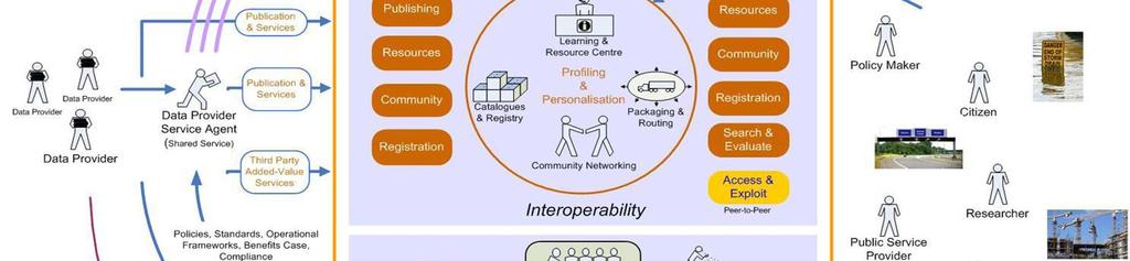
12 UKLII Technical Architecture overview Key to numbers: Data Publisher Registration (1) Metadata Registration (2, 3, 4) Metadata Catalogue Publication (5, 6, 7) Discovering Datasets (8, 9, 10) Accessing Datasets (11, 12, 13)
13 UKLII Discovery Metadata Service (DMS) UKL Metadata Editor tool and metadata creation: create dataset and service metadata. Publish to CSW or WAF (Web Accessible Folder) Data Publisher registration create Data Publisher account on data.gov.uk Metadata registration and harvesting: Register metadata resources on data.gov.uk Metadata harvest by data.gov.uk


14 Content
15 UKLII Data and Service Publishing Metadata catalogue publication to EC and other portals: Extract from data.gov.uk to Catalogue Publication Service (CPS) EU harvest from Catalogue Publication Service via CSW interface Other applications able to access metadata through CPS
 evaluate")
16 UKLII Search and Evaluation Discovering datasets on data.gov.uk discover dataset and service metadata via standard search geographic search using Search Map Widget (client) evaluate datasets using Evaluate Map Widget (client) for View Services


17 Content 17
 Download Services: Direct Access (WFS); simple file download (not yet developed) Transformation")
18 UKLII Access and Exploitation Accessing datasets via data.gov.uk Data Publisher View Services (WMS) Download Services: Direct Access (WFS); simple file download (not yet developed) Transformation Services: Coordinate and Schema transformation (not yet developed) Spatial Data Services??
19 UKLII Other components Technical components on data.gov.uk: Registry; User and Data Publisher Account management Community Networking on data.gov.uk: apps; ideas; blogs; wiki; forum Supporting Services Ordnance Survey mapping service Ordnance Survey gazetteer service
20 Integration issues Standards the great thing about standards is that there are so many to choose from Metadata: UKLII uses UK GEMINI21; Data.gov.uk part based on e-gms (e-gif). > Catalogue search issue. Map across Data: UKLII requires interoperable datasets (INSPIRE Regulations); Data.gov.uk requires datasets in re-usable form. > Data processing issue Data Quality UKLII: comprehensive metadata and data validation (e.g schematron; schemas); Data.gov.uk: limited QA of content. > Variation in quality
21 Integration issues Portal functionality UKLII: requires harvesting, spatial search, visual evaluation, catalogue publishing, WFS download, transformation, reporting etc; Data.gov.uk: upload, search, evaluate, download. > extend portal functionality and processes Licensing and charging UKLII: includes charged for data, commercial and 3 rd sector. Data.gov.uk uses Open Government Licence (OGL). > amend site T&Cs; reposition data.gov.uk. Terminology/Actors UKLII: has Data Providers, Data Publishers, & Data Users. Data.gov.uk: Data Provider = Data Publisher. > adjust signposting and navigation
22 Integration issues Audience/Users UKLII: deals with location (spatial) data. Data.gov.uk deals primarily with non-spatial data. > broaden site orientation and adjust guidance Development and Support Development approach (Waterfall vs. AGILE); Development timetable (INSPIRE vs. Transparency vs. Business); Customer support. > adjust and integrate
23 Benefits of integration/single UK portal Data.gov.uk capability: search capability and scalability community networking capability - support developers/users high visibility/major presence on the web Wider benefits: meets principle of reusing what already exists - costs helps minimise the number of portals - one place to go aligns with a key government policy Transparency bringing closer working with Cabinet Office and between Location people and wider Information domain people and expected greater benefit in exploiting spatial and non-spatial data together
24 Lessons learnt Technical infrastructure being delivered at relatively low cost Integrating development work between all the parties is a challenge planning and control Design changes risk delays (v.3.0 Tech.Guidance) Maintain good working relationships A lot of expertise required needs maintaining Keep language simple naming and jargon a typical IT project? but INSPIRE is a world first and there s no manual!


25 Conclusion: UKLII + data.gov.uk A happy marriage with the odd difference of opinion but mostly a learning process
26 Resources Where can I find out more? UK Location website Data.gov.uk Who to contact? UK Location Coordination Center Rod Kedge, UK Location r.kedge@ccw.gov.uk
The Scottish Spatial Data Infrastructure (SSDI)
") The Scottish Spatial Data Infrastructure (SSDI) INSPIRE Conference Istanbul Monday 25 th June 2012 15:55 Geoportals and registries II Tim Duffy BGS Edinburgh (trd@bgs.ac.uk) Shona Nicol Alex Ramage NERC
The Scottish Spatial Data Infrastructure (SSDI) INSPIRE Conference Istanbul Monday 25 th June 2012 15:55 Geoportals and registries II Tim Duffy BGS Edinburgh (trd@bgs.ac.uk) Shona Nicol Alex Ramage NERC
How to Register where a Brownfield Land Register has been published.
 How to Register where a Brownfield Land Register has been published. Version 3 Date 21/12/2017 Contents About this guide 1 Why register the location of a published file? 2 The CSV file 2 Spatial files
Metadata for Data Discovery: The NERC Data Catalogue Service. Steve Donegan
 Metadata for Data Discovery: The NERC Data Catalogue Service Steve Donegan Introduction NERC, Science and Data Centres NERC Discovery Metadata The Data Catalogue Service NERC Data Services Case study:
The European Commission s science and knowledge service. Joint Research Centre
 The European Commission s science and knowledge service Joint Research Centre GeoDCAT-AP The story so far Andrea Perego, Antonio Rotundo, Lieven Raes GeoDCAT-AP Webinar 6 June 2018 What is GeoDCAT-AP Geospatial
INSPIRE & Environment Data in the EU
 INSPIRE & Environment Data in the EU Andrea Perego Research Data infrastructures for Environmental related Societal Challenges Workshop @ pre-rda P6 Workshops, Paris 22 September 2015 INSPIRE in a nutshell
INSPIRE status report
 INSPIRE Team INSPIRE Status report 29/10/2010 Page 1 of 7 INSPIRE status report Table of contents 1 INTRODUCTION... 1 2 INSPIRE STATUS... 2 2.1 BACKGROUND AND RATIONAL... 2 2.2 STAKEHOLDER PARTICIPATION...
GeoDCAT-AP Representing geographic metadata by using the "DCAT application profile for data portals in Europe"
 GeoDCAT-AP Representing geographic metadata by using the "DCAT application profile for data portals in Europe" Andrea Perego, Vlado Cetl, Anders Friis-Christensen, Michael Lutz, Lorena Hernandez Joint
Initial Operating Capability & The INSPIRE Community Geoportal
 INSPIRE Conference, Rotterdam, 15 19 June 2009 1 Infrastructure for Spatial Information in the European Community Initial Operating Capability & The INSPIRE Community Geoportal EC INSPIRE GEOPORTAL TEAM
PDOK. Part of the Dutch SDI, growing from portal to platform. Haico van der Vegt Strategic Advisor Kadaster
 PDOK Part of the Dutch SDI, growing from portal to platform Haico van der Vegt Strategic Advisor Kadaster PDOK public services on the map Geo-webservices distribution portal E-Government initiative Open,
Innovation Infrastructure Partnership
 Innovation Infrastructure Partnership Vision The Innovation Infrastructure Partnership s vision is to support the creation, adoption and commercialisation of new technologies, helping UK companies to gain
Toward Horizon 2020: INSPIRE, PSI and other EU policies on data sharing and standardization
 Toward Horizon 2020: INSPIRE, PSI and other EU policies on data sharing and standardization www.jrc.ec.europa.eu Serving society Stimulating innovation Supporting legislation The Mission of the Joint Research
Introduction to INSPIRE. Network Services
 Introduction to INSPIRE. Network Services European Commission Joint Research Centre Institute for Environment and Sustainability Digital Earth and Reference Data Unit www.jrc.ec.europa.eu Serving society
Integration of INSPIRE & SDMX data infrastructures for the 2021 population and housing census
 Integration of INSPIRE & SDMX data infrastructures for the 2021 population and housing census Nadezhda VLAHOVA, Fabian BACH, Ekkehard PETRI *, Vlado CETL, Hannes REUTER European Commission (*ekkehard.petri@ec.europa.eu
The UK Marine Environmental Data and Information Network MEDIN
 The UK Marine Environmental Data and Information Network MEDIN M. Charlesworth, R. Lowry, H. Freeman, J. Rapaport, B Seeley Content MEDIN - a brief overview for context Discovery Metadata Standard and
Validation experience
 Validation experience Paloma Abad Head of SDI Department SDI Workshop 26-06-2018 INSPIRE KEN INSPIRE KEN, june 2018 1 Points 1. Introduction 2. Interoperability 3. Geoportal Thematic Viewer 4. Conclusions
Compass INSPIRE Services. Compass INSPIRE Services. White Paper Compass Informatics Limited Block 8, Blackrock Business
 Compass INSPIRE Services White Paper 2010 Compass INSPIRE Services Compass Informatics Limited Block 8, Blackrock Business Park, Carysfort Avenue, Blackrock, County Dublin, Ireland Contact Us: +353 1 2104580
For each use case, the business need, usage scenario and derived requirements are stated. 1.1 USE CASE 1: EXPLORE AND SEARCH FOR SEMANTIC ASSESTS
 1 1. USE CASES For each use case, the business need, usage scenario and derived requirements are stated. 1.1 USE CASE 1: EXPLORE AND SEARCH FOR SEMANTIC ASSESTS Business need: Users need to be able to
Semantic Interoperability of Basic Data in the Italian Public Sector Giorgia Lodi
 Semantic Interoperability of Basic Data in the Italian Public Sector Giorgia Lodi SEMIC conference 2013 21 June 2013 Dublin (AgID) Created last year, AgID is a public body that merged three different existing
Evolution of INSPIRE interoperability solutions for e-government
 Evolution of INSPIRE interoperability solutions for e-government INSPIRE Implementation State-of-Play 26/05/2015 Robin S. Smith www.jrc.ec.europa.eu Serving society Stimulating innovation Supporting legislation
Next Generation Strategy
 Realising the Benefits of Next Generation Access for Northamptonshire Superfast Northamptonshire: Next Generation Strategy Executive Summary Extending access to superfast broadband - A Consultation Contents
The French Geoportal : linking discovery and view network services. INSPIRE Conference Krakow
 The French Geoportal : linking discovery and view network services ( BRGM ) D.Richard (IGN) F. Robida Context of the French Geoportal The governance mechanism Transversal organisation based on the Ministry
SAFER the GIGAS Effect
 SAFER the GIGAS Effect How INSPIRE, GMES and GEOSS are influencing EC projects Arnaud Cauchy 23/06/2010 Agenda GIGAS Project Summary SAFER Project Summary SAFER Original Approach GIGAS Influences SAFER
Making Open Data work for Europe
 Making Open Data work for Europe Daniele Rizzi European Commission DG Communications Networks, Content and Technology daniele.rizzi@ec.europa.eu Nikolaos Loutas PwC EU Services nikolaos.loutas@be.pwc.com
Promoting semantic interoperability between public administrations in Europe
 ISA solutions, Brussels, 23 September 2014 Vassilios.Peristeras@ec.europa.eu Promoting semantic interoperability between public administrations in Europe What semantics is about? ISA work in semantics
MY DEWETRA IPAFLOODS REPORT
 Grant Contract N. ECHO/SUB/2014/692292 Programme for Prevention, Preparedness and Response to Floods in the Western Balkans and Turkey IPA FLOODS Capacity Building Activities 2016 MY DEWETRA IPAFLOODS
Call for Participation in AIP-6
 Call for Participation in AIP-6 GEOSS Architecture Implementation Pilot (AIP) Issue Date of CFP: 9 February 2013 Due Date for CFP Responses: 15 March 2013 Introduction GEOSS Architecture Implementation
/// INTEROPERABILITY BETWEEN METADATA STANDARDS: A REFERENCE IMPLEMENTATION FOR METADATA CATALOGUES
 /// Position Paper /// INTEROPERABILITY BETWEEN METADATA STANDARDS: A REFERENCE IMPLEMENTATION FOR METADATA CATALOGUES /// Keywords: Public administration, Metadata, Geographical Information, Geospatial
22 September Urban Modelling. using Open Public. Data. Börkur Sigurbjörnsson Data
 22 September 2016 Urban Modelling using Open Public Data Börkur Sigurbjörnsson Data Scientist @borkurdotnet Future Cities Catapult A global centre of excellence on urban innovation. http://futurecities.catapult.org.uk/
Experience federating the metadata catalogue of IGN in the Spanish Open Data Portal
 Experience federating the metadata catalogue of IGN in the Spanish Open Data Portal Paloma Abad E. López, A.F. Rodríguez, A. Sánchez, S. Castro, S. Soriano, J.I Sánchez 1 Summary IGN Metadata Catalogue
Promoting accountability and transparency of multistakeholder partnerships for the implementation of the 2030 Agenda
 2016 PARTNERSHIP FORUM Promoting accountability and transparency of multistakeholder partnerships for the implementation of the 2030 Agenda 31 March 2016 Dialogue Two (3:00 p.m. 5:45 p.m.) ECOSOC CHAMBER,
A Thematic Approach to Data Management and Implementation of INSPIRE: The UK Marine Environmental Data and Information Network
 A Thematic Approach to Data Management and Implementation of INSPIRE: The UK Marine Environmental Data and Information Network Mark Charlesworth mecha@bodc.ac.uk www.oceannet.org Content Importance marine
ENISA EU Threat Landscape
 ENISA EU Threat Landscape 24 th February 2015 Dr Steve Purser ENISA Head of Department European Union Agency for Network and Information Security www.enisa.europa.eu Agenda ENISA Areas of Activity Key
1. CONCEPTUAL MODEL 1.1 DOMAIN MODEL 1.2 UML DIAGRAM
 1 1. CONCEPTUAL MODEL 1.1 DOMAIN MODEL In the context of federation of repositories of Semantic Interoperability s, a number of entities are relevant. The primary entities to be described by ADMS are the
National Data Sharing and Accessibility Policy-2012 (NDSAP-2012)
") National Data Sharing and Accessibility Policy-2012 (NDSAP-2012) Department of Science & Technology Ministry of science & Technology Government of India Government of India Ministry of Science & Technology
National Data Sharing and Accessibility Policy-2012 (NDSAP-2012) Department of Science & Technology Ministry of science & Technology Government of India Government of India Ministry of Science & Technology
Accelerate Your Enterprise Private Cloud Initiative
 Cisco Cloud Comprehensive, enterprise cloud enablement services help you realize a secure, agile, and highly automated infrastructure-as-a-service (IaaS) environment for cost-effective, rapid IT service
SECTION 10 EXCHANGE PROTOCOL
 SECTION 10 EXCHANGE PROTOCOL The ADMS specification will facilitate the creation of a federation of disparate semantic asset repositories at the EU level. This federation will consist of Joinup setting
 http://ipafloods.mydewetra.org 1 My Dewetra IPA FLOODS FLOOD RISK Information System Support the Approximation of EU Floods Directive Compliancy with International standards (INSPIRE, OGC) and protocols
INSPIRE in a nutshell, and overview of the European Union Location Framework
 INSPIRE in a nutshell, and overview of the European Union Location Framework Francesco Pignatelli European Commission, DG JRC 10 th European Congress and Exhibition on Intelligent Transport Systems and
Multi-disciplinary Interoperability: the EuroGEOSS Operating Capacities
 Multi-disciplinary Interoperability: the EuroGEOSS Operating Capacities Stefano Nativi (CNR) stefano.nativi@cnr.it Opening and context for Global Dimension Stream: EuroGEOSS contribution to the Global
Interoperability and transparency The European context
 JOINING UP GOVERNMENTS EUROPEAN COMMISSION Interoperability and transparency The European context ITAPA 2011, Bratislava Francisco García Morán Director General for Informatics Background 2 3 Every European
Accelerating Cloud Adoption
 Accelerating Cloud Adoption Ron Stuart July 2016 Disruption Disruption is the new normal Globally interconnected, convenient and more efficient than ever before NZ Government challenge is to use disruptive
The U.S. National Spatial Data Infrastructure
 June 18, 2014 INSPIRE Conference 2014 The U.S. National Spatial Data Infrastructure past present and future Ivan B. DeLoatch Executive Director, Federal Geographic Data Committee U.S. Geological Survey
INSPIRE: The ESRI Vision. Tina Hahn, GIS Consultant, ESRI(UK) Miguel Paredes, GIS Consultant, ESRI(UK)
 Miguel Paredes, GIS Consultant, ESRI(UK)") INSPIRE: The ESRI Vision Tina Hahn, GIS Consultant, ESRI(UK) Miguel Paredes, GIS Consultant, ESRI(UK) Overview Who are we? Introduction to ESRI Inc. and ESRI(UK) Presenters ArcGIS The ESRI Solution to
INSPIRE: The ESRI Vision Tina Hahn, GIS Consultant, ESRI(UK) Miguel Paredes, GIS Consultant, ESRI(UK) Overview Who are we? Introduction to ESRI Inc. and ESRI(UK) Presenters ArcGIS The ESRI Solution to
Telecommunications Strategy
 Telecommunications Strategy Mike Rudd Telecommunications Strategy Manager June 27, 2017 http://www.gov.uk/ukspaceagency Me! Joined UKSA in Aug 16 Career Civil Servant Remit Telecommunications Strategy
IN THE FRAME. Computacenter Public Sector Frameworks FRAMEWORK
 IN THE FRAME Computacenter Public Sector Frameworks FRAMEWORK SOLUTION PUBLIC SECTOR FRAMEWORK ACCELERATE TRANSFORMATION Put digitalisation in the fast lane with cost-effective, compliant and centralised
INSPIRE Geoportal Rich user experience across member states services
 INSPIRE Geoportal Rich user experience across member states services developed under a contract with the EC (JRC) Diomede ILLUZZI 1 Nicola LUNANOVA 1 Torsten FRIEBE 2 1 Planetek Italia s.r.l Via Masaua
Reducing Consumer Uncertainty
 Spatial Analytics Reducing Consumer Uncertainty Towards an Ontology for Geospatial User-centric Metadata Introduction Cooperative Research Centre for Spatial Information (CRCSI) in Australia Communicate
National Geographic Institute
 National Geographic Institute National Center for Geographic Information A specific website for metadata in Spain: MD Geoportal Alejandra Sánchez Maganto A.F.Rodríguez, P. Abad, E. López, M. Juanatey,
Understanding and Using Metadata in ArcGIS. Adam Martin Marten Hogeweg Aleta Vienneau
 Understanding and Using Metadata in ArcGIS Adam Martin Marten Hogeweg Aleta Vienneau Adam Martin National Government Account Management R&D Open Data Marten Hogeweg National Government Professional Services
SDI and the Key Elements
 SDI and the Key Elements Roger Longhorn Information Policy Advisor, The Coastal & Marine Union (EUCC) Senior Information Policy Analyst & Principal SDI Expert, Compass Informatics Ltd (Ireland) (www.compass.ie)
Ambiguities in the Implementation of the INSPIRE directive for Metadata. J.Walther, F.Schenk
 Ambiguities in the Implementation of the INSPIRE directive for Metadata J.Walther, F.Schenk Errors and Ambiguities e.g. UseLimitation INSPIRE Metadata Implementing Rules: Technical Guidelines based on
CMS to Service Portal
 CMS to Service Portal 02.28.2018 Introduction Interested in today s presentation? Text 408.335.7772 0228 Introduction ServiceNow Partner since 2011 Executed more than 400+ ServiceNow Implementations (small
Leveraging metadata standards in ArcGIS to support Interoperability. Aleta Vienneau and Marten Hogeweg
 Leveraging metadata standards in ArcGIS to support Interoperability Aleta Vienneau and Marten Hogeweg Leveraging metadata standards in ArcGIS to support Interoperability Overview of metadata standards
ESFRI Strategic Roadmap & RI Long-term sustainability an EC overview
 ESFRI Strategic Roadmap & RI Long-term sustainability an EC overview Margarida Ribeiro European Commission DG Research & B.4 - Research Infrastructure Research and What is ESFRI? An informal body composed
The cadastral data and standards based on XML in Poland
 The cadastral data and standards based on XML in Poland Jarosław Bydłosz, Piotr Parzych AGH University of Science and Technology Cracow, Poland 1 XML XML Extensible Markup Language Extensible Markup Language
NATIONAL GEOPORTAL USER GUIDE
 NATIONAL GEOPORTAL USER GUIDE National Spatial Data Management Division January 2016 TABLE OF CONTENTS GENERAL OVERVIEW... 1 ABOUT THIS MANUAL... 2 ACCESSING THE GEOPORTAL... 3 ADDING DATA TO THE GEOPORTAL...
Sub-national dimensions of INSPIRE
 www.eurogeographics.org CONNECTING YOU TO THE Sub-national dimensions of INSPIRE SDIs in the evolving EU society Dave Lovell, Secretary General and Executive Director 24 June 2013 Copyright 2013 EuroGeographics
Data Warehousing Fundamentals by Mark Peco
 Data Warehousing Fundamentals by Mark Peco All rights reserved. Reproduction in whole or part prohibited except by written permission. Product and company names mentioned herein may be trademarks of their
Advanced Grid Technologies, Services & Systems: Research Priorities and Objectives of WP
 Advanced Grid Technologies, Services & Systems: Research Priorities and Objectives of WP 2005-06 06 IST Call 5 Preparatory Workshop Brussels, 31 Jan 1 Feb 2005 Enabling application Max Lemke Deputy Head
INSPIRE tools What's new?
 INSPIRE tools What's new? Michael Lutz INSPIRE Conference, Antwerp 18 September 2018 Joint Research Centre The European Commission s science and knowledge service INSPIRE reference validator Why a reference
Metadata of geographic information
 Metadata of geographic information Kai Koistinen Management of environmental data and information 4.10.2017 Topics Metadata of geographic information What is metadata? Metadata standards and recommendations
Draft INSPIRE Implementing Rule on Metadata
 Document: D/GIS/97/EN Original Meeting of the Working Party "Geographical Information Systems for Statistics" Joint meeting with National Statistical Offices and National Mapping Agencies Luxembourg, March
Click to edit Master title style
 Land Registry Open Data Click to edit Master title Fuelling the Knowledge Based Economy Click to edit Master subtitle Dr Andrew Trigg Head of Data Strategy HM Land Registry England & Wales andrew.trigg@landregistry.gsi.gov.uk
Detailed analysis + Integration plan
 Outline Integration methodology Detailed analysis + Integration plan Conclusions 2 Outline Integration methodology Detailed analysis + Integration plan Conclusions 3 EULF-ISA Integration: methodology Phase
Transport Technology Connecting Australians. National Intelligent Transport Systems Strategy
 Transport Technology Connecting Australians National Intelligent Transport Systems Strategy 2010-2015 July 2010 (This page intentionally blank) Transport Technology Connecting Australians National Intelligent
Manchester Metropolitan University Information Security Strategy
 Manchester Metropolitan University Information Security Strategy 2017-2019 Document Information Document owner Tom Stoddart, Information Security Manager Version: 1.0 Release Date: 01/02/2017 Change History
The geospatial metadata catalogue. FOSS4G Barcelona. Jeroen Ticheler. Founder and chair. Director
 The geospatial metadata catalogue FOSS4G2010 - Barcelona Jeroen Ticheler Director Founder and chair GeoNetwork opensource Dutch National Geo Registry FAO GeoNetwork SwissTopo geocat.ch GeoNetwork history
National Science and Technology Council. Interagency Working Group on Digital Data
 National Science and Technology Council Interagency Working Group on Digital Data 1 Interagency Working Group White House Executive Office of the President Office of Science and Technology Policy National
Digital repositories as research infrastructure: a UK perspective
 Digital repositories as research infrastructure: a UK perspective Dr Liz Lyon Director This work is licensed under a Creative Commons Licence Attribution-ShareAlike 2.0 UKOLN is supported by: Presentation
CREATING SMART TRANSPORT SERVICES BY FACILITATING THE RE-USE OF OPEN GIS DATA
 OPEN TRANSPORT NET TOMAS MILDORF 16 JUNE 2014 INSPIRE CONFERENCE 2014, AALBORG, DENMARK CREATING SMART TRANSPORT SERVICES BY FACILITATING THE RE-USE OF OPEN GIS DATA 2 1 OTN AT A GLANCE Full title OpenTransportNet
DATA SHARING AND DISCOVERY WITH ARCGIS SERVER GEOPORTAL EXTENSION. Clive Reece, Ph.D. ESRI Geoportal/SDI Solutions Team
 DATA SHARING AND DISCOVERY WITH ARCGIS SERVER GEOPORTAL EXTENSION Clive Reece, Ph.D. ESRI Geoportal/SDI Solutions Team Geoportal Extension for ArcGIS Server Context within an Enterprise Spatial Data Infrastructure
OECD PUBLISHING SERVICES JULY 2014 RELEASE
 OECD PUBLISHING SERVICES JULY 2014 RELEASE OECD ilibrary news what has happened since 2010? The OECD ilibrary has grown a lot since its launch in 2010. In 2011, it reached 3.5 million downloads. This number
Addressing the Barriers to IPv6 Adoption - Barriers to IPv6 Adoption: Overview and Categories
 Addressing the Barriers to IPv6 Adoption - Barriers to IPv6 Adoption: Overview and Categories Mark McFadden IPv6 Framework for European Governments SMART 2016/0099 Workshop I 24 May 2018 Plum Consulting,
Media (NEM) Initiative
 Initiative") Networked and Electronic Media (NEM) Initiative NEM Initiative and involvement of Game developers Possibilities for participation in the new EU funding work programme 2011 Dr.-Ing. Halid Hrasnica Eurescom
Networked and Electronic Media (NEM) Initiative NEM Initiative and involvement of Game developers Possibilities for participation in the new EU funding work programme 2011 Dr.-Ing. Halid Hrasnica Eurescom
Implementing the Army Net Centric Data Strategy in a Service Oriented Environment
 Implementing the Army Net Centric Strategy in a Service Oriented Environment Michelle Dirner Army Net Centric Strategy (ANCDS) Center of Excellence (CoE) Service Team Lead RDECOM CERDEC SED in support
Esri Geoportal Server
 Esri Geoportal Server Implementing a Spatial Data Infrastructure @martenhogeweg Esri Geoportal Server Extending ArcGIS to enable discovery and use of geospatial resources in heterogeneous environments
Workpackage WP 33: Deliverable D33.6: Documentation of the New DBE Web Presence
 Contract n 507953 Workpackage WP 33: Deliverable D33.6: Documentation of the New DBE Web Presence Project funded by the European Community under the Information Society Technology Programme Contract Number:
Action : Streamlining the monitoring and reporting for 2019
 INSPIRE MIWP/2016.2/REVIEW/1.0 Infrastructure for Spatial Information in Europe Action 2016.2: Streamlining the monitoring and reporting for 2019 Review of the Monitoring & Reporting Decision (2009/442/EC)
Open Source
 Open Source Software @EC and EU-FOSSA 2 Marek Przybyszewski and Saranjit Arora DIGIT Directorate-General for European Commission Open Source Summit Europe 2018 Edinburgh, 22-24 October 2018 Agenda Open
INSPIRE overview and possible applications for IED and E-PRTR e- Reporting Alexander Kotsev
 INSPIRE overview and possible applications for IED and E-PRTR e- Reporting Alexander Kotsev www.jrc.ec.europa.eu Serving society Stimulating innovation Supporting legislation The European data puzzle 24
DfT Policy Overview Rod Paterson
 Ports Policy - BPA conference, 3 November 2016 1 DfT Policy Overview Rod Paterson BPA CONFERENCE 18 October 2017 October 17 Plan for my session this morning 1. Update on changes in structures 2. Reflections
New Zealand Government IBM Infrastructure as a Service
 New Zealand Government IBM Infrastructure as a Service A world class agile cloud infrastructure designed to provide quick access to a security-rich, enterprise-class virtual server environment. 2 New Zealand
Workshop 4.4: Lessons Learned and Best Practices from GI-SDI Projects II
 Workshop 4.4: Lessons Learned and Best Practices from GI-SDI Projects II María Cabello EURADIN technical coordinator On behalf of the consortium mcabello@tracasa.es euradin@navarra.es Scope E-Content Plus
New Zealand Government IbM Infrastructure as a service
 New Zealand Government IbM Infrastructure as a service Global leverage / local experts World-class Scalable Agile Flexible Fast Secure What are we offering? IBM New Zealand Government Infrastructure as
One click away from Sustainable Consumption and Production
 SCP CLEARINGHOUSE Sustainable Consumption and Production www.start.scpclearinghouse.org One click away from Sustainable Consumption and Production Convened by Shifting to Sustainable Consumption and Production
FP7-INFRASTRUCTURES Grant Agreement no Scoping Study for a pan-european Geological Data Infrastructure D 4.4
 FP7-INFRASTRUCTURES-2012-1 Grant Agreement no. 312845 Scoping Study for a pan-european Geological Data Infrastructure D 4.4 Report on recommendations for implementation of the EGDI Deliverable number D4.4
Paul Shillcock Transport for London, UK
 Building Information Modeling for Infrastructure Paul Shillcock Transport for London, UK CI3836 The United Kingdom (UK) is experiencing an exponential demand for rail travel, combined with demands from
Bringing EU Cybersecurity & privacy research results closer to the market
 Bringing EU Cybersecurity & privacy research results closer to the market EU-Unity Workshop 11 October 2017, Tokyo, Japan Nicholas Ferguson, Trust-IT Services & Coordinator, Cyberwatching.eu www.cyberwatching.eu
GD 2018/0020 COUNCIL OF MINISTERS RESPONSE TO THE POLICY PRIORITIES & ACTIONS CHIEF MINISTERS WORKING GROUP ON TELECOMMUNICATIONS
 GD 2018/0020 COUNCIL OF MINISTERS RESPONSE TO THE POLICY PRIORITIES & ACTIONS CHIEF MINISTERS WORKING GROUP ON TELECOMMUNICATIONS Background The Chief Minister has a vision that the Isle of Man has a world
Norwegian State of Estate A Reporting Service for the State-owned Properties in Norway
 Norwegian State of Estate A Reporting Service for the State-owned Properties in Norway Ling Shi, Bjørg E. Pettersen, Ivar Østhassel, Nikolay Nikolov, Arash Khorramhonarnama, Arne J. Berre and Dumitru Roman
GeoPortal 4 Everybody
 GeoPortal 4 Everybody Karel Charvát, Jáchym Čepický, Štěpán Kafka, Premysl Vohnout, Martin Vlk Czech Centre for Science and Society Help Service Remote Sensing DT Member What is GeoPortal GeoPortal is
The UK Water Partnership. Business Plan 2018
 The UK Water Partnership Business Plan 2018 Water is essential for the very existence of life; it keeps us and the ecosystems, which we depend on, alive and healthy and is fundamental to our industry,
SEXTANT 1. Purpose of the Application
 SEXTANT 1. Purpose of the Application Sextant has been used in the domains of Earth Observation and Environment by presenting its browsing and visualization capabilities using a number of link geospatial
May 2012 Oracle Spatial User Conference
 1 May 2012 Oracle Spatial User Conference May 23, 2012 Ronald Reagan Building and International Trade Center Washington, DC USA Andrew Howles & Jo Shannon IS Principal Architect General Manager, Operations
ESFRI WORKSHOP ON RIs AND EOSC
 30 January 2019 Royal Geographical Society, London Jan Hrušák From VISION.. to ACTION.. EOSC will provide 1.7m EU researchers an environment with free, open services for data storage, management, analysis
Earth Observation, Climate and Space for Smarter Government
 Earth Observation, Climate and Space for Smarter Government Beth Greenaway, Head of Earth Observation 30 March 2015 http://www.bis.gov.uk/ukspaceagency Overview UK Space Agency EO Importance and priorities
Reducing Consumer Uncertainty Towards a Vocabulary for User-centric Geospatial Metadata
 Meeting Host Supporting Partner Meeting Sponsors Reducing Consumer Uncertainty Towards a Vocabulary for User-centric Geospatial Metadata 105th OGC Technical Committee Palmerston North, New Zealand Dr.
National Cybersecurity Center of Excellence
 National Cybersecurity Center of Excellence Increasing the deployment and use of standards-based security technologies Briefing to ITEA Cyber Workshop 29 March 2017 STRATEGY VISION ADVANCE CYBERSECURITY
Beyond Your Device. Control, Connect, Experience. BT GS Analyst and consultant call 2 July 2013
 Beyond Your Device Control, Connect, Experience BT GS Analyst and consultant call 2 July 2013 Agenda Welcome & situation in the market Neil Sutton, Vice President Portfolio Our solution Connect Jayne Smith,
The One-Ipswich Community
 The One-Ipswich Community Jeff Hume A Recipe for Success Ltd, 44 Felaw Maltings, Ipswich, Suffolk, UK Tel +44 1473 409933 Fax 44 1473 409944 jeff.hume@arfs.co.uk David Field Ipswich Borough Council, Civic