Relation between Geospatial information projects related to GBIF
|
|
|
- Augustine Atkinson
- 6 years ago
- Views:
Transcription
1 Relation between Geospatial information projects related to GBIF Synthesys 3.6-Synthesys 3.7-GBIF.DE- BioGeomancer The most up to date work can always be found at: Javier de la Torre - Jens Fitzke - Patricia Mergen
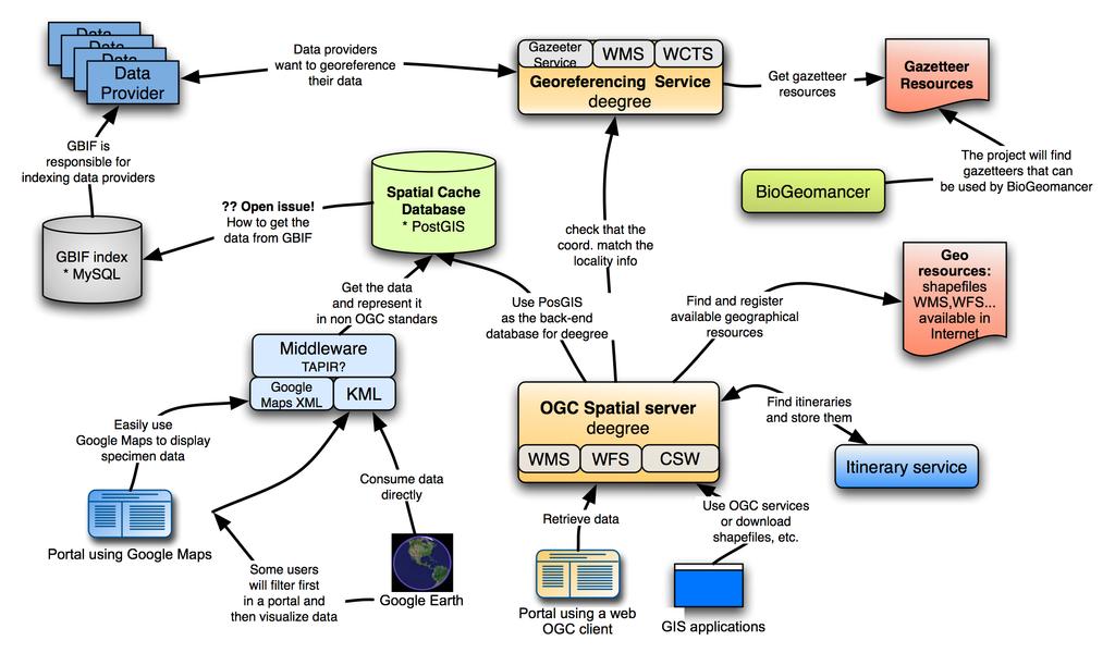
2 Proposed architecture
3 Diagram legend 1 Data Providers: Specimen/observation (unit level) data providers connected to the GBIF network using a BioCASe, Digir or TAPIR wrapper. Digir 2 providers, and pywrapper probably too, will include a little WFS service to provide specimen data in GML.In fact GML for specimen databases (working group in TDWG) could be another view of TAPIR data providers. Spatial cache DB: Database populated with unit data from data providers. It will have spatial index and query capabilities to be able to do spatial searches on it. Can also include some other geographical information, like itineraries. Could maybe be synchronized with GBIF normal cache in some way. Itinerary finder service: The Synthesys 3.7 project tries to identify itineraries in already existing collection datasets. It will retrieve this data from the spatial cache DB, and other sources, and will insert into the spatial cache DB the info about the found itineraries. This will also be related to quality mechanism not described in this document and potentially to BioGeomancer project. The way to describe these itineraries could be GML. This GML format is still not defined. OGC spatial server: This software makes possible to open geographical data trough OGC standards. From the collection of Open Source packages implementing OGC services (Geoserver, UMN, deegree, etc.) deegree was chosen because of the expertise among the partners with it and the more completeness set of available services trough it. WMS: Web Map Service. Maps with distribution of specimens or any other map that can be created using the data available trough deegree. WFS: Web Feature Service. Information about specimens in GML format.
4 Diagram legend 2 NON OGC Services: We think that we have to provide a way to display the data in non standard compliant software like Google services. Google Map Client: A simple interface using Google Maps taking the data from the spatial cache, and optionally layers available. Easy XML: Maybe some other simple formats that could be used in other software (we can consider a TAPIR wrapper here). KML: Keyhole Mark-up Language. To see the data in Google Earth. Portals using an OGC web Client: A web client able to retrieve data from OGC services. Ideally should also be a way for GIS users to filter data on the database, by refining their search and finally be able to see the data in a map and then be able to download it to their GIS application. There is some available software in deegree that Portals can use to implement this. Examples on how to do it will be provided. Georeferencing service: Web, or not web? Interface to help data providers to georeference their specimen data. Somebody like the curator goes to a web page, introduce his wrapper URL, or select it from a list of registered, select a dataset of his database to georeference and runs the service. The Georeferencing Server uses various Gazetteer service instances to georeference the records provided by the user. Gazetteer service: The OGC Gazetteer Service allows a client to retrieve georeferenced wellknown place-name vocabulary from a gazetteer database by using the operations of a Web Feature Service. WCTS: In several point of the architecture here described there will be needs of harmonizing geographical coordinates, for example UTM Spanish grid to decimal coordinates in WGS-84. There is an upcoming standard in OGC for doing this type of transformations.
5 Diagram legend 3 Gazetteer resources: There are gazetteer resources available at different levels, national, European, worldwide, etc. All partners will look for resources and make them available. A Wiki page will be created where people can inform about discovers. GML developed by the Spatial Data Standard TDWG subgroup: GBIF specimen information can be described using GML. There is a subgroup in TDWG working on this. This GML schema should be agreed between all partners, Digir 2 developers and any other project related to GIS use of GBIF data. BioGeomancer: Worldwide collaboration effort to provide a georeferencing framework for natural collections. The scope of this project is much bigger than the one described here in this diagram. Therefore we would like to provide to this project all the resources here available and if possible integrate BioGeomancer services into this infrastructure. Meeting needed to define interfaces. CSW: The OGC Catalog Service 2.0 specification defines a common interface that enables diverse but conformant applications to perform discovery, browse and query operations against distributed and potentially heterogeneous catalog servers. Most commonly a catalog service is used to provide access to metadata about geospatial data and/or geospatial services by exposing an XML/HTTP interface. The underlying database may implement Dublin Core or ISO 19115/19119 metadata elements. Various implementations of the Catalog Service - Web Profile (CSW) exist, among which the deegree catalog service is currently the only open source package available. Geographic resources: As explained this is necessary to do analysis of the data. All partners should try to identify resources freely available. If necessary there is some money in Synthesys 3.6 to buy some good ones for Europe.
6 Diagram legend 4 Google Earth: A pretty impressive software by Google to visualize the world. It has its own geographical laguage called KML, with similar goals as GML, but simpler. XLTs can be considered to transform GML into KML and viceversa GIS applications: There are many. Some of them can consume directly data from OGC compliant services. We may consider three applications as example: Arcview (with Plugin, from ESRI), udig (OpenSource), Diva-GIS (OpenSource), JUMP (Open Source). Portals: Biodiversity informatics portals like GBIF.NET, BioCASE, GBIF.DE, GBIF Spain, etc. They present the unit level data in different ways to different consumers. They may integrate some of the services here described or they will link to them.
7 Open issues Relation between the spatial cache database(s) and the GBIF index: Some kind of synchronization should be considered to avoid data incongruence between them. Also the GBIF index have more powerful capabilities that will make the data more harmonize. The best possibility could be that the spatial database only retrieves data from the GBIF index, not directly from the data providers. The GBIF index database is implemented in MySQL so some software that do incremental updates of the spatial cache database will have to be considered. For project Synthesys 3.6 this is not a high priority and the work will be done in an example dataset of the GBIF index. This relation between the index an the spatial cache database is a wider issue that has to be discussed inside the GBIF community. GML application schema for specimen data: In several services data will be transferred using GML. Therefore we need a GML application schema. There is a subgroup in TDWG called Spatial Data Standards that is working on this.
8 Separation of work between projects GBIF.DE (Uni Bonn, lat/lon) All partners Synthesys 3.6 (Madrid) Synthesys 3.6 (Madrid) Synthesys 3.6 (Madrid) Synthesys 3.7 (Tervuren)
9 Time planning Synthesys 3.6 (Madrid) Synthesys 3. 7 (Tervuren) GBIF.DE (Uni Bonn, lat/lon) BioGeomancer 1/2Nov. Feb. 06 Mar. 06 May. 06 Jun. 06 Nov. 06 Nov. 05 Dec. 06 Report of existing GIS standards and software. Architecture description Spatial cache database in place. If possible degree installed and WMS and WFS services running. - - OGC clients and Non- OGC clients available to be used by portals or other software - - CSW server and load the geographical resources already available to it. Analysis infrastructure for georeference specimens GML developed by TDWG Georeferencing service by GBIF.DE (Bonn University, lat/lon) Analyze ABCD data provided regard to expeditions. Develop algorithms to aggregate unit level data and create itinerary representations Implement demonstrator (web site) for visualizing expeditions based on unit level data in the cache. - BioGeomancer project
10 Links With no special order Deegree: Geoserver: Open Geospatial Consortium: Google Maps: Google Earth: PostGIS: TAPIR: BioGeomancer: Synthesys: Lat/Lon: GBIF.DE: GBIF: GBIF Spain: ArcView: udig: Diva-GIS: BioCASE: TDWG:
Developing a Free and Open Source Software based Spatial Data Infrastructure. Jeroen Ticheler
 Developing a Free and Open Source Software based Spatial Data Infrastructure Jeroen Ticheler 1 License This work is licensed under the Creative Commons Attribution-NonCommercial-ShareAlike 2.5 License.
Introduction to INSPIRE. Network Services
 Introduction to INSPIRE. Network Services European Commission Joint Research Centre Institute for Environment and Sustainability Digital Earth and Reference Data Unit www.jrc.ec.europa.eu Serving society
Metadata for Data Discovery: The NERC Data Catalogue Service. Steve Donegan
 Metadata for Data Discovery: The NERC Data Catalogue Service Steve Donegan Introduction NERC, Science and Data Centres NERC Discovery Metadata The Data Catalogue Service NERC Data Services Case study:
INSPIRE: The ESRI Vision. Tina Hahn, GIS Consultant, ESRI(UK) Miguel Paredes, GIS Consultant, ESRI(UK)
 Miguel Paredes, GIS Consultant, ESRI(UK)") INSPIRE: The ESRI Vision Tina Hahn, GIS Consultant, ESRI(UK) Miguel Paredes, GIS Consultant, ESRI(UK) Overview Who are we? Introduction to ESRI Inc. and ESRI(UK) Presenters ArcGIS The ESRI Solution to
INSPIRE: The ESRI Vision Tina Hahn, GIS Consultant, ESRI(UK) Miguel Paredes, GIS Consultant, ESRI(UK) Overview Who are we? Introduction to ESRI Inc. and ESRI(UK) Presenters ArcGIS The ESRI Solution to
METAINFORMATION INFRASTRUCTURE FOR GEOSPATIAL INFORMATION
 2010/2 PAGES 1 7 RECEIVED 15. 6. 2009 ACCEPTED 2. 3. 2010 T. KLIMENT METAINFORMATION INFRASTRUCTURE FOR GEOSPATIAL INFORMATION ABSTRACT Tomáš KLIMENT email: tomas.kliment@stuba.sk Research field: Spatial
Outline. The Collaborative Research Platform for Data Curation and Repositories: CKAN For ANGIS Data Portal. Open Access & Open Data.
 Outline The Collaborative Research Platform for Data Curation and Repositories: CKAN For ANGIS Data Portal Open Access & Open Data ANGIS data portal New developed features Future works Hsiung-Ming Liao,
The Butterfly Effect. A proposal for distribution and management for butterfly data programs. Dave Waetjen SESYNC Butterfly Workshop May 10, 2012
 The Butterfly Effect A proposal for distribution and management for butterfly data programs Dave Waetjen SESYNC Butterfly Workshop May 10, 2012 http://butterfly.ucdavis.edu Citizen Science based Observation
Compass INSPIRE Services. Compass INSPIRE Services. White Paper Compass Informatics Limited Block 8, Blackrock Business
 Compass INSPIRE Services White Paper 2010 Compass INSPIRE Services Compass Informatics Limited Block 8, Blackrock Business Park, Carysfort Avenue, Blackrock, County Dublin, Ireland Contact Us: +353 1 2104580
Data Standards and Protocols for Biological Collections Data
 Data Standards and Protocols for Biological Collections Data Meeting? Renato De Giovanni CRIA Reference Center on Environmental Information renato @ cria. org. br ICCC12, September 2010 Outline 1. Introduction
An Open Source Software approach to Spatial Data Infraestructures.
 Second Part INSPIRE and SDI: heterogeneous GI accessing solution An Open Source Software approach to Spatial Data Infraestructures. Study of different scenarios Second Part: INDEX I. Intro: SDI: Beginings,
INSPIRE Download Services of the CNIG (Spain) Emilio López Romero
 Emilio López Romero") INSPIRE Download Services of the CNIG (Spain) Emilio López Romero 1 The beginning One day, few years ago, we decided to implement INSPIRE seriously 2 The sources The first step was to identify the available
INSPIRE Download Services of the CNIG (Spain) Emilio López Romero 1 The beginning One day, few years ago, we decided to implement INSPIRE seriously 2 The sources The first step was to identify the available
SEXTANT 1. Purpose of the Application
 SEXTANT 1. Purpose of the Application Sextant has been used in the domains of Earth Observation and Environment by presenting its browsing and visualization capabilities using a number of link geospatial
Leveraging OGC Services in ArcGIS Server. Satish Sankaran, Esri Yingqi Tang, Esri
 Leveraging OGC Services in ArcGIS Server Satish Sankaran, Esri Yingqi Tang, Esri GIS Creating and Managing Geo Information Products - Proprietary - Open Specifications - Standards Dissemination of Geo
DanubeGIS User Manual Document number: Version: 1 Date: 11-Nov-2016
 DanubeGIS User Manual Document number: Version: 1 Date: 11-Nov-2016 Imprint Published by: ICPDR International Commission for the Protection of the Danube River ICPDR 2016 Contact ICPDR Secretariat Vienna
Metadata of geographic information
 Metadata of geographic information Kai Koistinen Management of environmental data and information 4.10.2017 Topics Metadata of geographic information What is metadata? Metadata standards and recommendations
SDI Tecnological Components and Standards
 SDI Tecnological Components and Standards Salvador Bayarri sbayarri@gmail.com World Bank Consultant Contents The SDI architecture model Software components: the SDI stack Basic services Metadata SDI access
Leveraging OGC Services in ArcGIS Server. Satish Sankaran Yingqi Tang
 Leveraging OGC Services in ArcGIS Server Satish Sankaran ssankaran@esri.com Yingqi Tang ytang@esri.com Agenda Interoperability Enablers OGC and esri OGC Web Services ArcGIS and OGC Web Services - @ version
ARCHITECTURE OF SPATIAL DATA INFRASTRUCTURE (SDI) (DRAFT)
 (DRAFT)") ARCHITECTURE OF SPATIAL DATA INFRASTRUCTURE (SDI) (DRAFT) Author: Carlo Cipolloni September 20, 2018 Version 1.0 A SDI platform to support the SEIS in the ENP South region Introduction Based on the Contribution
ARCHITECTURE OF SPATIAL DATA INFRASTRUCTURE (SDI) (DRAFT) Author: Carlo Cipolloni September 20, 2018 Version 1.0 A SDI platform to support the SEIS in the ENP South region Introduction Based on the Contribution
LifeWatch/EnvEurope User Forum Use Case Ecology
 LifeWatch/EnvEurope User Forum Use Case Ecology User Forum Barcelona, March 2012 Michael Mirtl (EAA, Environment Agency Austria) Wouter Los (LifeWatch) Infrastructure for Biodiversity and Ecosystem Research
ArcGIS 9.2 Works as a Complete System
 ArcGIS 9.2 Works as a Complete System A New Way to Manage and Disseminate Geographic Knowledge Author/Serve/Use Maps Data Models Globes Metadata Use Desktop Explorer Web Map Viewer Mobile Open APIs Enterprise
Spatial Data on the Web
 Spatial Data on the Web Tools and guidance for data providers The European Commission s science and knowledge service W3C Data on the Web Best Practices 35 W3C/OGC Spatial Data on the Web Best Practices
The geospatial metadata catalogue. FOSS4G Barcelona. Jeroen Ticheler. Founder and chair. Director
 The geospatial metadata catalogue FOSS4G2010 - Barcelona Jeroen Ticheler Director Founder and chair GeoNetwork opensource Dutch National Geo Registry FAO GeoNetwork SwissTopo geocat.ch GeoNetwork history
The European Commission s science and knowledge service. Joint Research Centre
 The European Commission s science and knowledge service Joint Research Centre GeoDCAT-AP The story so far Andrea Perego, Antonio Rotundo, Lieven Raes GeoDCAT-AP Webinar 6 June 2018 What is GeoDCAT-AP Geospatial
Providing Interoperability Using the Open GeoServices REST Specification
 2013 Esri International User Conference July 8 12, 2013 San Diego, California Technical Workshop Providing Interoperability Using the Open GeoServices REST Specification Satish Sankaran Kevin Sigwart What
Reducing Consumer Uncertainty
 Spatial Analytics Reducing Consumer Uncertainty Towards an Ontology for Geospatial User-centric Metadata Introduction Cooperative Research Centre for Spatial Information (CRCSI) in Australia Communicate
Esri Support for Geospatial Standards
 APRIL 2017 ArcGIS Is Open and Interoperable Esri Support for Geospatial Standards Copyright 2017 Esri All rights reserved. Printed in the United States of America. The information contained in this document
SDI SOLUTIONS FOR INSPIRE: TECHNOLOGIES SUPPORTING A FRAMEWORK OF COOPERATION
 SDI SOLUTIONS FOR INSPIRE: TECHNOLOGIES SUPPORTING A FRAMEWORK OF COOPERATION Roberto Lucchi 1, Marten Hogeweg 1, Guenther Pichler 2 1 Esri, Redlands, CA, USA 2 Esri Kranzberg, Germany 1 Vision INSPIRE
Implementing Web GIS Solutions
 Implementing Web GIS Solutions using open source software Karsten Vennemann Seattle Talk Overview Talk Overview Why and What What is Open Source (GIS)? Why use it? Application Components Overview of Web
gvsig: towards 4D GIS
 gvsig: towards 4D GIS Salvador Bayarri IVER Salvador.Bayarri@iver.es www.gvsig.gva.es Contents gvsig's background & updates 3D visualization in gvsig Time and Animation in gvsig Implementation plan Demo
Multi-disciplinary Interoperability: the EuroGEOSS Operating Capacities
 Multi-disciplinary Interoperability: the EuroGEOSS Operating Capacities Stefano Nativi (CNR) stefano.nativi@cnr.it Opening and context for Global Dimension Stream: EuroGEOSS contribution to the Global
Lecture note on the history and principles of geo-webservices
 A SHORT INTRODUCTION TO GEO-WEBSERVICES Lecture note on the history and principles of geo-webservices Barend Köbben Version 1.0 February 24, 2010 Contents 1 From monolithic to distributed GIS architectures
Web Map Servers. Mark de Blois. Septembre 2016
 Web Map Servers Mark de Blois Septembre 2016 Learning Objectives After this lecture you will be able to understand web map servers as used in Web-GIS applications Introduction A Web Map Server is a computer
International Organization for Standardization Technical Committee 211 (ISO/TC211)
") Esri Support for Geospatial Standards: Open Geospatial Consortium (OGC) International Organization for Standardization Technical Committee 211 (ISO/TC211) An Esri White Paper April 2015 Copyright 2015
Esri Support for Geospatial Standards: Open Geospatial Consortium (OGC) International Organization for Standardization Technical Committee 211 (ISO/TC211) An Esri White Paper April 2015 Copyright 2015
GeoNode Integration with SDIs and Community Mapping
 GeoNode Integration with SDIs and Community Mapping Salvador Bayarri sbayarri@gmail.com World Bank Consultant Contents Accessing other SDI services Catalog harvesting through Geonetwork Cascading external
GeoDCAT-AP Representing geographic metadata by using the "DCAT application profile for data portals in Europe"
 GeoDCAT-AP Representing geographic metadata by using the "DCAT application profile for data portals in Europe" Andrea Perego, Vlado Cetl, Anders Friis-Christensen, Michael Lutz, Lorena Hernandez Joint
GML Application Schema for Meteorological Objects
 GML Application Schema for Meteorological Objects Ilkka Rinne Finnish Meteorological Institute 9 th June 2009, EGOWS meeting, De Bilt, Netherlands Prepare for INSPIRE, Learn OGC Web Services OGC Web Service
The GeoPortal Cookbook Tutorial
 The GeoPortal Cookbook Tutorial Wim Hugo SAEON/ SAEOS SCOPE OF DISCUSSION Background and Additional Resources Context and Concepts The Main Components of a GeoPortal Architecture Implementation Options
How to become an INSPIRE node and fully exploit the investments made?
 How to become an INSPIRE node and fully exploit the investments made? Solution patterns for consumers: end users & developers (2/2) Roberto Lucchi 22 June 2010, Krakow 1 Geoportal extension Enabling discovery
When using this architecture for accessing distributed services, however, query broker and/or caches are recommendable for performance reasons.
 Integration of semantics, data and geospatial information for LTER Abstract The long term ecological monitoring and research network (LTER) in Europe[1] provides a vast amount of data with regard to drivers
The Scottish Spatial Data Infrastructure (SSDI)
") The Scottish Spatial Data Infrastructure (SSDI) INSPIRE Conference Istanbul Monday 25 th June 2012 15:55 Geoportals and registries II Tim Duffy BGS Edinburgh (trd@bgs.ac.uk) Shona Nicol Alex Ramage NERC
The Scottish Spatial Data Infrastructure (SSDI) INSPIRE Conference Istanbul Monday 25 th June 2012 15:55 Geoportals and registries II Tim Duffy BGS Edinburgh (trd@bgs.ac.uk) Shona Nicol Alex Ramage NERC
INSPIRE Geoportal. Jens STUTTE 1, Nicola LUNANOVA 1, Jens FITZKE 2, Torsten FRIEBE 2
 INSPIRE Geoportal The developments made towards the INSPIRE Geoportal at European Level - an overview. Jens STUTTE 1, Nicola LUNANOVA 1, Jens FITZKE 2, Torsten FRIEBE 2 1 Planetek Italia s.r.l Via Masaua
Web apps for INSPIRE: the ELISE Energy pilot example
 Web apps for INSPIRE: the ELISE Energy pilot example 6 September 2017 Authors: Daniele Francioli Giacomo Martirano Maria Teresa Borzacchiello Francesco Pignatelli Outline Overview of the ELISE Energy Pilot
IT Infrastructure for BIM and GIS 3D Data, Semantics, and Workflows
 IT Infrastructure for BIM and GIS 3D Data, Semantics, and Workflows Hans Viehmann Product Manager EMEA ORACLE Corporation November 23, 2017 @SpatialHannes Safe Harbor Statement The following is intended
Jeffery S. Horsburgh. Utah Water Research Laboratory Utah State University
 Advancing a Services Oriented Architecture for Sharing Hydrologic Data Jeffery S. Horsburgh Utah Water Research Laboratory Utah State University D.G. Tarboton, D.R. Maidment, I. Zaslavsky, D.P. Ames, J.L.
The What, Why, Who and How of Where: Building a Portal for Geospatial Data. Alan Darnell Director, Scholars Portal
 The What, Why, Who and How of Where: Building a Portal for Geospatial Data Alan Darnell Director, Scholars Portal What? Scholars GeoPortal Beta release Fall 2011 Production release March 2012 OLITA Award
Interactive Web Mapping: Overview
 Interactive Web Mapping: Overview Overview of how geospatial data is formatted requested supplied consumed by/for web technologies 2 Definitions Analysis exploring and modeling geospatial phenomena Mapping
The GEO Discovery and Access Broker
 WGISS-43 The GEO Discovery and Access Broker S. Nativi (1), M. Santoro (1) (1) Institute of Atmospheric Pollution Research, National Research Council of Italy DOWNSTREAM MIDSTREAM end-users Applications
The coastal data in the regional and national territorial data repertory. Genova 24 Aprile 2012 Anna Cerrato Regione Liguria
 The coastal data in the regional and national territorial data repertory Genova 24 Aprile 2012 Anna Cerrato Regione Liguria www.rndt.gov.it Experience from data providers in using transformation tools
Welcome. to Pre-bid meeting. Karnataka State Spatial Data Infrastructure (KSSDI) Project, KSCST, Bangalore.
 Project, KSCST, Bangalore.") Welcome to Pre-bid meeting Karnataka State Spatial Data Infrastructure (KSSDI) Project, KSCST, Bangalore. DEVELOPMENT OF KARNATAKA STATE SPATIAL DATA INFRASTRUCTURE (KSSDI) PROJECT Objective: To develop
Welcome to Pre-bid meeting Karnataka State Spatial Data Infrastructure (KSSDI) Project, KSCST, Bangalore. DEVELOPMENT OF KARNATAKA STATE SPATIAL DATA INFRASTRUCTURE (KSSDI) PROJECT Objective: To develop
IMPLEMENTATION OF THE ELEMENTS INFRASTRUCTURE IN POLAND OF THE NATIONAL LEVEL METADATA
 IMPLEMENTATION OF THE ELEMENTS OF THE NATIONAL LEVEL METADATA INFRASTRUCTURE IN POLAND Bartosz Kopańczyk, kopanczyk@geoscope.pl Tomasz Kubik, tomasz.kubik@pwr.wroc.pl Paweł Netzel, netzel@meteo.uni.wroc.pl
INSPIRE & Linked Data: Bridging the Gap Part II: Tools for linked INSPIRE data
 Making the Web an Exploratory Place for Geospatial Knowledge INSPIRE & Linked Data: Bridging the Gap Part II: Tools for linked INSPIRE data Michalis Alexakis Spiros Athanasiou Nikos Georgomanolis Giorgos
DATA VALIDATION AGAINST SCHEMA AND SOURCE DATA
 DATA VALIDATION AGAINST SCHEMA AND SOURCE DATA didier.bouteloup@ign.fr; dominique.laurent@ign.fr 3 June 2016 ign.fr Context IGN has performed data validation twice On test INSPIRE data (2013-2014) On ELF
Initial Operating Capability & The INSPIRE Community Geoportal
 INSPIRE Conference, Rotterdam, 15 19 June 2009 1 Infrastructure for Spatial Information in the European Community Initial Operating Capability & The INSPIRE Community Geoportal EC INSPIRE GEOPORTAL TEAM
The French Geoportal : linking discovery and view network services. INSPIRE Conference Krakow
 The French Geoportal : linking discovery and view network services ( BRGM ) D.Richard (IGN) F. Robida Context of the French Geoportal The governance mechanism Transversal organisation based on the Ministry
Consolidation Team INSPIRE Annex I data specifications testing Call for Participation
 INSPIRE Infrastructure for Spatial Information in Europe Technical documents Consolidation Team INSPIRE Annex I data specifications testing Call for Participation Title INSPIRE Annex I data specifications
HMA Standardisation Status
 HMA Standardisation Status GSCB Meeting, 18-19 June 2009, Frascati P.G. Marchetti, ESA Y. Coene, SPACEBEL GSCB Meeting, 18 June 2009 Slide 1 Overview Context and Objectives Evolution of specifications
Basic Principles of MedWIS - WISE interoperability
 Co-ordination committee seminar of the national focal points Basic Principles of MedWIS - WISE interoperability Eduardo García ADASA Sistemas Nice - France Agenda WISE vs MedWIS WISE WISE DS WISE vs WISE
Accessing OGC Services To access OGC WMS and WFS open the service in the directory that you want to consume, and click on either WMS or WFS.
 Using Web Services Web Services Overview This user guide contains instructions on how to consume a range of services through a range of both web based and desktop GIS applications. Web services are a live
user manual GeoViewer DB Netze Fahrweg
 user manual GeoViewer DB Netze Fahrweg Register of Infrastructure Updated: Juli 2018 Release: 1.11.0 Page 1 von 32 Content 1 List of illustrations 3 2 Basics 4 2.1 Components 4 2.1.1 Interfaces 4 2.1.2
Long-term preservation for INSPIRE: a metadata framework and geo-portal implementation
 Long-term preservation for INSPIRE: a metadata framework and geo-portal implementation INSPIRE 2010, KRAKOW Dr. Arif Shaon, Dr. Andrew Woolf (e-science, Science and Technology Facilities Council, UK) 3
POSEIDON, INSPIRE updated citizen science project. Andrej Abramić, Alejandro Garcia Mendoza, Ricardo Haroun Tabraue and José Juan Castro Hernández
 POSEIDON, INSPIRE updated citizen science project Andrej Abramić, Alejandro Garcia Mendoza, Ricardo Haroun Tabraue and José Juan Castro Hernández Programa POSEIDON http://www.programaposeidon.eu Citizen
SMARTERDECISIONS. Geospatial Portal 2013 Open Interoperable GIS/Imagery Services with ERDAS Apollo 2013 and ERDAS Imagine 2013
 Geospatial Portal 2013 Open Interoperable GIS/Imagery Services with ERDAS Apollo 2013 and ERDAS Imagine 2013 Carahsoft Intergraph Government Solutions SMARTERDECISIONS Geospatial Portal 2013 Geospatial
EarthLookCZ as Czech way to GMES
 EarthLookCZ as Czech way to GMES Karel Charvat 1 and Petr Horak 1 1 WirelessInfo, Czech Republic, charvat@wirelessinfo.cz Abstract Global Monitoring for Environment and Security is one of 4 ranges of solutions
Metadata in EuroGEOSS project (WP5 Experience from Slovenia)
") Metadata in EuroGEOSS project (WP5 Experience from Slovenia) Barbara Medved-Cvikl barbara.medved-cvikl@bf.uni-lj University of Ljubljana Biotechnical faculty Agenda Metadata what is it? About the role
Metadata in EuroGEOSS project (WP5 Experience from Slovenia) Barbara Medved-Cvikl barbara.medved-cvikl@bf.uni-lj University of Ljubljana Biotechnical faculty Agenda Metadata what is it? About the role
INSPIRE & Environment Data in the EU
 INSPIRE & Environment Data in the EU Andrea Perego Research Data infrastructures for Environmental related Societal Challenges Workshop @ pre-rda P6 Workshops, Paris 22 September 2015 INSPIRE in a nutshell
Uniform Resource Management
 IST-Africa 2008 Conference Proceedings Paul Cunningham and Miriam Cunningham (Eds) IIMC International Information Management Corporation, 2008 ISBN: 978-1-905824-07-6 Uniform Resource Management Karel
Interoperability and Standards Supports in ArcGIS
 Esri International User Conference San Diego, California Technical Workshops July 26, 2012 Interoperability and Standards Supports in ArcGIS Satish Sankaran, Esri Yingqi Tang, Esri Agenda Esri s participation
Tutorial International Standards. Web Map Server (WMS) & Web Feature Server (WFS) Overview
 & Web Feature Server (WFS) Overview") ISO/TC 211 17 th Plenary & Associated Meetings Berlin, Germany, DIN Institute / 2003-10-31 Advisory Group on Outreach Tutorial International Standards Web Map Server (WMS) & Web Feature Server (WFS) Overview
ISO/TC 211 17 th Plenary & Associated Meetings Berlin, Germany, DIN Institute / 2003-10-31 Advisory Group on Outreach Tutorial International Standards Web Map Server (WMS) & Web Feature Server (WFS) Overview
FDO Data Access Technology at a Glance
 Autodesk Geospatial FDO Data Access Technology at a Glance Work seamlessly with your geospatial data whatever the format 1 The Challenge The growing need for openness and interoperability between traditional
Big Data Earth Observation Standardization elements Codrina Ilie TERRASIGNA TF7/SG5
 Big Data Earth Observation Standardization elements Codrina Ilie TERRASIGNA TF7/SG5 1 Earth Observation standardization intro 2 directions: 1. standardization of the Ground Segment Services: Heterogeneous
Leveraging metadata standards in ArcGIS to support Interoperability. David Danko and Aleta Vienneau
 Leveraging metadata standards in ArcGIS to support Interoperability David Danko and Aleta Vienneau Leveraging Metadata Standards in ArcGIS for Interoperability Why metadata and metadata standards? Overview
THE GEOSS PLATFORM TOWARDS A BIG EO DATA SYSTEM LINKING GLOBAL USERS AND DATA PROVIDERS
 THE PLATFORM TOWARDS A BIG EO DATA SYSTEM LINKING GLOBAL USERS AND DATA PROVIDERS J. Van Bemmelen (1), P. De Salvo (2), M. Santoro (3), P. Mazzetti (3), G. Colangeli (1), S. Nativi (4) (1) European Space
A generic approach to manage metadata standards
 A generic approach to manage metadata standards Barde Julien 1, Edgington Duane 1, Desconnets Jean-Christophe 2 1 Monterey Bay Aquarium Research Institute (MBARI) 2 IRD, US ESPACE, Maison de la télédétection
Esri Support for Geospatial Standards: OGC and ISO/TC211. An Esri White Paper May 2015
 Esri Support for Geospatial Standards: OGC and ISO/TC211 An Esri White Paper May 2015 Copyright 2015 Esri All rights reserved. Printed in the United States of America. The information contained in this
Leveraging metadata standards in ArcGIS to support Interoperability. Aleta Vienneau and Marten Hogeweg
 Leveraging metadata standards in ArcGIS to support Interoperability Aleta Vienneau and Marten Hogeweg Leveraging metadata standards in ArcGIS to support Interoperability Overview of metadata standards
INSPIRE Conference Automatic metadata generation for the Web geo-resources
 INSPIRE Conference 2011 Automatic metadata generation for the Web geo-resources B. Borjas, A.J. Florczyk, F.J. López-Pellicer, J. Nogueras-Iso, F.J. Zarazaga-Soria June 28, 2011. Edinburgh Advanced Information
Spatial Data on the Web
 Spatial Data on the Web Tools and guidance for data providers Clemens Portele, Andreas Zahnen, Michael Lutz, Alexander Kotsev The European Commission s science and knowledge service Joint Research Centre
Leveraging OGC Standards on ArcGIS Server
 Leveraging OGC Standards on ArcGIS Server Satish Sankaran Interoperability and Standards Team James Michel III ESRI Intel Team ArcGIS Server Complete Interoperable Server-Based GIS Desktop Explorer Web
Data Product Catalogue. T. Loubrieu, M. Treguer, G. Maudire, IFREMER
 Data Product Catalogue T. Loubrieu, M. Treguer, G. Maudire, IFREMER High level Scope / Requirements Product definition : result of an action or process (aiming at fulfilling user's demand). For seadatanet
SERVO - ACES Abstract
 1 of 6 12/27/2004 2:33 PM 2 of 6 12/27/2004 2:33 PM Implementing GIS Grid Services for the International Solid Earth Research Virtual Observatory Galip Aydin (1), Marlon Pierce (1), Geoffrey Fox (1), Mehmet
idigbio TCN IT Needs Assessment Results José Fortes, Shari Ellis, Andréa Matsunaga
 idigbio TCN IT Needs Assessment Results José Fortes, Shari Ellis, Andréa Matsunaga idigbio Summit November 29th, 2011 Overall Statistics 15-question survey of institutions in 3 funded TCNs 30 returned
Developing an Advanced Document Based Map Server *
 Proceedings of the 8 th International Conference on Applied Informatics Eger, Hungary, January 27 30, 2010. Vol. 1. pp. 337 344. Developing an Advanced Document Based Map Server * Roberto Giachetta a,
Integrated Map Tool. Overview, Current Status, and Things to Come
 Integrated Map Tool Overview, Current Status, and Things to Come Integrated Mapping and Analysis Tool (IMAT) map widget Integrated Mapping Tool IMAT Reusable components for portrayal, query, analysis,
PortalU, a Tool to Support the Implementation of the Shared Environmental Information System (SEIS) in Germany
 in Germany") European conference of the Czech Presidency of the Council of the EU TOWARDS eenvironment Opportunities of SEIS and SISE: Integrating Environmental Knowledge in Europe http:/www.e-envi2009.org/proceedings/
European conference of the Czech Presidency of the Council of the EU TOWARDS eenvironment Opportunities of SEIS and SISE: Integrating Environmental Knowledge in Europe http:/www.e-envi2009.org/proceedings/
Using Free and Open Source GIS to Automatically Create Standards- Based Spatial Metadata
 Using Free and Open Source GIS to Automatically Create Standards- Based Spatial Metadata Claire Ellul University College London Overview The Problem with Metadata Automation Results Further Work The Problem
Title: Author(s)/Organisation(s): Working Group: References: Quality Assurance: A5.2-D3 [3.7] Information Grounding Service Component Specification
![Title: Author(s)/Organisation(s): Working Group: References: Quality Assurance: A5.2-D3 [3.7] Information Grounding Service Component Specification](/thumbs/80/81830659.jpg "Title: Author(s)/Organisation(s): Working Group: References: Quality Assurance: A5.2-D3 [3.7] Information Grounding Service Component Specification") Title: A5.2-D3 [3.7] Information Grounding Service Component Specification Author(s)/Organisation(s): Ana Belén Antón/ETRA Working Group: Architecture Team/WP05 References: A1.8-D5 User Involvement Document,
Title: A5.2-D3 [3.7] Information Grounding Service Component Specification Author(s)/Organisation(s): Ana Belén Antón/ETRA Working Group: Architecture Team/WP05 References: A1.8-D5 User Involvement Document,
Sharing geographic data across the GEF IW Portfolio: IW:LEARN Web-based GIS
 1 Sharing geographic data across the GEF IW Portfolio: IW:LEARN Web-based GIS 16-22 March 2009 Sean Khan (Project Manager) sean.khan@unep.org Dr. Richard Cooper (Regional Coordinator) richard@iwlearn.org
GeoNetwork: metadata and cataloging French (GeoSource) and Swiss (geocat.ch) experiences
 and Swiss (geocat.ch) experiences") GeoNetwork: metadata and cataloging French (GeoSource) and Swiss (geocat.ch) experiences camptocamp SA / 12. mars 2009 / www.camptocamp.com / info@camptocamp.com Camptocamp, a Franco-Swiss company A Franco-Swiss
GeoNetwork: metadata and cataloging French (GeoSource) and Swiss (geocat.ch) experiences camptocamp SA / 12. mars 2009 / www.camptocamp.com / info@camptocamp.com Camptocamp, a Franco-Swiss company A Franco-Swiss
DATA SHARING AND DISCOVERY WITH ARCGIS SERVER GEOPORTAL EXTENSION. Clive Reece, Ph.D. ESRI Geoportal/SDI Solutions Team
 DATA SHARING AND DISCOVERY WITH ARCGIS SERVER GEOPORTAL EXTENSION Clive Reece, Ph.D. ESRI Geoportal/SDI Solutions Team Geoportal Extension for ArcGIS Server Context within an Enterprise Spatial Data Infrastructure
The Community Data Portal and the WMO WIS
 he Community Data Portal and the WIS Presented by: Michael Burek Progress, metadata architecture, and collaboration in the future Acknowledgments NCAR - Luca Cinquini, Rob Markel, Nathan Willhelmi, Don
Using the Network Common Data Form for storage of atmospheric data
 Using the Network Common Data Form for storage of atmospheric data Maarten Plieger Royal Netherlands Meteorological Institute The NetCDF4 data format (Network Common Data Form) is used within the ADAGUC
County of Los Angeles. Chief Information Office Preferred Technologies for Geographic Information Systems (GIS) Version 2 May 2015
 Version 2 May 2015") County of Los Angeles Chief Information Office Preferred Technologies for Geographic Information Systems (GIS) Version 2 May 2015 CIO Preferred Technologies for GIS This document lists the preferred Geographic
County of Los Angeles Chief Information Office Preferred Technologies for Geographic Information Systems (GIS) Version 2 May 2015 CIO Preferred Technologies for GIS This document lists the preferred Geographic
Esri Geoportal Server
 Esri Geoportal Server Implementing a Spatial Data Infrastructure @martenhogeweg Esri Geoportal Server Extending ArcGIS to enable discovery and use of geospatial resources in heterogeneous environments
Carmenta Server Product Description
 White paper Carmenta Server Product Description Carmenta AB, Tel +46-31-775 57 00, www.carmenta.com P315 121RD, 2010 Carmenta reserves the right to change the specifications at any time and without notice.
Cranfield University School of Applied Sciences. MSc Geographical Information Management Academic Year: 2006/2007. Michael Owonibi
 School of Applied Sciences MSc Geographical Information Management Academic Year: 2006/2007 Michael Owonibi The Development of a Prototype Soils Archive Information System to Publish World Soil Data and
(Geo)DCAT-AP Status, Usage, Implementation Guidelines, Extensions
DCAT-AP Status, Usage, Implementation Guidelines, Extensions") (Geo)DCAT-AP Status, Usage, Implementation Guidelines, Extensions HMA-AWG Meeting ESRIN (Room D) 20. May 2016 Uwe Voges (con terra GmbH) GeoDCAT-AP European Data Portal European Data Portal (EDP): central
(Geo)DCAT-AP Status, Usage, Implementation Guidelines, Extensions HMA-AWG Meeting ESRIN (Room D) 20. May 2016 Uwe Voges (con terra GmbH) GeoDCAT-AP European Data Portal European Data Portal (EDP): central
Presented by Kit Na Goh
 Developing A Geo-Spatial Search Tool Using A Relational Database Implementation of the FGDC CSDGM Model Presented by Kit Na Goh Introduction Executive Order 12906 was issued on April 13, 1994 with the
Statistical Viewer. Coping with the Complexity
 Statistical Viewer Coping with the Complexity Overview What s DataCove and Ghosting EuroStat as a Data Resource DataCove Statistical Viewer The Way from Here to There Conclusions What We Do Data Modelling:
ESRI & Interoperability. David Danko ISO TC 211 Metadata Project Leader OGC Metadata WG Chair ESRI Senior Consultant GIS Standards
 ESRI & Interoperability David Danko ISO TC 211 Metadata Project Leader OGC Metadata WG Chair ESRI Senior Consultant GIS Standards ddanko@esri.com GIS has always required Interoperability Social Factors
Deliverable D3.12. Contract number: OJEU 2010/S Deliverable: D3.12 Author: Igor Antolovic Date: Version: Final
 Deliverable D3.12 Final and public version of the implemented web site with full functionality that hosts all relevant information on the Climate Atlas of the Carpathian Region, including a public download