PUBLICATION OF INSPIRE-BASED AGRICULTURAL LINKED DATA
|
|
|
- Hollie Madeleine Collins
- 6 years ago
- Views:
Transcription

, 27 28 September")
1 This project has received funding from the European Union s Horizon 2020 research and innovation programme under grant agreement No This project is part of BDV PPP PUBLICATION OF INSPIRE-BASED AGRICULTURAL LINKED DATA Raul Palma 1, Tomáš Řezník 2, Karel Charvát 2, Soumya Brahma 1, Dmitrij Kozuch 2, Raitis Berzins 2 1 Poznan Supercomputing and Networking Center, Poland 2 WirelessInfo, Czech Republic Linked Open Data in Agriculture MACS-G20 Workshop in Berlin (Germany), September

2 Motivation Farm management context Multiple activities and stakeholders Multiple applications, tools and devices Multiple data sources, data types and data formats Challenge To combine/integrate those different and heterogeneous data sources in order to make economically and environmentally sound decisions 2


3 Data Integration in relevant projects (context) Data integration challenges have been the focus of relevant projects EU FP7, ICT CIP, SDI4Apps aimed at building a cloudbased framework with open API for data integration focusing on the development of six pilot apps, drawing along the lines of INSPIRE, Copernicus and GEOSS EU FP7, ICT CIP, FOODIE aimed at building an open and interoperable cloud-based platform addressing among others the integration of data relevant to farming production including their geo-spatial dimension, as well as their publication as Linked data. DataBio aims at showcasing the benefits of Big Data technologies in the raw material production from agriculture & others for the bioeconomy industry; deploying an interoperable platform on top of the existing partners infrastructure. DataBio aims at delivering solutions for big data mgmt., including i) the storage and querying of various big data sources; ii) the harmonization and integration of a large variety of data from many sources, using linked data as a federated layer 3


4 Linked data publication in agriculture LD is increasingly becoming a popular method for publishing data on the Web Improves data accessibility by both humans and machines, e.g., for finding, reuse and integration Enables to discover more useful data through the links, and to exploit data with semantic queries Growing number of datasets in the LOD cloud > 1100 by 22nd August 2017 Coverage of the LOD cloud Large cross-domain datasets (dbpedia, freebase, etc.) Domain coverage varies (e.g., large number of datasets in Geography, Government, BioInformatics) What about Agriculture? Only few examples (AGRIS biblio records, AGROVOC thesaurus + other thesaurus like NALT) Farming data? 4


5 Linked data publication process overview Simple set of principles & technologies URI, HTTP, RDF, SPARQL Reference Linked data publication pipelines Involves a set of tasks Datasets identification Model specification Villazón-Terrazas et al. RDF data generation Linking Hyland et al. Exploiting Hausenblas et al. 5


6 Linked data publication technologies overview Used technologies: D2RQ for transforming Relational Databases as Virtual RDF Graphs RDF for the representation of data Farming ontology providing the underlying vocabulary and relations Virtuoso for storing the semantic datasets Silk for discovery of links Sparql for querying semantic data Hslayers NG for visualisation of data Metaphactory for visualisation of data D2RQ 6

 Delivered a web-based solution providing")


7 Datasets identification Goal: to publish linked data from pilots in FOODIE project (available in PostgreSQL database): Precision viticulture (Spain) Delivered a web-based solution providing advisory services in different aspects related to winegrowing, like disease prevention, production estimation or harvesting schedule Open Data for Strategic and Tactical planning (Czech Republic) Delivered two main applications, one for farm telemetry and other for estimation of yield potential 7
 (ii) in line with existing standards and best practices INSPIRE directive is an EU initiative that aims at building a Pan- European spatial data infrastructure (SDI) requiring")
8 Data model for farming data Goal: (i) to define the application vocabulary covering the different categories of information dealt by the farm mgmt. tools/apps (in FOODIE) (ii) in line with existing standards and best practices INSPIRE directive is an EU initiative that aims at building a Pan- European spatial data infrastructure (SDI) requiring EU Member States to make available spatial data, from multiple thematic areas, according to established implementing rules using appropriate services. Based on ISO/OGC standards for geographical information, i.e., ISO series standards Hence, FOODIE data model builds on the INSPIRE specification for agricultural and aquaculture facilities theme - AF (for agricultural data), and the INSPIRE data specification for themes in annex I for for geospatial data *consulted with experts from various institutions, e.g., EU DG JRC, EU Global Navigation Satellite Systems Agency (GSA), Czech Ministry of Agriculture, Global Earth Observation System of Systems (GEOSS), German Kuratorium für 8 Technik und Bauwesen in der Landwirtschaft (KTBL).


9 Data model for farming data INSPIRE data specifications are defined as UML models and are available in different XML-based formats FOODIE extensions on the UML model developed by domain experts* Challenge: Transform model into OWL ontology *consulted with experts from various institutions, e.g., EU DG JRC, EU Global Navigation This document Satellite is part of a Systems project that Agency has received (GSA), funding Czech Ministry of Agriculture, Global Earth Observation from the European System Union s of Horizon Systems 2020 research (GEOSS), and innovation German programme Kuratorium für Technik und Bauwesen reproduced in without der the Landwirtschaft formal approval of the (KTBL). DataBio Management Committee. Find us at 9


 Palma R., Reznik T., Esbri M., Charvat K., Mazurek C.")

10 Transformation from UML model to OWL ontology Followed a semi-automatic approach ShapeChange tool that implements ISO standard rules for mapping ISO geographic information UML models to OWL ontologies. XML schemas, feature catalogs, and RDF/OWL Required different processing tasks: Pre-processing Source model preparation ShapeChange tool configuration: encoding rules; mappings UML classes - OWL elements; namespaces definition Base ontologies fixes (INPSIRE common, ISO series standards) Post-processing tasks Manual fixes in the ontology Manual creation of ontology elements of the base INSPIRE schemas (AF) Palma R., Reznik T., Esbri M., Charvat K., Mazurek C., An INSPIRE-based vocabulary for the publication of Agricultural Linked Data. Proceedings of the OWLED 10 Workshop: OWL Experiences and Directions, collocated with the 14th International Semantic Web Conference (ISWC-2015), Bethlehem PA, USA, October 11-15, 2015


11 Ontology for farming data - overview Top hierarchy ShapeChange output UML featuretypes and datatypes modelled as classes, and their attributes as datatype or object properties UML codelists modelled as classes/concepts, and their attributes as concept members Cardinalities restrictions defined on properties (exactly, min, max) DataType properties ranges defined according to model/mappings Object properties ranges defined according to model/mappings Object properties inverseof defined Datatype hierarchy Codelist hierarchy FeatureType hierarchy 11
12 Ontology for farming data main classes overview For the purposes of FOODIE, we found the lack of a feature on a more detailed level than Site that is already part of the INSPIRE AF data model. Main concept: Plot Represents a continuous area of agricultural land with one type of crop species, cultivated by one user in one farming mode Two kinds of data associated: metadata information agro-related information Next concept: Management Zone Enables a more precise description of the land characteristics in fine-grained area speciesplot Foodie:CropSpecies production INSPIRE-AF:Site foodie:plot containsplot alertplot plotalert foodie:alert containsmanagementzone Foodie:ManagementZone interventionplot Foodie:Intervention zonenutrients Foodie:ProductionType Foodie:SoilNutrients 12
13 Ontology for farming data main classes overview The Intervention is the basic feature type for any kind of (farming) application with explicitly defined geometry, e.g., tillage or pruning. Has multiple indirect associations with different concepts Foodie:Intervention Foodie:Treatme ntpurposevalue is-a Foodie:FormOfT reatmentvalue Foodie:ActiveIngredients treatmentpurpose formoftreatment Foodie:Treatment producttreatment plan Foodie:TreatmentPlan productplan preparationplan ingredientproduct treatmentproduct planproduct Foodie:Product preparationproduct Foodie:ProductPreparation preparation 13

14 RDF data generation D2RQ requires a mapping file (in RDF) specifying how to map the content of a relational database to RDF 14
15 RDF data generation The mapping file also specifies the connection details for the source dataset Based on the mapping file, the database content was dumped to an RDF file The RDF file was then loaded into Virtuoso triplestore 15

16 Linking the generated RDF dataset In order to link the resulting RDF dataset with other datasets, we used Silk, but also had to do some manual entries We found issues in handling large datasets in Silk, specially those accessed via SPARQL endpoint that we cannot control 16
17 Exploiting the Linked Data - querying Sparql endpoint: 17

18 Exploiting the Linked Data search & navigate Faceted search endpoint: 18

19 Exploiting the Linked Data visualisation Map visualisation: 19


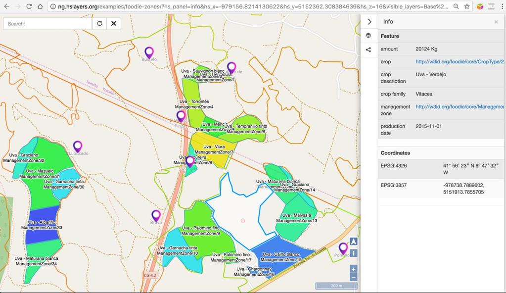
20 Exploiting the Linked Data visualisation Map visualisation: 20


21 Exploiting the Linked Data visualisation Metaphactory: 21

22 Exploiting the Linked Data visualisation Metaphactory: 22
23 Thank you for your attention! Contact details 23
INSPIRE & Environment Data in the EU
 INSPIRE & Environment Data in the EU Andrea Perego Research Data infrastructures for Environmental related Societal Challenges Workshop @ pre-rda P6 Workshops, Paris 22 September 2015 INSPIRE in a nutshell
Introduction to INSPIRE. Network Services
 Introduction to INSPIRE. Network Services European Commission Joint Research Centre Institute for Environment and Sustainability Digital Earth and Reference Data Unit www.jrc.ec.europa.eu Serving society
SEXTANT 1. Purpose of the Application
 SEXTANT 1. Purpose of the Application Sextant has been used in the domains of Earth Observation and Environment by presenting its browsing and visualization capabilities using a number of link geospatial
INSPIRE overview and possible applications for IED and E-PRTR e- Reporting Alexander Kotsev
 INSPIRE overview and possible applications for IED and E-PRTR e- Reporting Alexander Kotsev www.jrc.ec.europa.eu Serving society Stimulating innovation Supporting legislation The European data puzzle 24
The Plan4business Approach to Transfer Open Data into Real Estate Businesses
 The Plan4business Approach to Transfer Open Data into Real Estate Businesses Jan Ježek 1, Tomáš Mildorf 1, Karel Charvát Jr. 2, and Karel Charvát 3 1 University of West Bohemia, Pilsen, Czech Republic
ISA Action 1.17: A Reusable INSPIRE Reference Platform (ARE3NA)
") ISA Action 1.17: A Reusable INSPIRE Reference Platform (ARE3NA) Expert contract supporting the Study on RDF and PIDs for INSPIRE Deliverable D.EC.3.2 RDF in INSPIRE Open issues, tools, and implications
ISA Action 1.17: A Reusable INSPIRE Reference Platform (ARE3NA) Expert contract supporting the Study on RDF and PIDs for INSPIRE Deliverable D.EC.3.2 RDF in INSPIRE Open issues, tools, and implications
CREATING SMART TRANSPORT SERVICES BY FACILITATING THE RE-USE OF OPEN GIS DATA
 OPEN TRANSPORT NET TOMAS MILDORF 16 JUNE 2014 INSPIRE CONFERENCE 2014, AALBORG, DENMARK CREATING SMART TRANSPORT SERVICES BY FACILITATING THE RE-USE OF OPEN GIS DATA 2 1 OTN AT A GLANCE Full title OpenTransportNet
The European Commission s science and knowledge service. Joint Research Centre
 The European Commission s science and knowledge service Joint Research Centre GeoDCAT-AP The story so far Andrea Perego, Antonio Rotundo, Lieven Raes GeoDCAT-AP Webinar 6 June 2018 What is GeoDCAT-AP Geospatial
EarthLookCZ as Czech way to GMES
 EarthLookCZ as Czech way to GMES Karel Charvat 1 and Petr Horak 1 1 WirelessInfo, Czech Republic, charvat@wirelessinfo.cz Abstract Global Monitoring for Environment and Security is one of 4 ranges of solutions
GeoDCAT-AP Representing geographic metadata by using the "DCAT application profile for data portals in Europe"
 GeoDCAT-AP Representing geographic metadata by using the "DCAT application profile for data portals in Europe" Andrea Perego, Vlado Cetl, Anders Friis-Christensen, Michael Lutz, Lorena Hernandez Joint
Jan Bojko Czech Center for Science and Society
 Jan Bojko Czech Center for Science and Society Tomas Mildorf New technologies for the information society University of west bohemia in pilsen, Czech republic Karel Charvat Help Service Remote Sensing,
Study and guidelines on Geospatial Linked Data as part of ISA Action 1.17 Resource Description Framework
 DG Joint Research Center Study and guidelines on Geospatial Linked Data as part of ISA Action 1.17 Resource Description Framework 6 th of May 2014 Danny Vandenbroucke Diederik Tirry Agenda 1 Introduction
INSPIRE & Linked Data: Bridging the Gap Part II: Tools for linked INSPIRE data
 Making the Web an Exploratory Place for Geospatial Knowledge INSPIRE & Linked Data: Bridging the Gap Part II: Tools for linked INSPIRE data Michalis Alexakis Spiros Athanasiou Nikos Georgomanolis Giorgos
EUDAT B2FIND A Cross-Discipline Metadata Service and Discovery Portal
 EUDAT B2FIND A Cross-Discipline Metadata Service and Discovery Portal Heinrich Widmann, DKRZ DI4R 2016, Krakow, 28 September 2016 www.eudat.eu EUDAT receives funding from the European Union's Horizon 2020
Detailed analysis + Integration plan
 Outline Integration methodology Detailed analysis + Integration plan Conclusions 2 Outline Integration methodology Detailed analysis + Integration plan Conclusions 3 EULF-ISA Integration: methodology Phase
INSPIRE: The ESRI Vision. Tina Hahn, GIS Consultant, ESRI(UK) Miguel Paredes, GIS Consultant, ESRI(UK)
 Miguel Paredes, GIS Consultant, ESRI(UK)") INSPIRE: The ESRI Vision Tina Hahn, GIS Consultant, ESRI(UK) Miguel Paredes, GIS Consultant, ESRI(UK) Overview Who are we? Introduction to ESRI Inc. and ESRI(UK) Presenters ArcGIS The ESRI Solution to
INSPIRE: The ESRI Vision Tina Hahn, GIS Consultant, ESRI(UK) Miguel Paredes, GIS Consultant, ESRI(UK) Overview Who are we? Introduction to ESRI Inc. and ESRI(UK) Presenters ArcGIS The ESRI Solution to
Semantic challenges in sharing dataset metadata and creating federated dataset catalogs
 Linked Open Data in Agriculture MACS-G20 Workshop in Berlin, September 27th 28th, 2017 Semantic challenges in sharing dataset metadata and creating federated dataset catalogs The example of the CIARD RING
geospatial querying ApacheCon Big Data Europe 2015 Budapest, 28/9/2015
 geospatial querying in ApacheCon Big Data Europe 2015 Budapest, 28/9/2015 Who am I? Sergio Fernández @wikier http://linkedin.com/in/sergiofernandez http://www.wikier.org Partner Technology Manager at Redlink
Harvesting Open Government Data with DCAT-AP
 Fraunhofer FOKUS Institute for Open Communication Systems AlanDavidRobb / Pixabay (CC0) Harvesting Open Government Data with DCAT-AP Fabian Kirstein, 21. March 2018 The European Data Portal offers more
PROJECT PERIODIC REPORT
 PROJECT PERIODIC REPORT Grant Agreement number: 257403 Project acronym: CUBIST Project title: Combining and Uniting Business Intelligence and Semantic Technologies Funding Scheme: STREP Date of latest
(Geo)DCAT-AP Status, Usage, Implementation Guidelines, Extensions
DCAT-AP Status, Usage, Implementation Guidelines, Extensions") (Geo)DCAT-AP Status, Usage, Implementation Guidelines, Extensions HMA-AWG Meeting ESRIN (Room D) 20. May 2016 Uwe Voges (con terra GmbH) GeoDCAT-AP European Data Portal European Data Portal (EDP): central
(Geo)DCAT-AP Status, Usage, Implementation Guidelines, Extensions HMA-AWG Meeting ESRIN (Room D) 20. May 2016 Uwe Voges (con terra GmbH) GeoDCAT-AP European Data Portal European Data Portal (EDP): central
Metadata for Data Discovery: The NERC Data Catalogue Service. Steve Donegan
 Metadata for Data Discovery: The NERC Data Catalogue Service Steve Donegan Introduction NERC, Science and Data Centres NERC Discovery Metadata The Data Catalogue Service NERC Data Services Case study:
Infrastructure for Spatial Information in Europe. Proposed action for update of MIWP: Alternative encodings for INSPIRE data
 INSPIRE Infrastructure for Spatial Information in Europe Proposed action for update of MIWP: Alternative encodings for INSPIRE data Type Creator MIWP Action fiche DG ENV Date/status/version 20/11/2017
Linked Open Data and Semantic Technologies for Research in Agriculture and Forestry
 Linked Open and Semantic Technologies for Research in Agriculture and Forestry Platform Linked Nederland 2 April 2015 Rob Lokers, Alterra, Wageningen UR Contents related challenges in agricultural (and
Semantic Interoperability of Basic Data in the Italian Public Sector Giorgia Lodi
 Semantic Interoperability of Basic Data in the Italian Public Sector Giorgia Lodi SEMIC conference 2013 21 June 2013 Dublin (AgID) Created last year, AgID is a public body that merged three different existing
Reducing Consumer Uncertainty
 Spatial Analytics Reducing Consumer Uncertainty Towards an Ontology for Geospatial User-centric Metadata Introduction Cooperative Research Centre for Spatial Information (CRCSI) in Australia Communicate
This document is a preview generated by EVS
 TECHNICAL REPORT RAPPORT TECHNIQUE TECHNISCHER BERICHT CEN/TR 15449-5 April 2015 ICS 07.040; 35.240.70 English Version Geographic information - Spatial data infrastructures - Part 5: Validation and testing
Linking and Finding Earth Observation (EO) Data on the Web
 Data on the Web") Linking and Finding Earth Observation (EO) Data on the Web MACS-G20 Workshop: Linked Open Data in Agriculture Berlin, September 27-28, 2017 Dr. Uwe Voges u.voges@conterra.de Introduction Earth Observation
Linking and Finding Earth Observation (EO) Data on the Web MACS-G20 Workshop: Linked Open Data in Agriculture Berlin, September 27-28, 2017 Dr. Uwe Voges u.voges@conterra.de Introduction Earth Observation
Publishing the Norwegian Petroleum Directorate s FactPages as Semantic Web Data
 Publishing the Norwegian Petroleum Directorate s FactPages as Semantic Web Data Martin G. Skjæveland, Espen H. Lian, Ian Horrocks Presented by Evgeny Kharlamov (Oxford University) ISWC, October 24, 2013
Linked Data Practices for the Geospatial Community
 Linked Data Practices for the Geospatial Community Talk subtitle Presented at GEOSS Workshop on Climate Boulder Colorado, 23 September 2011 Stephan Zednik, zednis@rpi.edu RPI / Tetherless World Constellation
Programming technologies supporting management of linked open data in the domain of cereal grain drying and storage
 MACS-G20 Workshop Programming technologies supporting management of linked open data in the domain of cereal grain drying and storage 1/30 Linked Open Data in Agriculture Berlin, September 27 28, 2017
European Location Framework (ELF) acting as a facilitator implementing INSPIRE
 acting as a facilitator implementing INSPIRE") www.eurogeographics.org European Location Framework (ELF) acting as a facilitator implementing INSPIRE Saulius Urbanas, Mick Cory (EuroGeographics) 29 October 2016 Copyright 2013 EuroGeographics EuroGeographics
www.eurogeographics.org European Location Framework (ELF) acting as a facilitator implementing INSPIRE Saulius Urbanas, Mick Cory (EuroGeographics) 29 October 2016 Copyright 2013 EuroGeographics EuroGeographics
Enabling Efficient Discovery of and Access to Spatial Data Services. CHARVAT, Karel, et al. Abstract
 Article Enabling Efficient Discovery of and Access to Spatial Data Services CHARVAT, Karel, et al. Abstract Spatial data represent valuable information and a basis for decision making processes in society.
Metadata of geographic information
 Metadata of geographic information Kai Koistinen Management of environmental data and information 4.10.2017 Topics Metadata of geographic information What is metadata? Metadata standards and recommendations
Uniform Resource Management
 IST-Africa 2008 Conference Proceedings Paul Cunningham and Miriam Cunningham (Eds) IIMC International Information Management Corporation, 2008 ISBN: 978-1-905824-07-6 Uniform Resource Management Karel
INSPIRE status report
 INSPIRE Team INSPIRE Status report 29/10/2010 Page 1 of 7 INSPIRE status report Table of contents 1 INTRODUCTION... 1 2 INSPIRE STATUS... 2 2.1 BACKGROUND AND RATIONAL... 2 2.2 STAKEHOLDER PARTICIPATION...
Methodological Guidelines for Publishing Linked Data
 Methodological Guidelines for Publishing Linked Data Boris Villazón-Terrazas bvillazon@isoco.com @boricles Slides available at: http://www.slideshare.net/boricles/ Acknowledgements: OEG Main References
Semantic Web Fundamentals
 Semantic Web Fundamentals Web Technologies (706.704) 3SSt VU WS 2018/19 with acknowledgements to P. Höfler, V. Pammer, W. Kienreich ISDS, TU Graz January 7 th 2019 Overview What is Semantic Web? Technology
INSPIRE Download Service
 The OGC SOS as INSPIRE Download Service for (meteorological) l) Observation Data Simon Jirka (52 North) 29 th October 2014 5th Workshop on the use of GIS/OGC standards in meteorology Offenbach (Germany)
Big, Linked and Open Earth Observation Data: the Projects TELEIOS and LEO
 Big, Linked and Open Earth Observation Data: the Projects TELEIOS and LEO Manolis Koubarakis Charalampos Nikolaou HELLENIC REPUBLIC National and Kapodistrian University of Athens Introduction TELEIOS:
PortalU, a Tool to Support the Implementation of the Shared Environmental Information System (SEIS) in Germany
 in Germany") European conference of the Czech Presidency of the Council of the EU TOWARDS eenvironment Opportunities of SEIS and SISE: Integrating Environmental Knowledge in Europe http:/www.e-envi2009.org/proceedings/
European conference of the Czech Presidency of the Council of the EU TOWARDS eenvironment Opportunities of SEIS and SISE: Integrating Environmental Knowledge in Europe http:/www.e-envi2009.org/proceedings/
Semantic Web Fundamentals
 Semantic Web Fundamentals Web Technologies (706.704) 3SSt VU WS 2017/18 Vedran Sabol with acknowledgements to P. Höfler, V. Pammer, W. Kienreich ISDS, TU Graz December 11 th 2017 Overview What is Semantic
SCRREEN & the RMIS 2.0
 & the RMIS 2.0 Raw Materials Week Annual Critical Raw Material Event Daniel Cassard - BRGM 07 November 2017, Brussels 730227 knowledge management manages both structured data (from database) and unstructured
The cadastral data and standards based on XML in Poland
 The cadastral data and standards based on XML in Poland Jarosław Bydłosz, Piotr Parzych AGH University of Science and Technology Cracow, Poland 1 XML XML Extensible Markup Language Extensible Markup Language
HUMBOLDT Application Scenario: Protected Areas
 CC by Erlend Schei Copyright by Kecko Copyright by Michael Bezzina CC by Gunnar Ries Copyright by Michael Bezzina Copyright by Michael Bezzina Copyright by Michael Bezzina CC by fs999 CC by Jordan Nielsen
THE ENVIRONMENTAL OBSERVATION WEB AND ITS SERVICE APPLICATIONS WITHIN THE FUTURE INTERNET Project introduction and technical foundations (I)
") ENVIROfying the Future Internet THE ENVIRONMENTAL OBSERVATION WEB AND ITS SERVICE APPLICATIONS WITHIN THE FUTURE INTERNET Project introduction and technical foundations (I) INSPIRE Conference Firenze,
ENVIROfying the Future Internet THE ENVIRONMENTAL OBSERVATION WEB AND ITS SERVICE APPLICATIONS WITHIN THE FUTURE INTERNET Project introduction and technical foundations (I) INSPIRE Conference Firenze,
1. CONCEPTUAL MODEL 1.1 DOMAIN MODEL 1.2 UML DIAGRAM
 1 1. CONCEPTUAL MODEL 1.1 DOMAIN MODEL In the context of federation of repositories of Semantic Interoperability s, a number of entities are relevant. The primary entities to be described by ADMS are the
European Space Policy
 European Space Policy Eleni Paliouras, ESA EuroGeographics General Assembly 3 October 2017 Vienna, Austria ESA UNCLASSIFIED - For Official Use ESA facts and figures Intergovernmental agency of 22 Member
Webinar Annotate data in the EUDAT CDI
 Webinar Annotate data in the EUDAT CDI Yann Le Franc - e-science Data Factory, Paris, France March 16, 2017 This work is licensed under the Creative Commons CC-BY 4.0 licence. Attribution: Y. Le Franc
Serving Ireland s Geospatial as Linked Data on the Web
 Serving Ireland s Geospatial as Linked Data on the Web Dr. Atul Nautiyal ADAPT @ Trinity College Dublin The ADAPT Centre is funded under the SFI Research Centres Programme (Grant 13/RC/2106) and is co-funded
Promoting semantic interoperability between public administrations in Europe
 ISA solutions, Brussels, 23 September 2014 Vassilios.Peristeras@ec.europa.eu Promoting semantic interoperability between public administrations in Europe What semantics is about? ISA work in semantics
Interoperability in Science Data: Stories from the Trenches
 Interoperability in Science Data: Stories from the Trenches Karen Stocks University of California San Diego Open Data for Open Science Data Interoperability Microsoft escience Workshop 2012 Interoperability
The MEG Metadata Schemas Registry Schemas and Ontologies: building a Semantic Infrastructure for GRIDs and digital libraries Edinburgh, 16 May 2003
 The MEG Metadata Schemas Registry Schemas and Ontologies: building a Semantic Infrastructure for GRIDs and digital libraries Edinburgh, 16 May 2003 Pete Johnston UKOLN, University of Bath Bath, BA2 7AY
Automated Visualization Support for Linked Research Data
 Automated Visualization Support for Linked Research Data Belgin Mutlu 1, Patrick Hoefler 1, Vedran Sabol 1, Gerwald Tschinkel 1, and Michael Granitzer 2 1 Know-Center, Graz, Austria 2 University of Passau,
> Semantic Web Use Cases and Case Studies
 > Semantic Web Use Cases and Case Studies Case Study: The Semantic Web for the Agricultural Domain, Semantic Navigation of Food, Nutrition and Agriculture Journal Gauri Salokhe, Margherita Sini, and Johannes
Towards a joint service catalogue for e-infrastructure services
 Towards a joint service catalogue for e-infrastructure services Dr British Library 1 DI4R 2016 Workshop Joint service catalogue for research 29 September 2016 15/09/15 Goal A framework for creating a Catalogue
Exploring and Using the Semantic Web
 Exploring and Using the Semantic Web Mathieu d Aquin KMi, The Open University m.daquin@open.ac.uk What?? Exploring the Semantic Web Vocabularies Ontologies Linked Data RDF documents Example: Exploring
Sub-national dimensions of INSPIRE
 www.eurogeographics.org CONNECTING YOU TO THE Sub-national dimensions of INSPIRE SDIs in the evolving EU society Dave Lovell, Secretary General and Executive Director 24 June 2013 Copyright 2013 EuroGeographics
Workshop 4.4: Lessons Learned and Best Practices from GI-SDI Projects II
 Workshop 4.4: Lessons Learned and Best Practices from GI-SDI Projects II María Cabello EURADIN technical coordinator On behalf of the consortium mcabello@tracasa.es euradin@navarra.es Scope E-Content Plus
Using Linked Data Concepts to Blend and Analyze Geospatial and Statistical Data Creating a Semantic Data Platform
 Using Linked Data Concepts to Blend and Analyze Geospatial and Statistical Data Creating a Semantic Data Platform Hans Viehmann Product Manager EMEA ORACLE Corporation October 17, 2018 @SpatialHannes Safe
Spatial Data on the Web
 Spatial Data on the Web Tools and guidance for data providers The European Commission s science and knowledge service W3C Data on the Web Best Practices 35 W3C/OGC Spatial Data on the Web Best Practices
Linking library data: contributions and role of subject data. Nuno Freire The European Library
 Linking library data: contributions and role of subject data Nuno Freire The European Library Outline Introduction to The European Library Motivation for Linked Library Data The European Library Open Dataset
Data is the new Oil (Ann Winblad)
") Data is the new Oil (Ann Winblad) Keith G Jeffery keith.jeffery@keithgjefferyconsultants.co.uk 20140415-16 JRC Workshop Big Open Data Keith G Jeffery 1 Data is the New Oil Like oil has been, data is Abundant
Data is the new Oil (Ann Winblad) Keith G Jeffery keith.jeffery@keithgjefferyconsultants.co.uk 20140415-16 JRC Workshop Big Open Data Keith G Jeffery 1 Data is the New Oil Like oil has been, data is Abundant
Semantics for Optimization of the Livestock Farming
 Adaptive Agricultural Processes via Open Interfaces and Linked Services Semantics for Optimization of the Livestock Farming Dr. Dana Tomic FTW Forschungszentrum Telekommunikation Wien, Austria Challenges
For each use case, the business need, usage scenario and derived requirements are stated. 1.1 USE CASE 1: EXPLORE AND SEARCH FOR SEMANTIC ASSESTS
 1 1. USE CASES For each use case, the business need, usage scenario and derived requirements are stated. 1.1 USE CASE 1: EXPLORE AND SEARCH FOR SEMANTIC ASSESTS Business need: Users need to be able to
Extension of INSPIRE Download Services TG for Observation Data
 Extension of INSPIRE Download Services TG for Observation Data Simon Jirka (52 North) 14 th June 2014, MIG Workshop on WCS-based INSPIRE Download Services Agenda Motivation Sensor Web Proposed Update for
GeoSPARQL Support and Other Cool Features in Oracle 12c Spatial and Graph Linked Data Seminar Culture, Base Registries & Visualisations
 GeoSPARQL Support and Other Cool Features in Oracle 12c Spatial and Graph Linked Data Seminar Culture, Base Registries & Visualisations Hans Viehmann Product Manager EMEA Oracle Corporation December 2,
Step by step towards INSPIRE Implementation in Germany
 Step by step towards INSPIRE Implementation in Germany INSPIRE Conference 2010 National Frameworks Kraków, 23 June 2010 Martin Lenk SDI Office Germany Federal Agency for Cartography and Geodesy Overview
Soumya Kanti Datta Research Engineer
 Testing Semantic Interoperability Soumya Kanti Datta Research Engineer Email dattas@eurecom.fr 22/03/2018 Testing Semantic Inteoperability 2 Roadmap Introduction Testing Semantic Interop Survey Conclusion
ISA 2 Programme ARISTIMUÑO PEREZ. By Natalia. (DG DIGIT) European Commission. Head of Interoperability Unit at Directorate- General for Informatics
 European Commission. Head of Interoperability Unit at Directorate- General for Informatics") ISA 2 Programme By Natalia ARISTIMUÑO PEREZ Head of Interoperability Unit at Directorate- General for Informatics (DG DIGIT) European Commission Stockholm, 24 th August 2017 TABLE OF CONTENTS General view
ISA 2 Programme By Natalia ARISTIMUÑO PEREZ Head of Interoperability Unit at Directorate- General for Informatics (DG DIGIT) European Commission Stockholm, 24 th August 2017 TABLE OF CONTENTS General view
Tutorial International Standards. Web Map Server (WMS) & Web Feature Server (WFS) Overview
 & Web Feature Server (WFS) Overview") ISO/TC 211 17 th Plenary & Associated Meetings Berlin, Germany, DIN Institute / 2003-10-31 Advisory Group on Outreach Tutorial International Standards Web Map Server (WMS) & Web Feature Server (WFS) Overview
ISO/TC 211 17 th Plenary & Associated Meetings Berlin, Germany, DIN Institute / 2003-10-31 Advisory Group on Outreach Tutorial International Standards Web Map Server (WMS) & Web Feature Server (WFS) Overview
INSPIRE Data Specifications What s new? What s next?
 INSPIRE Data Specifications What s new? What s next? Michael Lutz INSPIRE Conference 25 th June 2013, Firenze www.jrc.ec.europa.eu Serving society Stimulating innovation Supporting legislation What s new?
case study The Asset Description Metadata Schema (ADMS) A common vocabulary to publish semantic interoperability assets on the Web July 2011
 A common vocabulary to publish semantic interoperability assets on the Web July 2011") case study July 2011 The Asset Description Metadata Schema (ADMS) A common vocabulary to publish semantic interoperability assets on the Web DISCLAIMER The views expressed in this document are purely those
case study July 2011 The Asset Description Metadata Schema (ADMS) A common vocabulary to publish semantic interoperability assets on the Web DISCLAIMER The views expressed in this document are purely those
Building a missing item in INSPIRE: The Re3gistry
 Building a missing item in INSPIRE: The Re3gistry www.jrc.ec.europa.eu Serving society Stimulating innovation Supporting legislation Key pillars of data interoperability Conceptual data models Encoding
Linked Data Evolving the Web into a Global Data Space
 Linked Data Evolving the Web into a Global Data Space Anja Jentzsch, Freie Universität Berlin 05 October 2011 EuropeanaTech 2011, Vienna 1 Architecture of the classic Web Single global document space Web
From Open Data to Data- Intensive Science through CERIF
 From Open Data to Data- Intensive Science through CERIF Keith G Jeffery a, Anne Asserson b, Nikos Houssos c, Valerie Brasse d, Brigitte Jörg e a Keith G Jeffery Consultants, Shrivenham, SN6 8AH, U, b University
INSPIRE in a nutshell, and overview of the European Union Location Framework
 INSPIRE in a nutshell, and overview of the European Union Location Framework Francesco Pignatelli European Commission, DG JRC 10 th European Congress and Exhibition on Intelligent Transport Systems and
Using Linked Data and taxonomies to create a quick-start smart thesaurus
 7) MARJORIE HLAVA Using Linked Data and taxonomies to create a quick-start smart thesaurus 1. About the Case Organization The two current applications of this approach are a large scientific publisher
Webservice-energy.org GEO Community Portal & Spatial Data Infrastructure for Energy
 Webservice-energy.org GEO Community Portal & Spatial Data Infrastructure for Energy Lionel Menard / Oct. 23 2017 Centre Observation, Impacts, Energy Research activities: Use of Earth observation data (Models,
Reducing Consumer Uncertainty Towards a Vocabulary for User-centric Geospatial Metadata
 Meeting Host Supporting Partner Meeting Sponsors Reducing Consumer Uncertainty Towards a Vocabulary for User-centric Geospatial Metadata 105th OGC Technical Committee Palmerston North, New Zealand Dr.
ELFI: A European Location Framework
 1 ELFI: A European Location Framework 1. Our Ambition Project ELFI will foster the wider use of geo-information and enable the creation of innovative valueadded services. 2. Our Objectives We aim to create
Christian Ansorge 27th April CDDA webinar 27th April Linked Approach as reporting mechanism
 Christian Ansorge 27th April 2017 CDDA webinar 27th April 2017 Linked Approach as reporting mechanism Generic Linked Approach Scope Background and motivation for reporting reusing INSPIRE Introduction
Compass INSPIRE Services. Compass INSPIRE Services. White Paper Compass Informatics Limited Block 8, Blackrock Business
 Compass INSPIRE Services White Paper 2010 Compass INSPIRE Services Compass Informatics Limited Block 8, Blackrock Business Park, Carysfort Avenue, Blackrock, County Dublin, Ireland Contact Us: +353 1 2104580
Linked Data: Fast, low cost semantic interoperability for health care?
 Linked Data: Fast, low cost semantic interoperability for health care? About the presentation Part I: Motivation Why we need semantic operability in health care Why enhancing existing systems to increase
Social Validation of INSPIRE Annex III Data Structures in EU Habitats (27th of June 16:00 room Fintry) Karel Charvat Help Service Remote Sensing
 Karel Charvat Help Service Remote Sensing") Social Validation of INSPIRE Annex III Data Structures in EU Habitats (27th of June 16:00 room Fintry) Karel Charvat Help Service Remote Sensing Content Lessons learn from user communities Why harmonize
Social Validation of INSPIRE Annex III Data Structures in EU Habitats (27th of June 16:00 room Fintry) Karel Charvat Help Service Remote Sensing Content Lessons learn from user communities Why harmonize
When using this architecture for accessing distributed services, however, query broker and/or caches are recommendable for performance reasons.
 Integration of semantics, data and geospatial information for LTER Abstract The long term ecological monitoring and research network (LTER) in Europe[1] provides a vast amount of data with regard to drivers
EFIR & A Reusable INSPIRE Reference Platform
 JOINING UP GOVERNMENTS EFIR & A Reusable INSPIRE Reference Platform Robin S. Smith & Andrea Perego EFIR Workshop 24 April 2013 Outline INSPIRE (a reminder we hope) ISA Action 1.17 Our Assets Initial reaction
INSPIRE 2013, Florence
 Joining up INSPIRE XML and Core Location RDF schemas to interconnect Belgian address data INSPIRE 2013, Florence 25 June 2013 Stijn.Goedertier@pwc.be Andrea Perego Michael Lutz Nikolaos Loutas Vassilios
Next GEOSS der neue europäische GEOSS Hub
 DLR.de Folie 1 27.10.2016, Oberpfaffenhofen Next GEOSS der neue europäische GEOSS Hub J. Meyer-Arnek, A. Müller, G. Schreier DLR.de Folie 2 NextGEOSS-Konsortium Kick-Off: 16-18 JAN 2017 Project duration:
This document is a preview generated by EVS
 TECHNICAL SPECIFICATION SPÉCIFICATION TECHNIQUE TECHNISCHE SPEZIFIKATION CEN ISO/TS 19139 November 2009 ICS 35.240.70 English Version Geographic information - Metadata - XML schema implementation (ISO/TS
CREATING VIRTUAL SEMANTIC GRAPHS ON TOP OF BIG DATA FROM SPACE. Konstantina Bereta and Manolis Koubarakis
 CREATING VIRTUAL SEMANTIC GRAPHS ON TOP OF BIG DATA FROM SPACE Konstantina Bereta and Manolis Koubarakis National and Kapodistrian University of Athens ABSTRACT We present the system Ontop-spatial for
LinDA: A Service Infrastructure for Linked Data Analysis and Provision of Data Statistics
 LinDA: A Service Infrastructure for Linked Data Analysis and Provision of Data Statistics Nicolas Beck, Stefan Scheglmann, and Thomas Gottron WeST Institute for Web Science and Technologies University
Ontology as Knowledge Base for Spatial Data Harmonization
 Ontology as Knowledge Base for Spatial Data Harmonization Otakar Cerba, Karel Charvat University of West Bohemia, Plzen, Czech Republic Help Service Remote Sensing, Benesov, Czech Republic 1 Objectives
Increasing dataset quality metadata presence: Quality focused metadata editor and catalogue queriables.
 Increasing dataset quality metadata presence: Quality focused metadata editor and catalogue queriables. Alaitz Zabala (UAB), Joan Masó (CREAF), Lucy Bastin (ASTON), Fabrizio Papeschi (CNR), Eva Sevillano
The NextGEOSS Project
 NextGEOSS GEOSS Interoperability workshop 28 August 2017 The NextGEOSS Project Marie-Francoise Voidrot, Bart De Lathouwer Open Geospatial Consortium Europe Nuno Catarino DEIMOS Head of Data Systems NextGEOSS
Linked data and its role in the semantic web. Dave Reynolds, Epimorphics
 Linked data and its role in the semantic web Dave Reynolds, Epimorphics Ltd @der42 Roadmap What is linked data? Modelling Strengths and weaknesses Examples Access other topics image: Leo Oosterloo @ flickr.com
Making Open Data work for Europe
 Making Open Data work for Europe Daniele Rizzi European Commission DG Communications Networks, Content and Technology daniele.rizzi@ec.europa.eu Nikolaos Loutas PwC EU Services nikolaos.loutas@be.pwc.com
A faceted lightweight ontology for Earthquake Engineering Research Projects and Experiments
 Eng. Md. Rashedul Hasan email: md.hasan@unitn.it Phone: +39-0461-282571 Fax: +39-0461-282521 SERIES Concluding Workshop - Joint with US-NEES JRC, Ispra, May 28-30, 2013 A faceted lightweight ontology for
Linked Open Data in Aggregation Scenarios: The Case of The European Library Nuno Freire The European Library
 Linked Open Data in Aggregation Scenarios: The Case of The European Library Nuno Freire The European Library SWIB14 Semantic Web in Libraries Conference Bonn, December 2014 Outline Introduction to The
Integration of INSPIRE & SDMX data infrastructures for the 2021 population and housing census
 Integration of INSPIRE & SDMX data infrastructures for the 2021 population and housing census Nadezhda VLAHOVA, Fabian BACH, Ekkehard PETRI *, Vlado CETL, Hannes REUTER European Commission (*ekkehard.petri@ec.europa.eu