SDI Tecnological Components and Standards
|
|
|
- Magdalen Owen
- 6 years ago
- Views:
Transcription
1 SDI Tecnological Components and Standards Salvador Bayarri World Bank Consultant
2 Contents The SDI architecture model Software components: the SDI stack Basic services Metadata SDI access control Current trends in SDI technology

3 SDI Architecture Model SDI uses a three-tier service-oriented model Standardized Source: mapit.biz
4 SDI Architecture Model Same thing with a component-oriented view: Access to transformed data, pictures, maps, reports, multi-media content Metadata search and retrieval for data and services SIG Service chaining: search, display, access, e-commerce,. Clients Middleware Catalogs Metadata update Geo-processing and catalog Services Direct data access Content Repositories Other data e.g., administrative, statistical, env. reporting Coverages Features Servers
5 SDI Architecture Model The use of a communication layer based on standardized Web services ensures: Transparent access to data, regardless of format, technology but we still need to harmonize the data content Interoperability between different brands of servers and clients Distributability of components in a network. The SDI philosophy is that each responsible organization maintains and publishes its datasets. Multiple clients, catalogs, etc. are possible

6 Software components: SDI stack
7 SDI stack: Spatial Databases Spatial DB = Relational DB + Geometry representation. Standard is SFS (Simple Feature Specification) Spatial Index. Speeds up search and operators, sorting objects by location Spatial operators. Can be invoked in SQL sentences to measure, perform geometric operations (e.g. intersection, reprojection), create new objects, etc. Essential for data quality assurance. Needed for large datasets, many simultaneous accesses (e.g. concurrent editing) Relational databases also used for metadata Files still used for raster data (images, elevation grids)

8 SDI stack: Spatial Databases Example of spatial table Encoded geometry field
9 SDI stack: Spatial Databases Simple Feature Specification (OGC) for SQL

10 SDI stack: Spatial Databases Well-Known Binary representation for simple features (OGC)
, supported by qgis MySQL spatial")

 The whole UK Ordnance")
, as well as the national topographic data of France for the")
11 SDI stack: Spatial Databases Open-source (OS) implementations SpatiaLite (extension to sqlite), supported by qgis MySQL spatial extensions (not fully standard) PostGIS (extension to PostgreSQL) Excellent support for standards Widely supported in OS GIS, ArcGIS, Intergraph Used by GeoNode Friendly administration tools (pgadmin) Interesting extensions (pgroute for routing) The whole UK Ordnance Survey is stored in PostGIS ( 1,000,000 savings compared to Oracle Spatial), as well as the national topographic data of France for the Institut Géographique National

12 SDI stack: Spatial Databases Proprietary implementations Oracle Spatial MS SQL Server 2008 and later ArcSDE (now ArcGIS Server Basic) Wraps spatial or non-spatial DBs for use in ESRI software, getting good performance Some support in OS GIS, but In general, not useful if you need to use non-esri software with the DB

13 SDI stack: GeoServers A variety of OS and proprietary technologies support OGC standards for geoservices
14 SDI stack: GeoServers MapServer (OS). Excellent performance, quality and symbology for Map services (image) GeoServer (OS). Excellent performance and support for Feature services (data), great integration with PostGIS, even for remote editing. Easy administration. Used in GeoNode

")
15 SDI stack: Catalog Servers Geonetwork (OS) Reference OGC implementation for catalog service Includes powerful Web metadata editing and administration Extensively used in catalog networks (UN, many SDIs) Used in GeoNode


16 SDI stack: Catalog Servers ESRI s Geoportal Server Free and Open source, but Meant to be used with ArcGIS Online and ArcGIS for Server

17 SDI stack: Web clients Intergraph s SDI Portal Geospatial Portal Bundles OpenLayers with GeoExt UI to provide ready-touse components
18 SDI stack: Web clients Usually combine: A live-map component (map viewer) which can: Display data from standard Web geoservices Navigate, query data Sometimes provide data editing Web user-interface UI technology for legend, search, symbology, tools, etc. Today these are based on AJAX, Flex, Silverlight or other highly interactive framework for Web apps


19 SDI stack: Web clients OpenLayers (OS) Most used map viewer Supports Google Maps and other map providers Excellent performance, using tiled images Supports feature data, editing with WFS-T Used in GeoNode


20 GeoExt (OS) SDI stack: Web clients Based on JavaScript toolkit ExtJS, applied to Web geoportals Highly interactive table of contents, menus, tools, dialogs, etc. Integrates OpenLayers. It easily extended and customized Used in GeoNode

21 SDI stack: Web clients ESRI Web Mapping API Bundles ESRI s map components with JavaScript, Flex or Silverlight UI. Includes Web editing functionality.
22 SDI stack: desktop clients GIS (Geographical Information Systems) Heavy-duty data analysis and processing are still run in desktop applications All of them support OGC standards, so they can use Web geoservices and catalogs as source for data (but compliance and compatibility is not always good) The best practice is not to download data locally, but work with remote data that is official and up-to-date The SDI model, together with GIS, can also be used to implement information systems within organizations, sharing common data and metadata
 We ll use this one in the")
23 SDI stack: desktop clients qgis (FOSS) We ll use this one in the workshop

24 SDI stack: desktop clients udig (FOSS)

25 SDI stack: desktop clients ArcGIS

26 SDI stack: desktop clients GeoMedia
27 Basic SDI Services Web Map Service (WMS) Get maps as images Get attribute information about features in a specific map location Web Feature Service (WFS) Get vector data with geometry and attributes based on filters. Not meant for large data downloads! Remote feature editing (WFS-T) Web Coverage Service (WCS) Similar to WFS, for raster data (multiband images, elevation grids - DEMs) Catalog Service for Web (CSW) Search and read metadata Harvest metadata to other catalogs Remotely edit medatada
28 Basic SDI Services Web Map Service (WMS) requests: GetCapabilities: returns the description of the service (layers, styles, coordinate systems ) as XML text GetMap: returns an image (jpeg, png) of a map composed of one or more layers, in the requested coordinate system. The layers and style (legend) are defined in the server but can be selected and changed (the legend) in the request IRE&WIDTH=640&HEIGHT=320&FORMAT=image/png&SRS=EPSG:4326&BBOX=-180.0,-90.0,180.0, OTEGIDAS%2CETIQUETAS&TRANSPARENT=true&VERSION=1.1.1&FORMAT=image%2Fpng&SERVICE=WMS &REQUEST=GetMap&STYLES=&SRS=EPSG%3A97057&BBOX= , , , &WIDTH=256&HEIGHT=256
29 Basic SDI Services Web Map Service (WMS) requests: GetFeatureInfo request: returns the attributes of one or more objects of a specified layer at a certain location in the map. Meant as a click-on query on a map viewer mania_water_bodies&styles=&service=wms&version=1.1.1&request=getfeatureinfo&bbox= , , , &FEATURE_COUNT=10&HEIGHT=256&WIDTH=512&FORMAT=image/gif&INFO_FORMAT=text/html& SRS=EPSG:4326&X=258&Y=188 The output format can be changed (plain text, XML ) to process it in our client application.
30 Basic SDI Services WMS GetFeatureInfo Exercise Try it live at Use your Web Browser to spy on network requests and responses Chrome: Tools /Developer Tools / Network tab Firefox: Tools / Web Developer / Web Console
31 Basic SDI Services Web Feature Service (WFS) requests: GetCapabilities: returns the description of the service (layers, filter types, coordinate systems ) as XML text DescribeFeatureType: returns a description of the feature for a specified layer etype&typename=usa:states
32 Basic SDI Services Web Feature Service (WFS) requests: GetFeature: returns the features that comply with a certain condition (filter), based on location or attribute values (it is not meant for massive data dowload!) ename=usa:states&maxfeatures=10&filter= <ogc:filter xmlns:ogc=" <ogc:bbox> <ogc:propertyname>the_geom</ogc:propertyname> <gml:envelope xmlns:gml=" srsname="epsg:4326"> <gml:lowercorner> </gml:lowerCorner> <gml:uppercorner> </gml:upperCorner> </gml:envelope> </ogc:bbox> </ogc:filter>
33 Basic SDI Services GetFeature response in GML format <?xml version="1.0" encoding="utf-8"?> <wfs:featurecollection numberoffeatures="1"> <gml:featuremembers> <usa:states gml:id="states.20"> <usa:the_geom> <gml:multisurface srsdimension="2"> <gml:surfacemember> <gml:polygon> <gml:exterior> <gml:linearring> <gml:poslist> </gml:poslist> </gml:linearring> </gml:exterior> </gml:polygon> </gml:surfacemember> </gml:multisurface> </usa:the_geom> <usa:state_name>south Carolina</usa:STATE_NAME> <usa:persons> </usa:persons> </usa:states> </gml:featuremembers> </wfs:featurecollection> Test this live at
34 Basic SDI Services Web Feature Service (WFS) requests for remote editing (WFS-T): LockFeature: prevents other clients from editing selected features while we work at them Transaction: creates, modifies or deletes features. Each transaction consists Insert, Update, and Delete elements, performed in order Not all servers or clients implement these requests!
35 Basic SDI Services Web Coverage Service (WCS): Similar to WMS but returns raster data with multiple band information, elevation values, etc. Catalog Service for the Web (CSW): Provides remote access to a DB of metadata records (catalog) DescribeRecord - returns info about the format of metadata records GetRecords - search for records, returning record IDs GetRecordsById - returns records, specified by their ID Harvest (optional) - create/update metadata by asking the server to 'pull' metadata from somewhere (other CSW server, a Web folder ) Transaction (optional) - create/edit metadata by 'pushing' the metadata to the server
36 Basic SDI Services Catalog Service for the Web (CSW): GetCapabilities and DescribeRecord examples: GetRecords example: RSION=2.0.2&OUTPUTSCHEMA= GUAGE=CQL_TEXT&RESULTTYPE=results&TYPENAMES=csw:Record A constraint or filter is usually added to get only the metadata that we are searching (for instance, containing certain words, or for a certain geographic area)
37 Basic SDI Services The CSW service, through the Harvest request, allows the federation and integration of metadata catalogs, automatically collecting metadata from some catalogs to another (for instance, to specific organizations to a national catalog) Metadata editor Web or desktop client Local/entity Catalog Server Harvest National Catalog Server Metadata DB Metadata DB
38 Basic SDI Services How they all work together (Animation) Geoportal, GIS client Search Viewer File Web Metadata Metadata Service Add WFS WMS layer File Main Catalog Metadata CSW request Query WFS result WMS WFS (data) request CSW Result Servidor entidad WMS result Data visualization (image) Data download Entity metadata Entity metadata Metadata Entity data Geodata Archivo
39 Other Basic SDI Services Direct file download Use it for geodata download instead of WFS or WCS, which should be only for limited query Use it for documents and other files that cannot be accessed through standard Web services The download address can be written in the metadata, as we do for Web services News and alerts (RSS, GeoRSS, Atom ) Conventional Web clients can get updated messages and news Users can subscribe to receive them in a variety of readers
40 What is "Metadata"? Metadata is a formal data documentation and it is critical to data discovery A metadata record is a set of information fields, usually presented as an XML document, which captures the basic characteristics of data as an information resource It represents the who, what, when, where, why and how of the resource

41 What is "Metadata"? Metadata as seen in Geonetwork

42 What is "Metadata"? Metadata as seen in ESRI s ArcCatalog

43 Biodiversity & Environmental Resource Data System of Belize
44 Main uses of Metadata Organize and maintain an organization's internal investment in spatial data Provide information about an organization's data holdings to data catalogs, clearinghouses, and portals (it is the entry point of an SDI and for each SDI node) Provide information to process and interpret data received through a transfer from an external source
45 Value of Metadata Facilitates data maintenance Facilitate data discovery Enables reuse of data Informs potential users of inappropriate uses of a dataset
46 Challenges of using Metadata Exchanging records -> Use standards! Creating metadata takes time and patience -> Use templates and tools that automatically extract or set metadata (like GeoNode). Imperfect metadata is better than none Maintaining metadata is essential, especially for Web services and downloads (beware of URL changes!) -> set up processes or tools for automatic checkups
47 Metadata standards Some standards define the metadata content (fields, values, mandatory v. optional) The most comprehensive is ISO From this standards, custom profiles can be defined for specific countries, themes, etc. Old metadata standards like FGDC or Dublin Core are now profiles of ISO Other standards define appropriate exchange formats The most accepted is ISO 19139, which defines an XMLbased format
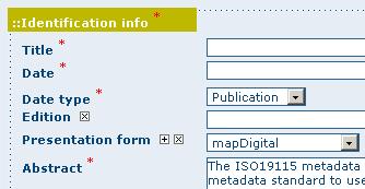
48 Metadata content: Identification Important for data search
49 Metadata content: Identification Information in abstract: data model Entity types and their attributes and the domains from which attribute values may be assigned The names and definitions of features, attributes, and attribute values
50 Metadata content: Identification
51 Metadata content: Distribution information How to access the information? Multiple transfer options are possible Contact for physical media Fees
52 Metadata content: Data quality Positional and attribute accuracy Completeness and consistency, Sources of information Methods used to produce the data Appropriate uses (scales)

53 Metadata Content: Spatial Reference
54 Metadata content: Metadata information Language, date, update status Who is responsible for the metadata?
55 Metadata content: Access and use constraints Use constraint statements can be crafted to express scale, geographic, or temporal limitations to the data Liability statements should be written by legal staff to ensure that the legal requirements for use of the data are fully outlined In general, it is far better to publish your dataset with limitations within your metadata than to later attempt to generate them in response to an inquiry or lawsuit.
56 Access and use control Use constraints and disclaimers Web clients typically include liability limitations (disclaimers) and licenses that users must accept But geoservices can be accessed directly! Therefore, use constraints must be specified in the metadata and GetCapabilities response And services must be protected from non-authorized access Within an organization: generic IP filtering and firewalls External services: need an authentication mechanism

57 Access control for geoservices There are generic mechanisms for Service-Oriented Architectures Based on XML standards like SAML and XACML However, these standards are not easily used in SDIs because Current geoservices do not use SOAP for passing information Server and client software should be modified to comply

58 Access control for geoservices Specific SDI solutions have been proposed and used Existing clients and server don t have to be modified, only intercepting components need to be added Access can be controlled for specific layers, scales, features and attributes See


59 Access control for geoservices In practice, however, most systems use simple HTTP authentication that provides a simple on/off swith for services depending on the user credentials Web browsers have a built-in implementation to ask for user and password
, based on WFS-G")
60 Current trends in SDI technology Gazetteer services (search location by name), based on WFS-G profile
61 Current trends in SDI technology Web Processing Service (WPS). Standard for discovering and calling remote processing modules Used for typical GIS analysis like spatial analysis, running distributed models Used for operations that are not easy to standardize in a specific Web service Spatial Coordinates transformation Geocoding (address finding) See, for instance: &request=getcapabilities

62 Current trends in SDI technology Tiled maps Cached and tiled Map Services (WMTS, WMS-C )
63 Current trends in SDI technology Tiled maps Static maps can be pre-calculated and tiled at different scales, like a raster pyramid Tiles can be directly server through tile services like WMTS, WMS-C, Google Earth Pre-calculated tiles can be used to quickly respond to conventional WMS requests An example is the GeoWebCache technology, used by GeoNode, which can be integrated with regular WMS servers like GeoServer

64 Current trends in SDI technology Tiled maps
65 Current trends in SDI technology Tiled maps A problem with tiled map providers like Google, Bind, OpenStreetMap, is that they only provide tiles with a specific ad-hoc coordinate system (used to be EPSG:900913, now it is officially EPSG:3857) It is difficult to overlay this data layer on other coordinate systems

66 Current trends in SDI technology Remote on-line editing with WFS-T

67 Current trends in SDI technology Remote collaborative editing (OpenStreetMap)


68 Current trends in SDI technology Remote geoprocesses (coordinate transformation, geocoding) with WPS

69 Current trends in SDI technology Real-time data integration (RSS, Common Alert Protocol)


70 Current trends in SDI technology Standard Web services for reading and controling remote sensors (SWE, SOS )


71 Current trends in SDI technology Integration with SOLAP data mining


72 Current trends in SDI technology SDI Web services in the cloud


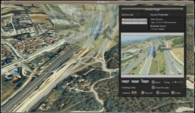
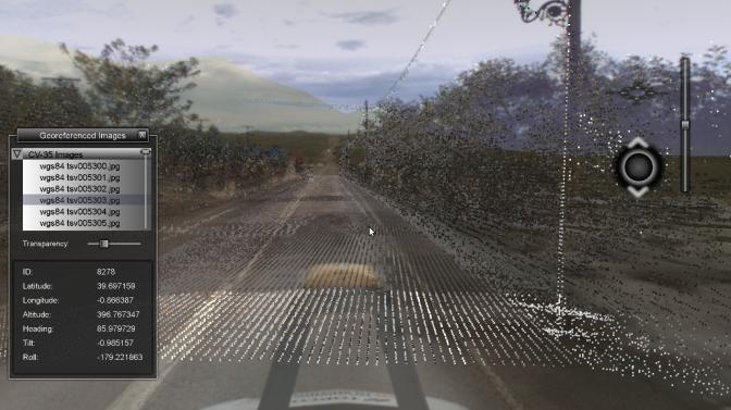

73 Current trends in SDI technology New data sources (LiDAR, georeferenced Video & street-level images)
Leveraging OGC Services in ArcGIS Server. Satish Sankaran, Esri Yingqi Tang, Esri
 Leveraging OGC Services in ArcGIS Server Satish Sankaran, Esri Yingqi Tang, Esri GIS Creating and Managing Geo Information Products - Proprietary - Open Specifications - Standards Dissemination of Geo
Web Map Servers. Mark de Blois. Septembre 2016
 Web Map Servers Mark de Blois Septembre 2016 Learning Objectives After this lecture you will be able to understand web map servers as used in Web-GIS applications Introduction A Web Map Server is a computer
GeoNode Integration with SDIs and Community Mapping
 GeoNode Integration with SDIs and Community Mapping Salvador Bayarri sbayarri@gmail.com World Bank Consultant Contents Accessing other SDI services Catalog harvesting through Geonetwork Cascading external
Leveraging OGC Services in ArcGIS Server. Satish Sankaran Yingqi Tang
 Leveraging OGC Services in ArcGIS Server Satish Sankaran ssankaran@esri.com Yingqi Tang ytang@esri.com Agenda Interoperability Enablers OGC and esri OGC Web Services ArcGIS and OGC Web Services - @ version
Providing Interoperability Using the Open GeoServices REST Specification
 2013 Esri International User Conference July 8 12, 2013 San Diego, California Technical Workshop Providing Interoperability Using the Open GeoServices REST Specification Satish Sankaran Kevin Sigwart What
Leveraging OGC Services in ArcGIS Server
 Esri International User Conference San Diego, CA Technical Workshops Jul.14 th 2011 Leveraging OGC Services in ArcGIS Server Satish Sankaran Yingqi Tang Agenda Interoperability
Interoperability and Standards Supports in ArcGIS
 Esri International User Conference San Diego, California Technical Workshops July 26, 2012 Interoperability and Standards Supports in ArcGIS Satish Sankaran, Esri Yingqi Tang, Esri Agenda Esri s participation
Leveraging OGC Standards on ArcGIS Server
 Leveraging OGC Standards on ArcGIS Server Satish Sankaran Interoperability and Standards Team James Michel III ESRI Intel Team ArcGIS Server Complete Interoperable Server-Based GIS Desktop Explorer Web
Achieving Interoperability using the ArcGIS Platform. Satish Sankaran Roberto Lucchi
 Achieving Interoperability using the ArcGIS Platform Satish Sankaran Roberto Lucchi Thank you Please fill out the session survey in your mobile app Select [Achieving Interoperability using the ArcGIS Platform]
INSPIRE: The ESRI Vision. Tina Hahn, GIS Consultant, ESRI(UK) Miguel Paredes, GIS Consultant, ESRI(UK)
 Miguel Paredes, GIS Consultant, ESRI(UK)") INSPIRE: The ESRI Vision Tina Hahn, GIS Consultant, ESRI(UK) Miguel Paredes, GIS Consultant, ESRI(UK) Overview Who are we? Introduction to ESRI Inc. and ESRI(UK) Presenters ArcGIS The ESRI Solution to
INSPIRE: The ESRI Vision Tina Hahn, GIS Consultant, ESRI(UK) Miguel Paredes, GIS Consultant, ESRI(UK) Overview Who are we? Introduction to ESRI Inc. and ESRI(UK) Presenters ArcGIS The ESRI Solution to
Esri Support for Geospatial Standards
 APRIL 2017 ArcGIS Is Open and Interoperable Esri Support for Geospatial Standards Copyright 2017 Esri All rights reserved. Printed in the United States of America. The information contained in this document
Open source technologies and INSPIRE network services in Slovak environmental agency
 Open source technologies and INSPIRE network services in Slovak environmental agency Peter Mozolík, Martin Koška, Marek Žiačik, Martin Tuchyňa Slovak Environmental Agency (SEA) SEA role within slovak SDI
Discovery and Access of Geospatial Resources Using GIS Portal Toolkit Marten Hogeweg Product Manager GIS Portal Toolkit
 Discovery and Access of Geospatial Resources Using GIS Portal Toolkit Marten Hogeweg Product Manager GIS Portal Toolkit Outline Elements of Spatial Data Infrastructures Current trends Position of GIS portals
SMARTERDECISIONS. Geospatial Portal 2013 Open Interoperable GIS/Imagery Services with ERDAS Apollo 2013 and ERDAS Imagine 2013
 Geospatial Portal 2013 Open Interoperable GIS/Imagery Services with ERDAS Apollo 2013 and ERDAS Imagine 2013 Carahsoft Intergraph Government Solutions SMARTERDECISIONS Geospatial Portal 2013 Geospatial
SDI SOLUTIONS FOR INSPIRE: TECHNOLOGIES SUPPORTING A FRAMEWORK OF COOPERATION
 SDI SOLUTIONS FOR INSPIRE: TECHNOLOGIES SUPPORTING A FRAMEWORK OF COOPERATION Roberto Lucchi 1, Marten Hogeweg 1, Guenther Pichler 2 1 Esri, Redlands, CA, USA 2 Esri Kranzberg, Germany 1 Vision INSPIRE
How to become an INSPIRE node and fully exploit the investments made?
 How to become an INSPIRE node and fully exploit the investments made? Solution patterns for consumers: end users & developers (2/2) Roberto Lucchi 22 June 2010, Krakow 1 Geoportal extension Enabling discovery
From Geoportal to Spatial Data Service Platform. Jani Kylmäaho National Land Survey of Finland Development Centre
 From Geoportal to Spatial Data Service Platform Jani Kylmäaho National Land Survey of Finland Development Centre Introduction National Land Survey of Finland - 1900 employees Development Centre - 120 employees
Introduction to ArcGIS Server 10.1
 Introduction to ArcGIS Server 10.1 E-Learning for the GIS Professional Any Time, Any Place! geospatialtraining.com Module Outline What is ArcGIS Server? GIS Resources and Services ArcGIS Server Components
DATA SHARING AND DISCOVERY WITH ARCGIS SERVER GEOPORTAL EXTENSION. Clive Reece, Ph.D. ESRI Geoportal/SDI Solutions Team
 DATA SHARING AND DISCOVERY WITH ARCGIS SERVER GEOPORTAL EXTENSION Clive Reece, Ph.D. ESRI Geoportal/SDI Solutions Team Geoportal Extension for ArcGIS Server Context within an Enterprise Spatial Data Infrastructure
Developing a Free and Open Source Software based Spatial Data Infrastructure. Jeroen Ticheler
 Developing a Free and Open Source Software based Spatial Data Infrastructure Jeroen Ticheler 1 License This work is licensed under the Creative Commons Attribution-NonCommercial-ShareAlike 2.5 License.
GeoNode Intro & Demo
 GeoNode Intro & Demo Cristiano Giovando - Global Facility for Disaster Reduction and Recovery, World Bank Paolo Corti - Center for Geographic Analysis, Harvard University Dynamic Mapping of Secondary Cities
County of Los Angeles. Chief Information Office Preferred Technologies for Geographic Information Systems (GIS) Version 2 May 2015
 Version 2 May 2015") County of Los Angeles Chief Information Office Preferred Technologies for Geographic Information Systems (GIS) Version 2 May 2015 CIO Preferred Technologies for GIS This document lists the preferred Geographic
County of Los Angeles Chief Information Office Preferred Technologies for Geographic Information Systems (GIS) Version 2 May 2015 CIO Preferred Technologies for GIS This document lists the preferred Geographic
Leveraging metadata standards in ArcGIS to support Interoperability. Aleta Vienneau and Marten Hogeweg
 Leveraging metadata standards in ArcGIS to support Interoperability Aleta Vienneau and Marten Hogeweg Leveraging metadata standards in ArcGIS to support Interoperability Overview of metadata standards
The Butterfly Effect. A proposal for distribution and management for butterfly data programs. Dave Waetjen SESYNC Butterfly Workshop May 10, 2012
 The Butterfly Effect A proposal for distribution and management for butterfly data programs Dave Waetjen SESYNC Butterfly Workshop May 10, 2012 http://butterfly.ucdavis.edu Citizen Science based Observation
Lecture note on the history and principles of geo-webservices
 A SHORT INTRODUCTION TO GEO-WEBSERVICES Lecture note on the history and principles of geo-webservices Barend Köbben Version 1.0 February 24, 2010 Contents 1 From monolithic to distributed GIS architectures
Achieving Interoperability Using Open Standards
 FedGIS Conference February 24 25, 2016 Washington, DC Achieving Interoperability Using Open Standards Satish Sankaran Marten Hogeweg Agenda Understanding Interoperability What, Why and How? ArcGIS Platform
OPEN SOURCE SOLUTIONS FOR SURVEYORS
 2 nd Sabah International Surveyors Congress 11 th 12 th March 2014 OPEN SOURCE SOLUTIONS FOR SURVEYORS Presented By : Sr Alexander Chong Director, Jurukur Antarabangsa The Benefits Of Closed Proprietary
Introduction to INSPIRE. Network Services
 Introduction to INSPIRE. Network Services European Commission Joint Research Centre Institute for Environment and Sustainability Digital Earth and Reference Data Unit www.jrc.ec.europa.eu Serving society
GEOSPATIAL ERDAS APOLLO. Your Geospatial Business System for Managing and Serving Information
 GEOSPATIAL ERDAS APOLLO Your Geospatial Business System for Managing and Serving Information ERDAS APOLLO Do you have large volumes of data, a geographicallydistributed user base and rapidly changing
Compass INSPIRE Services. Compass INSPIRE Services. White Paper Compass Informatics Limited Block 8, Blackrock Business
 Compass INSPIRE Services White Paper 2010 Compass INSPIRE Services Compass Informatics Limited Block 8, Blackrock Business Park, Carysfort Avenue, Blackrock, County Dublin, Ireland Contact Us: +353 1 2104580
Managing Image Data on the ArcGIS Platform Options and Recommended Approaches
 Managing Image Data on the ArcGIS Platform Options and Recommended Approaches Peter Becker Petroleum requirements for imagery and raster Traditional solutions and issues Overview of ArcGIS imaging capabilities
International Organization for Standardization Technical Committee 211 (ISO/TC211)
") Esri Support for Geospatial Standards: Open Geospatial Consortium (OGC) International Organization for Standardization Technical Committee 211 (ISO/TC211) An Esri White Paper April 2015 Copyright 2015
Esri Support for Geospatial Standards: Open Geospatial Consortium (OGC) International Organization for Standardization Technical Committee 211 (ISO/TC211) An Esri White Paper April 2015 Copyright 2015
Integrated Map Tool. Overview, Current Status, and Things to Come
 Integrated Map Tool Overview, Current Status, and Things to Come Integrated Mapping and Analysis Tool (IMAT) map widget Integrated Mapping Tool IMAT Reusable components for portrayal, query, analysis,
Implementing Web GIS Solutions
 Implementing Web GIS Solutions using open source software Karsten Vennemann Seattle Talk Overview Talk Overview Why and What What is Open Source (GIS)? Why use it? Application Components Overview of Web
SuperGIS Server 3.2 Value Edition Specification
 SuperGIS Server 3.2 Value Edition Specification 20140826 Specification 1. All of the services support SOAP (Simple Object Access Protocol). 2. Use map file created by SuperGIS Desktop as map services SuperGIS
Leveraging metadata standards in ArcGIS to support Interoperability. David Danko and Aleta Vienneau
 Leveraging metadata standards in ArcGIS to support Interoperability David Danko and Aleta Vienneau Leveraging Metadata Standards in ArcGIS for Interoperability Why metadata and metadata standards? Overview
Interactive Web Mapping: Overview
 Interactive Web Mapping: Overview Overview of how geospatial data is formatted requested supplied consumed by/for web technologies 2 Definitions Analysis exploring and modeling geospatial phenomena Mapping
ERDAS APOLLO Managing and Serving Geospatial Information
 ERDAS APOLLO Managing and Serving Geospatial Information ERDAS APOLLO Do you have large volumes of geospatial information, regularly updated data stores, and a distributed user base? Do you need a single,
Tutorial International Standards. Web Map Server (WMS) & Web Feature Server (WFS) Overview
 & Web Feature Server (WFS) Overview") ISO/TC 211 17 th Plenary & Associated Meetings Berlin, Germany, DIN Institute / 2003-10-31 Advisory Group on Outreach Tutorial International Standards Web Map Server (WMS) & Web Feature Server (WFS) Overview
ISO/TC 211 17 th Plenary & Associated Meetings Berlin, Germany, DIN Institute / 2003-10-31 Advisory Group on Outreach Tutorial International Standards Web Map Server (WMS) & Web Feature Server (WFS) Overview
Server Usage & Third-Party Viewers
 Server Usage & Third-Party Viewers October 2016 HiPER LOOK Version 1.4.16.0 Copyright 2015 PIXIA Corp. All Rights Reserved. Table of Contents HiPER LOOK Server Introduction... 2 Google Earth... 2 Installation...2
Adopting the Appropriate GIS Web Service Technologies
 Adopting the Appropriate GIS Web Service Technologies Bo Guo, PE, PhD GIS/IT Integration Consultant Gistic Research Inc. UT & AZ Jake Payne Database Administrator & Architect State of Utah Department of
ARCHITECTURE OF SPATIAL DATA INFRASTRUCTURE (SDI) (DRAFT)
 (DRAFT)") ARCHITECTURE OF SPATIAL DATA INFRASTRUCTURE (SDI) (DRAFT) Author: Carlo Cipolloni September 20, 2018 Version 1.0 A SDI platform to support the SEIS in the ENP South region Introduction Based on the Contribution
ARCHITECTURE OF SPATIAL DATA INFRASTRUCTURE (SDI) (DRAFT) Author: Carlo Cipolloni September 20, 2018 Version 1.0 A SDI platform to support the SEIS in the ENP South region Introduction Based on the Contribution
An Introduction to GIS for developers
 An Introduction to GIS for developers Part 4: GIS Sharing Canserina Kurnia & Tom Shippee Agenda Web GIS ArcGIS Online Cloud-based ArcGIS Server ArcGIS Server on-premises ArcGIS a complete platform discover,
PRODUCT BROCHURE ERDAS APOLLO MANAGING AND SERVING GEOSPATIAL INFORMATION
 PRODUCT BROCHURE ERDAS APOLLO MANAGING AND SERVING GEOSPATIAL INFORMATION ERDAS APOLLO Do you have large volumes of geospatial information, regularly updated data stores, and a distributed user base? Do
OpenData and INSPIRE with GeoServer, GeoNetwork and MapStore: lessons learned from real-world use cases
 OpenData and INSPIRE with GeoServer, GeoNetwork and MapStore: lessons learned from real-world use cases Ing. Simone Giannecchini, GeoSolutions Silvana Griffa, CSI Piemonte Giovanni Menduni, City of Florence
ERDAS APOLLO v2013. What s New. SMARTERDECISIONS
 ERDAS APOLLO v2013 What s New. SMARTERDECISIONS 1 ERDAS APOLLO v2013 ERDAS APOLLO Professional: includes all the functionality of ERDAS APOLLO Advantage. In addition, it provides server side geoprocessing
By Robert Slivinsky 1
 By Robert Slivinsky 1 Tell HC Mobile Application SQL Server 2008 GeoServer GeoExt- Open Layers 2 3 Desktop Splash Page 2 sec GPS/Location Approval 4 Homepage Meat - Form Categories from EOCcalls 5 Description
Esri Geoportal Server
 Esri Geoportal Server Implementing a Spatial Data Infrastructure @martenhogeweg Esri Geoportal Server Extending ArcGIS to enable discovery and use of geospatial resources in heterogeneous environments
OSGeo Web Mapping Typification: GeoMajas, Mapbender, MapFish and OpenLayers. Christoph Baudson Arnulf Christl FOSS4G 2010 Barcelona
 OSGeo Web Mapping Typification: GeoMajas, Mapbender, MapFish and OpenLayers Christoph Baudson Arnulf Christl FOSS4G 2010 Barcelona Disclaimer All information contained in this presentation has been compiled
Interoperability with ArcGIS
 Interoperability with ArcGIS Satish Sankaran Marten Hogeweg Agenda Understanding Interoperability What, Why and How? ArcGIS Platform An Open Platform Supporting Interoperability Examples from the real
The GeoPortal Cookbook Tutorial
 The GeoPortal Cookbook Tutorial Wim Hugo SAEON/ SAEOS SCOPE OF DISCUSSION Background and Additional Resources Context and Concepts The Main Components of a GeoPortal Architecture Implementation Options
Esri Support for Geospatial Standards: OGC and ISO/TC211. An Esri White Paper May 2015
 Esri Support for Geospatial Standards: OGC and ISO/TC211 An Esri White Paper May 2015 Copyright 2015 Esri All rights reserved. Printed in the United States of America. The information contained in this
ArcGIS Online. The Road Ahead Geoff Mortson
 ArcGIS Online The Road Ahead Geoff Mortson gmortson@esricanada.com ArcGIS Online Easily create and share maps Delivered as intelligent maps Access on virtually any device anyone, anywhere Compliments and
LifeWatch/EnvEurope User Forum Use Case Ecology
 LifeWatch/EnvEurope User Forum Use Case Ecology User Forum Barcelona, March 2012 Michael Mirtl (EAA, Environment Agency Austria) Wouter Los (LifeWatch) Infrastructure for Biodiversity and Ecosystem Research
An Overview of FMW MapViewer
 An Overview of FMW MapViewer Agenda What is MapViewer Select Features Getting Started Additional Resources 2 Copyright 2013, Oracle and/or its affiliates. All rights reserved. Oracle
EUCOM/AFRICOM DEFENSE USER GROUP MEETING MARCH 2010 STUTTGART WELCOME!
 EUCOM/AFRICOM DEFENSE USER GROUP MEETING 23-25 MARCH 2010 STUTTGART WELCOME! AGENDA March 23, Tuesday 0800-0900 Registration 0900-0915 Welcome and Introductions 0915-1000 Getting Started with ArcGIS Server
The French Geoportal : linking discovery and view network services. INSPIRE Conference Krakow
 The French Geoportal : linking discovery and view network services ( BRGM ) D.Richard (IGN) F. Robida Context of the French Geoportal The governance mechanism Transversal organisation based on the Ministry
InCLUDE Data Exchange. Julia Harrell, GISP GIS Coordinator, NC DENR
 InCLUDE Data Exchange Julia Harrell, GISP GIS Coordinator, NC DENR Julia.harrell@ncdenr.gov InCLUDE Project Partners NC Department of Environment & Natural Resources: The State of NC s lead environmental
ArcGIS Server: publishing geospatial data to the web using the EEA infrastructure
 ArcGIS Server: publishing geospatial data to the web using the EEA infrastructure *IMPORTANT: Map Services should be published using the EEA Map Services Tick Sheet for guidance. Contact Sebastien Petit
[ ]..,ru. GeoServer Beginner's Guide. open source^ software server. Share and edit geospatial data with this open source.
![[ ]..,ru. GeoServer Beginner's Guide. open source^ software server. Share and edit geospatial data with this open source.](/thumbs/80/80955530.jpg "[ ]..,ru. GeoServer Beginner's Guide. open source^ software server. Share and edit geospatial data with this open source.") GeoServer Beginner's Guide Share and edit geospatial data with this open source software server Stefano lacovella Brian Youngblood [ ]..,ru open source^ PUBLISHING community experience distilled BIRMINGHAMMUMBAI
GeoServer Beginner's Guide Share and edit geospatial data with this open source software server Stefano lacovella Brian Youngblood [ ]..,ru open source^ PUBLISHING community experience distilled BIRMINGHAMMUMBAI
Introduction to GeoServer
 Tutorial ID: This tutorial has been developed by BVIEER as part of the IGET web portal intended to provide easy access to geospatial education. This tutorial is released under the Creative Commons license.
Getting Started with ArcGIS for Server. Charmel Menzel and Ken Gorton
 Getting Started with ArcGIS for Server Charmel Menzel and Ken Gorton Agenda What is ArcGIS for Server? Types of Web services Publishing resources onto the Web Clients to ArcGIS for Server Editions and
Relation between Geospatial information projects related to GBIF
 Relation between Geospatial information projects related to GBIF Synthesys 3.6-Synthesys 3.7-GBIF.DE- BioGeomancer The most up to date work can always be found at: http://www.biogeografia.com/synthesys
Extend GIS. The Reach. Of Your GIS. Chris Cappelli Nathan Bennett
 Extend The Reach GIS Of Your GIS Chris Cappelli Nathan Bennett Where do your co-workers, managers, customers, and citizens go when they want to find or make a map? GIS is a practical system for problem
Who are we? Randal Hale. Nathan Saylor. GIS Coordinator for Hardin Co. Owner of North River Geographic Systems. Consultant. Owner of Saylor Mapping
 Who are we? Nathan Saylor Randal Hale GIS Coordinator for Hardin Co. Owner of North River Geographic Systems Owner of Saylor Mapping Consultant Been doing GIS since 2005 Been in the GIS Industry 20 something
Addressing Geospatial Big Data Management and Distribution Challenges ERDAS APOLLO & ECW
 Addressing Geospatial Big Data Management and Distribution Challenges ERDAS APOLLO & ECW Nouman Ahmed GeoSystems-Me (Hexagon Geospatial / ERDAS Regional Partner) Enterprise Solutions Architect Hexagon
pgrouting extends the postgis/postgresql geospatial database to provide geospatial routing and other network analysis functionality.
 Workshop: 1 pgrouting extends the postgis/postgresql geospatial database to provide geospatial routing and other network analysis functionality. Attendee s previous knowledge: SQL (PostgreSQL, PostGIS)
What s New in ArcGIS Server 10
 What s New in ArcGIS Server 10 Derek Law ArcGIS Server Product Management What s s new in ArcGIS Server 10? Agenda Highlights: Enhanced Web mapping More powerful server-based analysis Geo-collaboration
ArcGIS 9.2 Works as a Complete System
 ArcGIS 9.2 Works as a Complete System A New Way to Manage and Disseminate Geographic Knowledge Author/Serve/Use Maps Data Models Globes Metadata Use Desktop Explorer Web Map Viewer Mobile Open APIs Enterprise
Carmenta Server Product Description
 White paper Carmenta Server Product Description Carmenta AB, Tel +46-31-775 57 00, www.carmenta.com P315 121RD, 2010 Carmenta reserves the right to change the specifications at any time and without notice.
Getting Started with the ArcGIS API for JavaScript. Julie Powell, Paul Hann
 Getting Started with the ArcGIS API for JavaScript Julie Powell, Paul Hann Esri Developer Summit Berlin November 19 2012 Getting Started with the ArcGIS API for JavaScript ArcGIS for Server Is a Platform
Metadata for Data Discovery: The NERC Data Catalogue Service. Steve Donegan
 Metadata for Data Discovery: The NERC Data Catalogue Service Steve Donegan Introduction NERC, Science and Data Centres NERC Discovery Metadata The Data Catalogue Service NERC Data Services Case study:
Open Source Software: What and Why?
 ESRI and Open Source A Love Story Presented by Bates Rambow Open Source Software: What and Why? What Software that has its source code published for anyone to inspect the source code. Generally released
Understanding and Using Metadata in ArcGIS. Adam Martin Marten Hogeweg Aleta Vienneau
 Understanding and Using Metadata in ArcGIS Adam Martin Marten Hogeweg Aleta Vienneau Adam Martin National Government Account Management R&D Open Data Marten Hogeweg National Government Professional Services
TerrainOnDemand ArcGIS
 TM TerrainOnDemand ArcGIS Connect to Intermap Technologies NEXTMap data within: ArcGIS Desktop 9.3.1 and Above AGDQS0312 TerrainOnDemand ArcGIS 2 TerrainOnDemand ArcGIS Table of Contents 1. Introduction...1
INSPIRE Download Services of the CNIG (Spain) Emilio López Romero
 Emilio López Romero") INSPIRE Download Services of the CNIG (Spain) Emilio López Romero 1 The beginning One day, few years ago, we decided to implement INSPIRE seriously 2 The sources The first step was to identify the available
INSPIRE Download Services of the CNIG (Spain) Emilio López Romero 1 The beginning One day, few years ago, we decided to implement INSPIRE seriously 2 The sources The first step was to identify the available
gvsig: towards 4D GIS
 gvsig: towards 4D GIS Salvador Bayarri IVER Salvador.Bayarri@iver.es www.gvsig.gva.es Contents gvsig's background & updates 3D visualization in gvsig Time and Animation in gvsig Implementation plan Demo
The geospatial metadata catalogue. FOSS4G Barcelona. Jeroen Ticheler. Founder and chair. Director
 The geospatial metadata catalogue FOSS4G2010 - Barcelona Jeroen Ticheler Director Founder and chair GeoNetwork opensource Dutch National Geo Registry FAO GeoNetwork SwissTopo geocat.ch GeoNetwork history
Hands-on Training INSPIRE Network Services
 1 April 2014 Hands-on Training INSPIRE Network Services Jacxsens Paul SADL KU Leuven 2 Overview How will we work? Lots of demo s & exercises Quick recap on Web Mapping Service (if necessary) Introduction
Regarding the quality attributes, the architecture of the system must be:
 The SDSS System Overview This chapter gives an overview of the software architecture of the RiskChanges SDSS system. One of the objectives within the project is the development of a SDSS system for probabilistic
May 22, 2013 Ronald Reagan Building and International Trade Center Washington, DC USA
 May 22, 2013 Ronald Reagan Building and International Trade Center Washington, DC USA 1 Building Applications with Oracle MapViewer LJ Qian (lj.qian@oracle.com) Director, Software Development The following
INSPIRE Biodiversity Mashup
 INSPIRE Biodiversity Mashup Current Status 1 Kathi Schleidt Katharina.Schleidt@umweltbundesamt.at Martin Koška martin.koska@sazp.sk Peter Mozolík peter.mozolik@sazp.sk Barbara Pratschner - babsip@mac.com
Welcome to the Introduction to Mapbender
 0 Welcome to the Introduction to Mapbender Author: Astrid Emde Author: Christoph Baudson Version: 1.0 License: Creative Commons Date: 2010-08-30 1 Table of Contents 1 Project Overview 2 1.1 Geoportal Framework
Introduction to Geodatabase and Spatial Management in ArcGIS. Craig Gillgrass Esri
 Introduction to Geodatabase and Spatial Management in ArcGIS Craig Gillgrass Esri Session Path The Geodatabase - What is it? - Why use it? - What types are there? - What can I do with it? Query Layers
ArcGIS Viewer for Microsoft Silverlight An Introduction
 Esri International User Conference San Diego, CA Technical Workshops July 12, 2011 ArcGIS Viewer for Microsoft Silverlight An Introduction Art Haddad, Rich Zwaap, and Derek Law Agenda Background Product
Getting Started with the ArcGIS Server JavaScript API
 Getting Started with the ArcGIS Server JavaScript API Agenda Introduction ArcGIS Server services and mashups REST API Services Directory JavaScript API ArcGIS Server Resource Center Dojo Maps, layers,
Using ArcGIS for Server. Javier Abadía, Esri España Peter McDaid, Esri UK
 Using ArcGIS for Server Javier Abadía, Esri España Peter McDaid, Esri UK 1. Intro 2. ArcGIS for Server = Geospatial Apps Server 3. Map Services Publishing Flow Apps 4. Spatial Functionality Services Publishing
GEOMEDIA SMART CLIENT 2016
 PRODUCT DESCRIPTION GEOMEDIA SMART CLIENT 2016 PRODUCT FEATURES AND COMPARISONS GeoMedia Smart Client enables the entire organization to access and utilize rich geospatial data in their business processes.
FDO Data Access Technology at a Glance
 Autodesk Geospatial FDO Data Access Technology at a Glance Work seamlessly with your geospatial data whatever the format 1 The Challenge The growing need for openness and interoperability between traditional
GEOMEDIA SMART CLIENT 2015 PRODUCT FEATURES AND COMPARISONS
 GEOMEDIA SMART CLIENT 2015 PRODUCT FEATURES AND COMPARISONS GeoMedia Smart Client enables the entire organization to access and utilize rich geospatial data in their business processes. It delivers an
Using ESRI data in Autodesk ISD Products
 GI13-3 Using ESRI data in Autodesk ISD Products 1.5 hr. Class 02-Dec-03 3:30pm - 5:00pm Session Description: We will focus on using data in a variety of ESRI formats within the Autodesk GIS product line,
Desktop. ArcGIS Server. ArcGIS
 Getting Started with ArcGIS Server Nakul Bhatia and David Crosby ESRI Charlotte 1 Agenda g Overview of ArcGIS Server 9.3.1 Working with GIS Services Using g Web GIS Service Clients ArcGIS Online Map Caching
Serving Large-Scale Coverages - How to Tame an Elephant
 Serving Large-Scale s - How to Tame an Elephant OGC Workshop 2 INSPIRE Conference Edinburgh, 29-jun-2011 Peter Baumann Jacobs University rasdaman GmbH OGC WCS.SWG chair OGC spec editor Sensor & Image Data
Oracle Spatial Users Conference
 April 2006 April 27, 2006 Tampa Convention Center Tampa, Florida, USA April 2006 Michael Smith Physical Scientist Remote Sensing/GIS Center of Expertise Army Corps of Engineers Engineer Research & Development
Publishing image services in ArcGIS
 Esri International User Conference San Diego, California Technical Workshops July 26, 2012 Publishing image services in ArcGIS Wenxue Ju & Melanie Harlow What is an image service? A way to make image and
MapInfo Professional Evolution!
 MapInfo Professional Evolution! A long history of improvement This presentation covers what is new in all of the MapInfo Pro releases since v9.0! MapInfo Pro Release History A feature release every year
Development of Java Plug-In for Geoserver to Read GeoRaster Data. 1. Baskar Dhanapal CoreLogic Global Services Private Limited, Bangalore
 Development of Java Plug-In for Geoserver to Read GeoRaster Data 1. Baskar Dhanapal CoreLogic Global Services Private Limited, Bangalore 2. Bruce Thelen CoreLogic Spatial Solutions, Austin, USA 3. Perumal
Open Source Cloud Map User Guide
 Open Source Cloud Map User Guide Table of Contents Map Page... 1 Static Mercator Map... 1 Customizable Map... 1 Title Bar... 2 Toolbar... 2 Non Toolbar Navigation... 3 Map Window... 3 Layers / Legend Window...
A service oriented approach for geographical data sharing
 I3E 2005 Conference October 28-30, 2005" A service oriented approach for geographical data sharing Authors L. Vaccari 1, A. Ivanyuckovich 2, and M. Marchese 2 1 Autonomous Province of Trento, Trento, Italy
Introduction THE OPENGEO ARCHITECTURE
 Introduction Putting maps on the web used to be very very difficult. It required specialized software, and more important, specialized knowledge about the kinds of data and processes used to create cartographic