Projects at SDSC. Chaitan Baru Richard Marciano Data Intensive Computing Group. San Diego Supercomputer Center
|
|
|
- George Evans
- 6 years ago
- Views:
Transcription
1 Projects at SDSC Chaitan Baru Richard Marciano Data Intensive Computing Group
2 Projects at SDSC National Archives and Records Administration, NARA Persistent Archives and Electronic Records NHPRC/NARA XML and GIS axiomap I2T: An Information Integration Testbed for Digital Government
3 Projects at SDSC ( cont) AMICO In conjunction with the California Digital Library (CDL) Part of the NSF DLI-2 project ESRI Community of Science, Inc. Networked Earthquake Engineering Simulation (NEES) NSF program
 Vendors and industry Government")
4 NARA & NSF NPACI is a Highly Leveraged National Partnership of Partnerships 47 institutions, up from states, up from 18 4 countries, up from 1 5 national labs Many projects (new and old) Vendors and industry Government agencies
5 Information Based Computing Applications Data Storage Archival Storage Information Management Applications Digital Sky Neuroscience Protein Data Bank Molecular Structures Earth Systems Science Digital Library Collection Building Digital Libraries CDL UCB - Elib UCSB - ADL Stanford - SDLIP U Michigan - UMDL
6 Information Management Hierarchy Persistent Archives Storage of information model, data model, along with data Data Grid Access to data in a different administration domain Digital Library - Presentation / Information Discovery Interlib - ADEPT, UC Berkeley Digital Library Data Collection Extensible Meta-data catalog - EMCAT Data handling SDSC Storage Resource Broker - SRB Archival Storage High performance storage system - HPSS
7 Common Information Model extensible Markup Language (XML) Use tags to define semantic context for components of the data set Document Type Definition (DTD) Provides semi-structured representation for organizing tags that can be applied to groups of digital objects Development of standards for tags Digital sky, Protein Data Bank, Neuroscience brain images California Digital Library - Art Museum Image Consortium
8 Hierarchy of Information Contexts Digital object context Meta-data to define the structure of the object When publishing a digital object, must also publish the context of the object Use collections to organize objects Meta-data to define the structure of the collection When publishing a collection, must also publish the information needed to organize the collection. Use presentation context to control access Meta-data to define structure of presentation
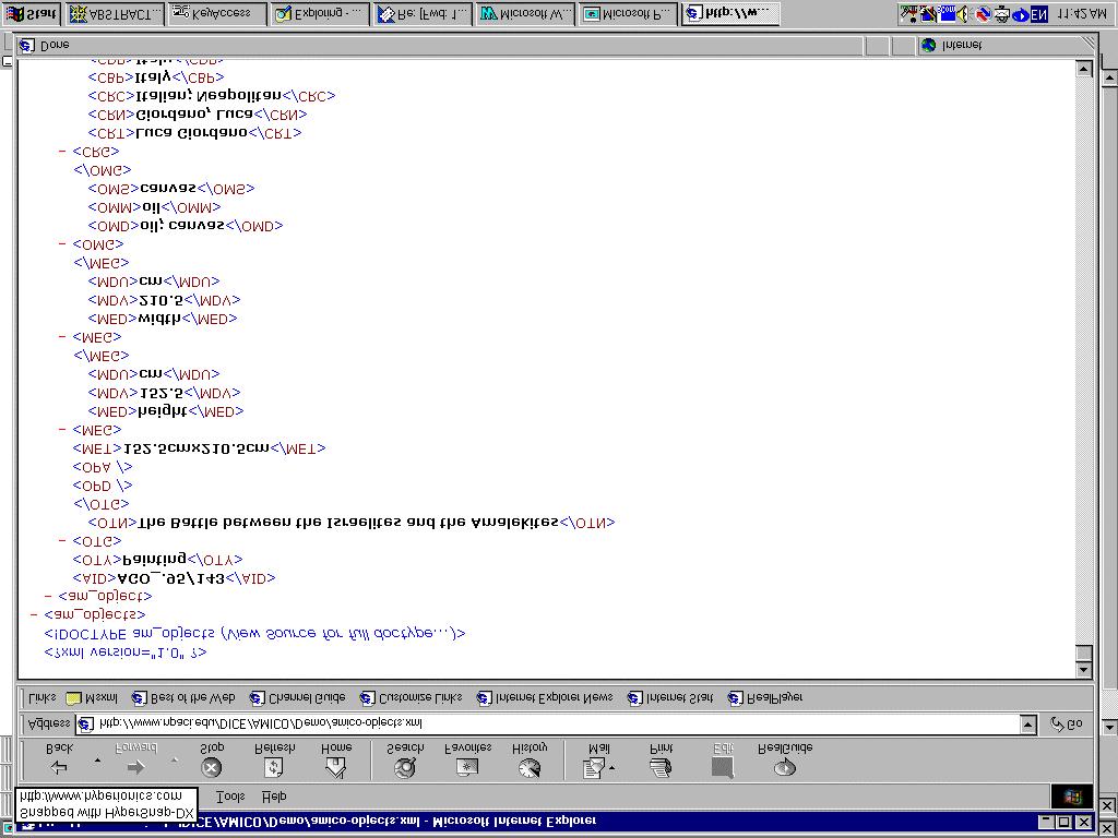
9 Persistent Object Preservation for Archives (POP-A) Electronic Records Archives: Conceptual View GSI SRB/EMCAT Tapes Accessioning Workbench Archival Repository Reference Workbench Accessi on Collection Query Disks Verify Collection Collection Rebuild Wrap & Containeri ze Metadata Present Describe Internet Records Schedules MIX Archival Research Catalog Order Fulfillment System EMCAT: Extensible Meta-data Catalog GSI: Grid Security Infrastructure MIX: Mediati on of Infor mati onusing XML SRB: Storage Resource Broker
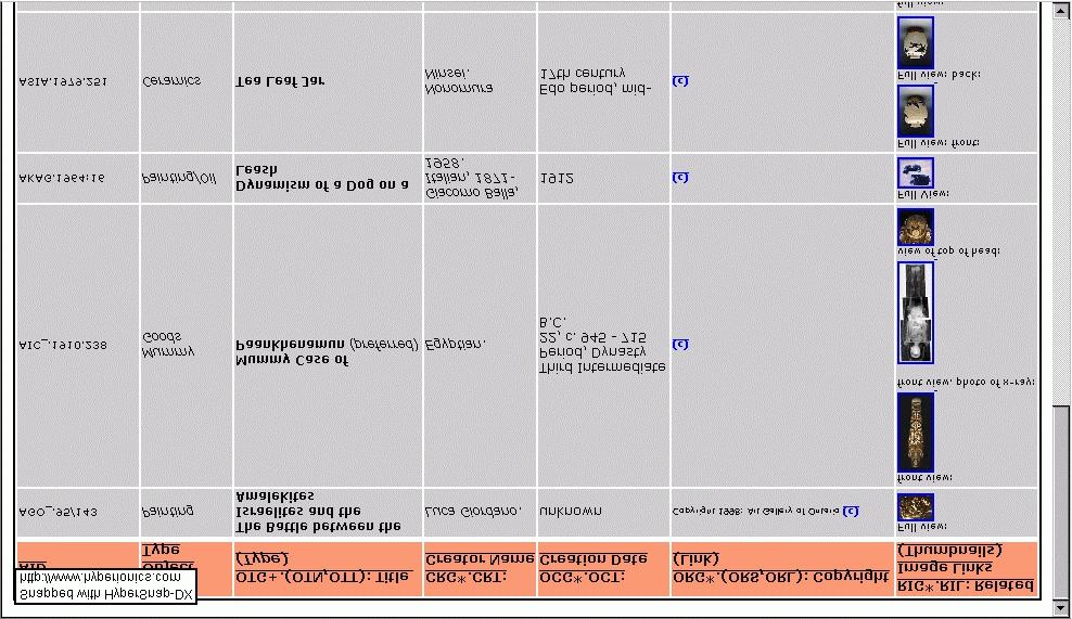
10 Collections Studied Postings Tiger/Line th Congress Bills 105th Congress Bills Electronic Archive Project Combat Area Casualties File Patent Data Image Collection (AMICO) Joint Interoperability Test SDSC Census House House NARA NARA USPTO CDL Calif. Defense

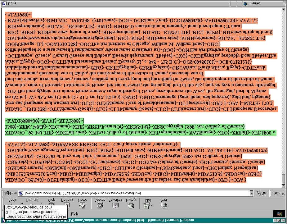
11 Postings Demo NARA_article_begin : Path: news.sdsc.edu!newshub.csu.net! newshub.sdsu.edu! newsfeed.berkeley.edu! news.cis.ohiostate.edu! news.rootsweb.com!rootsweb-gw From: Casivers@aol.com Newsgroups: soc.genealogy.hispanic Subject: Passenger Lists for Ships from Spain To Cuba Date: 22 Mar :20: Organization: RootsWeb Genealogical Data Cooperative Lines: 7 Message-ID: < f6de03@aol.com> NNTP-Posting-Host: localhost Mime-Version: 1.0 Content-Type: text/plain; charset=us-ascii Content-Transfer-Encoding: 7bit X-Trace: bl-1.rootsweb.com (23 Mar :20:37 GMT) X-Complaints-To: usenet@news.rootsweb.com NNTP-Posting-Date: 23 Mar :20:37 GMT Xref: news.sdsc.edu soc.genealogy.hispanic:3156 Does anyone know where I can get passengers lists for ships that transported Spaniards to Cuba circa 1860's? Any help would be appreciated. Thanks, Cheryl Sanchez-Sivers NARA_article_end :
12 Postings Demo 40 million records: ingested, archived, dynamically rebuilt within a month
13 NHPRC National Historical Publications & Records Commission Methodologies for the Long-Term Preservation of and Access to Software-Dependent Electronic Records funded January 1, 2000 a 3-year project
14 Introduction A project funded by the National Historical Publications and Records Commission (NHPRC): to conduct research on the long-term preservation of and access to software-dependent data objects (SD-DO), and to develop prototypes that will lead to the creation of useful tools for archivists to preserve and provide access to electronic records over the long-term.
15 Goals The organizing principles we adhere to are:!electronic records need to be input as infrastructure independent digital objects (II-DO)!Context information about relationships (collection information) needs to be maintained!the structure of a collection can be derived through an adaptive process!new electronic records can then be validated against the collection structure!error handling mechanisms can be developed!mechanisms to handle the natural evolution of a collection's structure must be developed
16 Issues Investigated II-DO creation based on the analysis of text, compound, spatial E-records II-DO creation & management automation Archivists Workbench (AW) framework: prototype of infrastructure independent management Issues: robustness structural change scalability
17 Approach Use of markup standards (SGML, XML, ) XML advantages: allows us to model SD-DO as semistructured information more flexible tolerates structural variations allows for a common information interchange format across the WWW
18 Plan of Work Research key functions of an AW: using different classes of SD-DO: textual records: ASCII, US Congress, HTML compound records: , pdf, Word, Excel spatial records: GIS data Key functionality includes: Ingestion Structural inference (DTD creation) II-DO validation Error handling DTD evolution
19 Major Tasks a. text b. compound records c. spatial I. Input I.a. I.b. I.c. II. DTD Creation II.a. II.b. II.c. III. Document Validation III.a. III.b. III.c. IV. Error Handling IV.a. IV.b. IV.c. V. DTD Evolution V.a. V.b. V.c.
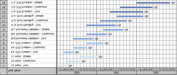
20 Three-year Timeline
21 Technology Demos: Year 1: AW for: Year 2: AW for: Year 3: AW for: Deliverables text without evolution html without evolution text with DTD evolution compound docs without DTD evolution preliminary error handling ingestion of spatial objects all types of information
22 Objectives: Advisory Board & SDSC exchange information develop a working relationship Feedback of interest: attributes for long-term preservation of SD-DO relationships to be maintained across DO & collections sources of data to drive project (evolution, ) usability of tools dissemination of results in the archival and records management community
23 axiomap Application of XML for Interactive Online Mapping
24 Spatial XML Markup Languages Metadata Standards FGDC / XML DTD ANZMETA / XML DTD Geography Markup Language (GML) 1.0 OGC Working Draft 17-Jan-2000 Web Mapping Testbed (WMT): NIMA, USACoE, FGDC, NASA, USDA, USGS... Digital Earth ( AXL (ArcXML) pre-release part of ESRI ArcIMS 31-Jan-2000
25 GML GML: XML specification to encode geo. info. For both Data Storage & Data Transport Initial release deals with OGC Simple Features: vector geodata: e.g. digital map info (streets, population, land use zones, property lines, watersheds, etc.) GML is not concerned with the visualization of geographic features (drawing of maps) Direct rendering Graphic format GML in XML Direct routing w.o. viz. Transformation into a vector graphics rendering format SVG VML VRML Numerical model
26 Web Vector Graphics: VML & SVG April 98--Adobe, IBM, Netscape, Sun: PGML (Precision Graphics Markup Language) May 98--Hewlett-Packard, Macromedia, Microsoft, Visio VML (Vector Markup Language) ==> October 98--SVG working group formed SVG contains six predefined objects: Rectangle, circle, ellipse, polyline, polygon, & line ==> Adobe: Illustrator, Photoshop, GoLive
27 Selected VML Demos
28 I2T: An Information Integration Testbed for Digital Government To be funded by the NSF Digital Government program at $720K for 3 years (unofficial) Personnel Chaitan Baru, SDSC, PI Yannis Papakonstantinou, CSE/UCSD, co-pi Amarnath Gupta, SDSC, co-pi Bob Hollebeek, U.Penn, co-pi Richard Rockwell, U.Michigan, co-pi Bertram Ludaescher, Richard Marciano, Ilya Zaslavsky, Senior Personnel
29 Government Partners U.S. Census Bureau NARA USGS Department of Community and Economic Development, State of Penna Department of Labor and Industry, State of Penna SANDAG (San Diego Association of Governments), San Diego County
30 Research Topics Extending the MIX system to support integration and mediation of geospatial information sources Modeling of GIS information in XML Spatial extensions to XML query languages Dealing with heterogeneity in accuracy resolution feature space schema XML-based representations of GIS to support long-term archiving
31 Research Topics Tools for DTD-guided wrapping of unstructured text Specifically, investigate conversion of Census codebooks to XML based on the Data Documentation Initiative (DDI) DTD Novel applications of the I2T infrastructure Census Integrated Statistical Information system (FERRETT) Sociology workbench--access to remote survey information. Ability to read DDI-encoded survey codebooks and other XML data sets Distributed decision support and data mining applications
32 The I2T Testbed Users: government, research, education, general public Research partners: SDSC UCSD CSE U.Penn, NSCP U.Michigan, ICPSR Census Integrated Info. Systems BBQ GUI Spatial Mediator Mediator Data Mining Archive Access Conflation Mediator, Data Analysis and other plug-ins Sociology Workbench Agency information sources Census USGS NARA PA State SANDAG.... Federal.... State Local Wrapped sources from multiple government levels Various surveys
33 The AMICO Digital Library Project Art Museum Image Consortium 55,146 objects (750 MB) 53,763 thumbnail images (319 MB) 57,609 full tiff images (180 GB)
34 AMICO Consortium of 26 museums AGO_ AIC_ AKAG ASIA BMFA CCP_ CMA_ DMCC FASF GEH_ JPGM LACM LOC_ MACM MBAM MCAS MIA_ MMA_ NGC_ NMAA PMA_ SFMO SJMA TFC_ WAC_ WMAA Art Gallery of Ontario Art Institute of Chicago Albright-Knox Art Gallery, Buffalo, NY Asia Society Boston Museum of Fine Arts Center for Creative Photography, U. Arizona The Cleveland Museum of Art Davis Museum and Cultural Center, Wellesley College, MA Fine Arts Museums of San Francisco George Eastman House, Rochester, NY J. Paul Getty Museum, Los Angeles, CA Los Angeles County Museum of Art Library of Congress Musée d'art contemporain de Montréal Musée des beaux-arts de Montréal Museum of Contemporary Art, San Diego The Minneapolis Institute of Arts The Metropolitan Museum of Art National Gallery of Canada, Ottawa/Ontario National Museum of American Art, Smithsonian Institution Philadelphia Museum of Art San Francisco Museum of Modern Art San Jose Museum of Art The Frick Collection, NY Walker Art Center, Minneapolis, MN Whitney Museum of American Art, NY
35 -catdata: 8 files 16,604 year1.d ,430 year1.d ,938 year1.d ,303 year1.d year1.d ,298 year1.d year1.d year1.d Raw Metadata Structure - tiffmetadata: 23 files 2963 AGO_.tiffmetadata.txt 1016 AIC_.tiffmetadata.txt 894 AKAG.tiffmetadata.txt 187 ASIA.tiffmetadata.txt 7591 BMFA.tiffmetadata.txt 401 CCP_.tiffmetadata.txt 1455 CMA_.tiffmetadata.txt 56 DCMC.tiffmetadata.txt 470 DMCC.tiffmetadata.txt FASF.tiffmetadata.txt 2137 GEH_.tiffmetadata.txt 1459 JPGM.tiffmetadata.txt 1013 LACM.tiffmetadata.txt LOC_.tiffmetadata.txt 86 MACM.tiffmetadata.txt 50 MBAM.tiffmetadata.txt 31 MCAS.tiffmetadata.txt 1440 MIA_.tiffmetadata.txt 550 MMA_.tiffmetadata.txt 1507 NGC_.tiffmetadata.txt 1416 NMAA.tiffmetadata.txt 154 PMA_.tiffmetadata.txt 158 SFMO.tiffmetadata.txt 86 SJMA.tiffmetadata.txt 68 Such.tiffmetadata.txt 396 WAC_.tiffmetadata.txt replacements.txt replacements2.txt - thumbmeta: 52,689 files AGO_ _thum.met* AGO_ _thum.met* AGO_ _thum.met*... WAC_.994C_thum.met WAC_.996C_thum.met WAC_.998C_thum.met WAC_.99C_thum.met* WMAA.1557_56_thum.met WMAA.31_426_thum.met
36 Tape Data Structure Six DLT7000 tapes. Each tape contains a tar file of TIFF images of approximately 30GB. Tape 1: AGO_, BMFA, LACM Tape 2: CMA_, LOC_, AIC_, AKAG, ASIA Tape 3: CCP_, GEH_, MACM, MCAS, MMA_, NMAA, SFMO, TFC, WMAA, DMCC, JPGM, MBAM, MIA_, NGC_, PMA_, SJMA, WAC_ Tape 4: FASF Tape 5: FASF Tape 6: FASF
37
38
39
40 AMICO Metadata Conversion Steps Tape Read Raw Metadata files: - catdata (8 files), - tiffmetada (23 files), - thumbmeta (52,689 files) Merge Consolidated Metadata files: - 1 catdata - 1 tiffmetadata - 1 thumbmeta Convert to XML 3 XML files: - 1 catdata - 1 tiffmetadata - 1 thumbmeta Split-bymuseums 1 1 XML file XML file per museum per museum Split-byfile size Multiple XML files per museum Split-bymachines Multiple museum XML files per machine excelon Dump&Load Utility excelon Data Server excelon Data Server
41 California Digital Library (CDL) Prototype The Art Museum Image Consortium (AMICO) Request for image (X.509) tif file XMAS query BBQ Interface (slide carousel interface) XML doc MIXm View based on AMICO DTD SRB/MCAT HPSS Wrapper MARC Database AMICO XML Database AMICO XML Database (XMAS: XML Matching and Structuring query language)
42 Architecture for interactive archives excelon Oracle 8i DB2 Metadata server Storage Area Network (SAN) Network attached Disk TB capacity HPSS

43 Current catalog metadata count (per museum)

44 Catalog & Image count (per museum)

45 Catalog & Image count (per museum)

46 Average tiff size in MB (per museum)
47 Community of Science, Inc. Specifying XML DTD standards for Current Research Information Systems (CRIS) Investigate tools for wrapping unstructured text mapping from source formats to CRIS DTD Enable creation of warehouse of research information and enable e-commerce
48 ESRI ESRI develop ArcInfo, ArcView, ArcIMS GIS products Project involves evaluating the ArcXML (AXL) standard Keeping AXL abreast of developments in the Geography Markup Language (GML) standard proposed by OpenGIS Consortium Identifying issues in mapping AXL to other XML standards, e.g. WAP (Wireless Application Protocol)
49 NEES Proposal to NSF s Networked Earthquake Engineering Simulation (NEES) program Develop NeesML, an XML-based standard for representing earthquake engineering simulation metadata and data NeesML will facilitate the creation of a NEES Curated Database, a warehouse of earthquake engineering simulation information
Knowledge-based Grids
 Knowledge-based Grids Reagan Moore San Diego Supercomputer Center (http://www.npaci.edu/dice/) Data Intensive Computing Environment Chaitan Baru Walter Crescenzi Amarnath Gupta Bertram Ludaescher Richard
DATA MANAGEMENT SYSTEMS FOR SCIENTIFIC APPLICATIONS
 DATA MANAGEMENT SYSTEMS FOR SCIENTIFIC APPLICATIONS Reagan W. Moore San Diego Supercomputer Center San Diego, CA, USA Abstract Scientific applications now have data management requirements that extend
Building the Archives of the Future: Self-Describing Records
 Building the Archives of the Future: Self-Describing Records Kenneth Thibodeau Director, Electronic Records Archives Program National Archives and Records Administration July 18, 2001 The Electronic Records
Cheshire 3 Framework White Paper: Implementing Support for Digital Repositories in a Data Grid Environment
 Cheshire 3 Framework White Paper: Implementing Support for Digital Repositories in a Data Grid Environment Paul Watry Univ. of Liverpool, NaCTeM pwatry@liverpool.ac.uk Ray Larson Univ. of California, Berkeley
Search Framework for a Large Digital Records Archive DLF SPRING 2007 April 23-25, 25, 2007 Dyung Le & Quyen Nguyen ERA Systems Engineering National Ar
 Search Framework for a Large Digital Records Archive DLF SPRING 2007 April 23-25, 25, 2007 Dyung Le & Quyen Nguyen ERA Systems Engineering National Archives & Records Administration Agenda ERA Overview
Digital Curation and Preservation: Defining the Research Agenda for the Next Decade
 Storage Resource Broker Digital Curation and Preservation: Defining the Research Agenda for the Next Decade Reagan W. Moore moore@sdsc.edu http://www.sdsc.edu/srb Background NARA research prototype persistent
Electronic Records Archives: Philadelphia Federal Executive Board
 Electronic Records Archives: Philadelphia Federal Executive Board L. Reynolds Cahoon Assistant Archivist for HR and IT and Chief Information Officer 18 March 2004 Agenda (The Mission) Electronic Records
Mitigating Risk of Data Loss in Preservation Environments
 Storage Resource Broker Mitigating Risk of Data Loss in Preservation Environments Reagan W. Moore San Diego Supercomputer Center Joseph JaJa University of Maryland Robert Chadduck National Archives and
Collection-Based Persistent Digital Archives - Part 1
 Página 1 de 16 D-Lib Magazine March 2000 Volume 6 Number 3 ISSN 1082-9873 Collection-Based Persistent Digital Archives - Part 1 Reagan Moore, Chaitan Baru, Arcot Rajasekar, Bertram Ludaescher, Richard
A GML-Based Open Architecture for Building A Geographical Information Search Engine Over the Internet
 A GML-Based Open Architecture for Building A Geographical Information Search Engine Over the Internet Jianting Zhang Le Gruenwald School of Computer Science The University of Oklahoma U.S.A. ggruenwald@ou.edu
Welcome. to Pre-bid meeting. Karnataka State Spatial Data Infrastructure (KSSDI) Project, KSCST, Bangalore.
 Project, KSCST, Bangalore.") Welcome to Pre-bid meeting Karnataka State Spatial Data Infrastructure (KSSDI) Project, KSCST, Bangalore. DEVELOPMENT OF KARNATAKA STATE SPATIAL DATA INFRASTRUCTURE (KSSDI) PROJECT Objective: To develop
Welcome to Pre-bid meeting Karnataka State Spatial Data Infrastructure (KSSDI) Project, KSCST, Bangalore. DEVELOPMENT OF KARNATAKA STATE SPATIAL DATA INFRASTRUCTURE (KSSDI) PROJECT Objective: To develop
NARA s Electronic Records Archives Program
 NARA s Electronic Records Archives Program Briefing for Joint Staff and Combatant Commands November 19, 2003 Ken Thibodeau Director ERA Program Management Office NARA s Electronic Records Challenge Take
A GML-Based Open Architecture for Building a Geographical Information Search Engine Over the Internet
 A GML-Based Open Architecture for Building a Geographical Information Search Engine Over the Internet Jianting Zhang Le Gruenwald The University of Oklahoma, School of Computer Science, Norman, OK, 73019
Leveraging High Performance Computing Infrastructure for Trusted Digital Preservation
 Leveraging High Performance Computing Infrastructure for Trusted Digital Preservation 12 December 2007 Digital Curation Conference Washington D.C. Richard Moore Director of Production Systems San Diego
EarthCube and Cyberinfrastructure for the Earth Sciences: Lessons and Perspective from OpenTopography
 EarthCube and Cyberinfrastructure for the Earth Sciences: Lessons and Perspective from OpenTopography Christopher Crosby, San Diego Supercomputer Center J Ramon Arrowsmith, Arizona State University Chaitan
Metadata and Encoding Standards for Digital Initiatives: An Introduction
 Metadata and Encoding Standards for Digital Initiatives: An Introduction Maureen P. Walsh, The Ohio State University Libraries KSU-SLIS Organization of Information 60002-004 October 29, 2007 Part One Non-MARC
Implementing Trusted Digital Repositories
 Implementing Trusted Digital Repositories Reagan W. Moore, Arcot Rajasekar, Richard Marciano San Diego Supercomputer Center 9500 Gilman Drive, La Jolla, CA 92093-0505 {moore, sekar, marciano}@sdsc.edu
SERVO - ACES Abstract
 1 of 6 12/27/2004 2:33 PM 2 of 6 12/27/2004 2:33 PM Implementing GIS Grid Services for the International Solid Earth Research Virtual Observatory Galip Aydin (1), Marlon Pierce (1), Geoffrey Fox (1), Mehmet
XViews: XML views of relational schemas
 SDSC TR-1999-3 XViews: XML views of relational schemas Chaitanya Baru San Diego Supercomputer Center, University of California San Diego La Jolla, CA 92093, USA baru@sdsc.edu October 7, 1999 San Diego
Feature Enhancements by Release
 Autodesk Map Feature Enhancements by Release This document highlights the feature enhancements that have occurred with each release of Autodesk Map software from Release 4 (2000i) through the current 2004
Wendy Thomas Minnesota Population Center NADDI 2014
 Wendy Thomas Minnesota Population Center NADDI 2014 Coverage Problem statement Why are there problems with interoperability with external search, storage and delivery systems Minnesota Population Center
New Mexico s RGIS Program: State Geospatial Data Clearinghouse
 New Mexico s RGIS Program: State Geospatial Data Clearinghouse Laura Gleasner Su Zhang November 10, 2016 New Mexico RGIS: The State Digital Geospatial Data Clearinghouse The Resource Geographic Information
DSpace Fedora. Eprints Greenstone. Handle System
 Enabling Inter-repository repository Access Management between irods and Fedora Bing Zhu, Uni. of California: San Diego Richard Marciano Reagan Moore University of North Carolina at Chapel Hill May 18,
OGC Simple Features (for SQL and XML/GML)
") Daniel Wirz, Department of Geography - GIS Division, University of Zurich mailto:wirz@geo.unizh.ch January 2004 What,...? Introduction Develop publicly available geoprocessing specifications. Open interfaces
Daniel Wirz, Department of Geography - GIS Division, University of Zurich mailto:wirz@geo.unizh.ch January 2004 What,...? Introduction Develop publicly available geoprocessing specifications. Open interfaces
Leveraging metadata standards in ArcGIS to support Interoperability. Aleta Vienneau and Marten Hogeweg
 Leveraging metadata standards in ArcGIS to support Interoperability Aleta Vienneau and Marten Hogeweg Leveraging metadata standards in ArcGIS to support Interoperability Overview of metadata standards
Data Exchange and Conversion Utilities and Tools (DExT)
") Data Exchange and Conversion Utilities and Tools (DExT) Louise Corti, Angad Bhat, Herve L Hours UK Data Archive CAQDAS Conference, April 2007 An exchange format for qualitative data Data exchange models
Data Exchange and Conversion Utilities and Tools (DExT) Louise Corti, Angad Bhat, Herve L Hours UK Data Archive CAQDAS Conference, April 2007 An exchange format for qualitative data Data exchange models
DataONE: Open Persistent Access to Earth Observational Data
 Open Persistent Access to al Robert J. Sandusky, UIC University of Illinois at Chicago The Net Partners Update: ONE and the Conservancy December 14, 2009 Outline NSF s Net Program ONE Introduction Motivating
Leveraging metadata standards in ArcGIS to support Interoperability. David Danko and Aleta Vienneau
 Leveraging metadata standards in ArcGIS to support Interoperability David Danko and Aleta Vienneau Leveraging Metadata Standards in ArcGIS for Interoperability Why metadata and metadata standards? Overview
SEXTANT 1. Purpose of the Application
 SEXTANT 1. Purpose of the Application Sextant has been used in the domains of Earth Observation and Environment by presenting its browsing and visualization capabilities using a number of link geospatial
Alphabet Soup: A Metadata Overview Melanie Schlosser Metadata Librarian
 Alphabet Soup: A Metadata Overview Melanie Schlosser Metadata Librarian October 10, 2007 CO-ASIS&T 1 Contents What is metadata? Types of metadata (function) Types of metadata (format) Where does metadata
The International Journal of Digital Curation Issue 1, Volume
 Towards a Theory of Digital Preservation 63 Towards a Theory of Digital Preservation Reagan Moore, San Diego Supercomputer Center June 2008 Abstract A preservation environment manages communication from
Presented by Kit Na Goh
 Developing A Geo-Spatial Search Tool Using A Relational Database Implementation of the FGDC CSDGM Model Presented by Kit Na Goh Introduction Executive Order 12906 was issued on April 13, 1994 with the
Extending the Implementation of PREMIS to Geospatial Resources in the Stanford Digital Repository: An Exploration
 Stanford Digital Repository Extending the Implementation of PREMIS to Geospatial Resources in the Stanford Digital Repository: An Exploration By Nancy J. Hoebelheinrich Metadata Coordinator Digital Library
National Association of Regional Councils: SICoP DRM 2.0 Pilot
 National Association of Regional Councils: SICoP DRM 2.0 Pilot Brand Niemann (US EPA), Chair, Semantic Interoperability Community of Practice (SICoP) Best Practices Committee (BPC), Federal CIO Council
Metadata: The Theory Behind the Practice
 Metadata: The Theory Behind the Practice Item Type Presentation Authors Coleman, Anita Sundaram Citation Metadata: The Theory Behind the Practice 2002-04, Download date 06/07/2018 12:18:20 Link to Item
Archivists Workbench: White Paper
 Archivists Workbench: White Paper Robin Chandler, Online Archive of California Bill Landis, University of California, Irvine Bradley Westbrook, University of California, San Diego 1 November 2001 Background
GUIDELINES FOR CREATION AND PRESERVATION OF DIGITAL FILES
 GUIDELINES FOR CREATION AND PRESERVATION OF DIGITAL FILES October 2018 INTRODUCTION This document provides guidelines for the creation and preservation of digital files. They pertain to both born-digital
Reducing Consumer Uncertainty
 Spatial Analytics Reducing Consumer Uncertainty Towards an Ontology for Geospatial User-centric Metadata Introduction Cooperative Research Centre for Spatial Information (CRCSI) in Australia Communicate
GML, WFS and SVG: A New Frontier of Internet GIS
 GML, WFS and SVG: A New Frontier of Internet GIS Zhong-Ren Peng Director Center for Advanced Spatial Information Research Associate Professor Department of Urban Planning University of Wisconsin-Milwaukee
BIBL NEEDS REVISION INTRODUCTION
 BIBL NEEDS REVISION FCSM Statistical Policy Seminar Session Title: Integrating Electronic Systems for Disseminating Statistics Paper Title: Interacting with Tabular Data Through the World Wide Web Paper
Enabling Interaction and Quality in a Distributed Data DRIS
 Purdue University Purdue e-pubs Libraries Research Publications 5-11-2006 Enabling Interaction and Quality in a Distributed Data DRIS D. Scott Brandt Purdue University, techman@purdue.edu James L. Mullins
Geospatial Intelligence Interoperability Through Standards Gordon C.Ferrari Chief, Content Standards and Interoperability Division
 Geospatial Intelligence Interoperability Through Standards Gordon C.Ferrari Chief, Content Standards and Interoperability Division 15 May 2002 NIMA Vision and Mission Statements National Imagery and Mapping
Storage Challenges at the San Diego Supercomputer Center
 Storage Challenges at the San Diego Supercomputer Center Richard Marciano P.O. Box 85608 San Diego, CA 92186 Ph: (619) 534-8345 Fax: (619 822-0906 E-mail: marciano@sdsc.edu Presented at the THIC meeting
CineGrid Exchange. Building A Global Networked Testbed for Distributed Media Management and Preservation
 CineGrid Exchange Building A Global Networked Testbed for Distributed Media Management and Preservation What is CineGrid? Formed 2004 non profit international membership organization Mission to build an
XML and Inter-Operability in Distributed GIS
 XML and Inter-Operability in Distributed GIS KIM Do-Hyun and KIM Min-Soo, Republic of Korea Key words: GML(Geography Markup Language), Interoperability, GIS. SUMMARY Web GIS (Geographic Information Systems)
Jeffery S. Horsburgh. Utah Water Research Laboratory Utah State University
 Advancing a Services Oriented Architecture for Sharing Hydrologic Data Jeffery S. Horsburgh Utah Water Research Laboratory Utah State University D.G. Tarboton, D.R. Maidment, I. Zaslavsky, D.P. Ames, J.L.
PA Department of Environmental Protection. Guidance for Data Management
 PA Department of Environmental Protection Guidance for Data Management September 13, 2005 Prepared for Integration with DEP Grant Guidance PA Department of Environmental Protection Information Access Strategy
Interoperability in Science Data: Stories from the Trenches
 Interoperability in Science Data: Stories from the Trenches Karen Stocks University of California San Diego Open Data for Open Science Data Interoperability Microsoft escience Workshop 2012 Interoperability
Sustainable Governance for Long-Term Stewardship of Earth Science Data
 Sustainable Governance for Long-Term Stewardship of Earth Science Data Robert R. Downs and Robert S. Chen NASA Socioeconomic Data and Applications Center (SEDAC) Center for International Earth Science
Connecting Distributed Geoservices: Interoperability research at ITC
 AGILE Interoperability Workshop, Lyon, April 23rd, 2003 Connecting Distributed Geoservices: Interoperability research at ITC Barend Köbben & Rob Lemmens {kobben,lemmens}@itc.nl International Institute
ISO PDF/A -Standard Archive file format standard for long-term preservation
 ISO PDF/A -Standard Archive file format standard for long-term preservation Marc Straat 22 March 2005 Project ArchiSafe Arbeitskreise Nationale&Internationale Standards: Rechtliche Rahmenbedingungen, Verfahren,
Data Grid Services: The Storage Resource Broker. Andrew A. Chien CSE 225, Spring 2004 May 26, Administrivia
 Data Grid Services: The Storage Resource Broker Andrew A. Chien CSE 225, Spring 2004 May 26, 2004 Administrivia This week:» 5/28 meet ½ hour early (430pm) Project Reports Due, 6/10, to Andrew s Office
NOW ON. Mike Takats Thomson Reuters April 30, 2013
 NOW ON Mike Takats Thomson Reuters April 30, 2013 Thomson Reuters, ISI and the Web of Knowledge OVER 50 YEARS OF EXPERIENCE IN CITATION INDEXING, ANALYSIS AND METRICS In 1955, Dr. Eugene Garfield revolutionized
CGM v SVG. Computer Graphics Metafile v Scalable Vector Graphic. David Manock
 It shall not be communicated to any third party without the owner s written consent. All rights reserved. CGM v SVG Computer Graphics Metafile v Scalable Vector Graphic David Manock VP Sales and Marketing
METAINFORMATION INFRASTRUCTURE FOR GEOSPATIAL INFORMATION
 2010/2 PAGES 1 7 RECEIVED 15. 6. 2009 ACCEPTED 2. 3. 2010 T. KLIMENT METAINFORMATION INFRASTRUCTURE FOR GEOSPATIAL INFORMATION ABSTRACT Tomáš KLIMENT email: tomas.kliment@stuba.sk Research field: Spatial
BSC Smart Cities Initiative
 www.bsc.es BSC Smart Cities Initiative José Mª Cela CASE Director josem.cela@bsc.es CITY DATA ACCESS 2 City Data Access 1. Standardize data access (City Semantics) Define a software layer to keep independent
INSPIRE: The ESRI Vision. Tina Hahn, GIS Consultant, ESRI(UK) Miguel Paredes, GIS Consultant, ESRI(UK)
 Miguel Paredes, GIS Consultant, ESRI(UK)") INSPIRE: The ESRI Vision Tina Hahn, GIS Consultant, ESRI(UK) Miguel Paredes, GIS Consultant, ESRI(UK) Overview Who are we? Introduction to ESRI Inc. and ESRI(UK) Presenters ArcGIS The ESRI Solution to
INSPIRE: The ESRI Vision Tina Hahn, GIS Consultant, ESRI(UK) Miguel Paredes, GIS Consultant, ESRI(UK) Overview Who are we? Introduction to ESRI Inc. and ESRI(UK) Presenters ArcGIS The ESRI Solution to
Edinburgh DataShare: Tackling research data in a DSpace institutional repository
 Edinburgh DataShare: Tackling research data in a DSpace institutional repository Robin Rice EDINA and Data Library, Information Services University of Edinburgh, Scotland DSpace User Group Meeting Gothenburg,
DLF ENVIRONMENTAL SCAN BY JEN MOHAN
 DLF ENVIRONMENTAL SCAN BY JEN MOHAN WHO? Lot 49 Group Digital Library Federation, led by Peter Brantley and Barrie Howard Mellon Foundation, specifically Don Waters from the Scholarly Communications Division
Description Cross-domain Task Force Research Design Statement
 Description Cross-domain Task Force Research Design Statement Revised 8 November 2004 This document outlines the research design to be followed by the Description Cross-domain Task Force (DTF) of InterPARES
The What, Why, Who and How of Where: Building a Portal for Geospatial Data. Alan Darnell Director, Scholars Portal
 The What, Why, Who and How of Where: Building a Portal for Geospatial Data Alan Darnell Director, Scholars Portal What? Scholars GeoPortal Beta release Fall 2011 Production release March 2012 OLITA Award
Data Interoperability in the Hydrologic Sciences
 Data Interoperability in the Hydrologic Sciences The CUAHSI Hydrologic Information System David G Tarboton 1, David Maidment 2, Ilya Zaslavsky 3, Dan Ames 4, Jon Goodall 5, Richard P Hooper 6, Jeff Horsburgh
GIS Solutions for Location-Based Services
 GIS Solutions for Location-Based Services GIS Solutions for Location-Based Services As the global community becomes increasingly more mobile, locating people, places, and things and subsequently deriving
Leveraging OGC Services in ArcGIS Server. Satish Sankaran, Esri Yingqi Tang, Esri
 Leveraging OGC Services in ArcGIS Server Satish Sankaran, Esri Yingqi Tang, Esri GIS Creating and Managing Geo Information Products - Proprietary - Open Specifications - Standards Dissemination of Geo
The NASA/GSFC Advanced Data Grid: A Prototype for Future Earth Science Ground System Architectures
 The NASA/GSFC Advanced Data Grid: A Prototype for Future Earth Science Ground System Architectures Samuel D. Gasster, Craig A. Lee, Brooks Davis, Matt Clark, Mike AuYeung, John R. Wilson Computer Systems
Using ESRI data in Autodesk ISD Products
 GI13-3 Using ESRI data in Autodesk ISD Products 1.5 hr. Class 02-Dec-03 3:30pm - 5:00pm Session Description: We will focus on using data in a variety of ESRI formats within the Autodesk GIS product line,
Esri Support for Geospatial Standards
 APRIL 2017 ArcGIS Is Open and Interoperable Esri Support for Geospatial Standards Copyright 2017 Esri All rights reserved. Printed in the United States of America. The information contained in this document
Scalable, Reliable Marshalling and Organization of Distributed Large Scale Data Onto Enterprise Storage Environments *
 Scalable, Reliable Marshalling and Organization of Distributed Large Scale Data Onto Enterprise Storage Environments * Joesph JaJa joseph@ Mike Smorul toaster@ Fritz McCall fmccall@ Yang Wang wpwy@ Institute
DIGITAL STEWARDSHIP SUPPLEMENTARY INFORMATION FORM
 OMB No. 3137 0071, Exp. Date: 09/30/2015 DIGITAL STEWARDSHIP SUPPLEMENTARY INFORMATION FORM Introduction: IMLS is committed to expanding public access to IMLS-funded research, data and other digital products:
GEO-SPATIAL METADATA SERVICES ISRO S INITIATIVE
 GEO-SPATIAL METADATA SERVICES ISRO S INITIATIVE Pushpalata B Shah, Navita J Thakkar Space Applications Centre (ISRO) Ahmedabad 380 015 - pushpa@sac.isro.gov.in Commission IV, Working Group IV/5 KEYWORDS:
IRODS: the Integrated Rule- Oriented Data-Management System
 IRODS: the Integrated Rule- Oriented Data-Management System Wayne Schroeder, Paul Tooby Data Intensive Cyber Environments Team (DICE) DICE Center, University of North Carolina at Chapel Hill; Institute
Service Oriented Architecture For GIS Applications
 The 12 th International Conference of International Association for Computer Methods and Advances in Geomechanics (IACMAG) 1-6 October, 2008 Goa, India Service Oriented Architecture For GIS Applications
Creating a Corporate Taxonomy. Internet Librarian November 2001 Betsy Farr Cogliano
 Creating a Corporate Taxonomy Internet Librarian 2001 7 November 2001 Betsy Farr Cogliano 2001 The MITRE Corporation Revised October 2001 2 Background MITRE is a not-for-profit corporation operating three
SIP AIP AIP DIP. Preservation Planning. Data Management. Ingest. Access. Archival Storage. Administration MANAGEMENT P R O D U O N S U M E R E R 4-1.
 Performance Study of Digital Object Format Identification & Validation Tools Quyen Nguyen ERA Systems Engineering National Archives & Records Administration Agenda Background Format Identification Tools
PROCESS HISTORY METADATA PEGGY GRIESINGER NATIONAL DIGITAL STEWARDSHIP RESIDENT MUSEUM OF MODERN ART DECEMBER 4 T H, 2014
 PROCESS HISTORY METADATA PEGGY GRIESINGER NATIONAL DIGITAL STEWARDSHIP RESIDENT MUSEUM OF MODERN ART DECEMBER 4 T H, 2014 Develop next generation of digital stewardship professionals 9 month residency
Integrated Map Tool. Overview, Current Status, and Things to Come
 Integrated Map Tool Overview, Current Status, and Things to Come Integrated Mapping and Analysis Tool (IMAT) map widget Integrated Mapping Tool IMAT Reusable components for portrayal, query, analysis,
Metadata Workshop 3 March 2006 Part 1
 Metadata Workshop 3 March 2006 Part 1 Metadata overview and guidelines Amelia Breytenbach Ria Groenewald What metadata is Overview Types of metadata and their importance How metadata is stored, what metadata
Syllabus DATABASE I Introduction to Database (INLS523)
") Syllabus DATABASE I Introduction to Database (INLS523) Course Description Databases are the backbones of modern scholarly, scientific, and commercial information systems. For example, NASA uses databases
Syllabus DATABASE I Introduction to Database (INLS523) Course Description Databases are the backbones of modern scholarly, scientific, and commercial information systems. For example, NASA uses databases
<goals> 10/15/11% From production to preservation to access to use: OAIS, TDR, and the FDLP
 From production to preservation to access to use:, TDR, and the FDLP Depository Library Council Meeting Federal Depository Library Conference October 2011 James A. Jacobs Data Services Librarian Emeritus
How to use Water Data to Produce Knowledge: Data Sharing with the CUAHSI Water Data Center
 How to use Water Data to Produce Knowledge: Data Sharing with the CUAHSI Water Data Center Jon Pollak The Consortium of Universities for the Advancement of Hydrologic Science, Inc. (CUAHSI) August 20,
ArcWeb Services (APIs, GIS Content and Functionality)
") ArcWeb Services SOAP API Deep Dive Marwa Mabrouk: Saravanan Rajaram: ArcWeb Development Manager ArcWeb Senior QA Engineer Developer Summit 2007 1 Topics Quick Overview Location services Spatial analysis
ArcWeb Services SOAP API Deep Dive Marwa Mabrouk: Saravanan Rajaram: ArcWeb Development Manager ArcWeb Senior QA Engineer Developer Summit 2007 1 Topics Quick Overview Location services Spatial analysis
ADVANCED GEOGRAPHIC INFORMATION SYSTEMS Vol. II - Geospatial Interoperability : The OGC Perspective Open Geospatial Consortium, Inc.
 GEOSPATIAL INTEROPERABILITY: THE OGC PERSPECTIVE Open Open Geospatial Consortium, Wayland, MA, USA Keywords: geographic information systems, geospatial services, interoperability, interface specification,
Toward the Development of a Comprehensive Data & Information Management System for THORPEX
 Toward the Development of a Comprehensive Data & Information Management System for THORPEX Mohan Ramamurthy, Unidata Steve Williams, JOSS Jose Meitin, JOSS Karyn Sawyer, JOSS UCAR Office of Programs Boulder,
Topology at the US Census
 Topology at the US Census Daniel Abugov www.acquisinc acquisinc.com dabugov@acquisinc acquisinc.com US Census Requirement for a census is incorporated into the Constitution of the United States* Used for:
Database Systems: Design, Implementation, and Management Tenth Edition. Chapter 14 Database Connectivity and Web Technologies
 Database Systems: Design, Implementation, and Management Tenth Edition Chapter 14 Database Connectivity and Web Technologies Database Connectivity Mechanisms by which application programs connect and communicate
Basics in good research data management (RDM) for reviewing DMPs
 for reviewing DMPs") Basics in good research data management (RDM) for reviewing DMPs S. Venkataraman Digital Curation Centre, Edinburgh s.venkataraman@ed.ac.uk https://doi.org/10.5281/zenodo.1461601 FOSTER & OpenAIRE webinar,
Basics in good research data management (RDM) for reviewing DMPs S. Venkataraman Digital Curation Centre, Edinburgh s.venkataraman@ed.ac.uk https://doi.org/10.5281/zenodo.1461601 FOSTER & OpenAIRE webinar,
Pennsylvania Mine Map Grant Project
 Pennsylvania Mine Map Grant Project NAAMLP 2014 Conference Patrick Jaquay, GISP PA Department of Environmental Protection Mine Map Grant Project Competitive Grant for Educational Institutions and Not-for-Profit
Web-accessible Metadata Tools. Bill Schuman GeoDecisions
 Web-accessible Metadata Tools Bill Schuman GeoDecisions Overview of Presentation Challenges with metadata systems Spatial and non-spatial data Maintenance Distribution Goals to achieve for a web metadata
Appendix 1: FGDC Press Release
 Appendix 1: FGDC Press Release The United States Geological Survey Federal Geographic Data Committee (FGDC) has awarded $32,150 to the Wyoming State Historic Preservation Office to develop a metadata standard
PROCESSING AND CATALOGUING DATA AND DOCUMENTATION: QUALITATIVE
 PROCESSING AND CATALOGUING DATA AND DOCUMENTATION: QUALITATIVE.... LIBBY BISHOP... INGEST SERVICES UNIVERSITY OF ESSEX... HOW TO SET UP A DATA SERVICE, 3 4 JULY 2013 PRE - PROCESSING Liaising with depositor:
The U.S. National Spatial Data Infrastructure
 June 18, 2014 INSPIRE Conference 2014 The U.S. National Spatial Data Infrastructure past present and future Ivan B. DeLoatch Executive Director, Federal Geographic Data Committee U.S. Geological Survey
Distributed Data Management with Storage Resource Broker in the UK
 Distributed Data Management with Storage Resource Broker in the UK Michael Doherty, Lisa Blanshard, Ananta Manandhar, Rik Tyer, Kerstin Kleese @ CCLRC, UK Abstract The Storage Resource Broker (SRB) is
Institutional Repository using DSpace. Yatrik Patel Scientist D (CS)
") Institutional Repository using DSpace Yatrik Patel Scientist D (CS) yatrik@inflibnet.ac.in What is Institutional Repository? Institutional repositories [are]... digital collections capturing and preserving
Institutional Repository using DSpace Yatrik Patel Scientist D (CS) yatrik@inflibnet.ac.in What is Institutional Repository? Institutional repositories [are]... digital collections capturing and preserving
Oct. 13, Reagan Moore
 REPORT DOCUMENTATION PAGE form Approved OMB NO. 0704-OT89 tik fim»»of remwwq imtnkilom. iwicmnq *«2' ' idurdanntllmworanymmri I of Out 1. AGENCY USE ONLY (LW Manic) 2. REPORT DATE Oct. 13, 1997 A. TITLE
GEOSPATIAL ERDAS APOLLO. Your Geospatial Business System for Managing and Serving Information
 GEOSPATIAL ERDAS APOLLO Your Geospatial Business System for Managing and Serving Information ERDAS APOLLO Do you have large volumes of data, a geographicallydistributed user base and rapidly changing
LSGI 521: Principles of GIS. Lecture 5: Spatial Data Management in GIS. Dr. Bo Wu
 Lecture 5: Spatial Data Management in GIS Dr. Bo Wu lsbowu@polyu.edu.hk Department of Land Surveying & Geo-Informatics The Hong Kong Polytechnic University Contents 1. Learning outcomes 2. From files to
Cyberinfrastructure!
 Cyberinfrastructure! David Minor! UC San Diego Libraries! San Diego Supercomputer Center! January 4, 2012! Cyberinfrastructure:! History! Definitions! Examples! History! mid-1990s:! High performance computing
Tutorial International Standards. Web Map Server (WMS) & Web Feature Server (WFS) Overview
 & Web Feature Server (WFS) Overview") ISO/TC 211 17 th Plenary & Associated Meetings Berlin, Germany, DIN Institute / 2003-10-31 Advisory Group on Outreach Tutorial International Standards Web Map Server (WMS) & Web Feature Server (WFS) Overview
ISO/TC 211 17 th Plenary & Associated Meetings Berlin, Germany, DIN Institute / 2003-10-31 Advisory Group on Outreach Tutorial International Standards Web Map Server (WMS) & Web Feature Server (WFS) Overview
XML-based production of Eurostat publications
 Doc. Eurostat/ITDG/October 2007/2.3.1 IT Directors Group 15 and 16 October 2007 BECH Building, 5, rue Alphonse Weicker, Luxembourg-Kirchberg Room QUETELET 9.30 a.m. - 5.30 p.m. 9.00 a.m 1.00 p.m. XML-based
FDO Data Access Technology at a Glance
 Autodesk Geospatial FDO Data Access Technology at a Glance Work seamlessly with your geospatial data whatever the format 1 The Challenge The growing need for openness and interoperability between traditional