Understanding and Working with the OGC Geopackage. Keith Ryden Lance Shipman
|
|
|
- Randall Powers
- 6 years ago
- Views:
Transcription


1 Understanding and Working with the OGC Geopackage Keith Ryden Lance Shipman

2 Introduction - Introduction to Simple Features - What is the GeoPackage? - Esri Support - Looking ahead
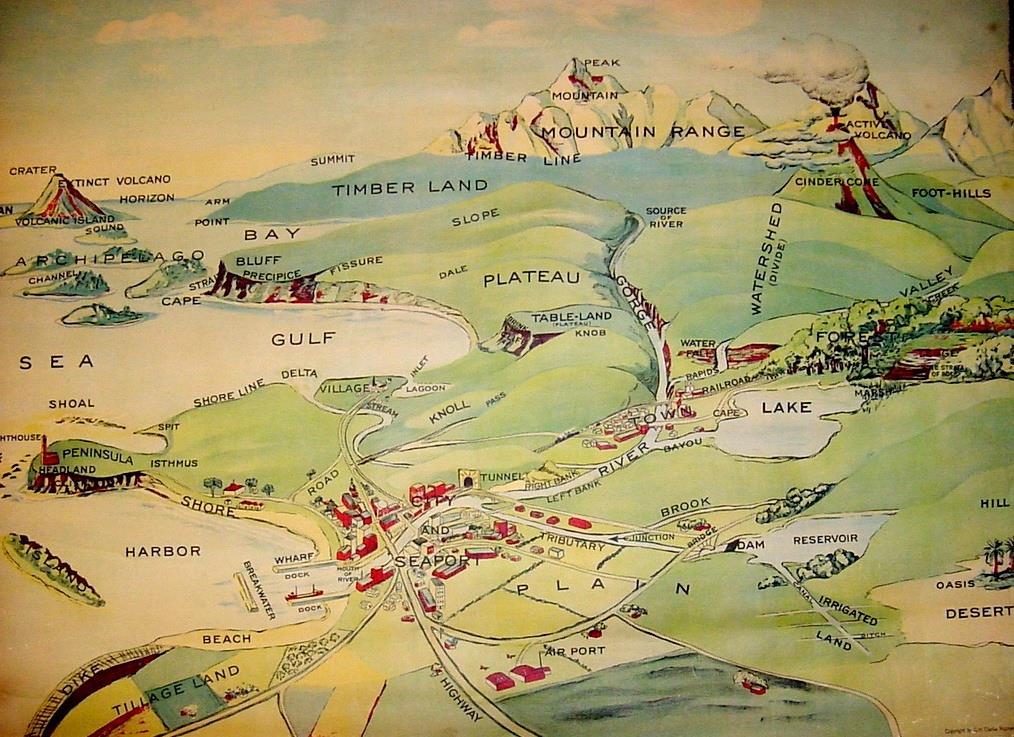
3 Geographic Things 3
4 Why add spatial data to a database? The premise: - People want to manage spatial data in association with their standard business data. - Spatial data is simply another property of a business object. The approach: - Utilize the existing SQL data access model. - Define a simple geometry object. - Define well known representations for passing structured data between systems. - Define a simple metadata schema so applications can find the spatial data. - Integrate support for spatial data types with commercial RDBMS software.
5 Simple Feature Model 10 area1 yellow Feature Table 11 area2 green 12 area3 Blue Feature 13 area4 red Geometry Feature Attribute Feature Tables contain rows (features) sharing common properties (Feature Attributes). Geometry is a Feature Attribute.
6 Database Connection Query Cursor Simple Feature access model based on SQL Value Geometry Type 1 (e.g. string) Data Access Type 2 (e.g. number) Geometry Spatial Reference Point Line Area
7 Simple Feature Geometry Geometry SpatialRefSys Point Curve Surface GeomCollection LineString Polygon MultiSurface MultiPoint MultiCurve Non-Instantiable Instantiable MultiPolygon MultiLineString
8 Some of the Major Standards Involved ISO 19125, Geographic Information - Simple feature access - Part 1: common architecture - Part 2: SQL Option ISO , Information technology Database languages SQL Multimedia and Application Packages Part 3: Spatial ISO 19107, Geographic information Spatial schema ISO 19111, Geographic information Spatial referencing by coordinates Part 1: Fundamentals ISO 19162, Geographic information Well known text for coordinate reference systems OpenGIS Simple Features Specification for SQL, Revision 1.1 OpenGIS Topic 2 Spatial Referencing by Coordinates OGC r5, Geographic information Well known text for coordinate reference systems


9 9 Spatial Database Shape files in a database Multi-user, seamless, scalable Leverage SQL - Geometry Types - Spatial indexing - Query processing - Storage Implications for data modeling - Simple feature information model with related tables - Search and scan, not traversal The master database concept - Entity-relationship modeling - Database architects (gods)
10 What is a GeoPackage?

11 What is GeoPackage? A single container for the storage and use of vector, raster, and tiled caches. Available for use on a variety of mobile platforms. Virtually any modern platform mobile, laptop, workstation, server Described by a manifest. Permissive OGC License Defined by an open standard, free of license. OGC
12 What is the GeoPackage? Introduction OGC standard for the exchange and direct use of vector geospatial features and tiled raster data. Interoperable across enterprise and personal computing environments, and is specially designed for use on Mobile devices where connectivity is limited. Implemented on top of SQLite. May contain vector data, tiled raster data or both.
13 What is the GeoPackage Specifications Max size: Approximately 140TB. - Lower size limits may be imposed by the file system and is noted in the specification. Geometries - Similar to Esri ST_Geometry - Based on OGC OpenGIS Simple Features Specification for SQL Revision 1.1 5, 1999, Clause 2.3. Point, Line and Polygon data supported.
14 What is the GeoPackage Specifications Tiled Raster Data - OGC r7 OpenGIS Web Map Tile Service Implementation Standard version (WMTS) Data Types - SHORT INTEGER, LONG INTEGER - FLOAT, DOUBLE, - TEXT, BLOB - DATETIME. See the GeoPackage standard ( for details.
15 What is the GeoPackage? Esri History In 2014 Esri announced the support of the new Open Geospatial Consortium(OGC) GeoPackage Encoding Standard. Esri actively participated in the development of this standard. One of the very early adopters of the specification supporting it even before it was approved by OGC membership as a final standard.
16 What is the GeoPackage? Versions ArcGIS Version GeoPackage Version Beta (1.0.1) (beta)
17 What is the GeoPackage? Supported Data Types Simple vector (Points, Lines, Polygons) Standalone Tables Tiled Raster
18 Esri Support
19 Esri Support Software ArcMap, ArcCatalog (10.2.2) ArcGIS Pro (1.2) Runtime ( java, Android)
20 Esri Support General Create - CreateSQLiteDatabase Geoprocessing Tool
21 Esri Support Vector Draw Import/Export - Copy/Paste, FeatureClass2FeatureClass, Table2Table Query Edit only through code. No edit session. ST_Geometry functions
22 Esri Support Raster Draw , 1.5 and before: Use Add Raster Layer , 2.0: Add like any other supported raster. Import and before: Raster2GPKG , 2.0: AddRasterToGeoPackage Geoprocessing Tool.

23 Esri Support GeoPackage Creation
 Download and install raster2gpkg tool from Git Hub (10,3,1, 10.4, 10.4.1).")
24 Esri Support Loading a Image (pre10.5) Download and install raster2gpkg tool from Git Hub (10,3,1, 10.4, ). (

25 Esri Support Loading an Image (10.5)
26 Esri Support Vector ST_Geometry The OGC standard that defines ST_Geometry includes a set of functions that allow you to create, insert, update and query the ST_Geometries via SQL. Using the SQLite3.exe command line tool you can open a ST_Geometry database, import the ST_Geometry dll and then execute the ST_Geometry functions. Select the buildings that are not completely contained within one lot.: SELECT DISTINCT (building_id) FROM bfp, lots WHERE st_intersects (lot, footprint) = 1 AND st_contains (lot, footprint) = 0;
27 Esri Support Vector ST_Geometry: Loading the extension In ArcGIS Desktop the ST_Geometry libraries can be found in Desktop10.5\DatabaseSupport\SQLite\Windows32 or from my.esri.com To load bring up SQLite3.exe. SQLite3 MyData.sqlite > SELECT load_extension( c:\program Files\ESRI\Desktop10.5\DatabaseSupport\SQLite\Windows32\stgeometry_sqlite.dll','SDE_SQL_fun cs_init );
28 Esri Support Not Supported at this time Editing Metadata
29 Looking Ahead
30 Looking Ahead Loading Tile Caches directly into GeoPackage Tiled Raster. Loading an Area Of Interest into a GeoPackage Tiled Raster. GeoPackage support was not included in Runtime Update 1. It is scheduled for Update 2, late November 2017.
31 Wrap Up
32 Wrap Up - What is the GeoPackage? - Esri Support - Looking ahead


33 Please Take Our Survey on the Esri Events App! Download the Esri Events app and find your event Select the session you attended Scroll down to find the survey Complete Answers and Select Submit


34
Working with Feature Layers. Russell Brennan Gary MacDougall
 Working with Feature Layers Russell Brennan Gary MacDougall Working with Feature Layers Session will focus on feature access and editing Highlight new features added over the last few releases Agenda Introduction
Leveraging metadata standards in ArcGIS to support Interoperability. Aleta Vienneau and Marten Hogeweg
 Leveraging metadata standards in ArcGIS to support Interoperability Aleta Vienneau and Marten Hogeweg Leveraging metadata standards in ArcGIS to support Interoperability Overview of metadata standards
Understanding and Using Metadata in ArcGIS. Adam Martin Marten Hogeweg Aleta Vienneau
 Understanding and Using Metadata in ArcGIS Adam Martin Marten Hogeweg Aleta Vienneau Adam Martin National Government Account Management R&D Open Data Marten Hogeweg National Government Professional Services
Understanding and using Metadata across the ArcGIS Platform. Aleta Vienneau Marten Hogeweg
 Understanding and using Metadata across the ArcGIS Platform Aleta Vienneau Marten Hogeweg Understanding and using Metadata across the ArcGIS Platform Metadata fundamentals ArcGIS platform Road ahead Metadata
Introduction to Geodatabase and Spatial Management in ArcGIS. Craig Gillgrass Esri
 Introduction to Geodatabase and Spatial Management in ArcGIS Craig Gillgrass Esri Session Path The Geodatabase - What is it? - Why use it? - What types are there? - What can I do with it? Query Layers
Leveraging OGC Services in ArcGIS Server. Satish Sankaran, Esri Yingqi Tang, Esri
 Leveraging OGC Services in ArcGIS Server Satish Sankaran, Esri Yingqi Tang, Esri GIS Creating and Managing Geo Information Products - Proprietary - Open Specifications - Standards Dissemination of Geo
ArcGIS Runtime SDKs Building Offline Apps. Nick Furness
 ArcGIS Runtime SDKs Building Offline Apps Nick Furness Agenda The basics - Considerations - Building blocks - Service types New! Offline maps New! Preplanned workflow What we are covering and what not
An Introduction to GIS for developers
 An Introduction to GIS for developers Part 4: GIS Sharing Canserina Kurnia & Tom Shippee Agenda Web GIS ArcGIS Online Cloud-based ArcGIS Server ArcGIS Server on-premises ArcGIS a complete platform discover,
Esri Support for Geospatial Standards
 APRIL 2017 ArcGIS Is Open and Interoperable Esri Support for Geospatial Standards Copyright 2017 Esri All rights reserved. Printed in the United States of America. The information contained in this document
Accessing and Administering your Enterprise Geodatabase through SQL and Python
 Accessing and Administering your Enterprise Geodatabase through SQL and Python Brent Pierce @brent_pierce Russell Brennan @russellbrennan hashtag: #sqlpy Assumptions Basic knowledge of SQL, Python and
OpenGIS GeoPackage Implementation Specification
 Open Geospatial Consortium Inc. Date: 2013-08-01 Reference number of this OGC project document: OGC 12-128r8 Version: 0.8.0 Category: OGC Implementation Specification Editor: Paul OpenGIS GeoPackage Implementation
Administering Your Oracle Geodatabase. Amit Kesarwani Mandar Purohit
 Administering Your Oracle Geodatabase Amit Kesarwani Mandar Purohit Intended Audience Desktop Web Device You are.. - A geodatabase administrator - An accidental DBA - A deliberate DBA Portal Portal Server
Administering Your Oracle Geodatabase. Jim McAbee Mandar Purohit
 Administering Your Oracle Geodatabase Jim McAbee Mandar Purohit Intended Audience Desktop Web Device You are.. - A geodatabase administrator - An accidental DBA - A deliberate DBA - Not sure what DBA means
Leveraging SAP HANA and ArcGIS. Melissa Jarman Eugene Yang
 Melissa Jarman Eugene Yang Outline SAP HANA database ArcGIS Support for HANA Database access Sharing via Services Geodatabase support Demo SAP HANA In-memory database Support for both row and column store
ArcGIS Data Reviewer: Ensuring Accurate and Complete Data to Meet Your Mission. John Grammer Kevin Pusey
 ArcGIS Data Reviewer: Ensuring Accurate and Complete Data to Meet Your Mission John Grammer Kevin Pusey Workshop agenda Defining data quality What is ArcGIS Data Reviewer? Automated review Semi-automated
Achieving Interoperability using the ArcGIS Platform. Satish Sankaran Roberto Lucchi
 Achieving Interoperability using the ArcGIS Platform Satish Sankaran Roberto Lucchi Thank you Please fill out the session survey in your mobile app Select [Achieving Interoperability using the ArcGIS Platform]
Design a Geodatabase. Rasu Muthurakku, Enterprise Solutions Architect / Consultant
 Rasu Muthurakku, Enterprise Solutions Architect / Consultant Agenda Overview Key Factors Design - Recommendations Key Considerations, Best Practices and Recommendations / Lessons Learned! Overview What
Data Interoperability An Introduction
 Data Interoperability An Introduction Bruce Harold Dale Lutz - Esri Inc - Safe Software What is the Data Interoperability Extension? Moving data from app to app ETL in industry jargon If you are not the
Open Geospatial Consortium
 Open Geospatial Consortium Publication Date: 2014-02-12 Approval Date: 2014-01-19 Submission Date: 2013-10-13 External identifier of this OGC document: http://www.opengis.net/doc/is/geopackage/1.0 Reference
Dynamic Situational Awareness. Through Developer Applications
 Dynamic Situational Awareness Through Developer Applications Mission Focused Applications Building Apps to support operations Agile Simple High-Performance Defense Developers GIS Simplifies Working With
ISO INTERNATIONAL STANDARD. Geographic information Simple feature access Part 1: Common architecture
 INTERNATIONAL STANDARD ISO 19125-1 First edition 2004-08-01 Corrected version 2004-11-01 Geographic information Simple feature access Part 1: Common architecture Information géographique Accès aux entités
ArcGIS Enterprise Extending Services. Bill Major
 ArcGIS Enterprise Extending Services Bill Major Agenda Introduction Geoprocessing tools Server Object Extensions Server Object Interceptors Demo APPS Desktop Web Device SHARING SERVICES Portal API DATA
Integrating Imagery into ArcGIS Runtime Application. Jie Zhang, Zhiguang Han San Jacinto, 5:30 pm 6:30 pm
 Integrating Imagery into ArcGIS Runtime Application Jie Zhang, Zhiguang Han San Jacinto, 5:30 pm 6:30 pm Overviews Imagery is an essential component of ArcGIS - Visualization, Processing and Analysis -
Sharing Web Layers and Services in the ArcGIS Platform. Melanie Summers and Ty Fitzpatrick
 Sharing Web Layers and Services in the Platform Melanie Summers and Ty Fitzpatrick Agenda Platform overview - Web GIS information model - Two deployment options Pro Sharing - User experience and workflows
AutoCAD Map 3D and ESRI ArcSDE
 AUTOCAD MAP 3D 2009 WHITE PAPER AutoCAD Map 3D and ESRI ArcSDE Many organizations, such as utilities, telecommunication providers, and government agencies, depend on geospatial data that is stored in a
ArcGIS Runtime: Building 3D Apps. Rex Hansen Adrien Meriaux
 ArcGIS Runtime: Building 3D Apps Rex Hansen Adrien Meriaux Agenda 3D across the ArcGIS Platform 3D in ArcGIS Runtime Road ahead ArcGIS 3D helps customers Create and Manage Design and Simulate Visualize
ArcGIS Online: Three-and-a-Half Ways to Create Tile Layers. Eric Anderson & Adam Eversole Esri Support Services
 ArcGIS Online: Three-and-a-Half Ways to Create Tile Layers Eric Anderson & Adam Eversole Esri Support Services Agenda 1. Introduction 2. What is a tile layer 3. How a tile layer works 4. The 3 ½ ways to
PostGIS: future developments
 PostGIS: future developments What is PostGIS GPL PostgreSQL extension for Geographic Objects Types Operators Functions Indexes Standard interfaces Extension API Current features OpenGIS Simple Features
Key Terms. Attribute join Target table Join table Spatial join
 Key Terms Attribute join Target table Join table Spatial join Lect 10A Building Geodatabase Create a new file geodatabase Map x,y data Convert shape files to geodatabase feature classes Spatial Data Formats
ArcGIS Runtime SDK for.net Building Apps. Antti Kajanus David Cardella
 ArcGIS Runtime SDK for.net Building Apps Antti Kajanus akajanus@esri.com David Cardella dcardella@esri.com Thank You to Our Generous Sponsor SDK Highlights High-performance 2D and 3D mapping Integration
hereby recognizes that Timotej Verbovsek has successfully completed the web course 3D Analysis of Surfaces and Features Using ArcGIS 10
 3D Analysis of Surfaces and Features Using ArcGIS 10 Completed on September 5, 2012 3D Visualization Techniques Using ArcGIS 10 Completed on November 19, 2011 Basics of Map Projections (for ArcGIS 10)
Troubleshooting Performance Issues with Enterprise Geodatabases. Ben Lin, Nana Dei, Jim McAbee
 Troubleshooting Performance Issues with Enterprise Geodatabases Ben Lin, Nana Dei, Jim McAbee blin@esri.com ndei@esri.com jmcabee@esri.com Workshop Agenda Performance Troubleshooting (Then & Now) Real-World
ArcGIS Enterprise: Performance and Scalability Best Practices. Darren Baird, PE, Esri
 ArcGIS Enterprise: Performance and Scalability Best Practices Darren Baird, PE, Esri dbaird@esri.com What is ArcGIS Enterprise What s Included with ArcGIS Enterprise ArcGIS Server the core web services
Building Applications with the ArcGIS Runtime SDK for WPF
 Esri International User Conference San Diego, California Technical Workshops 24 th July 2012 Building Applications with the ArcGIS Runtime SDK for WPF Euan Cameron & Paul Pilkington Agenda Introduction
Leveraging OGC Services in ArcGIS Server. Satish Sankaran Yingqi Tang
 Leveraging OGC Services in ArcGIS Server Satish Sankaran ssankaran@esri.com Yingqi Tang ytang@esri.com Agenda Interoperability Enablers OGC and esri OGC Web Services ArcGIS and OGC Web Services - @ version
Managing Imagery and Raster Data using Mosaic Datasets
 Esri European User Conference October 15-17, 2012 Oslo, Norway Hosted by Esri Official Distributor Managing Imagery and Raster Data using Mosaic Datasets Peter Becker ArcGIS is a Comprehensive Imagery
Desktop Mapping: Creating Vector Tiles. Craig Williams
 Desktop Mapping: Creating Vector Tiles Craig Williams Edie Punt @williamscraigm @epunt Overview Why vector tiles? Vector tiles in ArcGIS ArcGIS vector tile basemaps Consuming and styling vector tiles Overview
Building Java Apps with ArcGIS Runtime SDK
 Building Java Apps with ArcGIS Runtime SDK Mark Baird and Vijay Gandhi A step back in time Map making 50 years ago - http://www.nls.uk/exhibitions/bartholomew/maps-engraver - http://www.nls.uk/exhibitions/bartholomew/printing
The Oracle Enterprise Geodatabase (EGDB) Charlie Crocker Farallon Geographics, Inc.
 Charlie Crocker Farallon Geographics, Inc.") The Oracle Enterprise Geodatabase (EGDB) Charlie Crocker Farallon Geographics, Inc. www.fargeo.com Norcal URISA Chapter Meeting 2/9/2005 Todays Goals Enterprise geodatabase defined Roles Oracle can play
The Oracle Enterprise Geodatabase (EGDB) Charlie Crocker Farallon Geographics, Inc. www.fargeo.com Norcal URISA Chapter Meeting 2/9/2005 Todays Goals Enterprise geodatabase defined Roles Oracle can play
Getting Started with ArcGIS for Server. Charmel Menzel and Ken Gorton
 Getting Started with ArcGIS for Server Charmel Menzel and Ken Gorton Agenda What is ArcGIS for Server? Types of Web services Publishing resources onto the Web Clients to ArcGIS for Server Editions and
Editing Versioned Geodatabases : An Introduction
 Esri International User Conference San Diego, California Technical Workshops July 24, 2012 Editing Versioned Geodatabases : An Introduction Cheryl Cleghorn Shawn Thorne Assumptions: Basic knowledge of
ArcGIS Online: Managing Data. Jeremy Bartley Sentha Sivabalan
 ArcGIS Online: Managing Data Jeremy Bartley (jbartley@esri.com) Sentha Sivabalan (ssivabalan@esri.com) Agenda Creating and managing content like Apps, Maps, Scenes and Layers in ArcGIS Today s Topics:
FDO Data Access Technology at a Glance
 Autodesk Geospatial FDO Data Access Technology at a Glance Work seamlessly with your geospatial data whatever the format 1 The Challenge The growing need for openness and interoperability between traditional
Introduction to ArcSDE 8. John Calkins
 Introduction to ArcSDE 8 John Calkins Why are you here? Introduction to ArcSDE? What is a GeoDatabase? Existing SDE user? Existing ArcInfo user? Technical details on implementation? Just confused... ArcSDE
Encoded URLs in hyperlinks. TerraGo Publisher for ArcGIS TerraGo Publisher for ArcGIS Server TerraGo Arc2Edge Version 7.3.
 TerraGo Publisher for ArcGIS TerraGo Publisher for ArcGIS Server TerraGo Arc2Edge Version 7.3.1, December 2017 What is TerraGo Publisher for ArcGIS? What is TerraGo Arc2Edge? What s new in this release?
Bringing your Data to Life in the ArcGIS API for JavaScript: Vector Tiles. Craig Williams &
 Bringing your Data to Life in the ArcGIS API for JavaScript: Vector Tiles Craig Williams & Rene Rubalcava @williamscraigm @odoenet Overview Why vector tiles? Vector tiles in ArcGIS ArcGIS vector tile basemaps
Indexed 3D Scene (I3S) Layers Specification
 Layers Specification") Indexed 3D Scene (I3S) Layers Specification Javier Gutierrez Product Engineer Lead Esri Özgür Ertac 3D Product Engineer Esri Germany Thank You to Our Generous Sponsor Agenda ArcGIS 3D Platform Authoring
Indexed 3D Scene (I3S) Layers Specification Javier Gutierrez Product Engineer Lead Esri Özgür Ertac 3D Product Engineer Esri Germany Thank You to Our Generous Sponsor Agenda ArcGIS 3D Platform Authoring
Achieving Interoperability Using Open Standards
 FedGIS Conference February 24 25, 2016 Washington, DC Achieving Interoperability Using Open Standards Satish Sankaran Marten Hogeweg Agenda Understanding Interoperability What, Why and How? ArcGIS Platform
Understanding and Using Esri s Open i3s Specification
 Understanding and Using Esri s Open i3s Specification Keith Ryden Esri, Software Development Tamrat Belayneh Esri - Lead Software Developer 3D Services Athanasios Koukofikis HFT Stuttgart - Phd. Student
PODS Lite. Technical Overview and Guide
 PODS Lite Technical Overview and Guide Introduction Since 1998, the Pipeline Open Data Standard (PODS) Association has been focused on providing a comprehensive, open, vendor-neutral, highly scalable,
Creating and Editing a New Shapefile
 Creating and Editing a New Shapefile Written by Barbara Parmenter, revised October, 0 CREATING AND EDITING A NEW SHAPEFILE... CREATING THE GEOGRAPHIC FEATURE (POINT, LINE, OR POLYGON)... CREATING THE ATTRIBUTE
ICIT. Brian Hiller ESRI Account Manger. What s new in ArcGIS 10
 ICIT Brian Hiller ESRI Account Manger What s new in ArcGIS 10 ArcGIS 10 Fast Easy Powerful Everywhere late June 2010 ArcGIS System for Geographic Information Desktop Server Mobile Online A System A Complete
ArcGIS Desktop The Road Ahead. Amadea Azerki
 ArcGIS Desktop The Road Ahead Amadea Azerki Agenda An Overview of ArcGIS 10 Desktop Enhancements User Interface Mapping Editing Analysis Sharing Q & A ArcGIS 10 Overview Focuses on Usability and Productivity
International Organization for Standardization Technical Committee 211 (ISO/TC211)
") Esri Support for Geospatial Standards: Open Geospatial Consortium (OGC) International Organization for Standardization Technical Committee 211 (ISO/TC211) An Esri White Paper April 2015 Copyright 2015
Esri Support for Geospatial Standards: Open Geospatial Consortium (OGC) International Organization for Standardization Technical Committee 211 (ISO/TC211) An Esri White Paper April 2015 Copyright 2015
Best Practices for Designing Effective Map Services
 FedGIS Conference February 24 25, 2016 Washington, DC Best Practices for Designing Effective Map Services James Tedrick, Esri Matt Sokol, MD Dept. of Information Technology Web Mapping & Service Types
Leveraging metadata standards in ArcGIS to support Interoperability. David Danko and Aleta Vienneau
 Leveraging metadata standards in ArcGIS to support Interoperability David Danko and Aleta Vienneau Leveraging Metadata Standards in ArcGIS for Interoperability Why metadata and metadata standards? Overview
Editing & Maintaining Parcels with ArcMap. Christine Leslie Amy Andis
 Editing & Maintaining Parcels with ArcMap Christine Leslie Amy Andis What to expect An introduction to the parcel fabric A detailed explanation of the parcel fabric data model General editing techniques
Providing Interoperability Using the Open GeoServices REST Specification
 2013 Esri International User Conference July 8 12, 2013 San Diego, California Technical Workshop Providing Interoperability Using the Open GeoServices REST Specification Satish Sankaran Kevin Sigwart What
Using ESRI data in Autodesk ISD Products
 GI13-3 Using ESRI data in Autodesk ISD Products 1.5 hr. Class 02-Dec-03 3:30pm - 5:00pm Session Description: We will focus on using data in a variety of ESRI formats within the Autodesk GIS product line,
Integrating CAD Data with ArcGIS
 Integrating CAD Data with ArcGIS Agenda An Overview of CAD Drawings CAD Data Structure in ArcGIS Visualization Georeferencing Data Conversion ArcGIS for AutoCAD Q & A CAD Drawings - Overview Widely used
ArcGIS Enterprise: Architecture & Deployment. Anthony Myers
 ArcGIS Enterprise: Architecture & Deployment Anthony Myers 1 2 3 4 5 Web GIS Overview of ArcGIS Enterprise Federation & Hosted Server Deployment Patterns Implementation 1 Web GIS ArcGIS Enabling GIS for
ArcGIS Online. The Road Ahead Geoff Mortson
 ArcGIS Online The Road Ahead Geoff Mortson gmortson@esricanada.com ArcGIS Online Easily create and share maps Delivered as intelligent maps Access on virtually any device anyone, anywhere Compliments and
Interoperability with ArcGIS
 Interoperability with ArcGIS Satish Sankaran Marten Hogeweg Agenda Understanding Interoperability What, Why and How? ArcGIS Platform An Open Platform Supporting Interoperability Examples from the real
ArcGIS for Server Michele Lundeen
 ArcGIS for Server 10.1 Michele Lundeen Summary Vision Installation and Configuration Architecture Publishing Functional Enhancements Cloud Migration and Best Practices Powerful GIS capabilities Delivered
What s New in ArcGIS Server 10
 What s New in ArcGIS Server 10 Derek Law ArcGIS Server Product Management What s s new in ArcGIS Server 10? Agenda Highlights: Enhanced Web mapping More powerful server-based analysis Geo-collaboration
GEOSPATIAL ERDAS APOLLO. Your Geospatial Business System for Managing and Serving Information
 GEOSPATIAL ERDAS APOLLO Your Geospatial Business System for Managing and Serving Information ERDAS APOLLO Do you have large volumes of data, a geographicallydistributed user base and rapidly changing
Extending ArcGIS for Server. Jon Satchwell, Esri Switzerland Cédric Despierre Corporon, Esri France
 Extending ArcGIS for Server Jon Satchwell, Esri Switzerland Cédric Despierre Corporon, Esri France Agenda Introduction Server Object Extensions Server Object Interceptors THE BIG WEBGIS PICTURE Introduction
Beyond PostGIS. New developments in Open Source Spatial Databases. Karsten Vennemann. Seattle
 New developments in Open Source Spatial Databases Karsten Vennemann Seattle Talk Overview Intro Relational Databases PostGIS JASPA INGRES Geospatial MySQL Spatial Support HatBox a user space extension
Administering Your Microsoft SQL Server Geodatabase
 Esri International User Conference San Diego, California Technical Workshops July 25, 2012 Administering Your Microsoft SQL Server Geodatabase Thomas Dunn and Shannon Shields Topics for this presentation
Editing In Arcgis Desktop 10 Manual READ ONLINE
 Editing In Arcgis Desktop 10 Manual READ ONLINE Feature Service Editing using ArcGIS Desktop - Feature Service Editing using ArcGIS Desktop. In this video, ArcGIS Server product manager Ismael Chivite
Architecting ArcGIS Server Solutions for Performance and Scalability
 Architecting ArcGIS Server Solutions for Performance and Scalability Dave Wrazien Eric Miller ESRI Developer Summit 2008 1 Schedule 75 minute session 60 65 minute lecture 10 15 minutes Q & A following
ArcGIS Online: Best Practices for High-Demand Web Applications. Kelly Gerrow-Wilcox Bonnie Stayer Beth Romero
 ArcGIS Online: Best Practices for High-Demand Web Applications Kelly Gerrow-Wilcox Bonnie Stayer Beth Romero Agenda Communicating with Maps Who do you build your apps for? Layer Types Scalability and Response
SOFTWARE PRODUCT. GEOINFORMATION SYSTEM «PANORAMA» (GIS Panorama) Applied tasks. Import and export data of format ArcSDE to DB Oracle
 Applied tasks. Import and export data of format ArcSDE to DB Oracle") APPROVED -AS Orig. Inv. No. Signature and date Repl. inv. No. Copy inv. No. Signature and date SOFTWARE PRODUCT GEOINFORMATION SYSTEM «PANORAMA» (GIS Panorama) Applied tasks. Import and export data of
APPROVED -AS Orig. Inv. No. Signature and date Repl. inv. No. Copy inv. No. Signature and date SOFTWARE PRODUCT GEOINFORMATION SYSTEM «PANORAMA» (GIS Panorama) Applied tasks. Import and export data of
Building Basemaps: MapCaches and VectorTiles. Matthias Schenker Gerhard Trichtl
 Building Basemaps: MapCaches and VectorTiles Matthias Schenker Gerhard Trichtl What are Basemaps for Basemaps provide a optimal background and orientation for displaying your data on top Should be - Fast
Managing Lidar and Photogrammetric Point Clouds. Lindsay Weitz Cody Benkelman
 and Photogrammetric Point Clouds Lindsay Weitz Cody Benkelman Presentation Context What is lidar, and how does it work? Not this presentation! What can you do with lidar in ArcGIS? What does Esri recommend
Developing mapping applications with ArcGIS Runtime SDK for ios. Divesh Goyal Eric Ito
 Developing mapping applications with ArcGIS Runtime SDK for ios Divesh Goyal Eric Ito Agenda Directions & Navigation Finding places and addresses Accessing your map content What is a mapping app? Introduction
Imagery and Raster Data in ArcGIS. Abhilash and Abhijit
 Imagery and Raster Data in ArcGIS Abhilash and Abhijit Agenda Imagery in ArcGIS Mosaic datasets Raster processing ArcGIS is a Comprehensive Imagery System Integrating All Types, Sources, and Sensor Models
Esri Geodatabase (File Geodatabase API) Reader/Writer
 Reader/Writer") FME Readers and Writers 2013 SP1 Esri Geodatabase (File Geodatabase API) Reader/Writer The Esri Geodatabase (File Geodatabase API) reader and writer modules allow FME to store data in and retrieve data
FME Readers and Writers 2013 SP1 Esri Geodatabase (File Geodatabase API) Reader/Writer The Esri Geodatabase (File Geodatabase API) reader and writer modules allow FME to store data in and retrieve data
Python: Building Geoprocessing Tools
 FedGIS Conference February 13 14, 2017 Washington, DC Python: Building Geoprocessing Tools Michael Rhoades Frank Orr Why we build geoprocessing tools Your work becomes part of the geoprocessing framework
Desktop. ArcGIS Server. ArcGIS
 Getting Started with ArcGIS Server Nakul Bhatia and David Crosby ESRI Charlotte 1 Agenda g Overview of ArcGIS Server 9.3.1 Working with GIS Services Using g Web GIS Service Clients ArcGIS Online Map Caching
ArcGIS GeoEvent Server: Making 3D Scenes Come Alive with Real-Time Data
 ArcGIS GeoEvent Server: Making 3D Scenes Come Alive with Real-Time Data Morakot Pilouk, Ph.D. Senior Software Developer, Esri mpilouk@esri.com @mpesri Agenda 1 2 3 4 5 6 3D for ArcGIS Real-Time GIS Static
Python: Working with Feature Data. Ghislain Prince David Wynne
 Python: Working with Feature Data Ghislain Prince David Wynne Python: Working with Feature Data Cursors Cursors provide record-by-record, feature-by-feature access - Basic necessity for many workflows
Collector for ArcGIS: What s New. Chris LeSueur & James Tedrick
 Collector for ArcGIS: What s New Chris LeSueur & James Tedrick Outline Product overview Workflows Preparing data for Collector for ArcGIS What s new in Collector for ArcGIS v18.1.0 (Aurora) Advanced topics
ArcGIS SDK for Windows Phone and ArcGIS for SharePoint. Jo Fraley Nikki Golding
 ArcGIS SDK for Windows Phone and ArcGIS for SharePoint Jo Fraley Nikki Golding ArcGIS for SharePoint Agenda Welcome / Introductions ArcGIS for SharePoint Demo - Working with the product Road map ArcGIS
Making the Most of Raster Analysis with Living Atlas Data. Aileen Buckley, PhD, Research Cartographer Esri - Redlands
 Making the Most of Raster Analysis with Living Atlas Data Aileen Buckley, PhD, Research Cartographer Esri - Redlands Spatial Analysis with Online Data Your Desktop Web Device Never scrounge for or download
Advanced Parcel Editing. Amy Andis Tim Hodson
 Advanced Parcel Editing Amy Andis Tim Hodson Overview What to expect in this technical workshop Review of the Parcel Fabric Data Model Advanced Tips and tricks for Parcel entry Assessing Quality of Parcel
Desktop Mapping: Creating Vector Tiles. Craig Williams &
 Desktop Mapping: Creating Vector Tiles Craig Williams & Edie Punt @williamscraigm @epunt Overview Why vector tiles? Vector tiles in ArcGIS ArcGIS vector tile basemaps Consuming and styling vector tiles
SVENSK STANDARD SS-ISO :2004. Geografisk information Hantering av enklare objekt Del 1: Arkitektur (ISO :2004, IDT)
") SVENSK STANDARD Fastställd 2004-09-24 Utgåva 1 Geografisk information Hantering av enklare objekt Del 1: Arkitektur (ISO 19125-1:2004, IDT) Geographic information Simple feature access Part 1: Common architecture
SVENSK STANDARD Fastställd 2004-09-24 Utgåva 1 Geografisk information Hantering av enklare objekt Del 1: Arkitektur (ISO 19125-1:2004, IDT) Geographic information Simple feature access Part 1: Common architecture
ArcGIS Pro: What s New in Editing and Data Management
 Federal GIS Conference February 9 10, 2015 Washington, DC ArcGIS Pro: What s New in Editing and Data Management Robert LeClair ArcGIS Pro Overview Esri FedUC 2015 Technical Workshop ArcGIS Pro: What's
Creating Geoprocessing Services and Web Tools. Darren Baird, PE, Esri
 Creating Geoprocessing Services and Web Tools Darren Baird, PE, Esri Introduction Both ArcMap and ArcGIS Pro are covered Terms Geoprocessing Services and Web Tools are the same - ArcMap publishes geoprocessing
Introduction to ArcGIS Server 10.1
 Introduction to ArcGIS Server 10.1 E-Learning for the GIS Professional Any Time, Any Place! geospatialtraining.com Module Outline What is ArcGIS Server? GIS Resources and Services ArcGIS Server Components
ICAP - Intelligence Configuration for ArcGIS Pro. Natalie Feuerstein Dan Barnes Joe Bayles
 ICAP - Intelligence Configuration for ArcGIS Pro Natalie Feuerstein Dan Barnes Joe Bayles Overview Intelligence Analyst supporting Operations ArcGIS Pro SDK Intelligence Configuration for ArcGIS Pro -
Introduction to Your First ArcGIS Enterprise Deployment. Thomas Edghill & Jonathan Quinn
 Introduction to Your First ArcGIS Enterprise Deployment Thomas Edghill & Jonathan Quinn Overview Web GIS options with Esri Building a Base ArcGIS Enterprise Deployment - Overview of Base ArcGIS Enterprise
Developing Mobile Apps with the ArcGIS Runtime SDK for.net
 Developing Mobile Apps with the ArcGIS Runtime SDK for.net Rich Zwaap Morten Nielsen Esri UC 2014 Technical Workshop Agenda The ArcGIS Runtime Getting started with.net Mapping Editing Going offline Geocoding
ArcGIS Runtime SDK for Qt: Building Apps. Koushik Hajra and Lucas Danzinger
 ArcGIS Runtime SDK for Qt: Building Apps Koushik Hajra and Lucas Danzinger Cross-platform apps Agenda for today Intro to Qt Framework and ArcGIS Runtime SDK for Qt App design patterns with this SDK SDK
How To Configure & Use Insights for ArcGIS ARAVIND SIVASAILAM MATT THOMAS
 How To Configure & Use Insights for ArcGIS ARAVIND SIVASAILAM MATT THOMAS Who is this for? ArcGIS Enterprise Publishers & Administrators ArcGIS Enterprise Users (Little to No Experience with Insights)
LSGI 521: Principles of GIS. Lecture 5: Spatial Data Management in GIS. Dr. Bo Wu
 Lecture 5: Spatial Data Management in GIS Dr. Bo Wu lsbowu@polyu.edu.hk Department of Land Surveying & Geo-Informatics The Hong Kong Polytechnic University Contents 1. Learning outcomes 2. From files to
Enterprise Geographic Information Servers. Dr David Maguire Director of Products Kevin Daugherty ESRI
 Enterprise Geographic Information Servers Dr David Maguire Director of Products Kevin Daugherty ESRI Outline Introduction Enterprise GIS vs. Spatially-enabled IS Architectures for building Enterprise GIS
The What, Why, Who and How of Where: Building a Portal for Geospatial Data. Alan Darnell Director, Scholars Portal
 The What, Why, Who and How of Where: Building a Portal for Geospatial Data Alan Darnell Director, Scholars Portal What? Scholars GeoPortal Beta release Fall 2011 Production release March 2012 OLITA Award
ArcGIS Enterprise Performance and Scalability Best Practices. Andrew Sakowicz
 ArcGIS Enterprise Performance and Scalability Best Practices Andrew Sakowicz Agenda Definitions Design workload separation Provide adequate infrastructure capacity Configure Tune Test Monitor Definitions