(Geo)DCAT-AP Status, Usage, Implementation Guidelines, Extensions
|
|
|
- Magdalen Snow
- 6 years ago
- Views:
Transcription
 20.")
1 (Geo)DCAT-AP Status, Usage, Implementation Guidelines, Extensions HMA-AWG Meeting ESRIN (Room D) 20. May 2016 Uwe Voges (con terra GmbH)
 includes geo-data of most important european")
2 GeoDCAT-AP European Data Portal European Data Portal (EDP): central hub providing access to metadata about the data made accessible throughout Europe > Consortium: 450K+ metadata sets, 34 countries covered, 70+ catalogues, metadata automatically translated into 6 languages (FR, DE, EN, ES, PL, IT) includes geo-data of most important european geospatial metadata catalogues with different interfaces (INSPIRE, OGC CSW, OpenSearch) Problem: EDP is based on CKAN and Virtuoso (RDF store) > Geo-Catalogues mostly do not provide RDF (DCAT-AP) response payload > Our job: defined an architecture and made an implementation of Geo-Harvester 7
 well defined interface Interface (OpenData-GEO - ODG) is subset of OAI-PMH spec and returns GeoDCAT-AP Every ODG-Adapter Type can harvest one Geo-interface type able to process the harvesting in")
3 GeoDCAT-AP European Data Portal EDP Harvester interact with just one(!) well defined interface Interface (OpenData-GEO - ODG) is subset of OAI-PMH spec and returns GeoDCAT-AP Every ODG-Adapter Type can harvest one Geo-interface type able to process the harvesting in blocks (partitioning) and supports differential harvesting based on the metadata s datestamp (last modified date). ODG Interface is based on REST: accepts simple query- (or better harvesting-) requests with just a few parameters (e.g. startdatetime, enddatetime, startpos/maxrecs (resumption, for partitioning). ODG Adapter map ISO metadata to GeoDCAT-AP > classifications, schema and semantic tests and data quality improvements > linking to related information (e.g. INSPIRE Annex Theme to SKOS-based GEMET thesaurus, linking to Eurovoc, ) 8
: RDF vocabulary for interoperability between data catalogs published on the Web DCAT Application Profile for data portals in Europe (DCAT-AP, https://joinup.ec.europa.")
4 DCAT / DCAT-AP V 1.1 DCAT ( RDF vocabulary for interoperability between data catalogs published on the Web DCAT Application Profile for data portals in Europe (DCAT-AP, dcat_application_profile/asset_release/ dcat-ap-v11): > describing public sector datasets in EU > Basic use case is to enable cross-data portal search for data sets > Provides semantic interoperability with other applications on the basis of reuse of established controlled vocabularies (e.g. EuroVoc, Dublin Core, SDMX, etc). 9
5 GeoDCAT-AP V 1.0 GeoDCAT-AP: extension of DCAT-AP for describing geospatial datasets / series / services > > Spec was elaborated by a WG under the EU ISA programme > provides RDF syntax binding for ISO core and INSPIRE metadata elements > does not replace the INSPIRE Metadata Regulation nor the INSPIRE Metadata technical guidelines based on ISO and ISO > Provides INSPIRE metadata to be used in other contexts / for other use cases GeoDCAT-AP defines a Core and an Extended Version. > Core: alignments for the subset of INSPIRE metadata elements that can be mapped to DCAT-AP > enables harvesting and re-use of INSPIRE metadata records through DCAT-AP-conformant applications and services. > For a number of INSPIRE metadata elements, GeoDCAT-AP proposes the use of URI code list registers. 10

6 GeoDCAT-AP GeoDCAT-AP based definitions > Extended: alignments for those INSPIRE metadata elements not included in GeoDCAT-AP Core > In EDP we use Core with XML encoding > JSON-LD would also be possible > Tools: > XSLT script existing that transforms ISO metadata into Geo/DCAT-AP > For the EDP we developed our own which is better aligned with EDP requirements 11
7 GeoDCAT-AP. 12
 DCAT-AP How to")
8 DCAT-AP V 1.0 Implementation Guidelines (Extensions) How to model dataset series: e.g. dct:haspart, dct:ispartof URIs for Organizations: investigate the existence of sources Modelling of publisher vs. contact point Mapping national themes to MDR Data Theme Vocabulary How to describe and refer to licences Which identifiers to use for datasets and distributions How to extend (profile) DCAT-AP How to detect and handle duplicates (e.g. when metadata is harvested from different portals) Controlled keywords DCAT-AP currently defined as an RDF vocabulary with additional recommendations concerning cardinalities, datatypes and value vocabularies that go beyond the base DCAT recommendation. > Suggestion: to publish an OWL expression of DCAT-AP. How to model and express provenance? Source and lineage of metadata and data, use of PROV-O Standard Entity-ID Naming Service Mapping DCAT-AP to CKAN How to structure and partition DCAT-AP files Which tools exist for creating DCAT-AP. DCAT-AP API. Validation Relationships between an dataset and its source Data versioning 13
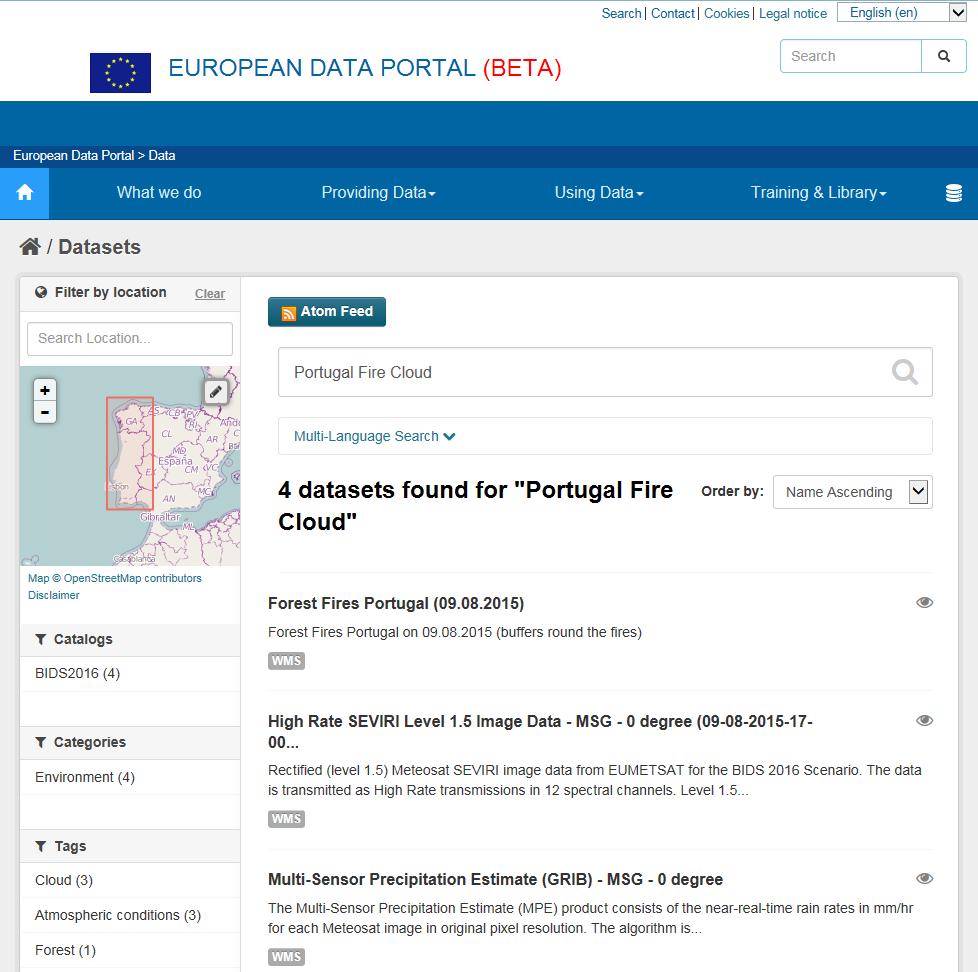
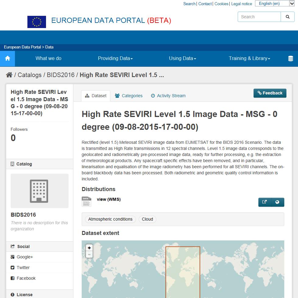
9 DCAT-AP V 1.0 Service Access Extension Service based data access: I m working on this Datasets often not provided as fix downloadable items (as DCAT presumes) Instead: provided via standardized access services allowing dynamic access Reasons: e.g. huge datasets requiring data storage and complex processing (Geo)DCAT-AP does not have appropriate means to model this As service based access is a distribution channel -> dcat:distribution appropriate class to model service access Simple accessurl not sufficient, to cover service based use cases. Instead: > URL-template including parameters (described by name, type, constraints, ) > URL may point to service or to a service-description(!) > Different protocol bindings: HTTP/GET/KVP, HTTP/POST/XML, SOAP, > Format + Compression(!) > ServiceType: e.g. download, view, Service Standard: e.g. OGC WMS EUMETSAT High Rate SEVIRI Level 1.5 Meteosat Second Generation (MSG) - served as OGC Web Map Service (Esri ArcGIS) Client: European Data Portal - OGC WMS Client (based on con terra map.apps) Request (sample): BIDS2016/BIDS2016_SEVIRI_ _17_00_00/ ImageServer/WMSServer? service=wms&version=1.3.0&request=getmap&crs=crs: 84&bbox=-30.21,21.92,-10.05, &width=1200&height=7 10&layers=0&styles=default&format=image/png32

10 DCAT-AP V 1.0 Service Access Extension First approach: link to OSDD, Capabilities, WSDL,. Problem: with service description in external file, the provider has to create and process this file on a web-accessible endpoint. Better: include description into DCAT-AP. But then we need to develop (or use -if somewhere already existing) such an RDF-based representation. 15

11 DCAT-AP V 1.0 Service Access Extension 16
The European Commission s science and knowledge service. Joint Research Centre
 The European Commission s science and knowledge service Joint Research Centre GeoDCAT-AP The story so far Andrea Perego, Antonio Rotundo, Lieven Raes GeoDCAT-AP Webinar 6 June 2018 What is GeoDCAT-AP Geospatial
GeoDCAT-AP Representing geographic metadata by using the "DCAT application profile for data portals in Europe"
 GeoDCAT-AP Representing geographic metadata by using the "DCAT application profile for data portals in Europe" Andrea Perego, Vlado Cetl, Anders Friis-Christensen, Michael Lutz, Lorena Hernandez Joint
/// INTEROPERABILITY BETWEEN METADATA STANDARDS: A REFERENCE IMPLEMENTATION FOR METADATA CATALOGUES
 /// Position Paper /// INTEROPERABILITY BETWEEN METADATA STANDARDS: A REFERENCE IMPLEMENTATION FOR METADATA CATALOGUES /// Keywords: Public administration, Metadata, Geographical Information, Geospatial
Harvesting Open Government Data with DCAT-AP
 Fraunhofer FOKUS Institute for Open Communication Systems AlanDavidRobb / Pixabay (CC0) Harvesting Open Government Data with DCAT-AP Fabian Kirstein, 21. March 2018 The European Data Portal offers more
Linking and Finding Earth Observation (EO) Data on the Web
 Data on the Web") Linking and Finding Earth Observation (EO) Data on the Web MACS-G20 Workshop: Linked Open Data in Agriculture Berlin, September 27-28, 2017 Dr. Uwe Voges u.voges@conterra.de Introduction Earth Observation
Linking and Finding Earth Observation (EO) Data on the Web MACS-G20 Workshop: Linked Open Data in Agriculture Berlin, September 27-28, 2017 Dr. Uwe Voges u.voges@conterra.de Introduction Earth Observation
DCAT-AP FOR DATA PORTALS IN EUROPE
 DCAT-AP FOR DATA PORTALS IN EUROPE BRECHT WYNS PWC EU SERVICES 30 November 2016 SDSVoc, Amsterdam Prepared for the ISA 2 programme by PwC EU Services AUTHORS: BRECHT WYNS, MAKX DEKKERS, NIKOLAOS LOUTAS,
Reducing Consumer Uncertainty
 Spatial Analytics Reducing Consumer Uncertainty Towards an Ontology for Geospatial User-centric Metadata Introduction Cooperative Research Centre for Spatial Information (CRCSI) in Australia Communicate
Leveraging metadata standards in ArcGIS to support Interoperability. Aleta Vienneau and Marten Hogeweg
 Leveraging metadata standards in ArcGIS to support Interoperability Aleta Vienneau and Marten Hogeweg Leveraging metadata standards in ArcGIS to support Interoperability Overview of metadata standards
GeoDCAT-AP: Use cases and open issues
 Authors Affiliation Andrea Perego, Anders Friis-Christensen, Michael Lutz European Commission, Joint Research Centre (JRC) (https://ec.europa.eu/jrc/) This paper illustrates some issues and use cases identified
Semantic challenges in sharing dataset metadata and creating federated dataset catalogs
 Linked Open Data in Agriculture MACS-G20 Workshop in Berlin, September 27th 28th, 2017 Semantic challenges in sharing dataset metadata and creating federated dataset catalogs The example of the CIARD RING
INSPIRE & Environment Data in the EU
 INSPIRE & Environment Data in the EU Andrea Perego Research Data infrastructures for Environmental related Societal Challenges Workshop @ pre-rda P6 Workshops, Paris 22 September 2015 INSPIRE in a nutshell
Evolution of INSPIRE interoperability solutions for e-government
 Evolution of INSPIRE interoperability solutions for e-government INSPIRE Implementation State-of-Play 26/05/2015 Robin S. Smith www.jrc.ec.europa.eu Serving society Stimulating innovation Supporting legislation
GeoDCAT-AP. Working Group Meeting 1. Tuesday 31 March 2015, 14:00-16:00 CET (UTC+2)
") GeoDCAT-AP Working Group Meeting 1 Tuesday 31 March 2015, 14:00-16:00 CET (UTC+2) How to enter the Virtual Meeting Room? See https://joinup.ec.europa.eu/node/139765 1. Web connection: http://ec-wacs.adobeconnect.com/geodcat-ap/
GeoDCAT-AP Working Group Meeting 1 Tuesday 31 March 2015, 14:00-16:00 CET (UTC+2) How to enter the Virtual Meeting Room? See https://joinup.ec.europa.eu/node/139765 1. Web connection: http://ec-wacs.adobeconnect.com/geodcat-ap/
Reducing Consumer Uncertainty Towards a Vocabulary for User-centric Geospatial Metadata
 Meeting Host Supporting Partner Meeting Sponsors Reducing Consumer Uncertainty Towards a Vocabulary for User-centric Geospatial Metadata 105th OGC Technical Committee Palmerston North, New Zealand Dr.
Leveraging metadata standards in ArcGIS to support Interoperability. David Danko and Aleta Vienneau
 Leveraging metadata standards in ArcGIS to support Interoperability David Danko and Aleta Vienneau Leveraging Metadata Standards in ArcGIS for Interoperability Why metadata and metadata standards? Overview
Spatial Data on the Web
 Spatial Data on the Web Tools and guidance for data providers The European Commission s science and knowledge service W3C Data on the Web Best Practices 35 W3C/OGC Spatial Data on the Web Best Practices
INSPIRE & Linked Data: Bridging the Gap Part II: Tools for linked INSPIRE data
 Making the Web an Exploratory Place for Geospatial Knowledge INSPIRE & Linked Data: Bridging the Gap Part II: Tools for linked INSPIRE data Michalis Alexakis Spiros Athanasiou Nikos Georgomanolis Giorgos
ISA Action 1.17: A Reusable INSPIRE Reference Platform (ARE3NA)
") ISA Action 1.17: A Reusable INSPIRE Reference Platform (ARE3NA) Expert contract supporting the Study on RDF and PIDs for INSPIRE Deliverable D.EC.3.2 RDF in INSPIRE Open issues, tools, and implications
ISA Action 1.17: A Reusable INSPIRE Reference Platform (ARE3NA) Expert contract supporting the Study on RDF and PIDs for INSPIRE Deliverable D.EC.3.2 RDF in INSPIRE Open issues, tools, and implications
Data is the new Oil (Ann Winblad)
") Data is the new Oil (Ann Winblad) Keith G Jeffery keith.jeffery@keithgjefferyconsultants.co.uk 20140415-16 JRC Workshop Big Open Data Keith G Jeffery 1 Data is the New Oil Like oil has been, data is Abundant
Data is the new Oil (Ann Winblad) Keith G Jeffery keith.jeffery@keithgjefferyconsultants.co.uk 20140415-16 JRC Workshop Big Open Data Keith G Jeffery 1 Data is the New Oil Like oil has been, data is Abundant
Using DCAT-AP for research data
 Authors Affiliation Andrea Perego, Anders Friis-Christensen, Lorenzino Vaccari, Chrisa Tsinaraki European Commission, Joint Research Centre (JRC) (https://ec.europa.eu/jrc/) This paper outlines a set of
Metadata of geographic information
 Metadata of geographic information Kai Koistinen Management of environmental data and information 4.10.2017 Topics Metadata of geographic information What is metadata? Metadata standards and recommendations
Portal Version User Manual
 Portal Version 2.0 - User Manual V1.0 April 2017 Portal Version 2.0 User Manual V1.0 April 2017 Table of Contents 1 Introduction... 4 1.1 Purpose of the Document... 4 1.2 Reference Documents... 4 1.3 Terminology...
For each use case, the business need, usage scenario and derived requirements are stated. 1.1 USE CASE 1: EXPLORE AND SEARCH FOR SEMANTIC ASSESTS
 1 1. USE CASES For each use case, the business need, usage scenario and derived requirements are stated. 1.1 USE CASE 1: EXPLORE AND SEARCH FOR SEMANTIC ASSESTS Business need: Users need to be able to
1. CONCEPTUAL MODEL 1.1 DOMAIN MODEL 1.2 UML DIAGRAM
 1 1. CONCEPTUAL MODEL 1.1 DOMAIN MODEL In the context of federation of repositories of Semantic Interoperability s, a number of entities are relevant. The primary entities to be described by ADMS are the
INSPIRE: The ESRI Vision. Tina Hahn, GIS Consultant, ESRI(UK) Miguel Paredes, GIS Consultant, ESRI(UK)
 Miguel Paredes, GIS Consultant, ESRI(UK)") INSPIRE: The ESRI Vision Tina Hahn, GIS Consultant, ESRI(UK) Miguel Paredes, GIS Consultant, ESRI(UK) Overview Who are we? Introduction to ESRI Inc. and ESRI(UK) Presenters ArcGIS The ESRI Solution to
INSPIRE: The ESRI Vision Tina Hahn, GIS Consultant, ESRI(UK) Miguel Paredes, GIS Consultant, ESRI(UK) Overview Who are we? Introduction to ESRI Inc. and ESRI(UK) Presenters ArcGIS The ESRI Solution to
The French Geoportal : linking discovery and view network services. INSPIRE Conference Krakow
 The French Geoportal : linking discovery and view network services ( BRGM ) D.Richard (IGN) F. Robida Context of the French Geoportal The governance mechanism Transversal organisation based on the Ministry
How to become an INSPIRE node and fully exploit the investments made?
 How to become an INSPIRE node and fully exploit the investments made? Solution patterns for consumers: end users & developers (2/2) Roberto Lucchi 22 June 2010, Krakow 1 Geoportal extension Enabling discovery
Metadata for Data Discovery: The NERC Data Catalogue Service. Steve Donegan
 Metadata for Data Discovery: The NERC Data Catalogue Service Steve Donegan Introduction NERC, Science and Data Centres NERC Discovery Metadata The Data Catalogue Service NERC Data Services Case study:
ECP-2007-GEO OneGeology-Europe. Annex 1: Cookbook
 ECP-2007-GEO-317001 OneGeology-Europe Annex 1: Cookbook for creating multilingual metadata records using the OneGeology-Europe Metadata system (MIcKA) Authors: Lucie Kondrová, Robert Tomas, Štěpán Kafka
Promoting semantic interoperability between public administrations in Europe
 ISA solutions, Brussels, 23 September 2014 Vassilios.Peristeras@ec.europa.eu Promoting semantic interoperability between public administrations in Europe What semantics is about? ISA work in semantics
When using this architecture for accessing distributed services, however, query broker and/or caches are recommendable for performance reasons.
 Integration of semantics, data and geospatial information for LTER Abstract The long term ecological monitoring and research network (LTER) in Europe[1] provides a vast amount of data with regard to drivers
StatDCAT-AP. A Common Layer for the Exchange of Statistical Metadata in Open Data Portals
 StatDCAT-AP A Common Layer for the Exchange of Statistical Metadata in Open Data Portals Makx Dekkers, Stefanos Kotoglou, Chris Nelson, Norbert Hohn, Marco Pellegrino, Vassilios Peristeras Semstats 2016,
Using DCAT-AP for research data
 Using DCAT-AP for research data Andrea Perego SDSVoc 2016 Amsterdam, 30 November 2016 The Joint Research Centre (JRC) European Commission s science and knowledge service Support to EU policies with independent
Integration of INSPIRE & SDMX data infrastructures for the 2021 population and housing census
 Integration of INSPIRE & SDMX data infrastructures for the 2021 population and housing census Nadezhda VLAHOVA, Fabian BACH, Ekkehard PETRI *, Vlado CETL, Hannes REUTER European Commission (*ekkehard.petri@ec.europa.eu
INSPIRE Spatial Data on the Web building a user-friendly webby SDI
 INSPIRE Spatial Data on the Web building a user-friendly webby SDI Linda van den Brink & Friso Penninga (presented by Rob van de Velde) Geonovum Agenda Objective of this presentation: Apply insights from
Federated Earth Observation (FedEO) OpenSearch Status
 OpenSearch Status") Federated Earth Observation (FedEO) OpenSearch Status CEOS WGISS Meeting #38 29 September 3 October, 2014 Moscow, Russia Hosted by Roscosmos and JSC RSS M.Albani, P.Mougnaud, A.Della Vecchia (ESA) Yves
Federated Earth Observation (FedEO) OpenSearch Status CEOS WGISS Meeting #38 29 September 3 October, 2014 Moscow, Russia Hosted by Roscosmos and JSC RSS M.Albani, P.Mougnaud, A.Della Vecchia (ESA) Yves
15/06/2018 In Out, In Out, And Shake It All About. A Moving Story of Data
 15/06/2018 In Out, In Out, And Shake It All About A Moving Story of Data 320 contributors Workflow Any kind of archive Back-end Archives Hub 2016 Website Contribute as and when they wish Collection level
Implementation and Use of OGC/HMA/WMO/ISO & Inspire Standards in EUMETSAT EO Portal
 Third Workshop on the use of GIS/OGC Standards in Meteorology 15-17 November 2010 at the Met Office, Exeter, UK Implementation and Use of OGC/HMA/WMO/ISO & Inspire Standards in EUMETSAT EO Portal Uwe Voges
Linking library data: contributions and role of subject data. Nuno Freire The European Library
 Linking library data: contributions and role of subject data Nuno Freire The European Library Outline Introduction to The European Library Motivation for Linked Library Data The European Library Open Dataset
Europeana update: aspects of the data
 Europeana update: aspects of the data Robina Clayphan, Europeana Foundation European Film Gateway Workshop, 30 May 2011, Frankfurt/Main Overview The Europeana Data Model (EDM) Data enrichment activity
Links, languages and semantics: linked data approaches in The European Library and Europeana. Valentine Charles, Nuno Freire & Antoine Isaac
 Links, languages and semantics: linked data approaches in The European Library and Europeana. Valentine Charles, Nuno Freire & Antoine Isaac 14 th August 2014, IFLA2014 satellite meeting, Paris The European
ISO CTS2 and Value Set Binding. Harold Solbrig Mayo Clinic
 ISO 79 CTS2 and Value Set Binding Harold Solbrig Mayo Clinic ISO 79 Information technology - Metadata registries (MDR) Owning group is ISO/IEC JTC /SC 32 Organization responsible for SQL standard Six part
MAKING INSPIRE DATA DISCOVERABLE AND FINDABLE THROUGH POPULAR SEARCH ENGINES
 MAKING INSPIRE DATA DISCOVERABLE AND FINDABLE THROUGH POPULAR SEARCH ENGINES EXPERIMENTATION ON FRENCH GEOCATALOGUE A FELIACHI, S GRELLET AND TVILMUS IT CONTEXT BRGM, French geological survey, is implementing
The geospatial metadata catalogue. FOSS4G Barcelona. Jeroen Ticheler. Founder and chair. Director
 The geospatial metadata catalogue FOSS4G2010 - Barcelona Jeroen Ticheler Director Founder and chair GeoNetwork opensource Dutch National Geo Registry FAO GeoNetwork SwissTopo geocat.ch GeoNetwork history
Building a missing item in INSPIRE: The Re3gistry
 Building a missing item in INSPIRE: The Re3gistry www.jrc.ec.europa.eu Serving society Stimulating innovation Supporting legislation Key pillars of data interoperability Conceptual data models Encoding
From Open Data to Data- Intensive Science through CERIF
 From Open Data to Data- Intensive Science through CERIF Keith G Jeffery a, Anne Asserson b, Nikos Houssos c, Valerie Brasse d, Brigitte Jörg e a Keith G Jeffery Consultants, Shrivenham, SN6 8AH, U, b University
Hypermedia Web API for enhanced Heterogeneous Missions Accessibility
 Hypermedia Web API for enhanced Heterogeneous Missions Accessibility Y. Coene, Spacebel s.a. Frascati, June 30, 2015 Page 1 Outline Architecture trends REST Hypermedia API Aspects of Hypermedia API REST:
Automatic Creation of INSPIRE Meta-information from SWE Services
 S@NY Automatic Creation of INSPIRE Meta-information from SWE Services Désirée Hilbring, Fraunhofer IITB hilbring@iitb.fraunhofer.de Agile 2009 Challenges in Geospatial Data Harmonization, Hanover Copyright
Compass INSPIRE Services. Compass INSPIRE Services. White Paper Compass Informatics Limited Block 8, Blackrock Business
 Compass INSPIRE Services White Paper 2010 Compass INSPIRE Services Compass Informatics Limited Block 8, Blackrock Business Park, Carysfort Avenue, Blackrock, County Dublin, Ireland Contact Us: +353 1 2104580
The GEO Discovery and Access Broker
 WGISS-43 The GEO Discovery and Access Broker S. Nativi (1), M. Santoro (1) (1) Institute of Atmospheric Pollution Research, National Research Council of Italy DOWNSTREAM MIDSTREAM end-users Applications
The UK Marine Environmental Data and Information Network MEDIN
 The UK Marine Environmental Data and Information Network MEDIN M. Charlesworth, R. Lowry, H. Freeman, J. Rapaport, B Seeley Content MEDIN - a brief overview for context Discovery Metadata Standard and
OPEN. Promoting the reuse of Open Government Data through the Open Data Interoperability Platform (ODIP) Presentation metadata SUPPORT
 Presentation metadata SUPPORT") Presentation metadata OPEN DATA SUPPORT Open Data Support is funded by the European Commission under SMART 2012/0107 Lot 2: Provision of services for the Publication, Access and Reuse of Open Public Data
Presentation metadata OPEN DATA SUPPORT Open Data Support is funded by the European Commission under SMART 2012/0107 Lot 2: Provision of services for the Publication, Access and Reuse of Open Public Data
EUDAT-B2FIND A FAIR and Interdisciplinary Discovery Portal for Research Data
 EUDAT-B2FIND A FAIR and Interdisciplinary Discovery Portal for Research Data Heinrich Widmann, DKRZ Claudia Martens, DKRZ Open Science Days, Berlin, 17 October 2017 www.eudat.eu EUDAT receives funding
Introduction to metadata management
 Training Module 1.4 OPEN DATA SUPPORT Introduction to metadata management PwC firms help organisations and individuals create the value they re looking for. We re a network of firms in 158 countries with
Serving Ireland s Geospatial as Linked Data on the Web
 Serving Ireland s Geospatial as Linked Data on the Web Dr. Atul Nautiyal ADAPT @ Trinity College Dublin The ADAPT Centre is funded under the SFI Research Centres Programme (Grant 13/RC/2106) and is co-funded
Experience federating the metadata catalogue of IGN in the Spanish Open Data Portal
 Experience federating the metadata catalogue of IGN in the Spanish Open Data Portal Paloma Abad E. López, A.F. Rodríguez, A. Sánchez, S. Castro, S. Soriano, J.I Sánchez 1 Summary IGN Metadata Catalogue
Deliverable Final Data Management Plan
 EU H2020 Research and Innovation Project HOBBIT Holistic Benchmarking of Big Linked Data Project Number: 688227 Start Date of Project: 01/12/2015 Duration: 36 months Deliverable 8.5.3 Final Data Management
case study The Asset Description Metadata Schema (ADMS) A common vocabulary to publish semantic interoperability assets on the Web July 2011
 A common vocabulary to publish semantic interoperability assets on the Web July 2011") case study July 2011 The Asset Description Metadata Schema (ADMS) A common vocabulary to publish semantic interoperability assets on the Web DISCLAIMER The views expressed in this document are purely those
case study July 2011 The Asset Description Metadata Schema (ADMS) A common vocabulary to publish semantic interoperability assets on the Web DISCLAIMER The views expressed in this document are purely those
Introduction to INSPIRE. Network Services
 Introduction to INSPIRE. Network Services European Commission Joint Research Centre Institute for Environment and Sustainability Digital Earth and Reference Data Unit www.jrc.ec.europa.eu Serving society
Initial Operating Capability & The INSPIRE Community Geoportal
 INSPIRE Conference, Rotterdam, 15 19 June 2009 1 Infrastructure for Spatial Information in the European Community Initial Operating Capability & The INSPIRE Community Geoportal EC INSPIRE GEOPORTAL TEAM
SDI SOLUTIONS FOR INSPIRE: TECHNOLOGIES SUPPORTING A FRAMEWORK OF COOPERATION
 SDI SOLUTIONS FOR INSPIRE: TECHNOLOGIES SUPPORTING A FRAMEWORK OF COOPERATION Roberto Lucchi 1, Marten Hogeweg 1, Guenther Pichler 2 1 Esri, Redlands, CA, USA 2 Esri Kranzberg, Germany 1 Vision INSPIRE
Validation experience
 Validation experience Paloma Abad Head of SDI Department SDI Workshop 26-06-2018 INSPIRE KEN INSPIRE KEN, june 2018 1 Points 1. Introduction 2. Interoperability 3. Geoportal Thematic Viewer 4. Conclusions
Understanding and using Metadata across the ArcGIS Platform. Aleta Vienneau Marten Hogeweg
 Understanding and using Metadata across the ArcGIS Platform Aleta Vienneau Marten Hogeweg Understanding and using Metadata across the ArcGIS Platform Metadata fundamentals ArcGIS platform Road ahead Metadata
Achieving Interoperability using the ArcGIS Platform. Satish Sankaran Roberto Lucchi
 Achieving Interoperability using the ArcGIS Platform Satish Sankaran Roberto Lucchi Thank you Please fill out the session survey in your mobile app Select [Achieving Interoperability using the ArcGIS Platform]
INSPIRE Geoportal Rich user experience across member states services
 INSPIRE Geoportal Rich user experience across member states services developed under a contract with the EC (JRC) Diomede ILLUZZI 1 Nicola LUNANOVA 1 Torsten FRIEBE 2 1 Planetek Italia s.r.l Via Masaua
HMA Standardisation Status
 HMA Standardisation Status GSCB Meeting, 18-19 June 2009, Frascati P.G. Marchetti, ESA Y. Coene, SPACEBEL GSCB Meeting, 18 June 2009 Slide 1 Overview Context and Objectives Evolution of specifications
DATA SHARING AND DISCOVERY WITH ARCGIS SERVER GEOPORTAL EXTENSION. Clive Reece, Ph.D. ESRI Geoportal/SDI Solutions Team
 DATA SHARING AND DISCOVERY WITH ARCGIS SERVER GEOPORTAL EXTENSION Clive Reece, Ph.D. ESRI Geoportal/SDI Solutions Team Geoportal Extension for ArcGIS Server Context within an Enterprise Spatial Data Infrastructure
Metadata allows. Metadata Existing Guidelines. Data to be found Starts interoperability. Decision making based on Quality Relevance Time Geography
 Metadata Existing Guidelines ADQ AIXM Workshop 10 December 2013 Eduard Porosnicu EUROCONTROL DSR/CMN/IM Metadata allows Data to be found Starts interoperability Decision making based on Quality Relevance
INTEROPERABILITY + SEMANTICS = CHECK! Smart and Cost Effective Data Modelling and Tools of the Future
 INTEROPERABILITY + SEMANTICS = CHECK! Smart and Cost Effective Data Modelling and Tools of the Future Miika Alonen, CSC IT Center for Science Suvi Remes, CSC IT Center for Science Patrik Maltusch, Aalto
GeoDCAT-AP. Copyright notice. To obtain additional rights of use, visit Warning
 Open Geospatial Consortium Submission Date: 2018-02-23 Approval Date: 2018-06-08 Publication Date: 2019-01-09 External identifier of this OGC document: http://www.opengis.net/doc/dp/geodcat-ap Internal
User Guide. Version 3.1
 User Guide Version 3.1 Copyright 2011 The lawful acquisition of the sdi.suite software products and their associated handbooks entitles the licence holder to use the products in accordance with the terms
Testbed-12 CITE User Guide - Profiles
 Testbed-12 CITE User Guide - Profiles Table of Contents 1. Introduction............................................................................. 3 2. TestNG...................................................................................
Terminologies, Knowledge Organization Systems, Ontologies
 Terminologies, Knowledge Organization Systems, Ontologies Gerhard Budin University of Vienna TSS July 2012, Vienna Motivation and Purpose Knowledge Organization Systems In this unit of TSS 12, we focus
Esri Geoportal Server
 Esri Geoportal Server Implementing a Spatial Data Infrastructure @martenhogeweg Esri Geoportal Server Extending ArcGIS to enable discovery and use of geospatial resources in heterogeneous environments
GeoDCAT-AP: a geospatial extension for the DCAT application profile for data portals in Europe
 SC118DI07171 D02.01.1 Specification of GeoDCAT-AP GeoDCAT-AP: a geospatial extension for the DCAT application profile for data portals in Europe GeoDCAT-AP: a geospatial extension for the DCAT application
B2FIND and Metadata Quality
 B2FIND and Metadata Quality 3 rd EUDAT Conference 25 September 2014 Heinrich Widmann and B2FIND team 1 Outline B2FIND the EUDAT Metadata Service Semantic Mapping of Metadata Quality of Metadata Summary
User Guide. for. smarteditor 2.1.6
 User Guide for smarteditor 2.1.6 Revision History Revision Number Date of Publication Author(s) Change Description 1.0 28.01.2011 Stefan Blume initialization 1.1 07.02.2001 Kristian Senkler - Added license
Study and guidelines on Geospatial Linked Data as part of ISA Action 1.17 Resource Description Framework
 DG Joint Research Center Study and guidelines on Geospatial Linked Data as part of ISA Action 1.17 Resource Description Framework 6 th of May 2014 Danny Vandenbroucke Diederik Tirry Agenda 1 Introduction
THE GEOSS PLATFORM TOWARDS A BIG EO DATA SYSTEM LINKING GLOBAL USERS AND DATA PROVIDERS
 THE PLATFORM TOWARDS A BIG EO DATA SYSTEM LINKING GLOBAL USERS AND DATA PROVIDERS J. Van Bemmelen (1), P. De Salvo (2), M. Santoro (3), P. Mazzetti (3), G. Colangeli (1), S. Nativi (4) (1) European Space
Digital Library Interoperability. Europeana
 Digital Library Interoperability technical and object modelling aspects Dr. Stefan Gradmann / EDLnet WP 2 stefan.gradmann@rrz.uni-hamburg.de www.rrz.uni-hamburg.de/rrz/s.gradmann of Europeana Interoperability,
VRE4EIC. Deliverable D4.1. Review of existing VRE Metadata. Document version: 1.0
 VRE4EIC A Europe-wide Interoperable Virtual Research Environment to Empower Multidisciplinary Research Communities and Accelerate Innovation and Collaboration Deliverable D4.1 Review of existing VRE Metadata
FP7-INFRASTRUCTURES Grant Agreement no Scoping Study for a pan-european Geological Data Infrastructure D 4.4
 FP7-INFRASTRUCTURES-2012-1 Grant Agreement no. 312845 Scoping Study for a pan-european Geological Data Infrastructure D 4.4 Report on recommendations for implementation of the EGDI Deliverable number D4.4
MINT METADATA INTEROPERABILITY SERVICES
 MINT METADATA INTEROPERABILITY SERVICES DIGITAL HUMANITIES SUMMER SCHOOL LEUVEN 10/09/2014 Nikolaos Simou National Technical University of Athens What is MINT? 2 Mint is a herb having hundreds of varieties
Outline. The Collaborative Research Platform for Data Curation and Repositories: CKAN For ANGIS Data Portal. Open Access & Open Data.
 Outline The Collaborative Research Platform for Data Curation and Repositories: CKAN For ANGIS Data Portal Open Access & Open Data ANGIS data portal New developed features Future works Hsiung-Ming Liao,
HMA for Science - Evolution. Final Presentation
 HMA for Science - Evolution Final Presentation Y. Coene, Spacebel s.a. Tri Tran Minh, Spacebel s.a. Minh Nguyen Quang, Spacebel s.a. 16 October 2014 ESRIN, Frascati Page 1 Outline Introduction Science
Leveraging OGC Standards on ArcGIS Server
 Leveraging OGC Standards on ArcGIS Server Satish Sankaran Interoperability and Standards Team James Michel III ESRI Intel Team ArcGIS Server Complete Interoperable Server-Based GIS Desktop Explorer Web
EarthLookCZ as Czech way to GMES
 EarthLookCZ as Czech way to GMES Karel Charvat 1 and Petr Horak 1 1 WirelessInfo, Czech Republic, charvat@wirelessinfo.cz Abstract Global Monitoring for Environment and Security is one of 4 ranges of solutions
MY DEWETRA IPAFLOODS REPORT
 Grant Contract N. ECHO/SUB/2014/692292 Programme for Prevention, Preparedness and Response to Floods in the Western Balkans and Turkey IPA FLOODS Capacity Building Activities 2016 MY DEWETRA IPAFLOODS
Umweltbundesamt. Masaryk University Laboratory on Geoinformatics and Cartography
 Co-funded by the community programme econtentplus GS SOIL METADATA Christian Ansorge Umweltbundesamt Tomáš Řezník Masaryk University Laboratory on Geoinformatics and Cartography GS Soil workshop, INSPIRE
How to contribute information to AGRIS
 How to contribute information to AGRIS Guidelines on how to complete your registration form The dashboard includes information about you, your institution and your collection. You are welcome to provide
The Scottish Spatial Data Infrastructure (SSDI)
") The Scottish Spatial Data Infrastructure (SSDI) INSPIRE Conference Istanbul Monday 25 th June 2012 15:55 Geoportals and registries II Tim Duffy BGS Edinburgh (trd@bgs.ac.uk) Shona Nicol Alex Ramage NERC
The Scottish Spatial Data Infrastructure (SSDI) INSPIRE Conference Istanbul Monday 25 th June 2012 15:55 Geoportals and registries II Tim Duffy BGS Edinburgh (trd@bgs.ac.uk) Shona Nicol Alex Ramage NERC
Semantic Web Fundamentals
 Semantic Web Fundamentals Web Technologies (706.704) 3SSt VU WS 2018/19 with acknowledgements to P. Höfler, V. Pammer, W. Kienreich ISDS, TU Graz January 7 th 2019 Overview What is Semantic Web? Technology
Detailed analysis + Integration plan
 Outline Integration methodology Detailed analysis + Integration plan Conclusions 2 Outline Integration methodology Detailed analysis + Integration plan Conclusions 3 EULF-ISA Integration: methodology Phase
Unlocking the full potential of location-based services: Linked Data driven Web APIs
 Unlocking the full potential of location-based services: Linked Data driven Web APIs Open Standards for Linked Organisations about Raf Buyle Ziggy Vanlishout www.vlaanderen.be/informatievlaanderen 6.4
Long-term preservation for INSPIRE: a metadata framework and geo-portal implementation
 Long-term preservation for INSPIRE: a metadata framework and geo-portal implementation INSPIRE 2010, KRAKOW Dr. Arif Shaon, Dr. Andrew Woolf (e-science, Science and Technology Facilities Council, UK) 3
Metadata for opendata.gov.mk
 www.kdz.or.at Metadata for opendata.gov.mk Development of an OGD Metadata Standard for Macedonia Version 1 Filip Manevski (MISA), Nadica Josifovski (MISA), Bernhard Krabina (KDZ) KDZ Centre for Public
Leveraging OGC Services in ArcGIS Server. Satish Sankaran, Esri Yingqi Tang, Esri
 Leveraging OGC Services in ArcGIS Server Satish Sankaran, Esri Yingqi Tang, Esri GIS Creating and Managing Geo Information Products - Proprietary - Open Specifications - Standards Dissemination of Geo
Publishing WWII aerial photographs in geographical and library information systems
 Elisabeth Verhelst *, Liesbeth Missel *, Bas Vanmeulebrouk **, Frans. I. Rip *** Publishing WWII aerial photographs in geographical and library information systems Keywords: WWII; aerial photography; geo
The EOC Geoservice: Standardized Access to Earth Observation Data Sets and Value Added Products ABSTRACT
 The EOC Geoservice: Standardized Access to Earth Observation Data Sets and Value Added Products K. Dengler, T. Heinen, A. Huber, K. Molch, E. Mikusch German Aerospace Center (DLR) German Remote Sensing
Extension of INSPIRE Download Services TG for Observation Data
 Extension of INSPIRE Download Services TG for Observation Data Simon Jirka (52 North) 14 th June 2014, MIG Workshop on WCS-based INSPIRE Download Services Agenda Motivation Sensor Web Proposed Update for