Object modeling and geodatabases. GEOG 419: Advanced GIS
|
|
|
- Shanon Horn
- 5 years ago
- Views:
Transcription
1 Object modeling and geodatabases GEOG 419: Advanced GIS


2 CAD Data Model 1960s and 1970s Geographic data stored as points, lines, and areas No attributes; each feature type stored on a different layer No topology all spaghetti

3 Georelational data model Spatial data is combined with attribute data Spatial data indexed in binary files Attribute data stored in separate tables and linked with a common field Topological relationships are stored Allowed for customization of attributes Spatial data not stored in RDBMS because of limitations in hardware and software
4 Disadvantage of georelational data model All features have the same generic behavior Roads: crossing lines should form a traffic intersection (except over/underpass) Streams: downstream lines should sum the flows of upstream lines Overlapping objects Anatomy of a shape file


5 Geodatabase data model Allows features to have natural behaviors Establish defined relationships between features Brings a physical data model closer to a logical data model Owners, buildings, parcels, roads Allows custom features to be implemented without writing specialized code


6 Uses of object behavior Adding and editing features Attribute values must fall within a range Adjacency and connectivity tests Conform to a spatial arrangement Geometry matches a set of rules Relationships among features Networks should be connected Relationships between features on the map and those not on the map

7 Uses of object behavior II Cartographic display Auto labeling of contour lines Roads at a large scale are drawn as polygons with clean intersections Coincident lines displayed next to each other Interactive analysis Touch a feature and launch an update wizard Select a link and automatically select all downstream links
8
9 Benefits of the geodatabase data model Uniform repository of geographic data Data entry and editing is more accurate Users work with more intuitive data objects Features have a richer context Better maps can be made Features on a map display are dynamic Shapes of features are better defined Sets of features are continuous Many users can edit geographic data simultaneously ESRI HELP: If you have a third-party application that accesses the data in your geodatabase, the application can only access the data at the DBMS level, bypassing any of the integrity features you set up at the geodatabase level. To support this application, you may want to implement DBMS constraints and triggers.
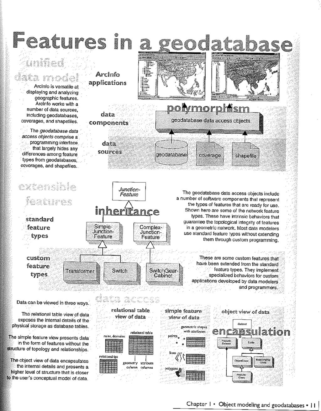
 Feature dataset Spatial reference Object (non-spatial)")

10 Within a geodatabase (pg. 9) Feature dataset Spatial reference Object (non-spatial) classes Feature (spatial) classes Relationship classes Geometric networks Planar topologies Domains Validation rules Raster datasets TIN datasets Locators
11 Key components of OO Polymorphism Behaviors of an object class can adapt to variations of objects (draw, add, delete of geodatabase, coverage, shapefile) Encapsulation An object is accessed through well-defined software methods, hiding the internal details (drawback is interoperability with other software) Inheritance An object class can be defined to include the features of another object class, plus additional behaviors
12
 Can model topologically integrated datasets (i.e. networks) Can define relationships between objects and features Can enforce attribute integrity Can bind")
13 Serving geographic data All data is stored in an RDBMS through enhancement How does Geodatabase extend an RDBMS Represents 4 types of geo data (raster, vector, address, TIN) Stores shapes of features, coordinate systems (no more.prj) Can model topologically integrated datasets (i.e. networks) Can define relationships between objects and features Can enforce attribute integrity Can bind natural feature behavior to feature tables Can present multiple versions of data Personal vs. multiuser geodatabases ArcInfo vs. ArcSDE Both systems interact with the geodatabase

14 Building a data model Designing a logical data model Representing logical data model Implementing physical database model
15 Classes and Objects Abstract class Cannot be used to create new objects Is a specification for subclasses (i.e. a line is an abstract class for a secondary or primary line) Creatable class Objects you can directly create Instantiable class Cannot directly create new objects Objects created as functions of other objects
16 Types of Relationships Associations relationships between classes Multiplicity constraint on associations 1 1 and only 1 (default) 0..1 Zero or one M..N from M to N (positive integers) * or 0..* - from zero to any positive integer 1..* - from 1 to any positive integer Type inheritance classes that share properties with superclass and have additional properties Instantiation one object from one class can create an object from another class Aggregation asymmetric; object of one class is whole another is parts Composition stronger aggregation; objects from the whole class controls the lifetime of the parts class
Introduction to ArcCatalog
 Introduction to ArcCatalog Introduction To Arc Catalog ArcCatalog is a data- centric GUI tool used for managing spatial data With ArcCatalog you can. Inspect properties and attributes of data Preview and
LSGI 521: Principles of GIS. Lecture 5: Spatial Data Management in GIS. Dr. Bo Wu
 Lecture 5: Spatial Data Management in GIS Dr. Bo Wu lsbowu@polyu.edu.hk Department of Land Surveying & Geo-Informatics The Hong Kong Polytechnic University Contents 1. Learning outcomes 2. From files to
Using the Geodatabase
 Using the Geodatabase February 13, 2002 Presented by: John Stroud, ESRI GeoDatabase Geodatabase comes in two flavors Personal mdb format ArcSDE rdbms format ArcGIS is a suite of three products ArcView,
SPATIAL DATA MODELS Introduction to GIS Winter 2015
 SPATIAL DATA MODELS Introduction to GIS Winter 2015 GIS Data Organization The basics Data can be organized in a variety of ways Spatial location, content (attributes), frequency of use Come up with a system
Introduction to Geodatabase and Spatial Management in ArcGIS. Craig Gillgrass Esri
 Introduction to Geodatabase and Spatial Management in ArcGIS Craig Gillgrass Esri Session Path The Geodatabase - What is it? - Why use it? - What types are there? - What can I do with it? Query Layers
Topic 5: Raster and Vector Data Models
 Geography 38/42:286 GIS 1 Topic 5: Raster and Vector Data Models Chapters 3 & 4: Chang (Chapter 4: DeMers) 1 The Nature of Geographic Data Most features or phenomena occur as either: discrete entities
Topology in the Geodatabase: An Introduction
 Topology in the Geodatabase: An Introduction Colin Zwicker Erik Hoel ESRI Super Secret Topology Laboratory, May 2016 Agenda ArcGIS Topology defined Validating a topology Editing a topology Geoprocessing
Why use an RDBMS? ❽ Data maintenance ❽ Standardized access ❽ Multi-user access ❽ Data protection
 1 Why use an RDBMS? ❽ Data maintenance ❽ Standardized access ❽ Multi-user access ❽ Data protection 2 RDBMSs offer Data protection ❽ Recovery ❽ Concurrency ❽ Security 3 Data protection ❽ Recovery from ❽
Introduction to ArcSDE 8. John Calkins
 Introduction to ArcSDE 8 John Calkins Why are you here? Introduction to ArcSDE? What is a GeoDatabase? Existing SDE user? Existing ArcInfo user? Technical details on implementation? Just confused... ArcSDE
Streamlining Editing Workflows. Amber Bethell
 Streamlining Editing Workflows Amber Bethell Workflow for solving geographic problems Ask a question Create or acquire data Validate and update data Analyze data Create cartographic product Act upon knowledge
Maps as Numbers: Data Models
 Maps as Numbers: Data Models vertices E Reality S E S arcs S E Conceptual Models nodes E Logical Models S Start node E End node S Physical Models 1 The Task An accurate, registered, digital map that can
Coverage data model. Vector-Based Spatial Analysis: Tools Processes. Topological Data Model. Polygons Files. Geographic Information Systems.
 GEOG4340 Geographic Information Systems Lecture Four 2013winter Vector-Based Spatial Analysis: Tools Processes Reading materials: Chapter 6 of Intro GIS by J. R. Jensen and R.R. Jensen Cheng. Q., Earth
ArcMap - EXPLORING THE DATABASE Part I. SPATIAL DATA FORMATS Part II
 Week 5 ArcMap - EXPLORING THE DATABASE Part I SPATIAL DATA FORMATS Part II topics of the week Exploring the Database More on the Table of Contents Exploration tools Identify, Find, Measure, Map tips, Hyperlink,
Esri s ArcGIS Enterprise. Today s Topics. ArcGIS Enterprise. IT4GIS Keith T. Weber, GISP GIS Director ISU GIS Training and Research Center
 Esri s ArcGIS Enterprise IT4GIS Keith T. Weber, GISP GIS Director ISU GIS Training and Research Center Today s Topics Part 1: ArcGIS Enterprise architecture Part 2: Storing and serving data for the enterprise
Topology in the Geodatabase an Introduction. Erik Hoel Doug Morgenthaler
 Topology in the Geodatabase an Introduction Erik Hoel Doug Morgenthaler ESRI Super Secret Topology Laboratory, May 2012 Agenda ArcGIS Topology defined Validating a topology Editing a topology Geoprocessing
Geog 469 GIS Workshop. System Requirements - Data
 Geog 469 GIS Workshop System Requirements - Data Outline 1. What are some principles of project management? 2. What are some fundamental issues associated with system requirements? 3. What are some issues
Geodatabase and Object Model Design Using CASE Tools. Julio Andrade Erik Hoel
 Geodatabase and Object Model Design Using CASE Tools Julio Andrade Erik Hoel Goals Develop an understanding of when to use CASE versus ArcCatalog how to represent data models in UML how to run the schema
Using ESRI data in Autodesk ISD Products
 GI13-3 Using ESRI data in Autodesk ISD Products 1.5 hr. Class 02-Dec-03 3:30pm - 5:00pm Session Description: We will focus on using data in a variety of ESRI formats within the Autodesk GIS product line,
Spatial Analysis (Vector) II
 II") Spatial Analysis (Vector) II GEOG 300, Lecture 9 Dr. Anthony Jjumba 1 A Spatial Network is a set of geographic locations interconnected in a system by a number of routes is a system of linear features
Spatial Analysis (Vector) II GEOG 300, Lecture 9 Dr. Anthony Jjumba 1 A Spatial Network is a set of geographic locations interconnected in a system by a number of routes is a system of linear features
Esri s Spatial Database Engine. Today s Topics. ArcSDE. A spatial database engine that works on
 Esri s Spatial Database Engine IT4GIS Keith T. Weber, GISP GIS Director ISU GIS Training and Research Center Today s Topics Part 1: What is ArcSDE? Why use ArcSDE? ArcSDE Data Structure How is data stored
ENGRG 59910: Introduction to GIS
 ENGRG 59910: Introduction to GIS Lecture 05: GIS and Databases Basics Acknowledgment: Michael Piasecki Where are we now? Basic geographic concepts Introduction to GIS, coordinate system, projection, datum
layers in a raster model
 layers in a raster model Layer 1 Layer 2 layers in an vector-based model (1) Layer 2 Layer 1 layers in an vector-based model (2) raster versus vector data model Raster model Vector model Simple data structure
Key Terms. Attribute join Target table Join table Spatial join
 Key Terms Attribute join Target table Join table Spatial join Lect 10A Building Geodatabase Create a new file geodatabase Map x,y data Convert shape files to geodatabase feature classes Spatial Data Formats
Copyright The McGraw-Hill Companies, Inc. Permission required for reproduction or display.
 Chapter 8. ATTRIBUTE DATA INPUT AND MANAGEMENT 8.1 Attribute Data in GIS 8.1.1 Type of Attribute Table 8.1.2 Database Management 8.1.3 Type of Attribute Data Box 8.1 Categorical and Numeric Data 8.2 The
PUG List. Raster Analysis 3D Analysis Geoprocessing. Steve Kopp
 PUG List Raster Analysis 3D Analysis Geoprocessing Steve Kopp Contour Polygons Spatial Analyst - color-filled contours. Similar to thematic classification, where blue = -1000 to zero, and red = 0 to +1000,
Linear Referencing in ArcGIS : Practical Considerations for the Development of an Enterprisewide GIS
 Linear Referencing in ArcGIS : Practical Considerations for the Development of an Enterprisewide GIS An ESRI Technical Paper April 2003 ESRI 380 New York St., Redlands, CA 92373-8100, USA TEL 909-793-2853
Forestry Data Model User Guide. Version 2.0 January, 2013
 Forestry Data Model User Guide Version 2.0 January, 2013 Table of Contents Introduction... 1 Advantages of Using a Geodatabase... 1 Subtypes and Domains... 2 Subtypes... 2 Domains... 3 The Forestry Data
What's New in ArcGIS 9.2 Service Packs
 What's New in ArcGIS 9.2 Service Packs 18 July 2007 Updated for Service Pack 3 This document describes the main enhancements to 9.2 added by the service packs. It does not cover the bug fixes and quality
Watershed Modeling With Feature Objects
 Watershed Modeling With Feature Objects Lesson 4 4-1 Objectives Apply the rules of feature object topology to create a drainage coverage 4-2 Work Flow This lesson covers the use of feature objects for
GEOSPATIAL ENGINEERING COMPETENCIES. Geographic Information Science
 GEOSPATIAL ENGINEERING COMPETENCIES Geographic Information Science The character and structure of spatial information, its methods of capture, organisation, classification, qualification, analysis, management,
Class #2. Data Models: maps as models of reality, geographical and attribute measurement & vector and raster (and other) data structures
 data structures") Class #2 Data Models: maps as models of reality, geographical and attribute measurement & vector and raster (and other) data structures Role of a Data Model Levels of Data Model Abstraction GIS as Digital
Class #2 Data Models: maps as models of reality, geographical and attribute measurement & vector and raster (and other) data structures Role of a Data Model Levels of Data Model Abstraction GIS as Digital
Maps as Numbers: Data Models
 Maps as Numbers: Data Models vertices nodes tart node nd node arcs Reality Conceptual Models The Task An accurate, registered, digital map that can be queried and analyzed Translate: Real World Locations,
Name: Date: June 27th, 2011 GIS Boot Camps For Educators Lecture_3
 Name: Date: June 27th, 2011 GIS Boot Camps For Educators Lecture_3 Practical: Creating and Editing Shapefiles Using Straight, AutoComplete and Cut Polygon Tools Use ArcCatalog to copy data files from:
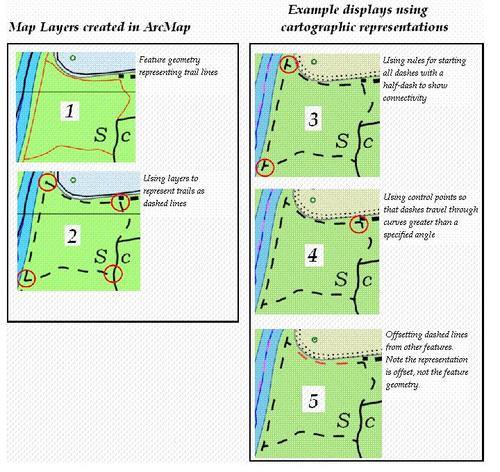
Slide 1. Advanced Cartography in ArcGIS. Robert Jensen Edie Punt. Technical Workshops
 Slide 1 Technical Workshops Advanced Cartography in ArcGIS Robert Jensen Edie Punt Slide 2 Overview Using representations to manage symbology Solving graphic conflicts Geoprocessing for cartography in
The Geodatabase. Chase T. Brooke Ecosystem Science and Management Texas A&M University College StaOon, TX
 The Geodatabase Chase T. Brooke Ecosystem Science and Management Texas A&M University College StaOon, TX 77843 cbrooke@tamu.edu EvoluOon of the acronym GIS SpaOal Thinking IdenOfying, analyzing, and understanding
Lab.4 & Assignment 2. Lab4. Conversion of Hardcopy Map to ArcGIS Map
 EATS4400 GIS Lab.4 & Assignment 2 Lab4 Conversion of Hardcopy Map to ArcGIS Map In this lab exercise you will have chance to go through the steps to convert hardcopy map into digital map for ArcGIS. Digitizing
SVY2001: Databases for GIS
 SVY2001: Databases for GIS Lecture 15: Introduction to GIS and Attribute Data Management. Dr Stuart Barr School of Civil Engineering & Geosciences University of Newcastle upon Tyne. Email: S.L.Barr@ncl.ac.uk
Welcome to NR402 GIS Applications in Natural Resources. This course consists of 9 lessons, including Power point presentations, demonstrations,
 Welcome to NR402 GIS Applications in Natural Resources. This course consists of 9 lessons, including Power point presentations, demonstrations, readings, and hands on GIS lab exercises. Following the last
An Example of Regional Web Resources: Massachusetts, USA Digital Data
 An Example of Regional Web Resources: Massachusetts, USA Digital Data Author Attribution Major contributors to this curriculum include (alphabetical): Maria Fernandez Michael Hamel Quentin Lewis Maili
ENGRG Introduction to GIS
 ENGRG 59910 Introduction to GIS Michael Piasecki October 06, 2017 Lecture 05: GIS and Database Basics Where are we now? Basic geographic concepts Introduction to GIS, coordinate system, projection, datum
ArcView QuickStart Guide. Contents. The ArcView Screen. Elements of an ArcView Project. Creating an ArcView Project. Adding Themes to Views
 ArcView QuickStart Guide Page 1 ArcView QuickStart Guide Contents The ArcView Screen Elements of an ArcView Project Creating an ArcView Project Adding Themes to Views Zoom and Pan Tools Querying Themes
The GIS Spatial Data Model
 The GIS Spatial Data Model Introduction: Spatial data are what drive a GIS. Every piece of functionality that makes a GIS separate from another analytical environment is rooted in the spatially explicit
ENGRG Introduction to GIS
 ENGRG 59910 Introduction to GIS Michael Piasecki October 5, 2014 Lecture 05: GIS and Databases Basics Where are we now? Basic geographic concepts Introduction to GIS, coordinate system, projection, datum
4.0 DIGITIZATION, EDITING AND STRUCTURING OF MAP DATA
 .0 DIGITIZATION, EDITING AND STRUCTURING OF MAP DATA The process of digitizing existing maps is a transformation from one analog) form of information to another digital) form. Data input is the operation
Utility Network Management in ArcGIS: Migrating Your Data to the Utility Network. John Alsup & John Long
 Utility Network Management in ArcGIS: Migrating Your Data to the Utility Network John Alsup & John Long Presentation Outline Utility Network Preparation - Migration Patterns - Understanding the Asset Package
Introducing ArcScan for ArcGIS
 Introducing ArcScan for ArcGIS An ESRI White Paper August 2003 ESRI 380 New York St., Redlands, CA 92373-8100, USA TEL 909-793-2853 FAX 909-793-5953 E-MAIL info@esri.com WEB www.esri.com Copyright 2003
DATA MODELS IN GIS. Prachi Misra Sahoo I.A.S.R.I., New Delhi
 DATA MODELS IN GIS Prachi Misra Sahoo I.A.S.R.I., New Delhi -110012 1. Introduction GIS depicts the real world through models involving geometry, attributes, relations, and data quality. Here the realization
17/07/2013 RASTER DATA STRUCTURE GIS LECTURE 4 GIS DATA MODELS AND STRUCTURES RASTER DATA MODEL& STRUCTURE TIN- TRIANGULAR IRREGULAR NETWORK
 RASTER DATA STRUCTURE GIS LECTURE 4 GIS DATA MODELS AND STRUCTURES Space is subdivided into regular grids of square grid cells or other forms of polygonal meshes known as picture elements (pixels) the
Answer the following general questions: 1. What happens when you right click on an icon on your desktop? When you left double click on an icon?
 Name: Date: June 27th, 2011 GIS Boot Camps For Educators Practical: Explore ArcGIS 10 Desktop Tools and functionality Day_1 Lecture 1 Sources: o ArcGIS Desktop help o ESRI website o Getting to Know ArcGIS
Announcements. Data Sources a list of data files and their sources, an example of what I am looking for:
 Data Announcements Data Sources a list of data files and their sources, an example of what I am looking for: Source Map of Bangor MEGIS NG911 road file for Bangor MEGIS Tax maps for Bangor City Hall, may
Lab 1: Exploring data format
 Geog 458: Map Sources and Errors January 13, 2006 Lab 1: Exploring data format Data format supported by ArcGIS There are many file types supported by ArcGIS, in addition to specific cartographic objects.
George Mason University Department of Civil, Environmental and Infrastructure Engineering. Dr. Celso Ferreira Prepared by Lora Baumgartner
 George Mason University Department of Civil, Environmental and Infrastructure Engineering Dr. Celso Ferreira Prepared by Lora Baumgartner Exercise Topic: Getting started with HEC GeoRAS Objective: Create
Oracle Spatial A Unifying Framework at the Utah Department Of Transportation
 Oracle Spatial A Unifying Framework at the Utah Department Of Transportation Dan Paske Utah Department of Transportation Oracle DBA Jeff Saunders Farallon Geographics, Inc. Senior Geodatabase Developer
Understanding ArcSDE. GIS by ESRI
 Understanding ArcSDE GIS by ESRI Copyright 1999, 2001 2002 ESRI All rights reserved Printed in the United States of America The information contained in this document is the exclusive property of ESRI
Chapter 3: Maps as Numbers
 Chapter 3: Maps as Numbers 3. Representing Maps as Numbers 3.2 Structuring Attributes 3.3 Structuring Maps 3.4 Why Topology Matters 3.5 Formats for GIS Data 3.6 Exchanging Data David Tenenbaum EEOS 265
Computer Database Structure for Managing Data :-
 The Map as an Abstraction of Space :- We begin the process of abstraction by conceptualizing what we encounter as a group of points, lines, areas and surfaces. We make decision about which object to take
Algorithms for GIS csci3225
 Algorithms for GIS csci3225 Laura Toma Bowdoin College Spatial data types and models Spatial data in GIS satellite imagery planar maps surfaces networks point cloud (LiDAR) Spatial data in GIS satellite
Representing Geography
 Data models and axioms Chapters 3 and 7 Representing Geography Road map Representing the real world Conceptual models: objects vs fields Implementation models: vector vs raster Vector topological model
Geog 469 GIS Workshop. System Requirements
 Geog 469 GIS Workshop System Requirements Outline 1. What are some fundamental issues associated with system requirements? 2. What are your GIS data requirements? 3. What are your GIS software requirements?
The Geodatabase. A. Michelle Lawing Ecosystem Science and Management Texas A&M University College StaMon, TX
 The Geodatabase A. Michelle Lawing Ecosystem Science and Management Texas A&M University College StaMon, TX 77843 alawing@tamu.edu EvoluMon of the acronym GIS SpaMal Thinking IdenMfying, analyzing, and
Accessing and Administering your Enterprise Geodatabase through SQL and Python
 Accessing and Administering your Enterprise Geodatabase through SQL and Python Brent Pierce @brent_pierce Russell Brennan @russellbrennan hashtag: #sqlpy Assumptions Basic knowledge of SQL, Python and
Vector Data. James Frew ESM 263 Winter
 Vector Data 1 Why Vector Data? Recall: features vs fields features: discrete enffes with specific locafons fields: confnuous funcfons of (x, y) Vector is GIS-speak for feature representafons dimensionality:
ER-to-Relational Mapping
 Lecture 9 1 1. Context 2. The Algorithm Outline 2 Database Design and Implementation Process 3 Data Models 4 Example ERD 5 Resulting Relational Schema 6 Step 1: Regular Entity Types i. For each regular/strong
Design a Geodatabase. Rasu Muthurakku, Enterprise Solutions Architect / Consultant
 Rasu Muthurakku, Enterprise Solutions Architect / Consultant Agenda Overview Key Factors Design - Recommendations Key Considerations, Best Practices and Recommendations / Lessons Learned! Overview What
What s New in TerraExplorer Suite 5.0
 What s New in TerraExplorer Suite 5.0 The new release of the TerraExplorer Suite marks major improvements in the capabilities for working with GIS layers. A new streaming mechanism allows connection to
ArcGIS Pro Editing. Jennifer Cadkin & Phil Sanchez
 ArcGIS Pro Editing Jennifer Cadkin & Phil Sanchez ArcGIS Pro Editing Overview Provides tools that allow you to maintain, update, and create new data - Modifying geometry, drawing new features - Entering
Algorithms for GIS. Spatial data: Models and representation (part I) Laura Toma. Bowdoin College
 Laura Toma. Bowdoin College") Algorithms for GIS Spatial data: Models and representation (part I) Laura Toma Bowdoin College Outline Spatial data in GIS applications Point data Networks Terrains Planar maps and meshes Data structures
Algorithms for GIS Spatial data: Models and representation (part I) Laura Toma Bowdoin College Outline Spatial data in GIS applications Point data Networks Terrains Planar maps and meshes Data structures
Analytical and Computer Cartography Winter Lecture 9: Geometric Map Transformations
 Analytical and Computer Cartography Winter 2017 Lecture 9: Geometric Map Transformations Cartographic Transformations Attribute Data (e.g. classification) Locational properties (e.g. projection) Graphics
Exploring GIS Data. I) GIS Data Models-Definitions II) Database Management System III) Data Source & Collection IV) Data Quality
 GIS Data Models-Definitions II) Database Management System III) Data Source & Collection IV) Data Quality") Exploring GIS Data I) GIS Data Models-Definitions II) Database Management System III) Data Source & Collection IV) Data Quality 1 Geographic data Model Definitions: Data : A collection of related facts
Exploring GIS Data I) GIS Data Models-Definitions II) Database Management System III) Data Source & Collection IV) Data Quality 1 Geographic data Model Definitions: Data : A collection of related facts
Multidimensional Data and Modelling - DBMS
 Multidimensional Data and Modelling - DBMS 1 DBMS-centric approach Summary: l Spatial data is considered as another type of data beside conventional data in a DBMS. l Enabling advantages of DBMS (data
v TUFLOW-2D Hydrodynamics SMS Tutorials Time minutes Prerequisites Overview Tutorial
 v. 12.2 SMS 12.2 Tutorial TUFLOW-2D Hydrodynamics Objectives This tutorial describes the generation of a TUFLOW project using the SMS interface. This project utilizes only the two dimensional flow calculation
Data Models and Data processing in GIS
 PDHonline Course L155G (5 PDH) Data Models and Data processing in GIS Instructor: Steve Ramroop, Ph.D. 2012 PDH Online PDH Center 5272 Meadow Estates Drive Fairfax, VA 22030-6658 Phone & Fax: 703-988-0088
Advanced Database Applications. Object Oriented Database Management Chapter 13 10/29/2016. Object DBMSs
 Object Oriented Database Chapter 13 1 Object DBMSs Underlying concepts: Freely sharing data across processing routines creates unacceptable data dependencies All software should be constructed out of standard,
Cartographic Techniques and Representations
 Cartographic Techniques and Representations NEARC 2007 ESRI Technical Session ESRI, Boston Overview of Presentation Labeling and Annotation Masking Layout Tips Cartographic Representations Labeling versus
Editing Versioned Geodatabases : An Introduction
 Esri International User Conference San Diego, California Technical Workshops July 24, 2012 Editing Versioned Geodatabases : An Introduction Cheryl Cleghorn Shawn Thorne Assumptions: Basic knowledge of
What s New in Desktop 10.1
 What s New in Desktop 10.1 Damian Spangrud Esri Redlands Trip Down Memory Lane ArcGIS A Complete System for Geographic Information Cloud Web Online Mobile Enterprise Desktop Sharing Information sharing
Introduction to ArcGIS I
 Introduction 1-1 What is ArcGIS? ArcGIS Clients ArcReader E X T E N S I O N S ArcGIS Desktop ArcView ArcEditor ArcInfo ArcGIS Engine ArcPad Custom Application E X T E N S I O N S Web Browser Components
New Jersey Statewide Transportation Data Model. Mark Gulbinsky November 5, 2004 NJDOT
 Statewide Transportation Data Model Mark Gulbinsky November 5, 2004 NJDOT Presenter Mark Gulbinsky NJDOT BIMTP/GIS Unit Mark.Gulbinsky@dot.state.nj.us 609-530-3097 Statewide Transportation Data Models
GEOGRAPHIC INFORMATION SYSTEMS Lecture 17: Geoprocessing and Spatial Analysis
 GEOGRAPHIC INFORMATION SYSTEMS Lecture 17: and Spatial Analysis tools are commonly used tools that we normally use to prepare data for further analysis. In ArcMap, the most commonly used tools appear in
Lecture 6: GIS Spatial Analysis. GE 118: INTRODUCTION TO GIS Engr. Meriam M. Santillan Caraga State University
 Lecture 6: GIS Spatial Analysis GE 118: INTRODUCTION TO GIS Engr. Meriam M. Santillan Caraga State University 1 Spatial Data It can be most simply defined as information that describes the distribution
Facilities Management Data Input, Editing and Management. Adrien Litton
 Facilities Management Data Input, Editing and Management Adrien Litton Overview What is FM in GIS? Data input Data editing Data management Supporting the Real Property Life-Cycle GIS Integrates the Facility
What's New in ArcGIS 9.2 Service Packs
 What's New in ArcGIS 9.2 Service Packs 8 July 2008 Updated for Service Pack 6 This document describes the main enhancements to 9.2 added by the service packs. It does not cover the bug fixes and quality
ArcScan. for ArcGIS. GIS by ESRI
 ArcScan for ArcGIS GIS by ESRI Copyright 2002 ESRI All rights reserved Printed in the United States of America The information contained in this document is the exclusive property of ESRI This work is
ArcGIS 9 Understanding ArcSDE
 ArcGIS 9 Understanding ArcSDE Copyright 1999 2005 ESRI All rights reserved. Printed in the United States of America. The information contained in this document is the exclusive property of ESRI. This work
ArcGIS Runtime SDK for ios and macos: Building Apps. Suganya Baskaran, Gagandeep Singh
 ArcGIS Runtime SDK for ios and macos: Building Apps Suganya Baskaran, Gagandeep Singh Get Started Core Components Agenda - Display Map Content - Search for Content - Perform Analysis - Edit Content Summary
M. Andrea Rodríguez-Tastets. I Semester 2008
 M. -Tastets Universidad de Concepción,Chile andrea@udec.cl I Semester 2008 Outline refers to data with a location on the Earth s surface. Examples Census data Administrative boundaries of a country, state
Lecture 7 Digitizing. Dr. Zhang Spring, 2017
 Lecture 7 Digitizing Dr. Zhang Spring, 2017 Model of the course Using and making maps Navigating GIS maps Map design Working with spatial data Geoprocessing Spatial data infrastructure Digitizing File
TOPOLOGICAL CONSTRAINTS, ACTIONS AND REFLEXES FOR GENERALIZATION BY OPTIMIZATION
 10 th ICA Workshop on Generalisation and Multiple Representation, 2-3 August 2007, Moscow TOPOLOGICAL CONSTRAINTS, ACTIONS AND REFLEXES FOR GENERALIZATION BY OPTIMIZATION Jean-Luc Monnot, Paul Hardy, &
Using Middleware to Provide Geographic Information Systems (GIS) Based on Relational Databases
 Based on Relational Databases") Using Middleware to Provide Geographic Information Systems (GIS) Based on Relational Databases Andrew Cardno, Kelly Buchanan & Dr Pete Frizzell PO Box 4103, WELLINGTON Phone [64] (4) 472-8244 email: andrew@critchlow.co.nz
Using Middleware to Provide Geographic Information Systems (GIS) Based on Relational Databases Andrew Cardno, Kelly Buchanan & Dr Pete Frizzell PO Box 4103, WELLINGTON Phone [64] (4) 472-8244 email: andrew@critchlow.co.nz
Objectives Learn how to work with projections in SMS, and how to combine data from different coordinate systems into the same SMS project.
 v. 12.2 SMS 12.2 Tutorial Working with map projections in SMS Objectives Learn how to work with projections in SMS, and how to combine data from different coordinate systems into the same SMS project.
TABLES, ANATOMY OF A TABLE
 week 6 TABLES, ANATOMY OF A TABLE topics of the week Table structure Working with tables Table relationships Cardinality, Joins and Relates Table Jargon What is a Database? What is a Table? What is a Record/Row?
Objectives This tutorial will introduce how to prepare and run a basic ADH model using the SMS interface.
 v. 12.1 SMS 12.1 Tutorial Objectives This tutorial will introduce how to prepare and run a basic ADH model using the SMS interface. Prerequisites Overview Tutorial Requirements ADH Mesh Module Scatter
Lecturer 2: Spatial Concepts and Data Models
 Lecturer 2: Spatial Concepts and Data Models 2.1 Introduction 2.2 Models of Spatial Information 2.3 Three-Step Database Design 2.4 Extending ER with Spatial Concepts 2.5 Summary Learning Objectives Learning
Object-Oriented Design
 Object-Oriented Design IT4GIS Keith T. Weber, GISP GIS Director ISU GIS Training and Research Center Topics During the balance of this semester, we will pursue and follow two learning threads Object-relational
Objectives Learn how to work with projections in GMS, and how to combine data from different coordinate systems into the same GMS project.
 v. 10.2 GMS 10.2 Tutorial Working with map projections in GMS Objectives Learn how to work with projections in GMS, and how to combine data from different coordinate systems into the same GMS project.
Chapter 17 Creating a New Suit from Old Cloth: Manipulating Vector Mode Cartographic Data
 Chapter 17 Creating a New Suit from Old Cloth: Manipulating Vector Mode Cartographic Data Imagine for a moment that digital cartographic databases were a perfect analog of the paper map. Once you digitized
GEOGRAPHIC INFORMATION SYSTEMS Lecture 02: Feature Types and Data Models
 GEOGRAPHIC INFORMATION SYSTEMS Lecture 02: Feature Types and Data Models Feature Types and Data Models How Does a GIS Work? - a GIS operates on the premise that all of the features in the real world can
Feature Analyst Quick Start Guide
 Feature Analyst Quick Start Guide Change Detection Change Detection allows you to identify changes in images over time. By automating the process, it speeds up a acquisition of data from image archives.
CPSC 695. Data Quality Issues M. L. Gavrilova
 CPSC 695 Data Quality Issues M. L. Gavrilova 1 Decisions Decisions 2 Topics Data quality issues Factors affecting data quality Types of GIS errors Methods to deal with errors Estimating degree of errors
Element: Relations: Topology: no constraints.
 The Module Viewtype The Module Viewtype Element: Elements, Relations and Properties for the Module Viewtype Simple Styles Call-and-Return Systems Decomposition Style Uses Style Generalization Style Object-Oriented