5. Modelling and models. Sisi Zlatanova
|
|
|
- Emily Blair
- 5 years ago
- Views:
Transcription

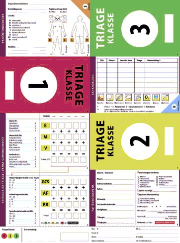
1 5. Modelling and models Sisi Zlatanova
2 Content Investigation of data used in Emergency response Operational data models Models for Navigation and Evacuation
3 Existing data Very often they have a model (even UML) Maintained with the source Accessed via Web services, BPEL applications, Groove (MS collaboration software program) Standards for schema and data exchange (OGC) Initiatives for data harmonisation: INSPIRE,..
4 Operational data No models (In large extends not structured data) Maintained by municipality, safety region, province, NCC Access: Web services, BPEL applications, Groove (MS collaboration software program) Initiatives for standards: Common Alert Protocol (CAP), several EU project Little initiatives for data harmonisation.


5 Information modelling in the Netherlands Generic Sector specific Organisation specific
6 Operational (dynamic) data: steps to record data 1. Activities, Users, Tasks have to be defined (to be able to identify the information to be persistently stored) 2. Formal modelling (UML, ontology) 3. Spatio-temporal data model (approach to record information with respect to geometry and time) 4. Storage?: DBMS based vs. file-based approach, DBMS (commercial vs. open-source)
7 Modelling of process 5: Measurements and observations 1. Centralist receives location 2. Places sector template 3. Direction of the wind 4. Measuring teams 5. Creation of plume
8 Forms to perform measurements in the affected area Measuring order leader-mpo DTG: Measuring team Whiskey Sectorenmal Coordinates of incident Oscar 1 Sectors Oscar 2 measurement location (coordinates) Mike Type measurement Info about exclusivity Echo Measuring pipes Bravo Electrical instruments Romeo Electrical instruments 2 Romeo-sierra Personal detectors Delta Personal protection Ademlucht Time order Tango
9 Formal modeling using UML: Activity, use case diagrams
10 Needed dynamic spatial information Incident location of incident type of incident (?) scale of incident Effects and consequences size of affected area development of the incident threatened area (+time/period) escalation possibility Surroundings of the incident sectormal damaged infrastructure damaged utilities damaged special objects current and predicted meteorological info wind direction wind speed precipitation (rain/snow) temperature humidity Accessibility in- and out-routes traffic direction (possible) blocked roads Victims number of casualties number of dead number of missing number of found people number of trapped
")
11 Spatial information created by Process 5 Source location Affected area Threatened area Scale of incident Type of incident Development of incident Sector diagram Measurements (according to the specialised forms) Plume
12 Processes, Units, Actors, Tasks Needed and produced temporal data
13 Process 1: fire fighting
14 Process 1: fire fighting

15 Process 1: fire fighting Buildings Roads Streets Rivers
16 Content Investigation of data used in Emergency response Operational data models Models for Navigation and Evacuation
 Damages victims Records,")
17 Integrated conceptual data model Points, Lines, polygons, (video) Damages victims Records, measurements

18 Class diagrams for the data model Information is organised per incident Centralized storage DBMS

19 Information used by the fire brigade
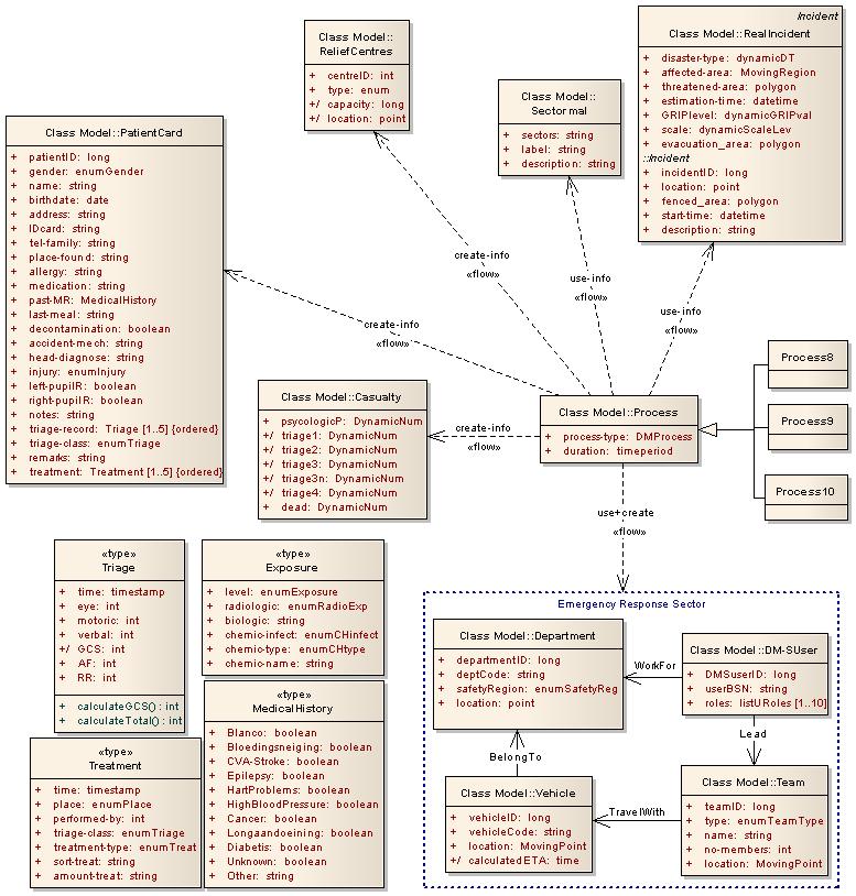
20 Information used by medical help
21 A large number of can be executed find police vehicles that are in a radius of 5km from the incident which car is the closest to the incident? calculate the speed of expansion of the gas plume; evaluate the evacuation area for the next 8 hours from the area covered by the current gas plume and the prediction; calculate a route, which does not overlap with the gas plume; find the location of all the fire brigade teams; give the locations of the measurement teams; give information that has been available 2 ours after the incident has taken place; when the fire brigade/ambulance arrived at the place of incident?; what is the size of the affected area?; give number of injuries/damages/ 4 hours after the incident has taken place; how many people of the police sector are involved? and so on.

22 Examples Show the trajectories of teams with ID11 to ID16 Show the trajectories in the last 2 hours

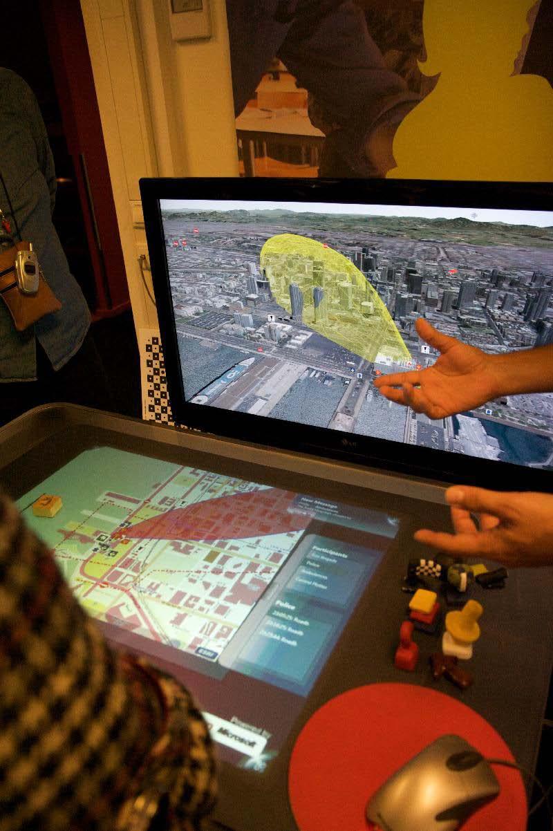
23 Visualisation (Geodan)
24 Not in the model: GRIP 3,4
25 Not in the model: Actors that are not primary emergency response units Information specific for a type of disaster (e.g. water level) Sensor information (any kinds of sensors) Physical models for prediction and simulation Moving objects some more limitations in geometry representations
26 Border security use case (illustration of moving objects) Intruder enter EU and is detected by a kind of sensor Police attempts to follow them Equipped with all kinds of sensors (GPS, camera, motion detectors
27 Formal modelling: UML class diagram
28 NATO: LAND C2 INFORMATION EXCHANGE DATA MODEL
29 Operational models Many problems are expected: Modelling just starts (many models already exist) Needed information is not clear (like for example for topographic maps or cadastre) Used information comes from many different sources (many formats) Semantic differences (DM is practically a combination of several application domains).
30 Content Investigation of data used in Emergency response Operational data models Models for Navigation and Evacuation
31 Existing navigation systems... Positions (and tasks) of other teams are unknown=>cooperation between them cannot be taken into consideration Accessibility of roads is unknown The road network is predefined Changing environment is not considered Tracking is possible (and done) but only monitored and not analysed
32 Factors influencing navigation in emergency response (1/2) Spatial information: roads, paths, pedestrian areas, etc... Users' information: task, personal data (age, gender, disabilities), equipment (personal devices) and location. Event (threat) information: information about development of disaster

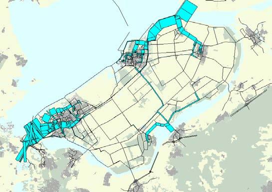
33 Find the optimal way considering the dynamic situation Picture: Ivo Visser How close? Picture: Eagle


34 Find the optimal way considering the dynamic situation Mioc, Anton, Liang, 2008
35 Factors influencing navigation in emergency response (2/2) One or multiple moving objects One or multiple target points (which can be also moving objects) Cost function: 'optimal' path (shortest distance, fastest route, safe route, comfortable route)
36 Six navigation cases 1:1s, an ambulance to a hospital 1:1s(?), an ambulance to the 'best' hospital 1:Ms, a truck carrying first aid supplement to many shelters M:1s, many fire trucks to one fire M:Ms, many ambulances to different hospitals M:1d, find a place for meeting of MO/catch criminals M:Md, evacuation of many responders to many moving places s-static point; d-dynamic point
37 Spatio-temporal Model (1/2) Four packages Network (Route) class
38 Spatio-temporal Model (2/2) Event class User class
39 DBMS: 1:1s select gid,the_geom from shortest_path_as_geometry('tudelft_street',981,1197); Dijkstra algorithm shortest distance


40 A Key Problem:3D Navigation New York, Google Earth Integrated Indoor and Outdoor Navigation Personalized 3D Representation


41 Indoor network model from Building Information Models Wall Corridor Static Network BIM Model Slab Doors & Windows Navigable Network Stair Li Yuan, Xiamen University

42 Evacuation models 26, 20, 17 hours Zuilekom, Zuidgeest, 2008
43 Summary Modelling is critical for entire DM chain Better understanding of data Matching between different data set for integration (model-driven approach, match models and not data) Exchange of information between different applications/users Archiving of operation data for future analysis Simulation and prediction Modeling helps in developing context-aware applications.
Next Generation Disaster Data Infrastructure
 Next Generation Disaster Data Infrastructure 25-1-2016 Sisi Zlatanova Associate professor at 3DGEoinformation, Urbanism Member of the SC of IRDR, Co-chair DATA Chair WG ISPRS IV/7 3Dindoor modelling and
Spatiotemporal Data Modeling for Disaster Management in the Netherlands
 Spatiotemporal Data Modeling for Disaster Management in the Netherlands Arta Dilo A.Dilo@tudelft.nl Delft University of Technology, Jaffalaan 9, 2628 BX Delft, The Netherlands Sisi Zlatanova S.Zlatanova@tudelft.nl
Georeferencing. Georeferencing: = linking a layer or dataset with spatial coordinates. Registration: = lining up layers with each other
 Georeferencing How do we make sure all our data layers line up? Georeferencing: = linking a layer or dataset with spatial coordinates Registration: = lining up layers with each other Rectification: The
White Paper: Next generation disaster data infrastructure CODATA LODGD Task Group 2017
 White Paper: Next generation disaster data infrastructure CODATA LODGD Task Group 2017 Call for Authors This call for authors seeks contributions from academics and scientists who are in the fields of
GIS in Situational and Operational Awareness: Supporting Public Safety from the Operations Center to the Field
 GIS in Situational and Operational Awareness: Supporting Public Safety from the Operations Center to the Field Glasgow Bombings- June 2007 Law Enforcement, Public Safety and Homeland Security Organizations
Wireless Support for Incident Response Information Management. ScenPro, Inc. Mark Swenholt 4/15/03
 Wireless Support for Incident Response Information Management ScenPro, Inc. Mark Swenholt 4/15/03 Incident Response Information Management Needs Responding Units Command Center Military Joint Forces Com
HUMANITARIAN COORDINATION TRAINING. Safety & Security in Humanitarian Coordination
 HUMANITARIAN COORDINATION TRAINING Safety & Security in Humanitarian Coordination Pre-Departure Security Considerations Make appointment for pre-departure security briefing with your organization Research
Unified Incident Command and Decision Support (UICDS) Bridging the Gap with Common Operational Data Through the UICDS Information Exchange Middleware
 Bridging the Gap with Common Operational Data Through the UICDS Information Exchange Middleware") Unified Incident Command and Decision Support (UICDS) Bridging the Gap with Common Operational Data Through the UICDS Information Exchange Middleware James W. Morentz, Ph.D. UICDS Outreach Director The
Unified Incident Command and Decision Support (UICDS) Bridging the Gap with Common Operational Data Through the UICDS Information Exchange Middleware James W. Morentz, Ph.D. UICDS Outreach Director The
SOLUTION BRIEF. Video Changes the Future of Policing
 SOLUTION BRIEF Video Changes the Future of Policing Abstract Public safety organizations continuously look for new tools to help them better serve and protect the citizens of the community as well as to
Ontologies for Disaster Management Response
 Ontologies for Disaster Management Response Wei Xu and Sisi Zlatanova GISt, OTB, Delft University of Technology, Delft, The Netherlands Wei.xu@tudelft.nl, S.Zlatanova@tudelft.nl Abstract Increasing numbers
MHCC Emergency Notification System (ENS) Protocols
 Protocols") MHCC Emergency Notification System (ENS) Protocols Introduction MHCC has an Emergency Notification System (ENS) with multi communication capabilities. MHCC s ENS is intended to rapidly disseminate emergency
MHCC Emergency Notification System (ENS) Protocols Introduction MHCC has an Emergency Notification System (ENS) with multi communication capabilities. MHCC s ENS is intended to rapidly disseminate emergency
CIPMA CRITICAL INFRASTRUCTURE PROTECTION MODELLING & ANALYSIS. Overview of CIP in Australia
 CIPMA CRITICAL INFRASTRUCTURE PROTECTION MODELLING & ANALYSIS Overview of CIP in Australia Greg Scott Leader, Critical Infrastructure Project Risk & Impact Analysis Group Geoscience Australia Greg.Scott@ga.gov.au
INSPIRE overview and possible applications for IED and E-PRTR e- Reporting Alexander Kotsev
 INSPIRE overview and possible applications for IED and E-PRTR e- Reporting Alexander Kotsev www.jrc.ec.europa.eu Serving society Stimulating innovation Supporting legislation The European data puzzle 24
Canadian Association of Fire Chiefs Partnerships Toward Safer Communities PROGRAM OVERVIEW
 Canadian Association of Fire Chiefs Partnerships Toward Safer Communities PROGRAM OVERVIEW Partnerships Toward Safer Communities Working Group / Chris Anderson October, 2003 Presentation Outline PTSC Program
Safe City & Crime Analytics for Smart Cities
 Safe City & Crime Analytics for Smart Cities Contents Safe City & Security Requirements Safe City Technology Stack Integrated Solutions for Safe City Command & Control system Emergency Response System
Bosnia Herzegovina: Geological Resources Digitization of Hardcopy Maps and Data Catalogue Simon Neal Dr. Emlyn Hagen
 Bosnia Herzegovina: Geological Resources Digitization of Hardcopy Maps and Data Catalogue 1 CLASSIFIED 27.07.2011 Simon Neal Dr. Emlyn Hagen Goal Gather available data for exploration in BiH Convert hardcopy
Emergency Response: How dedicated short range communication will help in the future. Matthew Henchey and Tejswaroop Geetla, University at Buffalo
 Emergency Response: How dedicated short range communication will help in the future. 1.0 Introduction Matthew Henchey and Tejswaroop Geetla, University at Buffalo Dedicated short range communication (DSRC)
Intelligent Transportation Systems (ITS) for Critical Infrastructure Protection
 for Critical Infrastructure Protection") Intelligent Transportation Systems (ITS) for Critical Infrastructure Protection Presented at the Transportation Research Board January 2002 Annual Meeting Washington DC, USA HAMED BENOUAR Executive Director
Intelligent Transportation Systems (ITS) for Critical Infrastructure Protection Presented at the Transportation Research Board January 2002 Annual Meeting Washington DC, USA HAMED BENOUAR Executive Director
Mid America Rescue Company
 Mid America Rescue Company NATIONAL TORNADO SYMPOSIUM 2017 www.midamericarescue.com PRESENTATION BY: GREG MERRELL MAJOR, OKC FIRE DEPARTMENT TASK FORCE LEADER, OK-TF 1 RESCUE SPECIALIST, OK-TF 1 BRIAN
The modern car has 100 million lines of code and over half of new vehicles will be connected by 2020.
 Automotive The modern car has 100 million lines of code and over half of new vehicles will be connected by 2020. Cars are becoming increasingly connected through a range of wireless networks The increased
Digital Messages Using Windows and Android Devices
 Digital Messages Using Windows and Android Devices February 3, 2016 Dick Illman AH6EZ Types of Amateur Radio Disaster Communications Neighborhood Liason Relaying FRS user traffic Consolidating regional
A Standard Indoor Spatial Data Model OGC IndoorGML and Implementation Approaches
 International Journal of Geo-Information Article A Standard Indoor Spatial Data Model OGC IndoorGML and Implementation Approaches Hae-Kyong Kang 1 and Ki-Joune Li 2, * 1 Korea Research Institute for Human
Disaster Preparedness Community Emergency Response Team
 Disaster Preparedness Community Emergency Response Team Berkeley CERT Disaster Preparedness Unit Objectives Describe the types of hazards to which your community is vulnerable Describe the functions of
TX360 Use Cases And Case Studies
 SWAN ISLAND NETWORKS EXAMPLES TX60 Use Cases And Case Studies 205 Swan Island Networks, Inc. Introduction For over a decade, Swan Island Networks has been providing innovative threat intelligence and situational
The Critical Role of Emergency Telecommunications and ICTs: Impacts of Natural and Man-made Disasters
 The Critical Role of Emergency Telecommunications and ICTs: Impacts of Natural and Man-made Disasters 8th Symposium on ICTs, the Environment and Climate Change First Meeting of the Focus Group on Smart
Emergency Contact for Real World Social Community
 Emergency Contact for Real World Social Community 1 M. KISHORE ANAND, 2 Dr.P.MARIKKANNU 1,2 DEPARTMENT OF INFORMATION TECHNOLOGY, COIMBATORE, INDIA Abstract: Android is a java based operating system which
Arizona State Troopers Highway Patrol Division Sergeant John Paul Cartier
 Arizona State Troopers Highway Patrol Division Sergeant John Paul Cartier Average Annual Number of Responders Struck and Killed Nationally 12 Law Enforcement Officers 5 Fire and Rescue Personnel 60 Towing
Current Status and Future Plan of HELP
 International Telecommunication Union Current Status and Future Plan of HELP Masatoshi Morita Assistant Director for ITS Traffic Planning Division, Traffic Bureau, National Police Agency of Japan The purpose
Geo-spatial technology enables & enhances the objectives of Safe City - Smart City
 Geo-spatial technology enables & enhances the objectives of Safe City - Smart City Presented By: Mr. Shishir Verma Vice President MapmyIndia (CE Info Systems Pvt. Ltd.) About Us Making Our World Better
Intelligent Enterprise meets Science of Where. Anand Raisinghani Head Platform & Data Management SAP India 10 September, 2018
 Intelligent Enterprise meets Science of Where Anand Raisinghani Head Platform & Data Management SAP India 10 September, 2018 Value The Esri & SAP journey Customer Impact Innovation Track Record Customer
SPACE IDENTIFICATION AND SPACE SUBDIVISION: A POWERFUL CONCEPT FOR INDOOR NAVIGATION AND NAVIGATION
 SPACE IDENTIFICATION AND SPACE SUBDIVISION: A POWERFUL CONCEPT FOR INDOOR NAVIGATION AND NAVIGATION Prof. Sisi Zlatanova UNSW Built Environment s.zlatanova@unsw.edu.au 1 CONTENT Spaces Sims3D BIM as input
A Perspective on Public Safety and Critical Infrastructure Protection
 A Perspective on Public Safety and Critical Infrastructure Protection Vision and market trends for Homeland Security and role in Critical Infrastructure Protection in response to the new security situation
TOUCH IOT WITH SAP LEONARDO
 TOUCH IOT WITH SAP LEONARDO PROTOTYPE CHALLENGE Sense R Smart management of Road Traffic, Safety and Accidents Designer: Abyson Joseph Summary Real time intervention into road traffic, accidents and anomalies
Network Analyst: An Introduction
 2013 Esri International User Conference July 8 12, 2013 San Diego, California Technical Workshop Network Analyst: An Introduction Patrick Stevens Robert Garrity Esri UC2013. Technical Workshop. Introduction
PASS Your HMA / HMO Exam Incident Management
 1) Who assumes command at a haz mat incident? A) The driver of the first-arriving squad truck B) The first person on the scene or the ranking individual of the first company on the scene C) The first-arriving
BUILD AND MAINTAIN SAFE COMMUNITIES WITH ARCGIS ONE PLATFORM, MANY MISSIONS
 BUILD AND MAINTAIN SAFE COMMUNITIES WITH ARCGIS ONE PLATFORM, MANY MISSIONS SAFETY AND SECURITY IN THE 21ST CENTURY National security, defense, and public safety agencies face challenges and threats that
Aided-inertial for Long-term, Self-contained GPS-denied Navigation and Mapping
 Aided-inertial for Long-term, Self-contained GPS-denied Navigation and Mapping Erik Lithopoulos, Louis Lalumiere, Ron Beyeler Applanix Corporation Greg Spurlock, LTC Bruce Williams Defense Threat Reduction
Cisco IPICS Case Study: Cisco Safety and Security
 Cisco IPICS Case Study: Cisco Safety and Security Cisco manages day-to-day safety and security incidents using IPICS. EXECUTIVE SUMMARY SAFETY AND SECURITY, CISCO SYSTEMS Corporate safety, security and
POLLUTION INCIDENT RESPONSE MANAGEMENT PLAN BEREENA QUARRY
 TEGRA AUSTRALIA 1 POLLUTION INCIDENT RESPONSE MANAGEMENT PLAN BEREENA QUARRY This Plan remains the property of Tegra Australia, the return of it may be called upon at any time for changes and/or upgrades.
An A*-Based Search Approach for Navigation Among Moving Obstacles
 An A*-Based Search Approach for Navigation Among Moving Obstacles Zhiyong Wang and Sisi Zlatanova Abstract Finding an optimal route in a dynamic transportation network affected by disasters is a critical
Best Practices for Incident Communications: Simplifying the Mass Notification Process for Government
 Best Practices for Incident Communications: Simplifying the Mass Notification Process for Government Introduction State and local governments and their supporting agencies encounter emergency situations
Twinsburg Community Emergency Response Team
 Twinsburg Community Emergency Response Team Community Emergency Response Team What is CERT? What is CERT? Assist first responders when requested Initially assume many of the same functions as response
Vehicle Trust Management for Connected Vehicles
 Vehicle Trust Management for Connected Vehicles FINAL RESEARCH REPORT Insup Lee (PI), Nicola Bezzo, Jian Chang Contract No. DTRT12GUTG11 DISCLAIMER The contents of this report reflect the views of the
St. Joseph s General Hospital LOCKDOWN EMERGENCY RESPONSE PLAN
 St. Joseph s General Hospital LOCKDOWN EMERGENCY RESPONSE PLAN ERP Lockdown may be initiated in response to incidents originating within the facility, or incidents occuring in the community that have the
Naturalistic observations to investigate conflicts between drivers and VRU in the PROSPECT project
 Naturalistic observations to investigate conflicts between drivers and VRU in the PROSPECT project Marie-Pierre Bruyas, Sébastien Ambellouis, Céline Estraillier, Fabien Moreau (IFSTTAR, France) Andrés
Enhancing the cyber security &
 Enhancing the cyber security & resilience of transport infrastructure in Europe European Union Agency for Network and Information Security Securing Europe s Information society 2 Positioning ENISA activities
Disaster Management Facilities in the Western Cape. JJ Botha; Technical Director AFRICON
 Disaster Management Facilities in the Western Cape JJ Botha; Technical Director AFRICON Presentation Background The envisaged EMC model for the Province Current Status for: EMC Establishment: Overberg
URBAN SECURITY. Protecting urban citizens
 w w w. t h a l e s g r o u p. c o m 2 Growing urbanisation is a distinctive trait of the 21 st century: half of the Earth s current population of 7 billion lives in towns and cities; according to UN forecasts,
Exploring ontologies for semantic interoperability of data in emergency response
 Appl Geomat (2011) 3:109 122 DOI 10.1007/s12518-011-0048-y ORIGINAL PAPER Exploring ontologies for semantic interoperability of data in emergency response Zhengjie Fan & Sisi Zlatanova Received: 29 April
Interoperability Platform and Standardization Efforts
 Interoperability Platform and Standardization Efforts FP7-SEC-2013-1 Funded by European Commission Project ID 607768 ETSI Workshop Sophia Antipolis, 10 May 2016 REDIRNET - The static and streamed data
Kodiak Broadband PTT for Public Safety
 Kodiak Broadband PTT for Public Safety An Application Brief MOTOROLA SOLUTIONS and KODIAK are trademarks or registered trademarks of Motorola Trademark Holdings, LLC. This document is not an offer, commitment,
Tackling Crime, Protecting Citizens and Assisting First Responders. IN COLLABORATION WITH A Frost & Sullivan Executive Brief
 Tackling Crime, Protecting Citizens and Assisting First Responders IN COLLABORATION WITH A Frost & Sullivan Executive Brief Information and Communications Technology 50 Years of Growth, Innovation and
Challenges in Geospatial Data Harmonisation:
 Challenges in Geospatial Data Harmonisation: Examples and Approaches from the HUMBOLDT project AGILE Workshop 2009 Astrid Fichtinger, Eva Klien, Christine Giger Overview The HUMBOLDT Project Data harmonisation
Virginia Connected Corridor
 Virginia Connected Corridor NATMEC 2016 Mike Mollenhauer Director, Center for Technology Implementation Virginia Tech Transportation Institute 5/4/2016 Virginia Connected Corridor In 2014, VDOT and VTTI
InfraGML. Linking pin between Geo and BIM. 4 november 2014
 InfraGML Linking pin between Geo and BIM Marcel Reuvers (Geonovum) 4 november 2014 GIS Roads DTM GIS scope: Scale 1:500 1:25:000 Coordinates system CRS Features Topology networks Themes Cables and pipes
10 DIJKSTRA S ALGORITHM BASED ON 3D CAD NETWORK MODULE FOR SPATIAL INDOOR ENVIRONMENT
 10 DIJKSTRA S ALGORITHM BASED ON 3D CAD NETWORK MODULE FOR SPATIAL INDOOR ENVIRONMENT Muhamad Uznir Ujang Alias Abdul Rahman Department of Geoinformatics, Faculty of Geoinformation Science and Engineering,
CNS: Content-oriented Notification Service for Managing Disasters
 CNS: Content-oriented Notification Service for Managing Disasters Jiachen Chen, Mayutan Arumaithurai, Xiaoming Fu, and K. K. Ramakrishnan WINLAB, Rutgers University, NJ, U.S.A. Institute of Computer Science,
Airport Security & Safety Thales, Your Trusted Hub Partner
 Airport Security & Safety Thales, Your Trusted Hub Partner www.thalesgroup.com/shield Securing People Ensuring Business Continuity Protecting Assets Thales Credentials Thales is a leading international
INTERPOL CBRNE PROGRAMME. Reducing Nuclear Threats: A Comprehensive Approach
 INTERPOL CBRNE PROGRAMME Reducing Nuclear Threats: A Comprehensive Approach United Nations Geneve, Switzerland 12 November 2012 ANTHONY J THOMAS CBRNE Programme Manager A Global Presence 190 Countries
CERT (COMMUNITY EMERGENCY RESPONSE TEAM)
") CERT (COMMUNITY EMERGENCY RESPONSE TEAM) & Disaster Preparation Michael Deaver, KG5JBJ What is CERT? Community Emergency Response Team (CERT) FEMA (Federal Emergency Management Agency) Volunteer emergency
CERT (COMMUNITY EMERGENCY RESPONSE TEAM) & Disaster Preparation Michael Deaver, KG5JBJ What is CERT? Community Emergency Response Team (CERT) FEMA (Federal Emergency Management Agency) Volunteer emergency
People- and Environment-friendly Urban Development Utilizing Geospatial Information
 People- and Environment-friendly Urban Development Utilizing Geospatial Information 112 People- and Environment-friendly Urban Development Utilizing Geospatial Information Hitoshi Tomita So Maeda Yoshihiro
Disaster Management (DM) Program Overview
 Program Overview") Disaster Management (DM) Program Overview Presented to Governing Board of the National Public Safety Telecommunications Council Chip Hines Program Manager Disaster Management e-gov Initiative Science and
Disaster Management (DM) Program Overview Presented to Governing Board of the National Public Safety Telecommunications Council Chip Hines Program Manager Disaster Management e-gov Initiative Science and
AIRPORT VIDEO MONITORING SOLUTION. 1
 AIRPORT VIDEO MONITORING SOLUTION www.logipix.com 1 AIRPORT SURVEILLANCE CHALLENGES Airports are essential parts of transportation systems around the world. Larger, more complex airports are more likely
Smart City Solution & Case Study. LG Uplus
 Smart City Solution & Case Study LG Uplus LG Group & LGU+ LG Group Overview LG Group Founded in 1947, LG Group now has 3 main business domains Portfolio Revenue (USD) 9.6 B 10.2 B 11.0 B 2015 2016 2017
2016 STUDY TOP SIX PRIORITIES FOR TEAM COMMUNICATIONS
 2016 STUDY TOP SIX PRIORITIES FOR TEAM COMMUNICATIONS SURVEY OVERVIEW The 2016 Motorola Commercial Survey offers revealing insights into team communication trends in a variety of industries across the
South East Region THIRA
 South East Region THIRA The THIRA follows a four-step process, as described in Comprehensive Preparedness Guide 201, Second Edition: 1. Identify the Threats and Hazards of Concern. Based on a combination
STANDARD OPERATING PROCEDURE Critical Infrastructure Credentialing/Access Program Hurricane Season
 STANDARD OPERATING PROCEDURE Critical Infrastructure Credentialing/Access Program Hurricane Season IBERIA PARISH STATE OF LOUISIANA STANDARD OPERATING PROCEDURE Critical Infrastructure Owners/Operators
City of Stamford OFFICE OF PUBLIC SAFETY. Public Safety Administration. FY Budget Presentation
 City of Stamford OFFICE OF PUBLIC SAFETY Public Safety Administration FY 2016-17 Budget Presentation Office of Public Safety Services Provided & Mission Statement The Office of Public Safety, Health and
Innovative M-Tech projects list
 1 Technologies: Innovative M-Tech projects list 1. ARM-7 TDMI - LPC-2148 2. Image Processing 3. MATLAB Embedded 4. GPRS Mobile internet 5. Touch screen. IEEE 2012-13 papers 6. Global Positioning System
Model-based Real-Time Estimation of Building Occupancy During Emergency Egress
 Model-based Real-Time Estimation of Building Occupancy During Emergency Egress Robert Tomastik 1, Satish Narayanan 2, Andrzej Banaszuk 3, and Sean Meyn 4 1 Pratt & Whitney 400 Main St., East Hartford,
A Way to Personalize In-Home Healthcare and Assisted Living
 Knowledge Foundation A Way to Personalize In-Home Healthcare and Assisted Living Wagner Ourique de Morais CERES Centre for Research on Embedded Systems CAISR Centre for Applied Intelligent Systems Research
EMERGENCY SUPPORT FUNCTION (ESF) 13 PUBLIC SAFETY AND SECURITY
 13 PUBLIC SAFETY AND SECURITY") EMERGENCY SUPPORT FUNCTION (ESF) 13 PUBLIC SAFETY AND SECURITY PRIMARY AGENCY: SUPPORT AGENCIES: Savannah-Chatham Metropolitan Police Department Armstrong-Atlantic Campus Police Department Bloomingdale
EMERGENCY SUPPORT FUNCTION (ESF) 13 PUBLIC SAFETY AND SECURITY PRIMARY AGENCY: SUPPORT AGENCIES: Savannah-Chatham Metropolitan Police Department Armstrong-Atlantic Campus Police Department Bloomingdale
Automatic visual recognition for metro surveillance
 Automatic visual recognition for metro surveillance F. Cupillard, M. Thonnat, F. Brémond Orion Research Group, INRIA, Sophia Antipolis, France Abstract We propose in this paper an approach for recognizing
A holistic approach towards the first responder of the future
 A holistic approach towards the first responder of the future Dr. Dimitris Vassilliadis and Dr. Alexandros Bartzas Project Coordinator EXUS S.A. E-SPONDER is funded from the European Community s Seventh
Johnson City Regional ITS Architecture Update Review Workshop. March 12, 2015
 Johnson City Regional ITS Architecture Update Review Workshop March 12, 2015 Introductions Workshop Overview Review of the Draft Regional ITS Architecture Document Discussion on Existing and Planned ITS
MODAInnovations Complete Academic Project Solutions
 MODAInnovations Complete Academic Project Solutions 9538304161 www.modainnovations.com modainnovations@gmail.com ECE PROJECTS S NO 1 2 3 4 Project Title A Low Cost Web Based Remote System With Built-In
White Paper. Connected Car Brings Intelligence to Transportation
 White Paper Connected Car Brings Intelligence to Transportation 2 NEXCOM White Paper As urban population grows at an exponential rate, traffic jams are becoming more hideous and driving more and more tedious.
Local Government Disaster Planning and what can be learned from it.
 Local Government Disaster Planning and what can be learned from it. Emergency Operations Plans Emergency Support Functi0ns: ESF-1 ESF-2 ESF-3 ESF-4 ESF-5 ESF-6 ESF-7 Transportation Communications Public
HOTEL RESILIENT Plan ahead stay ahead. With support from the German Government through
 HOTEL RESILIENT Plan ahead stay ahead With support from the German Government through WHAT CAN GO WRONG WILL GO WRONG Murphy s Law More than 40% of hotels do not reopen after large disasters FEMA 2010
Public Sensing Using Your Mobile Phone for Crowd Sourcing
 Institute of Parallel and Distributed Systems () Universitätsstraße 38 D-70569 Stuttgart Public Sensing Using Your Mobile Phone for Crowd Sourcing 55th Photogrammetric Week September 10, 2015 Stuttgart,
Presented by Joe Burns Kentucky Rural Water Association July 19, 2005
 Infrastructure Security for Public Water and Wastewater Utilities Presented by Joe Burns Kentucky Rural Water Association July 19, 2005 Public Health Security and Bioterrorism Preparedness and Response
Technologies for Solutions for Society. September, 2014 NEC Corporation
 Technologies for Solutions for Society September, 2014 NEC Corporation NEC s Focus: Solutions for Society Providing infrastructures for an abundant society for all people via ICT Social Value Innovations
Directive on security of network and information systems (NIS): State of Play
: State of Play") Directive on security of network and information systems (NIS): State of Play Svetlana Schuster Unit H1 Cybersecurity and Digital Privacy DG Communications Networks, Content and Technology, European Commission
Directive on security of network and information systems (NIS): State of Play Svetlana Schuster Unit H1 Cybersecurity and Digital Privacy DG Communications Networks, Content and Technology, European Commission
Kansas City s Metropolitan Emergency Information System (MEIS)
") Information- Sharing Interagency Cooperation Resources Management Law Enforcement Fire Emergency Medical Services Public Health Private Sector Kansas City s Metropolitan Emergency Information System (MEIS)
Information- Sharing Interagency Cooperation Resources Management Law Enforcement Fire Emergency Medical Services Public Health Private Sector Kansas City s Metropolitan Emergency Information System (MEIS)
Science & Technology Directorate: R&D Overview
 Science & Technology Directorate: R&D Overview August 6 th, 2012 UNCLASSIFIED//FOUO DHS S&T Mission Strengthen America s security and resiliency by providing knowledge products and innovative technology
DIXIE REGIONAL ITS ARCHITECTURE EXECUTIVE SUMMARY
 DIXIE REGIONAL ITS ARCHITECTURE EXECUTIVE SUMMARY SUBMITTED TO: and the Dixie Regional ITS Stakeholders Draft Report August 14, 2006 SUBMITTED BY: DRAFT FINAL REPORT Table of Contents 1.0 INTRODUCTION...
Road Safety Audit Report Completion Procedure
 1. Open the document and go to Page 2 1. Do not make any changes to Page 1. The table on page 2 is populated with text highlighted in grey. These highlighted texts are known as bookmarks and save time
Revit. Website:
 Revit Email: info@computertraininingwales.co.uk Website: www.computertrainingwales.co.uk Revit Beginner The objective of this Revit training course is to give delegates the fundamental skills to use the
National Certificate in Specialist Rescue (Rope Technician) (Level 3)
 (Level 3)") NZQF NQ Ref 1198 Version 2 Page 1 of 6 National Certificate in Specialist Rescue (Rope Technician) (Level 3) Level 3 Credits 50 This qualification has been reviewed. The last date to meet the requirements
NZQF NQ Ref 1198 Version 2 Page 1 of 6 National Certificate in Specialist Rescue (Rope Technician) (Level 3) Level 3 Credits 50 This qualification has been reviewed. The last date to meet the requirements
GPS Tracking from ZICOM Zi Track TRACK THE FUTURE! What Lies Ahead!!!
 GPS Tracking from ZICOM Zi Track TRACK THE FUTURE! What Lies Ahead!!! How GPS Works!!! Cloud Server Data Transferred to Server Cellular Tower GPS Satellite Tracking Data Viewed via Internet Connection
«Città 5G» - sperimentazione MISE & «5G CITY» - H2020 5G-PPP
 ITALIA 5G: Speciale Sperimentazioni: l esperienza di Wind Tre «Città 5G» - sperimentazione MISE & «5G CITY» - H2020 5G-PPP Milan 10-04-2018 5G: Objectives and Partner ecosystem Leaders Universities and
EMBEDDED MAJOR PROJECTS LIST
 EMBEDDED MAJOR PROJECTS LIST GSM AND GPS BASED REAL TIME APPLICATIONS 1. AGRICULTURE FIELD MOTOR CONTROL SYSTEM USING GSM. 2. FIRE DETECTION AND AUTOMATIC ALERT SYSTEM. 3. WEATHER MONITORING SYSTEM IN
ANALYZING AND COMPARING TRAFFIC NETWORK CONDITIONS WITH A QUALITY TOOL BASED ON FLOATING CAR AND STATIONARY DATA
 15th World Congress on Intelligent Transport Systems ITS Connections: Saving Time, Saving Lives New York, November 16-20, 2008 ANALYZING AND COMPARING TRAFFIC NETWORK CONDITIONS WITH A QUALITY TOOL BASED
Wireless LAN Example Scenario
 CHAPTER 5 The wireless LAN relies on high-speed wireless hot spots. Unlike public hot spots which have begun to appear in airports, hotel lobbies, and coffee shops, allowing anyone with a wireless-enabled
Smart Homes and Cities
 Smart Homes and Cities 1 Wireless Sensors at Smart Home Security sensors, cameras, thermostats, smart plugs, lights, Entertainment systems. Do-it-Yourself (DIY) sensors Actuators Smart plug Motion detector
Using AutoCAD Map 3D to Solve Real World Issues
 Using AutoCAD Map 3D to Solve Real World Issues Written by: Steve Skarbowski, Synergis Engineering Design Solutions Geospatial Solutions Engineer Let us imagine that we have a tank farm located in a highly
Beacon Admin Walkthrough
 BEACON v.. Beacon Walkthrough v.. Background: Beacon is a text message-based emergency medical dispatching software designed by Trek Medics International. Purpose: The Beacon is an advanced, comprehensive
Connecting the Last Mile. July 16, 2010 v1.2 Jim Qualie
 Connecting the Last Mile IEEE 802.19 TVWS Workshop San Diego July 16, 2010 v1.2 Jim Qualie Agenda 1. Introduction 2. Challenges a) Spectrum b) Equipment c) Market d) R&D 3. Field Trial Results 4. Q & A
Multi-Sector Urban System Initiatives
 Multi-Sector Urban System Initiatives Colin Harrison IBM Distinguished Engineer Emeritus colinh@us.ibm.com Regional Approaches to Urban Sustainability A National Academies Workshop Portland, OR May 28-29,
The SPARKS Project Motivation, Objectives and Results
 The SPARKS Project Motivation, Objectives and Results Paul Smith paul.smith@ait.ac.at AIT Austrian Institute of Technology SEGRID Project Workshop 14 th November, 2016, Barcelona, Spain The SPARKS Project