Interoperability in Science Data: Stories from the Trenches
|
|
|
- Nelson Gallagher
- 5 years ago
- Views:
Transcription
1 Interoperability in Science Data: Stories from the Trenches Karen Stocks University of California San Diego Open Data for Open Science Data Interoperability Microsoft escience Workshop 2012
2
3
4 Interoperability Case Studies Ocean Observatories Initiative Rolling Deck to Repository internal operations external interactions

5 Earth Cube Cross-Domain Interoperability Framework Data available in compatible semantics: ontologies, controlled vocabularies Data available via standard service interfaces (e.g. OGC WFS, SOS) but different information models Applications Standard Services Vocabularies Metadata catalogs Data archives Community data models Find and retrieve domain resources: files and file collections, services, documents - by thematic category, type, location Compatibility at the level of domain information models and databases
6 Interop Framework - shorthand Applications Vocabularies Metadata Data Access Data Models Standard Services Vocabularies Metadata catalogs Data archives Community data models
: Instrumenting")
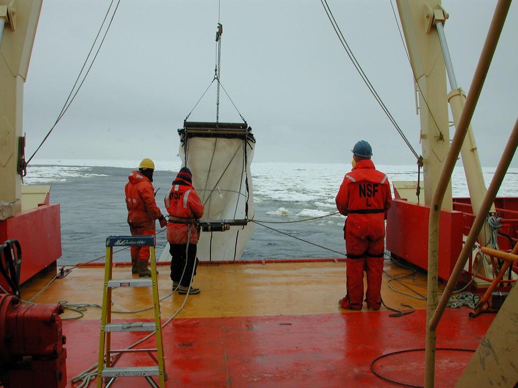
7 The Ocean Observatories Initiative (OOI): Instrumenting the Oceans
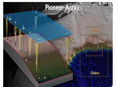
8 Long-term, in-situ instrumentation

9 Cyberinfrastructure: linking the marine infrastructure to science and user
10 OOI Challenges Vocabulary and Data Format OOI will have~50 instrument types The Instrument Operator on shore should not have to know how to task 50 different instruments; there needs to be a single set of basic commands (power on, take a reading, start autosampling, etc.) The heterogeneous data must flow into a common data model

11 OOI Challenges Vocabulary and Data Format Solution: write drivers and agents for each instrument class/model, and Data Processing algorithms for data ingestion Instrument Agent Driver Client OOI CI Instrument Driver Port Agent
12 Assessment OOI Challenges Vocabulary and Data Format Effective: instrument can be tasked and data ingested Scalable: new (different) instruments require new effort Interoperability: no gains outside of OOI
13 OOI Challenges Vocabulary and Data Format A better (partial) solution: Partner with instrument manufacturers to further develop and adopt a framework for describing sensor data provenance, building off of Open Geospatial Consortium SensorML, to allow standards-based, machine-harvestable encodings (Janet Fredericks, WHOI)


14 Rolling Deck to Repository (R2R) Managing underway data from research vessels
15
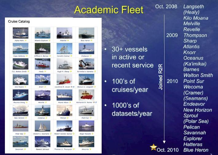
16 R2R Goals For the U.S. Academic Oceanographic Research Fleet: Migrate all routine underway data to long-term repositories Create catalog of cruises and standard products Assess data quality and provide timely feedback to vessels

17 R2R Challenges 1. Metadata Problem: R2R collects critical discovery and access metadata about a new level of granularity: a cruise
18 R2R Challenges 1. Metadata Solution: Work with the National Geophysical Data Center to create a new ISO compliant cruise-level metadata standard. (Text View) etc.
19 Assessment: R2R Challenges 1. Metadata Effective: substantial increase in discoverability and usability of data Scalable: after initial time investment, now auto-generated for new cruises Interoperability: builds off of existing generic ISO standard, creates new framework for others
20 R2R Challenges 2. Data Format Problem: large heterogeneity in formats for data coming from independent ship operators even when the same instrument is being used. Solution: parser for each data format variant; transformation to standard format for certain data types
21 R2R Challenges 2. Data Format Assessment Effective: allows data to be accessed Scalable: every new format requires same level of new effort. ~ Interoperability: approach creates no interoperability gains beyond reformatting done by R2R
22 R2R Challenges 2. Data Format A better solution: community adoption of format standards BUT for some data types, these already exist, and are simply not being used, mainly because of cost of initial change This needs a human/resource solution, not a technology solution

23 R2R Challenges, 3 Oceanographic Vessel Data are global and should be globally accessible. Emerging Ocean Data Interoperability Platform is addressing
24 R2R Challenges 3. Vocabulary Problem: similar concepts, such as countries, vessels, instruments, and datasets, are used by many oceanographic information systems.
25 R2R Challenges 3. Vocabulary Solution 1: Use existing controlled vocabularies where available Country (ISO) Cruise Type (UNOLS) Gazetteer - Exclusive Economic Zone (VLIZ) Gazetteer - Sea Area (IHO) Gazetteer - Undersea Feature Name (IHO) Language (ISO) Organization (IANA) Port (UNOLS) Processing Level (CODMAC) Sample Type (USGS) State (FIPS) Vessel (ICES)

26 R2R Challenges 3. Vocabulary Solution 2: R2R and partner organizations are adopting a linked data approach to make catalog content broadly and easily accessible. RDF & URIs SPARQL endpoints D2RQ DOIs
27 Assessment: Outside R2R Challenges Vocabulary? Effective: Too soon to assess use Scalable: Efficient re-use of vocabularies Interoperability: at vocabulary and Link level


28 A Question for Future Cross-Domain Interoperability To what degree should we mandate global standards or allow local domain-specific protocols? Some success in these projects with a global framework, and a local extension e.g. R2R Cruise metadata standard, from ISO Instrument self-reporting provenance, built on OGC SensorML Is this extensible? Are there better approaches?
Rolling Deck to Repository: Opportunities for US-EU Collaboration
 Rolling Deck to Repository: Opportunities for US-EU Collaboration Stephen Miller Scripps Institution of Oceanography La Jolla, California USA http://gdc.ucsd.edu Co-authors: Helen Glaves British Geological
Reducing Consumer Uncertainty
 Spatial Analytics Reducing Consumer Uncertainty Towards an Ontology for Geospatial User-centric Metadata Introduction Cooperative Research Centre for Spatial Information (CRCSI) in Australia Communicate
The Common Framework for Earth Observation Data. US Group on Earth Observations Data Management Working Group
 The Common Framework for Earth Observation Data US Group on Earth Observations Data Management Working Group Agenda USGEO and BEDI background Concise summary of recommended CFEOD standards today Full document
SEXTANT 1. Purpose of the Application
 SEXTANT 1. Purpose of the Application Sextant has been used in the domains of Earth Observation and Environment by presenting its browsing and visualization capabilities using a number of link geospatial
INSPIRE & Environment Data in the EU
 INSPIRE & Environment Data in the EU Andrea Perego Research Data infrastructures for Environmental related Societal Challenges Workshop @ pre-rda P6 Workshops, Paris 22 September 2015 INSPIRE in a nutshell
Jeffery S. Horsburgh. Utah Water Research Laboratory Utah State University
 Advancing a Services Oriented Architecture for Sharing Hydrologic Data Jeffery S. Horsburgh Utah Water Research Laboratory Utah State University D.G. Tarboton, D.R. Maidment, I. Zaslavsky, D.P. Ames, J.L.
Towards a pan-european infrastructure for marine and ocean data management + Importance of standards
 Towards a pan-european infrastructure for marine and ocean data management + Importance of standards By Dick M.A. Schaap MARIS Technical Coordinator SeaDataNet & ODIP Coordinator EMODnet Bathymetry Münster
Metadata for Data Discovery: The NERC Data Catalogue Service. Steve Donegan
 Metadata for Data Discovery: The NERC Data Catalogue Service Steve Donegan Introduction NERC, Science and Data Centres NERC Discovery Metadata The Data Catalogue Service NERC Data Services Case study:
How to use Water Data to Produce Knowledge: Data Sharing with the CUAHSI Water Data Center
 How to use Water Data to Produce Knowledge: Data Sharing with the CUAHSI Water Data Center Jon Pollak The Consortium of Universities for the Advancement of Hydrologic Science, Inc. (CUAHSI) August 20,
Leveraging metadata standards in ArcGIS to support Interoperability. David Danko and Aleta Vienneau
 Leveraging metadata standards in ArcGIS to support Interoperability David Danko and Aleta Vienneau Leveraging Metadata Standards in ArcGIS for Interoperability Why metadata and metadata standards? Overview
International Oceanographic Data and Information Exchange - Ocean Data Portal (IODE ODP)
") International Oceanographic Data and Information Exchange - Ocean Data Portal (IODE ODP) Enabling science through seamless and open access to marine data Credits This presentation was developed by: Mr.
International Oceanographic Data and Information Exchange - Ocean Data Portal (IODE ODP) Enabling science through seamless and open access to marine data Credits This presentation was developed by: Mr.
Reducing Consumer Uncertainty Towards a Vocabulary for User-centric Geospatial Metadata
 Meeting Host Supporting Partner Meeting Sponsors Reducing Consumer Uncertainty Towards a Vocabulary for User-centric Geospatial Metadata 105th OGC Technical Committee Palmerston North, New Zealand Dr.
Semantically enhancing SensorML with controlled vocabularies in the marine domain
 Semantically enhancing SensorML with controlled vocabularies in the marine domain KOKKINAKI ALEXANDRA, BUCK JUSTIN, DARROCH LOUISE, JIRKA SIMON AND THE MARINE PROFILES FOR OGC SENSOR WEB ENABLEMENT STANDARDS
Programming with the Semantic Web. Adam Shepherd C. Chandler, R. Arko, D. Fils, D. Kinkade, M. Jones
 Programming with the Semantic Web Adam Shepherd C. Chandler, R. Arko, D. Fils, D. Kinkade, M. Jones Oceanographic Cruise: Linking to Authoritative Source http://seft.com.tr/web/wp-content/uploads/2015/02/rsv66_01.png
The Ocean Observatories Initiative (OOI) UNOLS Fleet Improvement Committee Meeting Update
 UNOLS Fleet Improvement Committee Meeting Update") The Ocean Observatories Initiative (OOI) UNOLS Fleet Improvement Committee Meeting Update October 10, 2007 Susan Banahan Associate Director Status NSF/MREFC Capital Investment: $331M over five years Operation
The Ocean Observatories Initiative (OOI) UNOLS Fleet Improvement Committee Meeting Update October 10, 2007 Susan Banahan Associate Director Status NSF/MREFC Capital Investment: $331M over five years Operation
The European Commission s science and knowledge service. Joint Research Centre
 The European Commission s science and knowledge service Joint Research Centre GeoDCAT-AP The story so far Andrea Perego, Antonio Rotundo, Lieven Raes GeoDCAT-AP Webinar 6 June 2018 What is GeoDCAT-AP Geospatial
Motions from the 91st OGC Technical and Planning Committee Meetings Geneva, Switzerland Contents
 Motions from the 91st OGC Technical and Planning Committee Meetings Geneva, Switzerland Contents "The Open Geospatial Consortium and EarthCube White Paper... 2 Vote for OGC Sensor Observation Service 2.0
NSF Proposals and the Two Page Data Management Plan. 14 January 2011 Cyndy Chandler
 1 NSF Proposals and the Two Page Data Management Plan 14 January 2011 Cyndy Chandler 1 of 20 2 The Two Page Plan all NSF proposals (after January 17, 2011) must include a supplementary document of no more
GeoDCAT-AP Representing geographic metadata by using the "DCAT application profile for data portals in Europe"
 GeoDCAT-AP Representing geographic metadata by using the "DCAT application profile for data portals in Europe" Andrea Perego, Vlado Cetl, Anders Friis-Christensen, Michael Lutz, Lorena Hernandez Joint
Project title: Strengthening the cooperation between the US and the EU in the field of environmental research infrastructures
 Kick off meeting - REPORT Deliverable 4.2 Gap Analysis Report Grant Agreement number: 312118 Project acronym: COOPEUS Project title: Strengthening the cooperation between the US and the EU in the field
Introduction of SeaDataNet and EMODNET Working towards a harmonised data infrastructure for marine data. Peter Thijsse MARIS
 Introduction of SeaDataNet and EMODNET Working towards a harmonised data infrastructure for marine data Peter Thijsse MARIS CLIPC & IS-ENES 2 workshop, KNMI, November 2014 Outline 1. Introduction to marine
Multi-Community, Multi-Sensor Maritime Earth Observation DC
 Multi-Community, Multi-Sensor Maritime Earth Observation DC How do you eat the elephant? Gianluca Luraschi EO Project Manager and Application Architect Gianluca.luraschi@emsa.europa.eu SafeSeaNet Ecosystem
European Marine Data Exchange
 European Marine Data Exchange By Dick M.A. Schaap MARIS (NL) EU SeaDataNet Technical Coordinator EU EMODnet Ingestion Coordinator Noordzeedagen 2018 - October 2018 Acquisition of ocean and marine data
EarthCube and Cyberinfrastructure for the Earth Sciences: Lessons and Perspective from OpenTopography
 EarthCube and Cyberinfrastructure for the Earth Sciences: Lessons and Perspective from OpenTopography Christopher Crosby, San Diego Supercomputer Center J Ramon Arrowsmith, Arizona State University Chaitan
Data discovery and access via the SeaDataNet CDI system
 Data discovery and access via the SeaDataNet CDI system Central dataproducts and data services on distributed data. Peter Thijsse MARIS CLIPC IS-ENES workshop, KNMI, November 2014 Outline 1. Introduction
Deliverable 6.4. Initial Data Management Plan. RINGO (GA no ) PUBLIC; R. Readiness of ICOS for Necessities of integrated Global Observations
 PUBLIC; R. Readiness of ICOS for Necessities of integrated Global Observations") Ref. Ares(2017)3291958-30/06/2017 Readiness of ICOS for Necessities of integrated Global Observations Deliverable 6.4 Initial Data Management Plan RINGO (GA no 730944) PUBLIC; R RINGO D6.5, Initial Risk
Ref. Ares(2017)3291958-30/06/2017 Readiness of ICOS for Necessities of integrated Global Observations Deliverable 6.4 Initial Data Management Plan RINGO (GA no 730944) PUBLIC; R RINGO D6.5, Initial Risk
Linking datasets with user commentary, annotations and publications: the CHARMe project
 Linking datasets with user commentary, annotations and publications: the CHARMe project Jon Blower j.d.blower@reading.ac.uk University of Reading On behalf of all CHARMe partners! http://www.charme.org.uk
Sensor Data Management
 Wright State University CORE Scholar Kno.e.sis Publications The Ohio Center of Excellence in Knowledge- Enabled Computing (Kno.e.sis) 8-14-2007 Sensor Data Management Cory Andrew Henson Wright State University
INSPIRE Download Service
 The OGC SOS as INSPIRE Download Service for (meteorological) l) Observation Data Simon Jirka (52 North) 29 th October 2014 5th Workshop on the use of GIS/OGC standards in meteorology Offenbach (Germany)
Data Exchange in the Earth Sciences
 Data Exchange in the Earth Sciences Perspective of a multidisciplinary data facility Kerstin Lehnert, Columbia University lehnert@ldeo.columbia.edu 1 Access to Data Transparency & Reproducibility Publishers/Journals
Navigating Getty Provenance Resources & Datasets 2016 Pacific Neighborhood Consortium Annual Conference
 Navigating Getty Provenance Resources & Datasets 2016 Pacific Neighborhood Consortium Annual Conference Melissa Gill Digital Projects Manager Getty Research Institute Sally McKay Head of Special Collections
The New Electronic Chart Product Specification S-101: An Overview
 The New Electronic Chart Product Specification S-101: An Overview Julia Powell Marine Chart Division, Office of Coast Survey, NOAA 1315 East West Hwy, Silver Spring, MD 20715 Julia.Powell@noaa.gov 301-713-0388
Putting Your Data on the Map
 Putting Your Data on the Map Cyndy Chandler WHOI Marine Chemistry Department Woods Hole Data Mongers / Ocean Informatics Meeting 4 April 2007 - WHOI Finding the OI in WHOI What is Ocean Informatics? The
Towards a pan-european infrastructure for marine and ocean data management + Importance of standards
 Towards a pan-european infrastructure for marine and ocean data management + Importance of standards By Dick M.A. Schaap Technical Coordinator SeaDataNet & Coordinator EMODnet Bathymetry Hydrography Day,
Proof-of-Concept Evaluation for Modelling Time and Space. Zaenal Akbar
 Proof-of-Concept Evaluation for Modelling Time and Space (PlanetData Deliverable 2.5) Zaenal Akbar December 14, 2015 Copyright 2015 STI INNSBRUCK www.sti-innsbruck.at Outline Introduction Product: Map4RDF-iOS
SAFER the GIGAS Effect
 SAFER the GIGAS Effect How INSPIRE, GMES and GEOSS are influencing EC projects Arnaud Cauchy 23/06/2010 Agenda GIGAS Project Summary SAFER Project Summary SAFER Original Approach GIGAS Influences SAFER
Leveraging metadata standards in ArcGIS to support Interoperability. Aleta Vienneau and Marten Hogeweg
 Leveraging metadata standards in ArcGIS to support Interoperability Aleta Vienneau and Marten Hogeweg Leveraging metadata standards in ArcGIS to support Interoperability Overview of metadata standards
Observation trends: Expectations from European Comission regarding data exchange and interoperability
 Observation trends: Expectations from European Comission regarding data exchange and interoperability Marcin Wichorowski (IO PAN), Sławomir Sagan (IO PAN), Declan Dunne (UCC MaREI), John Barton (UCC-TYNDALL)
EUDAT B2FIND A Cross-Discipline Metadata Service and Discovery Portal
 EUDAT B2FIND A Cross-Discipline Metadata Service and Discovery Portal Heinrich Widmann, DKRZ DI4R 2016, Krakow, 28 September 2016 www.eudat.eu EUDAT receives funding from the European Union's Horizon 2020
/// INTEROPERABILITY BETWEEN METADATA STANDARDS: A REFERENCE IMPLEMENTATION FOR METADATA CATALOGUES
 /// Position Paper /// INTEROPERABILITY BETWEEN METADATA STANDARDS: A REFERENCE IMPLEMENTATION FOR METADATA CATALOGUES /// Keywords: Public administration, Metadata, Geographical Information, Geospatial
ISA Action 1.17: A Reusable INSPIRE Reference Platform (ARE3NA)
") ISA Action 1.17: A Reusable INSPIRE Reference Platform (ARE3NA) Expert contract supporting the Study on RDF and PIDs for INSPIRE Deliverable D.EC.3.2 RDF in INSPIRE Open issues, tools, and implications
ISA Action 1.17: A Reusable INSPIRE Reference Platform (ARE3NA) Expert contract supporting the Study on RDF and PIDs for INSPIRE Deliverable D.EC.3.2 RDF in INSPIRE Open issues, tools, and implications
OOI CyberInfrastructure Conceptual and Deployment Architecture
 OOI Cyber Conceptual and Deployment Architecture CI Overview Goals and Objectives From Requirements to Architecture OOI-CI Services Architectural Pattern Logical Architecture Domain Models Example Deployment
EMODnet Bathymetry. By Dick M.A. Schaap Coordinator. 20 th April 2016, EGU 2016, Vienna - Austria
 EMODnet Bathymetry By Dick M.A. Schaap Coordinator 20 th April 2016, EGU 2016, Vienna - Austria EMODNet Bathymetry Ongoing in 3 consecutive projects since 2009 with expanding consortium (at present >30
Long-term preservation for INSPIRE: a metadata framework and geo-portal implementation
 Long-term preservation for INSPIRE: a metadata framework and geo-portal implementation INSPIRE 2010, KRAKOW Dr. Arif Shaon, Dr. Andrew Woolf (e-science, Science and Technology Facilities Council, UK) 3
SeaDataNet, Pan-European infrastructure for marine and ocean data management + EMODNET Bathymetry
 SeaDataNet, Pan-European infrastructure for marine and ocean data management + EMODNET Bathymetry By Dick M.A. Schaap Technical Coordinator SeaDataNet & Coordinator EMODNet Bathymetry Limassol Cyprus,
GEOSS Data Management Principles: Importance and Implementation
 GEOSS Data Management Principles: Importance and Implementation Alex de Sherbinin / Associate Director / CIESIN, Columbia University Gregory Giuliani / Lecturer / University of Geneva Joan Maso / Researcher
Building Virtual Earth Observatories Using Scientific Database, Semantic Web and Linked Geospatial Data Technologies
 Building Virtual Earth Observatories Using Scientific Database, Semantic Web and Linked Geospatial Data Technologies Presenter: George Garbis ggarbis@di.uoa.gr Dept. of Informatics and Telecommunications
SeaDataNet, Pan-European infrastructure for marine ands ocean data management + EMODNET Preparatory Action Hydrographic and Seabed Mapping
 SeaDataNet, Pan-European infrastructure for marine ands ocean data management + EMODNET Preparatory Action Hydrographic and Seabed Mapping By Dick M.A. Schaap Technical Coordinator SeaDataNet & Coordinator
Geo Seas A pan European infrastructure for the management of marine geological and geophysical data
 Geo Seas A pan European infrastructure for the management of marine geological and geophysical data Colin Graham (BGS), Dick Schaap (MARIS), Paolo Diviacco (OGS) & Helen Glaves (BGS) Integrated Infrastructure
Paving the Rocky Road Toward Open and FAIR in the Field Sciences
 Paving the Rocky Road Toward Open and FAIR Kerstin Lehnert Lamont-Doherty Earth Observatory, Columbia University IEDA (Interdisciplinary Earth Data Alliance), www.iedadata.org IGSN e.v., www.igsn.org Field
Links, languages and semantics: linked data approaches in The European Library and Europeana. Valentine Charles, Nuno Freire & Antoine Isaac
 Links, languages and semantics: linked data approaches in The European Library and Europeana. Valentine Charles, Nuno Freire & Antoine Isaac 14 th August 2014, IFLA2014 satellite meeting, Paris The European
eresearch Collaboration across the Pacific:
 eresearch Collaboration across the Pacific: Marine Systems and Australian Marine Science Craig Johnson University of Tasmania Outline Introduce the Australian Ocean Network Possibilities for trans-pacific
DataONE: Open Persistent Access to Earth Observational Data
 Open Persistent Access to al Robert J. Sandusky, UIC University of Illinois at Chicago The Net Partners Update: ONE and the Conservancy December 14, 2009 Outline NSF s Net Program ONE Introduction Motivating
CMSP Discovery Vocabularies Workshop. A Joint WHOI/USGS/NOAA Workshop
 CMSP Discovery Vocabularies Workshop A Joint WHOI/USGS/NOAA Workshop Agenda Wed. Dec. 1 12:00 Opening Lunch 1:00 Introductions and Review of Meeting: Andy Maffei, WHOI 1:30 Overview of the National Ocean
Technical documentation. SIOS Data Management Plan
 Technical documentation SIOS Data Management Plan SIOS Data Management Plan Page: 2/10 SIOS Data Management Plan Page: 3/10 Versions Version Date Comment Responsible 0.3 2017 04 19 Minor modifications
(Geo)DCAT-AP Status, Usage, Implementation Guidelines, Extensions
DCAT-AP Status, Usage, Implementation Guidelines, Extensions") (Geo)DCAT-AP Status, Usage, Implementation Guidelines, Extensions HMA-AWG Meeting ESRIN (Room D) 20. May 2016 Uwe Voges (con terra GmbH) GeoDCAT-AP European Data Portal European Data Portal (EDP): central
(Geo)DCAT-AP Status, Usage, Implementation Guidelines, Extensions HMA-AWG Meeting ESRIN (Room D) 20. May 2016 Uwe Voges (con terra GmbH) GeoDCAT-AP European Data Portal European Data Portal (EDP): central
Introduction to INSPIRE. Network Services
 Introduction to INSPIRE. Network Services European Commission Joint Research Centre Institute for Environment and Sustainability Digital Earth and Reference Data Unit www.jrc.ec.europa.eu Serving society
PUBLICATION OF INSPIRE-BASED AGRICULTURAL LINKED DATA
 This project has received funding from the European Union s Horizon 2020 research and innovation programme under grant agreement No 732064 This project is part of BDV PPP PUBLICATION OF INSPIRE-BASED AGRICULTURAL
The Butterfly Effect. A proposal for distribution and management for butterfly data programs. Dave Waetjen SESYNC Butterfly Workshop May 10, 2012
 The Butterfly Effect A proposal for distribution and management for butterfly data programs Dave Waetjen SESYNC Butterfly Workshop May 10, 2012 http://butterfly.ucdavis.edu Citizen Science based Observation
Enrichment of Sensor Descriptions and Measurements Using Semantic Technologies. Student: Alexandra Moraru Mentor: Prof. Dr.
 Enrichment of Sensor Descriptions and Measurements Using Semantic Technologies Student: Alexandra Moraru Mentor: Prof. Dr. Dunja Mladenić Environmental Monitoring automation Traffic Monitoring integration
Contribution of OCLC, LC and IFLA
 Contribution of OCLC, LC and IFLA in The Structuring of Bibliographic Data and Authorities : A path to Linked Data BY Basma Chebani Head of Cataloging and Metadata Services, AUB Libraries Presented to
Global Cryosphere Watch. GCW web portal Structure and demonstration
 Global Cryosphere Watch GCW web portal Structure and demonstration Øystein Godøy The high level purpose The GCW web portal will make GCW data and information available to WMO Members, their partners, and
Italy - Information Day: 2012 FP7 Space WP and 5th Call. Peter Breger Space Research and Development Unit
 Italy - Information Day: 2012 FP7 Space WP and 5th Call Peter Breger Space Research and Development Unit Content Overview General features Activity 9.1 Space based applications and GMES Activity 9.2 Strengthening
DSpace Fedora. Eprints Greenstone. Handle System
 Enabling Inter-repository repository Access Management between irods and Fedora Bing Zhu, Uni. of California: San Diego Richard Marciano Reagan Moore University of North Carolina at Chapel Hill May 18,
Observatory Middleware Framework (OMF)
") Observatory Middleware Framework (OMF) Duane R. Edgington 1, Randal Butler 2, Terry Fleury 2, Kevin Gomes 1, John Graybeal 1, Robert Herlien 1, Von Welch 2 1 Monterey Bay Aquarium Research Institute, 7700
Observatory Middleware Framework (OMF) Duane R. Edgington 1, Randal Butler 2, Terry Fleury 2, Kevin Gomes 1, John Graybeal 1, Robert Herlien 1, Von Welch 2 1 Monterey Bay Aquarium Research Institute, 7700
The GeoPortal Cookbook Tutorial
 The GeoPortal Cookbook Tutorial Wim Hugo SAEON/ SAEOS SCOPE OF DISCUSSION Background and Additional Resources Context and Concepts The Main Components of a GeoPortal Architecture Implementation Options
Understanding and Using Metadata in ArcGIS. Adam Martin Marten Hogeweg Aleta Vienneau
 Understanding and Using Metadata in ArcGIS Adam Martin Marten Hogeweg Aleta Vienneau Adam Martin National Government Account Management R&D Open Data Marten Hogeweg National Government Professional Services
PRELIMINARY INTERFACE REQUIREMENTS AGREEMENT
 PRELIMINARY INTERFACE REQUIREMENTS AGREEMENT November 2007 DRAFT v2.3 Consortium for Ocean Leadership 1201 New York Avenue NW, Fourth Floor, Washington, D.C. 20005 www.joiscience.org Table of Contents
Supporting Data Stewardship Throughout the Data Life Cycle in the Solid Earth Sciences
 Supporting Data Stewardship Throughout the Data Life Cycle in the Solid Earth Sciences Vicki L. Ferrini, Kerstin A. Lehnert, Suzanne M. Carbotte, and Leslie Hsu Lamont-Doherty Earth Observatory What is
Novel System Architectures for Semantic Based Sensor Networks Integraion
 Novel System Architectures for Semantic Based Sensor Networks Integraion Z O R A N B A B O V I C, Z B A B O V I C @ E T F. R S V E L J K O M I L U T N O V I C, V M @ E T F. R S T H E S C H O O L O F T
Open Geospatial Consortium
 Open Geospatial Consortium Date: 2011-07-12 Reference number of this document: OGC 11-013r6 Category: Engineering Report Editors: Luis Bermudez, David Arctur OGC Engineering Report: Water Information Services
Developing a Free and Open Source Software based Spatial Data Infrastructure. Jeroen Ticheler
 Developing a Free and Open Source Software based Spatial Data Infrastructure Jeroen Ticheler 1 License This work is licensed under the Creative Commons Attribution-NonCommercial-ShareAlike 2.5 License.
Extension of INSPIRE Download Services TG for Observation Data
 Extension of INSPIRE Download Services TG for Observation Data Simon Jirka (52 North) 14 th June 2014, MIG Workshop on WCS-based INSPIRE Download Services Agenda Motivation Sensor Web Proposed Update for
INSPIRE overview and possible applications for IED and E-PRTR e- Reporting Alexander Kotsev
 INSPIRE overview and possible applications for IED and E-PRTR e- Reporting Alexander Kotsev www.jrc.ec.europa.eu Serving society Stimulating innovation Supporting legislation The European data puzzle 24
Interoperability ~ An Introduction
 Interoperability ~ An Introduction Cyndy Chandler Biological and Chemical Oceanography Data Management Office (BCO-DMO) Woods Hole Oceanographic Institution 26 July 2008 MMI OOS Interoperability Planning
Cheshire 3 Framework White Paper: Implementing Support for Digital Repositories in a Data Grid Environment
 Cheshire 3 Framework White Paper: Implementing Support for Digital Repositories in a Data Grid Environment Paul Watry Univ. of Liverpool, NaCTeM pwatry@liverpool.ac.uk Ray Larson Univ. of California, Berkeley
INSPIRE: The ESRI Vision. Tina Hahn, GIS Consultant, ESRI(UK) Miguel Paredes, GIS Consultant, ESRI(UK)
 Miguel Paredes, GIS Consultant, ESRI(UK)") INSPIRE: The ESRI Vision Tina Hahn, GIS Consultant, ESRI(UK) Miguel Paredes, GIS Consultant, ESRI(UK) Overview Who are we? Introduction to ESRI Inc. and ESRI(UK) Presenters ArcGIS The ESRI Solution to
INSPIRE: The ESRI Vision Tina Hahn, GIS Consultant, ESRI(UK) Miguel Paredes, GIS Consultant, ESRI(UK) Overview Who are we? Introduction to ESRI Inc. and ESRI(UK) Presenters ArcGIS The ESRI Solution to
When using this architecture for accessing distributed services, however, query broker and/or caches are recommendable for performance reasons.
 Integration of semantics, data and geospatial information for LTER Abstract The long term ecological monitoring and research network (LTER) in Europe[1] provides a vast amount of data with regard to drivers
MAJOR RESEARCH EQUIPMENT $240,450,000 AND FACILITIES CONSTRUCTION
 MAJOR RESEARCH EQUIPMENT $240,450,000 AND FACILITIES CONSTRUCTION The FY 2007 Budget Request for the Major Research Equipment and Facilities Construction (MREFC) account is $240.45 million, an increase
The Many Facets of THREDDS Thematic Real-time Environmental Distributed Data Services
 The Many Facets of THREDDS Thematic Real-time Environmental Distributed Data Services For March 2007 Unidata Policy Committee Meeting Ben Domenico 1 Motivation From the Unidata 2003 proposal: utilizing
Big, Linked and Open Earth Observation Data: the Projects TELEIOS and LEO
 Big, Linked and Open Earth Observation Data: the Projects TELEIOS and LEO Manolis Koubarakis Charalampos Nikolaou HELLENIC REPUBLIC National and Kapodistrian University of Athens Introduction TELEIOS:
Introduction to Prod-Trees
 European Geosciences Union General Assembly 2014 Prod Trees Bernard Valentin Vienna Austria 29 April 2014 Outline 2 Background Prod-Trees Project RARE Project and Platform Status Future Background (ESA)
Semantic Web: Core Concepts and Mechanisms. MMI ORR Ontology Registry and Repository
 Semantic Web: Core Concepts and Mechanisms MMI ORR Ontology Registry and Repository Carlos A. Rueda Monterey Bay Aquarium Research Institute Moss Landing, CA ESIP 2016 Summer meeting What s all this about?!
Roy Lowry, Gwen Moncoiffe and Adam Leadbetter (BODC) Cathy Norton and Lisa Raymond (MBLWHOI Library) Ed Urban (SCOR) Peter Pissierssens (IODE Project
 Cathy Norton and Lisa Raymond (MBLWHOI Library) Ed Urban (SCOR) Peter Pissierssens (IODE Project") Roy Lowry, Gwen Moncoiffe and Adam Leadbetter (BODC) Cathy Norton and Lisa Raymond (MBLWHOI Library) Ed Urban (SCOR) Peter Pissierssens (IODE Project Office) Linda Pikula (IODE GEMIM/NOAA Library) Data
Roy Lowry, Gwen Moncoiffe and Adam Leadbetter (BODC) Cathy Norton and Lisa Raymond (MBLWHOI Library) Ed Urban (SCOR) Peter Pissierssens (IODE Project Office) Linda Pikula (IODE GEMIM/NOAA Library) Data
Europeana update: aspects of the data
 Europeana update: aspects of the data Robina Clayphan, Europeana Foundation European Film Gateway Workshop, 30 May 2011, Frankfurt/Main Overview The Europeana Data Model (EDM) Data enrichment activity
Core Technology Development Team Meeting
 Core Technology Development Team Meeting To hear the meeting, you must call in Toll-free phone number: 1-866-740-1260 Access Code: 2201876 For international call in numbers, please visit: https://www.readytalk.com/account-administration/international-numbers
THE ENVIRONMENTAL OBSERVATION WEB AND ITS SERVICE APPLICATIONS WITHIN THE FUTURE INTERNET Project introduction and technical foundations (I)
") ENVIROfying the Future Internet THE ENVIRONMENTAL OBSERVATION WEB AND ITS SERVICE APPLICATIONS WITHIN THE FUTURE INTERNET Project introduction and technical foundations (I) INSPIRE Conference Firenze,
ENVIROfying the Future Internet THE ENVIRONMENTAL OBSERVATION WEB AND ITS SERVICE APPLICATIONS WITHIN THE FUTURE INTERNET Project introduction and technical foundations (I) INSPIRE Conference Firenze,
Chain of Command. Chief of Naval Operations. Commander, U.S. Fleet Forces Command. COMNAVMETOCCOM (CNMOC) Stennis Space Center, MS
 Stennis Space Center, MS") 1 Chain of Command Chief of Naval Operations Commander, U.S. Fleet Forces Command Fleet Numerical Meteorology And Oceanography Center (FNMOC) Monterey, CA Naval Oceanographic Office (NAVOCEANO) Stennis
1 Chain of Command Chief of Naval Operations Commander, U.S. Fleet Forces Command Fleet Numerical Meteorology And Oceanography Center (FNMOC) Monterey, CA Naval Oceanographic Office (NAVOCEANO) Stennis
Multi-disciplinary Interoperability: the EuroGEOSS Operating Capacities
 Multi-disciplinary Interoperability: the EuroGEOSS Operating Capacities Stefano Nativi (CNR) stefano.nativi@cnr.it Opening and context for Global Dimension Stream: EuroGEOSS contribution to the Global
INSPIRE & Linked Data: Bridging the Gap Part II: Tools for linked INSPIRE data
 Making the Web an Exploratory Place for Geospatial Knowledge INSPIRE & Linked Data: Bridging the Gap Part II: Tools for linked INSPIRE data Michalis Alexakis Spiros Athanasiou Nikos Georgomanolis Giorgos
Tool for Mapping Tabular Data to an Ontology, A Work-In-Progress
 Tool for Mapping Tabular Data to an Ontology, A Work-In-Progress 2 Jun 2014 Andrea Westerinen andreaw@ninepts.com Agenda Problem Approach Background, iringtools Templates Mapping infrastructure Working
Semantic Infrastructure and Platforms for Geospatial Services: A report from European Projects 4 th International Workshop on Semantic and
 Semantic Infrastructure and Platforms for Geospatial Services: A report from European Projects 4 th International Workshop on Semantic and Conceptual Issues in GIS (SeCoGIS 2010) Vancouver, Canada November
How FAIR am I? FAIR Principles and Interoperability of Data and Tools
 How FAIR am I? FAIR Principles and Interoperability of Data and Tools Peter Doorn, DANS @pkdoorn @dansknaw Plan-Europe - Platform of National escience Centers in Europe PLAN-E meeting, April 27 & 28, 2017,
Interoperability Between GRDC's Data Holding And The GEOSS Infrastructure
 City University of New York (CUNY) CUNY Academic Works International Conference on Hydroinformatics 8-1-2014 Interoperability Between GRDC's Data Holding And The GEOSS Infrastructure Volker Andres Henning
IMPROVING THE INFRASTRUCTURE FOR EARTH OBSERVATION, ACTIONS AND UPDATES FROM THE SENTINEL ALPINE OBSERVATORY AT EURAC RESEARCH
 IMPROVING THE INFRASTRUCTURE FOR EARTH OBSERVATION, ACTIONS AND UPDATES FROM THE SENTINEL ALPINE OBSERVATORY AT EURAC RESEARCH Jacob, A., Marin, C., Monsorno, R., Ventura, B., Vianello, A., Costa, A.,
Extending SOA Infrastructure for Semantic Interoperability
 Extending SOA Infrastructure for Semantic Interoperability Wen Zhu wzhu@alionscience.com ITEA System of Systems Conference 26 Jan 2006 www.alionscience.com/semantic Agenda Background Semantic Mediation
Metadata of geographic information
 Metadata of geographic information Kai Koistinen Management of environmental data and information 4.10.2017 Topics Metadata of geographic information What is metadata? Metadata standards and recommendations
Using the OGC SOS as INSPIRE Download Service for Observation Data
 Using the OGC SOS as INSPIRE Download Service for Observation Data Simon Jirka (52 North) Alexander Kotsev (JRC) Michael Lutz (JRC) Matthes Rieke (52 North) Robin Smith (JRC) Paul Smits (JRC) 18 th June
ORION/OOI CYBERINFRASTRUCTURE
 ORION/OOI CYBERINFRASTRUCTURE Cyberinfrastructure Cyberinfrastructure: : the coordinated aggregate of software, hardware and other technologies, as well as human expertise, required to support current
Webservice-energy.org GEO Community Portal & Spatial Data Infrastructure for Energy
 Webservice-energy.org GEO Community Portal & Spatial Data Infrastructure for Energy Lionel Menard / Oct. 23 2017 Centre Observation, Impacts, Energy Research activities: Use of Earth observation data (Models,