IndianaMap Release 3. Rick Hill, Paul Rohwer,, Chris Dintaman, Becky Meyer, and Denver Harper
|
|
|
- Philip Reed
- 6 years ago
- Views:
Transcription
1 IndianaMap Release 3 Rick Hill, Paul Rohwer,, Chris Dintaman, Becky Meyer, and Denver Harper

2 IndianaMap
3 Agenda Session 1 & 2 Overview Tentative rollout schedule Old versus New Design and construction of IndianaMap R3 ArcGIS Server Silverlight User interface Definition of terms Layer Gallery Basemap Gallery Map Gallery Thematic maps Advanced features REST Services Caching User support Session 3 Roundtable discussion Establishing new partnerships Submitting data for inclusion on IndianaMa Requesting new thematic maps Feedback
4 Overview IndianaMap R3 Features User Customized Maps Layer Gallery Map Gallery Basemap Gallery REST Map Services Cached Layers Improved Performance Updated Tools
5 Overview R2 R3 Printing Bookmarks Drawing Layer Gallery Map Gallery Basemap Gallery REST services Add External Data
6 Overview Rollout Schedule IndianaMap R3 development began in Fall IndianaMap R3 Beta testing will begin this Spring. IGIC members will be invited to be Beta testers. IndianaMap R3 Release is scheduled for the summer of IndianaMap R3 Road Shows and Webinars Demonstration and training sessions will be scheduled shortly after formal release.
7 Agenda Session 1 & 2 Overview Tentative rollout schedule Old versus New Design and construction of IndianaMap R3 ArcGIS Server Silverlight User interface Definition of terms Layer Gallery Basemap Gallery Map Gallery Thematic maps Advanced features REST Services Caching User support Session 3 Roundtable discussion Establishing new partnerships Submitting data for inclusion on IndianaMa Requesting new thematic maps Feedback
8 Design and construction ArcGIS Server 10.X Why ArcGIS Server? Contracted by Indiana Office of Technology (IOT) ArcIMS 10 does not publish MXD s Allows more flexible organization of datasets Widely disseminate access to the public Is it faster? Is it more stable?

9 Design and construction Performance Optimized map service average response time: 0.69 seconds ArcIMS map service average response time: 0.83 seconds Standard map service average response time: 2.21 seconds From ESRI White Paper, August 2009
10 Design and construction Silverlight Silverlight versus Adobe Flex or Javascript Why Silverlight? Long term sustainability Rich internet application Client side plug in handles many tasks previously performed on the server Improves responsiveness

11 User interface Ribbon toolbar

12 User interface Map Center

13 User interface Sidebar

14 User interface Measure tool

15 User interface Identify tool
16 Agenda Session 1 & 2 Overview Tentative rollout schedule Old versus New Design and construction of IndianaMap R3 ArcGIS Server Silverlight User interface Definition of terms Layer Gallery Basemap Gallery Map Gallery Thematic maps Advanced features REST Services Caching User support Session 3 Roundtable discussion Establishing new partnerships Submitting data for inclusion on IndianaMa Requesting new thematic maps Feedback
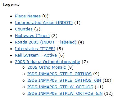
17 Definition of terms Layer Gallery Description Organizes 240 layers with thumbnails and summary descriptions Find layers by category or by keyword search Preview and select layers to be added to the IndianaMap Viewer Download shapefiles, and view metadata

18 Layer gallery

19 Layer gallery Preview and Details

20 Layer gallery Preview Maps
21 Layer gallery Details

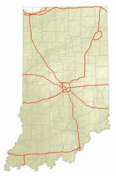
22 Definition of terms Basemap Gallery Definition Basemaps are predesigned maps that serve as the background for a custom map. Role or function Each basemap is made from multiple layers fused into a cached service Makes construction of custom maps faster and easier Types that will be available on IndianaMap Aerial photos Topographic maps Hillshaded relief Public Land Survey System More to come

23 Imagery Basemap

24 Basemap Imagery Hybrid

25 Basemap Shaded Relief

26 Topos Basemap

27 NAIP 2010 Basemap
28 Basemap Public Land Survey System in preparation More to come Suggestions from users
29 Definition of terms Definition A collection of thematic maps. Map Gallery Thematic maps are a prebundled collection of related layers that can be superimposed on a basemap. Function Speeds up the production of a custom map. Examples Watershed Coordinators Thematic Map Public Safety Thematic Map

30 Map gallery Thematic Maps


31 Map gallery Thematic Maps Watershed Coordinators
32 Map gallery We are open to suggestions from users to build and host thematic maps. Recreation thematic map Alternative energy thematic map Selected demographic maps Economic development maps Natural resources maps Environment maps
33 Agenda Session 1 & 2 Overview Tentative rollout schedule Old versus New Design and construction of IndianaMap R3 ArcGIS Server Silverlight User interface Definition of terms Layer Gallery Basemap Gallery Map Gallery Thematic maps Advanced features REST Services Caching User support Session 3 Roundtable discussion Establishing new partnerships Submitting data for inclusion on IndianaMa Requesting new thematic maps Feedback
34 Advanced features REST Services (Representational State Transfer) Definition A unique URL for a GIS map service published with ArcGIS Server. It can be used to serve a single GIS layer, or a collection of layers. Role or function Give users access to the GIS layer or layers in a custom map viewer (e.g., IndianaMap or Google Earth) or in desktop GIS software (e.g., ArcMap) Types of REST Services that will be offered by IndianaMap WMS desktop GIS software, open source online map viewers KML for Google Earth and supporting open source platforms


35 Advanced features REST services Organization and naming convention
36 Advanced features REST services Expanded view options

37 View Options ArcGIS.com Advanced features REST services

38 View Options ArcMap Advanced features REST services

39 Advanced features REST services View Options ArcGIS Explorer Online
40 Advanced features REST services View Options Google Earth
41 Advanced features REST services Service Metadata
42 Advanced features REST services Layer Metadata
43 Advanced features REST services Supported Interfaces
44 Advanced features REST services Supported Operations

45 Advanced features REST services Supported Operations Identify
46 Advanced features REST services Supported Operations Layer Query

47 Advanced features REST services Supported Operations Generate KML
48 Advanced features REST services Supported Operations Custom ArcGIS Server supports custom operations, such as geoprocessing tasks and customized queries (such as find parcel ID or custom calculations) What geoprocessing tasks would you find useful?

49 Advanced features REST services Add Basemap to ArcGIS Explorer Online

50 Advanced features REST services Example of IGS REST Services
 is pre drawn as tiles of imagery at predefined levels of detail")

51 Advanced features Caching Caching Definition Each layer (including basemaps) is pre drawn as tiles of imagery at predefined levels of detail and spatial reference Caching on IndianaMap Spatial reference: UTM, Zone 16, NAD83 Scales: Thirteen levels ranging from 1:2,500,000 to 1:500 1:500,000 1:250,000

52 Advanced features Caching Dramatic responsiveness Better server usage Improved scalability Function Cached Map Service Dynamic Map Service 1.5 seconds 4.0 seconds

53 Advanced features Caching Performance From ESRI White Paper, August 2009 Caching retains high performance, even with a large number of users

54 Advanced features Caching Task Related Performance From ESRI White Paper, August 2009 Even with caching, the performance of certain tasks degrades with more users
55 Advanced features Caching Caching IndianaMap We have chosen compact cache Bundled file format Each bundle contains 16,000 tiles Given 30M tiles per layer, then there are 1,875 bundles 240 layers = 7.2B tiles = 450M bundles Spatial reference: UTM, Zone 16, NAD83 Scales: Thirteen levels ranging from 1:2,500,000 to 1:500 Tile size: 512 x 512 pixels
56 Advanced features Caching The Challenges of Caching IndianaMap The problem Caching more than 240 layers Time required = 3 days per layer More than 2 years would be required to complete caching on a single machine The solution Cloud computing Partnering with University Information Technology Services (UITS) of I.U. High performance computing, utilizing multiple ArcGIS servers Only about 2 months will be required to cache more than 240 layers

57 Advanced features Caching The Challenges of Caching IndianaMap Size and number of tiles: Exploded versus compact ~ 30 GB per cached layer Basemaps and imagery are considerably larger ~ 300 GB

58 Advanced features Caching Caching and spatial references Web Mercator versus UTM
59 Advanced features summary The advanced features: can be used in many different applications and viewers underpins the functionality of IndianaMap Viewer (R3) makes the IndianaMap Viewer (R3) easier for users to build custom maps You need a runway before you take off ~Anonymous
60 Agenda Session 1 & 2 Overview Tentative rollout schedule Old versus New Design and construction of IndianaMap R3 ArcGIS Server Silverlight User interface Definition of terms Layer Gallery Basemap Gallery Map Gallery Thematic maps Advanced features REST Services Caching User support Session 3 Roundtable discussion Establishing new partnerships Submitting data for inclusion on IndianaMa Requesting new thematic maps Feedback


61 Narrated video tutorials Road shows and Webinars support IT notices Twitter Listserv notices User support

62 Aloha
63 Agenda Session 1 & 2 Overview Tentative rollout schedule Old versus New Design and construction of IndianaMap R3 ArcGIS Server Silverlight User interface Definition of terms Layer Gallery Basemap Gallery Map Gallery Thematic maps Advanced features REST Services Caching User support Session 3 Roundtable discussion Establishing new partnerships Submitting data for inclusion on IndianaMa Requesting new thematic maps Feedback
64 IndianaMap Release 3 Roundtable Discussion Questions, comments and discussion
What s New in ArcGIS Server 10
 What s New in ArcGIS Server 10 Derek Law ArcGIS Server Product Management What s s new in ArcGIS Server 10? Agenda Highlights: Enhanced Web mapping More powerful server-based analysis Geo-collaboration
Designing and Using Basemaps. Jennifer Hughey
 Designing and Using Basemaps Jennifer Hughey Agenda The ArcGIS System Basemaps are a key component of your system Cartographic design considerations Using basemap layers in ArcMap Best practices for designing
ESRI Technology Update. Joe Holubar Larry Young
 ESRI Technology Update Joe Holubar Larry Young Continued Improvement Improving Quality and Extending and Refining Functionality First Half of 2009: Minor Update Release (ArcGIS 9.3.1) ArcGIS Explorer Fall
Getting Started with ArcGIS for Server. Charmel Menzel and Ken Gorton
 Getting Started with ArcGIS for Server Charmel Menzel and Ken Gorton Agenda What is ArcGIS for Server? Types of Web services Publishing resources onto the Web Clients to ArcGIS for Server Editions and
Best Practices for Creating Web Maps. Brian Chong Justin Fan
 Best Practices for Creating Web Maps Brian Chong Justin Fan Agenda Overview of web maps Designing maps for the web Develop effective web maps What is a Web Map? Contains one or more GIS services Integrated
EUCOM/AFRICOM DEFENSE USER GROUP MEETING MARCH 2010 STUTTGART WELCOME!
 EUCOM/AFRICOM DEFENSE USER GROUP MEETING 23-25 MARCH 2010 STUTTGART WELCOME! AGENDA March 23, Tuesday 0800-0900 Registration 0900-0915 Welcome and Introductions 0915-1000 Getting Started with ArcGIS Server
Working with the ArcGIS Viewer for Flex Application Builder
 Working with the ArcGIS Viewer for Flex Application Builder Esri Canada User Conference St. John s November 15, 2012 Presented By: Greg Yetman gyetman@esri.ca Agenda This seminar is designed to help you
ArcGIS Online. The Road Ahead Geoff Mortson
 ArcGIS Online The Road Ahead Geoff Mortson gmortson@esricanada.com ArcGIS Online Easily create and share maps Delivered as intelligent maps Access on virtually any device anyone, anywhere Compliments and
Best Practices for Designing Effective Map Services
 2013 Esri International User Conference July 8 12, 2013 San Diego, California Technical Workshop Best Practices for Designing Effective Map Services Ty Fitzpatrick Tanu Hoque What s in this session Map
Getting Started with the ArcGIS Server JavaScript API
 Getting Started with the ArcGIS Server JavaScript API Agenda Introduction ArcGIS Server services and mashups REST API Services Directory JavaScript API ArcGIS Server Resource Center Dojo Maps, layers,
Getting Started with ArcGIS Runtime SDK for Qt. Thomas Dunn & Nandini Rao
 Getting Started with ArcGIS Runtime SDK for Qt Thomas Dunn & Nandini Rao Agenda Getting Started Creating the Map Geocoding and Routing Geoprocessing Message Processing Work Offline The Next Release ArcGIS
Livingston County MAP User Guide
 Livingston County MAP User Guide Need help with the Livingston County MAP? Click the button located on each tool s window to view the help documentation for that specific tool. If you need additional information
Author. Publish. Use
 Building Mashups Using the ArcGIS Web APIs Heather Gonzago Garima Vyas Agenda g Overview: Web Maps Overview: ArcGIS API for REST ArcGIS API for JavaScript p Google Maps Extension Bing Maps Extension ArcGIS
Creating Mosaic Datasets and Publishing Image Services using Python
 Creating Mosaic Datasets and Publishing Image Services using Python Jie Zhang, Jamie Drisdelle Session Offering ID: 305 Overview Introduction to mosaic dataset Raster product for sensor imagery Automatic
ArcGIS Viewer for Microsoft Silverlight An Introduction
 Esri International User Conference San Diego, CA Technical Workshops July 12, 2011 ArcGIS Viewer for Microsoft Silverlight An Introduction Art Haddad, Rich Zwaap, and Derek Law Agenda Background Product
NCDA&CS, Emergency Programs, ISS Group. --- Daniel Madding, Robert Hilton, Yongjun Lei, Tim Muhs, Ed Shipman
 NCDA&CS, Emergency Programs, ISS Group --- Daniel Madding, Robert Hilton, Yongjun Lei, Tim Muhs, Ed Shipman Outline What is Map Caching? Advantages / Disadvantages NCDA&CS Caching Strategies Cache Settings
TRANSITIONING TO A WEB- BASED DATA MANAGEMENT AND DATA SHARING MODEL. Chris Bardash, GISP
 TRANSITIONING TO A WEB- BASED DATA MANAGEMENT AND DATA SHARING MODEL Chris Bardash, GISP The Problem No single source for GIS data at TxDOT Repeat requests for data are time consuming Very little data
Sharing Web Layers and Services in the ArcGIS Platform. Melanie Summers and Ty Fitzpatrick
 Sharing Web Layers and Services in the Platform Melanie Summers and Ty Fitzpatrick Agenda Platform overview - Web GIS information model - Two deployment options Pro Sharing - User experience and workflows
Interactive Maps Purpose: Login to the System: Interactive Maps ONTINUE AGREE
 Interactive Maps Purpose: The purpose of this application is to provide the facility to the citizen to navigate to a Property through an On-line Free Web Application in real time. The application uses
ArcGIS Online: Three-and-a-Half Ways to Create Tile Layers. Eric Anderson & Adam Eversole Esri Support Services
 ArcGIS Online: Three-and-a-Half Ways to Create Tile Layers Eric Anderson & Adam Eversole Esri Support Services Agenda 1. Introduction 2. What is a tile layer 3. How a tile layer works 4. The 3 ½ ways to
Best Practices for Designing Effective Map Services
 FedGIS Conference February 24 25, 2016 Washington, DC Best Practices for Designing Effective Map Services James Tedrick, Esri Matt Sokol, MD Dept. of Information Technology Web Mapping & Service Types
Desktop Mapping: Creating Vector Tiles. Craig Williams
 Desktop Mapping: Creating Vector Tiles Craig Williams Edie Punt @williamscraigm @epunt Overview Why vector tiles? Vector tiles in ArcGIS ArcGIS vector tile basemaps Consuming and styling vector tiles Overview
Developing Qt Apps with the Runtime SDK
 Developing Qt Apps with the Runtime SDK Thomas Dunn and Michael Tims Esri UC 2014 Technical Workshop Agenda Getting Started Creating the Map Geocoding and Routing Geoprocessing Message Processing Work
What is coming in. ArcGIS Server 10. Ismael Chivite ArcGIS Server Product Manager James Cardona Technical Marketing
 What is coming in ArcGIS Server 10 Ismael Chivite ArcGIS Server Product Manager James Cardona Technical Marketing ArcGIS Server is a complete server based GIS Delivering GIS with powerful services and
Building Basemaps: MapCaches and VectorTiles. Matthias Schenker Gerhard Trichtl
 Building Basemaps: MapCaches and VectorTiles Matthias Schenker Gerhard Trichtl What are Basemaps for Basemaps provide a optimal background and orientation for displaying your data on top Should be - Fast
Introduction to ArcGIS Server 10.1
 Introduction to ArcGIS Server 10.1 E-Learning for the GIS Professional Any Time, Any Place! geospatialtraining.com Module Outline What is ArcGIS Server? GIS Resources and Services ArcGIS Server Components
Bringing your Data to Life in the ArcGIS API for JavaScript: Vector Tiles. Craig Williams &
 Bringing your Data to Life in the ArcGIS API for JavaScript: Vector Tiles Craig Williams & Rene Rubalcava @williamscraigm @odoenet Overview Why vector tiles? Vector tiles in ArcGIS ArcGIS vector tile basemaps
What s s Coming in ArcGIS 10 Desktop
 What s s Coming in ArcGIS 10 Desktop Damian Spangrud ArcGIS Product Manager, ESRI dspangrud@esri.com (or at least turn to silent) ArcGIS 10 A Simple & Pervasive System for Using Maps & Geographic Information
GIS Basics for Urban Studies
 GIS Basics for Urban Studies Date: March 21, 2018 Contacts: Mehdi Aminipouri, Graduate Peer GIS Faciliator, SFU Library (maminipo@sfu.ca) Keshav Mukunda, GIS & Map Librarian Librarian for Geography (kmukunda@sfu.ca)
Implementing and Optimizing ArcGIS Server Map Caches
 Implementing and Optimizing ArcGIS Server Map Caches Sterling Quinn Jeremy Bartley David Wilcox ESRI Developer Summit 2008 1 Schedule 75 minute session 60 65 minute lecture 10 15 minutes Q & A following
Understanding ArcGIS Online - why organizations should embrace the cloud now
 Understanding ArcGIS Online - why organizations should embrace the cloud now Presented to: GeoAlberta - workshop Presented by: David Parry September 25, 2013 Today s Agenda Introduction - Why the Cloud?
Managing Image Data on the ArcGIS Platform Options and Recommended Approaches
 Managing Image Data on the ArcGIS Platform Options and Recommended Approaches Peter Becker Petroleum requirements for imagery and raster Traditional solutions and issues Overview of ArcGIS imaging capabilities
Desktop Mapping: Creating Vector Tiles. Craig Williams &
 Desktop Mapping: Creating Vector Tiles Craig Williams & Edie Punt @williamscraigm @epunt Overview Why vector tiles? Vector tiles in ArcGIS ArcGIS vector tile basemaps Consuming and styling vector tiles
Programming Image Services using the Silverlight Web API. Wenxue Ju, Hong Xu
 Programming Image Services using the Silverlight Web API Wenxue Ju, Hong Xu Presentation Outline Introduction of image service Image service capabilities Developing image service web application - Discuss
Desktop. ArcGIS Server. ArcGIS
 Getting Started with ArcGIS Server Nakul Bhatia and David Crosby ESRI Charlotte 1 Agenda g Overview of ArcGIS Server 9.3.1 Working with GIS Services Using g Web GIS Service Clients ArcGIS Online Map Caching
Managing Imagery and Raster Data using Mosaic Datasets
 Esri European User Conference October 15-17, 2012 Oslo, Norway Hosted by Esri Official Distributor Managing Imagery and Raster Data using Mosaic Datasets Peter Becker ArcGIS is a Comprehensive Imagery
Leveraging OGC Services in ArcGIS Server. Satish Sankaran, Esri Yingqi Tang, Esri
 Leveraging OGC Services in ArcGIS Server Satish Sankaran, Esri Yingqi Tang, Esri GIS Creating and Managing Geo Information Products - Proprietary - Open Specifications - Standards Dissemination of Geo
FAQ & Troubleshooting
 FAQ & Troubleshooting What is the most common issue users have when using the site? Pop-Up Blocker!!! Any link external to the viewer requires a new window to be opened in the browser. See My map or report
Topic 1: Getting started Topic 2: Finding a location... 5
 Navigating LISTmap Topic 1: Getting started... 3 1. What is LISTmap?... 3 2. Compatible browsers... 3 3. A quick look at LISTmap... 3 Topic 2: Finding a location... 5 1. Using the search bar... 5 2. Zooming...
# Users. Technical Knowledge. Users. GIS Professionals Developers
 Getting Started with ArcGIS Explorer 900 Ben Ramseth Overview What is ArcGIS Explorer? User interface Saving the map Adding notes Presentations Configuring and deploying What s new in ArcGIS G S Explorer
Imagery and Raster Data in ArcGIS. Abhilash and Abhijit
 Imagery and Raster Data in ArcGIS Abhilash and Abhijit Agenda Imagery in ArcGIS Mosaic datasets Raster processing ArcGIS is a Comprehensive Imagery System Integrating All Types, Sources, and Sensor Models
Integrating Imagery into ArcGIS Runtime Application. Jie Zhang, Zhiguang Han San Jacinto, 5:30 pm 6:30 pm
 Integrating Imagery into ArcGIS Runtime Application Jie Zhang, Zhiguang Han San Jacinto, 5:30 pm 6:30 pm Overviews Imagery is an essential component of ArcGIS - Visualization, Processing and Analysis -
3D in the ArcGIS Platform. Chris Andrews
 3D in the ArcGIS Platform Chris Andrews Geospatial 3D is already all around us 3D is expanding the GIS community s opportunity to provide value 3D City & Infrastructure Models Generated 3D features Photogrammetrc
Open Source Cloud Map User Guide
 Open Source Cloud Map User Guide Table of Contents Map Page... 1 Static Mercator Map... 1 Customizable Map... 1 Title Bar... 2 Toolbar... 2 Non Toolbar Navigation... 3 Map Window... 3 Layers / Legend Window...
Map Direct Lite. Quick Start Guide: Map Layers 5/14/2018
 Map Direct Lite Quick Start Guide: Map Layers 5/14/2018 Contents Quick Start Guide: Map Layers... 1 Map Layers in Map Direct Lite.... 3 What is a Basemap Layer?... 4 Change the Basemap Using the Basemap
ArcGIS Online: Managing Data. Jeremy Bartley Sentha Sivabalan
 ArcGIS Online: Managing Data Jeremy Bartley (jbartley@esri.com) Sentha Sivabalan (ssivabalan@esri.com) Agenda Creating and managing content like Apps, Maps, Scenes and Layers in ArcGIS Today s Topics:
ArcGIS Online: Best Practices for High-Demand Web Applications. Kelly Gerrow-Wilcox Bonnie Stayer Beth Romero
 ArcGIS Online: Best Practices for High-Demand Web Applications Kelly Gerrow-Wilcox Bonnie Stayer Beth Romero Agenda Communicating with Maps Who do you build your apps for? Layer Types Scalability and Response
Building Mashups Using the ArcGIS APIs for FLEX and JavaScript. Shannon Brown Lee Bock
 Building Mashups Using the ArcGIS APIs for FLEX and JavaScript Shannon Brown Lee Bock Agenda Introduction Mashups State of the Web Client ArcGIS Javascript API ArcGIS API for FLEX What is a mashup? What
No Programming Required Create web apps rapidly with Web AppBuilder for ArcGIS
 No Programming Required Create web apps rapidly with Web AppBuilder for ArcGIS By Derek Law, Esri Product Manager, ArcGIS for Server Do you want to build web mapping applications you can run on desktop,
Extend GIS. The Reach. Of Your GIS. Chris Cappelli Nathan Bennett
 Extend The Reach GIS Of Your GIS Chris Cappelli Nathan Bennett Where do your co-workers, managers, customers, and citizens go when they want to find or make a map? GIS is a practical system for problem
Server Usage & Third-Party Viewers
 Server Usage & Third-Party Viewers October 2016 HiPER LOOK Version 1.4.16.0 Copyright 2015 PIXIA Corp. All Rights Reserved. Table of Contents HiPER LOOK Server Introduction... 2 Google Earth... 2 Installation...2
Fundisa Web Map Applications
 Fundisa Web Map Applications 2013-01-09 Prepared by SANSA Earth Observation 1 Using the SANSA Fundisa Web Map Applications The Fundisa web map applications were created to aid students in their search
Raster Serving with ArcGIS
 Raster Serving with ArcGIS Agenda Introduction to server technology Workflow considerations ESRI raster serving technology ArcGIS Server Basic (ArcSDE) ArcGIS Server Standard/Advanced Web Services ArcGIS
Accessing OGC Services To access OGC WMS and WFS open the service in the directory that you want to consume, and click on either WMS or WFS.
 Using Web Services Web Services Overview This user guide contains instructions on how to consume a range of services through a range of both web based and desktop GIS applications. Web services are a live
Caching Imagery Using ArcGIS
 2013 Esri International User Conference July 8 12, 2013 San Diego, California Technical Workshop Caching Imagery Using ArcGIS Hong Xu, Hua Wei Esri UC2013. Technical Workshop. Presentation Goals Publish
Designing and Using Cached Map Services
 Esri International User Conference San Diego, California Technical Workshops July 2012 Designing and Using Cached Map Services Sterling Quinn Eric Rodenberg What we will cover Session Topics - Map cache
Office of Geographic Information Systems
 Office of Geographic Information Systems Print this Page Fall 2012 - Working With Layers in the New DCGIS By Kent Tupper The new version of DCGIS has access to all the same GIS information that our old
ArcMap Tips and Tricks
 2013 Esri International User Conference July 8 12, 2013 San Diego, California Technical Workshop ArcMap Tips and Tricks Jack Horton Jorge Ruiz-Valdepeña Esri UC2013. Technical Workshop. Jorge s Agenda
Serving Imagery with ArcGIS Server 10.1
 Serving Imagery with ArcGIS Server 10.1 Presented by: André Piasta apiasta@esri.ca Esri Canada Users Conference Calgary, AB 28 May 2013 Today s Agenda ArcGIS server and image services Publishing of imagery
3D Analyst Visualization with ArcGlobe. Brady Hoak, ESRI DC
 3D Analyst Visualization with ArcGlobe Brady Hoak, ESRI DC 3D GIS Viewing geospatial data in 3D leads to new insights 2D 3D Sometimes you need to edit your data in 3D 2D 3D Some problems can only be solved
Agenda. Introduction. Supported Formats. Creating a Custom REST Service. What s Next
 Using the ArcGIS Server REST API Jeremy Bartley Keyur Shah Agenda Introduction Design and Concepts Supported Formats REST API Admin Creating a Custom REST Service What s New (Since 9.3) What s Next Conclusion
Developers Road Map to ArcGIS Desktop and ArcGIS Engine
 Developers Road Map to ArcGIS Desktop and ArcGIS Engine Core ArcObjects Desktop Team ESRI Developer Summit 2008 1 Agenda Dev Summit ArcGIS Developer Opportunities Desktop 9.3 SDK Engine 9.3 SDK Explorer
User Guide. ExploreHRM ICT BIDS. 0 P a g e
 User Guide ICT BIDS 0 P a g e Contents Introduction... 2 Top Left Panel Navigation and Search Widgets... 3 Search... 3 Zoom In/Out... 3 Home... 3 Zoom Extent... 3 Right Panel Information and Print Widgets...
SuperGIS Server 3.2 Value Edition Specification
 SuperGIS Server 3.2 Value Edition Specification 20140826 Specification 1. All of the services support SOAP (Simple Object Access Protocol). 2. Use map file created by SuperGIS Desktop as map services SuperGIS
TRAINING GUIDE. GIS Setup and Config for Lucity Webmap
 TRAINING GUIDE GIS Setup and Config for Lucity Webmap GIS Setup & Configuration for Lucity Webmap This session introduces you to the functionality of the GIS Setup & Configuration for Lucity Webmap. We
ArcGIS Hub: Open data best practices. Graham Hudgins, esri product engineer
 ArcGIS Hub: Open data best practices Graham Hudgins, esri product engineer Agenda Overview of open data in the ArcGIS Hub Example sites - Hubs Around the World Storymap Making a good site map Preparing
Free to download and distribute from
 Topics for this session Introduction Overview of features Using ArcGIS Explorer effectively Customization New features & capabilities Demonstrations *Note: Explorer 1200 What is ArcGIS Explorer GIS for
VECTOR TILES: STYLING YOUR OWN BASE MAPS. Andrew Green René Rubalcava Andy Skinner
 VECTOR TILES: STYLING YOUR OWN BASE MAPS Andrew Green René Rubalcava Andy Skinner Introducing Vector Tiles Andrew Green What are Esri Vector Tile Basemaps? Introduction Basemaps cached and delivered as
BlomURBEX. Whitepaper. BLOM ASA partners and developers. BlomURBEX WhitePaper v5.0r1.0a
 BlomURBEX Whitepaper Audience: BLOM ASA partners and developers BlomURBEX WhitePaper v5.0r1.0a Table of Contents 1 What is BlomURBEX TM... 1 1.1 The BlomURBEX TM platform... 1 2 BlomURBEX TM datasets...
Getting Started with the ArcGIS API for JavaScript. Julie Powell, Paul Hann
 Getting Started with the ArcGIS API for JavaScript Julie Powell, Paul Hann Esri Developer Summit Berlin November 19 2012 Getting Started with the ArcGIS API for JavaScript ArcGIS for Server Is a Platform
ArcGIS Pro: What s New in Editing and Data Management
 Federal GIS Conference February 9 10, 2015 Washington, DC ArcGIS Pro: What s New in Editing and Data Management Robert LeClair ArcGIS Pro Overview Esri FedUC 2015 Technical Workshop ArcGIS Pro: What's
How to Create a Tile Package
 United States Department of Agriculture Digital Mobile Sketch Mapping (DMSM) How to Create a Tile Package (TPK) Forest Service Introduction A tile package (.tpk) allows you to use a set of packaged tiles
Esri Geoportal Server
 Esri Geoportal Server Implementing a Spatial Data Infrastructure @martenhogeweg Esri Geoportal Server Extending ArcGIS to enable discovery and use of geospatial resources in heterogeneous environments
IGIC Helping Coordinate GIS Initiatives for Indiana
 IGIC Helping Coordinate GIS Initiatives for Indiana GIS Day at Purdue University 2014 Phil Worrall, Executive Director Indiana Geographic Information Council, Inc. (IGIC) IGIC Helping Coordinate GIS Initiatives
Getting Started with the NH Stone Wall Mapper January 2019
 Getting Started with the NH Stone Wall Mapper January 2019 Stone walls are significant cultural and historical features of the New England landscape. Creating a statewide inventory of existing stone walls
ICIT. Brian Hiller ESRI Account Manger. What s new in ArcGIS 10
 ICIT Brian Hiller ESRI Account Manger What s new in ArcGIS 10 ArcGIS 10 Fast Easy Powerful Everywhere late June 2010 ArcGIS System for Geographic Information Desktop Server Mobile Online A System A Complete
KDHE Watershed Management Web Map Editor Standard Operating Procedures (SOP) A. How to get Watershed Assignment? a. View Watershed Status
 A. How to get Watershed Assignment? a. View Watershed Status") KDHE Watershed Management Web Map Editor Standard Operating Procedures (SOP) A. How to get Watershed Assignment? a. View Watershed Status B. How to prepare web map for editing. a. Change visible Layers
KDHE Watershed Management Web Map Editor Standard Operating Procedures (SOP) A. How to get Watershed Assignment? a. View Watershed Status B. How to prepare web map for editing. a. Change visible Layers
ArcMap: Tips and Tricks
 Esri International User Conference San Diego, California Technical Workshops July 23 27, 2012 ArcMap: Tips and Tricks Miriam Schmidts Jorge Ruiz-Valdepena Agenda Navigating ArcMap Repairing data links
National Register of Historic Places: GIS Webinar Cultural Resource GIS Facility National Park Service June 2012
 National Register of Historic Places: GIS Webinar Cultural Resource GIS Facility National Park Service June 2012 National Register Draft Electronic Map Policy Factsheet Required: WGS/NAD datum A map that
Interactive webmaps with ArcGIS. Kristel Meikas, AlphaGIS
 Interactive webmaps with ArcGIS Kristel Meikas, AlphaGIS Agenda Overview of ArcGIS tools and resources Introduction to ArcGIS APIs In depth with Flex maps In depth with JavaScript maps ArcGIS Server Publish
ArcGIS Runtime SDKs Building Offline Apps. Nick Furness
 ArcGIS Runtime SDKs Building Offline Apps Nick Furness Agenda The basics - Considerations - Building blocks - Service types New! Offline maps New! Preplanned workflow What we are covering and what not
ArcGIS Desktop The Road Ahead. Amadea Azerki
 ArcGIS Desktop The Road Ahead Amadea Azerki Agenda An Overview of ArcGIS 10 Desktop Enhancements User Interface Mapping Editing Analysis Sharing Q & A ArcGIS 10 Overview Focuses on Usability and Productivity
Working with Feature Layers. Russell Brennan Gary MacDougall
 Working with Feature Layers Russell Brennan Gary MacDougall Working with Feature Layers Session will focus on feature access and editing Highlight new features added over the last few releases Agenda Introduction
How to become an INSPIRE node and fully exploit the investments made?
 How to become an INSPIRE node and fully exploit the investments made? Solution patterns for consumers: end users & developers (2/2) Roberto Lucchi 22 June 2010, Krakow 1 Geoportal extension Enabling discovery
The ArcGIS Platform for Managing, Processing, and Sharing UAV Data
 The ArcGIS Platform for Managing, Processing, and Sharing UAV Data Cody Benkelman, Technical Product Manager - Imagery David Gadsden, Nonprofit Program Manager Esri Advancing GIS Strong and Growing..Serving
Does Your Data Have Harmony. Dan Stone
 Does Your Data Have Harmony Dan Stone Agenda Introduction Configuration Patterns Implementation Approaches Your Feedback ArcGIS for Local Government Esri solutions for local government customers Series
Creating 2D Map Caches with
 Creating 2D Map Caches with ArcGIS Server 9.2 Presented by: The multi-threaded, threaded, over-clocked, dual core Diplo Matt Still AND the fast, the furious, the fully cached, Jonathan Fisk ArcGIS Server
Web Mapping Applications with ArcGIS. Bernie Szukalski Derek Law
 Web Mapping Applications with ArcGIS Bernie Szukalski Derek Law Agenda Web Mapping and Map Services Fundamentals ArcGIS Web Mapping Applications - Hosted online - Hosted on-premise Summary Web Application
Publishing image services in ArcGIS
 Esri International User Conference San Diego, California Technical Workshops July 26, 2012 Publishing image services in ArcGIS Wenxue Ju & Melanie Harlow What is an image service? A way to make image and
Map Functions August 3, 2015 Triangle Homes Group
 Map Functions August 3, 2015 Triangle Homes Group Preston Neighborhoods and Property Map The Map is an interactive web based using ArcGIS Online by ESRI ESRI is the world s largest Geographic Information
What should y you expect in this session? Basic to advanced topics Outline What is map caching? Why should I cache? Caching workflow How to create a c
 Designing, Deploying, and Using Cached Map Services David Crosby & Craig Mesimer What should y you expect in this session? Basic to advanced topics Outline What is map caching? Why should I cache? Caching
An Introduction to Using Lidar with ArcGIS and 3D Analyst
 FedGIS Conference February 24 25, 2016 Washington, DC An Introduction to Using Lidar with ArcGIS and 3D Analyst Jim Michel Outline Lidar Intro Lidar Management Las files Laz, zlas, conversion tools Las
ArcGIS GeoEvent Server: Making 3D Scenes Come Alive with Real-Time Data
 ArcGIS GeoEvent Server: Making 3D Scenes Come Alive with Real-Time Data Morakot Pilouk, Ph.D. Senior Software Developer, Esri mpilouk@esri.com @mpesri Agenda 1 2 3 4 5 6 3D for ArcGIS Real-Time GIS Static
I. An Intro to ArcMap Version 9.3 and 10. 1) Arc Map is basically a build your own Google map
 Arc Map is basically a build your own Google map") I. An Intro to ArcMap Version 9.3 and 10 What is Arc Map? 1) Arc Map is basically a build your own Google map a. Display and manage geo-spatial data (maps, images, points that have a geographic location)
I. An Intro to ArcMap Version 9.3 and 10 What is Arc Map? 1) Arc Map is basically a build your own Google map a. Display and manage geo-spatial data (maps, images, points that have a geographic location)
Using the ESRI Collector App: A User s Manual
 Using the ESRI Collector App: A User s Manual Produced by Jim Groot and Carrie Thomas Edited by Erik Cammeraat, Harry Seijmonsbergen and Thijs de Boer Summer 2017 1 Contents Introduction... 3 Getting Started...
Open File Explorer Start Pro with SanFran project Open Locator in SanFran project Open Browser and AGOL with RouteExample Web map.
 Open File Explorer Start Pro with SanFran project Open Locator in SanFran project Open Browser and AGOL with RouteExample Web map. Open Browser with this: http://nadev.arcgis.com/arcgis/samples/easyvrp/easyvrp.html
3D Data Modelling at Esri. Paul Hardy Business Development Consultant Esri Europe
 3D Data Modelling at Esri Paul Hardy phardy@esri.com Business Development Consultant Esri Europe Users of 3D GIS Local government Facilities management Civil engineering 3D GIS Defense / Public Safety
What's New in ArcGIS 9.2 Service Packs
 What's New in ArcGIS 9.2 Service Packs 8 July 2008 Updated for Service Pack 6 This document describes the main enhancements to 9.2 added by the service packs. It does not cover the bug fixes and quality
Overview of Server Technologies. Katja Krivoruchko ESRI
 Overview of Server Technologies Katja Krivoruchko ESRI Agenda Introduction to Server Technology Workflow Considerations ESRI Server Technology ArcSDE ArcGIS Server ArcGIS Image Server File Server Implementation
All data is in Universal Transverse Mercator (UTM) Zone 6 projection, and WGS 84 datum.
 Zone 6 projection, and WGS 84 datum.") 111 Mulford Hall, College of Natural Resources, UC Berkeley (510) 643-4539 EXPLORING MOOREA DATA WITH QUANTUM GIS In this exercise, you will be using an open-source FREE GIS software, called Quantum GIS,
111 Mulford Hall, College of Natural Resources, UC Berkeley (510) 643-4539 EXPLORING MOOREA DATA WITH QUANTUM GIS In this exercise, you will be using an open-source FREE GIS software, called Quantum GIS,