3D webservices - where do we stand? Emmanuel Belo
|
|
|
- David Robbins
- 6 years ago
- Views:
Transcription


1 3D webservices - where do we stand? Emmanuel Belo emmanuel.belo@camptocamp.com

2 Camptocamp Open Source Service Provider Staff 49 Switzerland, France & Austria Since 2001 Wien Lausanne Chambéry 2/37

3 Camptocamp: 3 divisions 3/37

4 Google Maps 4/37

5 Google Maps 5/37
")
6 Here maps (Nokia) 6/37
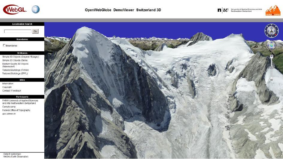
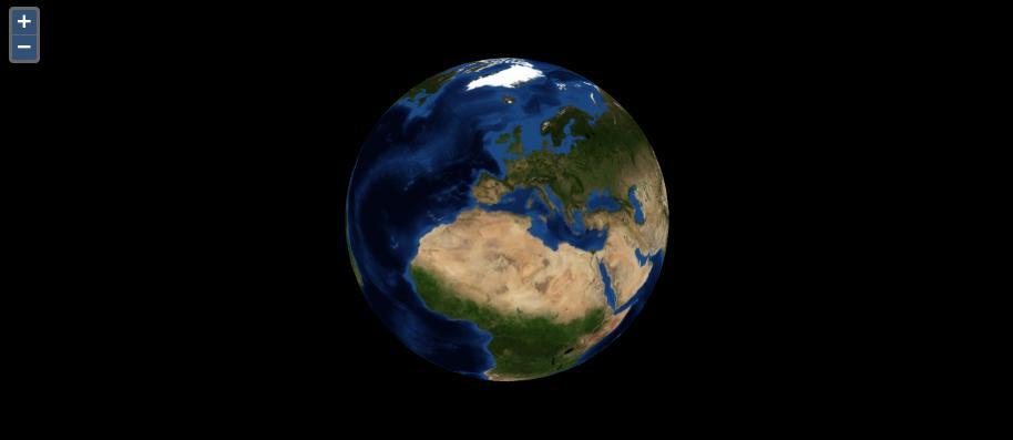
7 OpenWebGlobe 7/37

8 Cesium 8/37
9 Geospatial 3D Web expectations? 3D Scenes Aerial imagery and terrain Buildings with textures Label and marker Rich interaction (Navigate, pick, popup, measure, usw.) Global perimeter, higher local resolution Technology Web (no plugin), Cross Platform and Cross Device Open Standards and Formats Open Source What's available? 9/37
10 Web? 10/37
 WebGL Programs consist of :")
11 WebGL! Web Graphics Library Javascript API for rendering interactive 2D/3D graphics withing the webbrowser Hardware acceleration using the Graphics Processing Unit (GPU) WebGL Programs consist of : Control code written in Javascript (CPU) and Shader code that is executed on a computer's GPU No Plugin! Also in IE11!!! Mobile device ready : Firefox, Sony Android Browser, Opera 11/37
12 Open Standards? 12/37
13 Standardizing and Merging worlds Geo: OGC 3D Portrayal Services (Proposals: WVS WMS-Like & W3DS WFS-Like) KML XML/COLLADA CityGML - representation, storage, and exchange CZML (AGI/Cesium)? Geo: OSGEO Web: Web3d TMS (Cesium Terrain Server z.b) X3D - Extensible 3D Graphics Graphics: Khronos Group COLLADA exchange / interoperability gltf graphic language Transmission Format 13/37

14 3D Portrayal Service (3DPS) Goal: Standard service interface to visualize very large 3D geospatial databases online vie Web-Browser and Mobile Devices 3D Scenegraph and image based rendering 14/37
15 Model Challenges Compact object representation Progressive transfert Streaming LOD Fast Model Display Bandwith GPU intensive, reduce CPU usage Application/Software independent Standard Mesh encodings for X3DOM:Recent Advances by Max Limper and Johannes Behr, Fraunhofer IGD 16/37
16 X3D Geometries Basic primitives (Box, Cone Cylinder, Sphere) IndexedFaceSet (3D shape formed by constructing faces - polygons) <IndexedFaceSet coordindex=' etc /> <Coordinate point=' , , etc /> => Large HTML pages, CPU + Loading time X3dom optimizations Binary Geometry employs several files to store the index and geometry data directly in the requested precision Progressively Ordered Primitive (POP) Buffer 17/37
17 CZML - Cesium Language Describes Graphical scene Time-dynamic data Caracteristics JSON structure Line, points, markers, models Describes changes over time Supports datastreaming Extensible 18/37

18 gltf graphic language Transmission Format JSON used to describe node hierarchy Node hierarchy refers to EXTERNAL binary asset blobs Non-compressed asset blob format Geometry, Texturen, Material Direct load in WebGL Extensible Streaming and compression 20/37
19 Open Source Software? 21/37
20 Open Source implementations PostGIS stores and exports 3D data Geoserver Provides a W3DS API (getscene & gettile) X3D & Cesium Terrain API X3dom JS API for displaying and interacting with X3D data Three.JS Export X3D data: ST_AsX3D Rich 3D model visualisation OpenWebGlobe & CesiumJS Full geospatial suites to process and display/interact with 3D in the Web 22/37

21 PostGIS/Geoserver W3DS/X3D/X3DOM 23/37
22 X3DOM Experimental Open Source Framework Display 3D models with WebGL Web3D & W3C Standardizing Process Goal : 3D objects in the Web Easy to use (HTML5 DOM) Supports HTML Events (Ex : OnClick) 24/37

23 X3DOM JS Library 25/37
24 Three.JS Lightweight xbrowser JS library/api Goal : create and display animated 3D computer graphics on a Web browser. HTML5 SVG/WebGL Proprietary format + gltf 27/37

")
25 Three.JS examples QGIS export (c) Procedural city (c) 28/37


26 OpenWebGlobe Helps you to create your own virtual globe applications running plug-in free in a web browser Allows the visualization of large scale image, elevation or other geospatial data OpenSource (MIT License) 29/37
27 CesiumJS Javascript Software with WebGL for displaying 3D virtual globe 2D map 2.5D Collombus View Time-dynamic Scenes with CZML Multiple terrain sources Overlays : Raster : WMS, TMS, OSM, Bing & Esri Vector : gltf, CZML, KML, Shapefiles Extensible with plugins 30/37

28 Cesium 3 views, WebGL 31/37

29 CZML 3D + time-dynamic display 32/37

30 Cesium Terrain + Overlay 33/37

31 Cesium Sandcastle 34/37
32 OpenLayers 3 Cesium Integration 35/37
33 Conclusion High activity in the 3D WebGL domain Big Players set public expectations Ongoing standardizations efforts WebGL momentum (Microsoft is now on board) Consider : Dataquantity to be stored and processed in the backend Data transfer and streaming with different LODs Deliver data for the GPU, avoid CPU processing AND Provide access to semantics for the CPU Web3D implementations have limited encoding possibilities applied to the geospatial world 36/37


34
3D in the Browser with WebGL. Chris Andrews 3D Product Manager Javier Gutierrez 3D Product Engineer
 3D in the Browser with WebGL Chris Andrews 3D Product Manager Javier Gutierrez 3D Product Engineer Just sayin This is not a programming class Goal is to help you learn about a technology area that impacts
WebGL Meetup GDC Copyright Khronos Group, Page 1
 WebGL Meetup GDC 2012 Copyright Khronos Group, 2012 - Page 1 Copyright Khronos Group, 2012 - Page 2 Khronos API Ecosystem Trends Neil Trevett Vice President Mobile Content, NVIDIA President, The Khronos
X3DOM Getting declarative (X)3D into HTML
3D into HTML") X3DOM Getting declarative (X)3D into HTML WebGL BOF, Siggraph 2010 Johannes Behr & Yvonne Jung Virtual and Augmented Reality Group, Fraunhofer IGD, Darmstadt, Germany johannes.behr@igd.fraunhofer.de Motivation
X3DOM Getting declarative (X)3D into HTML WebGL BOF, Siggraph 2010 Johannes Behr & Yvonne Jung Virtual and Augmented Reality Group, Fraunhofer IGD, Darmstadt, Germany johannes.behr@igd.fraunhofer.de Motivation
Neil Trevett Vice President Mobile Ecosystem, NVIDIA President, Khronos Group. Copyright Khronos Group Page 1
 Neil Trevett Vice President Mobile Ecosystem, NVIDIA President, Khronos Group Copyright Khronos Group 2014 - Page 1 Khronos Standards 3D Asset Handling - 3D authoring asset interchange - 3D asset transmission
Implementing Web GIS Solutions
 Implementing Web GIS Solutions using open source software Karsten Vennemann Seattle Talk Overview Talk Overview Why and What What is Open Source (GIS)? Why use it? Application Components Overview of Web
BROWSER. LuciadRIA DATA SHEET
 BROWSER LuciadRIA DATA SHEET V2017 V2017.0 DATA SHEET LuciadRIA is the answer to today s demands for powerful, lightweight applications in the browser. Driven by today s most advanced web technologies,
Efficient Binary Meshes in X3DOM refined: Not just images anymore!
 Efficient Binary Meshes in X3DOM refined: Not just images anymore! Johannes Behr Yvonne Jung Tobias Franke Timo Sturm johannes.behr@igd.fraunhofer.de Declarative (X)3D in HTML Embed a live scenegraph in
gltf Briefing September 2016 Copyright Khronos Group Page 1
 gltf Briefing September 2016 Copyright Khronos Group 2016 - Page 1 Copyright Khronos Group 2016 - Page 2 Background and Motivation OpenGL ES and WebGL have led to a proliferation of Web 3D but no standard
GPGPU Applications. for Hydrological and Atmospheric Simulations. and Visualizations on the Web. Ibrahim Demir
 GPGPU Applications for Hydrological and Atmospheric Simulations and Visualizations on the Web Ibrahim Demir Big Data We are collecting and generating data on a petabyte scale (1Pb = 1,000 Tb = 1M Gb) Data
Novel Globe Publishing Techniques Using WebGL
 Mátyás Gede * Novel Globe Publishing Techniques Using WebGL Keywords: globes; internet; WebGL; X3D; Cesium Summary: Digitising old globes always brings the problem of displaying digital 3D objects. Until
Providing Interoperability Using the Open GeoServices REST Specification
 2013 Esri International User Conference July 8 12, 2013 San Diego, California Technical Workshop Providing Interoperability Using the Open GeoServices REST Specification Satish Sankaran Kevin Sigwart What
OGRS Perugia, Italy October 2016
 OGRS Perugia, Italy 12-14 October 2016 NASA WorldWind: virtual globe for an open smart city Maria Antonia Brovelli 1, Candan Eylül Kilsedar 1, Patrick Hogan 2, Gabriele Prestifilippo 1, Giorgio Zamboni
Open Source Software: What and Why?
 ESRI and Open Source A Love Story Presented by Bates Rambow Open Source Software: What and Why? What Software that has its source code published for anyone to inspect the source code. Generally released
Fulfilling the Mandate of Information Durability and Access. Nov 2, 2018
 Fulfilling the Mandate of Information Durability and Access Nov 2, 2018 Nicholas F. Polys, Ph.D. Virginia Tech, Web3D Consortium Virginia Tech (VT): Ut Prosim A land-grant University serving the Public
SkylineGlobe - Products Overview
 SkylineGlobe - Products Overview Skyline Software Systems, Inc. is a leading provider of 3D earth visualization software and services. The company offers a comprehensive platform of applications, tools
A web based BIM/GIS integration platform on top of open source
 A web based BIM/GIS integration platform on top of open source Sanghee Shin(shshin@gaia3d.com) Seongdo Son(sdson@gaia3d.com) Hakjoon Kim(hjkim@gaia3d.com) Jengdae Cheon(jdcheon@gaia3d.com)
geobrowser3d.com The Power of 3D GIS Tools in your Browser
 geobrowser3d.com 1 The Power of 3D GIS Tools in your Browser Overview Introduction Modules Success Stories Build your own What is GeoBrowser3D Interactive 3D visualization system Modular platform OGC compliant
AR Standards Update Austin, March 2012
 AR Standards Update Austin, March 2012 Neil Trevett President, The Khronos Group Vice President Mobile Content, NVIDIA Copyright Khronos Group, 2012 - Page 1 Topics Very brief overview of Khronos Update
Developing a Reference Model for Augmented Reality. 5th International AR Standards Community Meeting 19 March 2012
 Developing a Reference Model for Augmented Reality 5th International AR Standards Community Meeting 19 March 2012 What are uses of a Reference Model? Basis for coordination and understanding of the AR
WebGL Seminar: O3D. Alexander Lokhman Tampere University of Technology
 WebGL Seminar: O3D Alexander Lokhman Tampere University of Technology What is O3D? O3D is an open source JavaScript API for creating rich, interactive 3D applications in the browser Created by Google and
Visual HTML5. Human Information Interaction for Knowledge Extraction, Interaction, Utilization, Decision making HI-I-KEIUD
 Visual HTML5 1 Overview HTML5 Building apps with HTML5 Visual HTML5 Canvas SVG Scalable Vector Graphics WebGL 2D + 3D libraries 2 HTML5 HTML5 to Mobile + Cloud = Java to desktop computing: cross-platform
What s New in TerraExplorer Suite 5.0
 What s New in TerraExplorer Suite 5.0 The new release of the TerraExplorer Suite marks major improvements in the capabilities for working with GIS layers. A new streaming mechanism allows connection to
Project Deliverable. Report on 4 D models in World Wide Web of all test areas
 Project Deliverable Number D4.2 Title Month Report on 4 D models in World Wide Web of all test areas M33 Language English Revisions record Rev. N. Author Notes Date 0 Gabriele Guidi Document framework
SC24/WG9 Liaison Meeting
 Copyright Khronos Group, 2011 - Page 1 SC24/WG9 Liaison Meeting Seoul, November 2011 Neil Trevett Vice President Mobile Content, NVIDIA President, The Khronos Group Copyright Khronos Group, 2011 - Page
Visualization/dissemination of 3D Cadastral Information
 Presented at the FIG Congress 2018, May 6-11, 2018 in Istanbul, Turkey Visualization/dissemination of 3D Cadastral Information 9-5-2018 Barbara Cemellini, Rod Thompson, Marian de Vries, Peter van Oosterom
Copyright Khronos Group Page 1
 Gaming Market Briefing Overview of APIs GDC March 2016 Neil Trevett Khronos President NVIDIA Vice President Developer Ecosystem ntrevett@nvidia.com @neilt3d Copyright Khronos Group 2016 - Page 1 Copyright
pgrouting extends the postgis/postgresql geospatial database to provide geospatial routing and other network analysis functionality.
 Workshop: 1 pgrouting extends the postgis/postgresql geospatial database to provide geospatial routing and other network analysis functionality. Attendee s previous knowledge: SQL (PostgreSQL, PostGIS)
Thanks for taking the time to check out this talk! It details our work on advancing not just Cesium, but open standards for massive 3D geospatial
 Thanks for taking the time to check out this talk! It details our work on advancing not just Cesium, but open standards for massive 3D geospatial visualization on the web. 1 Cesium is an open-source JavaScript
Leveraging OGC Services in ArcGIS Server. Satish Sankaran, Esri Yingqi Tang, Esri
 Leveraging OGC Services in ArcGIS Server Satish Sankaran, Esri Yingqi Tang, Esri GIS Creating and Managing Geo Information Products - Proprietary - Open Specifications - Standards Dissemination of Geo
An Overview of FMW MapViewer
 An Overview of FMW MapViewer Agenda What is MapViewer Select Features Getting Started Additional Resources 2 Copyright 2013, Oracle and/or its affiliates. All rights reserved. Oracle
From 2D to 3D at Esri
 From 2D to 3D at Esri Paul Hardy, Esri Inc phardy@esri.com, Cambridge, UK SHORT PAPER This short paper provides an overview of the 3D capabilities of a modern GIS, illustrated by the Esri ArcGIS system,
LINKING 3D BUILDING MODELS, MAPS AND ENERGY-RELATED DATA IN A WEB-BASED VISUALIZATION SYSTEM
 LINKING 3D BUILDING MODELS, MAPS AND ENERGY-RELATED DATA IN A WEB-BASED VISUALIZATION SYSTEM R. Sihombing 1, V. Coors 1 1 University of Applied Science Stuttgart, 70174 Stuttgart, Germany - (rosanny.sihombing,
3D Data Modelling at Esri. Paul Hardy Business Development Consultant Esri Europe
 3D Data Modelling at Esri Paul Hardy phardy@esri.com Business Development Consultant Esri Europe Users of 3D GIS Local government Facilities management Civil engineering 3D GIS Defense / Public Safety
Khronos and the Mobile Ecosystem
 Copyright Khronos Group, 2011 - Page 1 Khronos and the Mobile Ecosystem Neil Trevett VP Mobile Content, NVIDIA President, Khronos Copyright Khronos Group, 2011 - Page 2 Topics It s not just about individual
Esri UC2013. Technical Workshop. Type Presentation Name Here
 Type Presentation Name Here 2013 Esri International User Conference July 8 12, 2013 San Diego, California Technical Workshop 3D Analyst An Introduction Deepinder Deol Michael Contreras Why use 3D GIS?
Brandenburg 3D a comprehensive 3D subsurface model, conception of an infrastructure node and a web application
 Brandenburg 3D a comprehensive 3D subsurface model, conception of an infrastructure node and a web application Maik Schilling 1, Andreas Simon 1, Christoph Jahnke 1, Thomas Höding 1 1 Landesamt für Bergbau,
IT Infrastructure for BIM and GIS 3D Data, Semantics, and Workflows
 IT Infrastructure for BIM and GIS 3D Data, Semantics, and Workflows Hans Viehmann Product Manager EMEA ORACLE Corporation November 23, 2017 @SpatialHannes Safe Harbor Statement The following is intended
_ LUCIADRIA V PRODUCT DATA SHEET _ LUCIADRIA PRODUCT DATA SHEET
 _ LUCIADRIA PRODUCT DATA SHEET V2016 LuciadRIA offers browser-based geospatial situational awareness with the fluidity and speed of a desktop application. The software components of LuciadRIA have been
RELEASE NOTES FOR TERRAEXPLORER 7.0.1
 s RELEASE NOTES FOR TERRAEXPLORER 7.0.1 New Features in Release 7.0.1 Raster layer enhancements Load raster layers from Google Earth Enterprise Server - TerraExplorer 7.0.1 extends imagery and elevation
Standards for WebVR. Neil Trevett. Khronos President Vice President Mobile Content,
 Standards for WebVR Neil Trevett Khronos President Vice President Mobile Content, NVIDIA ntrevett@nvidia.com, @neilt3d October 2016 Copyright Khronos Group 2016 - Page 1 Khronos Open Standards Software
It s under the liberal Apache 2.0 license, so it s usable in both free and commercial applications.
 1 2 3 So, what is Cesium? To put it succinctly, Cesium is an open-source JavaScript library for creating 3D globes and 2D maps. Cesium is used in many fields, such as geospatial, aerospace, sports, environmental
WebWorldWind, achievements and future of the ESA-NASA partnership
 WebWorldWind, achievements and future of the ESA-NASA partnership Yann Voumard 1, Paulo Sacramento 1, Pier Giorgio Marchetti 2, Patrick Hogan 3 1 Solenix Deutschland GmbH, Spreestrasse 3, 64295 Darmstadt,
3D on the Web Why We Need Declarative 3D Arguments for an W3C Incubator Group
 3D on the Web Why We Need Declarative 3D Arguments for an W3C Incubator Group Philipp Slusallek Johannes Behr Kristian Sons German Research Center for Artificial Intelligence (DFKI) Intel Visual Computing
SkylineGlobe 6.5 s New Developments
 SkylineGlobe 6.5 s New Developments The SkylineGlobe Enterprise suite of applications was created to provide all of the necessary software tools for an organization to implement their own private, 3D virtual
County of Los Angeles. Chief Information Office Preferred Technologies for Geographic Information Systems (GIS) Version 2 May 2015
 Version 2 May 2015") County of Los Angeles Chief Information Office Preferred Technologies for Geographic Information Systems (GIS) Version 2 May 2015 CIO Preferred Technologies for GIS This document lists the preferred Geographic
County of Los Angeles Chief Information Office Preferred Technologies for Geographic Information Systems (GIS) Version 2 May 2015 CIO Preferred Technologies for GIS This document lists the preferred Geographic
OPEN SOURCE SOLUTIONS FOR SURVEYORS
 2 nd Sabah International Surveyors Congress 11 th 12 th March 2014 OPEN SOURCE SOLUTIONS FOR SURVEYORS Presented By : Sr Alexander Chong Director, Jurukur Antarabangsa The Benefits Of Closed Proprietary
From 2D to 3D at Esri
 From 2D to 3D at Esri OGC/EuroSDR workshop on CityGML in National Mapping Paul Hardy phardy@esri.com Business Development Consultant National Mapping & Cadastre Esri 3D GIS Visualize Manage Share Analyze
ISO/IEC/Web3D Status Report
 January 22, 2019 ISO/IEC/Web3D Status Report Dr. Richard F. Puk President, Intelligraphics Incorporated Convener, ISO/IEC JTC 1/SC 24/WG 6 ISO/IEC JTC1/SC24 Liaison to Web3D Consortium Web3D-related Standards
Single and Multiple Thread Programming for Geo-visualization by Using WebGL with Web Workers
 , 23-25 October, 2013, San Francisco, USA Single and Multiple Thread Programming for Geo-visualization by Using WebGL with Web Workers Hyung Woo Kim, Yang-Won Lee Abstract So far, various web elements
WebGL (Web Graphics Library) is the new standard for 3D graphics on the Web, designed for rendering 2D graphics and interactive 3D graphics.
 is the new standard for 3D graphics on the Web, designed for rendering 2D graphics and interactive 3D graphics.") About the Tutorial WebGL (Web Graphics Library) is the new standard for 3D graphics on the Web, designed for rendering 2D graphics and interactive 3D graphics. This tutorial starts with a basic introduction
About the Tutorial WebGL (Web Graphics Library) is the new standard for 3D graphics on the Web, designed for rendering 2D graphics and interactive 3D graphics. This tutorial starts with a basic introduction
Web Map Servers. Mark de Blois. Septembre 2016
 Web Map Servers Mark de Blois Septembre 2016 Learning Objectives After this lecture you will be able to understand web map servers as used in Web-GIS applications Introduction A Web Map Server is a computer
Ciril Bohak. - INTRODUCTION TO WEBGL
 2016 Ciril Bohak ciril.bohak@fri.uni-lj.si - INTRODUCTION TO WEBGL What is WebGL? WebGL (Web Graphics Library) is an implementation of OpenGL interface for cmmunication with graphical hardware, intended
Copyright Khronos Group, Page 1. Khronos Overview. Taiwan, February 2012
 Copyright Khronos Group, 2012 - Page 1 Khronos Overview Taiwan, February 2012 Copyright Khronos Group, 2012 - Page 2 Khronos - Connecting Software to Silicon Creating open, royalty-free API standards -
Getting Started with the ArcGIS Server JavaScript API
 Getting Started with the ArcGIS Server JavaScript API Agenda Introduction ArcGIS Server services and mashups REST API Services Directory JavaScript API ArcGIS Server Resource Center Dojo Maps, layers,
Visualization with ArcGlobe. Brady Hoak
 Visualization with ArcGlobe Brady Hoak Contents What is ArcGlobe? 3D Mapping and ArcGlobe Displaying data in ArcGlobe ArcGlobe tools Tips for constructing ArcGlobe documents New at ArcGIS 9.3 ArcGIS integration
May 22, 2013 Ronald Reagan Building and International Trade Center Washington, DC USA
 May 22, 2013 Ronald Reagan Building and International Trade Center Washington, DC USA 1 Building Applications with Oracle MapViewer LJ Qian (lj.qian@oracle.com) Director, Software Development The following
RELEASE NOTES FOR TERRAEXPLORER FOR WEB 7.2
 RELEASE NOTES FOR TERRAEXPLORER FOR WEB 7.2 About TerraExplorer for Web TerraExplorer for Web (TE4W) is a lightweight 3D GIS viewer that enables you to view and analyze highresolution, stunningly realistic
Lecture note on the history and principles of geo-webservices
 A SHORT INTRODUCTION TO GEO-WEBSERVICES Lecture note on the history and principles of geo-webservices Barend Köbben Version 1.0 February 24, 2010 Contents 1 From monolithic to distributed GIS architectures
NEW FEATURES IN RELEASE 7.0
 Native 64bit Application NEW FEATURES IN RELEASE 7.0 TerraExplorer 7.0 has been redesigned as a native 64 bit application, enabling TerraExplorer to take advantage of available memory for resource-intensive
Getting Started with the ArcGIS API for JavaScript. Julie Powell, Paul Hann
 Getting Started with the ArcGIS API for JavaScript Julie Powell, Paul Hann Esri Developer Summit Berlin November 19 2012 Getting Started with the ArcGIS API for JavaScript ArcGIS for Server Is a Platform
Overview and AR/VR Roadmap
 Khronos Group Inc. 2018 - Page 1 Overview and AR/ Roadmap Neil Trevett Khronos President NVIDIA VP Developer Ecosystems ntrevett@nvidia.com @neilt3d Khronos Group Inc. 2018 - Page 2 Khronos Connects Software
Qiufeng Zhu Advanced User Interface Spring 2017
 Qiufeng Zhu Advanced User Interface Spring 2017 Brief history of the Web Topics: HTML 5 JavaScript Libraries and frameworks 3D Web Application: WebGL Brief History Phase 1 Pages, formstructured documents
TOCOMEE: A topological, coloured model of the Earth's elevation
 TOCOMEE: A topological, coloured model of the Earth's elevation Dr. Michael Nolde German Aerospace Center (DLR) mno@flatpolar.org Abstract The presented dataset provides free global, topological, coloured
WebGL, WebCL and Beyond!
 Copyright Khronos Group, 2011 - Page 1 WebGL, WebCL and Beyond! Neil Trevett Vice President Mobile Content, NVIDIA President, The Khronos Group Copyright Khronos Group, 2011 - Page 2 Topics in this Session
Achieving Interoperability using the ArcGIS Platform. Satish Sankaran Roberto Lucchi
 Achieving Interoperability using the ArcGIS Platform Satish Sankaran Roberto Lucchi Thank you Please fill out the session survey in your mobile app Select [Achieving Interoperability using the ArcGIS Platform]
Visualizing 3D geology in web browsers using X3DOM
 Visualizing 3D geology in web browsers using X3DOM Øystein Malt a, Atle Geitung a, Harald Soleim a, Daniel Patel ab a Western Norway University of Applied Sciences (HVL) b Christian Michelsen Research
Khronos Updates GDC 2017 Neil Trevett Vice President Developer Ecosystem, NVIDIA President,
 Copyright Khronos Group 2017 - Page 1 Khronos Updates GDC 2017 Neil Trevett Vice President Developer Ecosystem, NVIDIA President, Khronos ntrevett@nvidia.com @neilt3d Copyright Khronos Group 2017 - Page
3D in the ArcGIS Platform. Chris Andrews
 3D in the ArcGIS Platform Chris Andrews Geospatial 3D is already all around us 3D is expanding the GIS community s opportunity to provide value 3D City & Infrastructure Models Generated 3D features Photogrammetrc
EDINA Workshop: Creating a Campus Map and Displaying it in OpenLayers
 Contents Introduction... 2 What steps are involved?... 3 Before you start... 4 Create your campus map... 5 1. Load the basemap data into ArcMap... 5 2. Set up Symbology and Labels of Layers... 6 Improve
The Butterfly Effect. A proposal for distribution and management for butterfly data programs. Dave Waetjen SESYNC Butterfly Workshop May 10, 2012
 The Butterfly Effect A proposal for distribution and management for butterfly data programs Dave Waetjen SESYNC Butterfly Workshop May 10, 2012 http://butterfly.ucdavis.edu Citizen Science based Observation
Ecosystem Forum. SIGGRAPH, August 2018 Neil Trevett, Khronos President. Copyright Khronos Group Page 1
 Ecosystem Forum SIGGRAPH, August 2018 Neil Trevett, Khronos President Copyright Khronos Group 2018 - Page 1 Copyright Khronos Group 2018 - Page 2 Welcome! And Logistics! WiFi: DonnellygGroupPubs-Guest
Content Visualization Issues
 Name Sanobar Nishat (113052001) MTP : Implementation Issues of Visualization on Small screen devices Report: Summary Report 4 (week 4) Date: 4 Feb 13 Summary: Graphical data visualization is used to display
[ ]..,ru. GeoServer Beginner's Guide. open source^ software server. Share and edit geospatial data with this open source.
![[ ]..,ru. GeoServer Beginner's Guide. open source^ software server. Share and edit geospatial data with this open source.](/thumbs/80/80955530.jpg "[ ]..,ru. GeoServer Beginner's Guide. open source^ software server. Share and edit geospatial data with this open source.") GeoServer Beginner's Guide Share and edit geospatial data with this open source software server Stefano lacovella Brian Youngblood [ ]..,ru open source^ PUBLISHING community experience distilled BIRMINGHAMMUMBAI
GeoServer Beginner's Guide Share and edit geospatial data with this open source software server Stefano lacovella Brian Youngblood [ ]..,ru open source^ PUBLISHING community experience distilled BIRMINGHAMMUMBAI
Caching Tile Cache Creation & Management
 Exploring Options for Map Caching Tile Cache Creation & Management Presented By: Todd Wascher, Business Development Manager 04.21.2011 We Visualize Your World Whachutalkinbout? What we ll cover with this
Open source technologies and INSPIRE network services in Slovak environmental agency
 Open source technologies and INSPIRE network services in Slovak environmental agency Peter Mozolík, Martin Koška, Marek Žiačik, Martin Tuchyňa Slovak Environmental Agency (SEA) SEA role within slovak SDI
Dynamic 3D representation of information using low cost Cloud ready Technologies
 National Technical University Of Athens School of Rural and Surveying Engineering Laboratory of Photogrammetry Dynamic 3D representation of information using low cost Cloud ready Technologies George MOURAFETIS,
Leveraging OGC Services in ArcGIS Server
 Esri International User Conference San Diego, CA Technical Workshops Jul.14 th 2011 Leveraging OGC Services in ArcGIS Server Satish Sankaran Yingqi Tang Agenda Interoperability
Inside Biosphere3D The free digital globe from a developer prospect. Steffen Ernst
 The free digital globe from a developer prospect Steffen Ernst Page 2 Short Description Biosphere3D targets interactive landscape rendering based on a virtual globe Input data: DEM, satellite and aerial
CHAPTER 5 DIGITAL ELEVATION MODEL AND 3D VISUALIZATION
 CHAPTER 5 DIGITAL ELEVATION MODEL AND 3D VISUALIZATION A digital elevation model (DEM) is a digital model or 3D representation of a terrain's surface. A DEM can be represented as a raster (a grid of squares,
Next Generation OpenGL Neil Trevett Khronos President NVIDIA VP Mobile Copyright Khronos Group Page 1
 Next Generation OpenGL Neil Trevett Khronos President NVIDIA VP Mobile Ecosystem @neilt3d Copyright Khronos Group 2015 - Page 1 Copyright Khronos Group 2015 - Page 2 Khronos Connects Software to Silicon
gltf 2.0: Status and Outlook
 gltf 2.0: Status and Outlook 31st July 2018 by Norbert Nopper (nopper@ux3d.io, @McNopper) Content Status (15 minutes) Outlook (35 minutes) Questions & Answers (10 minutes) Status gltf 2.0 What we currently
PHYSICS SUPPORT IN WEB3D ENVIRONMENTS ANDREAS STAMOULIAS
 PHYSICS SUPPORT IN WEB3D ENVIRONMENTS by ANDREAS STAMOULIAS Master in Informatics and Multimedia, Department of Informatics Engineering, School of Applied Technology, Technological Educational Institute
Creating, managing and utilizing a 3D Virtual City in ArcGIS Tamrat Belayneh Eric Wittner
 Creating, managing and utilizing a 3D Virtual City in ArcGIS 10.1 Tamrat Belayneh (tbelayneh@esri.com) Eric Wittner (ewittner@esri.com ) Contents 3D Mapping & Ingredients of a 3D Virtual City Creating
Qgis2threejs plugin Documentation
 Qgis2threejs plugin Documentation Release 2.0 Minoru Akagi May 16, 2018 Contents 1 Examples 3 2 Tutorial 7 3 Exporter 13 4 Object Types 23 5 Web Viewer 33 6 Development 35 i ii Note: Now being updated
By Robert Slivinsky 1
 By Robert Slivinsky 1 Tell HC Mobile Application SQL Server 2008 GeoServer GeoExt- Open Layers 2 3 Desktop Splash Page 2 sec GPS/Location Approval 4 Homepage Meat - Form Categories from EOCcalls 5 Description
Adopting the Appropriate GIS Web Service Technologies
 Adopting the Appropriate GIS Web Service Technologies Bo Guo, PE, PhD GIS/IT Integration Consultant Gistic Research Inc. UT & AZ Jake Payne Database Administrator & Architect State of Utah Department of
SkylineGlobe Web Package Version 6.1 Release Notes
 SkylineGlobe Web Package Version 6.1 Release Notes Information contained in this document is subject to change without notice and does not represent a commitment on behalf of Skyline Software Systems Inc.
QGIS Plugins FOSS4G From Must-Haves to insider Sourcepole AG, Switzerland
 FOSS4G 2015 From Must-Haves to insider tips @PirminKalberer Sourcepole AG, Switzerland www.sourcepole.com About Sourcepole > QGIS > > > > Core dev. & Project Steering Commitee QGIS Server, Printing, Plugins,
Thematic Maps on Virtual Globes
 Thematic Maps on Virtual Globes Mátyás Gede Department of Cartography and Geoinformatics, Eötvös Loránd University, Hungary Abstract. With the emerge of virtual globes several new visualization methods
X3D Efficient Binary Encoding (EBE)
") X3D Efficient Binary Encoding (EBE) Background and Overview Web3D 2015 Conference Heraklion Crete, 18 June 2015 1 Long straight trail has led here... Compressed Binary Encoding (CBE) Call for Contributions
X3D Efficient Binary Encoding (EBE) Background and Overview Web3D 2015 Conference Heraklion Crete, 18 June 2015 1 Long straight trail has led here... Compressed Binary Encoding (CBE) Call for Contributions
Bentley Descartes and what s new in Descartes V8i (SELECTseries 3) What is Bentley Descartes? 2011 Bentley Systems, Incorporated
 What is Bentley Descartes? 2011 Bentley Systems, Incorporated") Bentley Descartes and what s new in Descartes V8i (SELECTseries 3) Tom Stogdill Bentley Systems, Inc. What is Bentley Descartes? Image Processing Raster Geo-Referencing Advanced raster transformation (warping,
Bentley Descartes and what s new in Descartes V8i (SELECTseries 3) Tom Stogdill Bentley Systems, Inc. What is Bentley Descartes? Image Processing Raster Geo-Referencing Advanced raster transformation (warping,
SRC - A Streamable Format for Generalized Web-based 3D Data Transmission
 SRC - A Streamable Format for Generalized Web-based 3D Data Transmission Max Limper 1,2 Maik Thöner 1 Johannes Behr 1 Dieter W. Fellner 1,2 1 Fraunhofer IGD 2 TU Darmstadt (a) 17% triangles, low-resolution
Developing a Free and Open Source Software based Spatial Data Infrastructure. Jeroen Ticheler
 Developing a Free and Open Source Software based Spatial Data Infrastructure Jeroen Ticheler 1 License This work is licensed under the Creative Commons Attribution-NonCommercial-ShareAlike 2.5 License.
EUCOM/AFRICOM DEFENSE USER GROUP MEETING MARCH 2010 STUTTGART WELCOME!
 EUCOM/AFRICOM DEFENSE USER GROUP MEETING 23-25 MARCH 2010 STUTTGART WELCOME! AGENDA March 23, Tuesday 0800-0900 Registration 0900-0915 Welcome and Introductions 0915-1000 Getting Started with ArcGIS Server
WebGL and the Three-D Internet. Hugh Fisher CECS ANU 2013
 WebGL and the Three-D Internet Hugh Fisher CECS ANU 2013 The Vision: origins of cyberspace The rendering problem VRML: the grand attempt XAML: the Microsoft web gets 3D WebGL: what it can do The Future?
TerraExplorer Quick Start Guide
 TerraExplorer Quick Start Guide Basic Concepts Opening, Creating, and Saving.. 1 Navigating in the 3D Window... 1 Using the Project Tree... 2 System Requirements... 2 Project Settings Controlling Date
Regarding the quality attributes, the architecture of the system must be:
 The SDSS System Overview This chapter gives an overview of the software architecture of the RiskChanges SDSS system. One of the objectives within the project is the development of a SDSS system for probabilistic
Version Datasheet
 Version 5.1.2 w w w. S k y l i n e G l o b e. c o m Table of Contents Overview... 2 Product Main Features... 3 Layers... 4 Objects... 7 Measurement and Analysis... 11 Programming with TerraExplorer Pro...
Mobile AR Hardware Futures
 Copyright Khronos Group, 2010 - Page 1 Mobile AR Hardware Futures Neil Trevett Vice President Mobile Content, NVIDIA President, The Khronos Group Two Perspectives NVIDIA - Tegra 2 mobile processor Khronos
Introduction to X3D. Roberto Ranon HCI Lab University of Udine, Italy
 Introduction to X3D Roberto Ranon ranon@dimi.uniud.it HCI Lab University of Udine, Italy http://hcilab.uniud.it Outline What is X3D? X3D basics including some new capabilities and details on the (near)