From Geoportal to Spatial Data Service Platform. Jani Kylmäaho National Land Survey of Finland Development Centre
|
|
|
- Rafe Goodman
- 5 years ago
- Views:
Transcription

1 From Geoportal to Spatial Data Service Platform Jani Kylmäaho National Land Survey of Finland Development Centre
2 Introduction National Land Survey of Finland employees Development Centre employees SDI Team - 8 employees Focus on supporting the development of a national SDI with INSPIRE compatibility Authors Jani Kylmäaho, Product Owner, SD Service Platform Antti Rainio, Team Leader, SDI team
3 Finnish Reference Architecture for SDI Services Description of how to achieve interoperability of Geographic Information systems, services and content Based on European INSPIRE legislation and international standards
4 Finnish public sector reference architecture for SDI services Geographical Information Systems Portals and clients Interoperable components / Mashups APPLICATION LAYER Federation security Rights management Spatial data service bus AUTHENTICATION & AUTHORISATION LAYERS Spatial Data Service Platforms Support services Licence services Metadata Services CSW Content Services WMS WMTS WFS WCS Transformation services Analysis services WPS Portrayal services Storage services Software services SaaS SERVICE LAYER Metadata Data sources Data products DATA LAYER
5 Finnish Reference Architecture for SDI Services Consists of five main layers: Content layer Service layer Authorisation layer Authentication layer Application layer The SD Service Platform binds the five layers together Enables users to publish content through standardised services securely into any web applications or portals
6 Spatial Data Service Platforms Spatial Data Service Platforms enable efficient browser-based utilisation of spatial data and services through the web as cloud services Portal for ArcGIS / ArcGIS Online opengeoportal

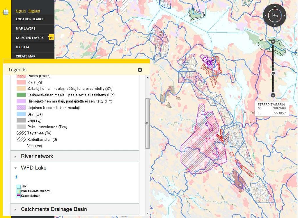
7 National geoportal About 1300 daily users, 9500 registered users Embedded maps / Service platform, My Places, ~ 20 data providers, ~ 300 map layers


8 Open Source Geoportal Open source code libraries OpenLayers jquery Liferay GeoNetwork GeoServer, GeoWebCache PostgreSQL, PostGIS Linux, Apache, Tomcat

9 Open Source Map Application Framework
10 Open Source Spatial Data Service Platform - OSKARI OSKARI is the core of an Open Source based Spatial Data Service Platform key principals: Supports implementation of the SDI Inspire compatible Standards based (OGC, ISO) Use existing OS components: e.g. OpenLayers, jquery All developed code is released under OS licenses (MIT/ EUPL) Java/Javascript based Functionality both on the server and client side

11 Other SDS platforms Geoportal.fi Oskari
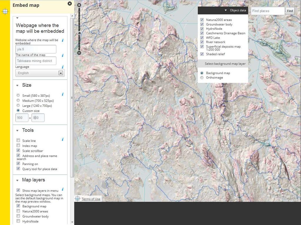
12 OSKARI SDS Geoportal.fi Users can publish an embedded map into any common web content management system (CMS), utilizing the rich content from the Finnish/Inspire SDI The embeddable map client has now basic functionality Zooming, panning, index map Selection of background map WMS GetFeatureInfo Layer selection Address and gazetteer search etc. Data for the map client can be provided through standard INSPIRE-approved OGC interfaces(wms/wmts, WFS) but soon also using REST/JSON

13 Google Maps SD Service Platform

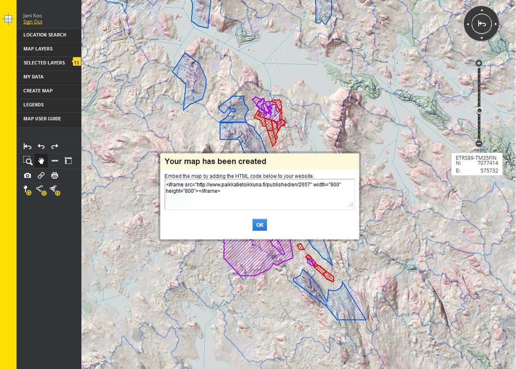
14 ArcGIS Online SD Service Platform

15 OSKARI-based SD Service Geoportal.fi
16 OSKARI-based SDI Service Platform The Clue: being able to define and publish a map UI on a web page without having to write code, using OS SDS Defining a simple map UI is possible within a few minutes; defining a more complex map UI can take tens of minutes or hours => multifold increase in productivity as compared to traditional ways of publishing a map UI Rich national / Inspire data content from multiple data providers available for publishing

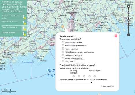
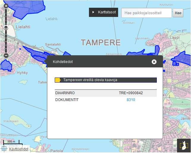
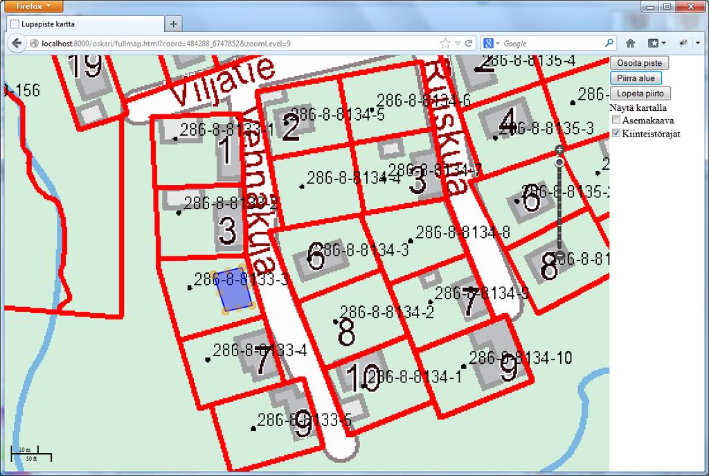
17 Example: City of Tampere planning areas

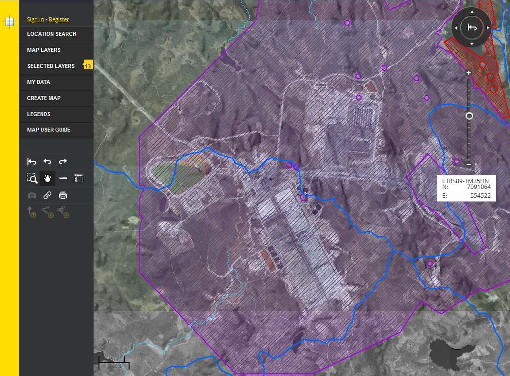
18 Example: Talvivaara mining district
19
20

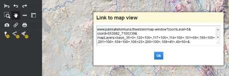
21 How to do this as an embedded map?
22
23

24 Talvivaara coverage with embedded map
25 Why OSKARI? Open Source collaboration Interoperability in the SDI Support for OGC standards and INSPIRE Architecture considerations Modularity flexibility, adaptability, performance OSKARI is an organized way of building geospatial applications Possibility to exchange e.g. user interface libraries Avoiding lock-up situations with software components or technologies (including even OpenLayers) Localization needs
26 OSKARI SDS further development - Geospatial web applications Functionality of the source code and the platform to be extended to cover more use cases, e.g. Building permit web services for municipalities the Finnish Ministry of Environment Questionnaire tool for municipalities the Finnish Ministry of Environment Statistical evaluation of basic services, such as health care and safety services the Regional State Admin Agencies Candidate technology for European Location Framework (E.L.F) platform EuroGeographics project application Your project?
27
28
29

30 Some Proofs of Concept
31
32

33 Some concepts
34
35
36
37
38
39 OSKARI wiki

40 OSKARI GitHub repository

41 Be smart > Be open minded! Open standards Open source code Open data Open services
42 More information Do contact us if you wish to work with Oskari! Thank You! Questions?
43
INSPIRE: The ESRI Vision. Tina Hahn, GIS Consultant, ESRI(UK) Miguel Paredes, GIS Consultant, ESRI(UK)
 Miguel Paredes, GIS Consultant, ESRI(UK)") INSPIRE: The ESRI Vision Tina Hahn, GIS Consultant, ESRI(UK) Miguel Paredes, GIS Consultant, ESRI(UK) Overview Who are we? Introduction to ESRI Inc. and ESRI(UK) Presenters ArcGIS The ESRI Solution to
INSPIRE: The ESRI Vision Tina Hahn, GIS Consultant, ESRI(UK) Miguel Paredes, GIS Consultant, ESRI(UK) Overview Who are we? Introduction to ESRI Inc. and ESRI(UK) Presenters ArcGIS The ESRI Solution to
SII Law Organization Coordination activities Examples of good practices Education Technical matters Success stories Challenges
 SII Law Organization Coordination activities Examples of good practices Education Technical matters Success stories Challenges INSPIRE transposed by the legal act on Spatial Information Infrastructure
GeoPortal 4 Everybody
 GeoPortal 4 Everybody Karel Charvát, Jáchym Čepický, Štěpán Kafka, Premysl Vohnout, Martin Vlk Czech Centre for Science and Society Help Service Remote Sensing DT Member What is GeoPortal GeoPortal is
Initial Operating Capability & The INSPIRE Community Geoportal
 INSPIRE Conference, Rotterdam, 15 19 June 2009 1 Infrastructure for Spatial Information in the European Community Initial Operating Capability & The INSPIRE Community Geoportal EC INSPIRE GEOPORTAL TEAM
Achieving Interoperability using the ArcGIS Platform. Satish Sankaran Roberto Lucchi
 Achieving Interoperability using the ArcGIS Platform Satish Sankaran Roberto Lucchi Thank you Please fill out the session survey in your mobile app Select [Achieving Interoperability using the ArcGIS Platform]
Browsing and downloading Spatial Data through WFS web client case National Geoportal of Finland
 Browsing and downloading Spatial Data through web client case National Geoportal of Finland INSPIRE conference 2011 28th June, 2011 Jani Kylmäaho National Land Survey of Finland 1 NATIONAL LAND SURVEY
Augmenting Thematic Maps with Data Driven Graphics by Integrating Open APIs and Mapping Platforms. Umit Dost
 Augmenting Thematic Maps with Data Driven Graphics by Integrating Open APIs and Mapping Platforms Umit Dost Agenda Background Research question Case study- PxWEB and data visualizations on Oskari Visualization
The European Location Framework (ELF) Project One Source for Reference Geo Information for Europe
 Project One Source for Reference Geo Information for Europe") The European Location Framework (ELF) Project One Source for Reference Geo Information for Europe Presentation to: By: Date: ICC Dresden Antti Jakobsson, Technical Coordinator 28 th August 2013 The ELF
The European Location Framework (ELF) Project One Source for Reference Geo Information for Europe Presentation to: By: Date: ICC Dresden Antti Jakobsson, Technical Coordinator 28 th August 2013 The ELF
Web Map Servers. Mark de Blois. Septembre 2016
 Web Map Servers Mark de Blois Septembre 2016 Learning Objectives After this lecture you will be able to understand web map servers as used in Web-GIS applications Introduction A Web Map Server is a computer
Multimodal Planner: From Prototype to Production. Francisco José Peñarrubia, SCOLAB Software Colaborativo, Spain
 268 POSTERS RESEARCH CONFERENCES Multimodal Planner: From Prototype to Production Author Francisco José Peñarrubia, SCOLAB Software Colaborativo, Spain KEYWORDS : planner, multimodal, smart city, bus,
Providing Interoperability Using the Open GeoServices REST Specification
 2013 Esri International User Conference July 8 12, 2013 San Diego, California Technical Workshop Providing Interoperability Using the Open GeoServices REST Specification Satish Sankaran Kevin Sigwart What
Introduction to INSPIRE. Network Services
 Introduction to INSPIRE. Network Services European Commission Joint Research Centre Institute for Environment and Sustainability Digital Earth and Reference Data Unit www.jrc.ec.europa.eu Serving society
OPEN SOURCE SOLUTIONS FOR SURVEYORS
 2 nd Sabah International Surveyors Congress 11 th 12 th March 2014 OPEN SOURCE SOLUTIONS FOR SURVEYORS Presented By : Sr Alexander Chong Director, Jurukur Antarabangsa The Benefits Of Closed Proprietary
Compass INSPIRE Services. Compass INSPIRE Services. White Paper Compass Informatics Limited Block 8, Blackrock Business
 Compass INSPIRE Services White Paper 2010 Compass INSPIRE Services Compass Informatics Limited Block 8, Blackrock Business Park, Carysfort Avenue, Blackrock, County Dublin, Ireland Contact Us: +353 1 2104580
SDI Tecnological Components and Standards
 SDI Tecnological Components and Standards Salvador Bayarri sbayarri@gmail.com World Bank Consultant Contents The SDI architecture model Software components: the SDI stack Basic services Metadata SDI access
The Butterfly Effect. A proposal for distribution and management for butterfly data programs. Dave Waetjen SESYNC Butterfly Workshop May 10, 2012
 The Butterfly Effect A proposal for distribution and management for butterfly data programs Dave Waetjen SESYNC Butterfly Workshop May 10, 2012 http://butterfly.ucdavis.edu Citizen Science based Observation
DATA SHARING AND DISCOVERY WITH ARCGIS SERVER GEOPORTAL EXTENSION. Clive Reece, Ph.D. ESRI Geoportal/SDI Solutions Team
 DATA SHARING AND DISCOVERY WITH ARCGIS SERVER GEOPORTAL EXTENSION Clive Reece, Ph.D. ESRI Geoportal/SDI Solutions Team Geoportal Extension for ArcGIS Server Context within an Enterprise Spatial Data Infrastructure
INSPIRE & Environment Data in the EU
 INSPIRE & Environment Data in the EU Andrea Perego Research Data infrastructures for Environmental related Societal Challenges Workshop @ pre-rda P6 Workshops, Paris 22 September 2015 INSPIRE in a nutshell
NFMS web portals Focus on monitoring functions
 NFMS web portals Focus on monitoring functions National Forest Monitoring System web portal to disseminate forest-related geospatial data on the web Dr. Inge Jonckheere, FAO UN-REDD October 2014, Hanoi,
Leveraging OGC Services in ArcGIS Server. Satish Sankaran Yingqi Tang
 Leveraging OGC Services in ArcGIS Server Satish Sankaran ssankaran@esri.com Yingqi Tang ytang@esri.com Agenda Interoperability Enablers OGC and esri OGC Web Services ArcGIS and OGC Web Services - @ version
ELF- joining Europe together
 ELF- joining Europe together An open standard based multinational web mapping project, building on INSPIRE Presentation to: ISO/TC211 Standards in Action Workshop By: Date: Jari Reini 10 th June 2015 19
GeoNode Intro & Demo
 GeoNode Intro & Demo Cristiano Giovando - Global Facility for Disaster Reduction and Recovery, World Bank Paolo Corti - Center for Geographic Analysis, Harvard University Dynamic Mapping of Secondary Cities
Harvard Hypermap: An Open Source Framework for Making the World's Geospatial Information more Accessible
 American Association of Geographers Boston, Massachusetts April, 2017 Harvard Hypermap: An Open Source Framework for Making the World's Geospatial Information more Accessible Benjamin Lewis, Paolo Corti,
Webservice-energy.org GEO Community Portal & Spatial Data Infrastructure for Energy
 Webservice-energy.org GEO Community Portal & Spatial Data Infrastructure for Energy Lionel Menard / Oct. 23 2017 Centre Observation, Impacts, Energy Research activities: Use of Earth observation data (Models,
INSPIRE tools What's new?
 INSPIRE tools What's new? Michael Lutz INSPIRE Conference, Antwerp 18 September 2018 Joint Research Centre The European Commission s science and knowledge service INSPIRE reference validator Why a reference
European Location Framework (ELF) acting as a facilitator implementing INSPIRE
 acting as a facilitator implementing INSPIRE") www.eurogeographics.org European Location Framework (ELF) acting as a facilitator implementing INSPIRE Saulius Urbanas, Mick Cory (EuroGeographics) 29 October 2016 Copyright 2013 EuroGeographics EuroGeographics
www.eurogeographics.org European Location Framework (ELF) acting as a facilitator implementing INSPIRE Saulius Urbanas, Mick Cory (EuroGeographics) 29 October 2016 Copyright 2013 EuroGeographics EuroGeographics
Achieving Interoperability Using Open Standards
 FedGIS Conference February 24 25, 2016 Washington, DC Achieving Interoperability Using Open Standards Satish Sankaran Marten Hogeweg Agenda Understanding Interoperability What, Why and How? ArcGIS Platform
SDI SOLUTIONS FOR INSPIRE: TECHNOLOGIES SUPPORTING A FRAMEWORK OF COOPERATION
 SDI SOLUTIONS FOR INSPIRE: TECHNOLOGIES SUPPORTING A FRAMEWORK OF COOPERATION Roberto Lucchi 1, Marten Hogeweg 1, Guenther Pichler 2 1 Esri, Redlands, CA, USA 2 Esri Kranzberg, Germany 1 Vision INSPIRE
OSGeo Web Mapping Typification: GeoMajas, Mapbender, MapFish and OpenLayers. Christoph Baudson Arnulf Christl FOSS4G 2010 Barcelona
 OSGeo Web Mapping Typification: GeoMajas, Mapbender, MapFish and OpenLayers Christoph Baudson Arnulf Christl FOSS4G 2010 Barcelona Disclaimer All information contained in this presentation has been compiled
Open source technologies and INSPIRE network services in Slovak environmental agency
 Open source technologies and INSPIRE network services in Slovak environmental agency Peter Mozolík, Martin Koška, Marek Žiačik, Martin Tuchyňa Slovak Environmental Agency (SEA) SEA role within slovak SDI
OpenData and INSPIRE with GeoServer, GeoNetwork and MapStore: lessons learned from real-world use cases
 OpenData and INSPIRE with GeoServer, GeoNetwork and MapStore: lessons learned from real-world use cases Ing. Simone Giannecchini, GeoSolutions Silvana Griffa, CSI Piemonte Giovanni Menduni, City of Florence
The GeoPortal Cookbook Tutorial
 The GeoPortal Cookbook Tutorial Wim Hugo SAEON/ SAEOS SCOPE OF DISCUSSION Background and Additional Resources Context and Concepts The Main Components of a GeoPortal Architecture Implementation Options
Discovery and Access of Geospatial Resources Using GIS Portal Toolkit Marten Hogeweg Product Manager GIS Portal Toolkit
 Discovery and Access of Geospatial Resources Using GIS Portal Toolkit Marten Hogeweg Product Manager GIS Portal Toolkit Outline Elements of Spatial Data Infrastructures Current trends Position of GIS portals
Testing - an essential aspect of establishing an SDI
 Testing - an essential aspect of establishing an SDI Clemens Portele, Anders Östman, Michael Koutroumpas, Xin He, Janne Kovanen, Markus Schneider, Andriani Skopeliti INSPIRE Conference 2011 30 June 2011
Implementing GeoDRM support in an OpenLayers based viewer Access to the French geoportal WMS-C services from the Spanish SDI
 INSPIRE Conference 2011 Implementing GeoDRM support in an OpenLayers based viewer Access to the French geoportal WMS-C services from the Spanish SDI R. Béjar, M. Á. Latre, J. Valiño, F. Javier Zarazaga-Soria,
ArcGIS 9.2 Works as a Complete System
 ArcGIS 9.2 Works as a Complete System A New Way to Manage and Disseminate Geographic Knowledge Author/Serve/Use Maps Data Models Globes Metadata Use Desktop Explorer Web Map Viewer Mobile Open APIs Enterprise
INSPIRE overview and possible applications for IED and E-PRTR e- Reporting Alexander Kotsev
 INSPIRE overview and possible applications for IED and E-PRTR e- Reporting Alexander Kotsev www.jrc.ec.europa.eu Serving society Stimulating innovation Supporting legislation The European data puzzle 24
pgrouting extends the postgis/postgresql geospatial database to provide geospatial routing and other network analysis functionality.
 Workshop: 1 pgrouting extends the postgis/postgresql geospatial database to provide geospatial routing and other network analysis functionality. Attendee s previous knowledge: SQL (PostgreSQL, PostGIS)
ARCHITECTURE OF SPATIAL DATA INFRASTRUCTURE (SDI) (DRAFT)
 (DRAFT)") ARCHITECTURE OF SPATIAL DATA INFRASTRUCTURE (SDI) (DRAFT) Author: Carlo Cipolloni September 20, 2018 Version 1.0 A SDI platform to support the SEIS in the ENP South region Introduction Based on the Contribution
ARCHITECTURE OF SPATIAL DATA INFRASTRUCTURE (SDI) (DRAFT) Author: Carlo Cipolloni September 20, 2018 Version 1.0 A SDI platform to support the SEIS in the ENP South region Introduction Based on the Contribution
SAFER the GIGAS Effect
 SAFER the GIGAS Effect How INSPIRE, GMES and GEOSS are influencing EC projects Arnaud Cauchy 23/06/2010 Agenda GIGAS Project Summary SAFER Project Summary SAFER Original Approach GIGAS Influences SAFER
GENeric European Sustainable Information Space for Environment.
 GENeric European Sustainable Information Space for Environment http://www.genesis-fp7.eu/ Outline Introduction The GENESIS FP7 project The GENESIS solution s architecture GENESIS experience with INSPIRE
Standards, standardisation & INSPIRE Status, issues, opportunities
 Standards, standardisation & INSPIRE Status, issues, opportunities INSPIRE Coordination Team 6 th MIG meeting, 13-14 June 2017 Joint Research Centre The European Commission's science and knowledge service
Leveraging OGC Services in ArcGIS Server. Satish Sankaran, Esri Yingqi Tang, Esri
 Leveraging OGC Services in ArcGIS Server Satish Sankaran, Esri Yingqi Tang, Esri GIS Creating and Managing Geo Information Products - Proprietary - Open Specifications - Standards Dissemination of Geo
SMARTERDECISIONS. Geospatial Portal 2013 Open Interoperable GIS/Imagery Services with ERDAS Apollo 2013 and ERDAS Imagine 2013
 Geospatial Portal 2013 Open Interoperable GIS/Imagery Services with ERDAS Apollo 2013 and ERDAS Imagine 2013 Carahsoft Intergraph Government Solutions SMARTERDECISIONS Geospatial Portal 2013 Geospatial
Developing a Free and Open Source Software based Spatial Data Infrastructure. Jeroen Ticheler
 Developing a Free and Open Source Software based Spatial Data Infrastructure Jeroen Ticheler 1 License This work is licensed under the Creative Commons Attribution-NonCommercial-ShareAlike 2.5 License.
Lecture note on the history and principles of geo-webservices
 A SHORT INTRODUCTION TO GEO-WEBSERVICES Lecture note on the history and principles of geo-webservices Barend Köbben Version 1.0 February 24, 2010 Contents 1 From monolithic to distributed GIS architectures
ERDAS APOLLO Managing and Serving Geospatial Information
 ERDAS APOLLO Managing and Serving Geospatial Information ERDAS APOLLO Do you have large volumes of geospatial information, regularly updated data stores, and a distributed user base? Do you need a single,
How to become an INSPIRE node and fully exploit the investments made?
 How to become an INSPIRE node and fully exploit the investments made? Solution patterns for consumers: end users & developers (2/2) Roberto Lucchi 22 June 2010, Krakow 1 Geoportal extension Enabling discovery
Mobile Application Of Open Source Stack To Geo-Based Data Visualisation On E-Government Web Framework
 Free and Open Source Software for Geospatial (FOSS4G) Conference Proceedings Volume 15 Seoul, South Korea Article 18 2015 Mobile Application Of Open Source Stack To Geo-Based Data Visualisation On E-Government
Enabling Efficient Discovery of and Access to Spatial Data Services. CHARVAT, Karel, et al. Abstract
 Article Enabling Efficient Discovery of and Access to Spatial Data Services CHARVAT, Karel, et al. Abstract Spatial data represent valuable information and a basis for decision making processes in society.
GeoNode Integration with SDIs and Community Mapping
 GeoNode Integration with SDIs and Community Mapping Salvador Bayarri sbayarri@gmail.com World Bank Consultant Contents Accessing other SDI services Catalog harvesting through Geonetwork Cascading external
EarthLookCZ as Czech way to GMES
 EarthLookCZ as Czech way to GMES Karel Charvat 1 and Petr Horak 1 1 WirelessInfo, Czech Republic, charvat@wirelessinfo.cz Abstract Global Monitoring for Environment and Security is one of 4 ranges of solutions
From Synergie and Oppidum to Synopsis
 From Synergie and Oppidum to Synopsis M.-F. VOIDROT & A. LASSERRE-BIGORRY EGOWS Meeting ECMWF, June 2010 2 Overview Synergie and Oppidum : Two operational tools for forecasting at Meteo-France (and web
Welcome to the Introduction to Mapbender
 0 Welcome to the Introduction to Mapbender Author: Astrid Emde Author: Christoph Baudson Version: 1.0 License: Creative Commons Date: 2010-08-30 1 Table of Contents 1 Project Overview 2 1.1 Geoportal Framework
Spatial Data on the Web
 Spatial Data on the Web Tools and guidance for data providers The European Commission s science and knowledge service W3C Data on the Web Best Practices 35 W3C/OGC Spatial Data on the Web Best Practices
Esri Support for Geospatial Standards
 APRIL 2017 ArcGIS Is Open and Interoperable Esri Support for Geospatial Standards Copyright 2017 Esri All rights reserved. Printed in the United States of America. The information contained in this document
SDI Workshop ESDIN Best Practices INSPIRE conference, Edinburgh. Arnulf Christl, Metaspatial
 SDI Workshop ESDIN Best Practices 2011-06-28 INSPIRE conference, Edinburgh Arnulf Christl, Metaspatial Download this slide set as ODP or PDF at http://arnulf.us/publications Arnulf Christl Geospatially
PRODUCT BROCHURE ERDAS APOLLO MANAGING AND SERVING GEOSPATIAL INFORMATION
 PRODUCT BROCHURE ERDAS APOLLO MANAGING AND SERVING GEOSPATIAL INFORMATION ERDAS APOLLO Do you have large volumes of geospatial information, regularly updated data stores, and a distributed user base? Do
A twinning experience in prototyping a NSDI in Romania
 A twinning experience in prototyping a NSDI in Romania Jandirk Bulens 1, Marcel Schram 2, Gabriela Dragan 3, Daniela Docan 4 1 Centre for Geo Information, Wageningen University and Research Centre, jandirk.bulens@wur.nl
Validating services and data in an SDI
 Validating services and data in an SDI Presentation to: By: Date: INSPIRE Conference Clemens Portele, Jon Herrmann, Roy Mellum 30 September 2016 4 October, 2016 ELF is the response from the European Mapping
Research, stakeholders and results transfer in the Pacific islands: first results of a multi-organisation project
 19th International Congress on Modelling and Simulation, Perth, Australia, 12 16 December 2011 http://mssanz.org.au/modsim2011 Research, stakeholders and results transfer in the Pacific islands: first
RESOURCE ATLAS OVER THE WEB: PRELIMINARY RESULTS
 DISSEMINATION OF THE UAE SOLAR RESOURCE ATLAS OVER THE WEB: PRELIMINARY RESULTS and Research Center for Renewable Energy Mapping and Assessment Masdar Institute of Science and Technology, Abu Dhabi, United
Processing and dissemination of satellite remote sensing data in an heterogeneous environment.
 Victoria, BC, Canada on 25 September 2007 FOSS4G2007 Conference 1 Processing and dissemination of satellite remote sensing data in an heterogeneous environment. Armin Burger, Paul Hasenohr armin.burger@jrc.it,
GEOSPATIAL ERDAS APOLLO. Your Geospatial Business System for Managing and Serving Information
 GEOSPATIAL ERDAS APOLLO Your Geospatial Business System for Managing and Serving Information ERDAS APOLLO Do you have large volumes of data, a geographicallydistributed user base and rapidly changing
The French Geoportal : linking discovery and view network services. INSPIRE Conference Krakow
 The French Geoportal : linking discovery and view network services ( BRGM ) D.Richard (IGN) F. Robida Context of the French Geoportal The governance mechanism Transversal organisation based on the Ministry
From the INSPIRE Engine Room
 From the INSPIRE Engine Room Michael Lutz ENiiG Conference, Lisbon 9 November 2016 Joint Research Centre the European Commission's in-house science service The JRC's role in INSPIRE Support MS in implementation
Interoperability and Standards Supports in ArcGIS
 Esri International User Conference San Diego, California Technical Workshops July 26, 2012 Interoperability and Standards Supports in ArcGIS Satish Sankaran, Esri Yingqi Tang, Esri Agenda Esri s participation
An Open Source Software approach to Spatial Data Infraestructures.
 Second Part INSPIRE and SDI: heterogeneous GI accessing solution An Open Source Software approach to Spatial Data Infraestructures. Study of different scenarios Second Part: INDEX I. Intro: SDI: Beginings,
Standards and business models transformations
 Standards and business models transformations Inspire Conference 2017 by Jean Michel Zigna, with support of Elisabeth Lambert, Tarek Habib, Tony Jolibois and Sylvain Marty Collecte Localisation Satellite
METAINFORMATION INFRASTRUCTURE FOR GEOSPATIAL INFORMATION
 2010/2 PAGES 1 7 RECEIVED 15. 6. 2009 ACCEPTED 2. 3. 2010 T. KLIMENT METAINFORMATION INFRASTRUCTURE FOR GEOSPATIAL INFORMATION ABSTRACT Tomáš KLIMENT email: tomas.kliment@stuba.sk Research field: Spatial
Understanding and Using Metadata in ArcGIS. Adam Martin Marten Hogeweg Aleta Vienneau
 Understanding and Using Metadata in ArcGIS Adam Martin Marten Hogeweg Aleta Vienneau Adam Martin National Government Account Management R&D Open Data Marten Hogeweg National Government Professional Services
Publishing WWII aerial photographs in geographical and library information systems
 Elisabeth Verhelst *, Liesbeth Missel *, Bas Vanmeulebrouk **, Frans. I. Rip *** Publishing WWII aerial photographs in geographical and library information systems Keywords: WWII; aerial photography; geo
Towards Automating Spatial Data Quality Evaluation in the Finnish National Topographic Database
 Towards Automating Spatial Data Quality Evaluation in the Finnish National Topographic Database SDQ 2018: International Workshop on Spatial Data Quality Wednesday 7th February 2018 Nils Mesterton and Riikka
International Organization for Standardization Technical Committee 211 (ISO/TC211)
") Esri Support for Geospatial Standards: Open Geospatial Consortium (OGC) International Organization for Standardization Technical Committee 211 (ISO/TC211) An Esri White Paper April 2015 Copyright 2015
Esri Support for Geospatial Standards: Open Geospatial Consortium (OGC) International Organization for Standardization Technical Committee 211 (ISO/TC211) An Esri White Paper April 2015 Copyright 2015
Regarding the quality attributes, the architecture of the system must be:
 The SDSS System Overview This chapter gives an overview of the software architecture of the RiskChanges SDSS system. One of the objectives within the project is the development of a SDSS system for probabilistic
FP7-INFRASTRUCTURES Grant Agreement no Scoping Study for a pan-european Geological Data Infrastructure D 4.4
 FP7-INFRASTRUCTURES-2012-1 Grant Agreement no. 312845 Scoping Study for a pan-european Geological Data Infrastructure D 4.4 Report on recommendations for implementation of the EGDI Deliverable number D4.4
Metadata for Data Discovery: The NERC Data Catalogue Service. Steve Donegan
 Metadata for Data Discovery: The NERC Data Catalogue Service Steve Donegan Introduction NERC, Science and Data Centres NERC Discovery Metadata The Data Catalogue Service NERC Data Services Case study:
The What, Why, Who and How of Where: Building a Portal for Geospatial Data. Alan Darnell Director, Scholars Portal
 The What, Why, Who and How of Where: Building a Portal for Geospatial Data Alan Darnell Director, Scholars Portal What? Scholars GeoPortal Beta release Fall 2011 Production release March 2012 OLITA Award
The cadastral data and standards based on XML in Poland
 The cadastral data and standards based on XML in Poland Jarosław Bydłosz, Piotr Parzych AGH University of Science and Technology Cracow, Poland 1 XML XML Extensible Markup Language Extensible Markup Language
The AusGIN Geoscience Portal:
 The AusGIN Geoscience Portal: A new age of geoscience data delivery Ollie Raymond and Carina Kemp Geoscience Australia Government Geoscience Information Committee Australian Geoscience Information Network
Leveraging metadata standards in ArcGIS to support Interoperability. Aleta Vienneau and Marten Hogeweg
 Leveraging metadata standards in ArcGIS to support Interoperability Aleta Vienneau and Marten Hogeweg Leveraging metadata standards in ArcGIS to support Interoperability Overview of metadata standards
The CEDA Web Processing Service for rapid deployment of earth system data services
 The CEDA Web Processing Service for rapid deployment of earth system data services Stephen Pascoe Ag Stephens Phil Kershaw Centre of Environmental Data Archival 1 1 Overview of CEDA-WPS History first implementation
Interoperability with ArcGIS
 Interoperability with ArcGIS Satish Sankaran Marten Hogeweg Agenda Understanding Interoperability What, Why and How? ArcGIS Platform An Open Platform Supporting Interoperability Examples from the real
An Urban Planning Web Viewer based on AJAX *
 An Urban Planning Web Viewer based on AJAX * Miguel R. Luaces, David Trillo Pérez, J. Ignacio Lamas Fonte, Ana Cerdeira-Pena Database Laboratory, University of A Coruña, Campus de Elviña s/n. A Coruña,
GeoDCAT-AP Representing geographic metadata by using the "DCAT application profile for data portals in Europe"
 GeoDCAT-AP Representing geographic metadata by using the "DCAT application profile for data portals in Europe" Andrea Perego, Vlado Cetl, Anders Friis-Christensen, Michael Lutz, Lorena Hernandez Joint
Leveraging OGC Services in ArcGIS Server
 Esri International User Conference San Diego, CA Technical Workshops Jul.14 th 2011 Leveraging OGC Services in ArcGIS Server Satish Sankaran Yingqi Tang Agenda Interoperability
Public Private Partnership based on the NSDI of Spain: Regulation and examples from the National Geographic Institute. Título. Sebastián Mas-Mayoral
 1 Public Private Partnership based on the NSDI of Spain: Regulation and examples from the National Geographic Institute. Título Sebastián Mas-Mayoral 2 PPP in Spain Public private partnership is usually
Deliverable D3.12. Contract number: OJEU 2010/S Deliverable: D3.12 Author: Igor Antolovic Date: Version: Final
 Deliverable D3.12 Final and public version of the implemented web site with full functionality that hosts all relevant information on the Climate Atlas of the Carpathian Region, including a public download
Implementing Web GIS Solutions
 Implementing Web GIS Solutions using open source software Karsten Vennemann Seattle Talk Overview Talk Overview Why and What What is Open Source (GIS)? Why use it? Application Components Overview of Web
CREATING SMART TRANSPORT SERVICES BY FACILITATING THE RE-USE OF OPEN GIS DATA
 OPEN TRANSPORT NET TOMAS MILDORF 16 JUNE 2014 INSPIRE CONFERENCE 2014, AALBORG, DENMARK CREATING SMART TRANSPORT SERVICES BY FACILITATING THE RE-USE OF OPEN GIS DATA 2 1 OTN AT A GLANCE Full title OpenTransportNet
Closing the INSPIRE Implementation Gap by Contributing to SDI Technology Development
 Closing the INSPIRE Implementation Gap by Contributing to SDI Technology Development Experiences from the Envibase project Lena Hallin-Pihlatie, Riikka Repo, Suvi Hatunen, Ilkka Rinne Finnish Environment
Experience federating the metadata catalogue of IGN in the Spanish Open Data Portal
 Experience federating the metadata catalogue of IGN in the Spanish Open Data Portal Paloma Abad E. López, A.F. Rodríguez, A. Sánchez, S. Castro, S. Soriano, J.I Sánchez 1 Summary IGN Metadata Catalogue
Tutorial International Standards. Web Map Server (WMS) & Web Feature Server (WFS) Overview
 & Web Feature Server (WFS) Overview") ISO/TC 211 17 th Plenary & Associated Meetings Berlin, Germany, DIN Institute / 2003-10-31 Advisory Group on Outreach Tutorial International Standards Web Map Server (WMS) & Web Feature Server (WFS) Overview
ISO/TC 211 17 th Plenary & Associated Meetings Berlin, Germany, DIN Institute / 2003-10-31 Advisory Group on Outreach Tutorial International Standards Web Map Server (WMS) & Web Feature Server (WFS) Overview
GeoPortal best practise
 Workshop on Geospatial Data Infrastructure for Economic Development ETT 53097 GeoPortal best practise Tomaž Petek AGENDA Why geoportal Architecture of geoportals Some examples of best practise Example
Esri Geoportal Server
 Esri Geoportal Server Implementing a Spatial Data Infrastructure @martenhogeweg Esri Geoportal Server Extending ArcGIS to enable discovery and use of geospatial resources in heterogeneous environments
THE GEOSS PLATFORM TOWARDS A BIG EO DATA SYSTEM LINKING GLOBAL USERS AND DATA PROVIDERS
 THE PLATFORM TOWARDS A BIG EO DATA SYSTEM LINKING GLOBAL USERS AND DATA PROVIDERS J. Van Bemmelen (1), P. De Salvo (2), M. Santoro (3), P. Mazzetti (3), G. Colangeli (1), S. Nativi (4) (1) European Space
The Plan4business Approach to Transfer Open Data into Real Estate Businesses
 The Plan4business Approach to Transfer Open Data into Real Estate Businesses Jan Ježek 1, Tomáš Mildorf 1, Karel Charvát Jr. 2, and Karel Charvát 3 1 University of West Bohemia, Pilsen, Czech Republic
Carmenta Server Product Description
 White paper Carmenta Server Product Description Carmenta AB, Tel +46-31-775 57 00, www.carmenta.com P315 121RD, 2010 Carmenta reserves the right to change the specifications at any time and without notice.
Introduction to GeoServer
 Tutorial ID: This tutorial has been developed by BVIEER as part of the IGET web portal intended to provide easy access to geospatial education. This tutorial is released under the Creative Commons license.
Interactive Web Mapping: Overview
 Interactive Web Mapping: Overview Overview of how geospatial data is formatted requested supplied consumed by/for web technologies 2 Definitions Analysis exploring and modeling geospatial phenomena Mapping