From Data to Map in 30 Minutes. Aileen Buckley, PhD
|
|
|
- Neil Perry
- 5 years ago
- Views:
Transcription


1 From Data to Map in 30 Minutes Aileen Buckley, PhD

2 This session
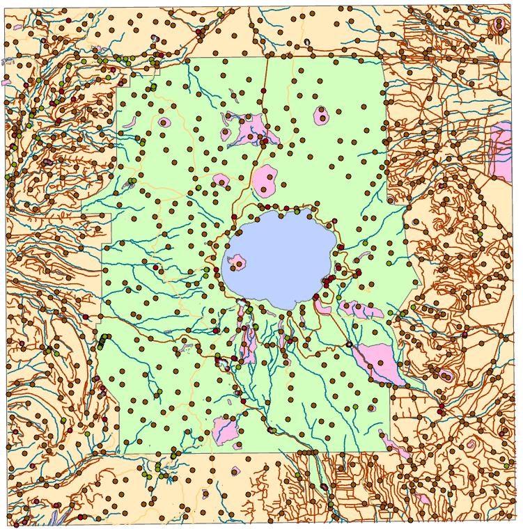
3 Crater Lake online map From NPS:
4 Download Crater Lake map packages here: ArcGIS Pro project packages: - Before edits were made: After edits were made: -
5 Hillshade, Terrain Living Atlas Data, Styles Hillshade - Turn on the layer Terrain - Add Terrain from the Living Atlas - On the Appearance tab, click DRA - In the Catalog pane, right-click Styles and click Add - Point out the NPS and Hypsometry styles - Select the Crater Lake style and click OK to add the Crater Lake style to the project - In the Catalog pane, right-click the style and click Manage to show the contents of the style - Note the point symbols - On the ribbon at top, click Show and scroll down to select Color scheme - Close the Catalog view - Change the symbology of the Terrain layer to use Crater Lake Hillshade
6 Lake Bathymetry Raster Functions, Edit a color scheme, Transparency in a color scheme Turn on the layer On the Analysis tab Raster Function Hillshade - Raster: bathy_lake - Hillshade Type: Multidirectional - Show and explain Scaling Adjusted - Create New Layer Change the color scheme to use 50% gray instead of black Move Bathy_lake above hillshade Apply the Bathymetry color scheme to the layer Edit the color scheme so that the light blue color is 40% transparent and the middle blue is 30% transparent
7 Area Not in Park Transparency Turn on the layer Change symbology to white solid fill and uncheck solid Set the transparency to 40%
8 Park Boundary Gradient fill Turn on the layer Change the symbology - In the Contents pane, click the symbol - In the Symbology pane, click the symbol and at the top, click Properties to see the Properties pane - Uncheck Solid stroke - Click the Layers button - Set Solid fill to Gradient fill - Set the first color to Peacock Green - Set the second color to No Color - Click Pattern - Interval = 15 - Extent = Absolute - Size= 15 - Click Apply
9 Set Reference Scale Reference scale, Bookmarks Right-click Map On the General tab, for reference scale, type Click OK Zoom in to see the effect Use the Zoomed Extent bookmark

10 Physiographic Polys Definition Query Turn on the layer Note that some polys are outside the park - Open the attribute table - Sort on the NPS Map field - Close the attribute table Set Def Query on physiog_polys Click OK
11 Label Physiographic Polygons Labels, Group panes to get tabs Right-click the layer and click Label to turn on labeling for physiog_polys Right-click the layer and click Labeling Properties - Click the Symbol tab - Text case = Upper case - Click the Position tab - 1st button (Placement): in polygon - 3 rd button (Conflict resolution): Remove duplicate labels note what happens for Spagnum Bog - Move the Label Class pane to tabs on the bottom of the Symbology tab On the Symbology pane - Uncheck Solid stroke and Solid fill - Click Apply
12 Lake Polys Turn on the layer Use the Details bookmark Change symbology - Change Width to Set Solid stroke color to Cretan Blue - Set Solid fill color to Crater Lake lakes in the Crater Lake style Set a Def Query so that Crater Lake is not covered up
13 Label Lake Polys Label Font Styles, Italics Turn on labels - On the Labeling tab a the top: - Symbol = Water Small - Color = Cretan Blue - Font Style = Italic
14 Crater Lake Copy layer, Update Def Query Copy and paste lake_polys Name it Crater Lake Edit Def Query so Name is equal to Crater Lake and Update Click the symbol Uncheck Solid Fill and click Apply On the Labeling tab: - Font Style = Bold Italic - Size = 14
15 Stream Lines Turn on the layer Change symbology - Color = Cretan blue - Line width = 0.5 Click Apply
16 Trail Lines Remove legend items Turn on the layer Open the attribute table to see the Symbol field Close the attribute table Change the symbology Unique Values - On the Primary symbology tab: - No symbol right-click and click Remove - Trails Gallery Dashed 4:4 Properties 1.0 pt Apply - Click the Back button - Pacific Crest Trail Gallery Dashed 6:6 Properties Peacock Green 2.0 pt Apply
17 Road Lines Uncheck Show all items, Format all symbols Turn on the layer Explain that there is Symbol attribute as for streams Change symbology Unique Values - On the Primary symbology tab: - Not shown right-click and click Remove - Click More uncheck Show all other values - Click More click Format all symbols - Gallery Highway Properties 3 pt Apply - Click the Back button - Minor Roads Properties White Apply
18 Road Lines Symbol Levels Click the Set Symbol Levels button - Click Enable symbol level drawing - Change Minor Roads to Join and Merge
19 Survey Points Label with an expression Turn on the layer Set Def Query so that NPS_map is Equal to Yes: Click the symbol Gallery Survey point in the Crater Lake style Right-click the layer click Label Right-click the layer click Labeling Properties - Language: VBScript don t forget this! - Click Import - Survey_Points.lpx - Verify - Apply
20 Cultural Points (symbolized) Pause drawing, NPS symbols ( Turn on the layer Show the symbology Unique Values CFT_desc Click More Show all other values has been unchecked Pause drawing Click Boat Landing symbol show point symbols in Gallery in the NPS style Explain that they were selected for the categories of symbols
21 Hydro Points Def Query with an expression, Vary symbols by attribute Turn on the layer Set a Def Query using the Hydro_Points expression Explain that I already assigned the symbols because I already showed them how to do that Symbology - Click More uncheck Show all other values - Select symbols - Click Vary symbology by attribute - Expand the Rotation - Field = angle - Rotation Style = Geographic
22 Cultural Polys Text formatting tags Turn on the layer Change the symbology - Properties uncheck Solid Stroke uncheck Solid fill Right-click the layer and click Labeling Properties - Import the Cultural_polys.lpx expression - Verify - Apply
23 Create Layout New Layout, Guides Insert new layout Size = Architectural C Set Guides Right-click margin to add guides at 0.0, 0.5 and 1.0 inches
24 Layout graphics and title Add Rectangle to top of map - Click Format tab - Change Fill to Black - Copy and paste rectangle and move the copy to the bottom and resize it Add title - Click Insert tab - Change Symbol to Title Large - Click Text - Click on map - Type Crater Lake National Park
25 Final Layout Insert map frame, map scale, activate map frame Close Symbology pane Open the Layout view On the Layout tab, click Navigate zoom into the layout On the Insert tab, click Map Frame Drag upper left to top left corner below black box and at edge of page Drag lower right to bottom left corner above black box and at edge of page At bottom of window, change map scale to On the Layout tab, in the Map group, click Activate Move the map so that the lower left extension is at the 0.5 guide Click the Layout tab and click Close Activation

26 North Arrow Add north arrow, add single guide On the Layout tab, click Navigate and zoom to upper left corner On the ruler, insert a guide at 22.5 On the Insert tab, click North Arrow Right-click the arrow and click Properties Set the height to 1 Move it up so it snaps to the 22.5 guide Close the Format Arrow pane


27 Scale bar Insert scale bar, Zoom to full view On the Layout tab, click Navigate and zoom to lower left corner At the bottom, in the middle, select Alternating Scale Bar 1 Snap it to the guides: In the Format Scale Bar pane, change divisions to 5 On the Layout tab, click Full Extent:
 - Hydro points Right-click the legend and click Properties Under Sizing, change Patch Width to 50 and Patch height to 30: Click Redraw On the Layout tab, click Navigate and")
28 Legend =Insert a legend, Work with legend items On the Insert tab, click Legend Draw a box in the upper right in the Drawing Order pane, expand the legend and uncheck all boxes except: - Cultural Point (symbolized) - Hydro points Right-click the legend and click Properties Under Sizing, change Patch Width to 50 and Patch height to 30: Click Redraw On the Layout tab, click Navigate and navigate to the full extent


29 Please Take Our Survey on the App Download the Esri Events app and find your event Select the session you attended Scroll down to find the feedback section Complete answers and select Submit


30
USING DATA DRIVEN PAGES
 USING DATA DRIVEN PAGES Mid-West ESRI Utility User s Group Conference March 26, 2014 Presented by: Hillary Bjorstrom, GIS Analyst STAR Energy Services LLC Alexandria, Minnesota EXERCISE 1 CREATING A GRID
City of La Crosse Online Mapping Website Help Document
 City of La Crosse Online Mapping Website Help Document This document was created to assist in using the new City of La Crosse online mapping sites. When the website is first opened, a map showing the City
Creating a Flyer. Open Microsoft Publisher. You will see the list of Popular Publication Types. Click the Blank Page Sizes.
 Creating a Flyer Open Microsoft Publisher. You will see the list of Popular Publication Types. Click the Blank Page Sizes. Double click on Letter (Portrait) 8.56 x 11 to open up a Blank Page. Go to File
Getting Started with GIS using ArcGIS 10.6 What is GIS? and - Module 1 Creating a map document
 Getting Started with GIS using ArcGIS 10.6 What is GIS? and - Module 1 Creating a map document Marcel Fortin Map & Data Library mdl@library.utoronto.ca 2018 http://mdl.library.utoronto.ca This workshop
Getting to Know ArcGIS Pro
 Getting to Know ArcGIS Pro SUPPLEMENT FOR ARCGIS PRO 2.2 Getting to Know ArcGIS Pro, first edition, published in 2016, was written and tested on ArcGIS Pro 1.1. Since then, the capabilities and user interface
Geographical Information Systems Institute. Center for Geographic Analysis, Harvard University. LAB EXERCISE 1: Basic Mapping in ArcMap
 Harvard University Introduction to ArcMap Geographical Information Systems Institute Center for Geographic Analysis, Harvard University LAB EXERCISE 1: Basic Mapping in ArcMap Individual files (lab instructions,
In this exercise, you will convert labels into geodatabase annotation so you can edit the text features.
 Instructions: Use the provided data stored in a USB. For the report: 1. Start a new word document. 2. Follow an exercise step as given below. 3. Describe what you did in that step in the word document
Chapter 5. Presenting Data
 Chapter 5. Presenting Data Copyright McGraw-Hill Education. Permission required for reproduction or display. 5-1 Map Design Process 5-2 1 About ArcGIS Chapter 5. Presenting Data 5-3 Page layouts and map
4. If you are prompted to enable hardware acceleration to improve performance, click
 Exercise 1a: Creating new points ArcGIS 10 Complexity: Beginner Data Requirement: ArcGIS Tutorial Data Setup About creating new points In this exercise, you will use an aerial photograph to create a new
Using GIS to Site Minimal Excavation Helicopter Landings
 Using GIS to Site Minimal Excavation Helicopter Landings The objective of this analysis is to develop a suitability map for aid in locating helicopter landings in mountainous terrain. The tutorial uses
Exercise 1: An Overview of ArcMap and ArcCatalog
 Exercise 1: An Overview of ArcMap and ArcCatalog Introduction: ArcGIS is an integrated collection of GIS software products for building a complete GIS. ArcGIS enables users to deploy GIS functionality
User Manual Version 1.1 January 2015
 User Manual Version 1.1 January 2015 - 2 / 112 - V1.1 Variegator... 7 Variegator Features... 7 1. Variable elements... 7 2. Static elements... 7 3. Element Manipulation... 7 4. Document Formats... 7 5.
Explore a map Learn ArcGIS
 Explore a map Learn ArcGIS In this lesson, you'll open a web map and learn how to navigate and work with it using map tools as you explore Farmer Markets in the Louisville Area. 1. Go to www.arcgis.com
Step by Step GIS. Section 1
 Step by Step GIS Section 1 Contact the web page given below for the data required to do the exercises (http://www.pasda.psu.edu/default.asp) Before beginning the tutorials please visit the Preparation
Introduction to GIS 2011
 Introduction to GIS 2011 Digital Elevation Models CREATING A TIN SURFACE FROM CONTOUR LINES 1. Start ArcCatalog from either Desktop or Start Menu. 2. In ArcCatalog, create a new folder dem under your c:\introgis_2011
ArcGIS Desktop: Fundamentals of Cartography
 ArcGIS Desktop: Fundamentals of Cartography Outline Symbology Style Files -.style Layer files -.lyr Labeling Label Classes Label Expressions Map Document files -.mxd Map Template files -.mxt Map Elements
Explore some of the new functionality in ArcMap 10
 Explore some of the new functionality in ArcMap 10 Scenario In this exercise, imagine you are a GIS analyst working for Old Dominion University. Construction will begin shortly on renovation of the new
Basic Mapping: Livelihood Zones In Haiti
 Basic Mapping: Livelihood Zones In Haiti - 2009 Barbara Parmenter, revised by Carolyn Talmadge 9/10/2017 for ArcMap 10.5.1 DATA SOURCES... 1 MAPPING NETWORK DRIVES OUTSIDE THE DATA LAB... 2 SETTING UP
Publisher 2016 Foundation. North American Edition SAMPLE
 Publisher 2016 Foundation Publisher 2016 Foundation North American Edition Microsoft Publisher 2016 Foundation - Page 2 2015 Cheltenham Group Pty. Ltd. All trademarks acknowledged. E&OE. No part of this
Getting Started with the NH Stone Wall Mapper January 2019
 Getting Started with the NH Stone Wall Mapper January 2019 Stone walls are significant cultural and historical features of the New England landscape. Creating a statewide inventory of existing stone walls
Activity: Using Mapbook
 Activity: Using Mapbook Requirements You must have ArcMap for this activity. Preparation: Download Mapbook. The download page is intimidating. Just scroll to the bottom and find the Download Now place.
Lesson 1: Creating, Formatting, and Editing a Word Document with a Picture Microsoft Word 2016 IN THIS CHAPTER, YOU WILL LEARN HOW TO
 Lesson 1: Creating, Formatting, and Editing a Word Document with a Picture Microsoft Word 2016 IN THIS CHAPTER, YOU WILL LEARN HOW TO Enter Text in a new document Enhance the Page with a border and Format
COGCC GIS Online Map Tools-Intranet Site July 12, 2011
 COGCC GIS Online Map Tools-Intranet Site July 12, 2011 Table of Contents Page Section Page Section 1 Introduction 7 Clear Selection 2 Double Click 7 Buffer 2 Arrow Tip Information 8 Select within 3 Busy
ArcGIS Pro Editing. Jennifer Cadkin & Phil Sanchez
 ArcGIS Pro Editing Jennifer Cadkin & Phil Sanchez ArcGIS Pro Editing Overview Provides tools that allow you to maintain, update, and create new data - Modifying geometry, drawing new features - Entering
Publisher 2016 Foundation SAMPLE
 Publisher 2016 Foundation Publisher 2016 Foundation Microsoft Publisher 2016 Foundation - Page 2 2015 Cheltenham Group Pty. Ltd. All trademarks acknowledged. E&OE. No part of this document may be copied
Activity 1 Utah. 1. Create a Word 1 folder in your Word folder on your student drive if you don t have one.
 Computer Technology Instructions Word 1 Activities 1-3 Activity 1 Utah 1. Create a Word 1 folder in your Word folder on your student drive if you don t have one. 2. Open the document Utah Text file from
GIS IN ECOLOGY: CREATING RESEARCH MAPS
 GIS IN ECOLOGY: CREATING RESEARCH MAPS Contents Introduction... 2 Elements of Cartography... 2 Course Data Sources... 3 Tasks... 3 Establishing the Map Document... 3 Laying Out the Map... 5 Exporting Your
Basic Mapping: Livelihood Zones In Haiti
 Basic Mapping: Livelihood Zones In Haiti - 2009 Barbara Parmenter, revised by Carolyn Talmadge 9/10/2016 DATA SOURCES... 1 MAPPING NETWORK DRIVES OUTSIDE THE DATA LAB... 2 SETTING UP YOUR ARCMAP SESSION...
Tutorial for Lane County Mapping Applications
 Tutorial for Lane County Mapping Applications Contents Overview... 2 Tools... 2 Navigation Tools... 3 Display Tools... 5 Information Tools... 6 Sharing Tools... 7 Common Tasks... 9 Identify or Show Data
You'll begin your map by signing in and navigating to your area of interest: Houston, Texas.
 Geoinformation and Sectoral Statistics Section (GiSS) Create a Webmap In this lesson, you'll create a map that shows hurricane evacuation routes in Houston, Texas. First, you'll begin a new map in ArcGIS
Overview of ArcGIS Online Applications. Champaign County
 Overview of ArcGIS Online Applications Champaign County Champaign County GIS Consortium Updated: April 2017 Table of Contents ArcGIS Online Application Overview... 3 Map Interface Symbology and Terminology...
User Guide. ExploreHRM ICT BIDS. 0 P a g e
 User Guide ICT BIDS 0 P a g e Contents Introduction... 2 Top Left Panel Navigation and Search Widgets... 3 Search... 3 Zoom In/Out... 3 Home... 3 Zoom Extent... 3 Right Panel Information and Print Widgets...
Visual Studies Exercise.Topic08 (Architectural Paleontology) Geographic Information Systems (GIS), Part I
 Geographic Information Systems (GIS), Part I") ARCH1291 Visual Studies II Week 8, Spring 2013 Assignment 7 GIS I Prof. Alihan Polat Visual Studies Exercise.Topic08 (Architectural Paleontology) Geographic Information Systems (GIS), Part I Medium: GIS
ARCH1291 Visual Studies II Week 8, Spring 2013 Assignment 7 GIS I Prof. Alihan Polat Visual Studies Exercise.Topic08 (Architectural Paleontology) Geographic Information Systems (GIS), Part I Medium: GIS
ArcGIS Pro Editing: An Introduction. Jennifer Cadkin & Phil Sanchez
 ArcGIS Pro Editing: An Introduction Jennifer Cadkin & Phil Sanchez See Us Here WORKSHOP ArcGIS Pro Editing: An Introduction LOCATION SDCC - Ballroom 20 D TIME FRAME Thursday 10:00 11:00 ArcGIS Pro: 3D
Designer Reference 1
 Designer Reference 1 Table of Contents USE OF THE DESIGNER...4 KEYBOARD SHORTCUTS...5 Shortcuts...5 Keyboard Hints...5 MENUS...7 File Menu...7 Edit Menu...8 Favorites Menu...9 Document Menu...10 Item Menu...12
Advanced Map Labeling using Maplex. Wendy Harrison & Samuel Troth
 Advanced Map Labeling using Maplex Wendy Harrison & Samuel Troth Presentation Overview We ll be using ArcGIS Pro Introduction - Different types of text in ArcGIS - role of the Maplex Label Engine labeling
Microsoft Publisher 2013 Foundation. Publisher 2013 Foundation SAMPLE
 Microsoft Publisher 2013 Foundation Publisher 2013 Foundation Microsoft Publisher 2013 Foundation - Page 2 2013 Cheltenham Group Pty. Ltd. All trademarks acknowledged. E&OE. No part of this document may
ArcGIS ArcMap and Cartography Part 3. Second Screen: Have a cool map open on the second screen and the Washington DC map (minimized).
.") ArcGIS ArcMap and Cartography Part 3 First slide on the screen as people walk in. Second Screen: Have a cool map open on the second screen and the Washington DC map (minimized). 1 Map Composition and Page
ArcGIS ArcMap and Cartography Part 3 First slide on the screen as people walk in. Second Screen: Have a cool map open on the second screen and the Washington DC map (minimized). 1 Map Composition and Page
Microsoft Powerpoint 2013
 Microsoft Powerpoint 2013 Lesson 4 Designing a Presentation 2014, John Wiley & Sons, Inc. Microsoft Official Academic Course, Microsoft Word 2013 1 Objectives 2014, John Wiley & Sons, Inc. Microsoft Official
Manitowoc County, WI Advanced Access GIS Viewer User Documentation
 Manitowoc County, WI Advanced Access GIS Viewer User Documentation Introduction Extensive time was put into developing this website both from a display, and from a printing and scaling perspective. This
LeeSpInS 2.0 Help Guide
 LeeSpInS 2.0 Help Guide http://leegis.leegov.com/leespins/ E-mail us at gis@leegov.com with any questions or issues using this site Navigation Tools Pan arrows scroll the map in the arrow direction or
Correcting Grammar as You Type. 1. Right-click the text marked with the blue, wavy underline. 2. Click the desired option on the shortcut menu.
 PROCEDURES LESSON 11: CHECKING SPELLING AND GRAMMAR Selecting Spelling and Grammar Options 2 Click Options 3 In the Word Options dialog box, click Proofing 4 Check options as necessary under the When correcting
Creating Your Own Map Hawaiian Volcanoes
 Professional Development Workshop on Integrating Geospatial Technology into the HS Classroom Activity 1: Creating Your Own Map Hawaiian Volcanoes In this activity, you'll start a new map and then add the
Correcting Grammar as You Type
 PROCEDURES LESSON 11: CHECKING SPELLING AND GRAMMAR Selecting Spelling and Grammar Options 2 Click Options 3 In the Word Options dialog box, click Proofing 4 Check options as necessary under the When correcting
Table of Contents. 1. Prepare Data for Input. CVEN 2012 Intro Geomatics Final Project Help Using ArcGIS
 Table of Contents 1. Prepare Data for Input... 1 2. ArcMap Preliminaries... 2 3. Adding the Point Data... 2 4. Set Map Units... 3 5. Styling Point Data: Symbology... 4 6. Styling Point Data: Labels...
Microsoft Office Excel
 Microsoft Office 2007 - Excel Help Click on the Microsoft Office Excel Help button in the top right corner. Type the desired word in the search box and then press the Enter key. Choose the desired topic
Session 7 MS Word. Graphics. Inserting Clipart, and Graphics Modify graphics Position graphics
 Session 7 MS Word Graphics Inserting Clipart, and Graphics Modify graphics Position graphics Table of Contents Session 7 Working with Graphics... 1 The Toolbar... 1 Drawing Toolbar... 1 Picture Toolbar...
To the GeoView System Overview Online Training Course
 Welcome! To the GeoView System Overview Online Training Course The Alberta Department of Energy provides GeoView as a mapping system to enable users to find geographic information in Alberta. GeoView retrieves
Microsoft Word Chapter 1. Creating, Formatting, and Editing a Word Document with Pictures
 Microsoft Word 2010 Chapter 1 Creating, Formatting, and Editing a Word Document with Pictures Objectives Enter text in a Word document Check spelling as you type Format paragraphs Format text Undo and
Publisher 2013 Foundation SAMPLE
 Publisher 2013 Foundation Publisher 2013 Foundation Microsoft Publisher 2013 Foundation - Page 2 2013 Cheltenham Group Pty. Ltd. All trademarks acknowledged. E&OE. No part of this document may be copied
PowerPoint Module 2: Modifying a Presentation
 1. In the Outline pane, a highlighted slide icon next to the slide number indicates that the slide is selected. True PowerPoint 26 LEARNING OBJECTIVES: BESK.OFIN.16.297 - Enter text in Outline view 2.
Esri Story Maps let you combine authoritative maps with narrative text, images, and multimedia
 Geoinformation and Sectoral Statistics Section (GiSS) Story Maps Esri Story Maps let you combine authoritative maps with narrative text, images, and multimedia content. They make it easy to harness the
Welcome to the Surface Water Data Viewer!
 1 Welcome to the Surface Water Data Viewer! The Surface Water Data Viewer is a mapping tool for the State of Wisconsin. It provides interactive web mapping tools for a variety of datasets, including chemistry,
Corel Ventura 8 Introduction
 Corel Ventura 8 Introduction Training Manual A! ANZAI 1998 Anzai! Inc. Corel Ventura 8 Introduction Table of Contents Section 1, Introduction...1 What Is Corel Ventura?...2 Course Objectives...3 How to
In order to follow this set of directions you will need the following
 How to Create Maps & Figures in ArcView 9x In order to follow this set of directions you will need the following 1) the Jenny s Louisiana GIS Instructional CD 2) a computer with ArcGIS on it (version 9.0
Lesson 8 : How to Create a Distance from a Water Layer
 Created By: Lane Carter Advisor: Paul Evangelista Date: July 2011 Software: ArcGIS 10 Lesson 8 : How to Create a Distance from a Water Layer Background This tutorial will cover the basic processes involved
Newaygo County Web Map
 Newaygo County Web Map Address/Parcel/Parcel Owner Search Map Overview Zoom Back to default extent Use your current location if allowable Widget Panel At the top of the map is a search function used for
Press the Plus + key to zoom in. Press the Minus - key to zoom out. Scroll the mouse wheel away from you to zoom in; towards you to zoom out.
 Navigate Around the Map Interactive maps provide many choices for displaying information, searching for more details, and moving around the map. Most navigation uses the mouse, but at times you may also
Creating a reference map
 Chapter 1 Creating a reference map Reference maps are basic, traditional maps. Their purpose is to illustrate geographic boundaries for cities, counties, and other areas. Reference maps have no underlying
InDesign Tools Overview
 InDesign Tools Overview REFERENCE If your palettes aren t visible you can activate them by selecting: Window > Tools Transform Color Tool Box A Use the selection tool to select, move, and resize objects.
Development Authority of the North Country (DANC) Internet Mapping Application Instructions Public Viewer 1. Purpose. 2. Logging-in. 3.
 Internet Mapping Application Instructions Public Viewer 1. Purpose. 2. Logging-in. 3.") Development Authority of the North Country (DANC) Internet Mapping Application Instructions Public Viewer 1. Purpose The purpose of this document is to outline basic functionality of the DANC Internet
Development Authority of the North Country (DANC) Internet Mapping Application Instructions Public Viewer 1. Purpose The purpose of this document is to outline basic functionality of the DANC Internet
Guide to Mapping Website (Public) December 2016 GC_236594
 December 2016 GC_236594") Guide to Mapping Website (Public) December 2016 GC_236594 Table of Contents Guide to Mapping Website (Public)... 1 December 2016... 1 Quick Start... 3 Map Layers... 4 How do I?... 5 Draw on the Map...
Guide to Mapping Website (Public) December 2016 GC_236594 Table of Contents Guide to Mapping Website (Public)... 1 December 2016... 1 Quick Start... 3 Map Layers... 4 How do I?... 5 Draw on the Map...
Map Viewer User Guide. January 2018
 January 2018 Revision History Map Viewer 3.0.1 Revision Date Author / Reviewer Description of Changes 1 April 6, 2017 RWE Addition of Known Issues, format changes. 2 April 11, 2017 RWE Revision for PROD
New Features Overview for My Memories Suite 9
 New Features Overview for My Memories Suite 9 New Project Types You can now choose from several new project options such as Posters, Metal Prints, Canvas Prints, Social Media templates, and Photo Gifts
Making Topographic Maps
 T O P O Applications N Making Topographic Maps M A P S Making Topographic Maps with TNTmips page 1 Before Getting Started TNTmips provides a variety of tools for working with map data and making topographic
13. Albums & Multi-Image Printing
 13. Albums & Multi-Image Printing The Album function is a flexible layout and printing tool that can be used in a number of ways: Two kinds of albums: At left we used automatic mode to print a collection
Lesson 2: Creating a Business Letter with a Letterhead and Table Microsoft Word 2016 IN THIS CHAPTER, YOU WILL LEARN HOW TO
 Lesson 2: Creating a Business Letter with a Letterhead and Table Microsoft Word 2016 IN THIS CHAPTER, YOU WILL LEARN HOW TO Change Margins Convert a hyperlink to regular text Insert and Format a Shape
How to...create a Video VBOX Gauge in Inkscape. So you want to create your own gauge? How about a transparent background for those text elements?
 BASIC GAUGE CREATION The Video VBox setup software is capable of using many different image formats for gauge backgrounds, static images, or logos, including Bitmaps, JPEGs, or PNG s. When the software
Lab 3: Digitizing in ArcGIS Pro
 Lab 3: Digitizing in ArcGIS Pro What You ll Learn: In this Lab you ll be introduced to basic digitizing techniques using ArcGIS Pro. You should read Chapter 4 in the GIS Fundamentals textbook before starting
Gloucester County Library System EXCEL 2007
 Gloucester County Library System EXCEL 2007 Introduction What is Excel? Microsoft E x c e l is an electronic s preadsheet program. I t is capable o f performing many diff e r e n t t y p e s o f c a l
Step by Step How to Manual
 www.quintewestmaps.com Step by Step How to Manual Click on to accept the disclaimer and go to the web GIS Step by Step Web Based GIS Interface Layout of Web Based GIS Save your Favorite Map Views Link
XnView Image Viewer. a ZOOMERS guide
 XnView Image Viewer a ZOOMERS guide Introduction...2 Browser Mode... 5 Image View Mode...14 Printing... 22 Image Editing...26 Configuration... 34 Note that this guide is for XnView version 1.8. The current
ArcGIS Basics: Mapping the US
 ArcGIS Basics: Mapping the US Revised February 15, 2010 Tufts University Author: Barbara Parmenter Introduction...1 Part 1 - Opening ArcMap and adding data layers...1 Part 2 Moving around the Map...4 Part
CVEN 2012 GEOMATICS LAB SPRING 2016 INTRO TO ESRI ARCGIS
 CVEN 2012 GEOMATICS LAB SPRING 2016 INTRO TO ESRI ARCGIS Objectives 1. Download and Add Data into ArcMap 2. Symbolize and Label Features 3. Navigate and Investigate the Map 4. Explore Attributes and Metadata
Managing Multiple Layouts in ArcGIS Pro
 Managing Multiple Layouts in ArcGIS Pro By Mike Price, Entrada/San Juan, Inc. What you will need ArcGIS Desktop with ArcMap 10.4 or higher and ArcGIS Pro 1.4 licenses ArcGIS Online for organizations account
XnView 1.9. a ZOOMERS guide. Introduction...2 Browser Mode... 5 Image View Mode...15 Printing Image Editing...28 Configuration...
 XnView 1.9 a ZOOMERS guide Introduction...2 Browser Mode... 5 Image View Mode...15 Printing... 22 Image Editing...28 Configuration... 36 Written by Chorlton Workshop for hsbp Introduction This is a guide
Introduction to GIS A Journey Through Gale Crater
 Introduction to GIS A Journey Through Gale Crater In this lab you will be learning how to use ArcMap, one of the most common commercial software packages for GIS (Geographic Information System). Throughout
Creating a Spreadsheet by Using Excel
 The Excel window...40 Viewing worksheets...41 Entering data...41 Change the cell data format...42 Select cells...42 Move or copy cells...43 Delete or clear cells...43 Enter a series...44 Find or replace
OrgPublisher Advanced Box Layout Editor
 OrgPublisher Advanced Box Layout Editor OrgPublisher Table of Contents Table of Contents... 3 Using the... 3 Arranging Chart Box Sections... 3 Sizing the Chart Box Section... 4 Moving, Deleting, or Resizing
Mid-West ESRI Utility User s Group Conference. March 26, 2014
 Mid-West ESRI Utility User s Group Conference March 26, 2014 Presented by: Hillary Bjorstrom, GIS Analyst STAR Energy Services LLC 1 What are Data Driven Pages? Data Driven Pages Workflow Creating an Index
Create a Scrolling Effect in PowerPoint 2007
 Create a Scrolling Effect in PowerPoint 2007 You have a large image, document, etc. that you d like to show in your presentation and you d like to be able to scroll through it with the ability to control
How to Make a Poster Using PowerPoint
 How to Make a Poster Using PowerPoint 1997 2010 Start PowerPoint: Make a New presentation a blank one. When asked for a Layout, choose a blank one one without anything even a title. Choose the Size of
Len Preston Chief, Labor Market Information New Jersey Department of Labor & Workforce Development
 Len Preston Chief, Labor Market Information New Jersey Department of Labor & Workforce Development Cooperative project of the State of New Jersey and the U.S. Bureau of the Census serving data users in
Creating a Strip Map Series
 Creating a Strip Map Series This exercise shows you how to make a series of maps along a linear feature. In this scenario, you will be making a series of maps along Dixie Highway starting at the Watterson
Microsoft Excel 2002 M O D U L E 2
 THE COMPLETE Excel 2002 M O D U L E 2 CompleteVISUAL TM Step-by-step Series Computer Training Manual www.computertrainingmanual.com Copyright Notice Copyright 2002 EBook Publishing. All rights reserved.
A QUICK TOUR OF ADOBE ILLUSTRATOR CC (2018 RELEASE)
") A QUICK TOUR OF ADOBE ILLUSTRATOR CC (2018 RELEASE) Lesson overview In this interactive demonstration of Adobe Illustrator CC (2018 release), you ll get an overview of the main features of the application.
A QUICK TOUR OF ADOBE ILLUSTRATOR CC (2018 RELEASE) Lesson overview In this interactive demonstration of Adobe Illustrator CC (2018 release), you ll get an overview of the main features of the application.
OnCOR Silverlight Viewer Guide
 Getting Around There are many ways to move around the map! The simplest option is to use your mouse in the map area. If you hold the left button down, then click and drag, you can pan the map to a new
Microsoft Office Word 2016 for Mac
 Microsoft Office Word 2016 for Mac Formatting Your Document University Information Technology Services Learning Technologies, Training & Audiovisual Outreach Copyright 2016 KSU Division of University Information
Exercise 1: Getting to know ArcGIS
 The Scenario You are working for the California Visitor s Commission. You have been asked to prepare a map of California for several dignitaries from out of the country. Your map will need to include enough
Add to the ArcMap layout the Census dataset which are located in your Census folder.
 Building Your Map To begin building your map, open ArcMap. Add to the ArcMap layout the Census dataset which are located in your Census folder. Right Click on the Labour_Occupation_Education shapefile
EnvSci360 Computer and Analytical Cartography
 EnvSci360 Computer and Analytical Cartography Lecture 5 Working with Type and Labels Key Points Labels are text that locate and identify features on a map Important for readability & communication EnvSci
Create a new document: Save your document regularly! The Big Picture: File>New
 Create a new document: File>New 1. On the menu bar, click File, then New. (Note: From now on, this will be indicated using the following notation style: File>New.) 2. Type in the dimensions for the publication
Introducing Gupta Report Builder
 Business Reporting Chapter 1 Introducing Gupta Report Builder You can use Report Builder to design reports. This chapter describes: Our approach to building reports. Some of the reports you can build.
Tutorial 2: Modifying the Data Displayed in ArcGIS
 Tutorial 2: Modifying the Data Displayed in ArcGIS For this tutorial, download the facilities listed in the Toxic Release Inventory from TOXMAP and the New Jersey county boundaries from the New Jersey
4 Timesaving Tips for Word 2010
 Teaching and Learning Center Table of Contents Page 1.0 Overview... 3 1.1 Before you begin... 3 2.0 Quick Styles... 4 2.1 Adding Heading 1 and Heading 2 Quick Styles... 5 3.0 Navigation Pane... 7 3.1 Using
HBS Training - IT Solutions. PlanWeb. Introduction
 HBS Training - IT Solutions PlanWeb Introduction CONTENTS Logging on to the system...3 The PlanWeb Window...5 The Tool Bar...6 The Status Bar...6 The Map Window...6 The Information Window...7 Changing
Geography 281 Map Making with GIS Project Six: Labeling Map Features
 Geography 281 Map Making with GIS Project Six: Labeling Map Features In this activity, you will explore techniques for adding text to maps. As discussed in lecture, there are two aspects to using text
ICAP - Intelligence Configuration for ArcGIS Pro. Natalie Feuerstein Dan Barnes Joe Bayles
 ICAP - Intelligence Configuration for ArcGIS Pro Natalie Feuerstein Dan Barnes Joe Bayles Overview Intelligence Analyst supporting Operations ArcGIS Pro SDK Intelligence Configuration for ArcGIS Pro -
Objectives. Objectives. Plan Ahead. Starting Excel 3/9/2010. Excel Chapter 3. Microsoft Office 2007
 Objectives Microsoft Office 2007 Excel Chapter 3 What-If Analysis, Charting, and Working with Large Worksheets Rotate text in a cell Create a series of month names Copy, paste, insert, and delete cells
All data is in Universal Transverse Mercator (UTM) Zone 6 projection, and WGS 84 datum.
 Zone 6 projection, and WGS 84 datum.") 111 Mulford Hall, College of Natural Resources, UC Berkeley (510) 643-4539 EXPLORING MOOREA DATA WITH QUANTUM GIS In this exercise, you will be using an open-source FREE GIS software, called Quantum GIS,
111 Mulford Hall, College of Natural Resources, UC Berkeley (510) 643-4539 EXPLORING MOOREA DATA WITH QUANTUM GIS In this exercise, you will be using an open-source FREE GIS software, called Quantum GIS,