1. Folder Structure, Terrain Feature Dataset, and Geodatabase Creation
|
|
|
- Randall Cain
- 6 years ago
- Views:
Transcription
1 1. Folder Structure, Terrain Feature Dataset, and Geodatabase Creation You will be working with a lot of different files and it is important to keep them organized so that is easy to place and locate things. The best way to keep track of data and your calculations is to have a folder for your project that contains a data folder. A. Create a folder with the following subfolders: I. Data i. Data Geodatabase ii. Results Geodatabase a. Terrain Feature Dataset with the following properties: 1. XY Coordinates: NAD 1983 State Plane VA South FIPS 4502 (US Feet)/your local State Plane system 2. Vertical Z Coordinates: NAVD 1988 (add _Feet to name) **It would be useful to save these to Coordinate Systems as favorites I. Documents II. Downloads III. Maps B. Set your projection as StatePlane Virginia FIPS South 4502 (US Feet)/your local State Plane system Folder Setup Data Data Results Documents Downloads Maps Terrain 2. Downloads A. Go to earthexplorer.usgs.gov/ B. Create an account and remain logged in C. Click on Dataset Tab
2 D. Scroll down to LIDAR>Expand>Check Toggle Coverage Map box E. Return to the Search Criteria tab F. Click the predefined area tab I. Select add shape i. Fill in: 1. State: Virginia 2. Area type: County 3. Area: Colonial Heights City ii. Click Add **You should see a red triangle highlighting options for Colonial Heights G. Click on the Results tab H. Look for the LIDAR Entity ID: I. VA_FEMA_MIDDLECOUNTIES_2011_ **This should be the second on the list II. Click on the foot to show the footprint **You will now see a highlighted tile of LIDAR Data for Colonial Heights III. Click on the icon with a green arrow point down labeled Download Options IV. A box will pop up and click download I. Save the download into the suggested Download folder that was created J. Once the download has finished go to the download and locate the zipped file I. Right click and extract all **The extraction should default to wherever the zip file is located Make an account on Earth Explorer Download correct LiDAR entity into specified folder 3. LAS Dataset A. Create new LAS Dataset by right clicking the Data folder > New > LAS Dataset I. Name the LAS Dataset II. Right click the created LAS Dataset > Properties
: NAD 1983 StatePlane Virginia South FIPS 4502 (US Feet) v.")
3 i. LAS Files Tab: Add Files > Navigate to Downloads folder ii. Surface Constraints Tab: Add Study_Area from Data.gdb > Set as Hard Clip iii. Statistics Tab: Calculate Statistics iv. XY Coordinate System Tab: Projected Coordinate Systems > StatePlane > NAD 1983 (US Feet): NAD 1983 StatePlane Virginia South FIPS 4502 (US Feet) v. Z Coordinate System Tab: Vertical Coordinate Systems > North America > Double Click NAD 1983 > Change Meter to Foot_US under linear unit vi. Click OK B. Customize LAS Dataset Toolbar I. Click Customize > Toolbars > LAS Dataset II. Dock the LAS Dataset Toolbar III. Right click the Dataset and go to Properties i. Display > Change point limit value to 5,000,000 ii. Change point density to Fine iii. Check Use scale to control full resolution **Full resolution scale: 5,000 iv. Check Always display LAS file extents v. Click Ok Create new LAS Dataset with proper items Dock LAS Dataset Change LAS Toolbar settings
 (Tool) i.")
 v.")

4 4. Pointclouds and Terrains A. Create new Pointcloud I. Search LAS to Multipoint using the Search tool and select LAS to Multipoint (3D Analyst) (Tool) i. Input: LAS File(s) ii. Output Feature Class: Terrain feature dataset > Name Pointclouddem iii. Average Point Spacing: 1.5 iv. Input Class Code: 2 (Ground) v. Coordinate System: Local StatePlane Coordinate System B. Create new Terrain I. Right click on Terrain feature dataset in Results.gdb > New > Terrain i. Name: pointclouddemterrain ii. Check pointclouddem and Study_Area iii. Approximate Point Spacing: 1.5 iv. Change Study_Area to Hard Clip v. Calculate Pyramid Properties vi. Finish and Build > Bring into Table of Contents
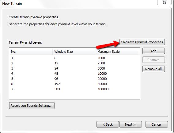
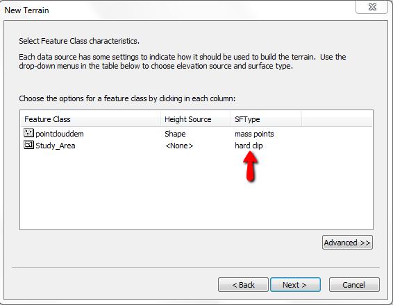
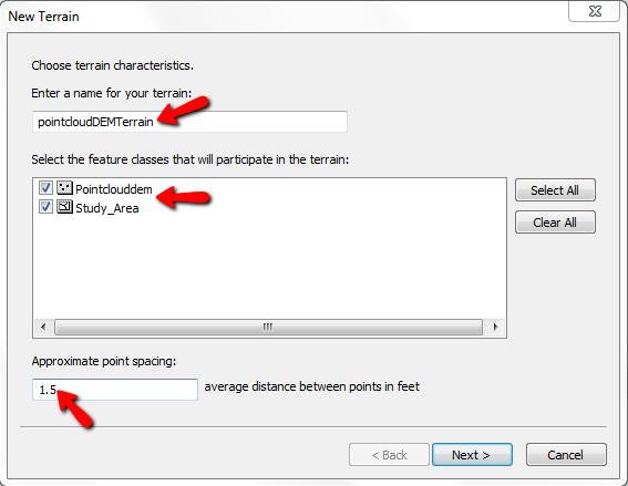
5 Create Pointcloud Create Terrain
MODULE 1 BASIC LIDAR TECHNIQUES
 MODULE SCENARIO One of the first tasks a geographic information systems (GIS) department using lidar data should perform is to check the quality of the data delivered by the data provider. The department
Lidar and GIS: Applications and Examples. Dan Hedges Clayton Crawford
 Lidar and GIS: Applications and Examples Dan Hedges Clayton Crawford Outline Data structures, tools, and workflows Assessing lidar point coverage and sample density Creating raster DEMs and DSMs Data area
Converting Lidar Data to Shapefile and Raster File Format for Analysis and Viewing
 Converting Lidar Data to Shapefile and Raster File Format for Analysis and Viewing 1. Create a File Based Geodatabase Open ArcCatolog and right click under contents and click New and File Geodatabase where
The ArcMap Interface and Using Basic ArcMap Analysis Tools to Create a Map
 The ArcMap Interface and Using Basic ArcMap Analysis Tools to Create a Map *You will need a computer with ESRI ArcGIS Desktop version 9.3 or higher installed* Data Download 1. Save the zipped folder with
George Mason University Department of Civil, Environmental and Infrastructure Engineering
 George Mason University Department of Civil, Environmental and Infrastructure Engineering Dr. Celso Ferreira Prepared by Lora Baumgartner December 2015 Revised by Brian Ross July 2016 Exercise Topic: GIS
GPS TO GIS EXERCISE (30 PTS)
") GPS TO GIS EXERCISE (30 PTS) This exercise will allow you to demonstrate your cumulative knowledge of using a GPS receiver to collect data with locational information, downloading this data to a desktop
GPS TO GIS EXERCISE (30 PTS) This exercise will allow you to demonstrate your cumulative knowledge of using a GPS receiver to collect data with locational information, downloading this data to a desktop
This Reporting Fragment will be sown on the Business Entity Details screen within OpenPages.
 Add a Reporting Fragment to an Object This KB article was written on the back of creating a reporting fragment and associating it to an object on a Windows 64bit install of OpenPages 6.0.1. Prior to adding
In order to follow this set of directions you will need the following
 How to Create Maps & Figures in ArcView 9x In order to follow this set of directions you will need the following 1) the Jenny s Louisiana GIS Instructional CD 2) a computer with ArcGIS on it (version 9.0
Creating Contours using ArcMap
 Creating Contours with ArcMap and ArcScene Digital elevation models (DEMs) are geospatial datasets that contain elevation values sampled according to a regularly spaced rectangular grid. They can be used
Google Earth II: Create a tour with Google Earth
 Google Earth II: Create a tour with Google Earth This workshop is a continuation of The Google Earth Workshop I: Map-making Basics. You will create a tour to show the main and satellite campuses of the
Initial Analysis of Natural and Anthropogenic Adjustments in the Lower Mississippi River since 1880
 Richard Knox CE 394K Fall 2011 Initial Analysis of Natural and Anthropogenic Adjustments in the Lower Mississippi River since 1880 Objective: The objective of this term project is to use ArcGIS to evaluate
Making a Sackville Coastal Flood Map
 Making a Sackville Coastal Flood Map Demo covers: Accessing and previewing map templates Modifying map elements such as titles, data frames, legends & scale bars Drawing a graphic on a map Adding text
RAPIDMAP Geocortex HTML5 Viewer Manual
 RAPIDMAP Geocortex HTML5 Viewer Manual This site was developed using the evolving HTML5 web standard and should work in most modern browsers including IE, Safari, Chrome and Firefox. Even though it was
Full Search Map Tab. This map is the result of selecting the Map tab within Full Search.
 Full Search Map Tab This map is the result of selecting the Map tab within Full Search. This map can be used when defining your parameters starting from a Full Search. Once you have entered your desired
GY461 GIS 1: Environmental Campus Topography Project with ArcGIS 9.x
 I. Introduction GY461 GIS 1: Environmental In this project you will use data from a topographic survey of the USA campus to generate 2 separate maps: 1. A color-coded 2-dimensional topographic contour
START>PROGRAMS>ARCGIS>
 Department of Urban Studies and Planning Spring 2006 Department of Architecture Site and Urban Systems Planning 11.304J / 4.255J GIS EXERCISE 2 Objectives: To generate the following maps using ArcGIS Software:
Step Sheet: Creating a PowerPoint Presentation
 Step Sheet: Creating a PowerPoint Presentation PowerPoint Presentation This step sheet will help you create a Microsoft PowerPoint presentation. Using Microsoft PowerPoint To create a presentation, follow
Mn/DOT MnCMAT Crash Analysis Application Help
 Mn/DOT MnCMAT Crash Analysis Application Contents Login... 5 User Login Dialog... 5 Login... 5 Request Access Dialog... 5 Forgotten Password Dialog... 6 Create/Open Project... 7 Create/Open Project Dialog...
Getting Started With LP360
 Getting Started With LP360 12/22/2015 1 Contents What is LP360?... 3 System Requirements... 3 Installing LP360... 4 How to Enable the LP360 Extension... 4 How to Display the LP360 Toolbar... 4 How to Import
Activity: Exploring GeoPDFs
 Activity: Exploring GeoPDFs A GeoPDF is a map stored in Adobe s Portable Document Format that is geographically referenced to a real world coordinate system. TerraGo Technologies, which is the company
Using LIDAR to Design Embankments in ArcGIS. Written by Scott Ralston U.S. Fish & Wildlife Service Windom Wetland Management District
 Using LIDAR to Design Embankments in ArcGIS Written by Scott Ralston U.S. Fish & Wildlife Service Windom Wetland Management District This tutorial covers the basics of how to design a dike, embankment
Geographical Information Systems Institute. Center for Geographic Analysis, Harvard University. LAB EXERCISE 1: Basic Mapping in ArcMap
 Harvard University Introduction to ArcMap Geographical Information Systems Institute Center for Geographic Analysis, Harvard University LAB EXERCISE 1: Basic Mapping in ArcMap Individual files (lab instructions,
Pleiades 1A data DEM extraction and DSM to DTM conversion Geomatica 2015 Tutorial
 Pleiades 1A data DEM extraction and DSM to DTM conversion Geomatica 2015 Tutorial A great innovation of the Pleiades system is to offer high resolution stereoscopic coverage capability. The stereoscopic
Files Used in this Tutorial
 Generate Point Clouds and DSM Tutorial This tutorial shows how to generate point clouds and a digital surface model (DSM) from IKONOS satellite stereo imagery. You will view the resulting point clouds
1. AUTO CORRECT. To auto correct a text in MS Word the text manipulation includes following step.
 1. AUTO CORRECT - To auto correct a text in MS Word the text manipulation includes following step. - STEP 1: Click on office button STEP 2:- Select the word option button in the list. STEP 3:- In the word
Tutorial 1: Downloading elevation data
 Tutorial 1: Downloading elevation data Objectives In this exercise you will learn how to acquire elevation data from the website OpenTopography.org, project the dataset into a UTM coordinate system, and
Basics of Using LiDAR Data
 Conservation Applications of LiDAR Basics of Using LiDAR Data Exercise #2: Raster Processing 2013 Joel Nelson, University of Minnesota Department of Soil, Water, and Climate This exercise was developed
In this lab, you will create two maps. One map will show two different projections of the same data.
 Projection Exercise Part 2 of 1.963 Lab for 9/27/04 Introduction In this exercise, you will work with projections, by re-projecting a grid dataset from one projection into another. You will create a map
Surrey City Centre Digital 3D Building Model
 Surrey City Centre Digital 3D Building Model Process Adding to the Existing City Centre Digital 3D Model Developer submits either a CAD or Sketchup digital 3D building model Includes 3D shapefile and Personal
City of La Crosse Online Mapping Website Help Document
 City of La Crosse Online Mapping Website Help Document This document was created to assist in using the new City of La Crosse online mapping sites. When the website is first opened, a map showing the City
Efficient Geocoding with ArcGIS Pro
 What you will need: An ArcGIS Online for organizations account ArcGIS Pro Efficient Geocoding with ArcGIS Pro By Mike Price, Entrada/San Juan, Inc. Public safety organizations rely on reliable, repeatable
Objectives Learn how to work with projections in GMS, and how to combine data from different coordinate systems into the same GMS project.
 v. 10.4 GMS 10.4 Tutorial Working with map projections in GMS Objectives Learn how to work with projections in GMS, and how to combine data from different coordinate systems into the same GMS project.
How to Access Remote Sensing Data Using EarthExplorer
 How to Access Remote Sensing Data Using EarthExplorer https://earthexplorer.usgs.gov/ EarthExplorer is the most-used tool to access remote sensing data at the (USGS) Earth Resources Observation and Science
GIS Workshop Spring 2016
 1/ 14 GIS Geographic Information System. An integrated collection of computer software and data used to view and manage information about geographic places, analyze spatial relationships, and model spatial
Creating raster DEMs and DSMs from large lidar point collections. Summary. Coming up with a plan. Using the Point To Raster geoprocessing tool
 Page 1 of 5 Creating raster DEMs and DSMs from large lidar point collections ArcGIS 10 Summary Raster, or gridded, elevation models are one of the most common GIS data types. They can be used in many ways
Esri International User Conference. July San Diego Convention Center. Lidar Solutions. Clayton Crawford
 Esri International User Conference July 23 27 San Diego Convention Center Lidar Solutions Clayton Crawford Outline Data structures, tools, and workflows Assessing lidar point coverage and sample density
v Working with Rasters SMS 12.1 Tutorial Requirements Raster Module Map Module Mesh Module Time minutes Prerequisites Overview Tutorial
 v. 12.1 SMS 12.1 Tutorial Objectives This tutorial teaches how to import a Raster, view elevations at individual points, change display options for multiple views of the data, show the 2D profile plots,
PurVIEW. for ESRI ArcGIS 9 AT A GLANCE. PurVIEW Toolbar. Stereoscopic image model display with geodatabase objects superimposed.
 PurVIEW Toolbar AT A GLANCE Stereoscopic image model display with geodatabase objects superimposed. Real-time XYZ coordinate 2 Installing the software Prerequisites: Must have the English version of Windows
Select Objects for Use
 System In TNTgis you select geospatial data for viewing and analysis using the Select objects window (which may have varying names depending on the context). The upper part of the window has several tabbed
COMMISSION OF TEXAS MAY
 GIS Viewer RAILROAD COMMISSION OF TEXAS MAY 2017 Table of Contents GIS Viewer Basics... 1 Basics... 1 Screen Overview... 2 Tools... 5 Visibility... 5 Measure Tool... 7 Identify Tool... 10 Coordinates Tool...
Intro to GIS (requirements: basic Windows computer skills and a flash drive)
") Introduction to GIS Intro to GIS (requirements: basic Windows computer skills and a flash drive) Part 1. What is GIS. 1. System: hardware (computers, devices), software (proprietary or free), people. 2.
Introduction to GIS Intro to GIS (requirements: basic Windows computer skills and a flash drive) Part 1. What is GIS. 1. System: hardware (computers, devices), software (proprietary or free), people. 2.
Tutorial for Lane County Mapping Applications
 Tutorial for Lane County Mapping Applications Contents Overview... 2 Tools... 2 Navigation Tools... 3 Display Tools... 5 Information Tools... 6 Sharing Tools... 7 Common Tasks... 9 Identify or Show Data
INTRODUCTION TO GIS WORKSHOP EXERCISE
 111 Mulford Hall, College of Natural Resources, UC Berkeley (510) 643-4539 INTRODUCTION TO GIS WORKSHOP EXERCISE This exercise is a survey of some GIS and spatial analysis tools for ecological and natural
button in the lower-left corner of the panel if you have further questions throughout this tutorial.
 Mosaic Tutorial: Simple Workflow This tutorial demonstrates how to use the Seamless Mosaic tool to mosaic six overlapping digital aerial scenes. You will learn about displaying footprints and image data
- Hold down the 'Shift' key and click and drag the mouse to create a red box which will zoom to that area when released.
 Basic navigation and zoom: To Pan around the map: - Click anywhere on the map and hold the button down until 4 directional arrows appear which will then allow the mouse to be moved in any direction panning
Tutorial 17: Desert City Tutorial
 Tutorial 17: Desert City Tutorial Table of Contents Tutorial 17: Desert city........................................... 3 2 Tutorial 17: Desert city Download items Tutorial data Tutorial PDF Prerequisites
Lidar Working with LAS Datasets
 2013 Esri International User Conference July 8 12, 2013 San Diego, California Technical Workshop Lidar Working with LAS Datasets Raghav Vemula (3D Team) Esri UC2013. Technical Workshop. Agenda Las Dataset
COPYRIGHTED MATERIAL. Introduction to 3D Data: Modeling with ArcGIS 3D Analyst and Google Earth CHAPTER 1
 CHAPTER 1 Introduction to 3D Data: Modeling with ArcGIS 3D Analyst and Google Earth Introduction to 3D Data is a self - study tutorial workbook that teaches you how to create data and maps with ESRI s
3D Analyst Visualization with ArcGlobe. Brady Hoak, ESRI DC
 3D Analyst Visualization with ArcGlobe Brady Hoak, ESRI DC 3D GIS Viewing geospatial data in 3D leads to new insights 2D 3D Sometimes you need to edit your data in 3D 2D 3D Some problems can only be solved
Microsoft Word - Templates
 Microsoft Word - Templates Templates & Styles. Microsoft Word come will a large amount of predefined templates designed for you to use, it is also possible to download additional templates from web sites
Activity: Using Mapbook
 Activity: Using Mapbook Requirements You must have ArcMap for this activity. Preparation: Download Mapbook. The download page is intimidating. Just scroll to the bottom and find the Download Now place.
Working with Attributes
 Working with Attributes QGIS Tutorials and Tips Author Ujaval Gandhi http://www.spatialthoughts.com This work is licensed under a Creative Commons Attribution 4.0 International License. Working with Attributes
Integrating Sintelix and ANB. Learn how to access and explore Sintelix networks in IBM i2 Analyst s Notebook
 Integrating Sintelix and ANB Learn how to access and explore Sintelix networks in IBM i2 Analyst s Notebook 2 Integrating Sintelix and ANB By the end of this tutorial you will know how to: 1 2 3 Install
_Tutorials. Arcmap. Linking additional files outside from Geodata
 _Tutorials Arcmap Linking additional files outside from Geodata 2017 Sourcing the Data (Option 1): Extracting Data from Auckland Council GIS P1 First you want to get onto the Auckland Council GIS website
Introduction to GIS 2011
 Introduction to GIS 2011 Digital Elevation Models CREATING A TIN SURFACE FROM CONTOUR LINES 1. Start ArcCatalog from either Desktop or Start Menu. 2. In ArcCatalog, create a new folder dem under your c:\introgis_2011
3 AXIS STANDARD CAD. BobCAD-CAM Version 28 Training Workbook 3 Axis Standard CAD
 3 AXIS STANDARD CAD This tutorial explains how to create the CAD model for the Mill 3 Axis Standard demonstration file. The design process includes using the Shape Library and other wireframe functions
CRC Website and Online Book Materials Page 1 of 16
 Page 1 of 16 Appendix 2.3 Terrain Analysis with USGS DEMs OBJECTIVES The objectives of this exercise are to teach readers to: Calculate terrain attributes and create hillshade maps and contour maps. use,
1. Start ArcMap by going to the Start menu > All Programs > ArcGIS > ArcMap.
 Learning ArcGIS: Introduction to ArcMap 10.1 The Map Document Feature Manipulation Navigating ArcMap Map Documents, Layers, and Features Shapes, Location, and Attribute Data Symbology Zoom, Pan and Map
BDM Hyperion Workspace Basics
 BDM Hyperion Workspace Basics Contents of this Guide - Toolbars & Buttons Workspace User Interface 1 Standard Toolbar 3 Explore Toolbar 3 File extensions and icons 4 Folders 4 Browsing Folders 4 Root folder
Letter Assistant Word 2003 Setting up a New Letter DOC
 Letter Assistant Word 2003 Setting up a New Letter DOC QUICK DOC: Letter Assistant Word 2003 The type of letter(s) you will be sending will depend on where you go in Encompass. Our example will be if you
Using GIS to Site Minimal Excavation Helicopter Landings
 Using GIS to Site Minimal Excavation Helicopter Landings The objective of this analysis is to develop a suitability map for aid in locating helicopter landings in mountainous terrain. The tutorial uses
WILD 2400 ASSIGNMENT #1: GPS TUTORIAL*
 WILD 2400 ASSIGNMENT #1: GPS TUTORIAL* Overview: In this tutorial you will learn how to collect, download, and display data using a Garmin GPSMAP 64 unit, the DNRGPS Application, and Google Earth. For
v. 9.1 WMS 9.1 Tutorial Watershed Modeling HEC-1 Interface Learn how to setup a basic HEC-1 model using WMS
 v. 9.1 WMS 9.1 Tutorial Learn how to setup a basic HEC-1 model using WMS Objectives Build a basic HEC-1 model from scratch using a DEM, land use, and soil data. Compute the geometric and hydrologic parameters
OPTIONAL EXERCISE 2 Creating a Fusion Project Part B
 OPTIONAL EXERCISE 2 Creating a Fusion Project Part B Objective Last Updated: April, 2016 Version: Fusion 3.50 This exercise continues with the creation of a Fusion project. In the last exercise you: examined
A Second Look at DEM s
 A Second Look at DEM s Overview Detailed topographic data is available for the U.S. from several sources and in several formats. Perhaps the most readily available and easy to use is the National Elevation
Introduction to Google Earth Tutorial Haiti. 3/15/2011. Tufts GIS Center. Data Exploration
 Introduction to Google Earth Tutorial Haiti. 3/15/2011. Tufts GIS Center. Data Exploration 1. Open Google Earth 2. On the left you will see a navigation pane with 3 sections: Search, Places and Layers.
AgWorks, LLC 111 W. 76 th Street - Davenport, Iowa 52806
 Standard Operating Procedures for AgOS Mapping Revisions Date Author Description 08/23/2012 Sara Toliver Creation of document Understanding Icons Icon Definition Customer (Inactive) Customer (Active) Farm
Tutorial 4 - Attribute data in ArcGIS
 Tutorial 4 - Attribute data in ArcGIS COPY the Lab4 archive to your server folder and unpack it. The objectives of this tutorial include: Understand how ArcGIS stores and structures attribute data Learn
D1.5a Create Access Master Files
 D1.5a Create Access Master Files Step 1. Open the file in Audacity a) Double- click on the Audacity program icon. Wait for Audacity to fully load. Click ok to dismiss Welcome to Audacity screen if it pops
Managing Content with AutoCAD DesignCenter
 Managing Content with AutoCAD DesignCenter In This Chapter 14 This chapter introduces AutoCAD DesignCenter. You can now locate and organize drawing data and insert blocks, layers, external references,
EXERCISE 2: GETTING STARTED WITH FUSION
 Document Updated: May, 2010 Fusion v2.8 Introduction In this exercise, you ll be using the fully-prepared example data to explore the basics of FUSION. Prerequisites Successful completion of Exercise 1
ArcGIS Basics: Mapping the US
 ArcGIS Basics: Mapping the US Revised February 15, 2010 Tufts University Author: Barbara Parmenter Introduction...1 Part 1 - Opening ArcMap and adding data layers...1 Part 2 Moving around the Map...4 Part
Import, view, edit, convert, and digitize triangulated irregular networks
 v. 10.1 WMS 10.1 Tutorial Import, view, edit, convert, and digitize triangulated irregular networks Objectives Import survey data in an XYZ format. Digitize elevation points using contour imagery. Edit
PRODUCTIVITY TIPS USING OUTLOOK Washtenaw Community College
 PRODUCTIVITY TIPS USING OUTLOOK 2016 Washtenaw Community College August 23, 2018 TABLE OF CONTENTS Email Management... 3 1. Create a Rule:... 3 2. Add a Folder to Your Favorites... 3 To Show Folders in
Water Distribution System Modeling EPANET. Import an existing water distribution model and modify link and node parameters within WMS
 v. 10.1 WMS 10.1 Tutorial Water Distribution System Modeling EPANET Hydraulic Model Import an existing water distribution model and modify link and node parameters within WMS Objectives View an existing
دورة تدريبية عن تطبيقات برنامج ARC GIS
 دورة تدريبية عن تطبيقات برنامج ARC GIS مايو 2009 دورة تدريبيت عن تطبيقاث برنامج ARC GIS 2009 مايو Table of Contents Introduction... viii Module 1: Introduction to ArcGIS 9 Module Objectives... 1-1 ArcGIS
Introduction This document will explain how to use the quick and advanced search functions in Document Locator.
 Table of Contents Introduction...1 Processes...1 Quick Search...3 Searching Examples:...3 Advance Search...4 File Dates...5 Document Notes...7 User File Activity...7 Record Management...7 Search on Size...8
Server Usage & Third-Party Viewers
 Server Usage & Third-Party Viewers October 2016 HiPER LOOK Version 1.4.16.0 Copyright 2015 PIXIA Corp. All Rights Reserved. Table of Contents HiPER LOOK Server Introduction... 2 Google Earth... 2 Installation...2
Follow-Up on the Nueces River Groundwater Problem Uvalde Co. TX
 Follow-Up on the Nueces River Groundwater Problem Uvalde Co. TX Analysis by Ryan Kraft 12/4/2014 1 Problem Formulation A reduction in discharge was detected at a gauging station along a portion of the
Building 3D models with the horizons method
 ARC HYDRO GROUNDWATER TUTORIALS SUBSURFACE ANALYST Building 3D models with the horizons method Arc Hydro Groundwater (AHGW) is a geodatabase design for representing groundwater datasets within ArcGIS.
PWC County Mapper XM User Instruction (AS OF 12/03/2009)
") PWC County Mapper XM User Instruction (AS OF 12/03/2009) MAP NAVIGATION There are several ways to navigate the map, you can use your keyboard/mouse combination, use the Navigation toolbar, use the slider
PWC County Mapper XM User Instruction (AS OF 12/03/2009) MAP NAVIGATION There are several ways to navigate the map, you can use your keyboard/mouse combination, use the Navigation toolbar, use the slider
Visualizing Development
 I N T R O D U C T I O N Visualizing Development You will build something like this by the end of this tutorial This tutorial will be the final step in our downtown redevelopment endeavor. We will use a
Exercise 1: An Overview of ArcMap and ArcCatalog
 Exercise 1: An Overview of ArcMap and ArcCatalog Introduction: ArcGIS is an integrated collection of GIS software products for building a complete GIS. ArcGIS enables users to deploy GIS functionality
Step by Step GIS. Section 1
 Step by Step GIS Section 1 Contact the web page given below for the data required to do the exercises (http://www.pasda.psu.edu/default.asp) Before beginning the tutorials please visit the Preparation
Editing Parcel Fabrics Tutorial
 Editing Parcel Fabrics Tutorial Copyright 1995-2010 Esri All rights reserved. Table of Contents Tutorial: Getting started with parcel fabric editing...................... 3 Tutorial: Creating new parcels
Objectives Learn how to work with projections in WMS, and how to combine data from different coordinate systems into the same WMS project.
 s v. 11.0 Projections / Coordinate Systems WMS 11.0 Tutorial Projections / Coordinate Systems Working with map projections in WMS Objectives Learn how to work with projections in WMS, and how to combine
The Preparing for Success Online Mapping Tool
 The Preparing for Success Online Mapping Tool Baker Polito Administration The Executive Office of Housing and Economic Development and MassGIS Questions & Comments? Please contact MassWorks@state.ma.us
Combine Yield Data From Combine to Contour Map Ag Leader
 Combine Yield Data From Combine to Contour Map Ag Leader Exporting the Yield Data Using SMS Program 1. Data format On Hard Drive. 2. Start program SMS Basic. a. In the File menu choose Open. b. Click on
Geography 281 Mapmaking with GIS Project One: Exploring the ArcMap Environment
 Geography 281 Mapmaking with GIS Project One: Exploring the ArcMap Environment This activity is designed to introduce you to the Geography Lab and to the ArcMap software within the lab environment. Please
Excel 2013 Next Steps
 Excel 2013 Next Steps ADULT SERVICES DEPARTMENT CRYSTAL LAKE PUBLIC LIBRARY 126 W. PADDOCK STREET CRYSTAL LAKE, IL 60014 815-459-1687, X7 WWW.CLPL.ORG Agenda 2 Home Toolbar Alignment Group Number Formats
2) Make sure that the georeferencing extension is on by right-clicking in the task bar area and selecting Georeferencing
 Make sure that the georeferencing extension is on by right-clicking in the task bar area and selecting Georeferencing") HGIS Workshop Module 1 Georeferencing Large Scale Scanned Historical Maps Objective: Learn the Principles of Georeferencing 1) In ArcMap, open the project 01 data\arcdata_10_1\arcdata\toronto\georeference.mxd
HGIS Workshop Module 1 Georeferencing Large Scale Scanned Historical Maps Objective: Learn the Principles of Georeferencing 1) In ArcMap, open the project 01 data\arcdata_10_1\arcdata\toronto\georeference.mxd
TRAINING GUIDE. Lucity Webmap 2017r2
 TRAINING GUIDE Lucity Webmap 2017r2 Web Map The Lucity Web Map provides a way for users to see and work with their asset and work data. This allows them to see relationships between objects and plan work
Register in the Broker Portal. Table of Contents
 Register in the Broker Portal This guide is intended to show you how to register and prepare your broker profile in the Broker Portal. Table of Contents Register in the Broker Portal... 1 Personal Information...
Manitowoc County, WI Advanced Access GIS Viewer User Documentation
 Manitowoc County, WI Advanced Access GIS Viewer User Documentation Introduction Extensive time was put into developing this website both from a display, and from a printing and scaling perspective. This
Files Used in this Tutorial
 RPC Orthorectification Tutorial In this tutorial, you will use ground control points (GCPs), an orthorectified reference image, and a digital elevation model (DEM) to orthorectify an OrbView-3 scene that
Chapter 1 : Getting Started with Integrity... Chapter 2 : Interface Layout... Chapter 3 : Navigation... Chapter 4 : Printing...
 .0 User s Manual Table of Contents Chapter : Getting Started with Integrity... Chapter : Interface Layout... Chapter : Navigation... Chapter : Printing... Chapter : Quick Search and Results Pane... Results
WMS 9.1 Tutorial Watershed Modeling DEM Delineation Learn how to delineate a watershed using the hydrologic modeling wizard
 v. 9.1 WMS 9.1 Tutorial Learn how to delineate a watershed using the hydrologic modeling wizard Objectives Read a digital elevation model, compute flow directions, and delineate a watershed and sub-basins
WMS 8.4 Tutorial Hydraulics and Floodplain Modeling Simplified Dam Break Learn how to run a dam break simulation and delineate its floodplain
 v. 8.4 WMS 8.4 Tutorial Hydraulics and Floodplain Modeling Simplified Dam Break Learn how to run a dam break simulation and delineate its floodplain Objectives Setup a conceptual model of stream centerlines
ITEC185. Introduction to Digital Media SKETCHUP MAKE I
 ITEC185 Introduction to Digital Media SKETCHUP MAKE 2016 - I What is SketchUp? It s software that lets you use your computer to create models of objects and buildings in three dimensions. It's not hard
Learn how to delineate a watershed using the hydrologic modeling wizard
 v. 11.0 WMS 11.0 Tutorial Learn how to delineate a watershed using the hydrologic modeling wizard Objectives Import a digital elevation model, compute flow directions, and delineate a watershed and sub-basins