DSD GIS Viewer 2.0 DSD/ IIO
|
|
|
- Rose Peters
- 6 years ago
- Views:
Transcription


1 DSD GIS Viewer 2.0 DSD/ IIO

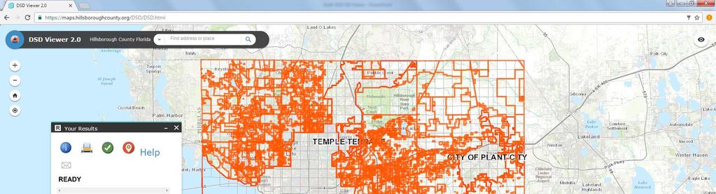
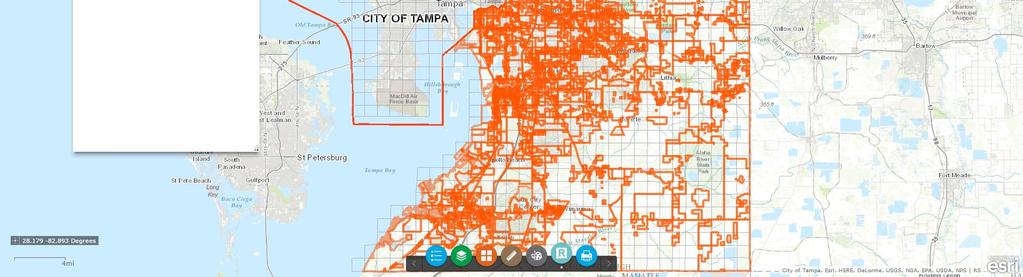
2 DSD Viewer II Below are instructions for using the viewer. The viewer can be found at The DSD Viewer provides regulatory and other information for selected parcels and allows the user to export the results to a PDF that can be printed or ed. Using the viewer Controls Shortcuts Click and drag the mouse to pan Mouse Scroll Forward to zoom in Mouse Scroll Backward to zoom out SHIFT + Drag the mouse to zoom in SHIFT + CTRL + Drag the mouse to zoom out SHIFT + Click to re-center Double Click to Center and Zoom in SHIFT + Double Click to Center and Zoom in Use arrow keys to pan Use + key to zoom in a level Use - key to zoom out a level Finding a Location Zoom in Button Zoom out Button Home Button Locations can be found by entering an address, intersections and by folio number. Zoom to Current Location Button Overview Map Button (shows inset small map of the location selected) Menu Ribbon Opens Legend Dialog Button Opens Layers List Button The address is entered as a single line in the "Find address or place" box in any format you choose. Intersections can be found by entering the two street names separated by "&" or "and". Folio numbers can be found by entering the number in the following format: xxx.xxxx. When a location is found by folio number the results report will be populated. Opens Basemap Gallery Button Opens Measure Button Opens Draw/Paint Button Opens Results Dialog Button Opens Print Dialog Button

3 Layer List Dialog Button Legend Dialog Button Provides layers available to use. Map layers can be turned on or off by clicking on the checkbox to the left of a layer name. Layer groups can be turned on or off by clicking on the layer group checkbox. Provides details for each of the selected layers.


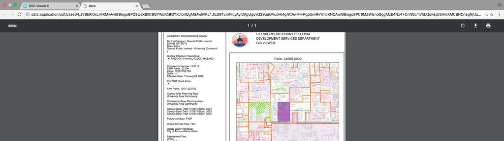
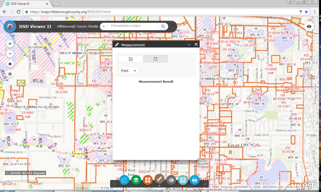
4 Basemap Dialog Button Provides different background maps available. To change the background map, click on one of the maps available and the background of viewer will change accordingly. Draw Dialog Button Provides options for map area drawing. Measure Dialog Button Provides options for calculating Area, Distance and Coordinates. To measure distance, select Area then click to set point A then click to select point B, Click once to add point C or double click to end the measurement. Result Dialog Button Provides parcel information details. Click on the parcel to query the details information and it loads the results window. Identifier Button: Click on this button then click on a parcel on the map to load the results window with the parcel information. The cursor will
5 turn into crosshairs to show that it is in select parcel mode. the output parameters. Create PDF Button: Clicking on this button will create a PDF with the results and a map that can be saved or ed (takes a while). Displaying the legend will add the legend to the PDF. This may not show if a popup blocker is active. Instructions to allow popups can be found here: Enable popups Clear All Button: Clicking on this button will remove the parcel highlight on the map, clear the parcel data in the dialog. Show Appraiser s Info Button: Clicking on this button will show the Property Appraiser Site information for the currently selected parcel. Show Help PDF Restore Previous Settings Appears when starting the application. This will restore previous layer settings and the last window when the application was last exited. Print Dialog Button Allows printing the map without the results text. This option provides multiple formats and sizes. It also allows you to add a title and change some of Map Popups Clicking on a feature on the map opens a popup for all of the layers that are visible and have a popup enabled. To scroll through the layer popups, click on the arrows on the top right.
6 Viewer Layers by Group HC Aviation Authority (4) Airport Height Restrictions Landfill Notification Area Not Compatible Use TEA Influence Area Turning layers on and off Nature (13) Flood Zones (Current) Flood Map 2008 Soils Map Eagles Nest (660 ft. buffer) Contours Surface Protection Areas Coastal Hi Hazard Areas 2006 ELLAP Significant Wildlife Areas Volume Sensitive Areas Peak Sensitive Areas Firm Panels Flood Zone Elevations Planning (5) Existing Land Use Future Land Use Community Planning Area Planning Areas Urban/Rural Service Areas Clicking on checkbox for group layer turns all sub-layers on and off. Individual sub-layers are turned on or off by clicking on the checkbox next to it. Zoning/Regulatory (6) Zoning Special Districts/Overlays DRIs Historical Resources/Parcels Plan Development Zoning Mosaic
7 Transportation (3) Roadway Classification Roadway Jurisdiction TAZs 2040 Impact Fees (5) Parcels No Address (plots faster) Road Names for Aerials (plots street names on aerial base maps) Fire Impact Fee Parks Impact Fee Residential Impact Fee Transportation Impact Fee Mobility Fee Benefit Districts Services (6) Fire Stations Library Parks Hospitals Schools Shelters Governance (5) Commission Districts Incorporated Subdivision Names Community Development Districts Census Tracks Utilities (7) Note: not available in public version Water Reclaimed Water Waste Water Storm Water Wells Water Service Area Waste Water Service Area Additional Layers: Parcels (shows address number) Show Folio Numbers
8
 Only use Google Chrome for the")

9 Info Print Clear Info Property Appraiser s Web link for the subject parcel Search bar (type folio; address or intersection) Only use Google Chrome for the DSD Viewer 2.0 Use this website Results box (brings all the information related to the parcel ) Layers of Info Aerials
10
11
12 NEW DSD VIEWER II: INFORMATION LAYERS BY GROUP HC Aviation Authority (4) Planning (5) Transportation (3) Services (6) Governance (5) Airport Heigh Restrictions Existing Land Use Roadway Classification Fire Stations Commission Districts Landfill nitification Future Land Use Roadway Jurisdiction Library Incorporated Not Compatible Use Community Planning Areas TAZs 2040 Parks Subdivision Names TEA Influence Area Planning Areas Hospitals Community Development Districts Urban /Rural Service Areas Schools Census Tracks Shelters Nature (13) Zoning/Regulatory (7) Impact Fees (4) Utilities (5) Flood Zones Zoning Fire Impact Fee Water Flood Map 2008 Special Districts/Overlays Parks Impact Fee Reclaimed Water Soils Map DRIs Residential Impact Fee Wastewater Eagles Nests (660 Buffer) Historical Resources/Parcels Transportation Impact Fee Stormwater Countours Plan Development Wells Surface Protection Areas Zoning_Mosaic Water Service Area Coastal Hi Hazard Areas 06 Zoning Historical Maps Mobility Fee (2) Wastewater Service Area ELLAP Benefit Districts Significant Wildlife Areas Assessment Districts Volume Sensitive Areas Peak Sensitive Areas Firm Panels Flood Zone Elevations DSD: 54 Information Layers as 11/03/2016
13
14
Peoria County Front Desk Map Application
 Peoria County Front Desk Map Application Quick Guide, 2017 At a First Glance This guide will tell users all they need to know about the Peoria County Front Desk application which can be found on the Peoria
This guide will tell you all you need to know about the new Front Desk application which can be found on the main Peoria County GIS website.
 New Front Desk Quick Guide, 2014 At a First Glance This guide will tell you all you need to know about the new Front Desk application which can be found on the main Peoria County GIS website. When you
Tutorial for Lane County Mapping Applications
 Tutorial for Lane County Mapping Applications Contents Overview... 2 Tools... 2 Navigation Tools... 3 Display Tools... 5 Information Tools... 6 Sharing Tools... 7 Common Tasks... 9 Identify or Show Data
City of La Crosse Online Mapping Website Help Document
 City of La Crosse Online Mapping Website Help Document This document was created to assist in using the new City of La Crosse online mapping sites. When the website is first opened, a map showing the City
COMMISSION OF TEXAS MAY
 GIS Viewer RAILROAD COMMISSION OF TEXAS MAY 2017 Table of Contents GIS Viewer Basics... 1 Basics... 1 Screen Overview... 2 Tools... 5 Visibility... 5 Measure Tool... 7 Identify Tool... 10 Coordinates Tool...
How to use the DuPage County Parcel Viewer Interactive Web Mapping Application.
 How to use the DuPage County Parcel Viewer Interactive Web Mapping Application. Parcel Viewer URL: URL: http://gis.dupageco.org/parcelviewer/ Initial View (And frequently asked questions) Parcel Search
- Hold down the 'Shift' key and click and drag the mouse to create a red box which will zoom to that area when released.
 Basic navigation and zoom: To Pan around the map: - Click anywhere on the map and hold the button down until 4 directional arrows appear which will then allow the mouse to be moved in any direction panning
Manitowoc County, WI Advanced Access GIS Viewer User Documentation
 Manitowoc County, WI Advanced Access GIS Viewer User Documentation Introduction Extensive time was put into developing this website both from a display, and from a printing and scaling perspective. This
Read and accept the following disclaimer:
 How to use the Person County Tax Parcel Viewer Visit gis.personcounty.net and click to view the Tax Parcel Viewer or go to gis.personcounty.net/taxparcelviewer Read and accept the following disclaimer:
SAGIS Property Map Viewer Instruction Manual Instructions for using the SAGIS Property Map Viewer. Published December 21, 2018.
 SAGIS Property Map Viewer Instruction Manual www.sagis.org/map Instructions for using the SAGIS Property Map Viewer. Published December 21, 2018. 1 Instructional Videos Click on a link to watch a video
Climate-Smart New Orleans
 Climate-Smart New Orleans Table of Contents GETTING THERE... 2 Accessing the site... 2 Logging into the site... 2 Navigating the Map... 2 Zoom & Pan... 2 Change the map background... 3 Interacting in the
User Guide. ExploreHRM ICT BIDS. 0 P a g e
 User Guide ICT BIDS 0 P a g e Contents Introduction... 2 Top Left Panel Navigation and Search Widgets... 3 Search... 3 Zoom In/Out... 3 Home... 3 Zoom Extent... 3 Right Panel Information and Print Widgets...
Guide to Mapping Website (Public) December 2016 GC_236594
 December 2016 GC_236594") Guide to Mapping Website (Public) December 2016 GC_236594 Table of Contents Guide to Mapping Website (Public)... 1 December 2016... 1 Quick Start... 3 Map Layers... 4 How do I?... 5 Draw on the Map...
Guide to Mapping Website (Public) December 2016 GC_236594 Table of Contents Guide to Mapping Website (Public)... 1 December 2016... 1 Quick Start... 3 Map Layers... 4 How do I?... 5 Draw on the Map...
Clicking this icon will open the Layer list and will look something like this:
 Webmap Tutorial Last updated: November 17, 2015 To Use the Web map: Open internet browser a. Type in the URL address: i. http://arkcity.maps.arcgis.com/apps/webappviewer/index.html?id=22e0751b74f3411685160c7
REDI 5.0 User Manual
 REDI 5.0 User Manual OBJECTIVE: REDI (Regional Economic Development Information System) provides a quick, convenient and easy way of accessing the City of San Diego Business Incentive Zones (BIZ) information.
And now the water system should be displayed:
 Webmap Tutorial Last updated: October 14, 2016 To Use the Web map: Open internet browser a. Type in the URL address: i. http://70.167.59.150/internal ii. Save in Favorites tab b. Note: This should work
OnCOR Silverlight Viewer Guide
 Getting Around There are many ways to move around the map! The simplest option is to use your mouse in the map area. If you hold the left button down, then click and drag, you can pan the map to a new
Getting Started with VicMap
 Getting Started with VicMap This is a brief overview of some of the tools and features available on VicMap. At any time you can right click on the map and click Identify What s Here to find more information
Juniata County, Pennsylvania
 GIS Parcel Viewer Web Mapping Application Functional Documentation June 21, 2017 Juniata County, Pennsylvania Presented by www.worldviewsolutions.com (804) 767-1870 (phone) (804) 545-0792 (fax) 115 South
A Guide to Using the Planning Office s Interactive Maps
 A Guide to Using the Planning Office s Interactive Maps This guide is intended to assist the user in using the maps provided on the County Planning Office website that are branded as Interactive Maps.
Parkland County s Public Interactive Mapping Application USER MANUAL
 Parkland County s Public Interactive Mapping Application USER MANUAL Geographic Information Systems Discover Parkland v3.0 Updated: January 2017 Table of Contents I. Welcome to v3.0... 3 II. Discover Parkland
St. Joseph County. GIS Department FetchGIS Web Map Tutorial
 St. Joseph County GIS Department FetchGIS Web Map Tutorial 2 Table of Contents Contents Slide #(s) Where to Find the Web Map 3 Disclaimer 4 Turning On and Off Map Layers 5 Searching for Parcels 6 More
Geocortex HTML 5 Viewer Manual
 Geocortex HTML 5 Viewer Manual Searching for a feature Use the Search Feature box in the top right hand corner of the viewer window. You can use this to search numerous data types such as property number,
LeeSpInS 2.0 Help Guide
 LeeSpInS 2.0 Help Guide http://leegis.leegov.com/leespins/ E-mail us at gis@leegov.com with any questions or issues using this site Navigation Tools Pan arrows scroll the map in the arrow direction or
P&D GIS Map How-To-Guide Thomas Fire / January 9, 2018 Debris Flow
 P&D GIS Map How-To-Guide The interactive GIS web-based map is available here. Once you have accessed the map, type in your address in the field on the top right corner and click on the magnifying glass
Vertisee Help Interface and Tools VERTISEE HELP. Interface and Tools. McElhanney Consulting Services Ltd Page 1
 VERTISEE HELP Interface and Tools McElhanney Consulting Services Ltd. 2016 Page 1 Contents Browser Interface... 3 Bookmark Tool... 4 Basemap... 5 Coordinate Display Tool... 6 Edit Tool... 7 Find Coordinates
Greater Bridgeport Regional Council Municipal GIS Viewer Training April 2015
 Greater Bridgeport Regional Council Municipal GIS Viewer Training April 2015 GBRC GIS Web Training Table of Contents Introduction........................................................... 3 Viewer Components.......................................................
Map Functions August 3, 2015 Triangle Homes Group
 Map Functions August 3, 2015 Triangle Homes Group Preston Neighborhoods and Property Map The Map is an interactive web based using ArcGIS Online by ESRI ESRI is the world s largest Geographic Information
Map Viewer User Guide. January 2018
 January 2018 Revision History Map Viewer 3.0.1 Revision Date Author / Reviewer Description of Changes 1 April 6, 2017 RWE Addition of Known Issues, format changes. 2 April 11, 2017 RWE Revision for PROD
RAPIDMAP Geocortex HTML5 Viewer Manual
 RAPIDMAP Geocortex HTML5 Viewer Manual This site was developed using the evolving HTML5 web standard and should work in most modern browsers including IE, Safari, Chrome and Firefox. Even though it was
GIS Basics for Urban Studies
 GIS Basics for Urban Studies Date: March 21, 2018 Contacts: Mehdi Aminipouri, Graduate Peer GIS Faciliator, SFU Library (maminipo@sfu.ca) Keshav Mukunda, GIS & Map Librarian Librarian for Geography (kmukunda@sfu.ca)
PUBLIC WORKS. 1oo. DiEital Fee Schedules. Effective January 1, 2008
 PUBLIC WORKS Geographic Information Systems DiEital Fee Schedules Effective January 1, 2008 Date Advertised 12103/07 In (Publication) Daily Business Journal Public Hearing Date Approved as to form: David
Town of Amherst, NY. GIS Map Machine User Guide. Map Window Search Functions. Help. Toolbar. Layer Control. Scale Bar
 Town of Amherst, NY GIS Map Machine User Guide Toolbar Map Window Search Functions Help Layer Control Scale Bar Map Window Main Elements The MAP WINDOW is the main focus of the screen and where the map
Frequently Asked Questions
 Frequently Asked Questions 1. General Questions: a. Why doesn t the map show correctly when I print it? b. There are too many layers on the map. How do I turn some of them off? c. Can I display more than
MainStreetMaps Web GIS User Guide
 MainStreetMaps Web GIS User Guide by MainStreetGIS, LLC www.mainstreetgis.com Updated 11/11/2017 Web GIS User Guide - Copyright MainStreetGIS, LLC - www.mainstreetgis.com Page 1 of 15 Table of Contents
Using Syracuse Community Geography s MapSyracuse
 Using Syracuse Community Geography s MapSyracuse MapSyracuse allows the user to create custom maps with the data provided by Syracuse Community Geography. Starting with the basic template provided, you
imaps v2 QUICKSTART GUIDE
 imaps v2 QUICKSTART GUIDE http://maps.raleighnc.gov/imaps/index.html Search for Condo Units new! You can now search for individual condo records when you search by address in the property search. Or, select
Overview of ArcGIS Online Applications. Champaign County
 Overview of ArcGIS Online Applications Champaign County Champaign County GIS Consortium Updated: April 2017 Table of Contents ArcGIS Online Application Overview... 3 Map Interface Symbology and Terminology...
USER S MANUAL. ArboWebForest. WebUI
 USER S MANUAL ArboWebForest WebUI i USER'S MANUAL TABLE OF CONTENTS Page # 1.0 GENERAL INFORMATION... 1-1 1.1 System Overview... 1-1 1.2 Organization of the Manual... 1-1 2.0 SYSTEM SUMMARY... 2-1 2.1
NEW LOOK OF RAPIDMAP! Below is how the RapidMap interface will look when it is initially opened.
 NEW LOOK OF RAPIDMAP! Below is how the RapidMap interface will look when it is initially opened. MAP LAYERS When the arrow to the left of the Search For button is clicked, a Map Layers panel will slide
How to use the DuPageMaps Interactive Web Mapping Application
 How to use the DuPageMaps Interactive Web Mapping Application Interactive Map Link: http://gis.dupageco.org/dupagemaps Helpful Information Initial View Find a parcel in DuPage County, Illinois Map Navigation
How to do a Property Search
 How to do a Property Search A Self-Tutorial GIS Services 1401 Marina Way South Richmond, CA 94804 Tel: (510) 621-1298 Fax: (510) 307-8116 1. Navigate to the GIS Mapping Services page. 2. The mapping services
How to use Kendall County Interactive Map System:
 How to use Kendall County Interactive Map System: STEP 1: Go onto Kendall County Home/Main Page at: http://www.co.kendall.il.us/ STEP 2: Under the County Offices tab, click on Planning, Building, and Zoning
Mn/DOT MnCMAT Crash Analysis Application Help
 Mn/DOT MnCMAT Crash Analysis Application Contents Login... 5 User Login Dialog... 5 Login... 5 Request Access Dialog... 5 Forgotten Password Dialog... 6 Create/Open Project... 7 Create/Open Project Dialog...
Each primary search has an auto-fill that will filter out results as the user continues to type.
 The Town of Farmville has recently requested a GIS parcel viewer and Timmons Group, based out of Richmond, VA, was selected to design and host this new website. This website allows users to look up parcel
2 P age. Copyright 2017 Texas A&M Forest Service All rights reserved.
 Contents Preface... 3 Compatibility... 3 Support... 3 Feedback... 3 Overview... 4 Using the Public Viewer... 4 Navigation... 5 Map Themes... 6 Layers... 6 Basemaps... 6 Reference... 6 Map Tools... 7 Identify...
National Levee Database (NLD) User Manual: Public User. US Army Corps of Engineers (USACE)
 User Manual: Public User. US Army Corps of Engineers (USACE)") National Levee Database (NLD) User Manual: Public User Prepared by US Army Corps of Engineers (USACE) NLD Public User Manual Document Change Record Army Corps of Engineers Version Number Date Description.0
National Levee Database (NLD) User Manual: Public User Prepared by US Army Corps of Engineers (USACE) NLD Public User Manual Document Change Record Army Corps of Engineers Version Number Date Description.0
Development Authority of the North Country (DANC) Internet Mapping Application Instructions Public Viewer 1. Purpose. 2. Logging-in. 3.
 Internet Mapping Application Instructions Public Viewer 1. Purpose. 2. Logging-in. 3.") Development Authority of the North Country (DANC) Internet Mapping Application Instructions Public Viewer 1. Purpose The purpose of this document is to outline basic functionality of the DANC Internet
Development Authority of the North Country (DANC) Internet Mapping Application Instructions Public Viewer 1. Purpose The purpose of this document is to outline basic functionality of the DANC Internet
Viewing the Data 3 Turning Layers On / Off 4 Navigation Toolbar 5 Layout Toolbar 7 Identify Tool 8 Find Tool 10 Measure Tool 12 Go To XY Tool 14
 1 Viewing the Data 3 Turning Layers On / Off 4 Navigation Toolbar 5 Layout Toolbar 7 Identify Tool 8 Find Tool 10 Measure Tool 12 Go To XY Tool 14 Transparency Tool 16 Markup Tools 19 ArcMap Markup Tools
Step by Step How to Manual
 www.quintewestmaps.com Step by Step How to Manual Click on to accept the disclaimer and go to the web GIS Step by Step Web Based GIS Interface Layout of Web Based GIS Save your Favorite Map Views Link
Census Small Area Population Statistics (SAPS) A Guide to using the SAPMAP web application
 A Guide to using the SAPMAP web application") Census Small Area Population Statistics (SAPS) A Guide to using the SAPMAP web application 1 When you open the application you will see this page. This screen gives a brief description of the application.
Census Small Area Population Statistics (SAPS) A Guide to using the SAPMAP web application 1 When you open the application you will see this page. This screen gives a brief description of the application.
BC Spatial Member Map Viewer. Version 2.0. User Guide. May 2015
 BC Spatial Member Map Viewer Version 2.0 User Guide May 2015 1 P a g e Revised: 16 June 2015 Contents Contents... 2 Introduction... 4 System Requirements... 5 BC Spatial Map Viewer... 6 I. Navigation Tools...
Scoilnet Maps Help. Introduction. Map Canvas. Mapping. Contents
 Scoilnet Maps Help Contents Introduction Map Canvas Mapping Widgets Navigation Searching for Addresses Layer Control and Legend Popup Windows Export to PDF Printing Draw Widget Bookmarks Widget Swipe/Spotlight
Overview of CCSD Secure Cropper Map
 Overview of CCSD Secure Cropper Map Map Components: 1. Menu Options Use these menus to interact with the map. View School Zones: Use this menu to choose which school zone map to view. Select Students:
Greenville County Internet Mapping System User s Guide
 Greenville County Internet Mapping System User s Guide Version 2.0 Greenville County Geographic Information Systems May 30, 2006 Table of Contents NAVIGATING TO THE ONLINE MAPPING APPLICATIONS...- 3 -
Explore some of the new functionality in ArcMap 10
 Explore some of the new functionality in ArcMap 10 Scenario In this exercise, imagine you are a GIS analyst working for Old Dominion University. Construction will begin shortly on renovation of the new
Water Distribution System Modeling EPANET. Import an existing water distribution model and modify link and node parameters within WMS
 v. 10.1 WMS 10.1 Tutorial Water Distribution System Modeling EPANET Hydraulic Model Import an existing water distribution model and modify link and node parameters within WMS Objectives View an existing
How To Guide for Using Maryland Incentive Zone Interactive Map
 How To Guide for Using Maryland Incentive Zone Interactive Map http://www.dhcd.state.md.us/gis/revitalize/index.html Purpose This How To guide is intended to: Determine if addresses are located within
Newaygo County Web Map
 Newaygo County Web Map Address/Parcel/Parcel Owner Search Map Overview Zoom Back to default extent Use your current location if allowable Widget Panel At the top of the map is a search function used for
Tutorial for County View Web:
 Tutorial for County View Web: A Guide for Users Highlights Page 2: Introduction Page 3: Getting Started with County View Page 4: View Property Information Page 6: View Selected Planning Application Page
PWC County Mapper XM User Instruction (AS OF 12/03/2009)
") PWC County Mapper XM User Instruction (AS OF 12/03/2009) MAP NAVIGATION There are several ways to navigate the map, you can use your keyboard/mouse combination, use the Navigation toolbar, use the slider
PWC County Mapper XM User Instruction (AS OF 12/03/2009) MAP NAVIGATION There are several ways to navigate the map, you can use your keyboard/mouse combination, use the Navigation toolbar, use the slider
The Preparing for Success Online Mapping Tool
 The Preparing for Success Online Mapping Tool Baker Polito Administration The Executive Office of Housing and Economic Development and MassGIS Questions & Comments? Please contact MassWorks@state.ma.us
Full Search Map Tab Overview
 FlexMLS Map Server Full Search Map Tab Overview The Full Search Map tab is a need to know module. It is accessible when you use Full Search under Search in the Main Menu tree of FlexMLS. This map can
1. NJDEP Landscape 3.3 Viewer Interface
 Using the Landscape Project through NJDEP Landscape 3.3 Viewer Google Chrome or Mozilla Firefox are recommended for the use of this app. Navigate to the NJDEP-DFW s Landscape Project web page at www.njfishandwildlife.com/ensp/landscape/
TRAINING GUIDE. Lucity Webmap 2017r2
 TRAINING GUIDE Lucity Webmap 2017r2 Web Map The Lucity Web Map provides a way for users to see and work with their asset and work data. This allows them to see relationships between objects and plan work
MapXpress Help Guide. 282 Main Street Ext. - C2 Middletown, CT
 MapXpress Help Guide 282 Main Street Ext. - C2 Middletown, CT 06457 203 404-7129 Table of Contents 1... Navigation Tools 2... Map Layers: Turning On and Off Data Layers 3... Searching By Name, Address,
Handy dandy Guide to the Village of Lombard Interactive Maps
 Handy dandy Guide to the Village of Lombard Interactive Maps Hi Users! This is a brief guide to the GIS map application. These are made from the ESRI Flexviewer & we are continuing to research ways to
How to view details for your project and view the project map
 Tutorial How to view details for your project and view the project map Objectives This tutorial shows how to access EPANET model details and visualize model results using the Map page. Prerequisites Login
GIS Change Requests: Web Base change requests will replace MSAG Update paper form.
 GIS Change Requests: Web Base change requests will replace MSAG Update paper form. Types of edits that will need to be reported Individual address edits (move, delete, add or change) Road edits (add, delete,
Map Viewer User Guide
 Map Viewer User Guide Sea Level Scenario Sketch Planning Tool Version 2, 2017 University of Florida GeoPlan Center Introduction The purpose of this document is to guide users on how to use the Sea Level
Guide to Bruce County Maps (Public) January 2018
 January 2018") Guide to Bruce County Maps (Public) January 2018 For any unanswered questions about Bruce County Maps not covered by this document, please contact Justin Kraemer at gis@brucecounty.on.ca or phone 519-534-2092
Guide to Bruce County Maps (Public) January 2018 For any unanswered questions about Bruce County Maps not covered by this document, please contact Justin Kraemer at gis@brucecounty.on.ca or phone 519-534-2092
City of Richmond Interactive Map (RIM) User Guide for the Public
 User Guide for the Public") Interactive Map (RIM) User Guide for the Public Date: March 26, 2013 Version: 1.0 3479477 3479477 Table of Contents Table of Contents Table of Contents... i About this
Interactive Map (RIM) User Guide for the Public Date: March 26, 2013 Version: 1.0 3479477 3479477 Table of Contents Table of Contents Table of Contents... i About this
NJ-GeoWeb: Primer and Tutorial
 NJ-GeoWeb: Primer and Tutorial New Jersey Department of Environmental Protection Office of Information Resources Management Bureau of Geographic Information Systems PO Box 420 Mail Code 401-01 Trenton,
Introduction to GIS & Mapping: ArcGIS Desktop
 Introduction to GIS & Mapping: ArcGIS Desktop Your task in this exercise is to determine the best place to build a mixed use facility in Hudson County, NJ. In order to revitalize the community and take
Page 1 of 16 CONTENTS:
 Page 1 of 16 CONTENTS: HOME-BOX -- (PG.2) o PROPERTY OWNERSHIP o ADDRESS SEARCH o I WANT TO AERIAL IMAGERY AND BASE MAPS -- (PG.2) o IMAGERY WITH LABELS ON/OFF o TOPOGRAPHY ON/OFF o TRANSPARENCY ZOOM IN
Coastal Hazards System (CHS)
") Coastal Hazards System (CHS) Web Tool-ESRI-V4 User Guide 24 August 2017 Contacts: Norberto C. Nadal-Caraballo, PhD (Norberto.C.Nadal-Caraballo@usace.army.mil) Debbie Green (Debra.R.Green@usace.army.mil,
Coastal Hazards System (CHS) Web Tool-ESRI-V4 User Guide 24 August 2017 Contacts: Norberto C. Nadal-Caraballo, PhD (Norberto.C.Nadal-Caraballo@usace.army.mil) Debbie Green (Debra.R.Green@usace.army.mil,
ANITA LOPEZ Lucas County Auditor One Government Center Suite 600 Toledo, OH 43604
 ANITA LOPEZ Lucas County Auditor One Government Center Suite 600 Toledo, OH 43604 For personal assistance with AREIS, please contact the Department of Education & Outreach (419) 213-4406 Welcome to the
Getting Started with Concord s GIS
 Getting Started with Concord s GIS Opening Concord s MapsOnline 1. Click on the GIS & MAPS shortcut from any of the Town s web pages: This takes you to the GIS Program homepage. 2. Click on the Connect.
How To Use MapPro With Appraisal Software
 MapPro directly integrates with the following Appraisal software packages: SFREP s Appraise-It ACI s ACI Report Bradford Technologies ClickFORMS The following instructions show how to use MapPro seamlessly
Fusion. CBR Fusion MLS Level 1 Core Functions. Class Handout
 Fusion 1 CBR Fusion MLS Level 1 Core Functions Class Handout GETTING STARTED IN FUSION Logging On and Off To log on to Fusion MLS: 1. Type your user name in the User ID box. 2. Type your password in the
REGIONAL DISTRICT OF NANAIMO INTERACTIVE WEB MAP Explanation of Map Layout, Tools and Searches.
 REGIONAL DISTRICT OF NANAIMO INTERACTIVE WEB MAP Explanation of Map Layout, Tools and Searches. October 2015 SELECT A MAP SEARCHES ADDITIONAL HELP MAP CONTENT & LEGEND NAVIGATION TOOLS Zoom in/out, Pan.
Application Quick Reference Guide. March, 2016 Version 1.3
 Application Quick Reference Guide March, 2016 Version 1.3 www.cattlab.umd.edu The RITIS Meeting Tool Preface The I-95 Corridor Coalition is planning to form a number of targeted User Groups (Winter Weather,
User Guide To CRITFC s Interactive Mappers
 User Guide To CRITFC s Interactive Mappers CRITFC is using ESRI products to build online interactive mapping applications for the display of general spatial and tabular data or for specific projects. The
Table of Contents. iii
 maps.simcoe.ca Help Table of Contents Introduction... 1 Getting Started... 3 GIS Concepts... 5 Map Application Overview... 7 Basic Mode... 8 Advanced Mode... 9 Using the Table of Contents... 10 Themes...
To show toolbars, double-click in the banner at the top or click the tools icon
 8/15/2013 Welcome to Culver City s GIS Property Information Search 2.0. This instructional document provides an overview of most commonly used functionality in this streamlined, enhanced web map application.
Town of Qualicum Beach
 Public Mapping & GIS Instruction Manual Town of Qualicum Beach Version 1.1 TQBGIS_HELP_1.1.DOCX 0 2014-01-02 P a g e i TQBGIS_HELP_1.1.DOCX 1 2014-01-02 Introduction This help document will guide users
Saanich GIS Map Service Frequently Asked Map Viewer Questions
 Saanich GIS Map Service Frequently Asked Map Viewer Questions 1. How can I quickly find a data layer like hydrants on the map? You can use the Filter tool at the bottom of the Map layer panel. Type in
Project Tracker. User s Guide. Texas Department of Transportation TPP
 Project Tracker User s Guide Texas Department of Transportation TPP Version 2.0 April 15, 2018 Table of Contents Table of Contents... 1 Purpose... 2 Getting Started Quick Steps... 2 Navigation... 4 Keyword
Waushara County Public Access Land Records Viewer Help
 Waushara County Public Access Land Records Viewer Help Main Screen Layout Overview Zoom Pan Controls Parcel Tools Tools Help and Links Image Layers Transition Tools Search Results from Parcel Search Tool
User Manual Mobile client User Interface Version 5.0. Powered by
 User Manual Mobile client User Interface Version 5.0 Powered by Cartographic browser Gomap 4 1 Access control 5 1.1 Public access 5 1.2 Secured access 5 1.3 Multiple applications 5 2 Organisation 6 3 Parameters
KDHE Watershed Management Web Map Editor Standard Operating Procedures (SOP) A. How to get Watershed Assignment? a. View Watershed Status
 A. How to get Watershed Assignment? a. View Watershed Status") KDHE Watershed Management Web Map Editor Standard Operating Procedures (SOP) A. How to get Watershed Assignment? a. View Watershed Status B. How to prepare web map for editing. a. Change visible Layers
KDHE Watershed Management Web Map Editor Standard Operating Procedures (SOP) A. How to get Watershed Assignment? a. View Watershed Status B. How to prepare web map for editing. a. Change visible Layers
13/02/2008. Users guide RoofCon Viewer
 Users guide RoofCon Viewer Table of contents Users guide RoofCon Viewer... 1 Table of contents... 2 Installation... 3 Select object... 3 Zoom... 3 Measure distance... 3 Toolbar and Drawing preferences...
User Guide Version 2.1 August 8, IMAPP, Inc. Technical Support: Monday Friday 8:00 AM 5:00 PM Phone: (888) IMAPP.
 IMAPP.") User Guide Version 2.1 August 8, 2008 IMAPP, Inc. Technical Support: Monday Friday 8:00 AM 5:00 PM Phone: (888) 462-7701 Email: support@ IMAPP.com www.imapp.com Index Accessing IMAPP... 3 Log in to IMAPP...
User Guide Version 2.1 August 8, 2008 IMAPP, Inc. Technical Support: Monday Friday 8:00 AM 5:00 PM Phone: (888) 462-7701 Email: support@ IMAPP.com www.imapp.com Index Accessing IMAPP... 3 Log in to IMAPP...
How to use the New St. Mary s County s Zoning Map Viewer
 How to use the New St. Mary s County s Zoning Map Viewer You must turn off any pop-up blocking in your web- browser for the tools to work effectively in this mapping application. The New Zoning Map Viewer
The Maryland-National Capital Park and Planning Commission. PGAtlas.com. System Specifications
 The Maryland-National Capital Park and Planning PGAtlas.com System Specifications Contents DOCUMENT CHANGE HISTORY... 3 1 INTRODUCTION... 4 1.1 APPLICATION DESCRIPTION... 4 1.2 INTENDED USERS... 4 2 APPLICATION
Texas Connector Training Manual. For TDCJ Users [2016]
![Texas Connector Training Manual. For TDCJ Users [2016]](/thumbs/79/80112153.jpg "Texas Connector Training Manual. For TDCJ Users [2016]") Texas Connector Training Manual For TDCJ Users [2016] CONTENTS OneStar Foundation and Texas Connector Overview... 3 The Data... 3 How To Log In... 4 TDCJ Quick Report Generator... 4 The Map... 8 Support
Texas Connector Training Manual For TDCJ Users [2016] CONTENTS OneStar Foundation and Texas Connector Overview... 3 The Data... 3 How To Log In... 4 TDCJ Quick Report Generator... 4 The Map... 8 Support
Table of Contents Website Layout Website Tools
 Help Dialogue Welcome to the Vanderburgh County Assessor s Web Map! This website is a very useful resource for searching and research on properties within Vanderburgh County, Indiana. This help dialogue
Navigating the ArcGIS Application Welcome to WebMap HELP
 Welcome to WebMap HELP Scroll or click on links below to access more information Table of Contents Basic Navigation Bar Zoom In/Out Search Bar Home Button Legend Layer List Basemap Gallery Draw Measurement
Butler County Property Ownership Website. Help Document
 Table of Contents Butler County Property Ownership Website Help Document Introduction... 1 Overview of Home Page... 1 Navigation & Tools... 2 Upper Right:...4 Layer List... 4 Draw... 4 Measurement... 6
COGCC GIS Online Map Instructions - Internet Site April 10, 2018
 COGCC GIS Online Map Instructions - Internet Site April 10, 2018 Table of Contents Page Section Page Section 1 Introduction 8 Clear Selection 2 Double Click 8 Buffer 3 Arrow Tip Information 9 Select within