Unified Incident Command and Decision Support (UICDS) Bridging the Gap with Common Operational Data Through the UICDS Information Exchange Middleware
|
|
|
- Sybil Bryant
- 6 years ago
- Views:
Transcription

1 Unified Incident Command and Decision Support (UICDS) Bridging the Gap with Common Operational Data Through the UICDS Information Exchange Middleware James W. Morentz, Ph.D. UICDS Outreach Director
2 The Incident Management World Today Emergency management occurs in many locations Strategic decisions in a Operations Center Management decisions in Command Posts Tactical decisions in the field and organizations Fire, Police, Medical, Public Works, Emergency Management Civilian, Military, Private Sector Page 2
3 Each Organization Uses Individual Software Applications to Serve Their Specialized Needs Managers, responders, critical infrastructure all have the software they prefer to do their jobs Page 3 Fire Safety Incident Dispatch Application Dispatch Mobile App
4 Specialization Can Mean Separation into Silos Managers, responders, critical infrastructure all have the software they prefer to do their jobs Page 4 Fire Safety Incident Dispatch Application Dispatch Mobile App
5 Many Applications Mean Many Information Silos Checklists Diagrams Plans Logs EMS Application Situation Reports Documents Inventory Photos Sensor Readings Managers, responders, critical infrastructure all have the software they prefer to do their jobs Page 5 Fire Safety Incident Dispatch Application Dispatch Mobile App
6 UICDS Middleware Unifies Information for Collaboration Checklists Diagrams Plans Logs EMS Application Situation Reports Documents Inventory Photos Sensor Readings UICDS provides a way to share that information among organizations when and where they need it Unified Incident Command and Decision Support (UICDS) Managers, responders, critical infrastructure all have the software they prefer to do their jobs Page 6 Fire Safety Incident Dispatch Application Dispatch Mobile App
7 Coordination Results from UICDS Information Sharing Among Your Existing Applications UICDS-connected applications provide views into the data to help make critical decisions in response and recovery UICDS provides a way to share that information among organizations when and where they need it Checklists Inventory Diagrams Photos Plans Sensor Readings Logs Documents Unified Incident Command and Decision Support (UICDS) EMS Application Situation Reports Managers, responders, critical infrastructure all have the software they prefer to do their jobs Page 7 Fire Safety Incident Dispatch Application Dispatch Mobile App
8 UICDS-Connected Common Operating Picture The Free Benefit of Application-to-Application Sharing UICDS-connected applications provide views into the data to help make critical decisions in response and recovery UICDS provides a way to share that information among organizations when and where they need it Checklists Inventory Diagrams Photos Plans Sensor Readings Unified Incident Command and Decision Support (UICDS) Logs Documents EMS Application Situation Reports Managers, responders, critical infrastructure all have the software they prefer to do their jobs Page 8 Fire Safety Incident Dispatch Application Dispatch Mobile App

9 Technically, Middleware Serves Very Specific Purposes UICDS-connected applications provide views into the data to help make critical decisions in response and recovery UICDS provides a way to share that information among organizations when and where they need it Managers, responders, critical infrastructure all have the software they prefer to do their jobs Page 9 Checklists Inventory Enables Exchange: Transforms data Diagrams Plans into national standards Sensor Readings Provides Photos Security: Authenticates Unified Incident Command and Decision Support (UICDS) No New End-User Software: No Fire Safety Incident Dispatch Application Dispatch Logs Assures Currency: Notifies all applications of new or updated data Documents application to the UICDS Core Delivers Collaboration: Two-way sharing among applications Manages Content: Coordinates all data around a relevant incident so there is just one place to look for everything training, existing applications, DHS paid Mobile App EMS Application Situation Reports
10 How Does UICDS Exchange? Existing Applications Connectors Middleware Data Standards Page 10


11 Applications Are Connected By s UICDS adapters for applications: (1) translate application data into and out of UICDS data standards and (2) connect to UICDS web services to provide or consume data Page 11
12 Applications are Connected to a UICDS Core UICDS adapters for applications : (1) translate application data into and out of UICDS data standards and (2) connect to UICDS web services to provide or consume data UICDS Core Metadata Digest UICDS Cores authenticate the connected application using Secure Socket Layers (SSL) over HTTPS Page 12
13 Applications are Connected to a UICDS Core UICDS adapters for applications : (1) translate application data into and out of UICDS data standards and (2) connect to UICDS web services to provide or consume data UICDS Core Metadata Digest Standard Data UICDS Cores authenticate the connected application using Secure Socket Layers (SSL) over HTTPS Standardized data originates with one application Page 13
14 Applications are Connected to a UICDS Core Data Standard Data Standard UICDS Core Metadata Digest UICDS adapters for applications : (1) translate application data into and out of UICDS data standards and (2) connect to UICDS web services to provide or consume data UICDS Cores authenticate the connected application using Secure Socket Layers (SSL) over HTTPS Standardized data originates with one application Data Standard Data Standard Data Standard And is distributed through the middleware based on agreements to other connected applications Page 14
15 Applications are Connected to a UICDS Core Updated Data Data Standard UICDS adapters for applications : (1) translate application data into and out of UICDS data standards and (2) connect to UICDS web services to provide or consume data UICDS Core Metadata Digest UICDS Cores authenticate the connected application using Secure Socket Layers (SSL) over HTTPS Standardized data originates with one application And is distributed through the middleware based on agreements to other connected applications Updated Data Data Standard Updated Data Receiving applications consume the standardized data, visualize it, some modify it, and update it Page 15
16 Applications are Connected to a UICDS Core Updated Data UICDS Core Metadata Digest UICDS adapters for applications : (1) translate application data into and out of UICDS data standards and (2) connect to UICDS web services to provide or consume data UICDS Cores authenticate the connected application using Secure Socket Layers (SSL) over HTTPS Standardized data originates with one application Updated Data Updated Data And is distributed through the middleware based on sharing agreements Receiving applications consume the standardized data, visualize it, modify it, and update it The adapter then provides the updated data back to UICDS middleware Page 16
17 Applications are Connected to a UICDS Core Updated Data Updated Data Updated Data UICDS adapters for applications : (1) translate application data into and out of UICDS data standards and (2) connect to UICDS web services to provide or consume data UICDS Core Metadata Digest UICDS Cores authenticate the connected application using Secure Socket Layers (SSL) over HTTPS Standardized data originates with one application And is distributed through the middleware based on sharing agreements Updated Data Page 17 Updated Data Updated Data Receiving applications consume the standardized data, visualize it, modify it, and update it The adapter then provides the updated data back to UICDS middleware Which distributes modified data to subscribing applications and the two-way, collaborative sharing continues
18 What Does UICDS Exchange? Common Operational Data The Key to Coordination, Management and Field Collaboration Page 18
19 UICDS Helps Your Applications Turn Incident Data into Collaboration and Coordination Content Applications create an Incident Share Product in UICDS by using their preferred message format Page 19 NIEM, CAP, LEITSC Incident
20 UICDS Helps Your Applications Turn Incident Data into Collaboration and Coordination Content Applications create an Incident Share Product in UICDS by using their preferred message format UICDS notifies other applications with a UCore Digest of the incident (or update) plus details to obtain the Page 20 NIEM, CAP, LEITSC Incident UICDS Notification
21 UICDS Helps Your Applications Turn Incident Data into Collaboration and Coordination Content Applications create an Incident Share Product in UICDS by using their preferred message format UICDS notifies other applications with a UCore Digest of the incident (or update) plus details to obtain the UICDS creates a Map to represent "where" and build a picture of the surrounding features UICDS Map OGC Map Context Map Feature Binary File Link URL KML GeoRSS Core Feed Page 21 NIEM, CAP, LEITSC Incident UICDS Notification
22 UICDS Helps Your Applications Turn Incident Data into Collaboration and Coordination Content Incident Command Section Branch Role UICDS Map OGC Map Context Map Feature Binary File Link URL KML GeoRSS Core Feed Applications create an Incident Share Product in UICDS by using their preferred message format UICDS notifies other applications with a UCore Digest of the incident (or update) plus details to obtain the UICDS creates a Map to represent "where" and build a picture of the surrounding features UICDS creates an Incident Command to follow the who and how Resource Person Page 22 NIEM, CAP, LEITSC Incident UICDS Notification
23 UICDS Helps Your Applications Turn Incident Data into Collaboration and Coordination Content Common Alerting Protocol (CAP) Incident Command Section Branch Role UICDS Map OGC Map Context Map Feature Binary File Link URL KML GeoRSS Core Feed Applications create an Incident Share Product in UICDS by using their preferred message format UICDS notifies other applications with a UCore Digest of the incident (or update) plus details to obtain the UICDS creates a Map to represent "where" and build a picture of the surrounding features UICDS creates an Incident Command to follow the who and how UICDS provides and consumes CAP alerts Resource Person Page 23 NIEM, CAP, LEITSC Incident UICDS Notification
24 UICDS Helps Your Applications Turn Incident Data into Collaboration and Coordination Content Common Alerting Protocol (CAP) Incident Command Section Branch Role UICDS SOP & Task Share Product Role Job Accept UICDS Map OGC Map Context Map Feature Binary File Link URL KML GeoRSS Core Feed Applications create an Incident Share Product in UICDS by using their preferred message format UICDS notifies other applications with a UCore Digest of the incident (or update) plus details to obtain the UICDS creates a Map to represent "where" and build a picture of the surrounding features UICDS creates an Incident Command to follow the who and how UICDS provides and consumes CAP alerts Tasking and dispatch applications assign jobs to people and units Resource Person Page 24 NIEM, CAP, LEITSC Incident UICDS Notification
25 UICDS Helps Your Applications Turn Incident Data into Collaboration and Coordination Content OGC Sensor Observation Common Alerting Protocol (CAP) Incident Command Section Branch Role UICDS SOP & Task Share Product Role Job Accept UICDS Map OGC Map Context Map Feature Binary File Link URL KML GeoRSS Core Feed Applications create an Incident Share Product in UICDS by using their preferred message format UICDS notifies other applications with a UCore Digest of the incident (or update) plus details to obtain the UICDS creates a Map to represent "where" and build a picture of the surrounding features UICDS creates an Incident Command to follow the who and how UICDS provides and consumes CAP alerts Tasking and dispatch applications assign jobs to people and units Sensor applications can contribute with video, chem-bio, flood, whatever sensor is available to help explain the incident Resource Person Page 25 NIEM, CAP, LEITSC Incident UICDS Notification
26 UICDS Helps Your Applications Turn Incident Data into Collaboration and Coordination Content Resource Management (EDXL-RM) Request/Commit OGC Sensor Observation Common Alerting Protocol (CAP) Incident Command Section Branch Role Resource Person UICDS SOP & Task Share Product Role Job Accept UICDS Map OGC Map Context Map Feature Binary File Link URL KML GeoRSS Core Feed Applications create an Incident Share Product in UICDS by using their preferred message format UICDS notifies other applications with a UCore Digest of the incident (or update) plus details to obtain the UICDS creates a Map to represent "where" and build a picture of the surrounding features UICDS creates an Incident Command to follow the who and how UICDS provides and consumes CAP alerts Tasking and dispatch applications assign jobs to people and units Sensor applications can contribute with video, chem-bio, flood, whatever sensor is available to help explain the incident Resource applications use EDXL-RM to request and commit resources and EDXL- DE for routing Page 26 NIEM, CAP, LEITSC Incident UICDS Notification
27 UICDS Helps Your Applications Turn Incident Data into Collaboration and Coordination Content Page 27 Resource Management (EDXL-RM) Request/Commit OGC Sensor Observation Common Alerting Protocol (CAP) Incident Command Section Branch Role Resource Person NIEM, CAP, LEITSC Incident UICDS Incident Action Plan ICS Forms UICDS SOP & Task Share Product Role Job Accept UICDS Map OGC Map Context Map Feature Binary File Link URL KML GeoRSS Core Feed UICDS Notification Applications create an Incident Share Product in UICDS by using their preferred message format UICDS notifies other applications with a UCore Digest of the incident (or update) plus details to obtain the UICDS creates a Map to represent "where" and build a picture of the surrounding features UICDS creates an Incident Command to follow the who and how UICDS provides and consumes CAP alerts Tasking and dispatch applications assign jobs to people and units Sensor applications can contribute with video, chem-bio, flood, whatever sensor is available to help explain the incident Resource applications use EDXL-RM to request and commit resources and EDXL- DE for routing The Incident Action Plan is created from ICS Forms describing what will be done

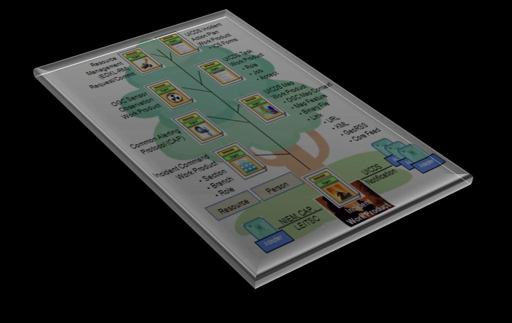
28 UICDS Tree of Incident Knowledge Page 28 Resource Management (EDXL-RM) Request/Commit OGC Sensor Observation Common Alerting Protocol (CAP) Incident Command Section Branch Role Resource Person NIEM, CAP, LEITSC Incident UICDS Incident Action Plan ICS Forms UICDS Task Role Job Accept UICDS Map OGC Map Context Map Feature Binary File Link URL KML GeoRSS Core Feed UICDS Notification Applications create an Incident Share Product in UICDS by using their preferred message format UICDS notifies other applications with a UCore Digest of the incident (or update) plus details to obtain the UICDS creates a Map to represent "where" and build a picture of the surrounding features UICDS creates an Incident Command to follow the who and how UICDS provides and consumes CAP alerts Tasking and dispatch applications assign jobs to people and units Sensor applications can contribute with video, chem-bio, flood, whatever sensor is available to help explain the incident Resource applications use EDXL-RM to request and commit resources and EDXL- DE for routing The Incident Action Plan is created from ICS Forms describing what will be done


29 Building a Continual, Virtual Shift Change Briefing Page 29
30 Examples of UICDS Information Sharing Page 30


31 Two-Way Collaboration Among Incident Applications and Publication to Geospatial Viewers 1 2 UICDS Core Metadata Digest 3 2 Page 31


32 Traffic and Security Video: SkyLine Network Solutions UICDS- Connected UICDS- Applications Connected Applications Integrating Video Content 1 3 UICDS Core Metadata Digest 2 4 Page 32


 Google")
")


33 Blue Force Tracking: US Army TARDEC JOC/Emergency Operations Center Resilient Initial Incident WP to MCAP Map WP with KML URIs MCAP Map WP with KML URI for Real Time Location MCAP Cloud MCAP Servers (Portal, DB, Apps) Google Maps Partner Systems Resilient (SCC) Page 33 MCAP DB and Core Service DB UICDS Node UICDS- Connected UICDS- Applications Connected Applications UICDS Node


34 NASA Jet Propulsion Laboratory Model Results E-DECIDER Project Goals: Transform and Distribute NASA Earth Science Data in support of Earthquake Mitigation and Response How to produce results that have immediate utility for disaster response? UICDS- Connected UICDS- Applications Connected Applications Simplified workflow Page 34

35 EPA ALOHA Plume Model Results UICDS Core Metadata Digest UICDS- Connected UICDS- Applications Connected Applications EPA ALOHA chemical plume model of possible airborne toxic release created in command vehicle, shared through UICDS to tablets in the field, to the EOC, and to all other UICDS-connected applications. Page 35


36 Utility Outage: UISOL UICDS- Connected UICDS- Applications Connected Applications UICDS Core Metadata Digest 2 4 Page 36


37 Field Observations Through Mobile Apps 1 UICDS Core Metadata Digest Red Alert to Possible, Nearby Damage Locations from UICDS App Provides Directions for Scientist, Engineer, and Responders Digest 2 3 Record Observations with Photographs, Video 5 4 UICDS- Connected UICDS- Applications Connected Applications Integrate USGS Field Notes for scientific, engineering, and damage assessment forms of emergency response and recovery Page 37

38 Local and National Alerts: IPAWS Page 38 UICDS-Connected Applications


39 ArcGIS Online Is the UICDS Geospatial Repository UICDS Core Metadata Digest Data Fractiona l Data ICDS Page 39


40 WebEOC Gateway: Super Bowl and Digital Sandbox Digital Sandbox Incident created: Pedestrian Struck on Royal Street UICDS Core Metadata Digest Pedestrian Struck on Royal Street in NIEM Incident Exchange Standard Format in UICDS Pedestrian Struck on Royal Street in WebEOC Page 40 The Pedestrian Struck on Royal Street also has a location which is shared through UICDS. UICDS- Connected UICDS- Applications Connected Applications

 4.")


41 National Retail Store Closure and Restoration Status 1. Store Status Output (Simple Spreadsheet) 4. To an Application that Adds Observation Data and Shares Back Through UICDS 5. To All Connected Applications that Have the Status and Local Observations UICDS- Connected UICDS- Applications Connected Applications 2. Shared Through UICDS UICDS Core Metadata Digest 3. To a COP Page 41


42 School Security at Indian Hills High School 1. School locations shared to CAD and mobile apps 7. To authorized organizations UICDS- Connected UICDS- Applications Connected Applications 6. And in an emergency, secure and silent reports from teachers on safety of students shared through UICDS 5. Emergency plan 3. Floor plans 2. Evacuation route to safe haven directions 4. Traffic and security cameras Page 42


43 County, State, Military Shared Situational Awareness: South Carolina Shared Situational Awareness Division of Emergency Management National Guard WebEOC Integration IPAWS Alerts Every county can create an alert within the county Share to UICDS Share to State State Authorizes to IPAWS Interact911 CAD and others Google Earth COP ESRI Flex Viewer COP UICDS Core Metadata Digest Page 43
44 2014 CAL OES Cascadia Subduction Zone Exercise Interoperability Deployment Google Earth and Others CalOES Position Log E-DECIDER And ARIA Clearinghouse Activity Log Other Agency Google Earth Page 44 FEMA Region IX WebEOC Watch Officer NASA JPL UICDS CalOES WebEOC Watch Officer Clearinghouse SpotOnResponse Mobile App Sig Events Incidents Field Observations Sig Events Incidents Field Observations Agreements and Filter Rules Incidents Field Observations FEMA GeoPortal (ArcGIS Online) FEMA Region IX UICDS Agreements and Filter Rules CalOES UICDS Incidents FEMA Region IX GeoPortal (ArcGIS Online) Incidents Field Observations Map Context Agreements and Filter Rules CalOES GeoPortal (ArcGIS Online) Field Observations Map Context CANG UICDS (Dot Mil Network) Agreements and Filter Rules CANG UICDS (Civilian Facing) CalFire NICS OES CatPlan GIS Layers Other Agency GIS Sources Map Context Real-Time GIS Map Features Feeds USE CASES 1. Field Observations and other real-time sources available in OES WebEOC 2. OES WebEOC sharing with FEMA IX WebEOC by rules Key 3. OES and FEMA GeoPortals depicting common information to executives Not Committed 2/28/14 DMZ
45 2014 CAL OES Cascadia Subduction Zone Exercise Interoperability Deployment Google Earth and Others CalOES Position Log E-DECIDER And ARIA Clearinghouse Activity Log Other Agency Google Earth Page 45 FEMA Region IX WebEOC Watch Officer NASA JPL UICDS CalOES WebEOC Watch Officer Clearinghouse SpotOnResponse Mobile App Sig Events Incidents Field Observations Sig Events Incidents Field Observations Agreements and Filter Rules Incidents Field Observations FEMA GeoPortal (ArcGIS Online) FEMA Region IX UICDS CalOES UICDS Incidents FEMA Region IX GeoPortal (ArcGIS Online) Incidents Field Observations Map Context Common Operational Data Agreements and Filter Rules Agreements and Filter Rules CalOES GeoPortal (ArcGIS Online) Field Observations Map Context CANG UICDS (Dot Mil Network) Agreements and Filter Rules CANG UICDS (Civilian Facing) CalFire NICS OES CatPlan GIS Layers Other Agency GIS Sources Map Context Real-Time GIS Map Features Feeds USE CASES 1. Field Observations and other real-time sources available in OES WebEOC 2. OES WebEOC sharing with FEMA IX WebEOC by rules Key 3. OES and FEMA GeoPortals depicting common information to executives Not Committed 2/28/14 DMZ
46 In Summary Page 46


47 The Enabling Solution for Incident Collaboration: UICDS Two-way collaborative information sharing through UICDS for all individuals, teams, and organizations in the public and private sector Existing applications connect to UICDS through accepted data exchange standards; there is no new user interface to learn, no application to buy, no cost to obtain it Data owners retain complete control over data sharing through UICDS by defining what information you share with your trusted partners Define the information you receive through UICDS from those trusted emergency planning and response partners Without any disruption to your operations, use the data, improve it, and add related data that is shared in the background through UICDS UICDS leads to better information from government better coordination with government less burden by government and added resiliency for critical infrastructure through information sharing Page 47
48 How Do You Get From Isolation and Fragmentation Sensor Readings Logs Checklists Photos? Plans Situation Reports Mobile App Dispatch Application Dispatch Inventory Diagrams Page 48 Incident Documents

49 UICDS Collaboration and Coordination Middleware COP Plans Photos Inventory Logs Sensor Readings Mobile App Checklists Situation Reports Diagrams Documents Dispatch Application Dispatch Incident Page 49
50 UICDS Project Manager Chip Mahoney (917) UICDS Community Outreach Director James W. Morentz, Ph.D. (703) Page 50
Unified Incident Command and Decision Support (UICDS)
") Unified Incident Command and Decision Support (UICDS) UICDS is the middleware foundation that enables information sharing and decision support among commercial and government incident management technologies
Unified Incident Command and Decision Support (UICDS) UICDS is the middleware foundation that enables information sharing and decision support among commercial and government incident management technologies
CLEARINGHOUSE EXERCISE PARTICIPATION DIRECTIONS: XCHANGECORE CONNECTOR FOR AGOL
 Ardent Sentry 15 (DOD)/California Capstone 15 (CalOES)/ SoCal Ex 15 (FEMA) CLEARINGHOUSE EXERCISE PARTICIPATION DIRECTIONS: XCHANGECORE CONNECTOR FOR AGOL Rosinski, Anne@conservation.ca.gov WHAT DOES PARTICIPATION
BUILD AND MAINTAIN SAFE COMMUNITIES WITH ARCGIS ONE PLATFORM, MANY MISSIONS
 BUILD AND MAINTAIN SAFE COMMUNITIES WITH ARCGIS ONE PLATFORM, MANY MISSIONS SAFETY AND SECURITY IN THE 21ST CENTURY National security, defense, and public safety agencies face challenges and threats that
Making Data and Mapping Platforms More Relevant and Useful During Decision Support
 Making Data and Mapping Platforms More Relevant and Useful During Decision Support GeoCollaborate - Rafael de Ameller - rafael@stormcenter.com - (202) 494-3477 Abstract Geographic Information Systems (GIS)
EMERGENCY SUPPORT FUNCTION (ESF) 13 PUBLIC SAFETY AND SECURITY
 13 PUBLIC SAFETY AND SECURITY") EMERGENCY SUPPORT FUNCTION (ESF) 13 PUBLIC SAFETY AND SECURITY PRIMARY AGENCY: SUPPORT AGENCIES: Savannah-Chatham Metropolitan Police Department Armstrong-Atlantic Campus Police Department Bloomingdale
EMERGENCY SUPPORT FUNCTION (ESF) 13 PUBLIC SAFETY AND SECURITY PRIMARY AGENCY: SUPPORT AGENCIES: Savannah-Chatham Metropolitan Police Department Armstrong-Atlantic Campus Police Department Bloomingdale
MASAS. Overview & Backgrounder Document. Consultation Package. CanOps
 CanOps Overview & Backgrounder Document Consultation Package Defining CanOpS Multi-Agency Situational Awareness System () is a national information aggregation system that facilitates sharing situational
Version 7 Overview. Key Features and Enhancements
 WebEOC Information Technology Professional Solutions Version 7 Overview Key Features and Enhancements WebEOC Version 7 delivers enhanced capabilities through an improved user interface, mapping features,
VirtualAgility solutions for. Smarter Public Safety. Michael V Kay VP European Operations VirtualAgility Inc.
 IBM Smarter Cities, Dublin 29th September 2010 Smarter Public Safety VirtualAgility solutions for Smarter Public Safety Michael V Kay VP European Operations VirtualAgility Inc. IBM is working across the
DHS S&T supports National Level Exercise 2011 using SUMMIT
 Fall 2011 STANDARD UNIFIED MODELING & MAPPING INTEGRATION TOOLKIT DHS S&T supports National Level Exercise 2011 using SUMMIT SUMMIT provides next-generation exercise capabilities to NLE 11 The Department
Emergency Operations Center Management Exercise Evaluation Guide
 Emergency Operations Center Management Exercise Evaluation Guide I respectfully submit the completed Exercise Evaluation Guide for the Canopy Oaks Tabletop Exercise conducted March 25 2010 for the Leon
GIS in Situational and Operational Awareness: Supporting Public Safety from the Operations Center to the Field
 GIS in Situational and Operational Awareness: Supporting Public Safety from the Operations Center to the Field Glasgow Bombings- June 2007 Law Enforcement, Public Safety and Homeland Security Organizations
Technological Advances In Emergency Management
 Technological Advances In Emergency Management Closing the gap between Preparation and Recovery Will Fontan, P.E. Regional Director, ONRG Americas Office Report Documentation Page Form Approved OMB No.
Command and Control for Security, Port Operations, and IT Considerations for Planning and Implementation
 Command and Control for Security, Port Operations, and IT Considerations for Planning and Implementation Port Operations, Safety and Information Technology Seminar Gary Hicks, Science Applications International
Florida State University
 Florida State University Disaster Recovery & Business Continuity Planning Overview October 24, 2017 1 Key Readiness Questions Has your department identified the business functions and infrastructure that
Integrating DHS Geospatial Tools, Infrastructure Data, and Standardized Symbology
 Integrating DHS Geospatial Tools, Infrastructure Data, and Standardized Symbology September 13-14, 2016 www.napsgfoundation.org @napsgfoundation napsgfoundation.org @napsgfoundation 1 Introduction napsgfoundation.org
DHS Emergency Services Sector Presents Tools and Resources for First Responders. June 1, pm ET
 DHS Emergency Services Sector Presents Tools and Resources for First Responders June 1, 2017 1-2 pm ET Agenda Introduction Overview of the NISC Emergency Services Sector (ESS) Resources and Tools for Emergency
CUSEC GIS/IT Working Group Brief. July 22, 2013 Meeting
 CUSEC GIS/IT Working Group Brief July 22, 2013 Meeting 1 INTRODUCTION In May June 2013, the CUSEC GIS/IT Working Group member states completed a written/verbal capabilities assessment The information gathered
Organize into a deployable resource that can be called up in an emergency Train GIS professionals to perform emergency response mapping Enhance the
 www.texasegrt.org Organize into a deployable resource that can be called up in an emergency Train GIS professionals to perform emergency response mapping Enhance the mapping capabilities of emergency responders
IA2. Flood (Including Dam Failure)
") IA2 Flood (Including Dam Failure) This page left blank intentionally. Marion 2. IA2 - Flood Phase of Activity PRE-INCIDENT PHASE RESPONSE PHASE Flood Incident Checklist Action Items Arrange for personnel
IA2 Flood (Including Dam Failure) This page left blank intentionally. Marion 2. IA2 - Flood Phase of Activity PRE-INCIDENT PHASE RESPONSE PHASE Flood Incident Checklist Action Items Arrange for personnel
ArcGIS Solutions for Community Resilience. Matthew S Deal
 ArcGIS Solutions for Community Resilience Matthew S Deal Solutions Overview Leverage hundreds of ready-to-use maps, apps, and platform configurations to meet your needs, delivering innovation and best
BUILD AND MAINTAIN SAFE COMMUNITIES WITH ARCGIS ONE PLATFORM, MANY MISSIONS
 BUILD AND MAINTAIN SAFE COMMUNITIES WITH ARCGIS ONE PLATFORM, MANY MISSIONS SAFETY AND SECURITY IN THE 21ST CENTURY National security, defence, and public safety agencies face challenges and threats that
Disaster Management (DM) Program Overview
 Program Overview") Disaster Management (DM) Program Overview Presented to Governing Board of the National Public Safety Telecommunications Council Chip Hines Program Manager Disaster Management e-gov Initiative Science and
Disaster Management (DM) Program Overview Presented to Governing Board of the National Public Safety Telecommunications Council Chip Hines Program Manager Disaster Management e-gov Initiative Science and
The age of location enlightenment
 The age of location enlightenment GIS in Public Safety. More than a map Chris McIntosh cmcintosh@esri.com Presentation Topics Patterns in Successful Deployments Requirements How GIS is Changing Examples
The Office of Infrastructure Protection
 The Office of Infrastructure Protection National Protection and Programs Directorate Department of Homeland Security Protective Security Advisors and Special Event Domestic Incident Tracker Overview Federal
EARTH Ex Exercise Webinar Multi-Sector Exercise Opportunity. July 19, pm ET
 EARTH Ex Exercise Webinar Multi-Sector Exercise Opportunity July 19, 2017 1-2 pm ET Agenda Introduction Overview of the NISC EARTH Ex 2017: Multi-Sector Exercise Opportunity Battle Rhythm Manager Q&A Quiz
DATA SHARING AND DISCOVERY WITH ARCGIS SERVER GEOPORTAL EXTENSION. Clive Reece, Ph.D. ESRI Geoportal/SDI Solutions Team
 DATA SHARING AND DISCOVERY WITH ARCGIS SERVER GEOPORTAL EXTENSION Clive Reece, Ph.D. ESRI Geoportal/SDI Solutions Team Geoportal Extension for ArcGIS Server Context within an Enterprise Spatial Data Infrastructure
TIES for Microsoft CityNext Next-Generation Situational Awareness
 BROCHURE A CLOSER LOOK AT! TIES for Microsoft CityNext Next-Generation Situational Awareness INTRODUCTION! TIES for Microsoft CityNext (TMCN) is an all-hazard threat monitoring and situation awareness
California Earthquake Clearinghouse. After Action Report: March 28, 2014, M 5.1 La Habra Earthquake Clearinghouse Activation
 California Earthquake Clearinghouse After Action Report: March 28, 2014, M 5.1 La Habra Earthquake Clearinghouse Activation Notification received at 9:11 p.m. via text from USGS Earthquake Notification
Jay English Director Comm. Center & Services APCO International. 2013; all rights reserved
 Jay English Director Comm. Center & 9-1-1 Services APCO International 2013; all rights reserved Topics to Cover NG9-1-1 What it means may vary Technical Basics New Terminology Issues that need to be on
2 ESF 2 Communications
 2 ESF 2 Communications THIS PAGE LEFT BLANK INTENTIONALLY Table of Contents 1 Introduction... 1 1.1 Purpose and Scope... 1 1.2 Relationship to Other ESF Annexes... 1 1.3 Policies and Agreements... 1 2
Emergency Management BCERMS Orientation
 Emergency Management BCERMS Orientation May 2008 Orientation Objectives Describe the primary responsibilities of emergency management programs for all levels of government in BC Explain BCERMS British
Arizona State Troopers Highway Patrol Division Sergeant John Paul Cartier
 Arizona State Troopers Highway Patrol Division Sergeant John Paul Cartier Average Annual Number of Responders Struck and Killed Nationally 12 Law Enforcement Officers 5 Fire and Rescue Personnel 60 Towing
FEMA Update. Tim Greten Technological Hazards Division Deputy Director. NREP April 2017
 FEMA Update Tim Greten Technological Hazards Division Deputy Director NREP April 2017 FEMA Strategic Priorities Priority 1: Be survivor-centric in mission and program delivery. Priority 2: Become an expeditionary
STANDARD OPERATING PROCEDURE Critical Infrastructure Credentialing/Access Program Hurricane Season
 STANDARD OPERATING PROCEDURE Critical Infrastructure Credentialing/Access Program Hurricane Season IBERIA PARISH STATE OF LOUISIANA STANDARD OPERATING PROCEDURE Critical Infrastructure Owners/Operators
BROADBAND AND THE FUTURE USER S EXPERIENCE
 Emerging Technologies Forum BROADBAND AND THE FUTURE USER S EXPERIENCE Richard Coupland Director, Public Safety Market Development, GDC4S 04 December 2013 Emerging Technologies in Public Safety Public
Best Practices for Incident Communications: Simplifying the Mass Notification Process for Government
 Best Practices for Incident Communications: Simplifying the Mass Notification Process for Government Introduction State and local governments and their supporting agencies encounter emergency situations
JSC THE JUSTICE & SAFETY CENTER. Snapshot 2014
 JSC THE JUSTICE & SAFETY CENTER Snapshot 2014 The Justice & Safety Center (JSC) is comprised of a team of faculty and staff professionals at Eastern Kentucky University (EKU) dedicated to strengthening
Enabling Operational Innovation and Building Resilience
 Enabling Operational Innovation and Building Resilience National Geospatial Preparedness Summit September 14, 2016 Dan Cotter Director First Responders Group Science and Technology Directorate S&T Visionary
Business Continuity Planning
 Business Continuity Planning The Unexpected Happens Be Ready Copyright -Business Survival Partners, llc. 2011 - All Rights Reserved www.survivalpartners.biz RISK 2 Risks to National Security A secure and
Cyber Security & Homeland Security:
 Cyber Security & Homeland Security: Cyber Security for CIKR and SLTT Michael Leking 19 March 2014 Cyber Security Advisor Northeast Region Office of Cybersecurity and Communications (CS&C) U.S. Department
TARGETING CITIZENS WITH LOCATION BASED NOTIFICATIONS.
 TARGETING CITIZENS WITH LOCATION BASED NOTIFICATIONS Introduction State and local government departments, agencies and groups face a wide variety of events. Each have their own unique characteristics.
Disaster Mitigation Projects in Polis. December 14, 2016
 1 Disaster Mitigation Projects in Polis December 14, 2016 Briefing Agenda 2 About Polis Multi s Mitigation Planning Flood s s Disaster Mitigation Platforms Consultancies Training Discussion 3 About us
Office DEPOT 1. Table of Contents. About Office Depot Global HQ in Delray Beach, FL. May 5-7, 2008
 Continuity Insights Management Conference 2008 -------------------------------------------- Public-Private Private Partnerships: A Grass-Roots Approach Presented By: Tom Serio Director - Global Business
Overview of the Esri Disaster Response Program and Lessons Learned from Past Events. Jeff Baranyi
 Overview of the Esri Disaster Response Program and Lessons Learned from Past Events Jeff Baranyi Mission Statement The mission of the Esri Public Safety Assistance Program is to establish Esri as a good
Local Government Disaster Planning and what can be learned from it.
 Local Government Disaster Planning and what can be learned from it. Emergency Operations Plans Emergency Support Functi0ns: ESF-1 ESF-2 ESF-3 ESF-4 ESF-5 ESF-6 ESF-7 Transportation Communications Public
Critical Infrastructure Partnership
 Critical Infrastructure Partnership Overview Chris Boyer AVP Global Public Policy December 11, 2017 2016 AT&T Intellectual Property. All rights reserved. AT&T, Globe logo, Mobilizing Your World and DIRECTV
Emergency Management GIS Data & Coordination: Lessons Learned & How We All Can Be Better Prepared for Future Disasters
 Emergency Management GIS Data & Coordination: Lessons Learned & How We All Can Be Better Prepared for Future Disasters Ashlee Llewellyn, GISP Information Technology Services Dept. Ashlee.Llewellyn@countyofnapa.org
February 21, pm ET
 February 21, 2018 1-2 pm ET Agenda Introduction Overview of the NISC G&H International Services: Practical Tools for Better Decision- Making Q&A Quiz for those seeking Continuing Education Units (CEUs)
Georgia Online Disaster Awareness Geospatial System. Training Workbook
 Georgia Online Disaster Awareness Geospatial System Training Workbook Picture: Hurricane Irene, August 2011 For Training and Access Information Contact Planning/GIS (404) 635-7212 (404) 624-2636 https://godawgs.gema.ga.gov/gema2/
Feb 28 Mar, 7 Raleigh, NC
 NCC National Coordinating Center for Communications Gerald Jay English, ENP Public Safety Program Manager US Dept. of Homeland Security National Communications & Cybersecurity Information Center (NCCIC)
FEMA Region IX. RRCC Watch Center. August 2009
 FEMA Region IX RRCC Watch Center August 2009 Mission The Regional Response Coordination Center (RRCC) Watch Center is a 24-Hour, 7-Day-Per-Week Function that maintains Regional Situational Awareness of
Science & Technology Directorate: R&D Overview
 Science & Technology Directorate: R&D Overview August 6 th, 2012 UNCLASSIFIED//FOUO DHS S&T Mission Strengthen America s security and resiliency by providing knowledge products and innovative technology
June 5, 2018 Independence, Ohio
 June 5, 2018 Independence, Ohio The Office of Infrastructure Protection National Protection and Programs Directorate Department of Homeland Security Securing the Nation at the Community Level 2018 Cuyahoga
Planning for Resiliency. June 20, 2017 Richard Tetreault, PE WSP USA Office Lead VT, NH, and ME
 Planning for Resiliency June 20, 2017 Richard Tetreault, PE WSP USA Office Lead VT, NH, and ME 23,000 years ago there would have been more than 8,000 feet of glacier over our heads 2 Provide for the safe
CRITICAL INFORMATION SYSTEMS
 CRITICAL INFORMATION SYSTEMS Jeff Newbold State Coordinator for Critical Information Systems Texas Division of Emergency Management DISCUSSION POINTS WebEOC Endeavors Regional Advisory Groups and State
MULTI-YEAR TRAINING AND EXERCISE PLAN. Boone County Office of Emergency Management
 2017-2019 MULTI-YEAR TRAINING AND EXERCISE PLAN Boone County Office of February 2017 PREFACE The utilizes a coordinated preparedness strategy that combines enhanced planning, resource acquisition, innovative
TX360 Use Cases And Case Studies
 SWAN ISLAND NETWORKS EXAMPLES TX60 Use Cases And Case Studies 205 Swan Island Networks, Inc. Introduction For over a decade, Swan Island Networks has been providing innovative threat intelligence and situational
Enterprise Geographic Information Servers. Dr David Maguire Director of Products Kevin Daugherty ESRI
 Enterprise Geographic Information Servers Dr David Maguire Director of Products Kevin Daugherty ESRI Outline Introduction Enterprise GIS vs. Spatially-enabled IS Architectures for building Enterprise GIS
SITUATIONAL AWARENESS FOR NORTH CAROLINA S MODERN ENTERPRISE
 SITUATIONAL AWARENESS FOR NORTH CAROLINA S MODERN ENTERPRISE Joint Legislative Emergency Management Oversight Committee February 15, 2018 TigerSwan Headquarters: Apex, North Carolina, Founded 2008 Service-Disabled,
Homeland Security: Requirements for Installation Security Decision Support Systems. Battle Command Battle Lab Gordon
 Homeland Security: Requirements for Installation Security Decision Support Systems COE post 9 / 11 CONUS and OCONUS installations must be prepared for and capable of preventing terrorist, criminal and
Alcatel-Lucent OmniTouch My Teamwork. Land Mobile Radio Conferencing and Collaboration (LMRCC)
") Alcatel-Lucent OmniTouch My Teamwork Land Mobile Conferencing and Collaboration (LMRCC) For on site mobile and remote staff in public safety, enterprise, and instutional environments, the office is not
Alcatel-Lucent OmniTouch My Teamwork Land Mobile Conferencing and Collaboration (LMRCC) For on site mobile and remote staff in public safety, enterprise, and instutional environments, the office is not
PortSec: A Port Security Risk Analysis and Resource Allocation System
 PortSec: A Port Security Risk Analysis and Resource Allocation System Michael D. Orosz, Ph.D. Computer Scientist Lead, Decision Systems Group mdorosz@isi.edu 310-448-8266 Information Sciences Institute
City of Stamford OFFICE OF PUBLIC SAFETY. Public Safety Administration. FY Budget Presentation
 City of Stamford OFFICE OF PUBLIC SAFETY Public Safety Administration FY 2016-17 Budget Presentation Office of Public Safety Services Provided & Mission Statement The Office of Public Safety, Health and
and The Technical Assist Database Presented to the Regional GIS Council October 8, 2008
 and The Technical Assist Database Presented to the Regional GIS Council October 8, 2008 After the catastrophic wildfires of October 2003, the San Diego Regional Fire Prevention and Emergency Preparedness
White Paper: Next generation disaster data infrastructure CODATA LODGD Task Group 2017
 White Paper: Next generation disaster data infrastructure CODATA LODGD Task Group 2017 Call for Authors This call for authors seeks contributions from academics and scientists who are in the fields of
BUSINESS CONTINUITY MANAGEMENT PROGRAM OVERVIEW
 BUSINESS CONTINUITY MANAGEMENT PROGRAM OVERVIEW EXECUTIVE SUMMARY CenturyLink is committed to ensuring business resiliency and survivability during an incident or business disruption. Our Corporate Business
COMMUNICATIONS EMERGENCY SUPPORT FUNCTION (ESF #2) FORMERLLY COMMUNICATIONS AND WARNING
 FORMERLLY COMMUNICATIONS AND WARNING") ICS Category: Operations ESF # 2 Responsible for the EOC message center, providing working radio & telephone equipment, and providing warning to vulnerable facilities Reports to the emergency management
ICS Category: Operations ESF # 2 Responsible for the EOC message center, providing working radio & telephone equipment, and providing warning to vulnerable facilities Reports to the emergency management
Business Continuity and Disaster Recovery. Pennsylvania Emergency Management Agency (PEMA) Satellite Warning System/Rapid Notification Network
 Satellite Warning System/Rapid Notification Network") Business Continuity and Disaster Recovery Pennsylvania Emergency Management Agency (PEMA) Satellite Warning System/Rapid Notification Network Executive Summary Too often emergency management communication
Business Continuity and Disaster Recovery Pennsylvania Emergency Management Agency (PEMA) Satellite Warning System/Rapid Notification Network Executive Summary Too often emergency management communication
UNCLASSIFIED. National and Cyber Security Branch. Presentation for Gridseccon. Quebec City, October 18-21
 National and Cyber Security Branch Presentation for Gridseccon Quebec City, October 18-21 1 Public Safety Canada Departmental Structure 2 National and Cyber Security Branch National and Cyber Security
NATIONAL CAPITAL REGION HOMELAND SECURITY STRATEGIC PLAN SEPTEMBER 2010 WASHINGTON, DC
 NATIONAL CAPITAL REGION HOMELAND SECURITY STRATEGIC PLAN SEPTEMBER 2010 WASHINGTON, DC Draft Version incorporating Management Review [MR] Edits and Comments Document Date: July 2013 Goal One: Ensure Interoperable
Railroad Infrastructure Security
 TRB Annual Meeting January 14, 2002 Session 107 - Railroad Security William C. Thompson william.thompson@jacobs.com 402-697-5011 Thanks to: Bob Ulrich Dr. William Harris Byron Ratcliff Frank Thigpen John
BUSINESS DISASTER & TERRORISM PREPAREDNESS
 BUSINESS DISASTER & TERRORISM PREPAREDNESS MINORITY CHAMBER OF COMMERCE, CYBER SECURITY FORUM MIAMI-DADE PUBLIC-PRIVATE PARTNERSHIP The Public-Private Partnership program incorporates the public and private
UF CEMP Support Group Annex: Public Safety
 UF CEMP Support Group Annex: Public Safety Lead Representatives University of Supporting Departments External Partners Enrollment Management Shands Hospital Safety & Security Alachua County Emergency Management
Kansas City s Metropolitan Emergency Information System (MEIS)
") Information- Sharing Interagency Cooperation Resources Management Law Enforcement Fire Emergency Medical Services Public Health Private Sector Kansas City s Metropolitan Emergency Information System (MEIS)
Information- Sharing Interagency Cooperation Resources Management Law Enforcement Fire Emergency Medical Services Public Health Private Sector Kansas City s Metropolitan Emergency Information System (MEIS)
2013 STRATEGIC PLANNING SCHEDULE
 2013 STRATEGIC PLANNING SCHEDULE Overall Agency Priorities 1. Prepare for the 2013 Hurricane Conference 2. Coordinate the Adoption and Implementation of the Employee State of Emergency Work Assignment
SAS SOLUTIONS ONDEMAND
 DECEMBER 4, 2013 Gary T. Ciampa SAS Solutions OnDemand Advanced Analytics Lab Birmingham Users Group, 2013 OVERVIEW SAS Solutions OnDemand Started in 2000 SAS Advanced Analytics Lab (AAL) Created in 2007
OEMC 2016 Budget Statement of Executive Director Gary W. Schenkel to the Committee on Budget and Operations September 30, 2015
 OEMC 2016 Budget Statement of Executive Director Gary W. Schenkel to the Committee on Budget and Operations September 30, 2015 Good morning, Chairman Austin, Vice Chairman Ervin and members of the City
Welcome to the AEMA Regional Outreach
 Welcome to the AEMA Regional Outreach Intent and Purpose Share Information Strengthen Networks Get Feedback / Identify Issues Say Thank you! 2 Major Threats Summer storms Petro-Chemical release Public
STRATEGIC PLAN. USF Emergency Management
 2016-2020 STRATEGIC PLAN USF Emergency Management This page intentionally left blank. Organization Overview The Department of Emergency Management (EM) is a USF System-wide function based out of the Tampa
Disaster Management Interoperability Services (DMIS)
") Disaster Management Interoperability Services (DMIS) Disaster Management egov Initiative (DM) Technologies for Critical Incident Preparedness Conference and Exposition 2005 October 31, 2005 DM Initiative
Disaster Management Interoperability Services (DMIS) Disaster Management egov Initiative (DM) Technologies for Critical Incident Preparedness Conference and Exposition 2005 October 31, 2005 DM Initiative
Mobile Incident Command and Accountability System An Emergency Responder Prototype and Pilot System
 Mobile Incident Command and Accountability System An Emergency Responder Prototype and Pilot System ESRI Homeland Security Conference Chris Couper 916 641 4492 ccouper@us.ibm.com IBM MICAS 9/13/2005 Challenges
Google Cloud & the General Data Protection Regulation (GDPR)
") Google Cloud & the General Data Protection Regulation (GDPR) INTRODUCTION General Data Protection Regulation (GDPR) On 25 May 2018, the most significant piece of European data protection legislation to
Google Cloud & the General Data Protection Regulation (GDPR) INTRODUCTION General Data Protection Regulation (GDPR) On 25 May 2018, the most significant piece of European data protection legislation to
Hippocrates. Situational Awareness Application ESRI. October, 2007
 Hippocrates New Jersey s Health System Situational Awareness Application ESRI October, 2007 New Jersey s Health System 8.7 million people 566 municipalities 114 local health departments 21 counties 22
Applying Mitigation. to Build Resilient Communities
 Applying Mitigation to Build Resilient Communities The Hazards Around Us Think about the natural hazard that... poses the greatest risk to where you live or work OR has had the greatest impact on you personally
Web Based Emergency Operations Data Fusion
 Web Based Emergency Operations Data Fusion Lessons Learned Hurricanes Katrina and Gustav Situational Awareness Intelligence (who, what, when, where) Centralized Command and Control Communication Continuity
PA Homeland Security/Public Safety Geospatial Portal Applications
 PA Homeland Security/Public Safety Geospatial Portal Applications ESRI FedUC 2006 Washington, DC Jim Knudson (jknudson@state.pa.us) Stacey White (stwhite@state.pa.us) GTO Homeland Security Priorities Understanding
Emergency Management Update. June 2018
 Emergency Management Update June 2018 Overview 1. Emergency Management Guide Auditor General for Local Governments 2. Next Generation Radio System 3. Information Systems 4. 2018 Full Scale Earthquake Exercise
Discovery and Access of Geospatial Resources Using GIS Portal Toolkit Marten Hogeweg Product Manager GIS Portal Toolkit
 Discovery and Access of Geospatial Resources Using GIS Portal Toolkit Marten Hogeweg Product Manager GIS Portal Toolkit Outline Elements of Spatial Data Infrastructures Current trends Position of GIS portals
REGIONAL UTILITY COORDINATION PLAN. Portland, Oregon / Vancouver, Washington Metropolitan Area
 REGIONAL UTILITY COORDINATION PLAN Portland, Oregon / Vancouver, Washington Metropolitan Area I. PURPOSE The purpose of this plan is to outline procedures for coordination between local governments and
The Office of Infrastructure Protection
 The Office of Infrastructure Protection National Protection and Programs Directorate Department of Homeland Security Chemical Facility Anti-Terrorism Standards (CFATS) Mystic REPC October 23, 2018 The
DHS Supply Chain Activity: Cross-Sector Supply Chain Working Group and Strategy on Global Supply Chain Security
 DHS Supply Chain Activity: Cross-Sector Supply Chain Working Group and Strategy on Global Supply Chain Security Josha Jordan U.S. Department of Homeland Security National Protection and Programs Directorate
La gestione di Security e Safety con un singolo sistema di supporto alle decisioni Baltimore/Washington Airport - USA
 La gestione di Security e Safety con un singolo sistema di supporto alle decisioni Baltimore/Washington Airport - USA Filippo Silvestri Sales Manager PS&S Intergraph Italia Security Government & Infrastructure
ICT and emergencies! in historic districts
 ICT and emergencies! in historic districts (how ICT improves large scale emergency operations involving historical buildings) Stefano Marsella stefano.marsella@vigilfuoco.it Technical Rescue Operations
Office for Interoperability and Compatibility Emergency Interoperable Standards Efforts
 Office for Interoperability and Compatibility Emergency Interoperable Standards Efforts 8th Annual Technologies for Critical Incident Preparedness Conference and Exposition Chip Hines Director, Office
Alternative Fuel Vehicles in State Energy Assurance Planning
 + Alternative Fuel Vehicles in State Energy Assurance Planning July 17, 2014 Webinar hosted by the National Association of State Energy Officials (NASEO), with support from the U.S. Department of Energy
Android Team Awareness Kit (ATAK) and ArcGIS
 and ArcGIS") Android Team Awareness Kit (ATAK) and ArcGIS Darron Pustam Product Manager, Esri Craig Cleveland Product Engineer, Esri Verne LaClair Product Manager, PAR Agenda Connecting Intel and Operations in Real
Android Team Awareness Kit (ATAK) and ArcGIS Darron Pustam Product Manager, Esri Craig Cleveland Product Engineer, Esri Verne LaClair Product Manager, PAR Agenda Connecting Intel and Operations in Real
Central U.S. Earthquake Consortium CAPSTONE-14 Exercise After-Action Report
 Department of Homeland Security Science and Technology Directorate Washington, DC October 2014 Central U.S. Earthquake Consortium CAPSTONE-14 Exercise After-Action Report by First Responders Group Department
NFPA 3000 (PS) Standard for an Active Shooter / Hostile Event Response (ASHER) Program IT S A BIG WORLD. LET S PROTECT IT TOGETHER.
 Standard for an Active Shooter / Hostile Event Response (ASHER) Program IT S A BIG WORLD. LET S PROTECT IT TOGETHER.") NFPA 3000 (PS) Standard for an Active Shooter / Hostile Event Response (ASHER) Program IT S A BIG WORLD. LET S PROTECT IT TOGETHER. TM Active Shooter Incidents: 2000-2017 2 Active Shooter Incidents: 2016
NFPA 3000 (PS) Standard for an Active Shooter / Hostile Event Response (ASHER) Program IT S A BIG WORLD. LET S PROTECT IT TOGETHER. TM Active Shooter Incidents: 2000-2017 2 Active Shooter Incidents: 2016
Does Your Data Have Harmony. Dan Stone
 Does Your Data Have Harmony Dan Stone Agenda Introduction Configuration Patterns Implementation Approaches Your Feedback ArcGIS for Local Government Esri solutions for local government customers Series
Developing a National Emergency Telecommunications Plan. The Samoan Experience November 2012
 Developing a National Emergency Telecommunications Plan The Samoan Experience November 2012 What is The NETP? The National Emergency Telecoms Plan (NETP) is a strategic plan that establishes a national