Strabon. Semantic support for EO Data Access in TELEIOS. Presenter: George Garbis
|
|
|
- Brittany Tate
- 5 years ago
- Views:
Transcription

1 Strabon Semantic support for EO Data Access in TELEIOS Presenter: George Garbis Dept. of Informatics and Telecommunications National and Kapodistrian University of Athens June 23 Florence, Italy
2 Outline Motivation Representing and Querying Geospatial and Temporal Information in RDF Applications The Fire Monitoring Service of the National Observatory of Athens The TerraSAR-X Virtual Observatory of the German Aerospace Center Thoughts for discussion 2


3 State of the Art in EO Data Centers Users EOWEB EO data center Catalogue Raw Data Processing Chains Archive 3
4 Example Can I pose the following query using EOWEB? Find images taken by the SEVIRI satellite on August 25, 2007 which contain fire hotspots in areas which have been classified as forests according to CORINE Land Cover, and are located within 2km from an archaeological site in the Peloponnese. 4
")
5 Example (cont d) 5
6 Example (cont d) Well, only partially. Find images taken by the SEVIRI satellite on August 25, 2007 which contain fire hotspots in areas which have been classified as forests according to CORINE Land Cover, and are located within 2km from an archaeological site in the Peloponnese. 6
7 Example (cont d) But why? All this information is available in the satellite images and other auxiliary data sources of EO data centers or on the Web. However, EO data centers today do not allow: mining of satellite image content and its integration with other relevant data sources so the previous query can be answered. 7
8 High Level Data Modeling Need for representing Standard product metadata Standard product semantic annotations Geospatial information Temporal information Need to link to other data sources GIS data Other information on the Web 8

9 Semantics-Based Representation and Querying of EO Data The data model strdf and the query language stsparql The system Strabon 9
10 Outline Motivation Representing and Querying Geospatial and Temporal Information in RDF Applications The Fire Monitoring Service of the National Observatory of Athens The TerraSAR-X Virtual Observatory of the German Aerospace Center Conclusions 10
11 RDF: Resource Description Framework W3C recommendation RDF is a graph data model ( + XML syntax + semantics) For representing metadata For describing the semantics of information in a machine-readable way Resources are described in terms of properties and property values using RDF statements Statements are represented as triples, consisting of a subject, predicate and object. ex:burntarea1 noa:hasarea " "^^xsd:double 11 11
12 The Data Model strdf strdf stands for spatial/temporal RDF. It is an extension of the W3C standard RDF for the representation of geospatial data that may change over time. strdf extends RDF with: Spatial literals encoded in OGC standards Well-Known Text or GML New datatypes for spatial literals (strdf:wkt, strdf:gml and strdf:geometry) Temporal literals can be either periods or instants New datatype for temporal literals (strdf:period) Placed as the fourth component of a triple to denote valid time 12

13 strdf: An example (1/2) 13
14 strdf: An example (1/2) ex:burntarea1 14
15 strdf: An example (1/2) noa:burntarea rdf:type ex:burntarea1 15
16 strdf: An example (1/2) noa:burntarea noa:hasid 1 ^^xsd:int rdf:type ex:burntarea1 16
17 strdf: An example (1/2) noa:burntarea noa:hasid 1 ^^xsd:int rdf:type ex:burntarea1 noa:hasarea " "^^xsd:double 17
18 strdf: An example (1/2) noa:burntarea noa:hasid 1 ^^xsd:int rdf:type ex:burntarea1 noa:hasarea " "^^xsd:double geo:geometry "POLYGON(( , , , , )); < ^^strdf:wkt 18
19 strdf: An example (1/2) noa:burntarea noa:hasid 1 ^^xsd:int rdf:type ex:burntarea1 noa:hasarea " "^^xsd:double geo:geometry "POLYGON(( , , , , )); < ^^strdf:wkt Spatial Data Type for Geospatial Applications, Well-Known Workshop in INSPIRE Text Conference


); <http://spatialreference.")

20 strdf: An example (1/2) noa:burntarea noa:hasid 1 ^^xsd:int rdf:type Spatial Literal (OpenGIS Simple Features) ex:burntarea1 noa:hasarea geo:geometry " "^^xsd:double "POLYGON(( , , , , )); < ^^strdf:wkt Spatial Data Type for Geospatial Applications, Well-Known Workshop in INSPIRE Text Conference
21 stsparql: An example (1/2) Find all burned forests within 10kms of a city SELECT?BA?BAGEO WHERE {?R rdf:type noa:region.?r geo:hasgeometry?rgeo.?r noa:hascorinelandcoveruse..?f rdfs:subclassof clc:forests.?city rdf:type dbpedia:city.?city geo:hasgeometry?cgeo.?ba rdf:type noa:burntarea.?ba geo:hasgeometry?bageo. FILTER( strdf:intersect(?rgeo,?bageo) && strdf:distance(?rgeo,?cgeo,uom:km)<10)} 21
22 stsparql: An example (1/2) Find all burned forests within 10kms of a city SELECT?BA?BAGEO WHERE {?R rdf:type noa:region.?r geo:hasgeometry?rgeo.?r noa:hascorinelandcoveruse..?f rdfs:subclassof clc:forests.?city rdf:type dbpedia:city.?city geo:hasgeometry?cgeo.?ba rdf:type noa:burntarea.?ba geo:hasgeometry?bageo. FILTER( strdf:intersect(?rgeo,?bageo) && strdf:distance(?rgeo,?cgeo,uom:km)<10)} 22
23 stsparql: An example (1/2) Find all burned forests within 10kms of a city SELECT?BA?BAGEO WHERE {?R rdf:type noa:region.?r geo:hasgeometry?rgeo.?r noa:hascorinelandcoveruse..?f rdfs:subclassof clc:forests.?city rdf:type dbpedia:city.?city geo:hasgeometry?cgeo.?ba rdf:type noa:burntarea.?ba geo:hasgeometry?bageo. FILTER( strdf:intersect(?rgeo,?bageo) && strdf:distance(?rgeo,?cgeo,uom:km)<10)} 23
24 stsparql: An example (1/2) Find all burned forests within 10kms of a city SELECT?BA?BAGEO WHERE {?R rdf:type noa:region.?r geo:hasgeometry?rgeo.?r noa:hascorinelandcoveruse..?f rdfs:subclassof clc:forests.?city rdf:type dbpedia:city.?city geo:hasgeometry?cgeo.?ba rdf:type noa:burntarea.?ba geo:hasgeometry?bageo. FILTER( strdf:intersect(?rgeo,?bageo) && strdf:distance(?rgeo,?cgeo,uom:km)<10)} 24
25 stsparql: An example (1/2) Find all burned forests within 10kms of a city SELECT?BA?BAGEO WHERE {?R rdf:type noa:region.?r geo:hasgeometry?rgeo.?r noa:hascorinelandcoveruse..?f rdfs:subclassof clc:forests.?city rdf:type dbpedia:city.?city geo:hasgeometry?cgeo.?ba rdf:type noa:burntarea.?ba geo:hasgeometry?bageo. FILTER( strdf:intersect(?rgeo,?bageo) && strdf:distance(?rgeo,?cgeo,uom:km)<10)} 25
26 stsparql: An example (1/2) Find all burned forests within 10kms of a city SELECT?BA?BAGEO WHERE {?R rdf:type noa:region.?r geo:hasgeometry?rgeo.?r noa:hascorinelandcoveruse..?f rdfs:subclassof clc:forests.?city rdf:type dbpedia:city.?city geo:hasgeometry?cgeo.?ba rdf:type noa:burntarea.?ba geo:hasgeometry?bageo. FILTER( strdf:intersect(?rgeo,?bageo) && strdf:distance(?rgeo,?cgeo,uom:km)<10)} 26

 FILTER( strdf:intersect(?rgeo,?bageo) && strdf:distance(?rgeo,?cgeo,uom:km)<10)} 27")
27 stsparql: An example (1/2) Find all burned forests within 10kms of a city SELECT?BA?BAGEO WHERE {?R rdf:type noa:region.?r geo:hasgeometry?rgeo.?r noa:hascorinelandcoveruse..?f rdfs:subclassof clc:forests.?city rdf:type dbpedia:city.?city geo:hasgeometry?cgeo.?ba rdf:type noa:burntarea.?ba geo:hasgeometry?bageo. Spatial Functions (OGC Simple Feature Access) FILTER( strdf:intersect(?rgeo,?bageo) && strdf:distance(?rgeo,?cgeo,uom:km)<10)} 27
28 stsparql: An example (1/2) 28
29 strdf: An example (2/2) clc:region1 clc:haslandcover clc:forest
30 strdf: An example (2/2) clc:region1 clc:haslandcover clc:forest. "[ T11:00:00+02, T11:00:00+02)"^^strdf:period
31 strdf: An example (2/2) clc:region1 clc:haslandcover clc:forest. "[ T11:00:00+02, T11:00:00+02)"^^strdf:period. noa:ba1 rdf:type noa:burntarea "[ T11:00:00+02, T11:00:00+02)"^^strdf:period

\"^^strdf:period.")
32 strdf: An example (2/2) clc:region1 clc:haslandcover clc:forest. "[ T11:00:00+02, T11:00:00+02)"^^strdf:period. noa:ba1 rdf:type noa:burntarea "[ T11:00:00+02, T11:00:00+02)"^^strdf:period. clc:region1 clc:haslandcover clc:agriculturalarea "[ T11:00:00+02, "UC")"^^strdf:period
33 stsparql: An example (2/2) Find all areas that were forests in 2006 and got burned later within 10kms of a city SELECT?BA?BAGEO WHERE {?R rdf:type noa:region.?r geo:geometry?rgeo ;?R noa:hascorinelandcoveruse?f?t1..?f rdfs:subclassof clc:forests.?city rdf:type dbpedia:city.?city geo:geometry?cgeo.?ba rdf:type noa:burntarea?t2.?ba geo:geometry?bageo. FILTER( strdf:intersect(?rgeo,?bageo) && strdf:distance(?rgeo,?cgeo,uom:km)<10) FILTER( strdf:during(?t1, [ :00:00:01, :23:59:59] ^^strdf:period)) && strdf:before(?t1,?t2) } 33
34 stsparql: An example (2/2) Find all areas that were forests in 2006 and got burned later within 10kms of a city SELECT?BA?BAGEO WHERE {?R rdf:type noa:region.?r geo:geometry?rgeo ;?R noa:hascorinelandcoveruse?f?t1..?f rdfs:subclassof clc:forests.?city rdf:type dbpedia:city.?city geo:geometry?cgeo.?ba rdf:type noa:burntarea?t2.?ba geo:geometry?bageo. FILTER( strdf:intersect(?rgeo,?bageo) && strdf:distance(?rgeo,?cgeo,uom:km)<10) FILTER( strdf:during(?t1, [ :00:00:01, :23:59:59] ^^strdf:period)) && strdf:before(?t1,?t2) } 34

35 stsparql: An example (2/2) Find all areas that were forests in 2006 and got burned later within 10kms of a city SELECT?BA?BAGEO WHERE {?R rdf:type noa:region. Temporal extension functions?r geo:geometry?rgeo ;?R noa:hascorinelandcoveruse?f?t1..?f rdfs:subclassof clc:forests.?city rdf:type dbpedia:city.?city geo:geometry?cgeo.?ba rdf:type noa:burntarea?t2.?ba geo:geometry?bageo. FILTER( strdf:intersect(?rgeo,?bageo) && strdf:distance(?rgeo,?cgeo,uom:km)<10) FILTER( strdf:during(?t1, [ :00:00:01, :23:59:59] ^^strdf:period)) && strdf:before(?t1,?t2) } 35
")
36 stsparql: An example (2/2) 36
37 stsparql: More details We start from SPARQL 1.1. We add a SPARQL extension function for each function defined in the OGC standard OpenGIS Simple Feature Access Part 2: SQL option (ISO 19125) for adding geospatial data to relational DBMSs and SQL. We add a set of temporal functions (superset of Allen s functions) as SPARQL extension functions We add appropriate geospatial and temporal extensions to SPARQL 1.1 Update language 37
38 stsparql vs. GeoSPARQL GeoSPARQL is a recent OGC standard to develop an extension of SPARQL for querying geospatial data expressed in RDF. stsparql and GeoSPARQL have been developed independently. stsparql geospatial query functionality is very close to a subset of GeoSPARQL: Core Geometry extension Geometry topology extension GeoSPARQL goes beyond stsparql: binary topological relations as RDF properties (spatial reasoners) Additional stsparql features: Geospatial aggregation functions Temporal literals 38

39 Strabon: A Scalable Geospatial RDF Store WKT Period GML Strabon Sesame Query Engine Storage Manager Parser Repository Optimizer SAIL strdf graphs Evaluator Transaction Manager RDBMS stsparql/ GeoSPARQL queries GeneralDB PostgreSQL PostGIS PostgreSQL Temporal 39
40 Outline Motivation Representing and Querying Geospatial and Temporal Information in RDF Applications The Fire Monitoring Service of the National Observatory of Athens The TerraSAR-X Virtual Observatory of the German Aerospace Center Conclusions 40


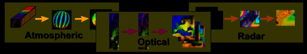
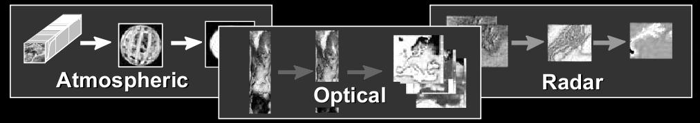
41 Use Case I: Real-Time Fire Monitoring (NOA) 9.5 East Back End: MonetDB / Strabon CORINE Landcover Admin Boundaries POIs External Sources Linked Geospatial Data Semantic technologies Geospatial Ontology Web access based on Semantics HotSpots Raw Data Data Vault Processing Chain (SciQL based) Search & Display Search for raw & Processing Real-time Fire Monitoring Refinement (Post-Processing) Linked Data 41 7/1/
42 NOA Ontology 42
43 NOA Ontology 43
44 Linked Geospatial Data Datasets that we published as linked data: CORINE Land Use / Land Cover Coastline of Greece Greek Administrative Geography Portal: Datasets from Linked Open Data Cloud OpenStreetMap GeoNames 44
45 Linked Open Data Cloud 45


46 Linked Open Data Cloud 46

47 Linked Open Data GeoNames 47

48 Linked Open Data OpenSteetMap Published by LinkedGeoData 48

49 Linked Open Data Greek Administrative Geography 49

50 Linked Open Data CORINE Land Use / Land Cover 50

51 Linked Open Data Coastline 51
52 Improvements Semantic Enrichment for hotspots Increase Accuracy by correlating with linked geospatial data Generating Rapid Mapping products Validating the results of the automatic annotation process by correlating them with auxiliary linked geospatial data Assisting the training process by providing the user with contextual information about the area of interest DEMO! 52
53 Semantic Enrichment for Hotspots Enrich hotspot products 1. Connect each hotspot with a municipality that it is located 53
54 Semantic Enrichment for Hotspots Enrich hotspot products 1. Connect each hotspot with a municipality that it is located Improve accuracy with respect to underlying area 2. Eliminate false alarms in sea 3. Keep land part of the polygon 4. Eliminate false alarms in inconsistent land cover areas 54


55 Semantic Enrichment for Hotspots Enrich hotspot products 1. Connect each hotspot with a municipality that it is located Improve accuracy with respect to underlying area Christmas tree effect : some hotspots appear in a timestamp, in the next timestamp they disappear, then they re-appear again, and so on. 2. Eliminate false alarms in sea 3. Keep land part of the polygon 4. Eliminate false alarms in inconsistent land cover areas Improve accuracy with respect to temporal persistence of each hotspots 5. Remove Christmas tree effects 55
56 Improve the accuracy of EO data Correlate fire products with auxiliary data to increase their thematic accuracy e.g., delete the parts of the polygons that fall into the sea. DELETE {?h noa:hasgeometry?hgeo} INSERT {?h noa:hasgeometry?dif} WHERE { SELECT DISTINCT?h?hGeo (strdf:intersection(?hgeo, strdf:union(?cgeo)) AS?dif) WHERE {?h rdf:type noa:hotspot.?h strdf:hasgeometry?hgeo.?c rdf:type coast:coastline.?c strdf:hasgeometry?cgeo. FILTER( strdf:anyinteract(?hgeo,?cgeo)} GROUP BY?h?hGeo HAVING strdf:overlap(?hgeo, strdf:union(?cgeo))} 56
) AS?dif) WHERE {?h rdf:type noa:hotspot.?h strdf:hasgeometry?hgeo.?c rdf:type coast:coastline.")
57 Improve the accuracy of EO data Correlate fire products with auxiliary data to increase their thematic accuracy e.g., delete the parts of the polygons that fall into the sea. DELETE {?h noa:hasgeometry?hgeo} INSERT {?h noa:hasgeometry?dif} WHERE { SELECT DISTINCT?h?hGeo (strdf:intersection(?hgeo, strdf:union(?cgeo)) AS?dif) WHERE {?h rdf:type noa:hotspot.?h strdf:hasgeometry?hgeo.?c rdf:type coast:coastline.?c strdf:hasgeometry?cgeo. FILTER( strdf:anyinteract(?hgeo,?cgeo)} GROUP BY?h?hGeo HAVING strdf:overlap(?hgeo, strdf:union(?cgeo))} 57
58 Generating Rapid Mapping Products ZKI (Center for Satellite Based Crisis Information) 58


59 Generating Rapid Mapping Products ZKI (Center for Satellite Based Crisis Information) 59
60 Improvements Semantic Enrichment for hotspots Increase Accuracy by correlating with linked geospatial data Generating Rapid Mapping products Validating the results of the automatic annotation process by correlating them with auxiliary linked geospatial data Assisting the training process by providing the user with contextual information about the area of interest DEMO! 60
61 Generating Rapid Mapping Products: Sextant 61


62 Generating Rapid Mapping Products: Sextant 62
63 Outline Motivation Representing and Querying Geospatial and Temporal Information in RDF Applications The Fire Monitoring Service of the National Observatory of Athens The TerraSAR-X Virtual Observatory of the German Aerospace Center Conclusions 63
64 Use Case II: A Virtual Observatory for TerraSAR-X data (DLR) Metadata (xml annotation file) Exploiting INSPIRE Conference the Integration 2013: Potential Building of Semantic Virtual Earth Web Observatories and Linked Data Using Technologies for Scientific Geospatial Database, Applications, Semantic Workshop Web and Linked INSPIRE Geospatial Conference Data
 Metadata (xml")


65 Use Case II: A Virtual Observatory for TerraSAR-X data (DLR) Metadata (xml annotation file) Exploiting INSPIRE Conference the Integration 2013: Potential Building of Semantic Virtual Earth Web Observatories and Linked Data Using Technologies for Scientific Geospatial Database, Applications, Semantic Workshop Web and Linked INSPIRE Geospatial Conference Data
66 Improvements Semantic Enrichment for hotspots Increase Accuracy by correlating with linked geospatial data Generating Rapid Mapping products Validating the results of the automatic annotation process by correlating them with auxiliary linked geospatial data Assisting the training process by providing the user with contextual information about the area of interest DEMO! 66
67 Discovery Queries Select all patches corresponding to the class Water SELECT?g (GROUP_CONCAT(?annotation; separator=", ") AS?labels) WHERE {?p rdf:type dlr:patch.?p dlr:hasgeometry?g.?p dlr:haslabel?l.?l rdf:type dlr:label.?l dlr:correspondsto dlr:water. FILTER (strdf:anyinteract(?g, "POLYGON (( , , , , ))"^^strdf:WKT)). } GROUP BY?g 67
)\"^^strdf:WKT)).")
68 Discovery Queries Select all patches corresponding to the class Water SELECT?g (GROUP_CONCAT(?annotation; separator=", ") AS?labels) WHERE {?p rdf:type dlr:patch.?p dlr:hasgeometry?g.?p dlr:haslabel?l.?l rdf:type dlr:label.?l dlr:correspondsto dlr:water. FILTER (strdf:anyinteract(?g, "POLYGON (( , , , , ))"^^strdf:WKT)). } GROUP BY?g 68
69 Discovery Queries Select all patches corresponding to the class Water and its subclasses SELECT?g (GROUP_CONCAT(?annotation; separator=", ") AS?labels) WHERE {?p rdf:type dlr:patch.?p dlr:hasgeometry?g.?p dlr:haslabel?l.?l rdf:type dlr:label.?l dlr:correspondsto?annotation.?annotation rdfs:subclassof dlr:water. FILTER (strdf:anyinteract(?g, "POLYGON (( , , , , ))"^^strdf:WKT)). } GROUP BY?g 69

70 Discovery Queries Select all patches corresponding to the class Water and its subclasses SELECT?g (GROUP_CONCAT(?annotation; separator=", ") AS?labels) WHERE {?p rdf:type dlr:patch.?p dlr:hasgeometry?g.?p dlr:haslabel?l.?l rdf:type dlr:label.?l dlr:correspondsto?annotation.?annotation rdfs:subclassof dlr:water. FILTER (strdf:anyinteract(?g, "POLYGON (( , , , , ))"^^strdf:WKT)). } GROUP BY?g 70
71 Discover Correlation Between Datasets (1/2) List the labels of all patches that are inside each CORINE Land Use/Land Cover class SELECT DISTINCT?clcLandUse?annotation?g WHERE {?p rdf:type dlr:patch.?p dlr:hasgeometry?g.?p dlr:haslabel?l.?l rdf:type dlr:label.?l dlr:correspondsto?annotation. FILTER(strdf:anyInteract(?g, "POLYGON (( ))"^^strdf:wkt)).?clc rdf:type?clctype.?clc teleios:hascode?clccode.?clcteleios:hasid?clcid.?clc teleios:hasgeometry?clcg.?clc teleios:haslanduse teleios:continuousurbanfabri. FILTER(strdf:anyInteract(?clcG,"POLYGON(( ))"^^strdf:wkt)). FILTER (geof:sf-contains(?clcg,?g)). } 71
72 Discover Correlation Between Datasets (1/2) List the labels of all patches that are inside each CORINE Land Use/Land Cover class?clclanduse?annotation SELECT DISTINCT?clcLandUse?annotation?g WHERE {?p rdf:type dlr:patch. dlr:bouy, dlr:water, dlr:boat,?p dlr:hasgeometry?g. dlr:riverdeposit, dlr:bridge,?p dlr:haslabel?l. dlr:urbanbuildup, dlr:agriculture,?l clc:coastallagoons rdf:type dlr:label. dlr:vegetation, dlr:cemetery?l dlr:correspondsto?annotation. FILTER(strdf:anyInteract(?g, clc:seaandocean dlr:breakingwave, "POLYGON (( ))"^^strdf:wkt)). dlr:water?clc rdf:type?clctype.?clc teleios:hascode?clccode dlr:urbanbuildup,. dlr:vegetation,?clcteleios:hasid clc:continuousurbanfabric?clcid dlr:building.?clc teleios:hasgeometry?clcg.?clc clc:discontinuousurbanfab teleios:haslanduse dlr:urbanbuildup, teleios:continuousurbanfabri. dlr:vegetation, FILTER(strdf:anyInteract(?clcG,"POLYGON(( ))"^^strdf:wkt)). ric dlr:building FILTER (geof:sf-contains(?clcg,?g)). } 72

73 Discover Correlation Between Datasets (1/2) List the labels of all patches that are inside each CORINE Land Use/Land Cover class?clclanduse?annotation SELECT DISTINCT?clcLandUse?annotation?g WHERE {?p rdf:type dlr:patch. dlr:bouy, dlr:water, dlr:boat,?p dlr:hasgeometry?g. dlr:riverdeposit, dlr:bridge,?p dlr:haslabel?l. dlr:urbanbuildup, dlr:agriculture,?l clc:coastallagoons rdf:type dlr:label. dlr:vegetation, dlr:cemetery?l dlr:correspondsto?annotation. FILTER(strdf:anyInteract(?g, clc:seaandocean dlr:breakingwave, "POLYGON (( ))"^^strdf:wkt)). dlr:water?clc rdf:type?clctype.?clc teleios:hascode?clccode dlr:urbanbuildup,. dlr:vegetation,?clcteleios:hasid clc:continuousurbanfabric?clcid dlr:building.?clc teleios:hasgeometry?clcg.?clc clc:discontinuousurbanfab teleios:haslanduse dlr:urbanbuildup, teleios:continuousurbanfabri. dlr:vegetation, FILTER(strdf:anyInteract(?clcG,"POLYGON(( ))"^^strdf:wkt)). ric dlr:building FILTER (geof:sf-contains(?clcg,?g)). } 73
74 Discover Correlation Between Datasets (2/2) List the labels of all OpenStreetMap classes that are inside a patch SELECT?annotation (GROUP_CONCAT(DISTINCT?lgdType) AS?lgdTypes) WHERE {?p rdf:type dlr:patch.?p dlr:hasgeometry?g.?p dlr:haslabel?l.?l rdf:type dlr:label.?l dlr:correspondsto?annotation. FILTER (strdf:anyinteract(?g, "POLYGON ((...))"^^strdf:wkt)).?lgd lgdont:directtype?lgddirecttype. OPTIONAL {?lgd a?lgdtype. FILTER((?lgdType!=lgdont:Node)&&(?lgdType!=?lgdDirectType)).}?lgd lgdgeo:geometry?lgdgeo. FILTER(strdf:anyInteract(?lgdGeo, "POLYGON ((...))"^^strdf:wkt)). FILTER (geof:sf-contains(?g,?lgdgeo)). } GROUP BY?annotation ORDER BY?annotation 74
75 Discover Correlation Between Datasets (2/2) List the labels of all OpenStreetMap classes that are inside a patch SELECT?annotation (GROUP_CONCAT(DISTINCT?lgdType) AS?lgdTypes) WHERE {?p rdf:type dlr:patch.?p dlr:hasgeometry?g.?p dlr:haslabel?l.?l rdf:type dlr:label.?l dlr:correspondsto?annotation. FILTER (strdf:anyinteract(?g, "POLYGON ((...))"^^strdf:wkt)).?lgd lgdont:directtype?lgddirecttype. OPTIONAL {?lgd a?lgdtype. FILTER((?lgdType!=lgdont:Node)&&(?lgdType!=?lgdDirectType)).}?lgd lgdgeo:geometry?lgdgeo. FILTER(strdf:anyInteract(?lgdGeo, "POLYGON ((...))"^^strdf:wkt)). FILTER (geof:sf-contains(?g,?lgdgeo)). } GROUP BY?annotation ORDER BY?annotation 75
 WHERE {?p rdf:type dlr:patch.?p dlr:hasgeometry?g.?p dlr:haslabel?l.?l rdf:type dlr:label.?l dlr:correspondsto?annotation. FILTER (strdf:anyinteract(?")
)\"^^strdf:wkt)). FILTER (geof:sf-contains(?g,?lgdgeo)). } GROUP BY?annotation ORDER BY?")
76 Discover Correlation Between Datasets (2/2) List the labels of all OpenStreetMap classes that are inside a patch SELECT?annotation (GROUP_CONCAT(DISTINCT?lgdType) AS?lgdTypes) WHERE {?p rdf:type dlr:patch.?p dlr:hasgeometry?g.?p dlr:haslabel?l.?l rdf:type dlr:label.?l dlr:correspondsto?annotation. FILTER (strdf:anyinteract(?g, "POLYGON ((...))"^^strdf:wkt)).?lgd lgdont:directtype?lgddirecttype. OPTIONAL {?lgd a?lgdtype. FILTER((?lgdType!=lgdont:Node)&&(?lgdType!=?lgdDirectType)).}?lgd lgdgeo:geometry?lgdgeo. FILTER(strdf:anyInteract(?lgdGeo, "POLYGON ((...))"^^strdf:wkt)). FILTER (geof:sf-contains(?g,?lgdgeo)). } GROUP BY?annotation ORDER BY?annotation 76
77 Conclusions We developed the data model strdf and the query language stsparql for representing and querying geospatial data that may change over time The Fire Monitoring Service of the National Observatory of Athens The TerraSAR-X Virtual Observatory of the German Aerospace Center 77
78 Discussion Use higher-level languages, stop worrying about how to store and manage metadata, just focus on the actual processing Express common earth observation operations easily using the stsparql/geosparql queries instead of using a lengthy C program Rapid prototyping without the need to recompile everything Integration with publically available linked open geospatial data 78


79 Thank you for your attention! Questions? Strabon Manolis Koubarakis, Kostis Kyzirakos, Manos Karpathiotakis, Charalampos Nikolaou, Giorgos Garbis, Konstantina Bereta, Kallirroi Dogani, Stella Giannakopoulou and Panayiotis Smeros. Mercurial repository: Trac: Mailing list: Continuous integration server Sextant: A web tool for browsing and mapping Linked Geospatial Data
Building Virtual Earth Observatories Using Scientific Database, Semantic Web and Linked Geospatial Data Technologies
 Building Virtual Earth Observatories Using Scientific Database, Semantic Web and Linked Geospatial Data Technologies Presenter: George Garbis ggarbis@di.uoa.gr Dept. of Informatics and Telecommunications
Big, Linked and Open Earth Observation Data: the Projects TELEIOS and LEO
 Big, Linked and Open Earth Observation Data: the Projects TELEIOS and LEO Manolis Koubarakis Charalampos Nikolaou HELLENIC REPUBLIC National and Kapodistrian University of Athens Introduction TELEIOS:
Representing and Querying Linked Geospatial Data
 Representing and Querying Linked Geospatial Data Kostis Kyzirakos kostis@cwi.nl Centrum voor Wiskunde en Informatica Database Architectures group University of Athens School of Science Faculty of Informatics
Introduction to Linked Open Data
 Introduction to Linked Open Data Manolis Koubarakis National and Kapodistrian University of Athens (UoA) Dept. of Informatics and Telecommunications http://www.di.uoa.gr 1 Presentation Outline The UoA
Linked Earth Observation Data: The Projects TELEIOS and LEO
 Linked Earth Observation Data: The Projects TELEIOS and LEO Manolis Koubarakis, Kostis Kyzirakos, Charalampos Nikolaou, George Garbis, Konstantina Bereta, Panayiotis Smeros, Stella Gianakopoulou, Kallirroi
CREATING VIRTUAL SEMANTIC GRAPHS ON TOP OF BIG DATA FROM SPACE. Konstantina Bereta and Manolis Koubarakis
 CREATING VIRTUAL SEMANTIC GRAPHS ON TOP OF BIG DATA FROM SPACE Konstantina Bereta and Manolis Koubarakis National and Kapodistrian University of Athens ABSTRACT We present the system Ontop-spatial for
SEXTANT 1. Purpose of the Application
 SEXTANT 1. Purpose of the Application Sextant has been used in the domains of Earth Observation and Environment by presenting its browsing and visualization capabilities using a number of link geospatial
TELEIOS 3rd User Community Workshop
 TELEIOS 3rd User Community Workshop Wrap-up Manolis Koubarakis National and Kapodistrian University of Athens Wrap-up Session (Friday) Wrap-up of the individual sessions (done already) Brainstorming Session
TELEIOS FP Deliverable D4.3. The evaluation of the developed implementation
 TELEIOS FP7-257662 Deliverable D4.3 The evaluation of the developed implementation Kostis Kyzirakos, George Garbis, Charalampos Nikolaou, Konstantina Bereta, Stella Giannakopoulou, Kallirroi Dogani, Panayiotis
Strabon: A Semantic Geospatial DBMS
 Strabon: A Semantic Geospatial DBMS Kostis Kyzirakos, Manos Karpathiotakis, and Manolis Koubarakis National and Kapodistrian University of Athens, Greece {kkyzir,mk,koubarak}@di.uoa.gr Abstract. We present
Representation and Querying of Valid Time of Triples in Linked Geospatial Data
 Representation and Querying of Valid Time of Triples in Linked Geospatial Data Konstantina Bereta, Panayiotis Smeros, and Manolis Koubarakis National and Kapodistrian University of Athens, Greece {Konstantina.Bereta,
arxiv: v1 [cs.db] 24 May 2013
![arxiv: v1 [cs.db] 24 May 2013](/thumbs/75/71720680.jpg "arxiv: v1 [cs.db] 24 May 2013") Geographica: A Benchmark for Geospatial RDF Stores George Garbis, Kostis Kyzirakos, and Manolis Koubarakis arxiv:1305.5653v1 [cs.db] 24 May 2013 National and Kapodistrian University of Athens, Greece {ggarbis,kk,koubarak}@di.uoa.gr
Geographica: A Benchmark for Geospatial RDF Stores George Garbis, Kostis Kyzirakos, and Manolis Koubarakis arxiv:1305.5653v1 [cs.db] 24 May 2013 National and Kapodistrian University of Athens, Greece {ggarbis,kk,koubarak}@di.uoa.gr
Querying Linked Geospatial Data with Incomplete Information
 Querying Linked Geospatial Data with Incomplete Information C. Nikolaou and M. Koubarakis Department of Informatics and Telecommunications National and Kapodistrian University of Athens, Greece charnik@di.uoa.gr
Managing Big, Linked, and Open Earth-Observation Data
 Managing Big, Linked, and Open Earth-Observation Data Using the TELEIOS/LEO software stack istockphoto.com/nadla MANOLIS KOUBARAKIS, KOSTIS KYZIRAKOS, CHARALAMPOS NIKOLAOU, GEORGE GARBIS, KONSTANTINA BERETA,
Geographica: A Benchmark for Geospatial RDF Stores
 Geographica: A Benchmark for Geospatial RDF Stores George Garbis, Kostis Kyzirakos, and Manolis Koubarakis National and Kapodistrian University of Athens, Greece {ggarbis,kk,koubarak}@di.uoa.gr Abstract.
Geographica: A Benchmark for Geospatial RDF Stores (Long Version)
") Geographica: A Benchmark for Geospatial RDF Stores (Long Version) George Garbis, Kostis Kyzirakos, and Manolis Koubarakis National and Kapodistrian University of Athens, Greece {ggarbis,kk,koubarak}@di.uoa.gr
Geographica: A Benchmark for Geospatial RDF Stores (Long Version) George Garbis, Kostis Kyzirakos, and Manolis Koubarakis National and Kapodistrian University of Athens, Greece {ggarbis,kk,koubarak}@di.uoa.gr
LEOpatra: A Mobile Application for Smart Fertilization Based on Linked Data
 LEOpatra: A Mobile Application for Smart Fertilization Based on Linked Data Stefan Burgstaller 1, Wolfgang Angermair 1, Fabian Niggemann 2, Silke Migdall 2, Heike Bach 2, Ioannis Vlahopoulos 3, Dimitrianos
Geospatial data in the Semantic Web
 Extended Semantic Web Conference 2012 Geospatial data in the Semantic Web GeoSPARQL Presenter: Kostis Kyzirakos GeoSPARQL GeoSPARQL is a recently completed OGC standard (Perry and Herring, 2012). Functionalities
ANSWERING GEOSPARQL QUERIES OVER RELATIONAL DATA
 ANSWERING GEOSPARQL QUERIES OVER RELATIONAL DATA K. Bereta a, G. Xiao b, M. Koubarakis a a Department of Informatics and Telecommunications, University of Athens, Greece - (konstantina.bereta,koubarak)@di.uoa.gr
Session 2 A virtual Observatory for TerraSAR-X data
 Session 2 A virtual Observatory for TerraSAR-X data 3rd User Community Workshop Chania, 12-14 June 2013 Presenter: Mihai Datcu and Daniela Espinoza Molina (DLR) Motivation ENVISAT provided measurements
Using Linked Data Concepts to Blend and Analyze Geospatial and Statistical Data Creating a Semantic Data Platform
 Using Linked Data Concepts to Blend and Analyze Geospatial and Statistical Data Creating a Semantic Data Platform Hans Viehmann Product Manager EMEA ORACLE Corporation October 17, 2018 @SpatialHannes Safe
INSPIRE & Linked Data: Bridging the Gap Part II: Tools for linked INSPIRE data
 Making the Web an Exploratory Place for Geospatial Knowledge INSPIRE & Linked Data: Bridging the Gap Part II: Tools for linked INSPIRE data Michalis Alexakis Spiros Athanasiou Nikos Georgomanolis Giorgos
Representation, Querying and Visualisation of Linked Geospatial Data
 Representation, Querying and Visualisation of Linked Geospatial Data Konstantina Bereta and George Stamoulis RoD Tutorial October 4, 2018 Outline Introduction Previous related research in other areas Motivation
Publishing Statistical Data and Geospatial Data as Linked Data Creating a Semantic Data Platform
 Publishing Statistical Data and Geospatial Data as Linked Data Creating a Semantic Data Platform Hans Viehmann Product Manager EMEA ORACLE Corporation January 22, 2017 @SpatialHannes Safe Harbor Statement
Sensor Data Management
 Wright State University CORE Scholar Kno.e.sis Publications The Ohio Center of Excellence in Knowledge- Enabled Computing (Kno.e.sis) 8-14-2007 Sensor Data Management Cory Andrew Henson Wright State University
geospatial querying ApacheCon Big Data Europe 2015 Budapest, 28/9/2015
 geospatial querying in ApacheCon Big Data Europe 2015 Budapest, 28/9/2015 Who am I? Sergio Fernández @wikier http://linkedin.com/in/sergiofernandez http://www.wikier.org Partner Technology Manager at Redlink
IT Infrastructure for BIM and GIS 3D Data, Semantics, and Workflows
 IT Infrastructure for BIM and GIS 3D Data, Semantics, and Workflows Hans Viehmann Product Manager EMEA ORACLE Corporation November 23, 2017 @SpatialHannes Safe Harbor Statement The following is intended
Session 2 A virtual Observatory for TerraSAR-X data
 Session 2 A virtual Observatory for TerraSAR-X data 2nd User Community Workshop Darmstadt, 10-11 May 2012 Presenter: Mihai Datcu and Daniela Espinoza Molina (DLR) This presentation contains contributions
Reducing Consumer Uncertainty
 Spatial Analytics Reducing Consumer Uncertainty Towards an Ontology for Geospatial User-centric Metadata Introduction Cooperative Research Centre for Spatial Information (CRCSI) in Australia Communicate
Linking and Finding Earth Observation (EO) Data on the Web
 Data on the Web") Linking and Finding Earth Observation (EO) Data on the Web MACS-G20 Workshop: Linked Open Data in Agriculture Berlin, September 27-28, 2017 Dr. Uwe Voges u.voges@conterra.de Introduction Earth Observation
Linking and Finding Earth Observation (EO) Data on the Web MACS-G20 Workshop: Linked Open Data in Agriculture Berlin, September 27-28, 2017 Dr. Uwe Voges u.voges@conterra.de Introduction Earth Observation
GeoSPARQL Support and Other Cool Features in Oracle 12c Spatial and Graph Linked Data Seminar Culture, Base Registries & Visualisations
 GeoSPARQL Support and Other Cool Features in Oracle 12c Spatial and Graph Linked Data Seminar Culture, Base Registries & Visualisations Hans Viehmann Product Manager EMEA Oracle Corporation December 2,
FAGI-gis: A tool for fusing geospatial RDF data
 FAGI-gis: A tool for fusing geospatial RDF data Giorgos Giannopoulos 1, Nick Vitsas 1, Nikos Karagiannakis 1, Dimitrios Skoutas 1, and Spiros Athanasiou 1 IMIS Institute, Athena Research Center Abstract.
DisasterHub. A mobile app Enabling crowd generated data fusion in Earth Observation disaster management
 DisasterHub A mobile app Enabling crowd generated data fusion in Earth Observation disaster management BEYOND Ecosystem (Services, products & infrastructure) What is the gap? Communication gap between
Land Administration and Management: Big Data, Fast Data, Semantics, Graph Databases, Security, Collaboration, Open Source, Shareable Information
 Land Administration and Management: Big Data, Fast Data, Semantics, Graph Databases, Security, Collaboration, Open Source, Shareable Information Platform Steven Hagan, Vice President, Engineering 1 Copyright
Introduction to Prod-Trees
 European Geosciences Union General Assembly 2014 Prod Trees Bernard Valentin Vienna Austria 29 April 2014 Outline 2 Background Prod-Trees Project RARE Project and Platform Status Future Background (ESA)
Cultural and historical digital libraries dynamically mined from news archives Papyrus Query Processing Technical Report
 Cultural and historical digital libraries dynamically mined from news archives Papyrus Query Processing Technical Report Charalampos Nikolaou, Manolis Koubarakis, Akrivi Katifori Department of Informatics
KES: Knowledge Enabled Services for better EO Information Use. Andrea Colapicchioni Advanced Computer Systems Space Division
 KES: Knowledge Enabled Services for better EO Information Use Andrea Colapicchioni Advanced Computer Systems Space Division a.colapicchioni@acsys.it The problem During the last decades, the satellite image
Setting up the Ihlet Social Cadastre
 Setting up the Ihlet Social Cadastre Ihlet KHT Dr. Attila Molnár, GI consultant Bela Jarolics Rome, Italy TOPICS Goal of the project Architecture Database Solution Standards, communication Metadata Security
Connecting Distributed Geoservices: Interoperability research at ITC
 AGILE Interoperability Workshop, Lyon, April 23rd, 2003 Connecting Distributed Geoservices: Interoperability research at ITC Barend Köbben & Rob Lemmens {kobben,lemmens}@itc.nl International Institute
Keyword Search in RDF Databases
 Keyword Search in RDF Databases Charalampos S. Nikolaou charnik@di.uoa.gr Department of Informatics & Telecommunications University of Athens MSc Dissertation Presentation April 15, 2011 Outline Background
Welcome. to Pre-bid meeting. Karnataka State Spatial Data Infrastructure (KSSDI) Project, KSCST, Bangalore.
 Project, KSCST, Bangalore.") Welcome to Pre-bid meeting Karnataka State Spatial Data Infrastructure (KSSDI) Project, KSCST, Bangalore. DEVELOPMENT OF KARNATAKA STATE SPATIAL DATA INFRASTRUCTURE (KSSDI) PROJECT Objective: To develop
Welcome to Pre-bid meeting Karnataka State Spatial Data Infrastructure (KSSDI) Project, KSCST, Bangalore. DEVELOPMENT OF KARNATAKA STATE SPATIAL DATA INFRASTRUCTURE (KSSDI) PROJECT Objective: To develop
Enrichment of Sensor Descriptions and Measurements Using Semantic Technologies. Student: Alexandra Moraru Mentor: Prof. Dr.
 Enrichment of Sensor Descriptions and Measurements Using Semantic Technologies Student: Alexandra Moraru Mentor: Prof. Dr. Dunja Mladenić Environmental Monitoring automation Traffic Monitoring integration
Proof-of-Concept Evaluation for Modelling Time and Space. Zaenal Akbar
 Proof-of-Concept Evaluation for Modelling Time and Space (PlanetData Deliverable 2.5) Zaenal Akbar December 14, 2015 Copyright 2015 STI INNSBRUCK www.sti-innsbruck.at Outline Introduction Product: Map4RDF-iOS
SERVO - ACES Abstract
 1 of 6 12/27/2004 2:33 PM 2 of 6 12/27/2004 2:33 PM Implementing GIS Grid Services for the International Solid Earth Research Virtual Observatory Galip Aydin (1), Marlon Pierce (1), Geoffrey Fox (1), Mehmet
Reducing Consumer Uncertainty Towards a Vocabulary for User-centric Geospatial Metadata
 Meeting Host Supporting Partner Meeting Sponsors Reducing Consumer Uncertainty Towards a Vocabulary for User-centric Geospatial Metadata 105th OGC Technical Committee Palmerston North, New Zealand Dr.
The Butterfly Effect. A proposal for distribution and management for butterfly data programs. Dave Waetjen SESYNC Butterfly Workshop May 10, 2012
 The Butterfly Effect A proposal for distribution and management for butterfly data programs Dave Waetjen SESYNC Butterfly Workshop May 10, 2012 http://butterfly.ucdavis.edu Citizen Science based Observation
Novel System Architectures for Semantic Based Sensor Networks Integraion
 Novel System Architectures for Semantic Based Sensor Networks Integraion Z O R A N B A B O V I C, Z B A B O V I C @ E T F. R S V E L J K O M I L U T N O V I C, V M @ E T F. R S T H E S C H O O L O F T
An overview of RDB2RDF techniques and tools
 An overview of RDB2RDF techniques and tools DERI Reading Group Presentation Nuno Lopes August 26, 2009 Main purpose of RDB2RDF WG... standardize a language for mapping Relational Database schemas into
GeoDCAT-AP Representing geographic metadata by using the "DCAT application profile for data portals in Europe"
 GeoDCAT-AP Representing geographic metadata by using the "DCAT application profile for data portals in Europe" Andrea Perego, Vlado Cetl, Anders Friis-Christensen, Michael Lutz, Lorena Hernandez Joint
RADON2: A buffered-intersection Matrix Computing Approach To Accelerate Link Discovery Over Geo-Spatial RDF Knowledge Bases
 RADON2: A buffered-intersection Matrix Computing Approach To Accelerate Link Discovery Over Geo-Spatial RDF Knowledge Bases OAEI2018 Results Abdullah Fathi Ahmed 1 Mohamed Ahmed Sherif 1,2 and Axel-Cyrille
Leveraging OGC Services in ArcGIS Server. Satish Sankaran, Esri Yingqi Tang, Esri
 Leveraging OGC Services in ArcGIS Server Satish Sankaran, Esri Yingqi Tang, Esri GIS Creating and Managing Geo Information Products - Proprietary - Open Specifications - Standards Dissemination of Geo
The European Commission s science and knowledge service. Joint Research Centre
 The European Commission s science and knowledge service Joint Research Centre GeoDCAT-AP The story so far Andrea Perego, Antonio Rotundo, Lieven Raes GeoDCAT-AP Webinar 6 June 2018 What is GeoDCAT-AP Geospatial
The Earth-Observation Image Librarian (EOLib): The data mining component of the TerraSAR-X Payload Ground Segment
: The data mining component of the TerraSAR-X Payload Ground Segment") The Earth-Observation Image Librarian (EOLib): The data mining component of the TerraSAR-X Payload Ground Segment Daniela Espinoza Molina, Vlad Manilici, Octavian Dumitru, Christoph Reck, Shiyong Cui,
The Earth-Observation Image Librarian (EOLib): The data mining component of the TerraSAR-X Payload Ground Segment Daniela Espinoza Molina, Vlad Manilici, Octavian Dumitru, Christoph Reck, Shiyong Cui,
Interoperability in Science Data: Stories from the Trenches
 Interoperability in Science Data: Stories from the Trenches Karen Stocks University of California San Diego Open Data for Open Science Data Interoperability Microsoft escience Workshop 2012 Interoperability
Developing Registries for the Semantic Sensor Web using strdf and stsparql
 Developing Registries for the Semantic Sensor Web using strdf and stsparql Kostis Kyzirakos, Manos Karpathiotakis and Manolis Koubarakis Dept. of Informatics and Telecommunications National and Kapodistrian
Desarrollo de una herramienta de visualización de datos oceanográficos: Modelos y Observaciones
 Desarrollo de una herramienta de visualización de datos oceanográficos: Modelos y Observaciones J. Fernandez, J. Lopez, I. Carlos, F. Jerez, F. Hermosilla, M. Espino SIMO, LIM-UPC, CIIRC FIELD_AC 7 th
Convergence and Collaboration: Transforming Business Process and Workflows
 Convergence and Collaboration: Transforming Business Process and Workflows Steven Hagan, Vice President, Server Technologies 1 Copyright 2011, Oracle and/or its affiliates. All rights Convergence & Collaboration:
Introduction to Geodatabase and Spatial Management in ArcGIS. Craig Gillgrass Esri
 Introduction to Geodatabase and Spatial Management in ArcGIS Craig Gillgrass Esri Session Path The Geodatabase - What is it? - Why use it? - What types are there? - What can I do with it? Query Layers
Linking datasets with user commentary, annotations and publications: the CHARMe project
 Linking datasets with user commentary, annotations and publications: the CHARMe project Jon Blower j.d.blower@reading.ac.uk University of Reading On behalf of all CHARMe partners! http://www.charme.org.uk
Event Stores (I) [Source: DB-Engines.com, accessed on August 28, 2016]
![Event Stores (I) [Source: DB-Engines.com, accessed on August 28, 2016]](/thumbs/83/87881853.jpg "Event Stores (I) [Source: DB-Engines.com, accessed on August 28, 2016]") Event Stores (I) Event stores are database management systems implementing the concept of event sourcing. They keep all state changing events for an object together with a timestamp, thereby creating a
Event Stores (I) Event stores are database management systems implementing the concept of event sourcing. They keep all state changing events for an object together with a timestamp, thereby creating a
The EOC Geoservice: Standardized Access to Earth Observation Data Sets and Value Added Products ABSTRACT
 The EOC Geoservice: Standardized Access to Earth Observation Data Sets and Value Added Products K. Dengler, T. Heinen, A. Huber, K. Molch, E. Mikusch German Aerospace Center (DLR) German Remote Sensing
EARTH-OBSERVATION DATA ACCESS: A KNOWLEDGE DISCOVERY CONCEPT FOR PAYLOAD GROUND SEGMENTS
 EARTH-OBSERVATION DATA ACCESS: A KNOWLEDGE DISCOVERY CONCEPT FOR PAYLOAD GROUND SEGMENTS Daniela Espinoza-Molina and Mihai Datcu German Aerospace Center, D-82234 Wessling - Germany ABSTRACT This paper
Connecting SMW to RDF Databases: Why, What, and How?
 University of Oxford Department of Computer Science Connecting SMW to RDF Databases: Why, What, and How? Markus Krötzsch University of Oxford SMWCon 2011 Fall, Berlin * * Talk given during the 2011 papal
EUDAT B2FIND A Cross-Discipline Metadata Service and Discovery Portal
 EUDAT B2FIND A Cross-Discipline Metadata Service and Discovery Portal Heinrich Widmann, DKRZ DI4R 2016, Krakow, 28 September 2016 www.eudat.eu EUDAT receives funding from the European Union's Horizon 2020
Hypermedia Web API for enhanced Heterogeneous Missions Accessibility
 Hypermedia Web API for enhanced Heterogeneous Missions Accessibility Y. Coene, Spacebel s.a. Frascati, June 30, 2015 Page 1 Outline Architecture trends REST Hypermedia API Aspects of Hypermedia API REST:
EVOlution of EO Online Data Access Services (EVO-ODAS) ESA GSTP-6 Project by DLR, EOX and GeoSolutions (2015/ /04)
 ESA GSTP-6 Project by DLR, EOX and GeoSolutions (2015/ /04)") EVOlution of EO Online Data Access Services (EVO-ODAS) ESA GSTP-6 Project by DLR, EOX and GeoSolutions (2015/10 2017/04) 2016 Conference on Big Data from Space - BiDS 16, Tenerife, 15 th -17 th March Evolution
EVOlution of EO Online Data Access Services (EVO-ODAS) ESA GSTP-6 Project by DLR, EOX and GeoSolutions (2015/10 2017/04) 2016 Conference on Big Data from Space - BiDS 16, Tenerife, 15 th -17 th March Evolution
Arne J. Berre, CITI-SENSE consortium,
 CITI-SENSE Architectural frameworks Arne J. Berre, Arne.J.Berre@sintef.no CITI-SENSE consortium, http://www.citi-sense.eu Presentation outline CITI-SENSE Platform and Architecture Data Flow in CITI-SENSE
GeoSPARQL: Enabling a Geospatial Semantic Web
 Undefined 0 (0) 1 1 IOS Press GeoSPARQL: Enabling a Geospatial Semantic Web Robert Battle, Dave Kolas Knowledge Engineering Group, Raytheon BBN Technologies 1300 N 17th Street, Suite 400, Arlington, VA
ENGRG 59910: Introduction to GIS
 ENGRG 59910: Introduction to GIS Lecture 05: GIS and Databases Basics Acknowledgment: Michael Piasecki Where are we now? Basic geographic concepts Introduction to GIS, coordinate system, projection, datum
INFACTORY : A RESTFUL API SERVER FOR EASILY CREATING INDOORGML
 INFACTORY : A RESTFUL API SERVER FOR EASILY CREATING INDOORGML Hyemi Jeong, Hyung-gyu Ryoo, Ki-Joune Li Dept. of Computer Science&Engineering, Pusan National University, Kumjeong-Gu, 46241, Pusan, South
ONTOLOGY BASED QUALITY EVALUATION FOR SPATIAL DATA
 ONTOLOGY BASED QUALITY EVALUATION FOR SPATIAL DATA C. Yılmaz a, Ç. Cömert a a KTU, Dept of Geomatics Engineering, 61080, Trabzon, TURKEY, (cemre.yilmaz, ccomert)@ktu.edu.tr KEY WORDS: spatial data quality,
SEMANTIC WEB DATA MANAGEMENT. from Web 1.0 to Web 3.0
 SEMANTIC WEB DATA MANAGEMENT from Web 1.0 to Web 3.0 CBD - 21/05/2009 Roberto De Virgilio MOTIVATIONS Web evolution Self-describing Data XML, DTD, XSD RDF, RDFS, OWL WEB 1.0, WEB 2.0, WEB 3.0 Web 1.0 is
Semantic Web Information Management
 Semantic Web Information Management Norberto Fernández ndez Telematics Engineering Department berto@ it.uc3m.es.es 1 Motivation n Module 1: An ontology models a domain of knowledge n Module 2: using the
DLR Online Data Access Lessons Learnt. Torsten Heinen, Stephan Kiemle
 DLR Online Data Access Lessons Learnt Torsten Heinen, Stephan Kiemle DFD Merging technical and scientific expertise Payload Data Ground Segment Applications and Services Acquisition Processing Data- Management
Spatial Data on the Web
 Spatial Data on the Web Tools and guidance for data providers The European Commission s science and knowledge service W3C Data on the Web Best Practices 35 W3C/OGC Spatial Data on the Web Best Practices
Transforming RDF data into maps: RDF2Map Library
 Transforming RDF data into maps: RDF2Map Library Ana Cristina Trillos Ujueta 1, Jaime Manuel Trillos Ujueta 1 and Luis Daniel Fernandes Rotger 1 Master of Computer Science, Universität Bonn, Germany trillos@informatik.uni-bonn.de,
Long-term preservation for INSPIRE: a metadata framework and geo-portal implementation
 Long-term preservation for INSPIRE: a metadata framework and geo-portal implementation INSPIRE 2010, KRAKOW Dr. Arif Shaon, Dr. Andrew Woolf (e-science, Science and Technology Facilities Council, UK) 3
Contents. G52IWS: The Semantic Web. The Semantic Web. Semantic web elements. Semantic Web technologies. Semantic Web Services
 Contents G52IWS: The Semantic Web Chris Greenhalgh 2007-11-10 Introduction to the Semantic Web Semantic Web technologies Overview RDF OWL Semantic Web Services Concluding comments 1 See Developing Semantic
Open And Linked Data Oracle proposition Subtitle
 Presented with Open And Linked Data Oracle proposition Subtitle Pascal GUY Master Sales Consultant Cloud Infrastructure France May 30, 2017 Copyright 2014, Oracle and/or its affiliates. All rights reserved.
Outline RDF. RDF Schema (RDFS) RDF Storing. Semantic Web and Metadata What is RDF and what is not? Why use RDF? RDF Elements
 RDF Storing. Semantic Web and Metadata What is RDF and what is not? Why use RDF? RDF Elements") Knowledge management RDF and RDFS 1 RDF Outline Semantic Web and Metadata What is RDF and what is not? Why use RDF? RDF Elements RDF Schema (RDFS) RDF Storing 2 Semantic Web The Web today: Documents for
Knowledge management RDF and RDFS 1 RDF Outline Semantic Web and Metadata What is RDF and what is not? Why use RDF? RDF Elements RDF Schema (RDFS) RDF Storing 2 Semantic Web The Web today: Documents for
BSC Smart Cities Initiative
 www.bsc.es BSC Smart Cities Initiative José Mª Cela CASE Director josem.cela@bsc.es CITY DATA ACCESS 2 City Data Access 1. Standardize data access (City Semantics) Define a software layer to keep independent
Metadata Topic Harmonization and Semantic Search for Linked-Data-Driven Geoportals -- A Case Study Using ArcGIS Online
 Metadata Topic Harmonization and Semantic Search for Linked-Data-Driven Geoportals -- A Case Study Using ArcGIS Online Yingjie Hu 1, Krzysztof Janowicz 1, Sathya Prasad 2, and Song Gao 1 1 STKO Lab, Department
XML and Inter-Operability in Distributed GIS
 XML and Inter-Operability in Distributed GIS KIM Do-Hyun and KIM Min-Soo, Republic of Korea Key words: GML(Geography Markup Language), Interoperability, GIS. SUMMARY Web GIS (Geographic Information Systems)
Selective 4D modelling framework for spatialtemporal Land Information Management System
 Selective 4D modelling framework for spatialtemporal Land Information Management System A. Doulamis, S. Soile, N. Doulamis, C. Chrisouli, N. Grammalidis, K. Dimitropoulos C. Manesis, C. Potsiou, C. Ioannidis
Semantic Web and Python Concepts to Application development
 PyCon 2009 IISc, Bangalore, India Semantic Web and Python Concepts to Application development Vinay Modi Voice Pitara Technologies Private Limited Outline Web Need better web for the future Knowledge Representation
Heterogeneous Missions Accessibility: Interoperability for Earth Observation
 Heterogeneous Missions Accessibility: Interoperability for Earth Observation Pier Giorgio Marchetti - European Space Agency pier.giorgio.marchetti@esa.int Slide 1 EO missions Earth Explorer Global Challenges
Image Information Mining (IIM): Where do we go?
: Where do we go?") Image Information Mining (IIM): Where do we go? Klaus Seidel and Mihai Datcu IGARSS 2004 The paradox People have normally trouble in caching more than 7 items at a time We design systems to enable people
Image Information Mining (IIM): Where do we go? Klaus Seidel and Mihai Datcu IGARSS 2004 The paradox People have normally trouble in caching more than 7 items at a time We design systems to enable people
International Organization for Standardization Technical Committee 211 (ISO/TC211)
") Esri Support for Geospatial Standards: Open Geospatial Consortium (OGC) International Organization for Standardization Technical Committee 211 (ISO/TC211) An Esri White Paper April 2015 Copyright 2015
Esri Support for Geospatial Standards: Open Geospatial Consortium (OGC) International Organization for Standardization Technical Committee 211 (ISO/TC211) An Esri White Paper April 2015 Copyright 2015
From Raw Sensor Data to Semantic Web Triples Information Flow in Semantic Sensor Networks
 From Raw Sensor Data to Semantic Web Triples Information Flow in Semantic Sensor Networks Nikolaos Konstantinou, Ph.D. Autonomic and Grid Computing group Athens Information Technology Lecture Outline Introduction
Introduction to RDF and the Semantic Web for the life sciences
 Introduction to RDF and the Semantic Web for the life sciences Simon Jupp Sample Phenotypes and Ontologies Team European Bioinformatics Institute jupp@ebi.ac.uk Practical sessions Converting data to RDF
An Archiving System for Managing Evolution in the Data Web
 An Archiving System for Managing Evolution in the Web Marios Meimaris *, George Papastefanatos and Christos Pateritsas * Institute for the Management of Information Systems, Research Center Athena, Greece
Towards Linked Data and ontology development for the semantic enrichment of volunteered geo-information
 AGILE Link-VGI workshop, Helsinki 14 June 2016 Towards Linked Data and ontology development for the semantic enrichment of volunteered geo-information Rob Lemmens University of Twente, Faculty of Geo-Information
Application of the Catalogue and Validator tools in the context of Inspire Alberto Belussi, Jody Marca, Mauro Negri, Giuseppe Pelagatti
 Application of the Catalogue and Validator tools in the context of Inspire Alberto Belussi, Jody Marca, Mauro Negri, Giuseppe Pelagatti Politecnico di Milano giuseppe.pelagatti@polimi.it spatialdbgroup.polimi.it
Extension of INSPIRE Download Services TG for Observation Data
 Extension of INSPIRE Download Services TG for Observation Data Simon Jirka (52 North) 14 th June 2014, MIG Workshop on WCS-based INSPIRE Download Services Agenda Motivation Sensor Web Proposed Update for
Semantic Web Company. PoolParty - Server. PoolParty - Technical White Paper.
 Semantic Web Company PoolParty - Server PoolParty - Technical White Paper http://www.poolparty.biz Table of Contents Introduction... 3 PoolParty Technical Overview... 3 PoolParty Components Overview...
DATA VALIDATION AGAINST SCHEMA AND SOURCE DATA
 DATA VALIDATION AGAINST SCHEMA AND SOURCE DATA didier.bouteloup@ign.fr; dominique.laurent@ign.fr 3 June 2016 ign.fr Context IGN has performed data validation twice On test INSPIRE data (2013-2014) On ELF
Open Geospatial Consortium Inc.
 Open Geospatial Consortium Inc. Date: 2016-12-05 Reference number of this OGC document: OGC 07-036r1 Version: 3.2.2 Category: OpenGIS Standard Editor: Clemens Portele OpenGIS Geography Markup Language
COMP6217 Social Networking Technologies Web evolution and the Social Semantic Web. Dr Thanassis Tiropanis
 COMP6217 Social Networking Technologies Web evolution and the Social Semantic Web Dr Thanassis Tiropanis t.tiropanis@southampton.ac.uk The narrative Semantic Web Technologies The Web of data and the semantic
Study and guidelines on Geospatial Linked Data as part of ISA Action 1.17 Resource Description Framework
 DG Joint Research Center Study and guidelines on Geospatial Linked Data as part of ISA Action 1.17 Resource Description Framework 6 th of May 2014 Danny Vandenbroucke Diederik Tirry Agenda 1 Introduction
COMPUTER AND INFORMATION SCIENCE JENA DB. Group Abhishek Kumar Harshvardhan Singh Abhisek Mohanty Suhas Tumkur Chandrashekhara
 JENA DB Group - 10 Abhishek Kumar Harshvardhan Singh Abhisek Mohanty Suhas Tumkur Chandrashekhara OUTLINE Introduction Data Model Query Language Implementation Features Applications Introduction Open Source