Semantically enhancing SensorML with controlled vocabularies in the marine domain
|
|
|
- Lenard Hancock
- 5 years ago
- Views:
Transcription

1 Semantically enhancing SensorML with controlled vocabularies in the marine domain KOKKINAKI ALEXANDRA, BUCK JUSTIN, DARROCH LOUISE, JIRKA SIMON AND THE MARINE PROFILES FOR OGC SENSOR WEB ENABLEMENT STANDARDS TEAM Funded by SenseOCEAN (FP7/ under grant agreement No ) Bridges (Horizon 2020 under grant agreement No )
2 Overview Introduction SensorML s flexibility Vocabularies Process Next steps Conclusion
3 Introduction The marine domain has started implementing Open Geospatial Consortium s (OGC) Sensor Web Enablement (SWE) standards Aim to: make all types of sensors, transducers and sensor data repositories discoverable, accessible and useable via the Web Include: Sensor Model Language (SensorML), Observations and Measurements (O&M), Sensor Planning Service (SPS), Transducer Markup Language (TML), Sensor Alert Service (SAS), Sensor Observation Service (SOS) and Web Notification Service (WNS).
4 Ability of computer systems to exchange data with unambiguous, shared meaning SensorML Ability of computer systems to process a syntax and exchange information The main objective is to enable interoperability, first at the syntactic level and later at the semantic level (by using ontologies and semantic mediation), so that sensors and processes can be better understood by machines, utilized automatically in complex workflows, and easily shared between intelligent sensor web nodes.
5 Characteristics SensorML flexible enough to describe all types of sensors Soft typing characteristic: pre-define in schema every possible property property types defined outside of the SensorML schema (typically within an online ontology) and then be used within SensorML as a value to the definition attribute.

6 Classify a Fast repetition rate fluorometer in SensorML to aid the rapid discovery of my sensors SensorML Identification Classification Keywords Capabilities Characteristics History References Documentation


7 <sml:classification> <sml:classifierlist> <!-- Instrument type of Fast Repetition Rate Fluorometer --> <sml:classifier name= InstrumentType"> <sml:term definition= " <sml:label>instrument Type</sml:label> <sml:value> active fluorometers </sml:value> </sml:term> </sml:classifier> Find sensors that are classified as </sml:classifierlist> fluorometers </sml:classification> Section: Classification Term: Category, InstrumentType..? <sml:classification> Vocabulary:? <sml:classifierlist> Value: %fluorometer% <!-- Instrument type of Fast Repetition Rate Fluorometer --> <sml:classifier name= Category"> <sml:term definition= " <sml:label>category</sml:label> <sml:value> flurometers </sml:value> </sml:term> </sml:classifier> </sml:classifierlist> </sml:classification>
8 Consequences Soft typing Different terms for the same meaning Variations in the meaning of the same term Terms not properly defined Terms not resolvable Many different ontologies with variations on the names of same terms Terms not mapped with each other Reduce interoperability and discoverability via the web.

9 SensorML ontology SensorML creators have created the SensorML ontology to list these terms, through the Marine Metadata Interoperability (MMI) project, which hosts an Ontology Registry and Repository hosting a number of small project specific controlled vocabularies. Since different communities require different terminologies, the ontology can fulfill only a subset of the required concepts.
10 Solution In order to achieve interoperability within and between various sensor communities, implementation of SensorML will require the definition of community specific semantics (within online dictionaries or ontologies) that can be utilized within the framework [OpenGIS Sensor Model Language (SensorML) Implementation Specification]


")
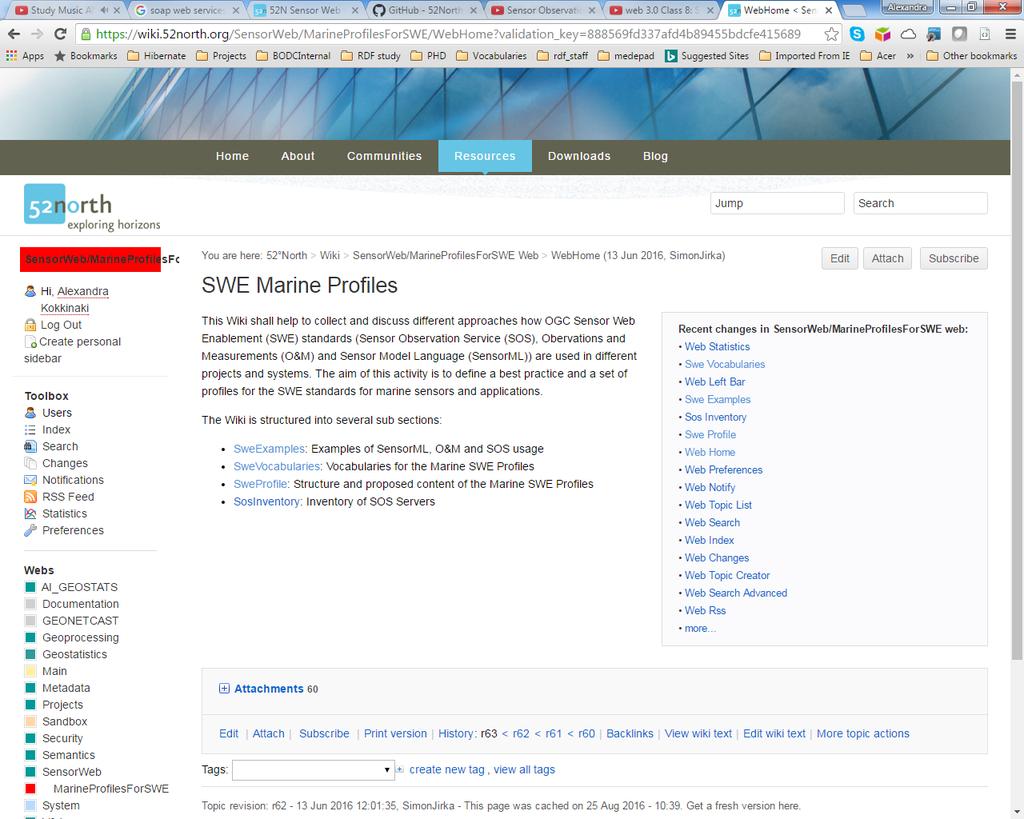
11 Marine Community SWE Marine Profiles 52 North Wiki for SWE Marine Profiles National Environmental Research Council (NERC) Vocabulary Server 2.0
12 SWE Marine profiles Group by partners from several projects and initiatives (AODN, BRIDGES, ENVRI+, EUROFLEETS /EUROFLEETS2, FixO3, FRAM, IOOS, Jerico/Jerico-Next, NeXOS, ODIP/ODIP II, RITMARE, SeaDataNet, SenseOcean, X-DOMES) Aim at developing marine profiles of OGC SWE standards to serve as a common basis for OGC implementations
13


 provides access to lists of standardized terms machine")
14 Controlled Vocabularies and NVS2.0 Controlled vocabularies: In information science controlled vocabulary is a carefully selected list of words and phrases, which are used to tag units of information (document or work) so that they may be more easily retrieved by a search. NERC Vocabulary Server 2.0 (NVS2.0) provides access to lists of standardized terms machine and human readable W3C Simple Knowledge Organisation System (SKOS), RDF/XML Vocab Search, Vocab editor


15 Classify a Fast repetition rate fluorometer in SensorML to aid the rapid discovery of my sensors <sml:classfication> <sml:classifierlist> <!-- Name of the manufacturer of the Sensor X --> <sml:classifier name= InstrumentType"> <sml:term > definition= " <sml:label>instrument Type</sml:label> <sml:value> </sml:value> </sml:term> </sml:identifier> <sml:identifierlist> </sml:identification> Find sensors that are classified as fluorometers Section: Classification Term: InstrumentType Vocabulary: NVS2.0 Value: L05::353
16 Term values Observable property: NVS2.0 Vocabulary P01, P07 Instrument Type: NVS2.0 Vocabulary L05 Platform Type: NVS2.0 Vocabulary L06 Sensor Models: NVS2.0 Vocabulary L22 Roles: NVS2.0 Vocabularies G04, C86 Feature of Interest: NVS2.0 Vocabulary C19 Manufacturer: NVS2.0 Vocabularies L35, C75
17 Term Definitions: Initial Process Collected terms from the SWE examples SWE Marine wiki Identified common terms under each section containing title, definition, alt label Post on the wiki Members add/suggest corrections on the wiki Revised and submit to the VMG Published on the web

18 SensorML Identification Classification Keywords Capabilities Characteristics History References Application domain Instrument Type Accuracy Data storage Calibration Data scientist Call Sign Platform Type Damping ratio Height Decommissioning Manufacturer ICES code Detection limit Housing material Delivery Operator Wiki SWE examples Long name Frequency Length Deployment Owner Member post on the wiki Manufacturer Measurement range Weight Failure PI SSN ontology Model name Operating depth Width LoanEnd Technical Coordinator SensorML examples Model Number Precision LoanStart OpenGIS SensorML Implementation Specification Serial number Resolution Loss Short name Response time Maintenance UUID Selectivity Recovery Unique ID Sensitivity RepairEnd Version Survival depth RepairStart WMO platform number Upgrade
19 NVS collections for SensorML Each SensorML section constitutes a vocabulary=collection in NVS Described in SKOS and RDF/XML Holds a unique URI URI pattern: Each Collection consists of several terms=concepts Each term Holds a unique URI Resolves to RDF/XML URI pattern:
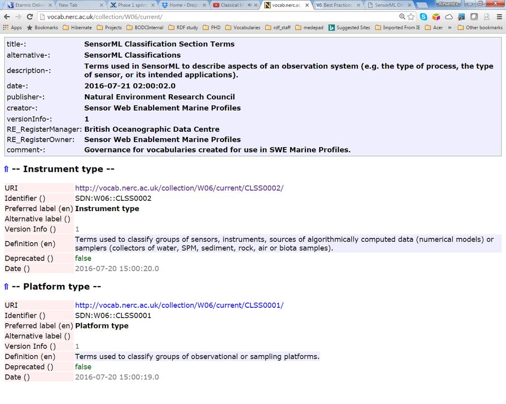

20
21 URI T itle SensorML History Event Types SensorML Capability Section Term s SensorML Characteristic Section Term s SensorML Classification Section Term s SensorML Identification Section Term s SensorML Contact Section Term s
22 Process Member posts on the wiki a suggestion/correction under a section containing a title and a definition If other members do not disagree or Agree it is submitted for revision Revised and posted on the wiki to get final agreement Submitted to the VMG and published on the web (alt label)
23 Where next.. External mappings to the SensorML ontology Internal mappings to NVS2.0 terms Process a list of terms that have been added on the wiki
24 Conclusions SensorML s soft typing characteristic different versions of sensor descriptions not interoperable less discoverable Formalization of the required terms Publication in the form of controlled vocabularies served by NVS2.0 governed by group maintained by British Oceanographic Data Centre (BODC)
25 Acknowledgment This work is funded by the European projects SenseOCEAN (FP7/ under grant agreement No ) Bridges (European Union's Horizon 2020 research and innovation programme under grant agreement No ) Supported Ocean Data Interoperability Platform (ODIP) Supported by the National Environmental Research Council (NERC) National Capability (NC) funding for NC-services, facilities and data (NC-SFD).
26 Useful Links NVS2.0 SOAP service: NVS2.0 RESTFul interface NVS2.0 SPARQL endpoint NVS2.0 SensorML collections

27
Observation trends: Expectations from European Comission regarding data exchange and interoperability
 Observation trends: Expectations from European Comission regarding data exchange and interoperability Marcin Wichorowski (IO PAN), Sławomir Sagan (IO PAN), Declan Dunne (UCC MaREI), John Barton (UCC-TYNDALL)
Towards a pan-european infrastructure for marine and ocean data management + Importance of standards
 Towards a pan-european infrastructure for marine and ocean data management + Importance of standards By Dick M.A. Schaap MARIS Technical Coordinator SeaDataNet & ODIP Coordinator EMODnet Bathymetry Münster
Interoperability in Science Data: Stories from the Trenches
 Interoperability in Science Data: Stories from the Trenches Karen Stocks University of California San Diego Open Data for Open Science Data Interoperability Microsoft escience Workshop 2012 Interoperability
Interoperability Between GRDC's Data Holding And The GEOSS Infrastructure
 City University of New York (CUNY) CUNY Academic Works International Conference on Hydroinformatics 8-1-2014 Interoperability Between GRDC's Data Holding And The GEOSS Infrastructure Volker Andres Henning
Monitoring the Environment with Sensor Web Services
 EnviroInfo 2009 (Berlin) Environmental Informatics and Industrial Environmental Protection: Concepts, Methods and Tools Monitoring the Environment with Sensor Web Services Simon Jirka 1, Dr. Albert Remke
Reducing Consumer Uncertainty
 Spatial Analytics Reducing Consumer Uncertainty Towards an Ontology for Geospatial User-centric Metadata Introduction Cooperative Research Centre for Spatial Information (CRCSI) in Australia Communicate
The UK Marine Environmental Data and Information Network MEDIN
 The UK Marine Environmental Data and Information Network MEDIN M. Charlesworth, R. Lowry, H. Freeman, J. Rapaport, B Seeley Content MEDIN - a brief overview for context Discovery Metadata Standard and
EUDAT B2FIND A Cross-Discipline Metadata Service and Discovery Portal
 EUDAT B2FIND A Cross-Discipline Metadata Service and Discovery Portal Heinrich Widmann, DKRZ DI4R 2016, Krakow, 28 September 2016 www.eudat.eu EUDAT receives funding from the European Union's Horizon 2020
Semantic Sensor Networks XG Semantic Markup Laurent Lefort, CSIRO ICT Centre
 Semantic Sensor Networks XG Semantic Markup Laurent Lefort, CSIRO ICT Centre SSN XG Meeting 3 March 2010 Contents Review of semantic annotation techniques Types of annotations Compatibility of existing
Metadata for Data Discovery: The NERC Data Catalogue Service. Steve Donegan
 Metadata for Data Discovery: The NERC Data Catalogue Service Steve Donegan Introduction NERC, Science and Data Centres NERC Discovery Metadata The Data Catalogue Service NERC Data Services Case study:
Deliverable Initial Data Management Plan
 EU H2020 Research and Innovation Project HOBBIT Holistic Benchmarking of Big Linked Data Project Number: 688227 Start Date of Project: 01/12/2015 Duration: 36 months Deliverable 8.5.1 Initial Data Management
Data is the new Oil (Ann Winblad)
") Data is the new Oil (Ann Winblad) Keith G Jeffery keith.jeffery@keithgjefferyconsultants.co.uk 20140415-16 JRC Workshop Big Open Data Keith G Jeffery 1 Data is the New Oil Like oil has been, data is Abundant
Data is the new Oil (Ann Winblad) Keith G Jeffery keith.jeffery@keithgjefferyconsultants.co.uk 20140415-16 JRC Workshop Big Open Data Keith G Jeffery 1 Data is the New Oil Like oil has been, data is Abundant
Deliverable Final Data Management Plan
 EU H2020 Research and Innovation Project HOBBIT Holistic Benchmarking of Big Linked Data Project Number: 688227 Start Date of Project: 01/12/2015 Duration: 36 months Deliverable 8.5.3 Final Data Management
HANDLING PUBLICLY GENERATED AIR QUALITY DATA PETE TENEBRUSO & MIKE MATSKO MARCH 8 TH, 2017
 HANDLING PUBLICLY GENERATED AIR QUALITY DATA PETE TENEBRUSO & MIKE MATSKO MARCH 8 TH, 2017 EXAMPLES OF DEP DATA AND CROWDSOURCING Storm Readiness Beach Assessments Park Closings Emergency Management Social
Project title: Strengthening the cooperation between the US and the EU in the field of environmental research infrastructures
 Kick off meeting - REPORT Deliverable 4.2 Gap Analysis Report Grant Agreement number: 312118 Project acronym: COOPEUS Project title: Strengthening the cooperation between the US and the EU in the field
Semantic web based Sensor Planning Services (SPS) for Sensor Web Enablement (SWE)
 for Sensor Web Enablement (SWE)") Semantic web based Sensor Planning Services (SPS) for Sensor Web Enablement (SWE) P.Udayakumar 1, M.Indhumathi 2 1 Teaching Fellow,Department of Computer Technology, MIT Campus, Anna University Chennai,
Semantic web based Sensor Planning Services (SPS) for Sensor Web Enablement (SWE) P.Udayakumar 1, M.Indhumathi 2 1 Teaching Fellow,Department of Computer Technology, MIT Campus, Anna University Chennai,
Collaborative Ocean Resource Interoperability: Multi-use of Ocean Data on the Semantic Web
 Collaborative Ocean Resource Interoperability: Multi-use of Ocean Data on the Semantic Web Feng (Barry) Tao, Jon Campbell, Maureen Pagnani, and Gwyn Griffiths National Oceanography Centre Southampton,
Semantic Web: Core Concepts and Mechanisms. MMI ORR Ontology Registry and Repository
 Semantic Web: Core Concepts and Mechanisms MMI ORR Ontology Registry and Repository Carlos A. Rueda Monterey Bay Aquarium Research Institute Moss Landing, CA ESIP 2016 Summer meeting What s all this about?!
Enrichment of Sensor Descriptions and Measurements Using Semantic Technologies. Student: Alexandra Moraru Mentor: Prof. Dr.
 Enrichment of Sensor Descriptions and Measurements Using Semantic Technologies Student: Alexandra Moraru Mentor: Prof. Dr. Dunja Mladenić Environmental Monitoring automation Traffic Monitoring integration
eresearch Collaboration across the Pacific:
 eresearch Collaboration across the Pacific: Marine Systems and Australian Marine Science Craig Johnson University of Tasmania Outline Introduce the Australian Ocean Network Possibilities for trans-pacific
Web Service Interface. Dr. Simon Jirka
 1 Web Service Interface Standards Dr. Simon Jirka Overview 2 Providing Access to Observation Data OGC Sensor Observation Service Controlling Sensors OGC Sensor Planning Service Event Notification SOS 3
THE ENVIRONMENTAL OBSERVATION WEB AND ITS SERVICE APPLICATIONS WITHIN THE FUTURE INTERNET Project introduction and technical foundations (I)
") ENVIROfying the Future Internet THE ENVIRONMENTAL OBSERVATION WEB AND ITS SERVICE APPLICATIONS WITHIN THE FUTURE INTERNET Project introduction and technical foundations (I) INSPIRE Conference Firenze,
ENVIROfying the Future Internet THE ENVIRONMENTAL OBSERVATION WEB AND ITS SERVICE APPLICATIONS WITHIN THE FUTURE INTERNET Project introduction and technical foundations (I) INSPIRE Conference Firenze,
Reducing Consumer Uncertainty Towards a Vocabulary for User-centric Geospatial Metadata
 Meeting Host Supporting Partner Meeting Sponsors Reducing Consumer Uncertainty Towards a Vocabulary for User-centric Geospatial Metadata 105th OGC Technical Committee Palmerston North, New Zealand Dr.
Deliverable 6.4. Initial Data Management Plan. RINGO (GA no ) PUBLIC; R. Readiness of ICOS for Necessities of integrated Global Observations
 PUBLIC; R. Readiness of ICOS for Necessities of integrated Global Observations") Ref. Ares(2017)3291958-30/06/2017 Readiness of ICOS for Necessities of integrated Global Observations Deliverable 6.4 Initial Data Management Plan RINGO (GA no 730944) PUBLIC; R RINGO D6.5, Initial Risk
Ref. Ares(2017)3291958-30/06/2017 Readiness of ICOS for Necessities of integrated Global Observations Deliverable 6.4 Initial Data Management Plan RINGO (GA no 730944) PUBLIC; R RINGO D6.5, Initial Risk
Geo Seas A pan European infrastructure for the management of marine geological and geophysical data
 Geo Seas A pan European infrastructure for the management of marine geological and geophysical data Colin Graham (BGS), Dick Schaap (MARIS), Paolo Diviacco (OGS) & Helen Glaves (BGS) Integrated Infrastructure
Unlocking the full potential of location-based services: Linked Data driven Web APIs
 Unlocking the full potential of location-based services: Linked Data driven Web APIs Open Standards for Linked Organisations about Raf Buyle Ziggy Vanlishout www.vlaanderen.be/informatievlaanderen 6.4
Sensor Data Management
 Wright State University CORE Scholar Kno.e.sis Publications The Ohio Center of Excellence in Knowledge- Enabled Computing (Kno.e.sis) 8-14-2007 Sensor Data Management Cory Andrew Henson Wright State University
EUDAT-B2FIND A FAIR and Interdisciplinary Discovery Portal for Research Data
 EUDAT-B2FIND A FAIR and Interdisciplinary Discovery Portal for Research Data Heinrich Widmann, DKRZ Claudia Martens, DKRZ Open Science Days, Berlin, 17 October 2017 www.eudat.eu EUDAT receives funding
INTEROPERABILITY + SEMANTICS = CHECK! Smart and Cost Effective Data Modelling and Tools of the Future
 INTEROPERABILITY + SEMANTICS = CHECK! Smart and Cost Effective Data Modelling and Tools of the Future Miika Alonen, CSC IT Center for Science Suvi Remes, CSC IT Center for Science Patrik Maltusch, Aalto
The Semantic Sensor Network Ontology A Generic Language to Describe Sensor Assets
 Ben Ridge Road Weather Station, South Esk River Catchment, Tasmania The Semantic Sensor Network Ontology A Generic Language to Describe Sensor Assets Holger Neuhaus Michael Compton Commonwealth Scientific
Why CERIF? Keith G Jeffery Scientific Coordinator ERCIM Anne Assserson eurocris. Keith G Jeffery SDSVoc Workshop Amsterdam
 A Europe-wide Interoperable Virtual Research Environment to Empower Multidisciplinary Research Communities and Accelerate Innovation and Collaboration Why CERIF? Keith G Jeffery Scientific Coordinator
Terminologies, Knowledge Organization Systems, Ontologies
 Terminologies, Knowledge Organization Systems, Ontologies Gerhard Budin University of Vienna TSS July 2012, Vienna Motivation and Purpose Knowledge Organization Systems In this unit of TSS 12, we focus
Soumya Kanti Datta Research Engineer
 Testing Semantic Interoperability Soumya Kanti Datta Research Engineer Email dattas@eurecom.fr 22/03/2018 Testing Semantic Inteoperability 2 Roadmap Introduction Testing Semantic Interop Survey Conclusion
Linked Open Data Cloud. John P. McCrae, Thierry Declerck
 Linked Open Data Cloud John P. McCrae, Thierry Declerck Hitchhiker s guide to the Linked Open Data Cloud DBpedia Largest node in the linked open data cloud Nucleus for a web of open data Most data is
Heterogeneous Missions Accessibility: Interoperability for Earth Observation
 Heterogeneous Missions Accessibility: Interoperability for Earth Observation Pier Giorgio Marchetti - European Space Agency pier.giorgio.marchetti@esa.int Slide 1 EO missions Earth Explorer Global Challenges
From Open Data to Data- Intensive Science through CERIF
 From Open Data to Data- Intensive Science through CERIF Keith G Jeffery a, Anne Asserson b, Nikos Houssos c, Valerie Brasse d, Brigitte Jörg e a Keith G Jeffery Consultants, Shrivenham, SN6 8AH, U, b University
Building a missing item in INSPIRE: The Re3gistry
 Building a missing item in INSPIRE: The Re3gistry www.jrc.ec.europa.eu Serving society Stimulating innovation Supporting legislation Key pillars of data interoperability Conceptual data models Encoding
Towards an Integrated Information Framework for Service Technicians
 Towards an Integrated Information Framework for Service Technicians Sebastian Bader, Jan Oevermann KIT The Research University in the Helmholtz Association www.kit.edu How it should be: I need to do maintenance
Long-term preservation for INSPIRE: a metadata framework and geo-portal implementation
 Long-term preservation for INSPIRE: a metadata framework and geo-portal implementation INSPIRE 2010, KRAKOW Dr. Arif Shaon, Dr. Andrew Woolf (e-science, Science and Technology Facilities Council, UK) 3
European Marine Data Exchange
 European Marine Data Exchange By Dick M.A. Schaap MARIS (NL) EU SeaDataNet Technical Coordinator EU EMODnet Ingestion Coordinator Noordzeedagen 2018 - October 2018 Acquisition of ocean and marine data
Jeffery S. Horsburgh. Utah Water Research Laboratory Utah State University
 Advancing a Services Oriented Architecture for Sharing Hydrologic Data Jeffery S. Horsburgh Utah Water Research Laboratory Utah State University D.G. Tarboton, D.R. Maidment, I. Zaslavsky, D.P. Ames, J.L.
Leveraging metadata standards in ArcGIS to support Interoperability. David Danko and Aleta Vienneau
 Leveraging metadata standards in ArcGIS to support Interoperability David Danko and Aleta Vienneau Leveraging Metadata Standards in ArcGIS for Interoperability Why metadata and metadata standards? Overview
SeaDataNet, Pan-European infrastructure for marine ands ocean data management + EMODNET Preparatory Action Hydrographic and Seabed Mapping
 SeaDataNet, Pan-European infrastructure for marine ands ocean data management + EMODNET Preparatory Action Hydrographic and Seabed Mapping By Dick M.A. Schaap Technical Coordinator SeaDataNet & Coordinator
Open Geospatial Consortium Inc.
 Open Geospatial Consortium Inc. Date: 2010-02-15 Reference number of this OpenGIS Project Document: Version: 0.0.1 Category: OpenGIS Interface Standard Editor: Peter Baumann WCS 2.0 Extension -- XML/POST
Knowledge Inventory for hydrogeology research
 Knowledge Inventory for hydrogeology research This project has received funding from the European Union s Horizon 2020 research and innovation programme under grant agreement No 642047. REDIAM Environmental
University of Bath. Publication date: Document Version Publisher's PDF, also known as Version of record. Link to publication
 Citation for published version: Patel, M & Duke, M 2004, 'Knowledge Discovery in an Agents Environment' Paper presented at European Semantic Web Symposium 2004, Heraklion, Crete, UK United Kingdom, 9/05/04-11/05/04,.
EMODnet Bathymetry. By Dick M.A. Schaap Coordinator. 20 th April 2016, EGU 2016, Vienna - Austria
 EMODnet Bathymetry By Dick M.A. Schaap Coordinator 20 th April 2016, EGU 2016, Vienna - Austria EMODNet Bathymetry Ongoing in 3 consecutive projects since 2009 with expanding consortium (at present >30
INSPIRE Download Service
 The OGC SOS as INSPIRE Download Service for (meteorological) l) Observation Data Simon Jirka (52 North) 29 th October 2014 5th Workshop on the use of GIS/OGC standards in meteorology Offenbach (Germany)
1. CONCEPTUAL MODEL 1.1 DOMAIN MODEL 1.2 UML DIAGRAM
 1 1. CONCEPTUAL MODEL 1.1 DOMAIN MODEL In the context of federation of repositories of Semantic Interoperability s, a number of entities are relevant. The primary entities to be described by ADMS are the
Glossary of Exchange Network Related Groups
 Glossary of Exchange Network Related Groups CDX Central Data Exchange EPA's Central Data Exchange (CDX) is the point of entry on the National Environmental Information Exchange Network (Exchange Network)
FIBO Metadata in Ontology Mapping
 FIBO Metadata in Ontology Mapping For Open Ontology Repository OOR Metadata Workshop VIII 02 July 2013 Copyright 2010 EDM Council Inc. 1 Overview The Financial Industry Business Ontology Introduction FIBO
For each use case, the business need, usage scenario and derived requirements are stated. 1.1 USE CASE 1: EXPLORE AND SEARCH FOR SEMANTIC ASSESTS
 1 1. USE CASES For each use case, the business need, usage scenario and derived requirements are stated. 1.1 USE CASE 1: EXPLORE AND SEARCH FOR SEMANTIC ASSESTS Business need: Users need to be able to
Towards a pan-european infrastructure for marine and ocean data management + Importance of standards
 Towards a pan-european infrastructure for marine and ocean data management + Importance of standards By Dick M.A. Schaap Technical Coordinator SeaDataNet & Coordinator EMODnet Bathymetry Hydrography Day,
Extending SOA Infrastructure for Semantic Interoperability
 Extending SOA Infrastructure for Semantic Interoperability Wen Zhu wzhu@alionscience.com ITEA System of Systems Conference 26 Jan 2006 www.alionscience.com/semantic Agenda Background Semantic Mediation
Semantic Infrastructure and Platforms for Geospatial Services: A report from European Projects 4 th International Workshop on Semantic and
 Semantic Infrastructure and Platforms for Geospatial Services: A report from European Projects 4 th International Workshop on Semantic and Conceptual Issues in GIS (SeCoGIS 2010) Vancouver, Canada November
Dictionary Driven Exchange Content Assembly Blueprints
 Dictionary Driven Exchange Content Assembly Blueprints Concepts, Procedures and Techniques (CAM Content Assembly Mechanism Specification) Author: David RR Webber Chair OASIS CAM TC January, 2010 http://www.oasis-open.org/committees/cam
RDF and Digital Libraries
 RDF and Digital Libraries Conventions for Resource Description in the Internet Commons Stuart Weibel purl.org/net/weibel December 1998 Outline of Today s Talk Motivations for developing new conventions
EUDAT and Cloud Services
 EUDAT and Cloud Services Space Data & Cloud Computing Infrastructures: Policies and Regulations ESRIN, Frascati, 7 July 2017 Per Öster CSC-IT Center for Science Finland www.eudat.eu EUDAT receives funding
References: Conclusions. Excerpts from Instrument Interface Standards for Interoperable Ocean Sensor Networks. Transducer Electronic Data Sheet (TEDS)
") Fig.11 - Block Diagram of the Test Bench Conclusions PUCK Protocol can co-exist and it is compatible with other existing standards as IEEE1451 or SWE SOS. The use of PUCK protocol with in an instrument
Fig.11 - Block Diagram of the Test Bench Conclusions PUCK Protocol can co-exist and it is compatible with other existing standards as IEEE1451 or SWE SOS. The use of PUCK protocol with in an instrument
The European Commission s science and knowledge service. Joint Research Centre
 The European Commission s science and knowledge service Joint Research Centre GeoDCAT-AP The story so far Andrea Perego, Antonio Rotundo, Lieven Raes GeoDCAT-AP Webinar 6 June 2018 What is GeoDCAT-AP Geospatial
Semantic Web for Earth and Environmental Terminology (SWEET) Status, Future Development and Community Building
 Status, Future Development and Community Building") Semantic Web for Earth and Environmental Terminology (SWEET) 2018 Status, Future Development and Community Building 2 Agenda and Purpose Current status of SWEET e.g. What has the community been doing?
Semantic Web for Earth and Environmental Terminology (SWEET) 2018 Status, Future Development and Community Building 2 Agenda and Purpose Current status of SWEET e.g. What has the community been doing?
Open Geospatial Consortium Inc.
 Open Geospatial Consortium Inc. Date: 2010-02-15 Reference number of this OpenGIS Project Document: OGC 09-147 Version: 0.0.1 Category: OpenGIS Interface Standard Editor: Peter Baumann WCS Extension --
DATA MANAGEMENT PLANS Requirements and Recommendations for H2020 Projects. Matthias Razum April 20, 2018
 DATA MANAGEMENT PLANS Requirements and Recommendations for H2020 Projects Matthias Razum April 20, 2018 DATA MANAGEMENT PLANS (DMP) typically state what data will be created and how, outline the plans
Design & Manage Persistent URIs
 Training Module 2.3 OPEN DATA SUPPORT Design & Manage Persistent URIs PwC firms help organisations and individuals create the value they re looking for. We re a network of firms in 158 countries with close
Motions from the 91st OGC Technical and Planning Committee Meetings Geneva, Switzerland Contents
 Motions from the 91st OGC Technical and Planning Committee Meetings Geneva, Switzerland Contents "The Open Geospatial Consortium and EarthCube White Paper... 2 Vote for OGC Sensor Observation Service 2.0
Open Geospatial Consortium
 Open Geospatial Consortium Date: 2010-10-27 Reference number of this OpenGIS Project Document: Version: 1.0.0 Category: OpenGIS Interface Standard Editor: Peter Baumann OGC Web Coverage Service 2.0 Interface
EXTRA Examples of OGC standards in support of health applications
 EXTRA Examples of OGC standards in support of health applications Some prior / existing initiatives using OGC Standards EU INSPIRE (health and safety working group) GEOSS AIP, EO2Heaven project: EO2HEAVEN
SKOS Standards and Best Practises for USING Knowledge Organisation Systems ON THE Semantic Web
 NKOS workshop ECDL Bath 2004-09-16 SKOS Standards and Best Practises for USING Knowledge Organisation Systems ON THE Semantic Web Rutherford Appleton Laboratory Overview Intro SKOS Core SKOS API SKOS Mapping
SEXTANT 1. Purpose of the Application
 SEXTANT 1. Purpose of the Application Sextant has been used in the domains of Earth Observation and Environment by presenting its browsing and visualization capabilities using a number of link geospatial
Best Practices for Structuring Content and Integrating e-learning and e-textbooks
 Best Practices for Structuring Content and Integrating e-learning and e-textbooks The Publisher Perspective Paul Belfanti Pearson Education North America Director of Content Architecture May 30, 2013 Business
Open Geospatial Consortium
 Open Geospatial Consortium Date: 2010-10-12 Reference number of this document: Category: Public Discussion Paper Editor(s): Simon Jirka, Arne Bröring, Daniel Nüst OGC Sensor Observable Registry (SOR) Discussion
ISA Action 1.17: A Reusable INSPIRE Reference Platform (ARE3NA)
") ISA Action 1.17: A Reusable INSPIRE Reference Platform (ARE3NA) Expert contract supporting the Study on RDF and PIDs for INSPIRE Deliverable D.EC.3.2 RDF in INSPIRE Open issues, tools, and implications
ISA Action 1.17: A Reusable INSPIRE Reference Platform (ARE3NA) Expert contract supporting the Study on RDF and PIDs for INSPIRE Deliverable D.EC.3.2 RDF in INSPIRE Open issues, tools, and implications
GeoDCAT-AP Representing geographic metadata by using the "DCAT application profile for data portals in Europe"
 GeoDCAT-AP Representing geographic metadata by using the "DCAT application profile for data portals in Europe" Andrea Perego, Vlado Cetl, Anders Friis-Christensen, Michael Lutz, Lorena Hernandez Joint
DMAC Report to the GCOOS BOD. GCOOS Board of Directors Meeting Biloxi, MS February 2008
 DMAC Report to the GCOOS BOD GCOOS Board of Directors Meeting Biloxi, MS 26-27 February 2008 GCOOS DMAC Membership 2008 Steve Anderson - Horizon Marine! Brenda Babin - LUMCON! Steve Beaudet - SAIC! Julie
Extension of INSPIRE Download Services TG for Observation Data
 Extension of INSPIRE Download Services TG for Observation Data Simon Jirka (52 North) 14 th June 2014, MIG Workshop on WCS-based INSPIRE Download Services Agenda Motivation Sensor Web Proposed Update for
Semantic Web. Tahani Aljehani
 Semantic Web Tahani Aljehani Motivation: Example 1 You are interested in SOAP Web architecture Use your favorite search engine to find the articles about SOAP Keywords-based search You'll get lots of information,
Content Enrichment. An essential strategic capability for every publisher. Enriched content. Delivered.
 Content Enrichment An essential strategic capability for every publisher Enriched content. Delivered. An essential strategic capability for every publisher Overview Content is at the centre of everything
Novel System Architectures for Semantic Based Sensor Networks Integraion
 Novel System Architectures for Semantic Based Sensor Networks Integraion Z O R A N B A B O V I C, Z B A B O V I C @ E T F. R S V E L J K O M I L U T N O V I C, V M @ E T F. R S T H E S C H O O L O F T
Introduction of SeaDataNet and EMODNET Working towards a harmonised data infrastructure for marine data. Peter Thijsse MARIS
 Introduction of SeaDataNet and EMODNET Working towards a harmonised data infrastructure for marine data Peter Thijsse MARIS CLIPC & IS-ENES 2 workshop, KNMI, November 2014 Outline 1. Introduction to marine
Workshop 2. > Interoperability <
 Workshop 2 21 / 08 / 2011 > Interoperability < Heiko Zimmermann R&D Engineer, AHI CR Santec Heiko.Zimmermann@tudor.lu Interoperability definition Picture from NCI-Wiki (https://wiki.nci.nih.gov) 2 Interoperability
The MEG Metadata Schemas Registry Schemas and Ontologies: building a Semantic Infrastructure for GRIDs and digital libraries Edinburgh, 16 May 2003
 The MEG Metadata Schemas Registry Schemas and Ontologies: building a Semantic Infrastructure for GRIDs and digital libraries Edinburgh, 16 May 2003 Pete Johnston UKOLN, University of Bath Bath, BA2 7AY
Standardizing ontologies for the IP traffic measurement
 Standardizing ontologies for the IP traffic measurement Angel Ferreiro (olivo@tid.es) Telefonica I+D Future Network Technologies Workshop 10-11 March 2010 -ETSI, Sophia Antipolis,France Rationale Several
BIBLIOGRAPHIC REFERENCE DATA STANDARD
 BIBLIOGRPHIC REFERENCE DT STNDRD Standard No.: EX000007.1 January 6, 2006 This standard has been produced through the Environmental Data Standards Council (EDSC). The Environmental Data Standards Council
Data discovery and access via the SeaDataNet CDI system
 Data discovery and access via the SeaDataNet CDI system Central dataproducts and data services on distributed data. Peter Thijsse MARIS CLIPC IS-ENES workshop, KNMI, November 2014 Outline 1. Introduction
A Review for Semantic Sensor Web Research and Applications
 , pp.31-36 http://dx.doi.org/10.14257/astl.2014.48.06 A Review for Semantic Sensor Web Research and Applications Chaoqun Ji, Jin Liu, Xiaofeng Wang College of Information Engineering, Shanghai Maritime
Making Open Data work for Europe
 Making Open Data work for Europe Daniele Rizzi European Commission DG Communications Networks, Content and Technology daniele.rizzi@ec.europa.eu Nikolaos Loutas PwC EU Services nikolaos.loutas@be.pwc.com
SeaDataNet, Pan-European infrastructure for ocean and marine data management & EMODNET Preparatory Actions Hydrographic Lot
 SeaDataNet, Pan-European infrastructure for ocean and marine data management & EMODNET Preparatory Actions Hydrographic Lot By Dick M.A. Schaap MARIS Brest, Sept 2009, GEBCO Science Day Supported by the
Linking ITSM and SOA a synergetic fusion
 Linking ITSM and SOA a synergetic fusion Dimitris Dranidis dranidis@city.academic.gr CITY College, Computer Science Department South East European Research Centre (SEERC) CITY College CITY College Founded
European Interoperability Reference Architecture (EIRA) overview
 overview") European Interoperability Reference Architecture (EIRA) overview Version 0.8.3 beta 09/01/2015 ISA Action 2.1: European Interoperability Architecture Specific Contract N. 54 Framework contract N. DI/07171
European Interoperability Reference Architecture (EIRA) overview Version 0.8.3 beta 09/01/2015 ISA Action 2.1: European Interoperability Architecture Specific Contract N. 54 Framework contract N. DI/07171
Network Working Group Request for Comments: 5138 Category: Informational February 2008
 Network Working Group S. Cox Request for Comments: 5138 CSIRO Category: Informational February 2008 A Uniform Resource Name (URN) Namespace for the Commission for the Management and Application of Geoscience
Metadata Workshop 3 March 2006 Part 1
 Metadata Workshop 3 March 2006 Part 1 Metadata overview and guidelines Amelia Breytenbach Ria Groenewald What metadata is Overview Types of metadata and their importance How metadata is stored, what metadata
INSPIRE & Environment Data in the EU
 INSPIRE & Environment Data in the EU Andrea Perego Research Data infrastructures for Environmental related Societal Challenges Workshop @ pre-rda P6 Workshops, Paris 22 September 2015 INSPIRE in a nutshell
Rolling Deck to Repository: Opportunities for US-EU Collaboration
 Rolling Deck to Repository: Opportunities for US-EU Collaboration Stephen Miller Scripps Institution of Oceanography La Jolla, California USA http://gdc.ucsd.edu Co-authors: Helen Glaves British Geological
Summary of Bird and Simons Best Practices
 Summary of Bird and Simons Best Practices 6.1. CONTENT (1) COVERAGE Coverage addresses the comprehensiveness of the language documentation and the comprehensiveness of one s documentation of one s methodology.
Semantic Web Company. PoolParty - Server. PoolParty - Technical White Paper.
 Semantic Web Company PoolParty - Server PoolParty - Technical White Paper http://www.poolparty.biz Table of Contents Introduction... 3 PoolParty Technical Overview... 3 PoolParty Components Overview...
OGC Open Geospatial Consortium (OGC)
") OGC Open Geospatial Consortium (OGC) Request for Quotations (RFQ) and Call for Participation (CFP) for OGC Web Services Initiative - Phase 9 (OWS-9) Annex A OWS-9 WBS and Work Items RFQ Issuance Date:
OGC Open Geospatial Consortium (OGC) Request for Quotations (RFQ) and Call for Participation (CFP) for OGC Web Services Initiative - Phase 9 (OWS-9) Annex A OWS-9 WBS and Work Items RFQ Issuance Date:
Proposed Revisions to ebxml Technical Architecture Specification v ebxml Business Process Project Team
 1 2 3 4 5 6 7 8 9 10 11 12 13 14 15 16 17 18 19 20 21 22 23 24 25 26 27 28 29 30 31 32 33 Proposed Revisions to ebxml Technical Architecture Specification v1.0.4 ebxml Business Process Project Team 11
Digital repositories as research infrastructure: a UK perspective
 Digital repositories as research infrastructure: a UK perspective Dr Liz Lyon Director This work is licensed under a Creative Commons Licence Attribution-ShareAlike 2.0 UKOLN is supported by: Presentation
INSPIRE status report
 INSPIRE Team INSPIRE Status report 29/10/2010 Page 1 of 7 INSPIRE status report Table of contents 1 INTRODUCTION... 1 2 INSPIRE STATUS... 2 2.1 BACKGROUND AND RATIONAL... 2 2.2 STAKEHOLDER PARTICIPATION...
How to use Water Data to Produce Knowledge: Data Sharing with the CUAHSI Water Data Center
 How to use Water Data to Produce Knowledge: Data Sharing with the CUAHSI Water Data Center Jon Pollak The Consortium of Universities for the Advancement of Hydrologic Science, Inc. (CUAHSI) August 20,