ArcGIS Desktop: Fundamentals of Cartography
|
|
|
- Miranda Rose
- 6 years ago
- Views:
Transcription

1 ArcGIS Desktop: Fundamentals of Cartography
2 Outline Symbology Style Files -.style Layer files -.lyr Labeling Label Classes Label Expressions Map Document files -.mxd Map Template files -.mxt Map Elements Grids and Graticules Extent Rectangles Printing Exporting

3 Let s Make This Map


4 Demonstration
 Symbols (objects) Can have multiple symbols and map elements")
5 Style File -.style A Style File stores: Map elements (graphics) Symbols (objects) Can have multiple symbols and map elements Most commonly used ESRI symbols IS NOT dependant on Data Can be accessed through Tools>Styles>Style Manager


6 Definition Queries Use Queries to clean-up or focus your map Data shown in the map should support the map theme Not necessary to export a sub set of data The query may change based upon scale
7 Demonstration

8 Layer File -.lyr A Layer File stores: Definition queries Symbology Labeling Joins and Relates Transparency Can be created for any layer in your TOC A layer file is DEPENDENT on data The data must be stored in the EXACT path that the layer file contains

9 Layer Symbology There are 5 thematic methods to classify a layer Features Categories Quantities Charts Multiple Attributes
")

")

10 Displaying Qualitative (text) Values Features (ArcMap Default) Draw all features using the same symbol Where are features located? Categories Draw categories using unique values from a field(s) Where are features located and what category or group do they belong to?
 Values")


11 Displaying Quantitative (numeric) Values Quantities Draw features based upon counts, amounts, ratios, or ranked values How much of something? Charts Display a number of related numeric attributes for comparison
12 Demonstration

13 Label Manager Access it from the Label Toolbar Same functionality as going to a layers properties>label Pause Labels


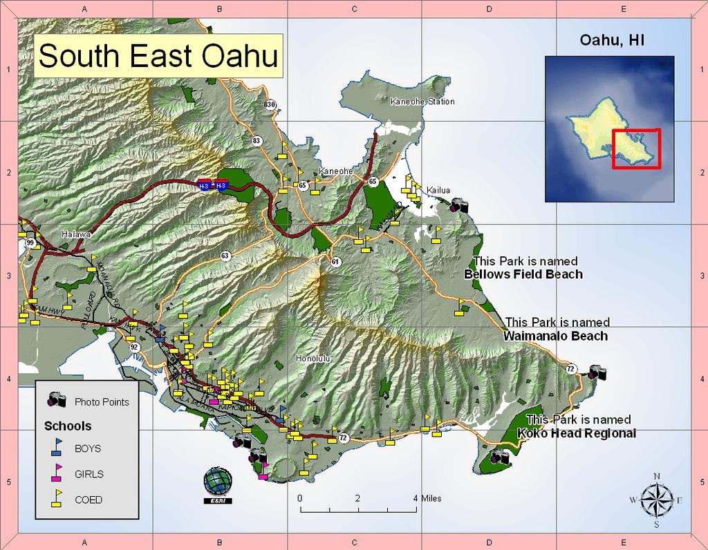
14 Labeling Features Label Expressions Use the Help Button! Contains many of the common scripts With Label Expressions you can: Add Text and Symbols Concatenate Fields Stack Fields Format Text Example: "This Park is named" &vbnewline& "<BOL>"&(Left( [NAME], Len( [NAME])-4))&"</BOL>"

15 Map Document File -.mxd A Map Document stores: Symbology Toolbar Location Custom Buttons Custom Code (triggers) Start up location Map Elements

16 Saving a.mxd There are 3 menu options to save an.mxd The Save Button Saves the current document as an.mxd The Save As Command Saves the current document as an.mxd or.mxt with a different name or file location The Save A Copy Command Saves the current map document to a previous version of ArcMap or saves a copy of the current document as a.mxd or.mxt

17 Map Template File -.mxt A Map Template stores: Symbology Toolbar Location Custom Buttons Custom Code (triggers) Start up location Map Elements

18 Creating Custom Template Tabs Create new folder in: <ArcGISDirectory>\Bin\Template To preview an.mxt save it with a thumbnail File>Document Properties
19 Demonstration
20 Layout and Data View Layout view shows the virtual page upon which map content and map elements are placed Data view is used for exploring, displaying, querying, editing, and analyzing spatial data

21 Layout View (Virtual Page) Shows all data frames and map elements Legends Data Frames Graticules, grids, and North arrows Rulers Scale bars Text Pictures and graphics

22 Data View (Data Manipulation) Shows only one data frame Analysis Editing Annotation Reports

23 Map Elements Map elements are added in Layout View North Arrow Scale Bar Title Legend Logos Pictures Objects Text Box

24 Legend Transparency Located on the General tab of Data Frame Properties Checked on in 9.3 by default The more transparent the layer the lighter the color Hillshade Value High : 254 Hillshade Value High : 254 Low : 0 Low : 0

25 Titles and Text Elements Text categories: Analytical: charts, tables, graphs Descriptive: feature labels Metadata: projection, author, date Positional: grids, graticules, scale text Legend Projection Title Author, date, and data source information


26 Titles and Text Elements Wrap text into a shape Create text in columns Format text with XML-based tags Use the Draw toolbar to add text to your layout Example: Use the <BOL> xml tag to bold text Draw a graphic shape with the Paragraph Text tool and your text will wrap with the shape


27 Grids and Graticules Three options: Graticules To show Lat and Long Reference Grid (Index Grid) - To divide the map into a specified number of rows or columns Measured Grid To show UTM and State Plane Convert grid to graphic to control draw order of the Grid or Graticule


28 Extent Rectangles and Data Frames You can have multiple extent rectangles San Francisco Clipping the data frame does not alter the actual data or the data frame.
29 Demonstration

30 Page and Print Setup Use Printer Page settings to prevent clipping of map or to match the printer page to the map page Use Scale Map Elements to automatically scale map elements when changing the page sizes Set your page and printing set up before you begin creating your map

31 Printing Printing Engine Windows Printer is best choice for quality and accuracy Output Image Quality is used to resample Raster data Page Tiling Enabled when Use Printer Paper is unchecked and the map size is larger than the page size


32 Exporting CMYK is used to print maps RGB is used to view maps on a monitor Use embedded fonts when exporting to a PDF For web use: JPEG, GIF, PNG, SVG For printing use: PDF, EPS, AI, EMF Eliminate the white margin around your image by turning on the Clip Output To Graphics Extent option
33 Conclusion ArcMap has tools to create organized and visually pleasing maps Map elements Label Manager ArcMap tools help streamline workflow and prevent redundant work.style files.lyr files.mxt files
34 Resources Online ArcGIS 9.3 Desktop Help welcome Search for Page Layout and Map Composition and An Overview of Mapping and Visualization Virtual Campus Training Seminars Making Better Map Layouts with ArcGIS *FREE* Cartographic Design Using ArcGIS 9 The 15-Minute Map: Creating a Basic Map in ArcMap Instructor-Led Classes Introduction to ArcGIS I Introduction to ArcGIS II
ArcGIS Desktop: Making Maps in ArcMap
 ArcGIS Desktop: Making Maps in ArcMap California, Nevada, Hawaii Regional User Group February 6-8, 6 2008 Sacramento, CA Harry J. Moore IV Outline Symbology Style Files -.style Layer files -.lyr Labeling
Review of File Management and Introduction to ArcGIS
 Review of File Management and Introduction to ArcGIS RNR/GEOG 417/517 Overview of Presentation Discuss the objectives of the lab exercise Introduce the class directory structure General file policies Introduce
Chapter 5. Presenting Data
 Chapter 5. Presenting Data Copyright McGraw-Hill Education. Permission required for reproduction or display. 5-1 Map Design Process 5-2 1 About ArcGIS Chapter 5. Presenting Data 5-3 Page layouts and map
Geographical Information Systems Institute. Center for Geographic Analysis, Harvard University. LAB EXERCISE 1: Basic Mapping in ArcMap
 Harvard University Introduction to ArcMap Geographical Information Systems Institute Center for Geographic Analysis, Harvard University LAB EXERCISE 1: Basic Mapping in ArcMap Individual files (lab instructions,
Map Making Tutorial Jennifer Ailshire June 25, Adding Data to the Map and Saving the Map
 Map Making Tutorial Jennifer Ailshire June 25, 2008 Adding Data to the Map and Saving the Map Click on the Add Data button, browse to the appropriate directory and select the desired file(s). After you
USING DATA DRIVEN PAGES
 USING DATA DRIVEN PAGES Mid-West ESRI Utility User s Group Conference March 26, 2014 Presented by: Hillary Bjorstrom, GIS Analyst STAR Energy Services LLC Alexandria, Minnesota EXERCISE 1 CREATING A GRID
Activity: Using Mapbook
 Activity: Using Mapbook Requirements You must have ArcMap for this activity. Preparation: Download Mapbook. The download page is intimidating. Just scroll to the bottom and find the Download Now place.
Mid-West ESRI Utility User s Group Conference. March 26, 2014
 Mid-West ESRI Utility User s Group Conference March 26, 2014 Presented by: Hillary Bjorstrom, GIS Analyst STAR Energy Services LLC 1 What are Data Driven Pages? Data Driven Pages Workflow Creating an Index
ArcGIS ArcMap and Cartography Part 3. Second Screen: Have a cool map open on the second screen and the Washington DC map (minimized).
.") ArcGIS ArcMap and Cartography Part 3 First slide on the screen as people walk in. Second Screen: Have a cool map open on the second screen and the Washington DC map (minimized). 1 Map Composition and Page
ArcGIS ArcMap and Cartography Part 3 First slide on the screen as people walk in. Second Screen: Have a cool map open on the second screen and the Washington DC map (minimized). 1 Map Composition and Page
Advanced PDF features
 1 of 7 2/17/2009 10:56 PM Show Navigation Hide Navigation You are here: Mapping and v isualization > Page layout and map composition > Map output Advanced PDF features Release 9.3 Last modified November
Designing and Using Basemaps. Jennifer Hughey
 Designing and Using Basemaps Jennifer Hughey Agenda The ArcGIS System Basemaps are a key component of your system Cartographic design considerations Using basemap layers in ArcMap Best practices for designing
From Data to Map in 30 Minutes. Aileen Buckley, PhD
 From Data to Map in 30 Minutes Aileen Buckley, PhD This session Crater Lake online map From NPS: https://www.nps.gov/carto/hfc/carto/media/crlamap1.pdf Download Crater Lake map packages here: ArcGIS Pro
Working with PowerPoint. Modify PowerPoint. Views
 Working with PowerPoint The new user interface The Backstage view The Office Ribbon with its tabs The Quick Access Toolbar The Status Bar How to Use Smart Tags The New File Format Live Preview Protected
GIS IN ECOLOGY: CREATING RESEARCH MAPS
 GIS IN ECOLOGY: CREATING RESEARCH MAPS Contents Introduction... 2 Elements of Cartography... 2 Course Data Sources... 3 Tasks... 3 Establishing the Map Document... 3 Laying Out the Map... 5 Exporting Your
Introduction to GIS & Mapping: ArcGIS Desktop
 Introduction to GIS & Mapping: ArcGIS Desktop Your task in this exercise is to determine the best place to build a mixed use facility in Hudson County, NJ. In order to revitalize the community and take
Esri Production Mapping An Introduction
 Esri International User Conference San Diego, California Technical Workshops July 25, 2012 Esri Production Mapping An Introduction Lana Tylka Amber Bethell Workshop Overview Part I - Industry challenges
Session 3: Cartography in ArcGIS. Mapping population data
 Exercise 3: Cartography in ArcGIS Mapping population data Background GIS is well known for its ability to produce high quality maps. ArcGIS provides useful tools that allow you to do this. It is important
Lecture 6 MAP DESIGN: PART II. Map Elements, Cartography, Text, Annotation, Labels and Graphics
 Lecture 6 MAP DESIGN: PART II Map Elements, Cartography, Text, Annotation, Labels and Graphics Outline What is a good map? Things to think about when making a map Design Process Map Elements Labels Annotation
INTRODUCTION TO GIS WORKSHOP EXERCISE
 111 Mulford Hall, College of Natural Resources, UC Berkeley (510) 643-4539 INTRODUCTION TO GIS WORKSHOP EXERCISE This exercise is a survey of some GIS and spatial analysis tools for ecological and natural
Converting AutoCAD Map 2002 Projects to ArcGIS
 Introduction This document outlines the procedures necessary for converting an AutoCAD Map drawing containing topologies to ArcGIS version 9.x and higher. This includes the export of polygon and network
Getting Started with GIS using ArcGIS 10.6 What is GIS? and - Module 1 Creating a map document
 Getting Started with GIS using ArcGIS 10.6 What is GIS? and - Module 1 Creating a map document Marcel Fortin Map & Data Library mdl@library.utoronto.ca 2018 http://mdl.library.utoronto.ca This workshop
Geography 281 Map Making with GIS Project Two: Map Design Issues in ArcMap
 Geography 281 Map Making with GIS Project Two: Map Design Issues in ArcMap This activity provides an introduction to the map design process. It takes you through a typical sequence from the initial decision
In order to follow this set of directions you will need the following
 How to Create Maps & Figures in ArcView 9x In order to follow this set of directions you will need the following 1) the Jenny s Louisiana GIS Instructional CD 2) a computer with ArcGIS on it (version 9.0
Laboratory Topic 3: Creating Charts and a Layout in ArcGIS Creating a Map for Plotting [ LAEP/GEOG c188 ]
![Laboratory Topic 3: Creating Charts and a Layout in ArcGIS Creating a Map for Plotting [ LAEP/GEOG c188 ]](/thumbs/84/89663163.jpg "Laboratory Topic 3: Creating Charts and a Layout in ArcGIS Creating a Map for Plotting [ LAEP/GEOG c188 ]") Laboratory Topic 3: Creating Charts and a Layout in ArcGIS 10.4.1 - Creating a Map for Plotting [ LAEP/GEOG c188 ] Mapping in ArcGIS 10.4.1 Reference: This laboratory uses much of the documentation and
Laboratory Topic 3: Creating Charts and a Layout in ArcGIS 10.4.1 - Creating a Map for Plotting [ LAEP/GEOG c188 ] Mapping in ArcGIS 10.4.1 Reference: This laboratory uses much of the documentation and
Labeling, Annotation, Editing, and Text Placement with ArcGIS. Ralph Denkenberger
 Labeling, Annotation, Editing, and Text Placement with ArcGIS Ralph Denkenberger Overview Define labels & annotation Work with labels Convert labels to annotation Work with annotation Questions 2 Map has
Integrating CAD Data with ArcGIS
 Integrating CAD Data with ArcGIS Agenda An Overview of CAD Drawings CAD Data Structure in ArcGIS Visualization Georeferencing Data Conversion ArcGIS for AutoCAD Q & A CAD Drawings - Overview Widely used
GPS TO GIS EXERCISE (30 PTS)
") GPS TO GIS EXERCISE (30 PTS) This exercise will allow you to demonstrate your cumulative knowledge of using a GPS receiver to collect data with locational information, downloading this data to a desktop
GPS TO GIS EXERCISE (30 PTS) This exercise will allow you to demonstrate your cumulative knowledge of using a GPS receiver to collect data with locational information, downloading this data to a desktop
Exercise 1: An Overview of ArcMap and ArcCatalog
 Exercise 1: An Overview of ArcMap and ArcCatalog Introduction: ArcGIS is an integrated collection of GIS software products for building a complete GIS. ArcGIS enables users to deploy GIS functionality
The ArcMap Interface and Using Basic ArcMap Analysis Tools to Create a Map
 The ArcMap Interface and Using Basic ArcMap Analysis Tools to Create a Map *You will need a computer with ESRI ArcGIS Desktop version 9.3 or higher installed* Data Download 1. Save the zipped folder with
Juniata County, Pennsylvania
 GIS Parcel Viewer Web Mapping Application Functional Documentation June 21, 2017 Juniata County, Pennsylvania Presented by www.worldviewsolutions.com (804) 767-1870 (phone) (804) 545-0792 (fax) 115 South
Cartographic Techniques and Representations
 Cartographic Techniques and Representations NEARC 2007 ESRI Technical Session ESRI, Boston Overview of Presentation Labeling and Annotation Masking Layout Tips Cartographic Representations Labeling versus
Exercise Producing Thematic Maps for Dissemination
 Exercise Producing Thematic Maps for Dissemination 2007 In this exercise you will work with an existing file geodatabase which contains administrative boundaries (named wards) feature class and population
Explore some of the new functionality in ArcMap 10
 Explore some of the new functionality in ArcMap 10 Scenario In this exercise, imagine you are a GIS analyst working for Old Dominion University. Construction will begin shortly on renovation of the new
Independence Community College Independence, Kansas
 Independence Community College Independence, Kansas C O N T E N T S Unit 1: Creating, Modifying, and Enhancing FrontPage Webs and Pages 1 Chapter 1 Investigating FrontPage 2002 3 Exploring World Wide Web
Basic Tasks in ArcGIS 10.3.x
 Basic Tasks in ArcGIS 10.3.x This guide provides instructions for performing a few basic tasks in ArcGIS 10.3.1, such as adding data to a map document, viewing and changing coordinate system information,
LAB 1: Introduction to ArcGIS 8
 LAB 1: Introduction to ArcGIS 8 Outline Introduction Purpose Lab Basics o About the Computers o About the software o Additional information Data ArcGIS Applications o Starting ArcGIS o o o Conclusion To
Exercise 1: Getting to know ArcGIS
 The Scenario You are working for the California Visitor s Commission. You have been asked to prepare a map of California for several dignitaries from out of the country. Your map will need to include enough
Tricks and Tips of Creating a Layered, Geo-Enabled Adobe PDF Map
 Tricks and Tips of Creating a Layered, Geo-Enabled Adobe PDF Map John M. Bocan GIS Programmer/Analyst West Virginia Geological and Economic Survey (WVGES) Digital Mapping Techniques Williamsburg, VA. May
Presenta(on Tools Adobe Illustrator. November 6, 2017
 Presenta(on Tools Adobe Illustrator November 6, 2017 Today s Lab Adobe Illustrator on Macs in 345 Need to stagger afendance 5 students from 2 3:30 5 students from 3:30 5 Graphics SoNware Computer sonware
Overview of ArcGIS Online Applications. Champaign County
 Overview of ArcGIS Online Applications Champaign County Champaign County GIS Consortium Updated: April 2017 Table of Contents ArcGIS Online Application Overview... 3 Map Interface Symbology and Terminology...
Boxoft PDF Stamper does NOT require Adobe Acrobat, and produces documents compatible with Adobe Acrobat Reader Version 5 and above.
 Note: This product is distributed on a try-before-you-buy basis. All features described in this documentation are enabled. The registered version does not insert a watermark in your generated pdf documents.
RASTER ANALYSIS GIS Analysis Fall 2013
 RASTER ANALYSIS GIS Analysis Fall 2013 Raster Data The Basics Raster Data Format Matrix of cells (pixels) organized into rows and columns (grid); each cell contains a value representing information. What
Unit 8. Lesson 8.1. Microsoft FrontPage. Introduction. Microsoft FrontPage-1. Microsoft FrontPage
 Microsoft FrontPage Unit 8 Microsoft FrontPage Introduction Lesson 8.1 Microsoft FrontPage-1 A number of Software Packages are available in market for creating a website. Among popular software s are Dreamweaver,
Prentice Hall. Learning Media Design with Adobe CS4 (Skintik) Alabama - Course of Study - Interactive Multimedia Design
 Alabama - Course of Study - Interactive Multimedia Design") Prentice Hall Learning Media Design with Adobe CS4 C O R R E L A T E D T O Learning Media Design with Adobe CS4 Students will: Multimedia Components 1. Compare aspects of multimedia. Presentation Desktop
Prentice Hall Learning Media Design with Adobe CS4 C O R R E L A T E D T O Learning Media Design with Adobe CS4 Students will: Multimedia Components 1. Compare aspects of multimedia. Presentation Desktop
LinkMotion and CorelDraw 9, 10, 11, 12, X3, X4, X5, X6, X7 and X8:
 LinkMotion and CorelDraw 9, 10, 11, 12, X3, X4, X5, X6, X7 and X8: After you install LinkMotion software and set up all settings launch CorelDraw software. Important notes: Solustan s LinkMotion driver
RASTER ANALYSIS GIS Analysis Winter 2016
 RASTER ANALYSIS GIS Analysis Winter 2016 Raster Data The Basics Raster Data Format Matrix of cells (pixels) organized into rows and columns (grid); each cell contains a value representing information.
ModelBuilder: An Introduction. Kevin Armstrong
 ModelBuilder: An Introduction Kevin Armstrong What is ModelBuilder? A user-friendly way to automate a series of tools Part of the ArcGIS geoprocessing framework - ModelBuilder can run any tool in the ArcToolbox,
III-6Exporting Graphics (Windows)
") Chapter III-6 III-6Exporting Graphics (Windows) Overview... 96 Metafile Formats... 96 BMP Format... 97 PDF Format... 97 Blurry Images in PDF... 97 Encapsulated PostScript (EPS) Format... 97 SVG Format...
Chapter III-6 III-6Exporting Graphics (Windows) Overview... 96 Metafile Formats... 96 BMP Format... 97 PDF Format... 97 Blurry Images in PDF... 97 Encapsulated PostScript (EPS) Format... 97 SVG Format...
MAPLOGIC CORPORATION. GIS Software Solutions. Getting Started. With MapLogic Layout Manager
 MAPLOGIC CORPORATION GIS Software Solutions Getting Started With MapLogic Layout Manager Getting Started with MapLogic Layout Manager 2011 MapLogic Corporation All Rights Reserved 330 West Canton Ave.,
SETTINGS AND WORKSPACE
 ADOBE ILLUSTRATOR Adobe Illustrator is a program used to create vector illustrations / graphics (.ai/.eps/.svg). These graphics will then be used for logos, banners, infographics, flyers... in print and
ArcGIS 10.x Basic Exercise GMU Libraries
 ArcGIS 10.x Basic Exercise GMU Libraries Goals of this exercise To introduce basic functions available in ArcGIS 10.x to create a simple thematic map You are going to create a thematic map using VA county
What s New in Desktop 10.1
 What s New in Desktop 10.1 Damian Spangrud Esri Redlands Trip Down Memory Lane ArcGIS A Complete System for Geographic Information Cloud Web Online Mobile Enterprise Desktop Sharing Information sharing
دورة تدريبية عن تطبيقات برنامج ARC GIS
 دورة تدريبية عن تطبيقات برنامج ARC GIS مايو 2009 دورة تدريبيت عن تطبيقاث برنامج ARC GIS 2009 مايو Table of Contents Introduction... viii Module 1: Introduction to ArcGIS 9 Module Objectives... 1-1 ArcGIS
Lesson 8 : How to Create a Distance from a Water Layer
 Created By: Lane Carter Advisor: Paul Evangelista Date: July 2011 Software: ArcGIS 10 Lesson 8 : How to Create a Distance from a Water Layer Background This tutorial will cover the basic processes involved
GEOG 487 Lesson 4: Step-by-Step Activity
 GEOG 487 Lesson 4: Step-by-Step Activity Part I: Visually Explore Trends In Part I, we will explore several tools and technique to make it easier to visually interpret patterns in your data using ArcGIS.
Display Layers in Geosoft 3D View
 Use the New 2D/3D Workflow features in Target for ArcGIS In Target for ArcGIS version 3.5, there are three new interconnected features that make integrating 2D and 3D data in plan and section maps easier.
Microsoft Office Illustrated Introductory, Finishing a Presentation
 Microsoft Office 2007- Illustrated Introductory, Finishing a Presentation Understand Masters Each presentation has a set of masters Masters store information position & size of text position & size of
Getting Started with the new GIS Map Service Overview:
 Getting Started with the new GIS Map Service Overview: 1. Layer List Widget Shows all available layers. This widget will be open by default. 2. Legend Widget Gives symbology information for all visible
Basic Mapping: Livelihood Zones In Haiti
 Basic Mapping: Livelihood Zones In Haiti - 2009 Barbara Parmenter, revised by Carolyn Talmadge 9/10/2016 DATA SOURCES... 1 MAPPING NETWORK DRIVES OUTSIDE THE DATA LAB... 2 SETTING UP YOUR ARCMAP SESSION...
GY461 GIS 1: Environmental Campus Topography Project with ArcGIS 9.x
 I. Introduction GY461 GIS 1: Environmental In this project you will use data from a topographic survey of the USA campus to generate 2 separate maps: 1. A color-coded 2-dimensional topographic contour
Caching Imagery Using ArcGIS
 2013 Esri International User Conference July 8 12, 2013 San Diego, California Technical Workshop Caching Imagery Using ArcGIS Hong Xu, Hua Wei Esri UC2013. Technical Workshop. Presentation Goals Publish
DIS: Design and imaging software
 Using IT productivity tools and applications This is the ability to use a software application designed to create, modify and layout artwork or images for display in print or on a screen (eg vector graphics
Making a Sackville Coastal Flood Map
 Making a Sackville Coastal Flood Map Demo covers: Accessing and previewing map templates Modifying map elements such as titles, data frames, legends & scale bars Drawing a graphic on a map Adding text
Search & Rescue Map Specifications and Production Workflows
 Search & Rescue Map Specifications and Production Workflows About The Search & Rescue map product and production procedures discussed in this document can be utilized to support search, rescue, and relief
Using GIS to Site Minimal Excavation Helicopter Landings
 Using GIS to Site Minimal Excavation Helicopter Landings The objective of this analysis is to develop a suitability map for aid in locating helicopter landings in mountainous terrain. The tutorial uses
No Programming Required Create web apps rapidly with Web AppBuilder for ArcGIS
 No Programming Required Create web apps rapidly with Web AppBuilder for ArcGIS By Derek Law, Esri Product Manager, ArcGIS for Server Do you want to build web mapping applications you can run on desktop,
MSITA WORD LESSON 7 NOTES
 Insert Picture MSITA WORD LESSON 7 Picture: a visual representa on of something Ex. person or scene, photograph, pain ng, scanned image, line art, artwork, etc. 1. Click where you want to insert the picture.
Geography 281 Mapmaking with GIS Project One: Exploring the ArcMap Environment
 Geography 281 Mapmaking with GIS Project One: Exploring the ArcMap Environment This activity is designed to introduce you to the Geography Lab and to the ArcMap software within the lab environment. Before
Microsoft FrontPage. An Introduction to. Lecture No.1. Date: April Instructor: Mr. Mustafa Babagil. Prepared By: Nima Hashemian
 An Introduction to Microsoft FrontPage Lecture No.1 Date: April 20. 2007 Instructor: Mr. Mustafa Babagil Prepared By: Nima Hashemian 2006 An Introduction to FrontPage Mathematics Department Eastern Mediterranean
Microsoft PowerPoint 2016 Basics Unit 9 Final Review - Student Notes Directions: Fill in the blanks.
 Directions: Fill in the blanks. 1. PowerPoint Window Layout 2. File Tab When clicked, opens - automatically opens the Info option by default Holds the following options: - Info - New - Open - Save - Save
Advanced Map Layout Options - Extent Indicators
 Advanced Map Layout Options - Extent Indicators Article ID : TT100050 Software : ArcGIS Desktop 10 Platform : Windows XP, Windows Vista, Windows 7 Date : 12 th June, 2012 Introduction Extent indicators
Tutorial 1: Downloading elevation data
 Tutorial 1: Downloading elevation data Objectives In this exercise you will learn how to acquire elevation data from the website OpenTopography.org, project the dataset into a UTM coordinate system, and
ArcGIS Pro. Terminology Guide
 ArcGIS Pro Terminology Guide Essential Terminology or Functionality That s New to ArcGIS Pro ArcGIS Pro Project Map Scene Ribbon Tab on the ribbon View Active view Pane Gallery Task Quick Access Toolbar
GRAPHIC WEB DESIGNER PROGRAM
 NH132 Illustrator Level 1 24Total Hours COURSE TITLE: Illustrator Level 1 COURSE OVERVIEW: This course covers the fundamentals of Illustrator, which is used primarily to work with vector-based graphics.
Basic Mapping: Livelihood Zones In Haiti
 Basic Mapping: Livelihood Zones In Haiti - 2009 Barbara Parmenter, revised by Carolyn Talmadge 9/10/2017 for ArcMap 10.5.1 DATA SOURCES... 1 MAPPING NETWORK DRIVES OUTSIDE THE DATA LAB... 2 SETTING UP
Getting Started with the NH Coastal Viewer March, 2015, v0
 Getting Started with the NH Coastal Viewer March, 2015, v0 The NH Coastal Viewer contains a comprehensive user interface with many tools and functions. This document summarizes some of the basic site functionality,
Workshop #1 - Introduction to ESRI ARCGIS. Exercise # 1 - Creating a Simple Map in ArcMap
 Workshop #1 - Introduction to ESRI ARCGIS Exercise # 1 - Creating a Simple Map in ArcMap In this exercise you are introduced to the ArcMap interface and some of the basic skills necessary to create simple
Enabling High-Quality Printing in Web Applications. Tanu Hoque & Jeff Moulds
 Enabling High-Quality Printing in Web Applications Tanu Hoque & Jeff Moulds Print Service Technical Session Outline What s new in 10.6x What is Print Service Out of the box print solutions Print service
JUNE 2016 PRIMAVERA P6 8x, CONTRACT MANAGEMENT 14x AND UNIFIER 16x CREATING DASHBOARD REPORTS IN ORACLE BI PUBLISHER
 JUNE 2016 PRIMAVERA P6 8x, CONTRACT MANAGEMENT 14x AND UNIFIER 16x ABSTRACT An often requested feature in reporting is the development of simple Dashboard reports that summarize project information in
Applications of Python Scripting: Creating Custom Map Books in ArcGIS 10
 Applications of Python Scripting: Creating Custom Map Books in ArcGIS 10 JENNIFER SYLVESTER GIS ANALYST II TXDOT TRANSPORTATION, PLANNING & PROGRAMMING DIVISION Outline Identify Key Changes in Map Book
Using SymPrint to Make Overlays, Templates & More...
 Welcome to SymPrint SymPrint is an easy-to-use tool for creating communication overlays, worksheets, classroom activities and more using a modern toolbar and common-sense interface modeled after the programs
New features in JustCGM 5.1
 New features in JustCGM 5.1 This document gives a general overview of the most important new features within JustCGM 5.1. The major enhancements are there is now a new Export to PowerPoint module layers
Geography 281 Mapmaking with GIS Project One: Exploring the ArcMap Environment
 Geography 281 Mapmaking with GIS Project One: Exploring the ArcMap Environment This activity is designed to introduce you to the Geography Lab and to the ArcMap software within the lab environment. Please
Creating a reference map
 Chapter 1 Creating a reference map Reference maps are basic, traditional maps. Their purpose is to illustrate geographic boundaries for cities, counties, and other areas. Reference maps have no underlying
Call: Crystal Report Course Content:35-40hours Course Outline
 Crystal Report Course Content:35-40hours Course Outline Introduction Of Crystal Report & It s Benefit s Designing Reports Defining the Purpose Planning the Layout Examples of Reports Choosing Data Laying
Microsoft PowerPoint. Now you can easily create presentations using Microsoft PowerPoint.
 Microsoft PowerPoint Now you can easily create presentations using Microsoft PowerPoint. 1. Locate Microsoft Office. The easiest way to do this would be to perform a search through your programs. Move
Georeferencing Soil Maps in ArcMap 10.x: Basic procedures to download, open, manipulate and print spatial data
 Georeferencing Soil Maps in ArcMap 10.x: Basic procedures to download, open, manipulate and print spatial data These procedures outline: A. Obtaining soil maps. B. Downloading boundary files. C. Uncompressing
Tutorial 1 Exploring ArcGIS
 Tutorial 1 Exploring ArcGIS Before beginning this tutorial, you should make sure your GIS network folder is mapped on the computer you are using. Please refer to the How to map your GIS server folder as
STUDENT PAGES GIS Tutorial Treasure in the Treasure State
 STUDENT PAGES GIS Tutorial Treasure in the Treasure State Copyright 2015 Bear Trust International GIS Tutorial 1 Exercise 1: Make a Hand Drawn Map of the School Yard and Playground Your teacher will provide
Laser Engraving Using Base and Mass Production Modules
 ARPATHIA GRAPHIC INTERFACE Users Reference Guide Laser Engraving Using Base and Mass Production Modules 1 Table of Contents Page CGI Modules Carpathia Installation Carpathia Document Writer installation
What s s Coming in ArcGIS 10 Desktop
 What s s Coming in ArcGIS 10 Desktop Damian Spangrud ArcGIS Product Manager, ESRI dspangrud@esri.com (or at least turn to silent) ArcGIS 10 A Simple & Pervasive System for Using Maps & Geographic Information
ArcGIS for Geoscientists
 School of Geosciences ArcGIS for Geoscientists R. Armit & T. Carmichael GIS A geographic information system (GIS) is a system designed to capture, store, manipulate, analyze, manage, and present all types
Adobe InDesign Notes. Adobe InDesign CS3
 Adobe InDesign Notes Adobe InDesign CS3 Page 2 Introduction These notes have been put together for basic and advanced methods, features and language. I have also created notes on other Adobe products.
Quick Reference Card Business Objects Toolbar Design Mode
 Icon Description Open in a new window Pin/Unpin this tab Close this tab File Toolbar New create a new document Open Open a document Select a Folder Select a Document Select Open Save Click the button to
Introduction to QGIS: Student Workbook
 2016 Introduction to QGIS: Student Workbook Created by: MARK DE BLOIS, CEO / FOUNDER, UPANDE LIMITED WITH SUPPORT FROM THE WORLD BANK AND THE UK DEPARTMENT FOR INTERNATIONAL DEVELOPMENT (DFID) Module 3:
Using ArcGIS 10.x Introductory Guide University of Toronto Mississauga Library Hazel McCallion Academic Learning Centre
 Using ArcGIS 10.x Introductory Guide University of Toronto Mississauga Library Hazel McCallion Academic Learning Centre FURTHER ASSISTANCE If you have questions or need assistance, please contact: Andrew
Kriging Great Lakes Sediment Contamination Values Cookbook for ArcGIS 10.x
 Kriging Great Lakes Sediment Contamination Values Cookbook for ArcGIS 10.x By Michael Dennis, K. Wayne Forsythe, Cameron Hare, and Adrian Gawedzki 2004-2012 To reference this document: Dennis, M., K.W.
Add to the ArcMap layout the Census dataset which are located in your Census folder.
 Building Your Map To begin building your map, open ArcMap. Add to the ArcMap layout the Census dataset which are located in your Census folder. Right Click on the Labour_Occupation_Education shapefile
ArcGIS Pro Terminology Guide
 ArcGIS Pro Terminology Guide Essential Terminology or Functionality That s New to ArcGIS Pro ArcGIS Pro Project Map Scene Ribbon Tab on the ribbon View Active view Pane Gallery Task Quick Access Toolbar
ArcGIS Pro Terminology Guide
 ArcGIS Pro Terminology Guide Sharing Terminology and User Interface Cross-Reference Share content Project package (.ppkx) Map package (.mpkx) Layer package (.lpkx) Share or publish a web layer Share Web