Help Documentation. Copyright 2007 WebAssist.com Corporation All rights reserved.
|
|
|
- Sandra Pearson
- 6 years ago
- Views:
Transcription

1 Help Documentation Copyright 2007 WebAssist.com Corporation All rights reserved.
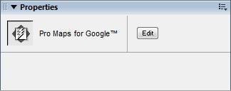
2 Using Pro Maps for Google This wizard adds a Pro Map for Google to your web page, allowing you to configure and specify several different configuration options. Upon specifying your Google Maps API key, you can configure multiple address locations for display in a given area from a dynamic data source or statically. For each address specified, you can customize the style and color of your address markers and information windows. As well, you can customize the map overlays, and include driving directions. and customize the size, zoom, inset, and scale attributes for the map generated. Maps cannot be previewed within Design View, so a placeholder image is used to assist you in sizing and placing the map within your page. A property inspector is available to access the wizard when the map is selected on the page, allowing you to make any changes when necessary. The code footprint for a Google Map will consist of several JavaScript files referenced in the head of the document and a div tag in the body of the page. Multiple maps can be inserted on a webpage with each having their own external JavaScript file. Access Insert menu > Google > Pro Maps Insert bar > Google > Insert Pro Maps Configuration The following steps details the configuration options necessary to complete the wizard and insert a Google Map within your web page. Use the Back and Next buttons to navigate between each of the steps of the wizard, and click Finish in Step 5 when you have completed configuration: Step 1: Enter Google API Key Step 2: Enter addresses or coordinates to map Step 3: Select the address marker, color, and info window for each address Step 4: Specify map options Step 5: Driving directions Editing an existing Pro Map for Google To edit the configuration options for an existing Pro Map for Google on a web page, select the map in Design View. The property inspector for the wizard becomes available, and you can click the Edit button to re-access the wizard and make any necessary changes.
3


4 Step 1: Enter Google API key The first step of the wizard specifies the Google Maps API key required to display maps using Google's service. API Key: a value generated by Google to ensure that you are using their map within a single website and to ensure they can track appropriate use of their mapping technology. This key is generated by entering the location of the site where this map will be staged. The map will only display if the key matches with the location the map request is made from. The above value can be generated in the following location: Testing: If you use a staging server with a different location than your live server, you will have issues for testing. To get around this issue, generate a key that can be used during your testing process specific to the location of your staging server. It will still work even if this is a local server (e.g. For your convenience, the following API key works for all testing servers that use the location for staging: ABQIAAAAvZMU4-DFRYtw1UlTj_zc6hT2yXp_ZAY8_ufC3CFXhHIE1NvwkxQcT1h- VA8wQL5JBdsM5JWeJpukvw
.")

5 Step 2: Enter addresses or coordinates to map In this step, all locations to be mapped are entered and listed in the display pane. You have the option of specifying a location either by address or by coordinates (latitude and longitude). In addition, location information can be specified statically as individual listings in the display pane, or by specifying dynamic data. Return multiple addresses for a single listing in the display pane using data bindings, including direct support for recordsets available on the page. When an address is selected from the display pane, its information populates the configuration fields, allowing you to modify it as necessary. Location panel Lists all locations included in your map. Shows the configured address or geo-location, the regional data for a given address, which address is the default to display the address in the map, and whether a listing is looping through a recordset to return address records for display. When a specific listing is selected, the controls below the pane update the configuration data associated to the listing. Add (+) button: Creates a new location entry in the display pane to configure for your map. Remove (-) button: Removes a location entry selected within the display pane. Default destination: Determines the address the map will be centered on and has the info window displayed for upon first viewing the map. If no address is marked as the default, the map will not have an info window opened on load of the page and the map will be centered on the last entered address. If a recordset listing is selected as the default, the first address record returned will be treated as the default address. Show multiple: Enables using an available recordset on the page to return location information for the given listing.


6 Use the data bindings for each location element to map database columns from the recordset selected. Type Select whether to use an address or coordinates to specify a location to be mapped. Specify the details for either criteria in a given listing. Address In address mode, the street, city, state, zip, and country fields are available to either specify address information directly, or use data bindings to map this information dynamically. This information needs to be as detailed as possible in order to ensure that a map is generated correctly. You may need to test to determine that your specified addresses get mapped correctly, either through the extension, or by visiting Google Maps online to enter and test a given address. Static Dynamic Coordinates In coordinates mode, specify a location using latitude and longitude. This allows you to specify exact locations if for some reason the Google geocoder is not returning accurate results or a specified country is not currently supported by the Google geocoder. Only numerical values can be accepted, with negative values corresponding to the Southern latitudes and Eastern longitudes.

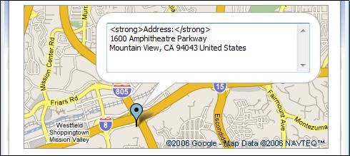
7 Step 3: Select the address marker, color, and info window for each address For each listing in the address pane, this step configures the type and color of address markers used for your configured addresses, as well the formatting for the address displayed that is associated to the given marker. When a listing corresponds to a recordset that contains multiple addresses, the applied formatting is the same for all addresses returned for that entry. Address marker: Selects the type of graphic used for the address entry currently selected. the selected marker is displayed in the preview pane to assist in selection. Color scheme: Selects the colors used in the address marker selected Info window: Displays the address when a location is selected in a displayed map. Default displays the address information according to Google's standard formatting. The custom feature allows you to specify html and text specific to your content and design requirements through the Preview pane. Preview Displays the marker and address configurations specified using the above controls to allow you to preview what your map will look like. When custom configurations of the info window is enabled, formatting and content can be specified directly within the textfield enabled in the pane.
8
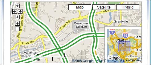
9 Step 4: Specify map options This step configures the size of the map on your page, as well as the optional controls that can be included in your map to assist the end user. The preview pane at the bottom updates with an example of each control option when enabled in this step to assist you in configuration. Dimensions Specifies the size of the map as it appears on your page. Width: The width of the map in pixels as it is displayed on the page. Height: The height of the map in pixels as it is displayed on the page. Controls Controls are optional elements that can be overlaid on the map to assist people in using it. When a control is selected or checked, the preview image updates accordingly to display an example of the given control option. Pan/Zoom: Offers options for the availability and extent of the tools provided in the map that allow you to move in any display direction relative to the original location, or zoom in and out. Scale: Enables or disables the display of the map scale to assist users in determining distance. Map Type: Enables or disables the display of additional map display options, including Satellite and a Hybrid, which is a combination of Satellite and Street mapping. Inset: Enables or disables the display of a high altitude display of the map in the lower right corner to provide a higher level context of the location detailed in the map to the viewer. Traffic: Displays Google s real-time, color-coded traffic display overlaid on the map. Preview Configuration options selected for the available controls update the preview pane to show an example of what a given feature looks like when enabled for your map.
10
Getting Started with Pro Maps for Google
 Getting Started with Pro Maps for Google This Getting Started Guide shows you how to get up and running with Pro Maps for Google. This Dreamweaver extension allows you to add static and dynamic maps to
Table of contents. DMXzone Google Maps Manual DMXzone.com
 Table of contents Table of contents... 1 About DMXzone Google Maps... 2 Features in Detail... 3 The Basics: Insterting DMXzone Google Maps on a Page... 16 Advanced: Creating Dynamic DMXzone Google Maps...
Table of contents. DMXzone Google Maps 2 DMXzone
 Table of contents Table of contents... 1 About... 2 Features in Detail... 3 The Basics: Inserting Google Maps on a Page... 20 Advanced: Control Google Maps with Behaviors... 27 Advanced: Track Your Current
STORE LOCATOR USER GUIDE Extension version: 1.0 Magento Compatibility: CE 2.0
 support@magestore.com sales@magestore.com Phone: +1-606-657-0768 STORE LOCATOR USER GUIDE Extension version: 1.0 Magento Compatibility: CE 2.0 Table of Contents 1. INTRODUCTION 3 Outstanding Features...3
Google Map for Magento 2
 Last update: 2018/03/16 11:06 magento_2:google_map https://amasty.com/docs/doku.php?id=magento_2:google_map For more details see the Google Map extension page. Google Map for Magento 2 Provide customers
Caspio Map Mashup v7 Developer Reference
 1. DataPage Setup Caspio Map Mashup v7 Developer Reference Configure your DataPage and map settings using the DataPage Wizard in Caspio Bridge. 1.1. Enable Parameters On the first screen of the DataPage
We do More VMAP DOCUMENTATION
 We do More VMAP DOCUMENTATION Overview VMap Component is a uniquely designed Joomla Extension that allows you to put your listings on Google Map. It provides you a very simple and flexible way to put anything
Store Locator for Magento 2. User Guide
 Store Locator for Magento 2 User Guide Table of Contents 1. Store Locator Configuration 1.1. Accessing the Extension Main Setting 1.2. General 1.3. Service API and Comments 1.4. Store Search 2. Store Locator
Final Project: Integrating ArcGIS Server with Google Maps Creating a Southern California Wildfire Mapping Application
 Final Project: Integrating ArcGIS Server with Google Maps Creating a Southern California Wildfire Mapping Application In the final project for this course you will be creating an integrated Google Maps
Find nearest dealer. Users guide
 Find nearest dealer Users guide January 2017 Digital Media, Group Marketing 1 Table of contents 1. Access to backend... 3 2 Front page... 4 2.1 Left navigation... 5 3 Stockists... 6 3.1 Overview... 6 3.2
Terratype Umbraco Multi map provider
 Terratype Umbraco Multi map provider Installation Installing via Nuget This Umbraco package can be installed via Nuget The first part is the Terratype framework, which coordinates the different map providers,
Zip Code Locator Software Hosted Solution
 Zip Code Locator Software Hosted Solution USER S GUIDE / Documentation www.geosprawl.com Document Version Control Version Date Change Description 1.0 12/17/2008 Created 2008Reachoutside, LLC. Do not copy
Corporation. GeoCode LOS
 Micropath Corporation 2023 Montane Drive East Tel: 303.526-5454 Web: www.micropath.com Golden, Colorado 80401-8099 Fax: 303.526-0202 E-Mail: sales@micropath.com GeoCode LOS GeoCode LOS generates radio
No Programming Required Create web apps rapidly with Web AppBuilder for ArcGIS
 No Programming Required Create web apps rapidly with Web AppBuilder for ArcGIS By Derek Law, Esri Product Manager, ArcGIS for Server Do you want to build web mapping applications you can run on desktop,
Terratype Umbraco Multi map provider
 Terratype Umbraco Multi map provider Installation Installing via Nuget This Umbraco package can be installed via Nuget The first part is the Terratype framework, which coordinates the different map providers,
Open Source Cloud Map User Guide
 Open Source Cloud Map User Guide Table of Contents Map Page... 1 Static Mercator Map... 1 Customizable Map... 1 Title Bar... 2 Toolbar... 2 Non Toolbar Navigation... 3 Map Window... 3 Layers / Legend Window...
STORE LOCATOR PLUGIN USER GUIDE
 support@simicart.com Support: +84.3127.1357 STORE LOCATOR PLUGIN USER GUIDE Table of Contents 1. INTRODUCTION... 3 2. HOW TO INSTALL... 4 3. HOW TO CONFIGURE... 5 4. HOW TO USE ON APP... 13 SimiCart Store
Google Map & Radius Search Realtyna Inc.
 1 Google Map & Radius Search Realtyna Inc. Contents of this manual are applicable to the RPL Google Map& Radius Search Add-on version 3.4+. If you have an older version of the membership add-on, sections
COMMISSION OF TEXAS MAY
 GIS Viewer RAILROAD COMMISSION OF TEXAS MAY 2017 Table of Contents GIS Viewer Basics... 1 Basics... 1 Screen Overview... 2 Tools... 5 Visibility... 5 Measure Tool... 7 Identify Tool... 10 Coordinates Tool...
Presented by: Megan Bishop & Courtney Valentine
 Presented by: Megan Bishop & Courtney Valentine Early navigators relied on landmarks, major constellations, and the sun s position in the sky to determine latitude and longitude Now we have location- based
Quick Google Maps. This document is published under the Open Content License available from
 Quick Google Maps - cbgooglemaps Quick Google Maps Quick Google Maps Extension Key: cbgooglemaps Language: en Keywords: foradmins, forbeginners Copyright 2000-2016, Christian Brinkert,
Google Earth. Tutorials. Tutorial 2: Annotating Google Earth
 Google Earth Tutorials Tutorial 2: Annotating Google Earth Google Earth makes it easy to create a map with annotations - you can add placemarks (points), paths (lines), polygons in Google Earth, and add
Django Map Widgets Documentation
 Django Map Widgets Documentation Release 0.1.9 Erdem Ozkol Oct 26, 2017 Contents 1 Achievements 3 1.1 Index................................................... 3 2 Indices and tables 13 i ii Configurable,
USER MANUAL. Quick Maps TABLE OF CONTENTS. Version: 2.1
 USER MANUAL Quick Maps Version: 2.1 Compatibility: Microsoft Dynamics CRM 2016(v8.0) and above TABLE OF CONTENTS Introduction... 2 Benefits of Quick Maps... 2 Prerequisites... 2 Installation & Configuration...
Adding text and shapefiles and editing their layer properties into ArcGIS.com
 Adding text and shapefiles and editing their layer properties into ArcGIS.com With the latest release of ArcGIS.com, you can add a layer to your map that was stored in a delimited text file (.txt or.csv),
The Photo Gallery. Adding a Photo Gallery Page. Adding a Photo Gallery App
 Adding a Photo Gallery Page The Photo Gallery Above the Summary tab, in the list of Current Pages, click on the New Page button. Choose Photo Gallery from the Available Page Types. Give the page a name.
ITSE 1401 Web Design Tools Lab Project 4 (Expression Web 4 - Units M, N, O, P) Last revised: 1/9/14
 Last revised: 1/9/14") (Expression Web 4 - Units M, N, O, P) Last revised: 1/9/14 Directions: Perform the tasks below on your personal computer or a lab computer. Professor Smith shows the score points for each activity in parentheses.
(Expression Web 4 - Units M, N, O, P) Last revised: 1/9/14 Directions: Perform the tasks below on your personal computer or a lab computer. Professor Smith shows the score points for each activity in parentheses.
iii Map Intelligence Client User Manual
 Map Intelligence Client User Manual iii Map Intelligence Client User Manual ii CONTENTS INTRODUCTION... 5 Purpose... 5 Audience... 5 Conventions... 6 Prerequisites... 6 CONCEPTS... 7 What is Map Intelligence?...
Address Management User Guide. PowerSchool 8.x Student Information System
 PowerSchool 8.x Student Information System Released July 2014 Document Owner: Documentation Services This edition applies to Release 8.0.1 of the PowerSchool software and to all subsequent releases and
Blue Form Builder extension for Magento 2
 Blue Form Builder extension for Magento 2 User Guide Version 1.0 Table of Contents I) Introduction......5 II) General Configurations....6 1) General Settings.....7 2) ReCaptcha... 8 III) Manage Forms......
Google Earth II: Create a tour with Google Earth
 Google Earth II: Create a tour with Google Earth This workshop is a continuation of The Google Earth Workshop I: Map-making Basics. You will create a tour to show the main and satellite campuses of the
Data Visualization Techniques with Google Earth
 Data Visualization Techniques with Google Earth E-Learning for the GIS Professional Any Time, Any Place! geospatialtraining.com Course Outline Module 1: Google Earth Pro Fundamentals Module 2: Adding Features
Preferential Resource Delivery Via Web Proxy or Web Browser
 Technical Disclosure Commons Defensive Publications Series December 11, 2017 Preferential Resource Delivery Via Web Proxy or Web Browser Dean Kenneth Jackson Daniel Klein Follow this and additional works
Overview. Setting Up. Geospatial Centre University of Waterloo May 2014
 Overview ArcGIS Online is a web-based mapping and app-building site created by Esri, the world leader in GIS software. In an effort to empower users of all levels to create interactive maps and applications
In this exercise you will display the Geo-tagged Wikipedia Articles Fusion Table in Google Maps.
 Introduction to the Google Maps API v3 Adding a Fusion Table to Google Maps Fusion Tables, still in the experimental stages of development, is a Google product that allows you to upload and share data
Xrm.Location AddOn User Manual
 Microsoft Dynamics CRM 2013/2015/2016 Xrm.Location AddOn User Manual Table of Contents Overview... 3 Configuring Xrm.Location... 4 GeoLocating Dynamics Crm Entities... 7 Placing GeoCoded Entities on a
Store Locator Magento 2 USER MANUAL E: P: +1-(248)
") Store Locator Magento 2 USER MANUAL MAGEDELIGHT.COM SUPPORT E: INFO@MAGEDELIGHT.COM SUPPORT@MAGEDELIGHT.COM P: +1-(248)-275-1202 P: License Key After successfully installing the Store Locator extension
Store Locator Magento 2 USER MANUAL MAGEDELIGHT.COM SUPPORT E: INFO@MAGEDELIGHT.COM SUPPORT@MAGEDELIGHT.COM P: +1-(248)-275-1202 P: License Key After successfully installing the Store Locator extension
iii Map Intelligence Client User Manual
 Map Intelligence Client User Manual iii TM Map Intelligence Client User Manual ii CONTENTS INTRODUCTION... 5 Purpose... 5 Audience... 5 Conventions... 6 Prerequisites... 6 CONCEPTS... 7 What is Map Intelligence?...
Introduction. Step 1. Build a Rifle Step 2. Choose a Mode Step 3. Establish Position Step 4. Obtain Atmospherics Step 5. Designate a Target
 User Manual 1.1.1 Introduction BallisticsARC currently has 2 modes, and each mode produces solutions independently. However, data entered through the main menu will apply to both modes. The only order
MicroStrategy Academic Program
 MicroStrategy Academic Program Creating a center of excellence for enterprise analytics and mobility. GEOSPATIAL ANALYTICS: HOW TO VISUALIZE GEOSPATIAL DATA ON MAPS AND CUSTOM SHAPE FILES APPROXIMATE TIME
Address Management User Guide. PowerSchool 6.0 Student Information System
 User Guide PowerSchool 6.0 Student Information System Released June 2009 Document Owner: Document Services This edition applies to Release 6.0 of the PowerSchool Premier software and to all subsequent
Django Map Widgets Documentation
 Django Map Widgets Documentation Release 0.1.8 Erdem Ozkol Mar 06, 2017 Contents 1 Achievements 3 1.1 Index................................................... 3 2 Indices and tables 11 i ii Configurable,
Geographical mapping of data
 BioNumerics Tutorial: Geographical mapping of data 1 Aim In many research projects, especially epidemiological, biological data is closely linked to geographical data. Geographical information provided
MapInfo Stratus. Version 41. MapInfo Stratus Administration Guide
 MapInfo Stratus Version 41 MapInfo Stratus Administration Guide Contents Chapter 1: Getting Started...7 Signing In and Out...8 Home...8 Version Number and Build Number...9 Using MapInfo Stratus Administration
Overview of SAS/GIS Software
 3 CHAPTER 1 Overview of SAS/GIS Software Introduction to Geographic Information Systems 3 Features of SAS Software 4 Data in SAS/GIS Applications 5 Spatial Data 5 Spatial Data Layers 6 Spatial Data Coverages
Vision-e 19 Gloria Lane Fairfield, NJ
 Version.0 Section Page 1.0 Manage User Licenses 3 1.1 Geocoding Your Records 4 1.2 Enabling Custom Objects 5 1.3 Create a Map 5 1.4 Import Report 6 1.5 Edit a Map 6 1.6 Clone a Map 7 1.7 Delete a Map 7
Juniata County, Pennsylvania
 GIS Parcel Viewer Web Mapping Application Functional Documentation June 21, 2017 Juniata County, Pennsylvania Presented by www.worldviewsolutions.com (804) 767-1870 (phone) (804) 545-0792 (fax) 115 South
Chapter 8: Using Toolbars
 Chapter 8: Using Toolbars As a GIS web application developer you want to focus on building functionality specific to the application you are constructing. Spending valuable time and effort adding basic
RAPIDMAP Geocortex HTML5 Viewer Manual
 RAPIDMAP Geocortex HTML5 Viewer Manual This site was developed using the evolving HTML5 web standard and should work in most modern browsers including IE, Safari, Chrome and Firefox. Even though it was
Tips on Excel. Discover some tips to organize and lay out your Excel file and convert it into a CSV or PDF file.
 Tips on Excel Your business partners or retailers are listed in an Excel file and you want to put them on an interactive map? It's simple with the Click2map's Editor. A simple import process exists to
Lab 1: Getting Started with IBM Worklight Lab Exercise
 Lab 1: Getting Started with IBM Worklight Lab Exercise Table of Contents 1. Getting Started with IBM Worklight... 3 1.1 Start Worklight Studio... 5 1.1.1 Start Worklight Studio... 6 1.2 Create new MyMemories
v9 Quick Start Guide
 v9 Quick Start Guide overview Driving Screen Most of your time using CoPIlot Truck will be spent on this screen. Let s take a moment and get familiar with the items you can interact with. Zoom Out Zoom
Introduction. Admin's Manual. Recommended web browsers. VehicleTracker. Welcome to VehicleTracker - the system for tracking your GPS Devices.
 Introduction VehicleTracker Admin's Manual Welcome to VehicleTracker - the system for tracking your GPS Devices. As an Administrator you can manage Operators, Event Rules and more. This manual covers both
Database Systems Lab. 19. Google Maps API 충남대학교컴퓨터공학과 데이타베이스시스템연구실
 데이타베이스시스템연구실 Database Systems Lab. 19. Google Maps API 충남대학교컴퓨터공학과 데이타베이스시스템연구실 Google Maps API Tutorial What is Google Maps? Allows you to display maps on your web site Google Maps API Google Maps API
OrgPublisher Photos, Logos, and Legends
 OrgPublisher Photos, Logos, and Legends Table of Contents Table of Contents Photos... 3 Inserting Photos... 3 Photo Wait Time... 5 Logos... 7 Adding a Logo... 7 Adding a Background Image... 8 Legends...
Table of contents. Ajax AutoComplete Manual DMXzone.com
 Table of contents Table of contents... 1 About Ajax AutoComplete... 2 Features in Detail... 3 The Basics: Creating a Basic AJAX AutoComplete Field... 12 Advanced: Generating an AutoComplete Field using
4H4Me Announcement Letter
 An announcement letter introducing 4H4Me can be created using 4HPlus! SQL mail merge files and Word s mail merge. This letter includes user IDs and passwords needed for members and leaders to log on to
Quick Start Guide. Intermap Technologies 8310 South Valley Highway, Suite 400 Englewood, CO USA
 ADPRO Quick Start Guide Intermap Technologies 8310 South Valley Highway, Suite 400 Englewood, CO 80112 USA No part of this document may be reproduced, stored in a retrieval system, or transmitted in any
SiteAssist Professional Help Documentation. Copyright 2008 WebAssist.com Corporation All rights reserved.
 SiteAssist Professional Help Documentation Copyright 2008 WebAssist.com Corporation All rights reserved. User Interface Access WebAssist Category of Insert toolbar SiteAssist Professional Wizard SiteAssist
Using Google Earth. Middlebury College Library and Information Services
 Using Google Earth Middlebury College Introduction: While Google Earth can be a fun tool for simply looking at the surface of the earth, there are many other more sophisticated features to explore. Google
Data to App: Web,Tablet and Smart Phone Duane Griffith, Montana State University,
 Data to App: Web,Tablet and Smart Phone Duane Griffith, Montana State University, griffith@montana.edu This tutorial is broken into several steps related mostly to the technology applied at each step.
Yandex.Maps API Background theory
 8.02.2018 .. Version 1.0 Document build date: 8.02.2018. This volume is a part of Yandex technical documentation. Yandex helpdesk site: http://help.yandex.ru 2008 2018 Yandex LLC. All rights reserved.
Sergio Luján Mora Department of Software and Computing Systems
 Sergio Luján Mora Department of Software and Computing Systems Embedding Google Maps in web pages GOOGLE MAPS Google Maps Documentation Simple Map Markers Info Window Index Google Maps GM is a geospatial
FleetLocate v2.7 User Guide
 FleetLocate v2.7 User Guide User Guide v2.7 - FleetLocate: Fleet & Asset Intelligence Contents FleetLocate Fleet Intelligence v2.7 User Guide... 5 Map Tab... 6 Changing and Printing the Map View... 6 Bookmarks
iii Map Intelligence Client User Manual
 Map Intelligence Client User Manual iii TM Map Intelligence Client User Manual ii CONTENTS INTRODUCTION... 5 Purpose... 5 Audience... 5 Conventions... 6 Prerequisites... 6 CONCEPTS... 7 What is Map Intelligence?...
STORE LOCATOR For Magento 2
 1 STORE LOCATOR For Magento 2 PREFACE Store locator also known as store finder empowers user to add unlimited stores with functionality of adding tags to differentiate them. It allows user to locate nearby
Mapper version 1.0 User's Manual
 Mapper version 1.0 User's Manual Contents 1 Introduction... 3 2 User Interface... 4 2.1 Main screen...4 2.1.1 Toolbar... 6 2.1.2 Image properties panel... 7 2.2 Project window... 10 2.3 Map window... 13
D4.5 Public Information System. FORCIP+: Forest Roads for Civil Protection
 D4.5 Public Information System FORCIP+: Forest Roads for Civil Protection Project title Call identifier Project acronym Forest Roads for Civil Protection (FORCIP+) Call for proposals 2015 for prevention
Week 8 Google Maps. This week you ll learn how to embed a Google Map into a web page and add custom markers with custom labels.
 Introduction Hopefully by now you ll have seen the possibilities that jquery provides for rich content on web sites in the form of interaction and media playback. This week we ll be extending this into
Activity 1.1.1: Using Google Earth to View the World
 Learning Objectives Upon completion of this activity, you will be able to: Explain the purpose of Google Earth. Explain the different versions of Google Earth. Explain the hardware and software requirements
Full Search Map Tab. This map is the result of selecting the Map tab within Full Search.
 Full Search Map Tab This map is the result of selecting the Map tab within Full Search. This map can be used when defining your parameters starting from a Full Search. Once you have entered your desired
Mobile Application Development Google Maps Android API
 Mobile Application Development Google Maps Android API Waterford Institute of Technology October 17, 2016 John Fitzgerald Waterford Institute of Technology, Mobile Application Development Google Maps Android
Working with Google Earth
 Working with Google Earth The Places panel in Google Earth serves as a repository to bookmark locations that you want easy access to. There are two folders located in Places: My Places and Temporary Places.
Chainage Alignment Tool USER MANUAL
 USER MANUAL April 2017 Disclaimer: There will be differences between this manual and the version of the IRAS software being used because of application configuration that is specific to your environment.
Possibility to hide or show a group devices
 Dispatching - Map The menu Map allows you to have a full overview, in real-time, on (all/a part of) your fleet. By scrolling the mouse, using the arrow keys or selecting a part of the map (by moving the
Mashup your Application
 Mashup your Application Presented by: Jane Raymond Presentation Outline Overview Flash Charting Alternatives HTML Editor Control Google Maps & Directions Mashup Overview A web page or application that
Making a Sackville Coastal Flood Map
 Making a Sackville Coastal Flood Map Demo covers: Accessing and previewing map templates Modifying map elements such as titles, data frames, legends & scale bars Drawing a graphic on a map Adding text
MOBILE COMPUTING 2/11/18. Location-based Services: Definition. Convergence of Technologies LBS. CSE 40814/60814 Spring 2018
 MOBILE COMPUTING CSE 40814/60814 Spring 2018 Location-based Services: Definition LBS: A certain service that is offered to the users based on their locations. Convergence of Technologies GIS/ Spatial Database
Acrobat X Professional
 Acrobat X Professional Toolbar Well Page Navigations/Page Indicator Buttons for paging through document Scroll Bar/box page indicator appears when using the scroll button to navigate. When you release
Chapter 1 Introduction to Dreamweaver CS3 1. About Dreamweaver CS3 Interface...4. Creating New Webpages...10
 CONTENTS Chapter 1 Introduction to Dreamweaver CS3 1 About Dreamweaver CS3 Interface...4 Title Bar... 4 Menu Bar... 4 Insert Bar... 5 Document Toolbar... 5 Coding Toolbar... 6 Document Window... 7 Properties
Acceptance Test Plan. for WAVED. Version 3.0. Prepared By: Sean Bluestein, Kristian Calhoun, Keith Horrocks, Steven Nguyen, Hannah Pinkos
 Acceptance Test Plan for WAVED Version 3.0 Prepared By: Sean Bluestein, Kristian Calhoun, Keith Horrocks, Steven Nguyen, Hannah Pinkos Advisor: Kurt Schmidt Stakeholder: Climate Central 2 Table of Contents
Note: This tutorial was designed for Windows users. Applications DANA PORTER LIBRARY. February 19, 2013 Authored by: The Geospatial Centre
 Applications DANA PORTER LIBRARY February 19, 2013 Authored by: The Geospatial Centre 0 TABLE OF CONTENTS Google Earth Introduction... 2 Historical Imagery... 3 Objective... 3 Step by Step... 3 Ruler...
Microsoft Office 2016 Mail Merge
 Microsoft Office 2016 Mail Merge Mail Merge Components In order to understand how mail merge works you need to examine the elements involved in the process. In any mail merge, you'll deal with three different
Word 2010 Mail Merge. by Usman on March 05, 2010
 Word 2010 Mail Merge by Usman on March 05, 2010 Word 2010 includes Mail Merge feature, which enables user to create documents (Letter, Emails, Fax etc) that are essentially the same but contains unique
Dreamweaver MX The Basics
 Chapter 1 Dreamweaver MX 2004 - The Basics COPYRIGHTED MATERIAL Welcome to Dreamweaver MX 2004! Dreamweaver is a powerful Web page creation program created by Macromedia. It s included in the Macromedia
DataAssist Help Documentation
 DataAssist Help Documentation Copyright 2005-2007 WebAssist.com Corporation All rights reserved. Contents System Requirements DataAssist Wizard DataAssist Search Wizard DataAssist Search server behavior
USER MANUAL. Quick Maps TABLE OF CONTENTS. Version: 1.0
 USER MANUAL Quick Maps Version: 1.0 Compatibility: Microsoft Dynamics CRM 2016(v8.0) and above TABLE OF CONTENTS Introduction... 2 Benefits of Quick Maps... 2 Prerequisites... 2 Installation & Configuration...
Viewer Features. DataBC Mashup Framework (DMF)
") Viewer Features DataBC Mashup Framework (DMF) Copyright 2014 Ministry of Labour, Citizens' Services and Open Government All Rights Reserved. Printed in Canada The information contained in this document
Viewer Features DataBC Mashup Framework (DMF) Copyright 2014 Ministry of Labour, Citizens' Services and Open Government All Rights Reserved. Printed in Canada The information contained in this document
Terratype Umbraco Multi map provider
 Terratype Umbraco Multi map provider Installation Installing via Nuget This Umbraco package can be installed via Nuget The first part is the Terratype framework, which coordinates the different map providers,
MS2. Modern Traffic Analytics ms2soft.com
 MS2 Modern Traffic Analytics ms2soft.com Updated: October 31, 2014 Table of Contents 1 Introduction 3 2 Search Types 6 3.1 Search by: Study Location 11 3.2 Search by: Crash Data 12 3.3 Search Results Page
Geocortex Workflow Tutorial Create the Search Schools Workflow
 Geocortex Workflow Tutorial Create the Search Schools Workflow July-2011 www.geocortex.com/essentials Latitude Geographics Group Ltd. 200-1117 Wharf St, Victoria, BC V8W 1T7 Canada Tel: (250) 381-8130
Extending ArcGIS Maps for SharePoint. Quan Tang Scott Ball
 Extending ArcGIS Maps for SharePoint Quan Tang Scott Ball Agenda Extending ArcGIS Maps for SharePoint ArcGIS platform overview ArcGIS + SharePoint = Better together ArcGIS Maps for SharePoint overview
Introduction to Programming the Google Maps API
 Introduction to Programming the Google Maps API E-Learning for the GIS Professional Any Time, Any Place! geospatialtraining.com Course Modules Module 1: Introduction to Programming the Google Maps API
Guide to Mapping Website (Public) December 2016 GC_236594
 December 2016 GC_236594") Guide to Mapping Website (Public) December 2016 GC_236594 Table of Contents Guide to Mapping Website (Public)... 1 December 2016... 1 Quick Start... 3 Map Layers... 4 How do I?... 5 Draw on the Map...
Guide to Mapping Website (Public) December 2016 GC_236594 Table of Contents Guide to Mapping Website (Public)... 1 December 2016... 1 Quick Start... 3 Map Layers... 4 How do I?... 5 Draw on the Map...
Climate-Smart New Orleans
 Climate-Smart New Orleans Table of Contents GETTING THERE... 2 Accessing the site... 2 Logging into the site... 2 Navigating the Map... 2 Zoom & Pan... 2 Change the map background... 3 Interacting in the
Store Locator. Extension Configuration. For more details see the Store Locator extension page.
 For more details see the Store Locator extension page. Store Locator Help customers to find the nearest offline store location to purchase your products. Display all stores on the handy map using Google
Google Maps maps.google.com
 Google Maps maps.google.com Search and print directions example hotels near Meijer Gardens Type meijer gardens grand rapids mi and click search button The box to the left gives helpful information such
About Freeway. Freeway s Tools and Palettes
 About Freeway The most important thing to appreciate before you start a site in Freeway is how the process works, especially if you have tried other Web publishing software before. Freeway is not an HTML
Leaflet.js is an open-source library using which we can deploy interactive, simple, lightweight and simple web maps.
 About the Tutorial Leaflet.js is an open-source library using which we can deploy interactive, simple, lightweight and simple web maps. Audience This tutorial is meant for all those readers who would like
How To: Geocode. Quest Analytics Suite Geocoding. Geocoding in the Quest Analytics Suite 1. When the software is open, select the Tools dropdown.
 How To: Geocode in the Quest Analytics Suite 1. When the software is open, select the Tools dropdown. 2. Click the option for Geocode a Table 3. On the left-hand side of the pop up box there are 5 circles