Getting the most from the Maplex Label Engine
|
|
|
- Charity Wade
- 6 years ago
- Views:
Transcription


1 Esri International User Conference San Diego, California Technical Workshops July 26, 2012 Getting the most from the Maplex Label Engine Craig Williams Natalie Matthews
2 2 Presentation Overview What are the types of text in ArcGIS? - Labeling vs. Annotation - The role of the Maplex Label Engine Position properties Demo - street labeling Fitting strategies Label density control Conflict resolution properties Demo - Maximizing text placement Annotation Summary Questions
3 3 What Are The Types Of Text in ArcGIS? What are Labels? - Dynamically placed text by a label engine - Map refresh generates new text locations - Placed text can be locked after placement What is Annotation? - Stored - Geodatabase - Map document - Editable


4 4 Labels to Annotation Cycle Geodatabase annotation editing tools Convert to annotation ESRI Label Engines Maplex Label Engine Standard Label Engine Label maps Dynamic, tiled, or printed maps A
5 5 Labeling In ArcMap Unified user experience for both label engines - Labeling toolbar - Label Manager - Feature weights - Label priorities - Lock labels, view unplaced labels Integration of the Maplex Label Engine - Plugs in to standard tools - Uses ArcGIS text symbol - Uses standard label expression and label class organization
6 6 Maplex Label Engine Advanced high-quality cartographic text placement engine Fully integrated with ArcGIS - Shared tools - Full annotation support Numerous placement options End goal of reducing map production time and costs Licensing - ArcGIS , an extension (Maplex for ArcGIS) - At 10.1 all functionality is included with all license levels of ArcGIS


7 What s new in ArcGIS 10.1 Maplex label engine included at all license levels Python label expressions Global Maplex properties now at the label class level New label placement options and improvements Key numbering Straddle lines Borders and Junctions A


8 8 Labeling Toolbar Central location for labeling needs Extra commands enabled with Maplex Common tools for both label engines Quality placement for Maplex for ArcGIS Maplex Specific Commands

9 9 Label Manager Central location for label classes Easy access to common parameters

10 10 Label Summary Highlights potential problems in labeling properties

11 11 Label Weights Define weights to control behavior when labels and features overlap Maplex weighting is based on values from A value of 1000 is always treated as a barrier

12 12 Label Priority Order of label placement priority Label class level property Also serves as the deletion priority for conflict resolution


13 Line Label Position 13

14 Line Label Offset 14

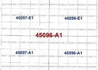
15 15 Street Placement Street placement mode End of street clearance Strategies optimized for placing street labels


16 16 Contour Placement Contour placement mode Page or Uphill alignment Label laddering

17 Street Labeling Street placement Overrun features Abbreviation dictionary Font reduction Strategy order

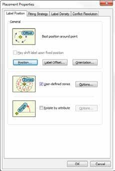
18 Point Label Positioning 18


19 Point Label Rotation 19

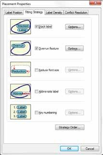
20 Polygon Label Positioning 20


21 Fixed Position Within A Polygon 21

22 Positioning Outside Of A Polygon 22

23 23 Polygon Border Labeling Opposing labels are placed together Option to repeat labels at a distance Single sided boundaries optionally labeled


24 24 Polygon Leader Anchor Points Multiple options for placement of leader line anchor point when labeling polygons


25 25 Label orientation Align to the graticule Available to any label placed horizontally East Asian vertical text placement Font must have vertical text metrics

26 Label Fitting Strategies 26

27 27 Strategy Order Select the order which fitting strategies are tried

28 28 Label Stacking Add new character Control the horizontal alignment Control the line break Dynamic stacking Automatic stacking Space, comma Automatic alignment Left, right, center Controlled stacking User-defined characters Forced stacking Control justification

29 29 Label Reduction Font size reduction Stepped decreases in font size to fit a label Font width reduction Stepped decreases in width of characters to fit a label

30 30 Label Abbreviations Imported and exported to/from files or database tables Multiple dictionaries per map Translation, Keyword, and Ending types Truncation option not tied to a dictionary See KB for US streets example

31 31 Key Numbering Labels that don t fit are replaced with a number Label text then placed in a list Key numbering groups can span multiple label classes

32 Label Density 32
")
33 33 Conflict Resolution Additional access to label weights Specify background labeling Last resort Never remove (place overlapping) option
34 34 Labeling Process Labeling occurs after features draw 1. Properties are gathered from layers 2. Properties are sorted by priority 3. Barriers are gathered from the map 4. Properties and barriers are then passed to the label engine 5. Result is placed text drawn to screen


35 Maximizing text placement Boundary labels Contour labels River labels Internal/External zones Street adresses Callouts Key Numbering

36 36 Converting Labels to Annotation Convert Labels to Annotation dialog - WYSIWYG conversion - Grid showing all target annotation feature classes - Unplaced labels written as annotation to the database - Unplaced Annotation Window Batch Tiled Labels to Annotation tool in ArcToolbox Contour Annotation tool in ArcToolbox
37 38 Annotation Feature Class Graphic text stored in the Geodatabase Each feature class has a symbol collection - Improves productivity - Promotes standardization - Created when converting from labels Control over feature-linked annotation behavior - Creation of new features - Modification of feature geometry
38 39 Managing Annotation Annotation Classes Feature class can have multiple annotation classes - Reduces the number of feature classes - Big performance gain in drawing and relationship logic - Created from label classes when converting to annotation Each annotation class has: - An expression - A symbol - A scale range

39 40 Managing Annotation Annotation properties are exposed as individual feature attributes - Supports queries against text symbol information - Allows for bulk updates to symbol properties

40 41 Editing Annotation - Overview Tightly integrated with feature editing environment Efficient experience when working with unplaced annotation Supports editing of multi-word annotation Leader line support Edit Annotation tool on the main Editor toolbar San Diego Enter text for next construction Feature templates for efficient feature creation
41 42 Constructing New Annotation WYSIWYG construction tools - Provide visual feedback - Place annotation where you want it the first time Productivity shortcuts - Hotkeys - Templates allow for predefined symbol / attribute choices - Use of expression to derive text (Cntrl-W)

42 43 Maplex help and resources Examples Detailed explanations of options Help now integrated with the rest of labeling help Common labeling tasks ArcGIS 10.1 Maplex Web Help See Esri templates for examples of Maplex in use
43 44 Summary Maplex is an advanced high-quality cartographic text placement engine Integrates with the existing labeling and annotation experience Provides numerous placement properties and strategies to define the location of labels Efficient tools to edit annotation New functionality at ArcGIS 10.1
44 Thank you for attending Have fun at UC2012 Open for Questions Please fill out the evaluation: First Offering ID: 604 Second Offering ID: 1948
Creating Great Labels Using Maplex
 Esri International User Conference San Diego, CA Technical Workshops July 11 15, 2011 Creating Great Labels Using Maplex Craig Williams Natalie Vines 2 Presentation Overview What are the types of text
Advanced Map Labeling using Maplex. Wendy Harrison & Samuel Troth
 Advanced Map Labeling using Maplex Wendy Harrison & Samuel Troth Presentation Overview We ll be using ArcGIS Pro Introduction - Different types of text in ArcGIS - role of the Maplex Label Engine labeling
Annotation/Labeling Workshop. Tim Rankin Pat Dolan
 Annotation/Labeling Workshop Tim Rankin Pat Dolan Agenda 8:00am - Introductions 8:05am - Goals of the Workshop 8:15am Labeling 8:45am Annotation Part I 9:15am Break 9:25am Annotation Part II 9:50am Questions
Labeling, Annotation, Editing, and Text Placement with ArcGIS. Ralph Denkenberger
 Labeling, Annotation, Editing, and Text Placement with ArcGIS Ralph Denkenberger Overview Define labels & annotation Work with labels Convert labels to annotation Work with annotation Questions 2 Map has
ArcGIS 9. Maplex Tutorial
 ArcGIS 9 Maplex Tutorial Copyright 004 006 ESRI All rights reserved. Printed in the United States of America. The information contained in this document is the exclusive property of ESRI. This work is
ArcMap Tips and Tricks
 2013 Esri International User Conference July 8 12, 2013 San Diego, California Technical Workshop ArcMap Tips and Tricks Jack Horton Jorge Ruiz-Valdepeña Esri UC2013. Technical Workshop. Jorge s Agenda
ArcGIS Basics Working with Labels and Annotation
 ArcGIS Basics Working with Labels and Annotation Labeling in ArcGIS has changed considerably from the old ArcView 3.X version. In ArcGIS label positions are generated automatically, are not selectable,
ArcMap: Tips and Tricks
 Esri International User Conference San Diego, California Technical Workshops July 23 27, 2012 ArcMap: Tips and Tricks Miriam Schmidts Jorge Ruiz-Valdepena Agenda Navigating ArcMap Repairing data links
Esri Production Mapping An Introduction
 Esri International User Conference San Diego, California Technical Workshops July 25, 2012 Esri Production Mapping An Introduction Lana Tylka Amber Bethell Workshop Overview Part I - Industry challenges
EnvSci360 Computer and Analytical Cartography
 EnvSci360 Computer and Analytical Cartography Lecture 5 Working with Type and Labels Key Points Labels are text that locate and identify features on a map Important for readability & communication EnvSci
Designing and Using Cached Map Services
 Esri International User Conference San Diego, California Technical Workshops July 2012 Designing and Using Cached Map Services Sterling Quinn Eric Rodenberg What we will cover Session Topics - Map cache
In this exercise, you will convert labels into geodatabase annotation so you can edit the text features.
 Instructions: Use the provided data stored in a USB. For the report: 1. Start a new word document. 2. Follow an exercise step as given below. 3. Describe what you did in that step in the word document
Designing and Using Basemaps. Jennifer Hughey
 Designing and Using Basemaps Jennifer Hughey Agenda The ArcGIS System Basemaps are a key component of your system Cartographic design considerations Using basemap layers in ArcMap Best practices for designing
Chapter 5. Presenting Data
 Chapter 5. Presenting Data Copyright McGraw-Hill Education. Permission required for reproduction or display. 5-1 Map Design Process 5-2 1 About ArcGIS Chapter 5. Presenting Data 5-3 Page layouts and map
Working with Metadata in ArcGIS
 Esri International User Conference San Diego, California Technical Workshops July 26, 2012 Working with Metadata in ArcGIS Aleta Vienneau Metadata in ArcGIS ArcGIS metadata goals Editing metadata Setting
Best Practices for Designing Effective Map Services
 2013 Esri International User Conference July 8 12, 2013 San Diego, California Technical Workshop Best Practices for Designing Effective Map Services Ty Fitzpatrick Tanu Hoque What s in this session Map
Search & Rescue Map Specifications and Production Workflows
 Search & Rescue Map Specifications and Production Workflows About The Search & Rescue map product and production procedures discussed in this document can be utilized to support search, rescue, and relief
Surface Analysis with 3D Analyst
 2013 Esri International User Conference July 8 12, 2013 San Diego, California Technical Workshop Surface Analysis with 3D Analyst Khalid H. Duri Esri UC2013. Technical Workshop. Why use 3D GIS? Because
ArcGIS. for Desktop. Tips and Shortcuts 10.1
 ArcGIS 10.1 for Desktop Tips and Shortcuts Map Navigation Refresh and redraw the display. F5 Suspend the map s drawing. F9 Zoom in and out. Center map. Roll the mouse wheel backward and forward. Hold down
Surface Creation & Analysis with 3D Analyst
 Esri International User Conference July 23 27 San Diego Convention Center Surface Creation & Analysis with 3D Analyst Khalid Duri Surface Basics Defining the surface Representation of any continuous measurement
Managing Imagery and Raster Data Using Mosaic Datasets
 2013 Esri International User Conference July 8 12, 2013 San Diego, California Technical Workshop Managing Imagery and Raster Data Using Mosaic Datasets Hong Xu, Prashant Mangtani Esri UC2013. Technical
Table of Contents. 1. Prepare Data for Input. CVEN 2012 Intro Geomatics Final Project Help Using ArcGIS
 Table of Contents 1. Prepare Data for Input... 1 2. ArcMap Preliminaries... 2 3. Adding the Point Data... 2 4. Set Map Units... 3 5. Styling Point Data: Symbology... 4 6. Styling Point Data: Labels...
ArcGIS. ArcGIS Desktop. Tips and Shortcuts
 ArcGIS ArcGIS Desktop Tips and Shortcuts Map Navigation Refresh and redraw the display. F5 9.1, Suspend the map s drawing. F9 9.1, Zoom in and out. Center map. Roll the mouse wheel backward and forward.
Building Applications with the ArcGIS Runtime SDK for WPF
 Esri International User Conference San Diego, California Technical Workshops 24 th July 2012 Building Applications with the ArcGIS Runtime SDK for WPF Euan Cameron & Paul Pilkington Agenda Introduction
Integrating CAD Data with ArcGIS
 Integrating CAD Data with ArcGIS Agenda An Overview of CAD Drawings CAD Data Structure in ArcGIS Visualization Georeferencing Data Conversion ArcGIS for AutoCAD Q & A CAD Drawings - Overview Widely used
7/14/2009. Chapters Autocad Multi Line Text Tools. Multi Line Text Tool Ribbon. Multi Line Text Tool. July 14, 2009
 Chapters 9-11 July 14, 2009 Chapter 9 Learning Objectives Describe and use proper text standards. Calculate drawing scale and text height. Develop and use text styles. Make multiple lines of text with
ArcPad An Introduction
 2013 Esri International User Conference July 8 12, 2013 San Diego, California Technical Workshop ArcPad An Introduction Chris LeSeuer, Marika Vertzonis, Hannah Ferrier Esri UC2013. Technical Workshop.
Cartographic Techniques and Representations
 Cartographic Techniques and Representations NEARC 2007 ESRI Technical Session ESRI, Boston Overview of Presentation Labeling and Annotation Masking Layout Tips Cartographic Representations Labeling versus
ArcMap Editing Tips and Tricks. Sean Jones
 ArcMap Editing Tips and Tricks Sean Jones Overview Topics - Tuning your editing map - Creating features - Editing features and attributes - Aligning and editing coincident features - Addins Format - Software
Lidar Working with LAS Datasets
 2013 Esri International User Conference July 8 12, 2013 San Diego, California Technical Workshop Lidar Working with LAS Datasets Raghav Vemula (3D Team) Esri UC2013. Technical Workshop. Agenda Las Dataset
Your Prioritized List. Priority 1 Faulted gridding and contouring. Priority 2 Geoprocessing. Priority 3 Raster format
 Your Prioritized List Priority 1 Faulted gridding and contouring Priority 2 Geoprocessing Priority 3 Raster format Priority 4 Raster Catalogs and SDE Priority 5 Expanded 3D Functionality Priority 1 Faulted
Schematics in ArcMap Tutorial
 Schematics in ArcMap Tutorial Copyright 1995-2010 Esri All rights reserved. Table of Contents Introducing Schematics in ArcMap Tutorial........................ 3 Exercise 1: Getting familiar with Schematics
What s New in Desktop 10.1
 What s New in Desktop 10.1 Damian Spangrud Esri Redlands Trip Down Memory Lane ArcGIS A Complete System for Geographic Information Cloud Web Online Mobile Enterprise Desktop Sharing Information sharing
Bringing your Data to Life in the ArcGIS API for JavaScript: Vector Tiles. Craig Williams &
 Bringing your Data to Life in the ArcGIS API for JavaScript: Vector Tiles Craig Williams & Rene Rubalcava @williamscraigm @odoenet Overview Why vector tiles? Vector tiles in ArcGIS ArcGIS vector tile basemaps
Editing & Maintaining Parcels with ArcMap. Christine Leslie Amy Andis
 Editing & Maintaining Parcels with ArcMap Christine Leslie Amy Andis What to expect An introduction to the parcel fabric A detailed explanation of the parcel fabric data model General editing techniques
Editing Versioned Geodatabases : An Introduction
 Esri International User Conference San Diego, California Technical Workshops July 24, 2012 Editing Versioned Geodatabases : An Introduction Cheryl Cleghorn Shawn Thorne Assumptions: Basic knowledge of
GIS IN ECOLOGY: CREATING RESEARCH MAPS
 GIS IN ECOLOGY: CREATING RESEARCH MAPS Contents Introduction... 2 Elements of Cartography... 2 Course Data Sources... 3 Tasks... 3 Establishing the Map Document... 3 Laying Out the Map... 5 Exporting Your
Working with Feature Layers. Russell Brennan Gary MacDougall
 Working with Feature Layers Russell Brennan Gary MacDougall Working with Feature Layers Session will focus on feature access and editing Highlight new features added over the last few releases Agenda Introduction
Python Map Automation Beyond the Basics of arcpy.mapping
 2013 Esri International User Conference July 8 12, 2013 San Diego, California Technical Workshop Python Map Automation Beyond the Basics of arcpy.mapping Jeff Barrette Jeff Moulds Esri UC2013. Technical
Desktop Mapping: Creating Vector Tiles. Craig Williams
 Desktop Mapping: Creating Vector Tiles Craig Williams Edie Punt @williamscraigm @epunt Overview Why vector tiles? Vector tiles in ArcGIS ArcGIS vector tile basemaps Consuming and styling vector tiles Overview
ArcGIS Pro: What s New in Editing and Data Management
 Federal GIS Conference February 9 10, 2015 Washington, DC ArcGIS Pro: What s New in Editing and Data Management Robert LeClair ArcGIS Pro Overview Esri FedUC 2015 Technical Workshop ArcGIS Pro: What's
Lecture 6 MAP DESIGN: PART II. Map Elements, Cartography, Text, Annotation, Labels and Graphics
 Lecture 6 MAP DESIGN: PART II Map Elements, Cartography, Text, Annotation, Labels and Graphics Outline What is a good map? Things to think about when making a map Design Process Map Elements Labels Annotation
Press the Plus + key to zoom in. Press the Minus - key to zoom out. Scroll the mouse wheel away from you to zoom in; towards you to zoom out.
 Navigate Around the Map Interactive maps provide many choices for displaying information, searching for more details, and moving around the map. Most navigation uses the mouse, but at times you may also
1. ArcGIS Desktop 10 (ArcView, ArcEditor, or. 2. Sample dataset from esri.com/arcuser. 3. ArcGIS Maplex extension (optional)
") Changing Lanes Converting DS Map Books to ArcGIS 10 Data Driven Pages By Mike Price, Entrada/San Juan, Inc. What You Will Need 1. ArcGIS Desktop 10 (ArcView, ArcEditor, or ArcInfo license) 2. Sample dataset
Changing Lanes Converting DS Map Books to ArcGIS 10 Data Driven Pages By Mike Price, Entrada/San Juan, Inc. What You Will Need 1. ArcGIS Desktop 10 (ArcView, ArcEditor, or ArcInfo license) 2. Sample dataset
ArcGIS for Server Performance and Scalability Optimizing GIS Services
 Esri International User Conference San Diego, California Technical Workshops July 26, 2012 ArcGIS for Server Performance and Scalability Optimizing GIS Services Andrea Rosso (Esri), Craig Williams (Esri),
Understanding ArcGIS Pipeline Referencing for Vertically Integrated Gas Companies. GeoConX 2017 September 7, 2017
 Understanding ArcGIS Pipeline Referencing for Vertically Integrated Gas Companies GeoConX 2017 September 7, 2017 The Asset Intelligence Imperative GOAL The necessity to learn ever more, in as close to
ArcGIS. Desktop. A Selection of Time-Saving Tips and Shortcuts
 ArcGIS Desktop A Selection of Time-Saving Tips and Shortcuts Map Navigation Refresh and redraw the display F5 9.1, Suspend the map s drawing F9 9.1, Zoom in and out Roll the mouse wheel backward and forward.
ArcGIS Pro Editing: An Introduction. Jennifer Cadkin & Phil Sanchez
 ArcGIS Pro Editing: An Introduction Jennifer Cadkin & Phil Sanchez See Us Here WORKSHOP ArcGIS Pro Editing: An Introduction LOCATION SDCC - Ballroom 20 D TIME FRAME Thursday 10:00 11:00 ArcGIS Pro: 3D
ArcGIS Online: Three-and-a-Half Ways to Create Tile Layers. Eric Anderson & Adam Eversole Esri Support Services
 ArcGIS Online: Three-and-a-Half Ways to Create Tile Layers Eric Anderson & Adam Eversole Esri Support Services Agenda 1. Introduction 2. What is a tile layer 3. How a tile layer works 4. The 3 ½ ways to
4. If you are prompted to enable hardware acceleration to improve performance, click
 Exercise 1a: Creating new points ArcGIS 10 Complexity: Beginner Data Requirement: ArcGIS Tutorial Data Setup About creating new points In this exercise, you will use an aerial photograph to create a new
Efficiently create and edit features in ArcMap
 Efficiently create and edit features in ArcMap Esri Malaysia Sdn Bhd Suite 10-01-02, Level 10, PJX-HM Shah Tower, 16A, Persiaran Barat, Petaling Jaya 46050 Selangor +60 (3) 7629 5518 info@esrimalaysia.com.my
Desktop Mapping: Creating Vector Tiles. Craig Williams &
 Desktop Mapping: Creating Vector Tiles Craig Williams & Edie Punt @williamscraigm @epunt Overview Why vector tiles? Vector tiles in ArcGIS ArcGIS vector tile basemaps Consuming and styling vector tiles
Explore some of the new functionality in ArcMap 10
 Explore some of the new functionality in ArcMap 10 Scenario In this exercise, imagine you are a GIS analyst working for Old Dominion University. Construction will begin shortly on renovation of the new
Geographical Information Systems Institute. Center for Geographic Analysis, Harvard University. LAB EXERCISE 1: Basic Mapping in ArcMap
 Harvard University Introduction to ArcMap Geographical Information Systems Institute Center for Geographic Analysis, Harvard University LAB EXERCISE 1: Basic Mapping in ArcMap Individual files (lab instructions,
ArcGIS Desktop: Making Maps in ArcMap
 ArcGIS Desktop: Making Maps in ArcMap California, Nevada, Hawaii Regional User Group February 6-8, 6 2008 Sacramento, CA Harry J. Moore IV Outline Symbology Style Files -.style Layer files -.lyr Labeling
Developers Road Map to ArcGIS Desktop and ArcGIS Engine
 Developers Road Map to ArcGIS Desktop and ArcGIS Engine Core ArcObjects Desktop Team ESRI Developer Summit 2008 1 Agenda Dev Summit ArcGIS Developer Opportunities Desktop 9.3 SDK Engine 9.3 SDK Explorer
ArcPad An Introduction
 ArcPad An Introduction Chris LeSueur, Marika Vertzonis, Hannah Ferrier ArcPad Sessions at the UC Demo Theatre - Preparing and Deploying Data to ArcPad - Using ArcPad in the Field - Customizing ArcPad without
ArcGIS. ArcGIS Desktop. Tips and Shortcuts
 ArcGIS ArcGIS Desktop Tips and Shortcuts Map Navigation Function Shortcut Availability Refresh and redraw the display. F5 9.1, Suspend the map s drawing. F9 9.1, Zoom in and out. Center map. Roll the mouse
Esri UC2013. Technical Workshop. Type Presentation Name Here
 Type Presentation Name Here 2013 Esri International User Conference July 8 12, 2013 San Diego, California Technical Workshop 3D Analyst An Introduction Deepinder Deol Michael Contreras Why use 3D GIS?
Network Analyst: An Introduction
 2013 Esri International User Conference July 8 12, 2013 San Diego, California Technical Workshop Network Analyst: An Introduction Patrick Stevens Robert Garrity Esri UC2013. Technical Workshop. Introduction
LAB 1: Introduction to ArcGIS 8
 LAB 1: Introduction to ArcGIS 8 Outline Introduction Purpose Lab Basics o About the Computers o About the software o Additional information Data ArcGIS Applications o Starting ArcGIS o o o Conclusion To
Impress Guide Chapter 11 Setting Up and Customizing Impress
 Impress Guide Chapter 11 Setting Up and Customizing Impress This PDF is designed to be read onscreen, two pages at a time. If you want to print a copy, your PDF viewer should have an option for printing
Reset Cursor Tool Clicking on the Reset Cursor tool will clear all map and tool selections and allow tooltips to be displayed.
 SMS Featured Icons: Mapping Toolbar This document includes a brief description of some of the most commonly used tools in the SMS Desktop Software map window toolbar as well as shows you the toolbar shortcuts
What s s Coming in ArcGIS 10 Desktop
 What s s Coming in ArcGIS 10 Desktop Damian Spangrud ArcGIS Product Manager, ESRI dspangrud@esri.com (or at least turn to silent) ArcGIS 10 A Simple & Pervasive System for Using Maps & Geographic Information
What should y you expect in this session? Basic to advanced topics Outline What is map caching? Why should I cache? Caching workflow How to create a c
 Designing, Deploying, and Using Cached Map Services David Crosby & Craig Mesimer What should y you expect in this session? Basic to advanced topics Outline What is map caching? Why should I cache? Caching
Arcgis 10 Manually Move Labels
 Arcgis 10 Manually Move Labels The "easy custom labeling" Tool in QGIS seems to come close to the ArcGIS solution. However, after I created my custom label layer I am not able to move my labels at the
Topology in the Geodatabase an Introduction. Erik Hoel Doug Morgenthaler
 Topology in the Geodatabase an Introduction Erik Hoel Doug Morgenthaler ESRI Super Secret Topology Laboratory, May 2012 Agenda ArcGIS Topology defined Validating a topology Editing a topology Geoprocessing
ArcGIS Desktop The Road Ahead. Amadea Azerki
 ArcGIS Desktop The Road Ahead Amadea Azerki Agenda An Overview of ArcGIS 10 Desktop Enhancements User Interface Mapping Editing Analysis Sharing Q & A ArcGIS 10 Overview Focuses on Usability and Productivity
Geography 281 Map Making with GIS Project Two: Map Design Issues in ArcMap
 Geography 281 Map Making with GIS Project Two: Map Design Issues in ArcMap This activity provides an introduction to the map design process. It takes you through a typical sequence from the initial decision
Tutorial 1: Downloading elevation data
 Tutorial 1: Downloading elevation data Objectives In this exercise you will learn how to acquire elevation data from the website OpenTopography.org, project the dataset into a UTM coordinate system, and
Caching Imagery Using ArcGIS
 2013 Esri International User Conference July 8 12, 2013 San Diego, California Technical Workshop Caching Imagery Using ArcGIS Hong Xu, Hua Wei Esri UC2013. Technical Workshop. Presentation Goals Publish
Esri International User Conference. July San Diego Convention Center. Lidar Solutions. Clayton Crawford
 Esri International User Conference July 23 27 San Diego Convention Center Lidar Solutions Clayton Crawford Outline Data structures, tools, and workflows Assessing lidar point coverage and sample density
Workshop on Census Data Processing. TELEform Designer User Manual
 Workshop on Census Data Processing TELEform Designer User Manual Contents TELEFORM MODULES... 1 TELEFORM DESIGNER MODULE... 1 FORM TEMPLATES... 1 Available Form Templates... 2 THE DESIGNER WORKSPACE...
ArcGIS Runtime: Styling Maps. Ralf Gottschalk, Daniel Lee, Lucas Danzinger
 ArcGIS Runtime: Styling Maps Ralf Gottschalk, Daniel Lee, Lucas Danzinger Map Styling What is this session about? Creating beautiful functional maps for your Runtime Apps - Not about cartography It is
ARC HYDRO GROUNDWATER TUTORIALS
 ARC HYDRO GROUNDWATER TUTORIALS details to cross sections Arc Hydro Groundwater (AHGW) is a geodatabase design for representing groundwater datasets within ArcGIS. The data model helps to archive, display,
Impress Guide. Chapter 11 Setting Up and Customizing Impress
 Impress Guide Chapter 11 Setting Up and Customizing Impress Copyright This document is Copyright 2007 2013 by its contributors as listed below. You may distribute it and/or modify it under the terms of
PUG List. Raster Analysis 3D Analysis Geoprocessing. Steve Kopp
 PUG List Raster Analysis 3D Analysis Geoprocessing Steve Kopp Contour Polygons Spatial Analyst - color-filled contours. Similar to thematic classification, where blue = -1000 to zero, and red = 0 to +1000,
ArcGIS Pro Editing. Jennifer Cadkin & Phil Sanchez
 ArcGIS Pro Editing Jennifer Cadkin & Phil Sanchez ArcGIS Pro Editing Overview Provides tools that allow you to maintain, update, and create new data - Modifying geometry, drawing new features - Entering
ArcGIS Pro. Terminology Guide
 ArcGIS Pro Terminology Guide Essential Terminology or Functionality That s New to ArcGIS Pro ArcGIS Pro Project Map Scene Ribbon Tab on the ribbon View Active view Pane Gallery Task Quick Access Toolbar
Creating 2D Map Caches with
 Creating 2D Map Caches with ArcGIS Server 9.2 Presented by: The multi-threaded, threaded, over-clocked, dual core Diplo Matt Still AND the fast, the furious, the fully cached, Jonathan Fisk ArcGIS Server
Victaulic Tools for Revit
 Victaulic Tools for Revit User Manual Revit 2016, 2017, 2018 Table of Contents Introduction Section 01 Licensing Page 3 Section 02 Pipe Tools (Pipe / Duct Splitting) Page 4 Section 03 Pipe Tools (Pipe
BDM s Annotation User Guide
 ETS :Foothill De Anza CC District April 17, 2014 1 BDM s Annotation User Guide Users with Read/Write access can annotate (markup) documents if they retrieve the document using Microsoft s Internet Explorer
ArcGIS Viewer for Silverlight Advanced Topics
 Esri International User Conference San Diego, California Technical Workshops July 26, 2012 ArcGIS Viewer for Silverlight Advanced Topics Rich Zwaap Agenda Add-ins overview Tools Behaviors Controls Layouts
Overview. Review. GEOL 452/552 - GIS for Geoscientists I. Lecture 4. what is a feature class? What is georeferenced Data? what are layers?
 GEOL 452/552 - GIS for Geoscientists I Lecture 4 Overview Tutorial and HW 1 went OK? Today Review of concepts from last lecture Scales Labels ArcMap follow-along tour More material about ArcMap in WebCT
Geography 281 Map Making with GIS Project Six: Labeling Map Features
 Geography 281 Map Making with GIS Project Six: Labeling Map Features In this activity, you will explore techniques for adding text to maps. As discussed in lecture, there are two aspects to using text
ArcGIS ArcMap and Cartography Part 3. Second Screen: Have a cool map open on the second screen and the Washington DC map (minimized).
.") ArcGIS ArcMap and Cartography Part 3 First slide on the screen as people walk in. Second Screen: Have a cool map open on the second screen and the Washington DC map (minimized). 1 Map Composition and Page
ArcGIS ArcMap and Cartography Part 3 First slide on the screen as people walk in. Second Screen: Have a cool map open on the second screen and the Washington DC map (minimized). 1 Map Composition and Page
QuickStart Guide MindManager 7 MAC
 QuickStart Guide MindManager 7 MAC Contents Welcome to Mindjet MindManager...... 1 Technical Support and Registration... 1 About this User Guide............... 1 Learn about MindManager and maps... 2 What
This support note will discuss several methods of creating no spray zones for Sentinel GIS>
 Reason Sentinel Adulticiding support a polygon no spray layer. Adulticiding mobile software warns the driver when they are approaching a no spray zone so they can turn off the sprayer. Because no spray
Esri Maps for SharePoint
 Esri International User Conference San Diego, California Technical Workshops July, 2012 Esri Maps for SharePoint Art Haddad Nathan Bennett Agenda Location Analytics - Esri Maps for SharePoint - Overview
George Mason University Department of Civil, Environmental and Infrastructure Engineering. Dr. Celso Ferreira Prepared by Lora Baumgartner
 George Mason University Department of Civil, Environmental and Infrastructure Engineering Dr. Celso Ferreira Prepared by Lora Baumgartner Exercise Topic: Getting started with HEC GeoRAS Objective: Create
Chapter 6 Setting Defaults
 Chapter 6 Setting Defaults Introduction This chapter explains how to change R&R s default settings settings that R&R uses automatically unless you override them for each report. This information is presented
Converting Coverage Annotation into the Geodatabase
 Converting Coverage Annotation into the Geodatabase The following steps outline a method for moving coverage annotation into the geodatabase (GDB) avoiding some known limitations: The size of coverage
Slide 1. Advanced Cartography in ArcGIS. Robert Jensen Edie Punt. Technical Workshops
 Slide 1 Technical Workshops Advanced Cartography in ArcGIS Robert Jensen Edie Punt Slide 2 Overview Using representations to manage symbology Solving graphic conflicts Geoprocessing for cartography in
Customizing the Operations Dashboard for ArcGIS
 2013 Esri International User Conference July 8 12, 2013 San Diego, California Technical Workshop Customizing the Operations Dashboard for ArcGIS Kylie Donia and Tif Pun Esri UC2013. Technical Workshop.
Implementing and Optimizing ArcGIS Server Map Caches
 Implementing and Optimizing ArcGIS Server Map Caches Sterling Quinn Jeremy Bartley David Wilcox ESRI Developer Summit 2008 1 Schedule 75 minute session 60 65 minute lecture 10 15 minutes Q & A following
for ArcSketch Version 1.1 ArcSketch is a sample extension to ArcGIS. It works with ArcGIS 9.1
 ArcSketch User Guide for ArcSketch Version 1.1 ArcSketch is a sample extension to ArcGIS. It works with ArcGIS 9.1 ArcSketch allows the user to quickly create, or sketch, features in ArcMap using easy-to-use
USING DATA DRIVEN PAGES
 USING DATA DRIVEN PAGES Mid-West ESRI Utility User s Group Conference March 26, 2014 Presented by: Hillary Bjorstrom, GIS Analyst STAR Energy Services LLC Alexandria, Minnesota EXERCISE 1 CREATING A GRID
Publishing image services in ArcGIS
 Esri International User Conference San Diego, California Technical Workshops July 26, 2012 Publishing image services in ArcGIS Wenxue Ju & Melanie Harlow What is an image service? A way to make image and
Overview: Printing MFworks Documents
 Overview: Printing MFworks Documents The Layout Window Printing Printing to Disk Overview: Printing MFworks Documents MFworks is designed to print to any standard Windows compatible printer this includes
ArcGIS Desktop: Fundamentals of Cartography
 ArcGIS Desktop: Fundamentals of Cartography Outline Symbology Style Files -.style Layer files -.lyr Labeling Label Classes Label Expressions Map Document files -.mxd Map Template files -.mxt Map Elements