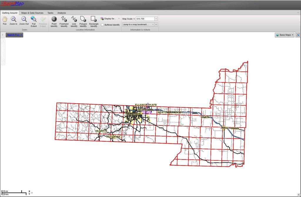
NEW LOOK OF RAPIDMAP! Below is how the RapidMap interface will look when it is initially opened.
|
|
|
- Cory Floyd
- 6 years ago
- Views:
Transcription

1 NEW LOOK OF RAPIDMAP! Below is how the RapidMap interface will look when it is initially opened.
2

3 MAP LAYERS When the arrow to the left of the Search For button is clicked, a Map Layers panel will slide open allowing access to all the layers available within RapidMap. Click on the plus sign to see the layers within each category. If the layer is grayed out it means the layer is not available for viewing at the current map scale. If you click on the grayed out layer a callout box will appear telling you that layers visible scale range. It will give you the option to zoom to the extent the layer would be visible at. (see image below) There are two locations to turn the imagery on: One is in the Map Layers panel and the other is on the Base Maps drop down button in the upper right corner of the map. Something new in this version is the addition of transparency for the imagery. Turn the imagery on and adjust the transparency in the Map Layers panel. At the bottom of the Map Layers panel is a search box. This allows you to search for a particular layer instead of opening up each category. If you are looking for contours, just type contour into the search box. All layers will be cleared from the Map Layers panel except the two available contour layers. Also located at the bottom of the Map Layers panel is the Legend button. Click the button and a legend of currently visible layers will appear.


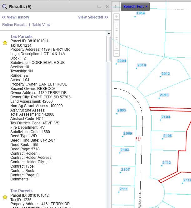
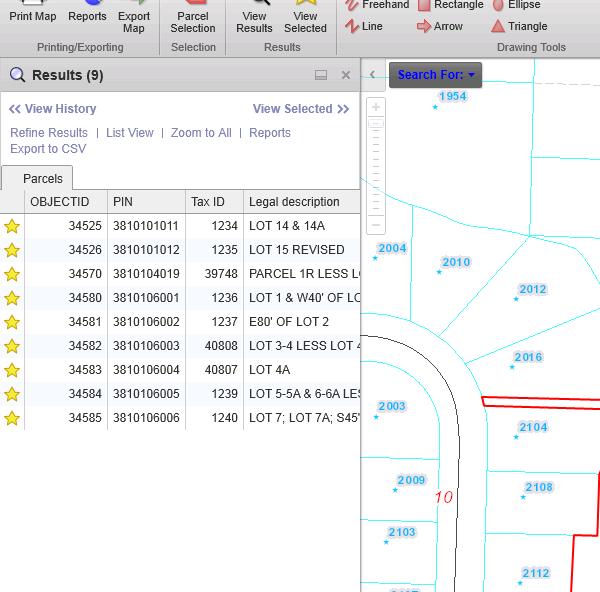
4 SEARCHES Click the Search For drop down to see a list of searches available. Clicking on one of the search options opens up the search panel. Enter the required information and click Search. If there are any results they will show up within the panel. Click just above or below the star of the result to have the map zoom to the location of that result. To view additional information right click the result in the panel and choose Show Feature Details ; or you can double click the result. A box will pop up with the additional fields that can be viewed and any links that may be associated with that layer.
5 AVALIABLE TOOLBARS: Above are all the available tools that can be used within RapidMap. Below is a detailed description of each tool within each toolbar.
6 GETTING AROUND TAB The first 5 tools are ways in which you can get around the map; the titles of the tools are self explanatory. By default the Pan tool is the active tool. The next 3 tools are various ways you can identify a feature on the map. To the right of those tools is a drop down feature called Display For. This drop down allows you to preselect which layers to identify. This can also be done after you have identified a feature by hitting the Refine Results link in the Results panel. By default, the identify tools will identify all visible layers. Below the Display For tab is the Buffered Identify Box. The Buffered Identify check box allows you to identify a distance beyond where you clicked. If this is checked, once you click on the map a box will appear asking how far out you want to identify. The distance is in feet. The next set of tools are the Parcel Selection Tools. These 2 tools allow you to select and identify parcels only. The next tool is the Map Scale drop down. This allows you to select a specific scale, or enter one of your own. The scale is also shown in the bottom left corner of the map. Below the Map Scale drop down is the Jump to Bookmark feature. Here you can jump to a predefined bookmark or you can set one of your own. The user defined bookmark will remain in the list if the browser is reopened. If you delete your temporary internet files the user defined bookmark will be deleted as well. MAPS & DATA SOURCES TAB The Show Layers button does just that. It s an alternate way to access the layers available to view. The Bing and Google buttons allow you to see the photography from those sites for the specific area shown in RapidMap. Zoom to the area you are interested in, then click on one of the buttons. A new window will open showing that same area in either Bing Birds Eye View or Google Street View. If you pan around in Bing or Google then RapidMap will update to keep the 2 sites in sync.
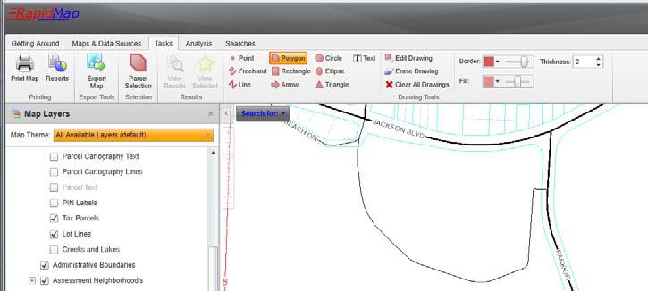
7 TASKS TAB Print Map allows you to create a PDF of a map. The map is complete with a scale, title, disclaimer and legend. The map will open up in a new window. Note that, when returning to RapidMap you will need to close the print map window as this does not close on its own. Next to Print Map is Reports. Currently there are 3 report options: Parcel Report, Information Report and Mailing Labels. There are 3 ways to go about printing a report. If you Identify or Search on a property you can get to the Reports from the Table View (located in the results panel). Another way is to select Reports from the Tasks tab. Choose the report and choose the selection tool. Click the parcel(s) you would like a report on. The 3 rd option is the Parcel Selection tool. This tool works like drawing a polygon. Click once to start your polygon, click again to add additional vertices and double click to end. Just like the identify tools you need to go to the table view and select reports. See the images on the next page. All reports will be in PDF form so you can save them for future use. The next tool is Export Map. This tool allows you to export the map that is currently on your screen. Anything within the map window, graphics and all, will be exported to the file format chosen. There are 5 image formats to choose from. The export will open a new window. You can then save the file at that point by right clicking on the image and choosing Save Picture As. To the right of the Export Map Tool is the Printable Legend. This button allows you to print off a static legend. Click the button once to open up a PDF of a legend that will show all layers that can be displayed on the map. From here you can save the PDF or print it off. The next group of tools are the Drawing Tools. When you select one of the drawing tools you will have some options such as style, size, color, border, etc. For example, with the Polygon tool you can choose the border color and transparency, the fill color and transparency, and the border thickness. Once drawn on the map there are 3 more tools that become active: Edit Drawing, Erase Drawing and Clear All Drawings. Also, a graphics layer will be added to the Map Layers allowing you to turn the drawings on and off after they have been completed. See image on next page.

8
 and click once on the map.")
9 ANALYSIS TAB The first set of tools on the Analysis Toolbar is the Measurement Tools. You have the option to Measure Distance or Measure Area. To Measure Distance or Area, select the Measure Distance button (or the Measure Area button) and click once on the map. Click again to add additional vertices, and then double click to end the line or polygon. The total distance/area is shown in the measurement info on the Analysis Toolbar. Labels are put on to the map automatically. If you want to use a different unit of measurement just go up to the units drop down and select the new one. All measurements will update with the new unit of measurement. To save this measurement, select the Add as Drawing button on the toolbar. This will add a Graphics Layer to the Map Layers panel allowing you to turn the measurements on and off. Next to the Measurement tools are the Coordinate Tools. You can either Enter Coordinates or Plot Coordinates. To Plot Coordinates, just select that tool and click any place on the map. A balloon callout will appear with the coordinates. The coordinate system can also be changed on the fly. For example you can switch from Decimal Degree to Degrees, Minutes, Seconds.
10 TIPS AND TRICKS: When you first open the map the active tool is pan. If you want to zoom in without having to open up the toolbox to select the zoom tool, you can just hold down the shift key and draw a box. The pan tool will still be active after the map zooms in. If you are zoomed into a location on the map and you have the identify tool or any other tool active (will be highlighted orange on the toolbar) and you want to pan around, just hold down the space bar to activate the pan tool. Once you release the spacebar it goes back to the previous active tool. Another way to zoom in and out on the map is with the use of the scroll wheel on your mouse. Moving the mouse wheel towards you will zoom out on the map and moving the mouse wheel away from you will zoom in on the map.
RAPIDMAP Geocortex HTML5 Viewer Manual
 RAPIDMAP Geocortex HTML5 Viewer Manual This site was developed using the evolving HTML5 web standard and should work in most modern browsers including IE, Safari, Chrome and Firefox. Even though it was
OnCOR Silverlight Viewer Guide
 Getting Around There are many ways to move around the map! The simplest option is to use your mouse in the map area. If you hold the left button down, then click and drag, you can pan the map to a new
Getting Started with VicMap
 Getting Started with VicMap This is a brief overview of some of the tools and features available on VicMap. At any time you can right click on the map and click Identify What s Here to find more information
City of La Crosse Online Mapping Website Help Document
 City of La Crosse Online Mapping Website Help Document This document was created to assist in using the new City of La Crosse online mapping sites. When the website is first opened, a map showing the City
Press the Plus + key to zoom in. Press the Minus - key to zoom out. Scroll the mouse wheel away from you to zoom in; towards you to zoom out.
 Navigate Around the Map Interactive maps provide many choices for displaying information, searching for more details, and moving around the map. Most navigation uses the mouse, but at times you may also
Step by Step How to Manual
 www.quintewestmaps.com Step by Step How to Manual Click on to accept the disclaimer and go to the web GIS Step by Step Web Based GIS Interface Layout of Web Based GIS Save your Favorite Map Views Link
Tutorial for Lane County Mapping Applications
 Tutorial for Lane County Mapping Applications Contents Overview... 2 Tools... 2 Navigation Tools... 3 Display Tools... 5 Information Tools... 6 Sharing Tools... 7 Common Tasks... 9 Identify or Show Data
Town of Amherst, NY. GIS Map Machine User Guide. Map Window Search Functions. Help. Toolbar. Layer Control. Scale Bar
 Town of Amherst, NY GIS Map Machine User Guide Toolbar Map Window Search Functions Help Layer Control Scale Bar Map Window Main Elements The MAP WINDOW is the main focus of the screen and where the map
Vertisee Help Interface and Tools VERTISEE HELP. Interface and Tools. McElhanney Consulting Services Ltd Page 1
 VERTISEE HELP Interface and Tools McElhanney Consulting Services Ltd. 2016 Page 1 Contents Browser Interface... 3 Bookmark Tool... 4 Basemap... 5 Coordinate Display Tool... 6 Edit Tool... 7 Find Coordinates
Climate-Smart New Orleans
 Climate-Smart New Orleans Table of Contents GETTING THERE... 2 Accessing the site... 2 Logging into the site... 2 Navigating the Map... 2 Zoom & Pan... 2 Change the map background... 3 Interacting in the
How to use the DuPage County Parcel Viewer Interactive Web Mapping Application.
 How to use the DuPage County Parcel Viewer Interactive Web Mapping Application. Parcel Viewer URL: URL: http://gis.dupageco.org/parcelviewer/ Initial View (And frequently asked questions) Parcel Search
To show toolbars, double-click in the banner at the top or click the tools icon
 8/15/2013 Welcome to Culver City s GIS Property Information Search 2.0. This instructional document provides an overview of most commonly used functionality in this streamlined, enhanced web map application.
Overview of ArcGIS Online Applications. Champaign County
 Overview of ArcGIS Online Applications Champaign County Champaign County GIS Consortium Updated: April 2017 Table of Contents ArcGIS Online Application Overview... 3 Map Interface Symbology and Terminology...
Juniata County, Pennsylvania
 GIS Parcel Viewer Web Mapping Application Functional Documentation June 21, 2017 Juniata County, Pennsylvania Presented by www.worldviewsolutions.com (804) 767-1870 (phone) (804) 545-0792 (fax) 115 South
U N I V E R S I T Y O F K E N T U C K Y. efacts 2-click Interactive Building Information Map ~ Help Guide ~ Revised January 20, 2016
 U N I V E R S I T Y O F K E N T U C K Y efacts 2-click Interactive Building Information Map ~ Help Guide ~ Revised January 20, 2016 Contents BUILDING SEARCH... 3 A. FIND A CAMPUS LOCATION... 3 GRAPHICAL
Greater Bridgeport Regional Council Municipal GIS Viewer Training April 2015
 Greater Bridgeport Regional Council Municipal GIS Viewer Training April 2015 GBRC GIS Web Training Table of Contents Introduction........................................................... 3 Viewer Components.......................................................
Each primary search has an auto-fill that will filter out results as the user continues to type.
 The Town of Farmville has recently requested a GIS parcel viewer and Timmons Group, based out of Richmond, VA, was selected to design and host this new website. This website allows users to look up parcel
PWC County Mapper XM User Instruction (AS OF 12/03/2009)
") PWC County Mapper XM User Instruction (AS OF 12/03/2009) MAP NAVIGATION There are several ways to navigate the map, you can use your keyboard/mouse combination, use the Navigation toolbar, use the slider
PWC County Mapper XM User Instruction (AS OF 12/03/2009) MAP NAVIGATION There are several ways to navigate the map, you can use your keyboard/mouse combination, use the Navigation toolbar, use the slider
USER S MANUAL. ArboWebForest. WebUI
 USER S MANUAL ArboWebForest WebUI i USER'S MANUAL TABLE OF CONTENTS Page # 1.0 GENERAL INFORMATION... 1-1 1.1 System Overview... 1-1 1.2 Organization of the Manual... 1-1 2.0 SYSTEM SUMMARY... 2-1 2.1
Page 1 of 16 CONTENTS:
 Page 1 of 16 CONTENTS: HOME-BOX -- (PG.2) o PROPERTY OWNERSHIP o ADDRESS SEARCH o I WANT TO AERIAL IMAGERY AND BASE MAPS -- (PG.2) o IMAGERY WITH LABELS ON/OFF o TOPOGRAPHY ON/OFF o TRANSPARENCY ZOOM IN
Full Search Map Tab. This map is the result of selecting the Map tab within Full Search.
 Full Search Map Tab This map is the result of selecting the Map tab within Full Search. This map can be used when defining your parameters starting from a Full Search. Once you have entered your desired
Clicking this icon will open the Layer list and will look something like this:
 Webmap Tutorial Last updated: November 17, 2015 To Use the Web map: Open internet browser a. Type in the URL address: i. http://arkcity.maps.arcgis.com/apps/webappviewer/index.html?id=22e0751b74f3411685160c7
City of Richmond Interactive Map (RIM) User Guide for the Public
 User Guide for the Public") Interactive Map (RIM) User Guide for the Public Date: March 26, 2013 Version: 1.0 3479477 3479477 Table of Contents Table of Contents Table of Contents... i About this
Interactive Map (RIM) User Guide for the Public Date: March 26, 2013 Version: 1.0 3479477 3479477 Table of Contents Table of Contents Table of Contents... i About this
Getting Started with the NH Coastal Viewer March, 2015, v0
 Getting Started with the NH Coastal Viewer March, 2015, v0 The NH Coastal Viewer contains a comprehensive user interface with many tools and functions. This document summarizes some of the basic site functionality,
Waushara County Public Access Land Records Viewer Help
 Waushara County Public Access Land Records Viewer Help Main Screen Layout Overview Zoom Pan Controls Parcel Tools Tools Help and Links Image Layers Transition Tools Search Results from Parcel Search Tool
Search Results Tabs. List Tab Options
 Search Results Tabs The Search Results screen is sectioned by tabs. These tabs contain information and tools that are vital in how you configure listing information to package and sell to your clients.
Newaygo County Web Map
 Newaygo County Web Map Address/Parcel/Parcel Owner Search Map Overview Zoom Back to default extent Use your current location if allowable Widget Panel At the top of the map is a search function used for
Biodiversity GIS (BGIS) Internet Mapping User Guide
 Internet Mapping User Guide") Biodiversity GIS (BGIS) Internet Mapping User Guide http://bgis.sanbi.org Contents 1 Basic Introduction to BGIS Website (http://bgis.sanbi.org)... 6 1.1 LUDS... 6 1.2 Projects... 6 1.3 Services... 6 1.4
Biodiversity GIS (BGIS) Internet Mapping User Guide http://bgis.sanbi.org Contents 1 Basic Introduction to BGIS Website (http://bgis.sanbi.org)... 6 1.1 LUDS... 6 1.2 Projects... 6 1.3 Services... 6 1.4
Full Search Map Tab Overview
 FlexMLS Map Server Full Search Map Tab Overview The Full Search Map tab is a need to know module. It is accessible when you use Full Search under Search in the Main Menu tree of FlexMLS. This map can
FAQ & Troubleshooting
 FAQ & Troubleshooting What is the most common issue users have when using the site? Pop-Up Blocker!!! Any link external to the viewer requires a new window to be opened in the browser. See My map or report
Guide to Mapping Website (Public) December 2016 GC_236594
 December 2016 GC_236594") Guide to Mapping Website (Public) December 2016 GC_236594 Table of Contents Guide to Mapping Website (Public)... 1 December 2016... 1 Quick Start... 3 Map Layers... 4 How do I?... 5 Draw on the Map...
Guide to Mapping Website (Public) December 2016 GC_236594 Table of Contents Guide to Mapping Website (Public)... 1 December 2016... 1 Quick Start... 3 Map Layers... 4 How do I?... 5 Draw on the Map...
Read and accept the following disclaimer:
 How to use the Person County Tax Parcel Viewer Visit gis.personcounty.net and click to view the Tax Parcel Viewer or go to gis.personcounty.net/taxparcelviewer Read and accept the following disclaimer:
Using Mapmaker s Toolkit. In this tutorial, you will learn the following basic elements of Mapmaker s Toolkit:
 Using Mapmaker s Toolkit Mapmaker s Toolkit is a useful piece of software that allows you and your students to create customized physical, cultural and historical maps of hundreds of countries, states
COMMISSION OF TEXAS MAY
 GIS Viewer RAILROAD COMMISSION OF TEXAS MAY 2017 Table of Contents GIS Viewer Basics... 1 Basics... 1 Screen Overview... 2 Tools... 5 Visibility... 5 Measure Tool... 7 Identify Tool... 10 Coordinates Tool...
MainStreetMaps Web GIS User Guide
 MainStreetMaps Web GIS User Guide by MainStreetGIS, LLC www.mainstreetgis.com Updated 11/11/2017 Web GIS User Guide - Copyright MainStreetGIS, LLC - www.mainstreetgis.com Page 1 of 15 Table of Contents
A Guide to Using the Planning Office s Interactive Maps
 A Guide to Using the Planning Office s Interactive Maps This guide is intended to assist the user in using the maps provided on the County Planning Office website that are branded as Interactive Maps.
SAGIS Property Map Viewer Instruction Manual Instructions for using the SAGIS Property Map Viewer. Published December 21, 2018.
 SAGIS Property Map Viewer Instruction Manual www.sagis.org/map Instructions for using the SAGIS Property Map Viewer. Published December 21, 2018. 1 Instructional Videos Click on a link to watch a video
Chapter 1 : Getting Started with Integrity... Chapter 2 : Interface Layout... Chapter 3 : Navigation... Chapter 4 : Printing...
 .0 User s Manual Table of Contents Chapter : Getting Started with Integrity... Chapter : Interface Layout... Chapter : Navigation... Chapter : Printing... Chapter : Quick Search and Results Pane... Results
Getting Started with the new GIS Map Service Overview:
 Getting Started with the new GIS Map Service Overview: 1. Layer List Widget Shows all available layers. This widget will be open by default. 2. Legend Widget Gives symbology information for all visible
Viewing the Data 3 Turning Layers On / Off 4 Navigation Toolbar 5 Layout Toolbar 7 Identify Tool 8 Find Tool 10 Measure Tool 12 Go To XY Tool 14
 1 Viewing the Data 3 Turning Layers On / Off 4 Navigation Toolbar 5 Layout Toolbar 7 Identify Tool 8 Find Tool 10 Measure Tool 12 Go To XY Tool 14 Transparency Tool 16 Markup Tools 19 ArcMap Markup Tools
Citizens MapViewer User Manual
 Citizens MapViewer User Manual This guide has been designed with step-by-step instructions to help familiarize you with using the city s Citizens MapViewer. Each of the controls (menus and buttons) is
St. Joseph County. GIS Department FetchGIS Web Map Tutorial
 St. Joseph County GIS Department FetchGIS Web Map Tutorial 2 Table of Contents Contents Slide #(s) Where to Find the Web Map 3 Disclaimer 4 Turning On and Off Map Layers 5 Searching for Parcels 6 More
Explore some of the new functionality in ArcMap 10
 Explore some of the new functionality in ArcMap 10 Scenario In this exercise, imagine you are a GIS analyst working for Old Dominion University. Construction will begin shortly on renovation of the new
Parkland County s Public Interactive Mapping Application USER MANUAL
 Parkland County s Public Interactive Mapping Application USER MANUAL Geographic Information Systems Discover Parkland v3.0 Updated: January 2017 Table of Contents I. Welcome to v3.0... 3 II. Discover Parkland
MANITOBA LAND USE AND DEVELOPMENT WEB APPLICATION: How-to guide and help document
 MANITOBA LAND USE AND DEVELOPMENT WEB APPLICATION: How-to guide and help document 2 Index Index... 2 Layout & View... 3 Overview... 3 Layers... 4 Municipal Relations Data Layers... 4 Application Toolbar...
The Preparing for Success Online Mapping Tool
 The Preparing for Success Online Mapping Tool Baker Polito Administration The Executive Office of Housing and Economic Development and MassGIS Questions & Comments? Please contact MassWorks@state.ma.us
Overview of CCSD Secure Cropper Map
 Overview of CCSD Secure Cropper Map Map Components: 1. Menu Options Use these menus to interact with the map. View School Zones: Use this menu to choose which school zone map to view. Select Students:
Development Authority of the North Country (DANC) Internet Mapping Application Instructions Public Viewer 1. Purpose. 2. Logging-in. 3.
 Internet Mapping Application Instructions Public Viewer 1. Purpose. 2. Logging-in. 3.") Development Authority of the North Country (DANC) Internet Mapping Application Instructions Public Viewer 1. Purpose The purpose of this document is to outline basic functionality of the DANC Internet
Development Authority of the North Country (DANC) Internet Mapping Application Instructions Public Viewer 1. Purpose The purpose of this document is to outline basic functionality of the DANC Internet
Map Functions August 3, 2015 Triangle Homes Group
 Map Functions August 3, 2015 Triangle Homes Group Preston Neighborhoods and Property Map The Map is an interactive web based using ArcGIS Online by ESRI ESRI is the world s largest Geographic Information
IntraMaps End User Manual
 IntraMaps End User Manual For IntraMaps Version 8 Date: 6 th July 2014 Contents Introduction... 4 What is IntraMaps?... 4 Application... 5 Main Toolbar... 6 View... 7 Original View:... 7 Pan:... 7 Zoom
To the GeoView System Overview Online Training Course
 Welcome! To the GeoView System Overview Online Training Course The Alberta Department of Energy provides GeoView as a mapping system to enable users to find geographic information in Alberta. GeoView retrieves
And now the water system should be displayed:
 Webmap Tutorial Last updated: October 14, 2016 To Use the Web map: Open internet browser a. Type in the URL address: i. http://70.167.59.150/internal ii. Save in Favorites tab b. Note: This should work
How to use the DuPageMaps Interactive Web Mapping Application
 How to use the DuPageMaps Interactive Web Mapping Application Interactive Map Link: http://gis.dupageco.org/dupagemaps Helpful Information Initial View Find a parcel in DuPage County, Illinois Map Navigation
MapXpress Help Guide. 282 Main Street Ext. - C2 Middletown, CT
 MapXpress Help Guide 282 Main Street Ext. - C2 Middletown, CT 06457 203 404-7129 Table of Contents 1... Navigation Tools 2... Map Layers: Turning On and Off Data Layers 3... Searching By Name, Address,
FlexMLS Maps Quick Reference Guide
 FlexMLS Maps Quick Reference Guide Full Search Map Tab Features Define Search Areas box Map tab in Full Search Radius Search tool from an address Show/Hide Property List, Locate Address, and Define Search
Peoria County Front Desk Map Application
 Peoria County Front Desk Map Application Quick Guide, 2017 At a First Glance This guide will tell users all they need to know about the Peoria County Front Desk application which can be found on the Peoria
- Hold down the 'Shift' key and click and drag the mouse to create a red box which will zoom to that area when released.
 Basic navigation and zoom: To Pan around the map: - Click anywhere on the map and hold the button down until 4 directional arrows appear which will then allow the mouse to be moved in any direction panning
Estuary Data Viewer User Guide
 1. Introduction 2. Page Layout 3. Navigation Tools 4. Table of Contents Tabs 5. Action Tools 6. System Requirements Estuary Data Viewer User Guide 1. Introduction Welcome to the Estuary Planner Data Viewer.
Greenville County Internet Mapping System User s Guide
 Greenville County Internet Mapping System User s Guide Version 2.0 Greenville County Geographic Information Systems May 30, 2006 Table of Contents NAVIGATING TO THE ONLINE MAPPING APPLICATIONS...- 3 -
_Tutorials. Arcmap. Linking additional files outside from Geodata
 _Tutorials Arcmap Linking additional files outside from Geodata 2017 Sourcing the Data (Option 1): Extracting Data from Auckland Council GIS P1 First you want to get onto the Auckland Council GIS website
QUICK REFERENCE GUIDE. VISIT Internet:
 ZIMAS QUICK REFERENCE GUIDE VISIT US @ Internet: http://zimas.lacity.org ABOUT ZIMAS In our continuing effort to improve the delivery of services to the public, the Department of City Planning developed
Mn/DOT MnCMAT Crash Analysis Application Help
 Mn/DOT MnCMAT Crash Analysis Application Contents Login... 5 User Login Dialog... 5 Login... 5 Request Access Dialog... 5 Forgotten Password Dialog... 6 Create/Open Project... 7 Create/Open Project Dialog...
Municipal Connect TM GIS Viewer
 Municipal Property Assessment Corporation 1305 Pickering Parkway Pickering, ON L1V 3P2 For further information please contact your local MPAC Municipal Relations Representative. Municipal Connect TM GIS
ISV Map Site Tools. 21 March 2012 Page 1 of 5
 ISV Map Site Tools Upon initial load of the ISV Map Site, the Header bar, which displays Client specific details for the purpose of the site, slides down to reveal information. Then, after a short delay,
Lucas County Engineer s GIS Maps User Guide
 Lucas County Engineer s GIS Maps User Guide The Web Map Interface On the left hand side of the screen, you will see the Legend of the layers shown in the map. If you click on Details, you will see just
COGCC GIS Online Map Instructions - Internet Site April 10, 2018
 COGCC GIS Online Map Instructions - Internet Site April 10, 2018 Table of Contents Page Section Page Section 1 Introduction 8 Clear Selection 2 Double Click 8 Buffer 3 Arrow Tip Information 9 Select within
Fundisa Web Map Applications
 Fundisa Web Map Applications 2013-01-09 Prepared by SANSA Earth Observation 1 Using the SANSA Fundisa Web Map Applications The Fundisa web map applications were created to aid students in their search
User Manual Mobile client User Interface Version 5.0. Powered by
 User Manual Mobile client User Interface Version 5.0 Powered by Cartographic browser Gomap 4 1 Access control 5 1.1 Public access 5 1.2 Secured access 5 1.3 Multiple applications 5 2 Organisation 6 3 Parameters
Map Viewer User Guide
 Map Viewer User Guide Sea Level Scenario Sketch Planning Tool Version 2, 2017 University of Florida GeoPlan Center Introduction The purpose of this document is to guide users on how to use the Sea Level
Using Google Earth Pro
 Using Google Earth Pro (v7.3.2) University of Toronto Mississauga Library Hazel McCallion Academic Learning Centre October 2018 FURTHER ASSISTANCE If you have questions or need assistance contact Tanya
Microsoft PowerPoint 2013 Beginning
 Microsoft PowerPoint 2013 Beginning PowerPoint Presentations on the Web... 2 Starting PowerPoint... 2 Opening a Presentation... 2 File Tab... 3 Quick Access Toolbar... 3 The Ribbon... 4 Keyboard Shortcuts...
INTERACTIVE MAP TUTORIAL
 Wisconsin Breeding Bird Atlas II INTERACTIVE MAP TUTORIAL General Information There are two versions of the map, the PC Desktop Version, and the Mobile/Mac Version. Most of this guide will assume you are
Open Source Cloud Map User Guide
 Open Source Cloud Map User Guide Table of Contents Map Page... 1 Static Mercator Map... 1 Customizable Map... 1 Title Bar... 2 Toolbar... 2 Non Toolbar Navigation... 3 Map Window... 3 Layers / Legend Window...
Using Syracuse Community Geography s MapSyracuse
 Using Syracuse Community Geography s MapSyracuse MapSyracuse allows the user to create custom maps with the data provided by Syracuse Community Geography. Starting with the basic template provided, you
REDI 5.0 User Manual
 REDI 5.0 User Manual OBJECTIVE: REDI (Regional Economic Development Information System) provides a quick, convenient and easy way of accessing the City of San Diego Business Incentive Zones (BIZ) information.
Exercise 1: An Overview of ArcMap and ArcCatalog
 Exercise 1: An Overview of ArcMap and ArcCatalog Introduction: ArcGIS is an integrated collection of GIS software products for building a complete GIS. ArcGIS enables users to deploy GIS functionality
Guide to Bruce County Maps (Public) January 2018
 January 2018") Guide to Bruce County Maps (Public) January 2018 For any unanswered questions about Bruce County Maps not covered by this document, please contact Justin Kraemer at gis@brucecounty.on.ca or phone 519-534-2092
Guide to Bruce County Maps (Public) January 2018 For any unanswered questions about Bruce County Maps not covered by this document, please contact Justin Kraemer at gis@brucecounty.on.ca or phone 519-534-2092
How to do a Property Search
 How to do a Property Search A Self-Tutorial GIS Services 1401 Marina Way South Richmond, CA 94804 Tel: (510) 621-1298 Fax: (510) 307-8116 1. Navigate to the GIS Mapping Services page. 2. The mapping services
Web Viewer Guide. HiPER LOOK Version Copyright 2016 PIXIA Corp. All Rights Reserved.
 Web Viewer Guide 2016 HiPER LOOK Version 1.4.16.0 Copyright 2016 PIXIA Corp. All Rights Reserved. Table of Contents 1 System Requirements... 5 1.1 Prerequisites... 5 1.2 Web Browser... 5 2 HiPER LOOK Web
Acrobat X Professional
 Acrobat X Professional Toolbar Well Page Navigations/Page Indicator Buttons for paging through document Scroll Bar/box page indicator appears when using the scroll button to navigate. When you release
How To Guide for Using Maryland Incentive Zone Interactive Map
 How To Guide for Using Maryland Incentive Zone Interactive Map http://www.dhcd.state.md.us/gis/revitalize/index.html Purpose This How To guide is intended to: Determine if addresses are located within
User Guide. ExploreHRM ICT BIDS. 0 P a g e
 User Guide ICT BIDS 0 P a g e Contents Introduction... 2 Top Left Panel Navigation and Search Widgets... 3 Search... 3 Zoom In/Out... 3 Home... 3 Zoom Extent... 3 Right Panel Information and Print Widgets...
Working with PDF s. To open a recent file on the Start screen, double click on the file name.
 Working with PDF s Acrobat DC Start Screen (Home Tab) When Acrobat opens, the Acrobat Start screen (Home Tab) populates displaying a list of recently opened files. The search feature on the top of the
FrontCounter BC Discovery Tool Instructions. NOTE: You must have Google Earth installed to use this tool.
 NOTE: You must have Google Earth installed to use this tool. These instructions are written for use with a Microsoft Windows Work Station. This tutorial will step you through navigating to and viewing
Manitowoc County, WI Advanced Access GIS Viewer User Documentation
 Manitowoc County, WI Advanced Access GIS Viewer User Documentation Introduction Extensive time was put into developing this website both from a display, and from a printing and scaling perspective. This
User s Guide: BIOS Online Mapping Tool to access the California Freshwater Species Database
 User s Guide: BIOS Online Mapping Tool to access the California Freshwater Species Database Last updated: December 2017 Tutorial created by: The Nature Conservancy Topics covered Part 1: Exporting a tabular
LeeSpInS 2.0 Help Guide
 LeeSpInS 2.0 Help Guide http://leegis.leegov.com/leespins/ E-mail us at gis@leegov.com with any questions or issues using this site Navigation Tools Pan arrows scroll the map in the arrow direction or
COGCC GIS Online Map Tools-Intranet Site July 12, 2011
 COGCC GIS Online Map Tools-Intranet Site July 12, 2011 Table of Contents Page Section Page Section 1 Introduction 7 Clear Selection 2 Double Click 7 Buffer 2 Arrow Tip Information 8 Select within 3 Busy
13/02/2008. Users guide RoofCon Viewer
 Users guide RoofCon Viewer Table of contents Users guide RoofCon Viewer... 1 Table of contents... 2 Installation... 3 Select object... 3 Zoom... 3 Measure distance... 3 Toolbar and Drawing preferences...
Office of Geographic Information Systems
 Office of Geographic Information Systems Print this Page Fall 2012 - Working With Layers in the New DCGIS By Kent Tupper The new version of DCGIS has access to all the same GIS information that our old
This guide will tell you all you need to know about the new Front Desk application which can be found on the main Peoria County GIS website.
 New Front Desk Quick Guide, 2014 At a First Glance This guide will tell you all you need to know about the new Front Desk application which can be found on the main Peoria County GIS website. When you
Vectorworks Essential Tutorial Manual by Jonathan Pickup. Sample
 Vectorworks Essential Tutorial Manual by Jonathan Pickup Table of Contents 0.0 Introduction... iii 0.1 How to Use this Manual... iv 0.2 Real World Sizes... iv 0.3 New Ways of Drawing... v 1.0 Introduction
Butler County Property Ownership Website. Help Document
 Table of Contents Butler County Property Ownership Website Help Document Introduction... 1 Overview of Home Page... 1 Navigation & Tools... 2 Upper Right:...4 Layer List... 4 Draw... 4 Measurement... 6
1. NJDEP Landscape 3.3 Viewer Interface
 Using the Landscape Project through NJDEP Landscape 3.3 Viewer Google Chrome or Mozilla Firefox are recommended for the use of this app. Navigate to the NJDEP-DFW s Landscape Project web page at www.njfishandwildlife.com/ensp/landscape/
imaps v2 QUICKSTART GUIDE
 imaps v2 QUICKSTART GUIDE http://maps.raleighnc.gov/imaps/index.html Search for Condo Units new! You can now search for individual condo records when you search by address in the property search. Or, select
Scoilnet Maps Help. Introduction. Map Canvas. Mapping. Contents
 Scoilnet Maps Help Contents Introduction Map Canvas Mapping Widgets Navigation Searching for Addresses Layer Control and Legend Popup Windows Export to PDF Printing Draw Widget Bookmarks Widget Swipe/Spotlight
GEOCIRRUS 3D Viewer. User Manual: GEOCIRRUS 3D Viewer Document version 1.6 Page 1
 GEOCIRRUS 3D Viewer Page 1 Table of Contents 3D Viewer Functionality... 3 Line of Sight (LoS)... 4 Identify... 8 Measurement... 9 3D Line Measure Tool... 10 3D Area Measure Tool... 11 Environment... 12
Livingston County MAP User Guide
 Livingston County MAP User Guide Need help with the Livingston County MAP? Click the button located on each tool s window to view the help documentation for that specific tool. If you need additional information
The University of Arizona
 1 The University of Arizona Campus 360 Web Map Help Guide v 1.3.1 Revised Aprils 2018 https://maps.arizona.edu/campus360/ 2 CONTENTS INTRODUCTION MAP CONTROLS Zoom in, zoom out...p. 4 Map Control toolbar
Vizit Essential for SharePoint 2013 Version 6.x User Manual
 Vizit Essential for SharePoint 2013 Version 6.x User Manual 1 Vizit Essential... 3 Deployment Options... 3 SharePoint 2013 Document Libraries... 3 SharePoint 2013 Search Results... 4 Vizit Essential Pop-Up