ArcGIS Server: publishing geospatial data to the web using the EEA infrastructure
|
|
|
- Kristin Cook
- 6 years ago
- Views:
Transcription
1 ArcGIS Server: publishing geospatial data to the web using the EEA infrastructure *IMPORTANT: Map Services should be published using the EEA Map Services Tick Sheet for guidance. Contact Sebastien Petit to receive the tick sheet if you don t have it. Each time a Map Service is published a filled tick sheet should be ed to him. Introduction ArcGIS server is used to host advanced geospatial web services (examples include the Natura 2000 viewer, Corine Land Cover) as well as more data heavy map services and datasets. Partners operating outside of the agency can publish remotely to the servers if they have a desktop version of ArcMap (version 10.1 or higher). To keep this guide simple we will focus on the publication of map services. Feature services and Image tiling services can also be produced in the same way. For extended information about ArcGIS Server please visit or contact someone at IDM3. IMPORTANT: when to use ArcGIS Server to publish geospatial data You can always use ArcGIS Server to publish your data to the web. ArcGIS server provides a powerful, developer orientated platform to host advanced geospatial applications. But in case your dataset is small and you need to quickly share it, it might be worth doing so in ArcGIS Online. ArcGIS online is a great place to host and share web maps, feature services and small datasets. To quickly upload and share small datasets please refer to the ArcGIS Online: publishing geospatial data to the web using the EEA infrastructure document. To be able to upload to the EEA, first you need to be given access rights. To gain access rights you should your EEA project manager and CC Sebastien Petit (Sebastien.Petit@eea.europa.eu) stating your Eionet account, EEADMZ1 or EEA account username. ArcGIS Server Publishing map services Publishing map services is simple in the latest version of Arc Map. The EEA has a number of guidelines to follow. From experience we learned that we should scale down to what we support. Guideline 1: Data Types The EEA requires that you prepare your data initially into File Geodatabase format for vector data, or TIFF data for raster data. To convert a shapefile (vector) into a File Geodatabase feature class is a simple 1

2 matter. First in ArcMap or Arc Catalog, use the catalog tree to navigate to your workspace. Then right click > new > file geodatabase. You should rename the file Geodatabase, and then you can export your shapefile to the file geodatabase by right clicking on the shapefile in your map document table of contents > Data > Export Data > Locate your file geodatabase and export. To convert raster data from other formats to TIFF, the idea is the same. Right click on the data layer in the table of contents, export. You can then select the export folder and change the format to TIFF. It is important that you follow this data rule as it is enforced to keep the EEA services running optimally. All other formats will be systematically removed by our GIS administrator. 2
 has subfolders data for the source data, map for the mxd map document and doc containing any readme information Map")
 Give your layers clear names.")
3 Guideline 2: Map Document: We also require the data to be saved in an.mxd map document that structures and represents the data properly. It is best if you structure your folders so that the project folder (root) has subfolders data for the source data, map for the mxd map document and doc containing any readme information Map documents can have many structures but we advise you to follow these guidelines. 1) Re project your content into Web Mercator (WGS_1984_Web_Mercator_Auxiliary_Sphere) projection. Most API s Google, ArcGIS, Bing use this projection. The map may look wrong if you do not do this. It will improve the performance drastically. 2) Give your layers clear names. The web services need to be understood easily. 3) Group what belongs together. For example if you need to layout on different scales make sure those layers are grouped together. 3

4 4) Scale dependencies should always be the last grouping. Make it possible to show the layer at all scales by including always a layer that is visible in the display and extra layers that are by default turned off (whenever the scale is outside the layer's visible scale range). 5) Groups turned off should show something when turned on. Meaning that some or all of the underlaying layers should be turned on. 6) Make field names readable by giving aliases. For example you may want to create an alias for a field called c_code to Country Code to make it more easily understandable In ArcMap right click on the layer and use properties. Go to the Fields tab and type an alias for every field to make it readable. 7) Turn off those fields not relevant to the map service. IMPORTANT: if your web services needs to be queried and return the geometry, the SHAPE field should not be unchecked from the list. 4
 9) Remove any base map or background information not part of the map content. Map services are merged together into a web map at a later stage.")
5 8) For code lists use domains to give proper naming. In ArcCatalog right click on the database and select properties. Add the domains as lookup tables. (Make sure you use the same field type) 9) Remove any base map or background information not part of the map content. Map services are merged together into a web map at a later stage. A base map is added from ArcGIS online. 10) If you have tables with data in them that you want to include, also drag them into the mxd. 5

6 Guideline 3: Metadata Once your map is tested and functional you are ready to write metadata. In order to achieve environmental protection goals, in the long term and broad scale, huge amount of data is needed to be retrieved, stored and analysed. Metadata contains information needed to understand, manage and effectively use this data. So it is very important to write the metadata of the map you are going to publish. In order to reuse your map, users will need, at least, to know who created the map, when it was created and the purpose. 1) Please check that your MXD data frame has an appropriate name and it s not set to the default value, Layers. Also the description of the map will be shown in the Rest ArcGIS Services. Like in the picture below, right click in the data frame, located as the heading of the Table Of Contents in ArcMap. 6
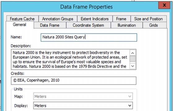
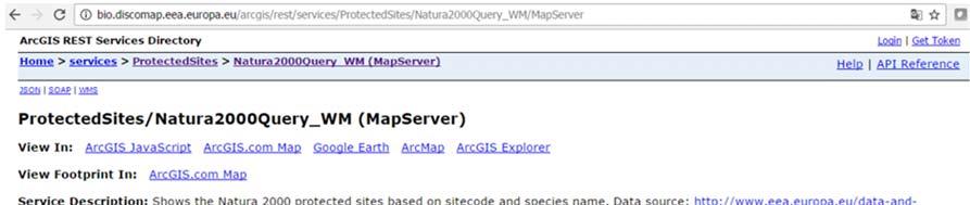
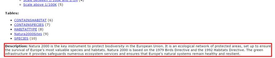
7 The Name corresponds to the Map Name, the Description to Description. 7

 Create metadata for your ArcGIS map service by filling the appropriate fields of the MXD metadata.")
8 2) Please check that each of the datasets included in your map already contains comprehensive metadata. To find out if a particular layer has metadata, you can search the source layer in ArcCatalog, right click the layer and display the item information. In Europe, geographic stored data layers should be documented with INSPIRE compliant metadata, although there are other formats (ARCGIS, ISO19139 standard, American FGDC). 3) Create metadata for your ArcGIS map service by filling the appropriate fields of the MXD metadata. If you fill in the metadata fields for your map project (mxd) these then will be published within your map service. There are several formats to store metadata. For map services, none of them are required (they have been designed for data sources), but to harmonize metadata procedures, it will be helpful to use the most common metadata fields and use the INSPIRE version inside ArcCatalog by going into Customize > ArcCatalog Options. Select Metadata and in the Metadata Style select INSPIRE Metadata Directive. 8
9 Then right click the MXD file in the ArcCatalog window within ArcMap and select Item Description. Once the window pops up, please click Edit to proceed (notice you have options to export and import metadata for similar services, which can be helpful too if you have similar services). There are many fields and not all are mandatory. The minimum we ask is for you to fill in the Item Description, which include Title, Tags, Summary, Description and Credits, Topic & Keywords and Metadata Contacts. 9

10 When clicking in any of the fields it might be of aid to notice that there is a description or a small text at the bottom of the editing window to help you filling in the information. 10


11 Guideline 4: Publishing The agency wants to roll out its publishing plan in a series of gradual steps so that we can safeguard our data, services and servers. To do this initially the EEA requires users to publish everything to the test environment. Datasets will then be moved by our administrators into our production environment. Registering an ArcGIS server using the EEA s infrastructure You will need an EIONET account with publishing privileges to gain access to this. 1) In ArcCatalog go under GIS Servers and press Add ArcGIS Server 2) Select Publish GIS Services and press Next 11


12 3) Type the server Url this will be to the test environment such as Make sure that User ArcGIS Desktops Staging Folder is selected. Enter your Eionet credentials and Press Finish. At this moment, you should have EEA server registered to your ArcCatalog. 4) Double click to see if you can access the content of the new ArcGIS Server added. You should see something like this. 12

 Select the server to publish the content towards (the test server you just added),")
13 Publish your map to EEA s infrastructure. Open the map you created and follow the following steps. 1) In ArcMap go to File > Share As > Services 2) Select Publish as a Service and press Next 3) Select the server to publish the content towards (the test server you just added), create a service name and press Next. Make the service name easily understandable. 13
14 4) Select the agreed folder you can publish under and press Next. TIP: You might want to import the settings of other similar service already published. Click the Import button at the top of the window (see image above). This will affect capabilities, item description and other properties of the service. Be sure to change relevant properties or description before clicking the publish button! 5) Go to Capabilities and check WMS and WFS if applicable. 6) Check the Item Description and check if all content is filled. 7) Press the Analyse button. It will list you a number of issues if you have issues. Most of the time a Data source is not registered would be shown. This is normal as we expect you to upload the data to the server. (In large data cases, please contact the EEA) 8) Press the Publish button and your service will be packaged and uploaded to the EEA s infrastructure. Your map has now been published and can be used inside ArcGIS online. Check your service using the published URL for example Follow EEA on Facebook or Twitter or through Discomap for updates. 14
How to Create a Tile Package
 United States Department of Agriculture Digital Mobile Sketch Mapping (DMSM) How to Create a Tile Package (TPK) Forest Service Introduction A tile package (.tpk) allows you to use a set of packaged tiles
ArcMap - EXPLORING THE DATABASE Part I. SPATIAL DATA FORMATS Part II
 Week 5 ArcMap - EXPLORING THE DATABASE Part I SPATIAL DATA FORMATS Part II topics of the week Exploring the Database More on the Table of Contents Exploration tools Identify, Find, Measure, Map tips, Hyperlink,
How to Create Metadata in ArcGIS 10.0
 How to Create Metadata in ArcGIS 10.0 March 2012 Table of Contents Introduction... 1 Getting Started... 2 Software Requirements... 2 Configure ArcGIS Desktop to View FGDC Metadata... 2 Other Thoughts...
Spatial Data Standards for Facilities, Infrastructure, and Environment (SDSFIE)
") Spatial Data Standards for Facilities, Infrastructure, and Environment (SDSFIE) Migration Workflow User Guide Version 1.0 (01 August 2018) Prepared For: US Army Corps of Engineers 2018 Revision History
Spatial Data Standards for Facilities, Infrastructure, and Environment (SDSFIE) Migration Workflow User Guide Version 1.0 (01 August 2018) Prepared For: US Army Corps of Engineers 2018 Revision History
Exercise 1: An Overview of ArcMap and ArcCatalog
 Exercise 1: An Overview of ArcMap and ArcCatalog Introduction: ArcGIS is an integrated collection of GIS software products for building a complete GIS. ArcGIS enables users to deploy GIS functionality
Accessing OGC Services To access OGC WMS and WFS open the service in the directory that you want to consume, and click on either WMS or WFS.
 Using Web Services Web Services Overview This user guide contains instructions on how to consume a range of services through a range of both web based and desktop GIS applications. Web services are a live
Answer the following general questions: 1. What happens when you right click on an icon on your desktop? When you left double click on an icon?
 Name: Date: June 27th, 2011 GIS Boot Camps For Educators Practical: Explore ArcGIS 10 Desktop Tools and functionality Day_1 Lecture 1 Sources: o ArcGIS Desktop help o ESRI website o Getting to Know ArcGIS
Geography 281 Mapmaking with GIS Project One: Exploring the ArcMap Environment
 Geography 281 Mapmaking with GIS Project One: Exploring the ArcMap Environment This activity is designed to introduce you to the Geography Lab and to the ArcMap software within the lab environment. Please
Review of File Management and Introduction to ArcGIS
 Review of File Management and Introduction to ArcGIS RNR/GEOG 417/517 Overview of Presentation Discuss the objectives of the lab exercise Introduce the class directory structure General file policies Introduce
Geography 281 Mapmaking with GIS Project One: Exploring the ArcMap Environment
 Geography 281 Mapmaking with GIS Project One: Exploring the ArcMap Environment This activity is designed to introduce you to the Geography Lab and to the ArcMap software within the lab environment. Before
FAQ & Troubleshooting
 FAQ & Troubleshooting What is the most common issue users have when using the site? Pop-Up Blocker!!! Any link external to the viewer requires a new window to be opened in the browser. See My map or report
Geospatial Databases: Metadata, Standards, and Infrastructure
 Geospatial Databases: Metadata, Standards, and Infrastructure What is metadata? Information that describes items in ArcGIS is called metadata. When care is taken to provide good descriptions, you can find
Best Practices for Designing Effective Map Services
 FedGIS Conference February 24 25, 2016 Washington, DC Best Practices for Designing Effective Map Services James Tedrick, Esri Matt Sokol, MD Dept. of Information Technology Web Mapping & Service Types
Chapter 3 The project
 Chapter 3 The project Background ArcGIS Pro organizes the user experience with data in a completely different way from ArcMap, through a construct known as a project. What is a project? The project is
Introduction to ArcCatalog
 Introduction to ArcCatalog Introduction To Arc Catalog ArcCatalog is a data- centric GUI tool used for managing spatial data With ArcCatalog you can. Inspect properties and attributes of data Preview and
Geographical Information Systems Institute. Center for Geographic Analysis, Harvard University. LAB EXERCISE 1: Basic Mapping in ArcMap
 Harvard University Introduction to ArcMap Geographical Information Systems Institute Center for Geographic Analysis, Harvard University LAB EXERCISE 1: Basic Mapping in ArcMap Individual files (lab instructions,
SilvAssist 3.5 Instruction Manual Instruction Manual for the SilvAssist Toolbar For ArcGIS. Version 3.5
 Instruction Manual for the SilvAssist Toolbar For ArcGIS Version 3.5 1 2 Contents Introduction... 5 Preparing to Use SilvAssist... 6 Polygon Selection... 6 Plot Allocator... 7 Requirements:... 7 Operation...
LAB 1: Introduction to ArcGIS 8
 LAB 1: Introduction to ArcGIS 8 Outline Introduction Purpose Lab Basics o About the Computers o About the software o Additional information Data ArcGIS Applications o Starting ArcGIS o o o Conclusion To
GEOG4017 Geographical Information Systems Lab 3 Data Collection and Integration (I)
") DEPARTMENT OF GEOGRAPHY HONG KONG BAPTIST UNIVERSITY Prof. Q. Zhou GEOG4017 Geographical Information Systems Lab 3 Data Collection and Integration (I) Objectives Before we can use GIS for any analysis
DEPARTMENT OF GEOGRAPHY HONG KONG BAPTIST UNIVERSITY Prof. Q. Zhou GEOG4017 Geographical Information Systems Lab 3 Data Collection and Integration (I) Objectives Before we can use GIS for any analysis
Map Direct Lite. Quick Start Guide: Map Layers 5/14/2018
 Map Direct Lite Quick Start Guide: Map Layers 5/14/2018 Contents Quick Start Guide: Map Layers... 1 Map Layers in Map Direct Lite.... 3 What is a Basemap Layer?... 4 Change the Basemap Using the Basemap
Create a personal geodatabase
 Create a personal geodatabase To create a personal geodatabase that corresponds to the same release as the ArcGIS for Desktop client you are using, follow these steps: 1. In ArcCatalog, right-click the
CONTENTS 1 INTRODUCTION 3 ARCGIS 5 START ARCMAP 11 IMPORT 1: MAP DATA 12 ADD WIND FARM DATA 21 CREATE A MAP TO INSERT IN A REPORT 32
 CONTENTS CONTENTS 1 INTRODUCTION 3 SCENARIO 3 WHAT WILL I LEARN? 3 WHAT DATA DO I HAVE? 4 ARCGIS 5 ARCMAP 6 ARCCATALOG 8 ARCTOOLBOX 9 START ARCMAP 11 IMPORT 1:250000 MAP DATA 12 CREATE A GROUP LAYER 16
Streamlining Editing Workflows. Amber Bethell
 Streamlining Editing Workflows Amber Bethell Workflow for solving geographic problems Ask a question Create or acquire data Validate and update data Analyze data Create cartographic product Act upon knowledge
BIO8014 GIS & Remote Sensing Practical Series. Practical 1: Introduction to ArcGIS Desktop
 BIO8014 GIS & Remote Sensing Practical Series Practical 1: Introduction to ArcGIS Desktop 0. Introduction There are various activities associated with the term GIS, these include visualisation, manipulation
Creating and Editing a New Shapefile
 Creating and Editing a New Shapefile Written by Barbara Parmenter, revised October, 0 CREATING AND EDITING A NEW SHAPEFILE... CREATING THE GEOGRAPHIC FEATURE (POINT, LINE, OR POLYGON)... CREATING THE ATTRIBUTE
Name: Date: June 27th, 2011 GIS Boot Camps For Educators Lecture_3
 Name: Date: June 27th, 2011 GIS Boot Camps For Educators Lecture_3 Practical: Creating and Editing Shapefiles Using Straight, AutoComplete and Cut Polygon Tools Use ArcCatalog to copy data files from:
Introduction to Geographic Information Systems Spring 2016
 Introduction to Geographic Information Systems Spring 2016 Exercise 2 Introduction to ArcGIS 10 Projects This exercise will introduce you to the common set-up functions of the ESRI ArcGIS software package.
Multi-LCC Mississippi River Basin Gulf Hypoxia Initiative. ScienceBase and Data Basin User Guide
 Multi-LCC Mississippi River Basin Gulf Hypoxia Initiative ScienceBase and Data Basin User Guide Data delivery for the Gulf Hypoxia Initiative is carried out through the use of two websites: ScienceBase
Lesson 8 : How to Create a Distance from a Water Layer
 Created By: Lane Carter Advisor: Paul Evangelista Date: July 2011 Software: ArcGIS 10 Lesson 8 : How to Create a Distance from a Water Layer Background This tutorial will cover the basic processes involved
Interactive Maps Purpose: Login to the System: Interactive Maps ONTINUE AGREE
 Interactive Maps Purpose: The purpose of this application is to provide the facility to the citizen to navigate to a Property through an On-line Free Web Application in real time. The application uses
ESRI stylesheet selects a subset of the entire body of the metadata and presents it as if it was in a tabbed dialog.
 Creating Metadata using ArcCatalog (ACT) 1. Choosing a metadata editor in ArcCatalog ArcCatalog comes with FGDC metadata editor, which create FGDC-compliant documentation. Metadata in ArcCatalog stored
Advanced PDF features
 1 of 7 2/17/2009 10:56 PM Show Navigation Hide Navigation You are here: Mapping and v isualization > Page layout and map composition > Map output Advanced PDF features Release 9.3 Last modified November
Spatial Data Standards for Facilities, Infrastructure, and Environment (SDSFIE)
") Spatial Data Standards for Facilities, Infrastructure, and Environment (SDSFIE) Model Builder User Guide Version 1.3 (24 April 2018) Prepared For: US Army Corps of Engineers 2018 Revision History Model
Spatial Data Standards for Facilities, Infrastructure, and Environment (SDSFIE) Model Builder User Guide Version 1.3 (24 April 2018) Prepared For: US Army Corps of Engineers 2018 Revision History Model
Downloading shapefiles and using essential ArcMap tools
 CHAPTER 1 KEY CONCEPTS downloading shapefiles learning essential tools exploring the ArcMap table of contents understanding shapefiles customizing shapefiles saving projects Downloading shapefiles and
SSURGO Processing Tool
 SSURGO Processing Tool User Guide (Revised 08.02.11) Software Requirements: Setup_SWATioTools_094.exe Windows XP or Windows 7 32-bit with MS Office 2007 (Access and Excel) ArcGIS 9.3.1 SP2 Instructions
Getting to Know ModelBuilder
 Getting to Know ModelBuilder Offered by Shane Bradt through the UNH Cooperative Extension Geospatial Technologies Training Center Developed by Sandy Prisloe and Cary Chadwick at the Geospatial Technology
Select the Parks within Forest Acres
 Select the Parks within Forest Acres TASKS RESULT 1. Add the county boundary, municipalities and parks (pts.) layers to your map 2. Save your map (.mxd) to your desktop Your map should look something like
Tutorial 1: Finding and Displaying Spatial Data Using ArcGIS
 Tutorial 1: Finding and Displaying Spatial Data Using ArcGIS This tutorial will introduce you to the following: Websites where you may browse to find geospatial information Identifying spatial data, usable
GIS Basics for Urban Studies
 GIS Basics for Urban Studies Date: March 21, 2018 Contacts: Mehdi Aminipouri, Graduate Peer GIS Faciliator, SFU Library (maminipo@sfu.ca) Keshav Mukunda, GIS & Map Librarian Librarian for Geography (kmukunda@sfu.ca)
Compass INSPIRE Services. Compass INSPIRE Services. White Paper Compass Informatics Limited Block 8, Blackrock Business
 Compass INSPIRE Services White Paper 2010 Compass INSPIRE Services Compass Informatics Limited Block 8, Blackrock Business Park, Carysfort Avenue, Blackrock, County Dublin, Ireland Contact Us: +353 1 2104580
DATA SHARING AND DISCOVERY WITH ARCGIS SERVER GEOPORTAL EXTENSION. Clive Reece, Ph.D. ESRI Geoportal/SDI Solutions Team
 DATA SHARING AND DISCOVERY WITH ARCGIS SERVER GEOPORTAL EXTENSION Clive Reece, Ph.D. ESRI Geoportal/SDI Solutions Team Geoportal Extension for ArcGIS Server Context within an Enterprise Spatial Data Infrastructure
NATIONAL GEOPORTAL USER GUIDE
 NATIONAL GEOPORTAL USER GUIDE National Spatial Data Management Division January 2016 TABLE OF CONTENTS GENERAL OVERVIEW... 1 ABOUT THIS MANUAL... 2 ACCESSING THE GEOPORTAL... 3 ADDING DATA TO THE GEOPORTAL...
Accessing AIM Data. Instruction Manual. Connecting to AIM Data: TerrADat: Terrestrial AIM Database LMF: Landscape Monitoring Framework Database
 Accessing AIM Data Instruction Manual Connecting to AIM Data: TerrADat: Terrestrial AIM Database LMF: Landscape Monitoring Framework Database Created by: BLM National Operations Center Version 1.4 June
GIS LAB 1. Basic GIS Operations with ArcGIS. Calculating Stream Lengths and Watershed Areas.
 GIS LAB 1 Basic GIS Operations with ArcGIS. Calculating Stream Lengths and Watershed Areas. ArcGIS offers some advantages for novice users. The graphical user interface is similar to many Windows packages
2) Make sure that the georeferencing extension is on by right-clicking in the task bar area and selecting Georeferencing
 Make sure that the georeferencing extension is on by right-clicking in the task bar area and selecting Georeferencing") HGIS Workshop Module 1 Georeferencing Large Scale Scanned Historical Maps Objective: Learn the Principles of Georeferencing 1) In ArcMap, open the project 01 data\arcdata_10_1\arcdata\toronto\georeference.mxd
HGIS Workshop Module 1 Georeferencing Large Scale Scanned Historical Maps Objective: Learn the Principles of Georeferencing 1) In ArcMap, open the project 01 data\arcdata_10_1\arcdata\toronto\georeference.mxd
INSPIRE: The ESRI Vision. Tina Hahn, GIS Consultant, ESRI(UK) Miguel Paredes, GIS Consultant, ESRI(UK)
 Miguel Paredes, GIS Consultant, ESRI(UK)") INSPIRE: The ESRI Vision Tina Hahn, GIS Consultant, ESRI(UK) Miguel Paredes, GIS Consultant, ESRI(UK) Overview Who are we? Introduction to ESRI Inc. and ESRI(UK) Presenters ArcGIS The ESRI Solution to
INSPIRE: The ESRI Vision Tina Hahn, GIS Consultant, ESRI(UK) Miguel Paredes, GIS Consultant, ESRI(UK) Overview Who are we? Introduction to ESRI Inc. and ESRI(UK) Presenters ArcGIS The ESRI Solution to
Key Terms. Attribute join Target table Join table Spatial join
 Key Terms Attribute join Target table Join table Spatial join Lect 10A Building Geodatabase Create a new file geodatabase Map x,y data Convert shape files to geodatabase feature classes Spatial Data Formats
MAPLOGIC CORPORATION. GIS Software Solutions. Getting Started. With MapLogic Layout Manager
 MAPLOGIC CORPORATION GIS Software Solutions Getting Started With MapLogic Layout Manager Getting Started with MapLogic Layout Manager 2011 MapLogic Corporation All Rights Reserved 330 West Canton Ave.,
Explore some of the new functionality in ArcMap 10
 Explore some of the new functionality in ArcMap 10 Scenario In this exercise, imagine you are a GIS analyst working for Old Dominion University. Construction will begin shortly on renovation of the new
P2 MANUAL FOR WEB-BASED TXDOT RIGID PAVEMENT DATABASE. Authors: Sureel Saraf Moon Won
 0-5445-P2 MANUAL FOR WEB-BASED TXDOT RIGID PAVEMENT DATABASE Authors: Sureel Saraf Moon Won TxDOT Project 0-5445: Project Level Performance Database for Rigid Pavements in Texas SEPTEMBER 2007, REV. JULY
George Mason University Department of Civil, Environmental and Infrastructure Engineering
 George Mason University Department of Civil, Environmental and Infrastructure Engineering Dr. Celso Ferreira Prepared by Lora Baumgartner December 2015 Revised by Brian Ross July 2016 Exercise Topic: GIS
EDINA Workshop: Creating a Campus Map and Displaying it in OpenLayers
 Contents Introduction... 2 What steps are involved?... 3 Before you start... 4 Create your campus map... 5 1. Load the basemap data into ArcMap... 5 2. Set up Symbology and Labels of Layers... 6 Improve
Geocoding Reference USA data in ArcMap 9.3
 Tufts GIS Tip Sheet Geocoding Reference USA data in ArcMap 9.3 Written by Barbara Parmenter Revised 3/1/2011 In this exercise, you will map businesses or services for a town in the Boston metropolitan
GIS DATA SUBMISSION USER GUIDE. Innovation and Networks Executive Agency
 Innovation and Networks Executive Agency GIS DATA SUBMISSION USER GUIDE Innovation and Networks Executive Agency (INEA) W910 Chaussée de Wavre 910 B-1049 Brussels, Belgium Tel: +32 (0)2 29 95252 Fax: +32
Introduction to ArcGIS Server 10.1
 Introduction to ArcGIS Server 10.1 E-Learning for the GIS Professional Any Time, Any Place! geospatialtraining.com Module Outline What is ArcGIS Server? GIS Resources and Services ArcGIS Server Components
GIS DATA SUBMISSION USER GUIDE. Innovation and Networks Executive Agency
 Innovation and Networks Executive Agency GIS DATA SUBMISSION USER GUIDE Innovation and Networks Executive Agency (INEA) W910 Chaussée de Wavre 910 B-1049 Brussels, Belgium Tel: +32 (0)2 29 95252 Fax: +32
ArcGIS Online. The Road Ahead Geoff Mortson
 ArcGIS Online The Road Ahead Geoff Mortson gmortson@esricanada.com ArcGIS Online Easily create and share maps Delivered as intelligent maps Access on virtually any device anyone, anywhere Compliments and
ArcGIS Online Lab Editable Feature Services as an outreach and user engagement tool
 ArcGIS Online Lab Editable Feature Services as an outreach and user engagement tool The objective of this exercise is to create a service that will to allow mobile and online users to contribute to a common
ESRI Technology Update. Joe Holubar Larry Young
 ESRI Technology Update Joe Holubar Larry Young Continued Improvement Improving Quality and Extending and Refining Functionality First Half of 2009: Minor Update Release (ArcGIS 9.3.1) ArcGIS Explorer Fall
Chapter 7. A Quick Tour of ArcGIS Pro
 Chapter 7 A Quick Tour of ArcGIS Pro Skills you will learn: This tutorial is intended to get you going using ArcGIS Pro, a new desktop application that is part of ArcGIS Desktop. A separate tutorial gives
ArcGIS Desktop: Fundamentals of Cartography
 ArcGIS Desktop: Fundamentals of Cartography Outline Symbology Style Files -.style Layer files -.lyr Labeling Label Classes Label Expressions Map Document files -.mxd Map Template files -.mxt Map Elements
Working with Metadata in ArcGIS
 Esri International User Conference San Diego, California Technical Workshops July 26, 2012 Working with Metadata in ArcGIS Aleta Vienneau Metadata in ArcGIS ArcGIS metadata goals Editing metadata Setting
Introduction to GIS 2011
 Introduction to GIS 2011 Digital Elevation Models CREATING A TIN SURFACE FROM CONTOUR LINES 1. Start ArcCatalog from either Desktop or Start Menu. 2. In ArcCatalog, create a new folder dem under your c:\introgis_2011
existing Click the Description Tab
 Part 2: VIEWING and EDITING EXISTING (9.3.1) FGDC METADATA in ArcGIS 10 VIEWING EXISTING VERSION 9.3.1 METADATA Upon completion of the Part 1: INITIAL SET-UP the process to VIEW, or EDIT existing FGDC
Single click Catalogs Pull down File menu Click on make alias. Drag the alias to the desktop. Click on the application Pull down File to make alias
 Tips for using Educaide Acces software to create tests: A. Creating an alias on the desktop to the catalogs: Double click on hard drive. Double click on applications. Double click Acc (folder) Single click
Chapter 6. Building Maps with ArcGIS Online
 Chapter 6 Building Maps with ArcGIS Online Summary: ArcGIS Online is an on-line mapping software that allows you to upload tables with latitude and longitude geographic coordinates to create map layers
Intro to GIS (requirements: basic Windows computer skills and a flash drive)
") Introduction to GIS Intro to GIS (requirements: basic Windows computer skills and a flash drive) Part 1. What is GIS. 1. System: hardware (computers, devices), software (proprietary or free), people. 2.
Introduction to GIS Intro to GIS (requirements: basic Windows computer skills and a flash drive) Part 1. What is GIS. 1. System: hardware (computers, devices), software (proprietary or free), people. 2.
Basic Principles of MedWIS - WISE interoperability
 Co-ordination committee seminar of the national focal points Basic Principles of MedWIS - WISE interoperability Eduardo García ADASA Sistemas Nice - France Agenda WISE vs MedWIS WISE WISE DS WISE vs WISE
Climate-Smart New Orleans
 Climate-Smart New Orleans Table of Contents GETTING THERE... 2 Accessing the site... 2 Logging into the site... 2 Navigating the Map... 2 Zoom & Pan... 2 Change the map background... 3 Interacting in the
Server Usage & Third-Party Viewers
 Server Usage & Third-Party Viewers October 2016 HiPER LOOK Version 1.4.16.0 Copyright 2015 PIXIA Corp. All Rights Reserved. Table of Contents HiPER LOOK Server Introduction... 2 Google Earth... 2 Installation...2
Getting Started With LP360
 Getting Started With LP360 12/22/2015 1 Contents What is LP360?... 3 System Requirements... 3 Installing LP360... 4 How to Enable the LP360 Extension... 4 How to Display the LP360 Toolbar... 4 How to Import
Making the Most of Raster Analysis with Living Atlas Data. Aileen Buckley, PhD, Research Cartographer Esri - Redlands
 Making the Most of Raster Analysis with Living Atlas Data Aileen Buckley, PhD, Research Cartographer Esri - Redlands Spatial Analysis with Online Data Your Desktop Web Device Never scrounge for or download
ArcGIS Online: Managing Data. Jeremy Bartley Sentha Sivabalan
 ArcGIS Online: Managing Data Jeremy Bartley (jbartley@esri.com) Sentha Sivabalan (ssivabalan@esri.com) Agenda Creating and managing content like Apps, Maps, Scenes and Layers in ArcGIS Today s Topics:
Starter kit - Survey123 for ArcGIS
 Starter kit - Survey123 for ArcGIS Version 1 (27.11.2017) In collaboration and with the support of: Authors Izay Pantanilla 1 Steeve Ebener 1 1. Health GeoLab Collaborative, Manila, Philippines Acknowledgements
ArcGIS. for Desktop. Tips and Shortcuts 10.1
 ArcGIS 10.1 for Desktop Tips and Shortcuts Map Navigation Refresh and redraw the display. F5 Suspend the map s drawing. F9 Zoom in and out. Center map. Roll the mouse wheel backward and forward. Hold down
Display Layers in Geosoft 3D View
 Use the New 2D/3D Workflow features in Target for ArcGIS In Target for ArcGIS version 3.5, there are three new interconnected features that make integrating 2D and 3D data in plan and section maps easier.
Geography 281 Map Making with GIS Project Two: Map Design Issues in ArcMap
 Geography 281 Map Making with GIS Project Two: Map Design Issues in ArcMap This activity provides an introduction to the map design process. It takes you through a typical sequence from the initial decision
Measuring Area/Length of Organisms with GIS
 Measuring Area/Length of Organisms with GIS These instructions enable you to measure the length and area of microscopic organisms in ArcGIS from digital photographs. The four-step process involves: georeferencing
Using an ArcGIS Server.Net version 10
 Using an ArcGIS Server.Net version 10 Created by Vince DiNoto Vince.dinoto@kctcs.edu Contents Concept... 2 Prerequisites... 2 Data... 2 Process... 3 Creating a Service... 3 Down Loading Shapefiles... 3
Developing Similar Applications for Dissimilar Audiences
 Developing Similar Applications for Dissimilar Audiences Shea Lemar & Ayan Mitra Institute for Social Science Research Christopher Campisano School of Human Evolution and Social Change November 18, 2011
Objectives Learn how to import and display shapefiles with and without ArcObjects. Learn how to convert the shapefiles to GMS feature objects.
 v. 10.0 GMS 10.0 Tutorial Importing, displaying, and converting shapefiles Objectives Learn how to import and display shapefiles with and without ArcObjects. Learn how to convert the shapefiles to GMS
ArcGIS Open Data. Matt Bullock
 ArcGIS Open Data Matt Bullock Why does open data matter? transparency accountability open data participation innovation economic development but is it accessible? FOIA requests FTP websites ArcGIS Open
INTRODUCTION TO GIS WORKSHOP EXERCISE
 111 Mulford Hall, College of Natural Resources, UC Berkeley (510) 643-4539 INTRODUCTION TO GIS WORKSHOP EXERCISE This exercise is a survey of some GIS and spatial analysis tools for ecological and natural
Integrating CAD Data with ArcGIS
 Integrating CAD Data with ArcGIS Agenda An Overview of CAD Drawings CAD Data Structure in ArcGIS Visualization Georeferencing Data Conversion ArcGIS for AutoCAD Q & A CAD Drawings - Overview Widely used
THE HONG KONG POLYTECHNIC UNIVERSITY DEPARTMENT OF LAND SURVEYING & GEO-INFORMATICS LSGI521 PRINCIPLES OF GIS
 THE HONG KONG POLYTECHNIC UNIVERSITY DEPARTMENT OF LAND SURVEYING & GEO-INFORMATICS LSGI521 PRINCIPLES OF GIS Student name: Student ID: Table of Content Working with files, folders, various software and
In this lab, you will create two maps. One map will show two different projections of the same data.
 Projection Exercise Part 2 of 1.963 Lab for 9/27/04 Introduction In this exercise, you will work with projections, by re-projecting a grid dataset from one projection into another. You will create a map
Instruction Guide! VERITEXT VAULT - ONLINE DEPOSITORY
 Veritext Vault Instruction Guide 1 Logging In 1. Visit www.veritext.com/vault 2. Click Vault Login 3. Enter your user name and password. (Ensure you have @veritext at the end of your user name.) Be sure
_Tutorials. Arcmap. Linking additional files outside from Geodata
 _Tutorials Arcmap Linking additional files outside from Geodata 2017 Sourcing the Data (Option 1): Extracting Data from Auckland Council GIS P1 First you want to get onto the Auckland Council GIS website
دورة تدريبية عن تطبيقات برنامج ARC GIS
 دورة تدريبية عن تطبيقات برنامج ARC GIS مايو 2009 دورة تدريبيت عن تطبيقاث برنامج ARC GIS 2009 مايو Table of Contents Introduction... viii Module 1: Introduction to ArcGIS 9 Module Objectives... 1-1 ArcGIS
USING CCCR S AERIAL PHOTOGRAPHY IN YOUR OWN GIS
 USING CCCR S AERIAL PHOTOGRAPHY IN YOUR OWN GIS Background: In 2006, the Centre for Catchment and Coastal Research purchased 40 cm resolution aerial photography for the whole of Wales. This product was
Lesson 4: Training Model & User Interface Components
 Lesson 4: Training Model & User Interface Components 1 Infrastructure/Supply Data Highway Networks Intersection Data Transit Networks User/Demand Data Zonal Data Matrices Other Databases Visualization
LAB EXERCISE #1 (25pts)
") Grossmont College Introduction to Geographic Information Science Name: Instructors: Judd Curran & Mark Goodman 1 LAB EXERCISE #1 (25pts) ArcGIS Map Projection on the Fly: Working with: U.S. Map illustrating
Grossmont College Introduction to Geographic Information Science Name: Instructors: Judd Curran & Mark Goodman 1 LAB EXERCISE #1 (25pts) ArcGIS Map Projection on the Fly: Working with: U.S. Map illustrating
ArcGIS Pro. Terminology Guide
 ArcGIS Pro Terminology Guide Essential Terminology or Functionality That s New to ArcGIS Pro ArcGIS Pro Project Map Scene Ribbon Tab on the ribbon View Active view Pane Gallery Task Quick Access Toolbar
Getting Started with GIS using ArcGIS 10.6 What is GIS? and - Module 1 Creating a map document
 Getting Started with GIS using ArcGIS 10.6 What is GIS? and - Module 1 Creating a map document Marcel Fortin Map & Data Library mdl@library.utoronto.ca 2018 http://mdl.library.utoronto.ca This workshop
Architectural Level of Study of ArcGIS Server
 Architectural Level of Study of ArcGIS Server Annie Vinuthna D, II year M.Tech, Computer Science & Engineering Department, P.J.R.Shalem Raju, Senior Assistant Professor, Computer Science & Engineering
Introduction to using QGIS for Archaeology and History Workshop by the Empirical Reasoning Center
 Introduction to using QGIS for Archaeology and History Workshop by the Empirical Reasoning Center In this workshop, we will cover the basics of working with spatial data, as well as its main uses for archaeology.
ArcGIS Desktop: Making Maps in ArcMap
 ArcGIS Desktop: Making Maps in ArcMap California, Nevada, Hawaii Regional User Group February 6-8, 6 2008 Sacramento, CA Harry J. Moore IV Outline Symbology Style Files -.style Layer files -.lyr Labeling
HLU GIS Tool - User Guide
 HLU GIS Tool - User Guide Release 1.0.1 Andy Foy February 07, 2014 Contents List of Figures 1 1 Introduction 3 1.1 Requirement for Tool.................................... 3 1.2 Optimising Performance..................................
Geocoding Reference USA data in ArcMap 10.1
 Geocoding Reference USA data in ArcMap 10.1 Written by Barbara Parmenter, revised 2/21/2014 GETTING BUSINESS DATA FROM REFERENCE USA BY NAICS AND CITY... 2 MODIFY YOUR EXCEL FILE... 5 STARTING ARCMAP...
Photo Sharing Site Comparison. Natalie DeCario External Affairs Intern
 Photo Sharing Site Comparison Natalie DeCario External Affairs Intern Dropbox - Pricing Pro Storage: 100 GB is $9.99/month; $99/year Most popular 200GB is $19.99/month; $199/year High-resolution 500 GB