Developing Cadastral Web Services with Free and Open Source Geospatial Software
|
|
|
- Buck Patterson
- 6 years ago
- Views:
Transcription

1 Developing Cadastral Web Services with Free and Open Source Geospatial Software Cemre YILMAZ, Çetin CÖMERT Karadeniz Technical University, Geomatics Engineering Trabzon,TURKEY
2 Presentation Content Background Aim Findings: Advantages and disadvantages of FOSS Conclusion and suggestions
3 Background Two major dynamics of the World order 1. Business Model highly competitive 2. Sustainable development and dynamic and competitive business model brings the need of»»» Fast High level of accuracy Economical services/products/solutions
4 Background Instant Data Access Demand Emergency management Environmental Impact Assessment (EIA) production and evaluation Services for public and local management, cadastral extracts, application plans Data demand in universities Data demand in private sector
5 Background Spatial Data Infrasturucture (SDI) This demand brings the need of SDI
6 INSPIRE Background HGK TKB Agricultur e data / services ÇOB Topograp hic data/ services NSDI UB Transport ation data / services MTA Environm ental data / services Geology data/ services... KTB tourism data / services Local SDI TKGM Land title and cadastre data / services other data / services Local SDI
7 Background Principles of NSDI The common use of data and services implemented on a NSDI server. Each component can be service / client There is not a central production and distribution.
8 Background
9 Background Earlier work (2003) designing web services for Trabzon Municipality Zoning Plan Office (ZPO) Map and Cadastre Office (MCO) Data Processin g Service (DPS) Numerati ng Service (NS) Expropriat Zoning Plan Dimension Application al Drawing ion Service Service Service (DDS) (ZPAS) (ES) ZP Drawing Service (DS) Modificati onservice (MS) Building Building Building Control Permission Usage Service(BC Service(BP Service(BU S) S) S)


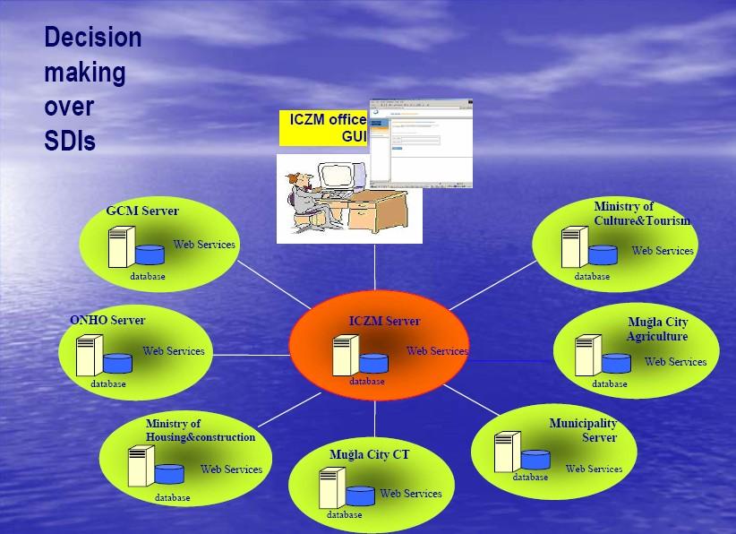
10 Background Generating a zoning plan from via Web services Municipality ZPO GUI CO Server Web Services getparcelgeometry CO Database ZPO Server ZPO Database Web Services getparcelzoningpl an getzoningplanid getzoningplanbloc k vectorsuperimpos e getzoningplanbloc kattrib LTO Server Web Services getparcelattribute LTO Database

11 Background Generating a zoning plan from via Web services SVG toolbox
12 Background Developing A Service Oriented Analysis And Design Methodology In The Example Of Cadastral Web Services Hasan Tahsin Bostancı Ph.D.Thesis, 2010 Land title and Cadastre Services Generate Applicatio n Plan Generate PlanExamp le GenerateP lan Generate Technical Document General Services GetParcel Corner Coordinat es GetParcel Geometry Calculat e ParcelSi de External Developers Prepare ZoningStatus Generate Plan Change Calculate ParcelAre a GetBlock Number GetParcel Number GetPlot Number Atomic Services Calculate PropertyTax Prepare BuildingPermi t Composed Services
13 Aim of Study We try to find out Can spatial processes be executed without using any GIS (Geographic Information System)? Can spatial web services be developed with Free and Open Source Software (FOSS)
14 CASE STUDY Why choose FOSS? Source code is open For time and financial efficiency
15 Application Plan
16 Steps Determine the needed web services, Determine the FOSS that will be used to develop web services, Deploy and run the web services on the web application server
17 The needed web services * Hasan Tahsin Bostancı Ph.D.Thesis, 2010 Web Service Explanation Input Output GetParcelGeometry Returns the geometry of parcel (boundaries). Parcel_ID Parcel Geometry CalculateParcelArea Returns the calculated area Parcel_ID Calculated area of parcel GetBuildingGeometry Returns the geometry of building/buildings if necessary (boundaries) Parcel_ID Building Geometry GetParcelCornerCoordinat es Returns the corner coordinates of parcel Parcel_ID Corner coordinates of parcel GetBuildingCornerCoordi nates Return the corner coordinates of the parcel if there are building/buildings on the parcel Parcel_ID Corner coordinates of building CalculateParcelSide Calculate the side lengths of the parcel Parcel_ID Lengths of parcel side GetPolygonCoordinates Returns the coordinates of polygons which are inside the buffer area as a result of buffer analysis to the parcel Parcel_ID Polygons and polygon coordinates DrawNeighbourParcelBor der Returns the border of neighbor parcels which are inside the buffer area as a result of buffer analysis to the parcel Parcel_ID Neighbor parcel boundaries
18 Search for getparcelgeometry routine in FOSS
19 Determining the FOSS That Will Be Used To Develop Web Services Pre-Selection:» Literature Review» Research related projects» Web search over avaliable FOSS Final Selection» Generate criteria


20 Literature Review Hall and Leahy, 2008 MapGuide No criteria to select a suitable FOSS
21 Ramsey, 2007 Criteria: Desktop FOSS software Programming language used in coding the Whether the software is an application or library Web Projects Toolkits Frameworks Servers There are over thirty software

22 Steiniger, 2008 Criteria:»»»»»» Application Focus User Level Supported operating system Development platform Developed by Software license Kosmo ILWIS
23 Related projects GeOnAs (GeoBrain Online Analysis System) GRASS Based Web Services Vector and raster analysis User interface of GeOnAs
24 AWARE (A tool for monitoring and forecasting available water resource in mountain environments) Spatial web services in hydrology Sextante, GeoTools, JFreeChart integrated on 52NWPS
25 Major Web Sites listing Geospatial Open Source Software only Major Web Sites listing General Open Source Software


26 WHICH SOFTWARE?
27 Final Selection: Functional content: How comprehensive is the FOSS? Does the FOSS contain specific routines (e.g. getparcelgeometry)? Operating System (OS): Is the FOSS compatible with the required OS which is Windows XP in our case. Code Maturity: Is the code mature enough? Less `bugs` in the source code. Licence: LGPL. Programming Language: Java.

28 Software Researched in Scope of Case Study Sextante A set of free geospatial analysis tools * ü Java based geospatial routine library. ü Very high Functional content ; offers many routines for raster and vector data. ü Windows 32 systems compatible.! Code maturity * problems. ü Sextante Toolbox
29 Test for clip routine of Sextante Why? clip routine in Sextante could be used for the function of getbuildinggeometry web service. We integrate Sextante to gvsig and try clip routine both in Sextante and gvsig.


30 Parcel and building layers 1. Region 2. Region

 gvsig")

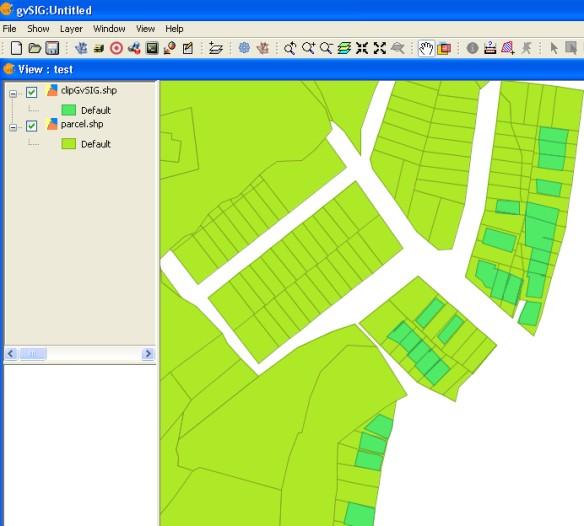
31 Results of clip routine Sextante clip result (1. region) gvsig clip result (1. region) Sextante clip result (2. region) gvsig clip result (2. region)
32 GeOnAs GRASS Based Web Services Geospatial web services in GeOnAs project are developed using GRASS functions ü Programming language, axis web services! Web services are only compatible with LINUX OS. ü GeOnAs online web services user interfac

33 Extentions ü ü ü ü ü GeoTools is an open source library that provides tools for geospatial data *. Java It is built up on robust libraries like JTS and GeoAPI, it has classes to make general analysis, not much specific routines as in Sextante. LGPL licence. Windows XP compatible. It is more code mature than Sextante. *

34 The final selection result GeoTools is the only one that satisfies the criteria.
35 Deploy and run the web services on the web application server Software used o o o o o J2SDK (Java Software Development Kit) GeoTools is Java based library. GeoTools Eclipse as Java IDE Apache Maven - GeoTools recommends. WSO2 Web Services Application Server (WSAS) to deploy web services.

36 Eclipse Java IDE user interface

37 WSAS User Interface
38 Advantages and disadvantages of FOSS, Advantages ü ü ü Our findings Disadvantages Being usually free of charge, otherwise available for a small fee ü ü Having active discussion forums for users and developers No implementation warranty Published before being checked thoroughly enough for bugs; For instance, although clip routine in Sextante does not give correct results, it is published. Being Open Source ü Insufficient documentation; GeoTools is a geospatial FOSS library which is often updated. The manuals are neither sufficient nor up-todate.
39 Conclusion and Suggestion We find GeoTools library to be the most suitable geospatial software to be used in developing web services. GeoTools library is the only FOSS among the ones we researched that satisfies the criteria we determined. The part of the work with the most difficulties has been to see whether a web service routine is already implemented in any existing FOSS. Currently, we have to carefully examine all the source codes or research many manuals. Given the huge number of FOSS available, this is a highly impractical solution to the problem. Additionally, to make better use of FOSS being open source, there should be a syntactic or semantic search facility for routines.
40 Questions?
Introduction to INSPIRE. Network Services
 Introduction to INSPIRE. Network Services European Commission Joint Research Centre Institute for Environment and Sustainability Digital Earth and Reference Data Unit www.jrc.ec.europa.eu Serving society
SEXTANTE, a free platform for geospatial analysis
 SEXTANTE, a free platform for geospatial analysis Olaya, Victor May 20, 2009 1 Introduction The SEXTANTE project 1 aims to create a platform for the development of geoalgorithms that makes it easy both
Compass INSPIRE Services. Compass INSPIRE Services. White Paper Compass Informatics Limited Block 8, Blackrock Business
 Compass INSPIRE Services White Paper 2010 Compass INSPIRE Services Compass Informatics Limited Block 8, Blackrock Business Park, Carysfort Avenue, Blackrock, County Dublin, Ireland Contact Us: +353 1 2104580
Sub-national dimensions of INSPIRE
 www.eurogeographics.org CONNECTING YOU TO THE Sub-national dimensions of INSPIRE SDIs in the evolving EU society Dave Lovell, Secretary General and Executive Director 24 June 2013 Copyright 2013 EuroGeographics
SEXTANT 1. Purpose of the Application
 SEXTANT 1. Purpose of the Application Sextant has been used in the domains of Earth Observation and Environment by presenting its browsing and visualization capabilities using a number of link geospatial
Introduction to Autodesk MapGuide EnterpriseChapter1:
 Chapter 1 Introduction to Autodesk MapGuide EnterpriseChapter1: In this chapter, you review the high-level key components that comprise Autodesk MapGuide Enterprise. The Autodesk MapGuide Studio, an integral
Introduction to Autodesk MapGuide EnterpriseChapter1:
 Chapter 1 Introduction to Autodesk MapGuide EnterpriseChapter1: In this chapter, you review the high-level key components that make up Autodesk MapGuide Enterprise. The Autodesk MapGuide Studio, an integral
A Spatial Decision Support System Design for Land Consolidation Projects
 A Spatial Decision Support System Design for Land Consolidation Projects Tayfun CAY, Mevlut UYAN Selcuk University, Konya (TURKEY) 1 1. INTRODUCTION Land consolidation can be described as rearranging and
City of La Crosse Online Mapping Website Help Document
 City of La Crosse Online Mapping Website Help Document This document was created to assist in using the new City of La Crosse online mapping sites. When the website is first opened, a map showing the City
OPEN SOURCE SOLUTIONS FOR SURVEYORS
 2 nd Sabah International Surveyors Congress 11 th 12 th March 2014 OPEN SOURCE SOLUTIONS FOR SURVEYORS Presented By : Sr Alexander Chong Director, Jurukur Antarabangsa The Benefits Of Closed Proprietary
Open Source Software Solutions
 Open Source Software Solutions Ned Horning horning@amnh.org http://biodiversityinformatics.amnh.org 1 Overview Introduction to open source software Geospatial software options Open Source Geospatial Foundation
European Location Framework (ELF) acting as a facilitator implementing INSPIRE
 acting as a facilitator implementing INSPIRE") www.eurogeographics.org European Location Framework (ELF) acting as a facilitator implementing INSPIRE Saulius Urbanas, Mick Cory (EuroGeographics) 29 October 2016 Copyright 2013 EuroGeographics EuroGeographics
www.eurogeographics.org European Location Framework (ELF) acting as a facilitator implementing INSPIRE Saulius Urbanas, Mick Cory (EuroGeographics) 29 October 2016 Copyright 2013 EuroGeographics EuroGeographics
Ministry of Sustainable Resource Management. Data Sales Panel. Presentation to URISA BC Chapter Richmond, 2002
 Ministry of Sustainable Resource Management Data Sales Panel Presentation to URISA BC Chapter Richmond, 2002 Evert Kenk Business and Information Services Division MSRM Who we are. Agenda Data, Data and
Announcements. Data Sources a list of data files and their sources, an example of what I am looking for:
 Data Announcements Data Sources a list of data files and their sources, an example of what I am looking for: Source Map of Bangor MEGIS NG911 road file for Bangor MEGIS Tax maps for Bangor City Hall, may
Singapore. Mr Soh Kheng Peng. Singapore Land Authority
 Country Report 2006 (Based on the PCGIAP-Data Integration Template 2006) Singapore Country/state: Name of contact person: Affiliation, Organization: Function, Position: Address: Email address: Tel, Fax
INSPIRE in a nutshell, and overview of the European Union Location Framework
 INSPIRE in a nutshell, and overview of the European Union Location Framework Francesco Pignatelli European Commission, DG JRC 10 th European Congress and Exhibition on Intelligent Transport Systems and
3D Cadastral System Functionalities for 5D Multi- Purpose LIS
 3D Cadastral System Functionalities for 5D Multi- Purpose LIS ΕΣΠΑ 2007-2013, Δράση«Διμερής Ε&Τ Συνεργασία Ελλάδας- Ισραήλ 2013-2015» YΠOYPΓEIO ΠAΙΔΕΙΑΣ ΚΑΙ ΘΡΗΣΚΕΥΜΑΤΩΝ Γ.Γ.Ε.Τ. ΕΥΔΕ - ΕΤΑΚ Outline 5DMuPLIS
INSPIRE & Environment Data in the EU
 INSPIRE & Environment Data in the EU Andrea Perego Research Data infrastructures for Environmental related Societal Challenges Workshop @ pre-rda P6 Workshops, Paris 22 September 2015 INSPIRE in a nutshell
This guide will tell you all you need to know about the new Front Desk application which can be found on the main Peoria County GIS website.
 New Front Desk Quick Guide, 2014 At a First Glance This guide will tell you all you need to know about the new Front Desk application which can be found on the main Peoria County GIS website. When you
Module 10 Data-action models
 Introduction Geo-Information Science Practical Manual Module 10 Data-action models 10. INTRODUCTION 10-1 DESIGNING A DATA-ACTION MODEL 10-2 REPETITION EXERCISES 10-6 10. Introduction Until now you have
ENGRG Introduction to GIS
 ENGRG 59910 Introduction to GIS Michael Piasecki April 3, 2014 Lecture 11: Raster Analysis GIS Related? 4/3/2014 ENGRG 59910 Intro to GIS 2 1 Why we use Raster GIS In our previous discussion of data models,
Introduction to Geodatabase and Spatial Management in ArcGIS. Craig Gillgrass Esri
 Introduction to Geodatabase and Spatial Management in ArcGIS Craig Gillgrass Esri Session Path The Geodatabase - What is it? - Why use it? - What types are there? - What can I do with it? Query Layers
Using AutoCAD Map 3D to Solve Real World Issues
 Using AutoCAD Map 3D to Solve Real World Issues Written by: Steve Skarbowski, Synergis Engineering Design Solutions Geospatial Solutions Engineer Let us imagine that we have a tank farm located in a highly
Introduction to QGIS
 Introduction to QGIS David Kramar, Ph.D. Minnesota State University Moorhead Department of Anthropology and Earth Science http://www.qgis.org/en/site/ Overview of Workshop What is QGIS? How do I get QGIS
Developing a Free and Open Source Software based Spatial Data Infrastructure. Jeroen Ticheler
 Developing a Free and Open Source Software based Spatial Data Infrastructure Jeroen Ticheler 1 License This work is licensed under the Creative Commons Attribution-NonCommercial-ShareAlike 2.5 License.
Interactive Maps Purpose: Login to the System: Interactive Maps ONTINUE AGREE
 Interactive Maps Purpose: The purpose of this application is to provide the facility to the citizen to navigate to a Property through an On-line Free Web Application in real time. The application uses
Guide: Entering an Application for an Existing Groundwater Licence. in Virtual FrontCounter BC
 Guide: Entering an Application for an Existing Groundwater Licence in Virtual FrontCounter BC February 2017 1 PURPOSE OF THIS GUIDE... 4 Getting to the Application... 4 Step 1 Start the application...
INSPIRE overview and possible applications for IED and E-PRTR e- Reporting Alexander Kotsev
 INSPIRE overview and possible applications for IED and E-PRTR e- Reporting Alexander Kotsev www.jrc.ec.europa.eu Serving society Stimulating innovation Supporting legislation The European data puzzle 24
Aim of the presentation
 G e n e r ic G I S f o r e -G o v e r n m e n t 0 8 /0 2 /0 7 Aim of the presentation Why it s so difficult to open geographic data and how can gegis solve this p. 2 Availability Distribution of data by
Rainforest Alliance. Spatial data requirements and guidance. June 2018 Version 1.1
 Rainforest Alliance Spatial data requirements and guidance June 2018 Version 1.1 More information? For more information about the Rainforest Alliance, visit www.rainforest-alliance.org or contact info@ra.org
INCREASING CLASSIFICATION QUALITY BY USING FUZZY LOGIC
 JOURNAL OF APPLIED ENGINEERING SCIENCES VOL. 1(14), issue 4_2011 ISSN 2247-3769 ISSN-L 2247-3769 (Print) / e-issn:2284-7197 INCREASING CLASSIFICATION QUALITY BY USING FUZZY LOGIC DROJ Gabriela, University
Creating a 3D Model for Environmental Noise Simulation at the German Federal Railways Agency. Disy Informationssysteme GmbH
 Creating a 3D Model for Environmental Noise Simulation at the German Federal Railways Agency Disy Informationssysteme GmbH Creating a 3D Model for Noise Simulation at the German Federal Railways Agency
Egyptian Survey Authority Geographic Information Management System (ESA GIM)
") Egyptian Survey Authority Geographic Information Management System (ESA GIM) Sohail El ABD and Kholoud SAAD, Egypt Key words: GIS, theme, etc. SUMMARY ESA can be regarded as the backbone for supplying
Egyptian Survey Authority Geographic Information Management System (ESA GIM) Sohail El ABD and Kholoud SAAD, Egypt Key words: GIS, theme, etc. SUMMARY ESA can be regarded as the backbone for supplying
A New Approach for Data Conversion from CAD to GIS
 Esin Bitik (PhD) Dursun Zafer Şeker Ziyadin ÇAKIR Hakan DENLİ A New Approach for Data Conversion from CAD to GIS June 19, 2014 Contents 1. Aim of the study 2. Introduction 3. Vector Data Structure 4. Converting
Benefits from INSPIRE: Groundwater information management. Carla Nikkels Manager GIS applications, Bij12/GBO-P
 Benefits from INSPIRE: Groundwater information management Carla Nikkels Manager GIS applications, Bij12/GBO-P About Bij12 (@12) : a Shared service for 12 NL Provinces Information managment of 19 shared
GIS in agriculture scale farm level - used in agricultural applications - managing crop yields, monitoring crop rotation techniques, and estimate
 Types of Input GIS in agriculture scale farm level - used in agricultural applications - managing crop yields, monitoring crop rotation techniques, and estimate soil loss from individual farms or agricultural
An Open Source Software approach to Spatial Data Infraestructures.
 Second Part INSPIRE and SDI: heterogeneous GI accessing solution An Open Source Software approach to Spatial Data Infraestructures. Study of different scenarios Second Part: INDEX I. Intro: SDI: Beginings,
EWRG-CES. Bharath Setturu EWRG, CES, IISc
 Bharath Setturu EWRG, CES, IISc What is Free and Open Source? Free and Open source describes a broad general type of free software license that makes source code available to the general public with no
InCLUDE Data Exchange. Julia Harrell, GISP GIS Coordinator, NC DENR
 InCLUDE Data Exchange Julia Harrell, GISP GIS Coordinator, NC DENR Julia.harrell@ncdenr.gov InCLUDE Project Partners NC Department of Environment & Natural Resources: The State of NC s lead environmental
The European Location Framework (ELF) Project One Source for Reference Geo Information for Europe
 Project One Source for Reference Geo Information for Europe") The European Location Framework (ELF) Project One Source for Reference Geo Information for Europe Presentation to: By: Date: ICC Dresden Antti Jakobsson, Technical Coordinator 28 th August 2013 The ELF
The European Location Framework (ELF) Project One Source for Reference Geo Information for Europe Presentation to: By: Date: ICC Dresden Antti Jakobsson, Technical Coordinator 28 th August 2013 The ELF
Development of Java Plug-In for Geoserver to Read GeoRaster Data. 1. Baskar Dhanapal CoreLogic Global Services Private Limited, Bangalore
 Development of Java Plug-In for Geoserver to Read GeoRaster Data 1. Baskar Dhanapal CoreLogic Global Services Private Limited, Bangalore 2. Bruce Thelen CoreLogic Spatial Solutions, Austin, USA 3. Perumal
FAQ & Troubleshooting
 FAQ & Troubleshooting What is the most common issue users have when using the site? Pop-Up Blocker!!! Any link external to the viewer requires a new window to be opened in the browser. See My map or report
Model Design and Evaluation
 Model Design and Evaluation The General Modeling Process YES Define Goals Compartments Systematize Add Spatial Dimension Complete? NO Formulate & Flowchart Return Return NO Complete? Deliver Implement
Public Private Partnership based on the NSDI of Spain: Regulation and examples from the National Geographic Institute. Título. Sebastián Mas-Mayoral
 1 Public Private Partnership based on the NSDI of Spain: Regulation and examples from the National Geographic Institute. Título Sebastián Mas-Mayoral 2 PPP in Spain Public private partnership is usually
Remote Sensing and GIS. GIS Spatial Overlay Analysis
 Subject Paper No and Title Module No and Title Module Tag Geology Remote Sensing and GIS GIS Spatial Overlay Analysis RS & GIS XXXI Principal Investigator Co-Principal Investigator Co-Principal Investigator
Spatial data and QGIS
 Spatial data and QGIS Xue Jingbo IT Center 2017.08.07 A GIS consists of: Spatial Data. Computer Hardware. Computer Software. Longitude Latitude Disease Date 26.870436-31.909519 Mumps 13/12/2008 26.868682-31.909259
Cuyahoga County Addressing Notification System Cuyahoga County Department of Information Technology
 Page(s) 1 of 10 Administrative Standard Operating Procedure Cuyahoga County Addressing Notification System Cuyahoga County Department of Information Technology Document Revision History Date of Revision
Making Topographic Maps
 T O P O Applications N Making Topographic Maps M A P S Making Topographic Maps with TNTmips page 1 Before Getting Started TNTmips provides a variety of tools for working with map data and making topographic
Lab 1: Exploring ArcMap and ArcCatalog In this lab, you will explore the ArcGIS applications ArcCatalog and ArcMap. You will learn how to use
 Lab 1: Exploring ArcMap and ArcCatalog In this lab, you will explore the ArcGIS applications ArcCatalog and ArcMap. You will learn how to use ArcCatalog to find maps and data and how to display maps in
County of Los Angeles. Chief Information Office Preferred Technologies for Geographic Information Systems (GIS) Version 2 May 2015
 Version 2 May 2015") County of Los Angeles Chief Information Office Preferred Technologies for Geographic Information Systems (GIS) Version 2 May 2015 CIO Preferred Technologies for GIS This document lists the preferred Geographic
County of Los Angeles Chief Information Office Preferred Technologies for Geographic Information Systems (GIS) Version 2 May 2015 CIO Preferred Technologies for GIS This document lists the preferred Geographic
Chapter 17 Creating a New Suit from Old Cloth: Manipulating Vector Mode Cartographic Data
 Chapter 17 Creating a New Suit from Old Cloth: Manipulating Vector Mode Cartographic Data Imagine for a moment that digital cartographic databases were a perfect analog of the paper map. Once you digitized
Computational Geometry Algorithms Library. Geographic information Systems
 Computational Geometry Algorithms Library in Geographic information Systems Edward Verbree, Peter van Oosterom and Wilko Quak TU Delft, Department of Geodesy, Thijsseweg 11, 2629 JA Delft, the Netherlands
SDI and the Key Elements
 SDI and the Key Elements Roger Longhorn Information Policy Advisor, The Coastal & Marine Union (EUCC) Senior Information Policy Analyst & Principal SDI Expert, Compass Informatics Ltd (Ireland) (www.compass.ie)
Town of Amherst, NY. GIS Map Machine User Guide. Map Window Search Functions. Help. Toolbar. Layer Control. Scale Bar
 Town of Amherst, NY GIS Map Machine User Guide Toolbar Map Window Search Functions Help Layer Control Scale Bar Map Window Main Elements The MAP WINDOW is the main focus of the screen and where the map
Module 7 Raster operations
 Introduction Geo-Information Science Practical Manual Module 7 Raster operations 7. INTRODUCTION 7-1 LOCAL OPERATIONS 7-2 Mathematical functions and operators 7-5 Raster overlay 7-7 FOCAL OPERATIONS 7-8
Challenges that can be overcome with the aid of ESA GIM Click to edit Master text styles
 Click to edit Agenda Master By: Egyptian Survey Authority Geographic Information Management System Kholoud Saad Salama Egypt (ESA GIM) 1 About Egyptian Survey Authority Third ESA GIM level Business Requirements
Spatial Technologies Assessing Rural Septic Systems STARSS
 Spatial Technologies Assessing Rural Septic Systems STARSS Southern Region Extension Water Quality Conference October 20-21, 21, 2003 Chuck O Hara cgohara@gri. @GRI.MSState.Edu Acknoledgements Funded by
VISUALIZATION PRINCIPLES IN 3D CADASTRE: A FIRST ASSESSMENT OF VISUAL VARIABLES
 VISUALIZATION PRINCIPLES IN 3D CADASTRE: A FIRST ASSESSMENT OF VISUAL VARIABLES Ph.D. Candidate Chen Wang Dr. Jacynthe Pouliot Dr. Frédéric Hubert Department of Geomatics, Laval University, Quebec, Canada
GVSIG EDUCA. Technical implementation report
 GVSIG EDUCA Technical implementation report ASSOCIATION FOR THE PROMOTION OF FOSS4G AND THE DEVELOPMENT OF gvsig Contact Info: info@gvsig.com 2012 gvsig October 2012 Page 2 of 9 Index of contents 1 INTRODUCTION...4
Welcome to NR402 GIS Applications in Natural Resources. This course consists of 9 lessons, including Power point presentations, demonstrations,
 Welcome to NR402 GIS Applications in Natural Resources. This course consists of 9 lessons, including Power point presentations, demonstrations, readings, and hands on GIS lab exercises. Following the last
Oracle Spatial Technologies: An Update. Xavier Lopez Director, Spatial Technologies Oracle Corporation
 Oracle Spatial Technologies: An Update Xavier Lopez Director, Spatial Technologies Oracle Corporation Overview Oracle Approach to Market Specialist v. Generalist Solutions New Developments: Oracle Database
InCLUDE Data Exchange. Julia Harrell, GISP GIS Coordinator, NC DENR
 InCLUDE Data Exchange Julia Harrell, GISP GIS Coordinator, NC DENR Julia.harrell@ncdenr.gov InCLUDE Project Partners NC Department of Environment & Natural Resources: The State of NC s lead environmental
Enterprise GIS for Managing Reservation Land
 Enterprise GIS for Managing Reservation Land Beckie Howell GIS Manager Agua Caliente Band of Cahuilla Indians ESRI UC 2014 Tribal Indigenous GIS Track Empowering Tribal Governments with Enterprise GIS
Creating a Smaller Data Set from a Larger Data Set Vector Data
 Creating a Smaller Data Set from a Larger Data Set Vector Data Written by Barbara Parmenter, revised by Carolyn Talmadge January 16, 2015 USING THE SELECTION METHOD QUICK METHOD BY CREATING A LAYER FILE...
Technology for Cadastral Applications. John R. Hacker, Jr. Marketing Manager Geospatial Applications
 Technology for Cadastral Applications John R. Hacker, Jr. Marketing Manager Geospatial Applications Agenda Cadastral Mapping Issues Precision and Accuracy Data Creation Data Management Data Publishing
The role of free software thick clients in SDI: Case of gvsig
 The role of free software thick clients in SDI: Case of gvsig Michael Gould, Carlos Granell, Miguel Angel Esbrí -- Univ Jaume I, Castellón, Spain Gabriel Carrión -- Generalitat Valenciana Take-home messages
SPATIOTEMPORAL INDEXING MECHANISM BASED ON SNAPSHOT-INCREMENT
 SPATIOTEMPORAL INDEXING MECHANISM BASED ON SNAPSHOT-INCREMENT L. Lin a, Y. Z. Cai a, b, Z. Xu a a School of Resource and Environment Science,Wuhan university, Wuhan China 430079, lilin@telecarto.com b
Esri Best Practices: QA/QC For Your Geodata. Michelle Johnson & Chandan Banerjee
 Esri Best Practices: QA/QC For Your Geodata Michelle Johnson & Chandan Banerjee Overview Understand Document Implement Understanding QA/QC Understanding QA/QC Fit For Use - support your GIS applications?
Lessons Learned from Implementing an Enterprise GIS solution for Cross-Country Pipeline Routing
 Lessons Learned from Implementing an Enterprise GIS solution for Cross-Country Pipeline Routing Jackie Smith, Williams Wetherbee Dorshow, Earth Analytic, Inc April 27, 2016 2013 The Williams Companies,
GRASS. Geographic Resources Analysis Support System Current versions. Related software
 GRASS Geographic Resources Analysis Support System http://grass.osgeo.org Current versions 6.3 stable (old) 6.4 next stable (new) 7 development (future) Related software QGIS http://qgis.org GRASS Capabilities
Peoria County Front Desk Map Application
 Peoria County Front Desk Map Application Quick Guide, 2017 At a First Glance This guide will tell users all they need to know about the Peoria County Front Desk application which can be found on the Peoria
Basic Geospatial Analysis Techniques: This presentation introduces you to basic geospatial analysis techniques, such as spatial and aspatial
 Basic Geospatial Analysis Techniques: This presentation introduces you to basic geospatial analysis techniques, such as spatial and aspatial selections, buffering and dissolving, overly operations, table
SAP HANA Spatial Location-based business platform
 SAP HANA Spatial Location-based business platform Thomas Hammer, HANA Spatial Development April 19, 2018 SAP HANA Architecture Application development All Devices SAP, ISV and Custom Applications SAP HANA
GNC on Demand. Final Report. Developers: Andres Westermann Christoph Mülligann
 GNC on Demand Final Report Developers: Andres Westermann Christoph Mülligann Damian Lasnia Jafar Hafiz
ASSET AND OPERATIONS MANAGEMENT INTEGRATED SOLUTIONS FOR EFFECTIVE LOW COST MONITORING. Colin Davies. Carbon Based Environmental Pty Ltd
 ASSET AND OPERATIONS MANAGEMENT INTEGRATED SOLUTIONS FOR EFFECTIVE LOW COST MONITORING Paper Presented by: Colin Davies Author: Colin Davies, Managing Director, Carbon Based Environmental Pty Ltd 6 th
What s s Coming in ArcGIS 10 Desktop
 What s s Coming in ArcGIS 10 Desktop Damian Spangrud ArcGIS Product Manager, ESRI dspangrud@esri.com (or at least turn to silent) ArcGIS 10 A Simple & Pervasive System for Using Maps & Geographic Information
pgrouting extends the postgis/postgresql geospatial database to provide geospatial routing and other network analysis functionality.
 Workshop: 1 pgrouting extends the postgis/postgresql geospatial database to provide geospatial routing and other network analysis functionality. Attendee s previous knowledge: SQL (PostgreSQL, PostGIS)
INSPIRE status report
 INSPIRE Team INSPIRE Status report 29/10/2010 Page 1 of 7 INSPIRE status report Table of contents 1 INTRODUCTION... 1 2 INSPIRE STATUS... 2 2.1 BACKGROUND AND RATIONAL... 2 2.2 STAKEHOLDER PARTICIPATION...
Open source technologies and INSPIRE network services in Slovak environmental agency
 Open source technologies and INSPIRE network services in Slovak environmental agency Peter Mozolík, Martin Koška, Marek Žiačik, Martin Tuchyňa Slovak Environmental Agency (SEA) SEA role within slovak SDI
GIS and Forest Engineering Applications
 FE 257. GIS and Forest Engineering Applications Week 3 This week s topics Clip and erase processes Chapter 6 Selecting landscape features in a GIS Chapter 5 GIS Lab3: Determining land use and ownership
Contents USER S MANUAL 1
 USER S MANUAL IRENA 2016 This manual was prepared by the International Renewable Energy Agency (IRENA) to provide comprehensive, step-by-step guidance to users of the web-based Sustainable Energy Marketplace
GISCI GEOSPATIAL CORE TECHNICAL KNOWLEDGE EXAM CANDIDATE MANUAL AUGUST 2017
 GISCI GEOSPATIAL CORE TECHNICAL KNOWLEDGE EXAM CANDIDATE MANUAL AUGUST 2017 This document provides information about the GISCI Geospatial Core Technical Knowledge Exam, now a requirement for GISCI GISP
ArcGIS 10.1 for Desktop Artie Robinson
 ArcGIS 10.1 for Desktop Artie Robinson ArcGIS A Complete System for Geographic Information Cloud Web Online Mobile Enterprise Desktop Name Change Name Prior to 10.1 ArcGIS Desktop ArcInfo ArcEditor ArcView
Measure the Perimeter of Polygons Over a Surface. Operations. What Do I Need?
 Measure the Perimeter of Polygons Over a Surface Operations What Do I Need? Incremental Frontage Score To measure the perimeter of polygons over a surface you need to have two input map layers. The first
Geological mapping using open
 Geological mapping using open source QGIS MOHSEN ALSHAGHDARI -2017- Abstract Geological mapping is very important to display your field work in a map for geologist and others, many geologists face problems
DISASTER RISK MANAGEMENT INFORMATION SYSTEMS IN TAIWAN. Dean, College of Planning and Design National Cheng Kung University Taiwan
 DISASTER RISK MANAGEMENT INFORMATION SYSTEMS IN TAIWAN Prof. Feng-Tyan LIN Dean, College of Planning and Design National Cheng Kung University Taiwan Taiwan has been implementing National GIS Projects
QGIS Tutorials Documentation
 QGIS Tutorials Documentation Release 0.1 Nathaniel Roth November 30, 2016 Contents 1 Installation 3 1.1 Basic Installation............................................. 3 1.2 Advanced Installation..........................................
Marine and Coastal Data Services in the Cloud. Richard Rombouts - Snowflake Software Ltd. & Keiran Millard SeaZone Solutions Ltd.
 Marine and Coastal Data Services in the Cloud Richard Rombouts - Snowflake Software Ltd. & Keiran Millard SeaZone Solutions Ltd. Marine Geospatial Data Inspired Marine Data? SeaZone HydroSpatial Global
OS OpenData masterclass 2013 Cartographic Design workshop
 OS OpenData masterclass 2013 Cartographic Design workshop 1 Quantum GIS Quantum GIS (QGIS) is a user-friendly Open Source Geographic Information System (GIS,) licensed under the GNU General Public License.
Data quality from a producer s perspective. Dolors Barrot & Maria Pla
 Data quality from a producer s perspective Dolors Barrot & Maria Pla Dolors.barrot@icgc.cat Maria.pla@icgc.cat 2 Contents Context Quality information Collected data Examples Management 3 Context Institut
Beyond PostGIS. New developments in Open Source Spatial Databases. Karsten Vennemann. Seattle
 New developments in Open Source Spatial Databases Karsten Vennemann Seattle Talk Overview Intro Relational Databases PostGIS JASPA INGRES Geospatial MySQL Spatial Support HatBox a user space extension
Data Assembling Topics:
 Topics: 1. GPX to Shape file 2. Data conversion with FME 3. Create a polygon feature 4. Merging /Appending data into a new dataset 5. Reproject data from one coordinate system to another 6. Data clipping
Facilities Management Data Input, Editing and Management. Adrien Litton
 Facilities Management Data Input, Editing and Management Adrien Litton Overview What is FM in GIS? Data input Data editing Data management Supporting the Real Property Life-Cycle GIS Integrates the Facility
REDI 5.0 User Manual
 REDI 5.0 User Manual OBJECTIVE: REDI (Regional Economic Development Information System) provides a quick, convenient and easy way of accessing the City of San Diego Business Incentive Zones (BIZ) information.
AN ITERATIVE PROCESS FOR MATCHING NETWORK DATA SETS WITH DIFFERENT LEVEL OF DETAIL
 AN ITERATIVE PROCESS FOR MATCHING NETWORK DATA SETS WITH DIFFERENT LEVEL OF DETAIL Yoonsik Bang, Chillo Ga and Kiyun Yu * Dept. of Civil and Environmental Engineering, Seoul National University, 599 Gwanak-ro,
GIS Basics for Urban Studies
 GIS Basics for Urban Studies Date: March 21, 2018 Contacts: Mehdi Aminipouri, Graduate Peer GIS Faciliator, SFU Library (maminipo@sfu.ca) Keshav Mukunda, GIS & Map Librarian Librarian for Geography (kmukunda@sfu.ca)
INSPIRE Web Services for Maritime Affairs in Germany
 INSPIRE Web Services for Maritime Affairs in Germany Matthias Pramme www.bsh.de 1 Agenda Introduction to BSH Relevant INSPIRE Themes Implementation Water Transport Networks Problems and Difficulties Future
GEOGRAPHIC INFORMATION SYSTEMS Lecture 02: Feature Types and Data Models
 GEOGRAPHIC INFORMATION SYSTEMS Lecture 02: Feature Types and Data Models Feature Types and Data Models How Does a GIS Work? - a GIS operates on the premise that all of the features in the real world can
Berlin 3 December Aarhus Convention: Key trends in the implementation of information pillar
 Berlin 3 December 2018 Aarhus Convention: Key trends in the implementation of information pillar Is this moorland in good enough condition to effectively capture rain and prevent flooding? What would the
A CONSISTENCY MAINTENANCE OF SHARED BOUNDARY AFTER POLYGON GENERALIZATION
 CO-182 A CONSISTENCY MAINTENANCE OF SHARED BOUNDARY AFTER POLYGON GENERALIZATION AI T.(1), ZHANG W.(2) (1) Wuhan University, WUHAN CITY, CHINA ; (2) Zhongnan University of Economics and Law, WUHAN CITY,