S-100 Product Specification Roll Out Implementation Plan. Introduction
|
|
|
- Lesley Simmons
- 5 years ago
- Views:
Transcription
1 S-100 Product Specification Roll Out Implementation Plan Introduction This intent of this plan is to provide status, challenges, timelines, and strategies for the suite of S-100 products under development by the IHO. While there are a number of named product specifications, only a subset are currently under active development. The IHO has developed and adopted Technical Resolution 2/2007 as the formal standards development lifecycle, which provides a general guideline that is followed in the standards approval process. Principles of S-100 S-100 provides a contemporary hydrographic geospatial data standard that can support the variety of hydrographic-related digital data sources, products, and customers. Its main features include: Separating the data content from the carrier (file format). In this way, data can be manipulated and encoded without being permanently tied to a single exchange mechanism. Manageable flexibility that can accommodate change. The content of product specifications will be a subset of S-100, including separate feature catalogues. This allows the core standard to evolve (through extension) without the need to introduce new versions of product specifications. Alignment with the series of current geospatial information standards adopted by the International Organization for Standardization (ISO 191xx). This ensures compatibility, or interoperability, with other domains. An I SO-conforming web-based registry containing registers for feature data di cti onari es, portrayal and metadata. The registers accommodate both core hydrographic content and other chart related content and can be extended beyond geospatial data. The registry architecture also contributes to the flexibility of the standard. S-100 specifies, for hydrographic and related information, methods and tools for data management, processing, analyzing, accessing, presenting and transferring such data in digital/electronic form between different users, systems and locations. By following, this set of standards users will be able to build constituent parts of an S-100 compliant product specification. Most S-100 based product specifications include the following components which provide the structure to define and portray real-world features for a wide variety of maritime and geospatial applications.
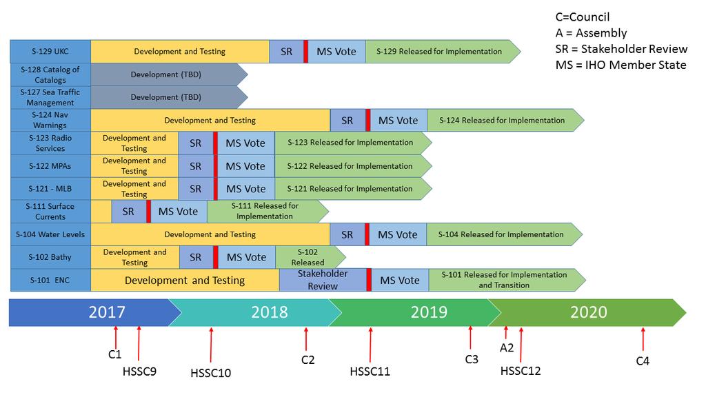
2 Main Feature Catalogue Specifies what is needed to build a complete product Feature types Geometry Data formats and file size Metadata Features Attributes Enumerants Bindings Point, curve or surface Portrayal Catalogue Symbols, line styles and area fills Rule for how the feature attribute combination must be portrayed Data Classification and Encoding Guide Guidance on how the data should be encoded by the data producer Useful as a template for building the feature catalogue Exchange Format Data format that is used for data exchange ISO 8211 normally used for ECDIS GML good for exchanging information outside of the ECDIS arena HDF used for coverage based product specifications Figure 1- Components of an S-100 Product Specification Overarching Request: NOAA was able to contract two experts for four months to help progress some of the underlying tasks that needed resourcing to be progressed. This has been a great help in providing updated data models for various specifications and completing the initial draft of the S-100 interoperability specification that was originally started using NOAA/ROK grant funds. The funding used for this has run out, so there is currently no way to extend contract resources. In order to continue progress, a reliable, uninterrupted funding stream is necessary. Consolidated Timeline: The following graphic shows the array of various IHO product specifications under development and a general target when they may come up for vote by the IHO MS.
3
4 S-101 The new Electronic Navigational Chart Specification S100WG HSSC 11 (2019) 3 rd Quarter th Quarter 2019 S-101 represents the evolution of S-57 based ENCs by taking advantage of the flexibility of the IHO GI Registry. The changes introduced by S-101 will be transparent to the encoders of ENCs. The largest percentage of features and attributes remain unchanged, but there will be a need to change the techniques used where information types and complex attributes are introduced. In addition, S-101 introduces the concept of a cartographic text feature, where parameters stored within hydrographic office production systems can be directly passed to the dataset and then displayed on the navigation system in a similar manner as the paper chart. Current Challenges: The biggest delay to the development of S-101 is the need to stabilize the infrastructure that is required to develop S-101 machine-readable catalogues. The Feature Catalogue Builder has been stabilized and the S100WG is working to operationalize and stabilize the portrayal catalogue builder. Challenge Mitigation: The S100WG Chair is the Project Team Lead for S-101 and is unable to devote time (as the chair is focused on S-100 infrastructure) to progressing this further. It is recommended that the IHO find another volunteer who can focus effort on S-101 (either through the interagency delegation or another Member State). The ideal candidate is someone that has excellent project management skills and has the support of their management to devote time to progressing this over the finish line. S-102 Bathymetric Surface Edition S100WG HSSC 10 (2018) 3 rd Quarter th Quarter 2018 Edition of S-102 was initially published in April 2012 as the first product specification to standardize the Bathymetric Surface using the S-100 framework. In the subsequent time, this edition is considered a shakedown edition for implementation and edition is currently in development. The next edition of S-102 will include options for the portrayal of the data on navigation systems, variable resolution grids and improved discovery metadata. Current Challenges: NAVO is working on developing a BAG to S-102 convertor to support interoperability testing. At its completion, the converter will be handed over to the IHO for dissemination to the IHO community. NOAA has not investigated developing a similar convertor for our data. Work needs to be done with software vendors like Esri and Caris to ensure that the new standard is used during database extraction and is part of their COTS tool kit.
5 S-104 Water Level Information for Surface Navigation TWCWG HSSC11 (2019) at the earliest 3 rd Quarter th Quarter 2019 S-104 is meant to be used for the encapsulation, data transfer of tidal and water level data for use within navigation systems (ECDIS), or any proposed dynamic tide and water level prediction application. These have traditionally been supplied as a physical hard copy publication and recently as a separate software installation that may not be integrated with the ECDIS. To improve safety of navigation, this product specification will ensure tidal and water level data supplied by approved authorities for dynamic capability is consistent.. Current Challenges: TWCWG has subject matter expertise in how to calculate water levels; however, they do not have the expertise to develop the S-100 data models. Challenge Mitigation: NOAA offered TWCWG some contract support in the summer of 2017 to help develop the underlying data models for S-104; however, that is only a short-term solution. There needs to be a commitment to include an S-100 expert in the TWCWG to help operationalize forecast systems in ECDIS. S Surface Currents TWCWG HSSC9 or 10 (2017/2018) 4 th Quarter 2017/2 nd Quarter st Quarter 2018/4 th Quarter 2018 S-111 describes how to define and encode surface currents into an S-100 conformant product specification for use within navigation systems. It includes general information for data identification as well as for data content and structure, reference system, data quality aspects, data capture, maintenance, encoding, delivery, metadata and portrayal. Current Challenges: The development of this product specification is progressing; but has been slowed by other related S-100 infrastructure that is needed to support S-100 product specifications. Challenge Mitigation: If the IHO accepts that edition of any product specification is the stabilization edition, then S-111 could be presented to HSSC9 in 2017 for approval. S-111 does not necessarily need a portrayal catalogue for system manufacturers to implement the ability to read and display surface current data. S-111 currently specifies in a textual manner how current data should be displayed, but is lacking the machine-readable catalogue. The first edition is normally where issues are found during the implementation stage and the second edition is used to correct these issues for a wider release.
6 S-121 Maritime Limits and Boundaries S100WG HSSC10 (2018) 3 rd Quarter th Quarter 2018 S-121 describes how to encode and exchange digital maritime boundary information, including maritime limits, zones and boundaries as described under the United Nations Convention on the Law of the Sea (UNCLOS). The specification was developed as part of a request form the UN Division for Oceans and Law of the Sea (DOALOS) that digital datasets submitted for continental shelf submissions should be published in an open source digital standard. The primary purpose of this specification is to support UNCLOS submissions and eventually a secondary purpose could be that the same data could be overlaid in a navigation system to visualize different maritime boundaries that may or may not be a part of the Electronic Navigational Chart. Current Challenges: There have been several leadership changes during the development of this specification as the individual who was leading the effort took another job. This specification has also experienced scope creep with the introduction of new concepts pertaining to land domain management. Challenge Mitigation: HSSC8 in 2016 tasked the project team to stick within the original scope. The project team held a face-to-face meeting in late 2016 to progress the work. It is expected that S-121 will be provided to the HSSC in S-122 Marine Protected Areas NIPWG HSSC10 (2018) 3 rd Quarter th Quarter 2018 S-122 describes how to encode and exchange information on Marine Protected Areas for use in navigation systems. This specification is intended to provide more details about regulations associated with MPA s than is currently found in the Electronic Navigational Chart. In order to progress this work the IHO established a contract with industry experts. It is expected to go before HSSC10 in S-123 Radio Services NIPWG HSSC10 (2018) 3 rd Quarter th Quarter 2018 S-123 for Radio services describes the availability and reliability of radio stations and services offering navigational warnings and weather forecasts. This includes their service areas, services offered and
7 instructions for contacting or using these services. The primary use of this specification is to take information that was published in document form and create a vector overlay that can be used within navigation systems. In order to progress this work the IHO established a contract with industry experts. It is expected to go before HSSC10 in S-124 Navigation Warnings Working Group Target to Council Target to MS Implementation WWNWS Council2 (2018) 4 th Quarter nd Quarter 2019 S-124 is intended to improve the dissemination and integration of navigational warnings within bridge and shore systems via a digital format. This is a unique product specification as it is being developed under the arm of the WWNWS under the IRRC. The primary participant form the United States in this project team is NGA. S-129 Underkeel Clearance Management Working Group Target to Council Target to MS Implementation S100WG Council2 (2018) 4 th Quarter nd Quarter 2019 S-129 will describe the key information outputs of shore based UKCM systems, paying particular attention to: A time based layer indicating calculated (vessel specific) no-go areas, and Critical UKCM waypoints and their associated tidal windows. This project team is making good progress developing the specification which is expected to be completed in 2018.

8 S-100 Interoperability Specification Working Group Target to Council Target to MS Implementation S100WG TBD TBD TBD The S-100 Interoperability Specification is currently under development by the S-100WG and has been funded in a large part by the ROK/NOAA Joint Project Agreement. The aim of this specification is to develop a harmonized methodology for different S-100 based product specifications to display and interact in a harmonized fashion on navigation systems. Figure 2- Bathymetry Overlaying an S-101 ENC without taking interoperability into account Figure 3 - Bathymetry overlaying an S-101 ENC taking interoperability into account. The Land Area is shown displayed on top of the available bathymetry data.
S100WG. State of the Workplan. International Hydrographic Organization Organisation Hydrographique Internationale IHO COUNCIL
 S100WG State of the Workplan IHO COUNCIL State of the Workplan S-100 Edition 4.0.0 S-100 Infrastructure S-100 Product Specification Development Bits and Pieces S-100 Edition 4.0.0 Consideration of 19 proposals
The New Electronic Chart Product Specification S-101: An Overview
 The New Electronic Chart Product Specification S-101: An Overview Julia Powell Marine Chart Division, Office of Coast Survey, NOAA 1315 East West Hwy, Silver Spring, MD 20715 Julia.Powell@noaa.gov 301-713-0388
S-101. The New ENC Product Specification. Julia Powell S-100 Working Group Chair
 S-101 The New ENC Product Specification Julia Powell S-100 Working Group Chair S-101 Major step forward in product specifications for Electronic Navigational Charts Improved Modeling Greater Flexibility
TSMAD: Transfer Standard Maintenance & Applications Development WG Julia Powell Vice Chair
 TSMAD: Transfer Standard Maintenance & Applications Development WG Julia Powell Vice Chair ToR Objectives To maintain, develop and extend: (i) the S-57 IHO transfer standard for digital hydrographic data;
S-100 Test Framework
 S-100WG2-10.5 S-100 Test Framework Delivering the future navigational environment And reflecting the lessons of S-57 ENC/ECDIS Draft Version 0.3 September 2014 Page 1 of 57 1 Introduction The development
KHOA S-100 Testbed Project
 KHOA S-100 Testbed Project S-100WG3-8.1.1 1. General Information Name of testbed: KHOA S-100 Testbed Project Location of testbed: Busan, ROK Time and duration of testbed: Ongoing till S-100 testbed project
S-100 Test Framework
 TSMAS27-4.4.4A S-100 Test Framework Delivering the future navigational environment And reflecting the lessons of S-57 ENC/ECDIS Draft Version 0.2 September 2013 Page 1 of 36 1 Introduction The development
LIST OF ACTIONS&DECISIONS FROM WENDWG-6. ACTIONS&DECISIONS (in bold, action by)
") LIST OF FROM -6 1. Opening and Administrative Arrangements 6/01 Membership Membership 6/02 UK to report to the NSHC Chair on the need for the designation of a new representative at IHB to update the Membership
LIST OF FROM -6 1. Opening and Administrative Arrangements 6/01 Membership Membership 6/02 UK to report to the NSHC Chair on the need for the designation of a new representative at IHB to update the Membership
Next Edition of IHO S-57 (Edition 4): Much more than ENCs
: Much more than ENCs") University of New Hampshire University of New Hampshire Scholars' Repository Center for Coastal and Ocean Mapping Center for Coastal and Ocean Mapping 3-2005 Next Edition of IHO S-57 (Edition 4): Much
University of New Hampshire University of New Hampshire Scholars' Repository Center for Coastal and Ocean Mapping Center for Coastal and Ocean Mapping 3-2005 Next Edition of IHO S-57 (Edition 4): Much
Hydrographic Services and Standards Committee. Dr Vasily Smolyanitsky, JCOMM ETSI chair
 Hydrographic Services and Standards Committee Report of the JCOMM Expert Team on Sea Ice Provision of improved marine weather information in graphical formats: practices for sea ice (SIGRID- 3/ Ice Objects
This paper reports on S-100 Registry improvement and future plans following the request of the 2 nd S-100 WG meeting in Genoa, Italy.
 S-100TSM5-4.3 This paper reports on S-100 Registry improvement and future plans following the request of the 2 nd S-100 WG meeting in Genoa, Italy. Page 2 Page 3 KHOA developed a new interface and database
MASTER PLAN FOR THE DEVELOPMENT AND IMPLEMENTATION OF S-100
 HYDROGRAPHIC SERVICES AND STANDARDS COMMITTEE COMITE DES SERVICES ET DES NORMES HYDROGRAPHIQUES MASTER PLAN FOR THE DEVELOPMENT AND IMPLEMENTATION OF S-100 (Edition 1.1.0 - June 2015) Content 1 Introduction...
S-412 A Weather Overlay Product Specification
 S-412 A Weather Overlay Product Specification LT Joseph Phillips, NOAA Commissioned Corps Technical Operations Coordination Meteorologist National Weather Service - Ocean Prediction Center 5830 University
Paper for Consideration by S100WG TSM. S-57 to S-101 Converter Status
 TSM3-3.5 Paper for Consideration by S100WG TSM S-57 to S-101 Converter Status Submitted by: Esri Executive Summary: This paper summarizes the status of the S-57 to S-101 Converter. Related Documents: S-100,
Development of the S-100 based Ice Information Product
 1 10 th CSPWG MEETING Wellington, New Zealand, 21-24 January, 2014 CSPCWG10-INF4 Development of the S-100 based Ice Information Product Submitted by: Executive Summary: Related Documents: Related Projects:
E-Navigation from the end users perspective
 E-Navigation from the end users perspective Johan Gahnström E-Navigation underway 2017 INTERTANKO Members Lead the continuous improvement of the tanker industry s performance Strive to achieve the goals
Future Edition of IHO S-57 (4.0)1
1") Future Edition of IHO S-57 (4.0)1 By Lee Alexander, CCOM-JHC, University of New Hampshire, USA, Michael Brown, Office of Coast Survey - NOAA, National Ocean Service, USA, Barrie Greenslade, United Kingdom
Future Edition of IHO S-57 (4.0)1 By Lee Alexander, CCOM-JHC, University of New Hampshire, USA, Michael Brown, Office of Coast Survey - NOAA, National Ocean Service, USA, Barrie Greenslade, United Kingdom
Data cyber security requirements
 HSSC10-07.4A Paper for Consideration by the HSSC-10 IEC Activities affecting HSSC Submitted by: Executive Summary: Related Documents: Related Projects: Hannu Peiponen / IEC TC80 Chair This paper is about
S-101 Value Added Roadmap. April 2016
 S-101 Value Added Roadmap April 2016 1 Introduction S-101 is a new Product Specification for Electronic Navigational Chart data sets based on the overarching S-100 framework. Future S-101 compliant ENCs
Paper for Consideration by CHRIS. Cooperation Agreement Between IHO and DGIWG
 CHRIS17-12.2A Paper for Consideration by CHRIS Cooperation Agreement Between IHO and DGIWG Submitted by: Executive Summary: Related Documents: IHB The IHO standards for digital hydrographic information
IHO S-100 The Universal Hydrographic Data Model. Introduction
 IHO S-100 The Universal Hydrographic Data Model Robert Ward International Hydrographic Bureau Barrie Greenslade (United Kingdom Hydrographic Office) Chairman, IHO Transfer Standards Maintenance and Applications
Report of the Test Bed Projects in Support of S-101 Development and Implementation. to HSSC 5, Shanghai, China, Nov 2013
 Hydrographic Services and Standards Committee Report of the Test Bed Projects in Support of S-101 Development and Implementation to HSSC 5, Shanghai, China, Nov 2013 Proposal by KHOA(Korea Hydrographic
Marine Information Objects (MIOs) and ECDIS: Concept and Practice
 and ECDIS: Concept and Practice") Proceedings: U.S. Hydrographic Conference, 24-27 March 2003, Biloxi, MS Marine Information Objects (MIOs) and ECDIS: Concept and Practice Dr. Lee Alexander 1 Center for Coastal and Ocean Mapping Joint
Proceedings: U.S. Hydrographic Conference, 24-27 March 2003, Biloxi, MS Marine Information Objects (MIOs) and ECDIS: Concept and Practice Dr. Lee Alexander 1 Center for Coastal and Ocean Mapping Joint
04 April Subject: S-102 Project Team Breakout Sessions (16 & 18 March, 2017). Location: Grand Hotel Savoia, Genoa, Italy
. Location: Grand Hotel Savoia, Genoa, Italy") 04 April 2017 Subject: S-102 Project Team Breakout Sessions (16 & 18 March, 2017). Location: Grand Hotel Savoia, Genoa, Italy 1. Executive Issues: In conjunction with S-100 Working Group meetings the S-102
04 April 2017 Subject: S-102 Project Team Breakout Sessions (16 & 18 March, 2017). Location: Grand Hotel Savoia, Genoa, Italy 1. Executive Issues: In conjunction with S-100 Working Group meetings the S-102
Note: For the creation of an application schema several software tools can be used. Enterprise Architect is one of the tools that can be used.
 1.0 Definitions 1.1 Application Schema - An application schema is a fundamental element of any S-100 based product specification. The application schema serves two purposes: - It achieves a common and
6th HSSC MEETING. Report of the TSMADWG to HSSC 6. Transfer Standard Maintenance and Application Development Working Group
 HSSC6-05.1A rev1 6th HSSC MEETING Viña del Mar, Chile 11-14 November 2014 Report of the TSMADWG to HSSC 6 Transfer Standard Maintenance and Application Development Working Group Submitted by: Related Documents:
Overview of OGC Document Types
 Overview of Document Types Carl Reed February 2015 Overview The following set of slides documents the current set of key documents, their key policy and procedure actions, and key document work flows.
Production of Marine Information Overlays (MIOs)
") University of New Hampshire University of New Hampshire Scholars' Repository Center for Coastal and Ocean Mapping Center for Coastal and Ocean Mapping 4-2008 Production of Marine Information Overlays (MIOs)
University of New Hampshire University of New Hampshire Scholars' Repository Center for Coastal and Ocean Mapping Center for Coastal and Ocean Mapping 4-2008 Production of Marine Information Overlays (MIOs)
THE CONCEPT OF A UNIVERSAL MARITIME DATA MODEL (UMDM) ESSENTIAL FOR E-NAVIGATION
 ESSENTIAL FOR E-NAVIGATION") Journal of KONES Powertrain and Transport, Vol. 17, No. 2 2010 THE CONCEPT OF A UNIVERSAL MARITIME DATA MODEL (UMDM) ESSENTIAL FOR E-NAVIGATION Adam Weintrit Gdynia Maritime University The Faculty of Navigation
Journal of KONES Powertrain and Transport, Vol. 17, No. 2 2010 THE CONCEPT OF A UNIVERSAL MARITIME DATA MODEL (UMDM) ESSENTIAL FOR E-NAVIGATION Adam Weintrit Gdynia Maritime University The Faculty of Navigation
INTERNATIONAL HYDROGRAPHIC ORGANIZATION
 INTERNATIONAL HYDROGRAPHIC ORGANIZATION IHO GUIDELINE STANDARD FOR CREATING S-100 PRODUCT SPECIFICATIONS PART A Version 0.1 2018-01-31 Special Publication No. S-??? Guideline for Creating an S-100 Product
SPAWAR S-100 Testbed Project
 SPAWAR S-100 Testbed Project 1 GENERAL INFORMATION Name of testbed: SPAWAR S100 Testbed Program Location of testbed: Norfolk, Virginia Time and duration of testbed: Ongoing through Phase 6 (Shore Based
Paper for consideration by TSMAD Roles in S100
 Paper for consideration by TSMAD Roles in S100 TSMAD26/DIPWG5-11.7F Submitted by: Executive Summary: Jeppesen / SNPWG Related Documents: (1) S-100 Ed. 1.0.0 Related Projects: (1) S-100 1 Introduction /
D4.3 Operational MSI/NM T&P Service
 D4.3 Operational MSI/NM T&P Service Project no. 636329 Project acronym: EfficienSea2 EFFICIENSEA2 efficient, safe and sustainable traffic at sea Funding scheme: Innovation Action (IA) Start date of project:
PART C INTERNATIONAL HYDROGRAPHIC ORGANIZATION IHO GUIDELINE FOR CREATING S-100 PRODUCT SPECIFICATIONS
 INTERNATIONAL HYDROGRAPHIC ORGANIZATION IHO GUIDELINE FOR CREATING S-100 PRODUCT SPECIFICATIONS PART C Draft Version 0.2 2018-08-31 Special Publication No. S-97 Guideline for Creating an S-100 Product
Paper for Consideration by S-100WG/S-101PT. S-101 Support file management
 S-101PT3-4.12 Paper for Consideration by S-100WG/S-101PT S-101 Support file management Submitted by: Executive Summary: Related Documents: Related Projects: PRIMAR/IC-ENC Proposed updated support file
US Committee on the Marine Transportation System (CMTS) e-navigation Activities
 e-navigation Activities") US Committee on the Marine Transportation System (CMTS) e-navigation Activities Brian Tetreault, US Army Corps of Engineers Co-Chair, CMTS Future of Navigation IAT 1 U.S. Committee on the Marine Transportation
US Committee on the Marine Transportation System (CMTS) e-navigation Activities Brian Tetreault, US Army Corps of Engineers Co-Chair, CMTS Future of Navigation IAT 1 U.S. Committee on the Marine Transportation
Motions from the 91st OGC Technical and Planning Committee Meetings Geneva, Switzerland Contents
 Motions from the 91st OGC Technical and Planning Committee Meetings Geneva, Switzerland Contents "The Open Geospatial Consortium and EarthCube White Paper... 2 Vote for OGC Sensor Observation Service 2.0
IHO S-100 Framework. The Essence. WP / Task: Date: Author: hansc/dga Version: 0.6. Document name: IHO S-100 Framework-The Essence
 WP / Task: 4.4.1. Date: 2015-09-25 Author: hansc/dga Version: 0.6 Document name: IHO S-100 Framework-The Essence IHO S-100 Framework Version 0.6 The Essence Document information More recent versions of
Paper for consideration by SNPWG Data Quality Model Harmonization
 Paper for consideration by SNPWG Data Quality Model Harmonization SNPWG18-12.1 Submitted by: Executive Summary: BSH / Jeppesen This paper updates DQWG and SNPWG on the data quality model for nautical publications.
IHO S-100 Overlays: A Brave New World?
 IHO S-100 Overlays: A Brave New World? Lee Alexander CCOM-JHC, University of New Hampshire Cameron McLeay CARIS USA Marine Information Overlays (MIOs) Chart and navigation-related information that supplement
Your guide to switching to Voyager. Change management plan
 Your guide to switching to Voyager Change management plan Welcome to GNS GNS is the world s leading supplier of navigational information. We supply more than 20% of all British Admiralty products and services
Agenda (draft) 3 Minutes of NIPWG5 TL Amendments to the minutes TL 3.2 Review of Action Items from NIPWG4 TL
 3 Minutes of NIPWG5 TL Amendments to the minutes TL 3.2 Review of Action Items from NIPWG4 TL") Agenda (draft) 6 th Meeting of the Nautical Information Provision Working Group (NIPWG) 28 January 1 February 2019, BSH, Rostock, Germany Stakeholders Forum on provision of NPUB information on onboard
Agenda (draft) 6 th Meeting of the Nautical Information Provision Working Group (NIPWG) 28 January 1 February 2019, BSH, Rostock, Germany Stakeholders Forum on provision of NPUB information on onboard
Introduction to INSPIRE. Network Services
 Introduction to INSPIRE. Network Services European Commission Joint Research Centre Institute for Environment and Sustainability Digital Earth and Reference Data Unit www.jrc.ec.europa.eu Serving society
Introducing the Revolution in New Zealand Paper Chart Production
 Introducing the Revolution in New Zealand Paper Chart Production Gareth HODKINSON, New Zealand Key words: Paper Charts, Electronic Navigational Charts (ENCs), S-57, Single Source Database, Cartography
INTERNATIONAL STANDARD
 INTERNATIONAL STANDARD IEC 60872-2 First edition 1999-01 Maritime navigation and radiocommunication equipment and systems Radar plotting aids Part 2: Automatic tracking aids (ATA) IEC 1999 Copyright -
INSPIRE overview and possible applications for IED and E-PRTR e- Reporting Alexander Kotsev
 INSPIRE overview and possible applications for IED and E-PRTR e- Reporting Alexander Kotsev www.jrc.ec.europa.eu Serving society Stimulating innovation Supporting legislation The European data puzzle 24
Data Classification and Encoding Guide NIPWG 1.8-4
 NIPWG 1.8-4 INTERNATIONAL HYDROGRAPHIC ORGANIZATION ANNEX IHO UNIVERSAL HYDROGRAPHIC DATA MODEL Draft Version March 2015 Special Publication No. 122 Marine Protected Area Product Specification Appendix
INSPIRE & Environment Data in the EU
 INSPIRE & Environment Data in the EU Andrea Perego Research Data infrastructures for Environmental related Societal Challenges Workshop @ pre-rda P6 Workshops, Paris 22 September 2015 INSPIRE in a nutshell
SEIS. (Shared Environmental Information System) From concept to information services
 From concept to information services") SEIS (Shared Environmental Information System) From concept to information services Stefan Jensen EEA supported by Sheila Cryan and Jon Maidens GSDI 11, Rotterdam 19.6.2009 What is SEIS is about... Sharing
SEIS (Shared Environmental Information System) From concept to information services Stefan Jensen EEA supported by Sheila Cryan and Jon Maidens GSDI 11, Rotterdam 19.6.2009 What is SEIS is about... Sharing
Paper for Consideration by NIPWG. [Discussion activities to harmonize MSI data models between KRISO, Jeppesen and DMA]
![Paper for Consideration by NIPWG. [Discussion activities to harmonize MSI data models between KRISO, Jeppesen and DMA]](/thumbs/87/95721999.jpg "Paper for Consideration by NIPWG. [Discussion activities to harmonize MSI data models between KRISO, Jeppesen and DMA]") NIPWG 1-16.2 Paper for Consideration by NIPWG [Discussion activities to harmonize MSI data models between KRISO, Jeppesen and DMA] Submitted by: Executive Summary: Related Documents: Related Projects:
NIPWG 1-16.2 Paper for Consideration by NIPWG [Discussion activities to harmonize MSI data models between KRISO, Jeppesen and DMA] Submitted by: Executive Summary: Related Documents: Related Projects:
Data Management and Sharing Plan
 1. PURPOSE: Data generated as a result of the response, or germane to the mitigation of the incident, are used to generate a Common Operating Picture (COP) display and provide information for the Situation
Infrastructure for Spatial Information in Europe. Proposed action for update of MIWP: Alternative encodings for INSPIRE data
 INSPIRE Infrastructure for Spatial Information in Europe Proposed action for update of MIWP: Alternative encodings for INSPIRE data Type Creator MIWP Action fiche DG ENV Date/status/version 20/11/2017
MARINE SDI FOR HYDROGRAPHIC HOW HYDROGRAPHIC SURVEYS CAN BENEFIT FROM IMPLEMENTATION OF MARINE SPATIAL DATA INFRASTRUCTURES
 MARINE SDI FOR HYDROGRAPHIC HOW HYDROGRAPHIC SURVEYS CAN BENEFIT FROM IMPLEMENTATION OF MARINE SPATIAL DATA INFRASTRUCTURES MAIN IMAGE: HafenCity: Produced by the Hamburg Port Authority using CARIS BASE
INTERNATIONAL STANDARD
 INTERNATIONAL STANDARD IEC 60872-3 First edition 2000-08 Maritime navigation and radiocommunication equipment and systems Radar plotting aids Part 3: Electronic plotting aid (EPA) Performance requirements
Consolidation Team INSPIRE Annex I data specifications testing Call for Participation
 INSPIRE Infrastructure for Spatial Information in Europe Technical documents Consolidation Team INSPIRE Annex I data specifications testing Call for Participation Title INSPIRE Annex I data specifications
13 th CHRIS MEETING September 2001, Athens, Greece THE INLAND ECDIS STANDARD OF THE CCNR
 CHRIS/13/16.6B 13 th CHRIS MEETING 17-19 September 2001, Athens, Greece THE INLAND ECDIS STANDARD OF THE CCNR (Claudia Oberheim, WSVB, Germany) I. Introduction Reflections and experiments have been made
Figure 1. The current CP production system
 Submitted by: Executive Summary: Paper for Consideration by NIPWG NOAA s NPB progress on transitioning from paper products to S-100 products (progress on interoperability between CP and ENC) NIPWG 6-5.3
INTERNATIONAL STANDARD
 INTERNATIONAL STANDARD IEC 60872-1 First edition 1998-09 Maritime navigation and radiocommunication equipment and systems Radar plotting aids Part 1: Automatic radar plotting aids (ARPA) Matériels et systèmes
ESRI & Interoperability. David Danko ISO TC 211 Metadata Project Leader OGC Metadata WG Chair ESRI Senior Consultant GIS Standards
 ESRI & Interoperability David Danko ISO TC 211 Metadata Project Leader OGC Metadata WG Chair ESRI Senior Consultant GIS Standards ddanko@esri.com GIS has always required Interoperability Social Factors
Important information for AVCS users
 Important information for AVCS users Version issued 6 July 2017 This document provides important information for users of AVCS, including general cautions about the use of ENCs within ECDIS. This document
D1.18 Review of IALA Website VDES and related pages
 D1.18 Review of IALA Website VDES and related pages Project no. 636329 Project acronym: EfficienSea2 e: EFFICIENSEA2 efficient, safe and sustainable traffic at sea Funding scheme: Innovation Action (IA)
NOAA Integrated Ocean and Coastal Mapping Using Hurricane Sandy Response Data to Help Build a Bridge Between Lidar Bathymetry and The Chart
 NOAA Integrated Ocean and Coastal Mapping Using Hurricane Sandy Response Data to Help Build a Bridge Between Lidar Bathymetry and The Chart JALBTCX Airborne Coastal Mapping and Charting Workshop July 19-21
DATA Act Information Model Schema (DAIMS) Architecture. U.S. Department of the Treasury
 Architecture. U.S. Department of the Treasury") DATA Act Information Model Schema (DAIMS) Architecture U.S. Department of the Treasury September 22, 2017 Table of Contents 1. Introduction... 1 2. Conceptual Information Model... 2 3. Metadata... 4 4.
DATA Act Information Model Schema (DAIMS) Architecture U.S. Department of the Treasury September 22, 2017 Table of Contents 1. Introduction... 1 2. Conceptual Information Model... 2 3. Metadata... 4 4.
U.S. Department of Transportation. Standard
 U.S Department of Transportation Federal Aviation Administration U.S. Department of Transportation Federal Aviation Administration Standard DATA STANDARD FOR THE NATIONAL AIRSPACE SYSTEM (NAS) Foreword
Using the ADMIRALTY Vector Chart Service with Furuno ECDIS
 Using the ADMIRALTY Vector Chart Service with Furuno ECDIS This guide is based on the FURUNO FEA 2107/2807 Series ECDIS The guide should be used in conjunction with the AVCS User Guide, as well as the
DATA MODELS FOR MACHU. Legislation CONCEPT
 DATA MODELS FOR MACHU Legislation CONCEPT 1 November 2016 Content 1. WHY USE MACHU DATA MODELS?... 3 2. FORMAT CHARACTERISTICS... 4 3. DATA MODEL DESCRIPTION OF THE LEGISLATION LAYER... 5 4 METADATA FORMATS...
INTERNATIONAL STANDARD
 IEC 61097-4 INTERNATIONAL STANDARD Edition 2.0 2007-10 Global maritime distress and safety system (GMDSS) Part 4: INMARSAT-C ship earth station and INMARSAT enhanced group call (EGC) equipment Operational
GECDIS-C. a smarter way to navigate
 GECDIS-C a smarter way to navigate gecdis-c A smarter way to navigate GECDIS-C is ixblue s new ECDIS (Electronic Chart Display and Information System), that has been designed to be fully compliant with
Charter for the System Interoperability and Data Synchronization Requirements Team
 Charter for the System Interoperability and Data Synchronization Requirements Team Introduction and Background The National Weather Service (NWS), the U.S. Army Corps of Engineers (USACE), and the U.S.
Report to Plenary on item 3.1
 World Meteorological Organization Cg-XVI/PINK 3.1(1) SIXTEENTH CONGRESS GENEVA, 2011 Submitted by: Chair, Committee C Date: 27.V.2011 Original Language: English Agenda item: 3.1 WORLD WEATHER WATCH PROGRAMME
HITSP Standards Harmonization Process -- A report on progress
 Document Number: HITSP 06 N 75 Date: May 4, 2006 HITSP Standards Harmonization Process -- A report on progress Arlington, VA May 4 th, 2006 0 What Was Done Reviewed obligations from federal contract Observed
WORLD CLASS MARINE SERVICES. safeen.ae
 WORLD CLASS MARINE SERVICES safeen.ae BUILDING ON AGE OLD MARITIME EXPERTISE Fifteen hundred years ago, Islamic geography and navigational sciences were highly developed, making use of magnetic compasses
STATUS QUO REPORT ON ENC ACTIVITIES
 NETWORK OF DANUBE WATERWAY ADMINISTRATIONS South-East European Transnational Cooperation Programme STATUS QUO REPORT ON ENC ACTIVITIES BG - EAEMDR Document ID: O 5.25 Activity: 5.2 Author / Project Partner:
Geospatial Intelligence Interoperability Through Standards Gordon C.Ferrari Chief, Content Standards and Interoperability Division
 Geospatial Intelligence Interoperability Through Standards Gordon C.Ferrari Chief, Content Standards and Interoperability Division 15 May 2002 NIMA Vision and Mission Statements National Imagery and Mapping
The UK Marine Environmental Data and Information Network MEDIN
 The UK Marine Environmental Data and Information Network MEDIN M. Charlesworth, R. Lowry, H. Freeman, J. Rapaport, B Seeley Content MEDIN - a brief overview for context Discovery Metadata Standard and
SNIA/DMTF Work Register. Version 1.4
 Page 1 of 5 Background and Purpose SNIA/DMTF Work Register Version 1.4 The SNIA has been working on the development of Storage related standards based upon DMTF technologies for several years. Much of
The European Commission s science and knowledge service. Joint Research Centre
 The European Commission s science and knowledge service Joint Research Centre GeoDCAT-AP The story so far Andrea Perego, Antonio Rotundo, Lieven Raes GeoDCAT-AP Webinar 6 June 2018 What is GeoDCAT-AP Geospatial
Weather and Environmental Services - QMS Manual
 1 of 7 1.0 PURPOSE The purpose of this work instruction is to provide detailed guidance to the document formatting and revision conventions used by WES 2 in controlling QMS documents. 2.0 SCOPE This instruction
Standards, standardisation & INSPIRE Status, issues, opportunities
 Standards, standardisation & INSPIRE Status, issues, opportunities INSPIRE Coordination Team 6 th MIG meeting, 13-14 June 2017 Joint Research Centre The European Commission's science and knowledge service
SNIA/DMTF Work Register. Version 1.3
 Page 1 of 5 Background and Purpose SNIA/DMTF Work Register Version 1.3 The SNIA has been working on the development of Storage related standards based upon DMTF technologies for several years. Much of
INSPIRE status report
 INSPIRE Team INSPIRE Status report 29/10/2010 Page 1 of 7 INSPIRE status report Table of contents 1 INTRODUCTION... 1 2 INSPIRE STATUS... 2 2.1 BACKGROUND AND RATIONAL... 2 2.2 STAKEHOLDER PARTICIPATION...
DON XML Achieving Enterprise Interoperability
 DON XML Achieving Enterprise Interoperability Overview of Policy, Governance, and Procedures for XML Development Michael Jacobs Office of the DON CIO Vision The Department of the Navy will fully exploit
Manual on the WMO Information System
 Manual on the WMO Information System Annex VII to the WMO Technical Regulations 2015 edition Updated in 2017 WEATHER CLIMATE WATER WMO-No. 1060 Manual on the WMO Information System Annex VII to the WMO
Research on Voyage Navigation S/W Development Architecture Using Open Source Base GIS Modules
 Free and Open Source Software for Geospatial (FOSS4G) Conference Proceedings Volume 15 Seoul, South Korea Article 23 2015 Research on Voyage Navigation S/W Development Architecture Using Open Source Base
Flight Procedure Design Software Validation
 Flight Procedure Design Software Validation PBN Implementation and PANS-OPS provisions Workshop Minsk, Republic of Belarus 7-10 April 2015 Vadim Tumarkin, LGS, Latvia Jabir Jumshudov, R.I.S.K. Company,
Federal & NASA IPv6 Updates
 Federal & NASA IPv6 Updates LinkedIn Headquarters Sunnyvale, CA Kevin L. Jones NASA IPv6 Transition Manager April 26, 2017 December 1, 2016 September 28, 2010 OMB Memo USG IPv6 Implementation Goals 1.
Framework for building information modelling (BIM) guidance
 guidance") TECHNICAL SPECIFICATION ISO/TS 12911 First edition 2012-09-01 Framework for building information modelling (BIM) guidance Cadre pour les directives de modélisation des données du bâtiment Reference number
TECHNICAL SPECIFICATION ISO/TS 12911 First edition 2012-09-01 Framework for building information modelling (BIM) guidance Cadre pour les directives de modélisation des données du bâtiment Reference number
ECDIS Interoperability Catalogue
 ECDIS Interoperability Catalogue Edward Kuwalek Sep 13 th, 2016 Objectives Phase 1 - Interoperability Analysis Draft - Mar/2016 and Final Report May/2016 Phase 2 Interoperability Catalogue Design Interoperability
Fundamentals of STEP Implementation
 Fundamentals of STEP Implementation David Loffredo loffredo@steptools.com STEP Tools, Inc., Rensselaer Technology Park, Troy, New York 12180 A) Introduction The STEP standard documents contain such a large
INTERNATIONAL STANDARD
 INTERNATIONAL STANDARD IEC 61162-460 Edition 1.0 2015-08 colour inside Maritime navigation and radiocommunication equipment and systems Digital interfaces Part 460: Multiple talkers and multiple listeners
PNAMP Metadata Builder Prototype Development Summary Report December 17, 2012
 PNAMP Metadata Builder Prototype Development Summary Report December 17, 2012 Overview Metadata documentation is not a commonly embraced activity throughout the region. But without metadata, anyone using
Paper for consideration by DQWG Update on Data Quality Elements in Nautical Publications
 7 th Meeting of the Data Quality Working Group (DQWG) University of New Brunswick, Fredericton, NB, Canada, 16-18 July 2013 Paper for consideration by DQWG Update on Data Quality Elements in Nautical Publications
INTERNATIONAL STANDARD
 ISO/IEC 11801-4 INTERNATIONAL STANDARD Edition 1.0 2017-11 Information technology Generic cabling for customer premises Part 4: Single-tenant homes INTERNATIONAL ELECTROTECHNICAL COMMISSION ICS 35.200
Towards a joint service catalogue for e-infrastructure services
 Towards a joint service catalogue for e-infrastructure services Dr British Library 1 DI4R 2016 Workshop Joint service catalogue for research 29 September 2016 15/09/15 Goal A framework for creating a Catalogue
Interview with Fernando Podio Chair of ISO/IEC JTC 1 SC 37 Subcommittee on Biometrics
 Interview with Fernando Podio Chair of ISO/IEC JTC 1 SC 37 Subcommittee on Biometrics In addition to his chairmanship of SC37, Mr. Podio is a member of the Computer Security Division of the Information
Addressing the needs of INSPIRE: The Challenges of improving Interoperability within the European Union
 Addressing the needs of INSPIRE: The Challenges of improving Interoperability within the European Union Andrew Coote Facilitator, Addresses Thematic Working Group andrew.coote@consultingwhere.com Disclaimer
RESOLUTION MSC.210(81) (adopted on 19 May 2006) PERFORMANCE STANDARDS AND FUNCTIONAL REQUIREMENTS FOR THE LONG-RANGE IDENTIFICATION AND TRACKING OF
 (adopted on 19 May 2006) PERFORMANCE STANDARDS AND FUNCTIONAL REQUIREMENTS FOR THE LONG-RANGE IDENTIFICATION AND TRACKING OF") MSC 81/25/Add.1 RESOLUTION MSC.210(81) REQUIREMENTS FOR THE LONG-RANGE IDENTIFICATION THE MARITIME SAFETY COMMITTEE, RECALLING Article 28(b) of the Convention on the International Maritime Organization
MSC 81/25/Add.1 RESOLUTION MSC.210(81) REQUIREMENTS FOR THE LONG-RANGE IDENTIFICATION THE MARITIME SAFETY COMMITTEE, RECALLING Article 28(b) of the Convention on the International Maritime Organization
Leveraging metadata standards in ArcGIS to support Interoperability. David Danko and Aleta Vienneau
 Leveraging metadata standards in ArcGIS to support Interoperability David Danko and Aleta Vienneau Leveraging Metadata Standards in ArcGIS for Interoperability Why metadata and metadata standards? Overview
GeoDCAT-AP Representing geographic metadata by using the "DCAT application profile for data portals in Europe"
 GeoDCAT-AP Representing geographic metadata by using the "DCAT application profile for data portals in Europe" Andrea Perego, Vlado Cetl, Anders Friis-Christensen, Michael Lutz, Lorena Hernandez Joint