SCS900 and a Ohmex. Brief instructions on how to use SCS900 and a Ohmex echo sounder for a small hydrographical survey.
|
|
|
- Ann Green
- 6 years ago
- Views:
Transcription

 It is possible to create a shortcut of the executable in the folder \Windows\Start Menu enabling the software to be started from the start menu.")
")
1 SCS900 and a Ohmex Brief instructions on how to use SCS900 and a Ohmex echo sounder for a small hydrographical survey. In Trimble s SCS900 software it is possible to combine the depths of an Ohmex echo sounder and the positions of GPS or Optical instruments. In order to do so, a dll and program should be stored in the following folder \Program Files\Trimble SCS900 there are different programs available, one for each type of data logger. In this document the TSC2 was used (Windows Mobile 5) It is possible to create a shortcut of the executable in the folder \Windows\Start Menu enabling the software to be started from the start menu. First of all, the echo sounder should be connected to the data logger, this can be done using a serial connection, i.e. via Bluetooth (it is also possible to use a serial cable if the GPS receiver supports Bluetooth) Pairing Bluetooth devices: Assuming the Sonarmite is not paired yet, go to Start>Settings>Connections and select Bluetooth. Make sure the checkboxes are both ticked (turn on Bluetooth and make this device discoverable to other devices) now select the page devices. At this stage, turn on the already charged Sonarmite by connecting the transducer (the green light flashes briefly) now select new partnership The scanning procedure Starts. After all discoverable devices are found, select the Sonarmite (usually named SM****** where ***** stands for the serial number) and select Next. Enter the


 secure connection and select Finish.")


2 passkey (usually this is 1111) and enter the partnership settings, by checking the serial port service. After this, the Sonarmite is visible under the tab Devices. After this, the serial port has to be assigned by selecting the tab COM ports and select New Outgoing Port. Again select the Sonarmite and select Next. Now deselect (uncheck) secure connection and select Finish. Remember the comport number assigned to this service (in this case COM 8) Starting a Hydrographic survey. In order to combine the depths from the SonarMite and the positions in SCS900 it is essential the SonarMite software is started and remains running during the survey. Starting the SonarMite Software If a shortcut is created, select Start>SMtsc. If the shortcut is not created, find the executable located under \Program Files\Trimble SCS900 If the software is not registered, enter the registration key by selecting the yellow question mark (?) the activation key is 19652

 New Feature: In the latest version of the SonarMite SW or SCS900, it is now possible to set the sound velocity.")
 Leave the other settings as per default (9600,8,n,1 no flow control)")
 reset the TSC2 (swin this document I assume the user is familiar with the basics of SCS900.")

3 Now select Device>SonarMite and select the previously assigned COM port (in this case COM 8) Leave the other settings as per default (9600,8,n,1 no flow control) Select OK and the echo sounder should now return depths. It is possible to fine-tune the Quality threshold, it is advised to leave it low in order to pass all data. Leave the SonarMite software running and continue with the next part. If you encounter problems (unable to connect etc) reset the TSC2 (switch Bluetooth back on) and retry. If this fails, start from the beginning (pairing devices) New Feature: In the latest version of the SonarMite SW or SCS900, it is now possible to set the sound velocity. To do this, double tap the center of the SonarMite screen and the following display appears. The functions thatnow select Device>SonarMite and select the previously assigned COM port (in this case COM 8) Leave the other settings as per default (9600,8,n,1 no flow control) Select OK and the echo sounder should now return depths. It is possible to fine-tune the Quality threshold, it is advised to leave it low in order to pass all data. Leave the SonarMite software running and continue with the next part. If you encounter problems (unable to connect etc) reset the TSC2 (swin this document I assume the user is familiar with the basics of SCS900. The concept of Sites, Designs and Work orders are assumed as common knowledge. If not, please refer to the SCS900 manual. If a folder structure is prepared by the Survey office, simply start SCS. If not, it is assumed the following files are selectable on the data logger: Design (DXF or TTM) Site Calibration (or DC file) Control points or Bench Marks (TXT) Background map In this example we take this step, which is not required if a folder structure is prepared by the Survey office.

 in this case a new site is created.")
 in order to get the proper coordinate system, or a csv file containing control")

 is at hand, it is possible to calibrate the site using")

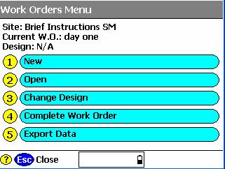
4 Before starting the Hydrographic survey, be sure to check the system setup by measuring a bench mark. Start SCS900 and create a new Work Order Select the site or create a new one (A site contains the items mentioned above) in this case a new site is created. In the new site, the various files are selected, a minimum is the site calibration file (DC file) in order to get the proper coordinate system, or a csv file containing control points (Since it is recommended to check the system setup, a.csv file is important). Currently this site calibration can contain a Geoid model, but CAN NOT contain a shiftgrid!.. If no calibration file (DC) is at hand, it is possible to calibrate the site using the known points in the.csv file. Simply select calibrate site in the Systems Setup menu System Settings It is possible to set the required accuracies under Settings, this can vary from one jobsite to another. There is a difference in acceptance criteria (will it store a position and depth or not) and the Calibration tolerance (will it accept a System Setup check)


, if it uses an internal,")
 A")


 and on vehicle mode (yellow quad) Those")

5 System Setup No wit is time to start the rover, Select System Setup and Setup Rover, or go directly to Measure Surface. Topo Surface and SCS900 will prompt you to set up a GPS rover. In this process, follow the instructions on screen The instructions will take you step by step trough the system setup. It will ask you if the receiver is connected by cable or Bluetooth (a), if it uses an internal, external radio or other correction method (b), and the coverage map grid size and antenna height (c) A B C Once started, SCS900 will ask you if you want to check the system setup, it is advised to do so. After the System Setup is completed and checked, the topo survey can start. Bear in mind there are survey methods, shown in the top left corner. These are Standing (red figure) Walking (yellow figure) and on vehicle mode (yellow quad) Those methods automatically set the position update rate and the different antenna heights. Changing this mode can be done by clicking it. For a hydrographic survey, select the vehicle mode (click here) and enter the height from the bottom of the transducer to the bottom of the antenna.

 Check display Point Elevations and select OK.")
 and a code (tip, this code can be used to identify a cross section number or profile number) After")
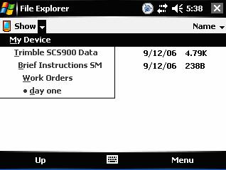
6 Finally select the measurement density required for the job, this will make the system log at a minimum interval or elevation change. Are you recording the bottom? In order to check if the system is indeed setup to record the bottom, look at the difference of the elevation shown on top of the screen and the recorded point elevation. To annotate points with their elevation, select the take the following steps. Select the button 123 Des (buttons may be changed by selecting the black triangle) Check display Point Elevations and select OK. Remember that if loads of points are stored, this option can slow down the CE device and make the map hard to read, so switch of again if required. Now Start a measurement, SCS900 will prompt you for a point name (this will increment automatically) and a code (tip, this code can be used to identify a cross section number or profile number) After selecting OK again, a point is measured and stored, annotated with the actual height. In this example, the elevation of the bottom of transducer was 5.330, the measured depth was (bucket) and the bottom is in that case Complete Work Order Once finished with the survey, the export files are written in the export folder those files consist of a record.txt and report.txt optional a DXF can be written but remember this can consume a lot of memory.
7
TDS Nomad Connect To Bluetooth Instrument. Tested with Trimble Nomad with integrated Bluetooth, and Sokkia 530R3 total station.
 TDS Nomad Connect To Bluetooth Instrument Tested with Trimble Nomad with integrated Bluetooth, and Sokkia 530R3 total station. Configure a Bluetooth COM Port (FIRST TIME ONLY) Before starting, exit from
Setup a VSN Survey Style Using Trimble Access (MiFi Card)
") Setup a VSN Survey Style Using Trimble Access (MiFi Card) California Surveying & Drafting Supply Technical Support Services Notes: This tutorial is designed for users with a MiFi Card/VSN Setup. In order
Setup a VSN Survey Style Using Trimble Access (MiFi Card) California Surveying & Drafting Supply Technical Support Services Notes: This tutorial is designed for users with a MiFi Card/VSN Setup. In order
Setup a VSN Survey Style Using Trimble Access (Bluetooth Phone)
") Setup a VSN Survey Style Using Trimble Access (Bluetooth Phone) California Surveying & Drafting Supply Technical Support Services Notes: This tutorial is designed as a tutorial for users with a cell phone/vsn
Setup a VSN Survey Style Using Trimble Access (Bluetooth Phone) California Surveying & Drafting Supply Technical Support Services Notes: This tutorial is designed as a tutorial for users with a cell phone/vsn
Table of Contents 1 PURPOSE SCOPE DEFINITIONS PROCEDURE... 5
 Table of Contents 1 PURPOSE... 3 2 SCOPE... 3 3 DEFINITIONS... 4 4 PROCEDURE... 5 4.1 Overview - Performing a Site Calibration... 5 4.1.1 Upload Mine Grid Control... 6 4.1.2 Obtain SSM Data... 7 4.1.3
USER GUIDE. Trimble Positions software suite: Trimble Positions Mobile extension. Introduction. Transferring data between the field and the office
 USER GUIDE Trimble Positions software suite: Trimble Positions Mobile extension Introduction Transferring data between the field and the office How the extension works Finding additional information Appendix
SonarMite Plus Bluetooth App.
 SonarMite Plus Bluetooth App. version 1.0 The SonarMite+ App is based on the free SonarMite App but offering additional features. The software is an Android App designed to work with the popular SonarMite
TRIMBLE ACCESS TRIMBLE ACCESS PROJECTS AND JOBS GUIDE
 TRIMBLE ACCESS TRIMBLE ACCESS PROJECTS AND JOBS GUIDE Version 2018.10 Revision A August 2018 Contents Projects & jobs 3 Managing projects 6 To create a local project 7 File transfer 7 Trimble data folders
TRIMBLE ACCESS TRIMBLE ACCESS PROJECTS AND JOBS GUIDE
 TRIMBLE ACCESS TRIMBLE ACCESS PROJECTS AND JOBS GUIDE Version 2018.00 Revision A June 2018 Contents Projects & jobs 3 Managing projects 6 To create a local project 7 File transfer 8 Trimble data folders
DASHBOARD OPERATION MANUAL. Machine Control, Inc.
 DASHBOARD OPERATION MANUAL Machine Control, Inc. INTEGRATE YOUR DATA With highly accurate topographic data describing your job site, its easy to envision and design a multiphase system to address your
TECHNICAL NOTES TRIMBLE SURVEY CONTROLLER SOFTWARE
 TRIMBLE SURVEY CONTROLLER SOFTWARE TECHNICAL NOTES The Trimble Survey Controller software is the data collection solution that will make your survey work faster, easier, and more productive than ever before.
Box Calibration: Here I entered points 3 and 4 which are the only control points given to us in the plans.
 Box Calibration: Trimble machine control does not like files that are derived from State Plane Coordinates or files that contain a Geoid. Trimble representatives want everyone to do a site calibration
USER GUIDE. Trimble SCS900 software
 USER GUIDE Trimble SCS900 software Version 3.5.1 Revision A April 2016 1 Corporate Office Trimble Navigation Limited 935 Stewart Drive Sunnyvale, CA 94085 USA www.trimble.com Heavy Civil Construction Division
Instrument Manual. Interface to Trimble Access (including Survey Controller)
") Instrument Manual Interface to Trimble Access (including Survey Controller) Contents Introduction... 3 Chapter 1 LSS install... 4 1.1 Install LSS, 3D Vision, Tutorials and Testdata... 4 1.2 Survey instrument
Instrument Manual Interface to Trimble Access (including Survey Controller) Contents Introduction... 3 Chapter 1 LSS install... 4 1.1 Install LSS, 3D Vision, Tutorials and Testdata... 4 1.2 Survey instrument
Trimble Access: OSTN15 Transformation Update Procedure (Ireland)
") Trimble Access: OSTN15 Transformation Update Procedure (Ireland) This guide is for use with Trimble Access version 2016.03 & previous versions Prerequisites: Access Controller (Nb. TSC3 used in this guide)
Trimble Access: OSTN15 Transformation Update Procedure (Ireland) This guide is for use with Trimble Access version 2016.03 & previous versions Prerequisites: Access Controller (Nb. TSC3 used in this guide)
QUICK START GUIDE. SOLO Forest
 QUICK START GUIDE SOLO Forest Software Installation 1. For PC installation, run the.msi file. 2. For Mobile device installation, copy the.cab file onto the device 3. Run the.cab file Starting the Program
TRIMBLE ACCESS PIPELINES USER GUIDE
 TRIMBLE ACCESS PIPELINES USER GUIDE Version 2018.00 Revision A June 2018 Contents Introduction 4 Jobs, tallies and joint maps 5 Stakeout 9 Pipelines jobs 10 To configure Pipeline options 10 To link weld
REFERENCE. Section 6. Field Use Tutorial 2-1
 REFERENCE Section 6 Field Use Tutorial 2-1 REFERENCE 2-2 Field Use Overview RTK GPS support is an additional feature in Sitework 4D, which must be purchased separately. In addition to creating takeoffs
technical notes Trimble survey controller field software
 Trimble survey controller field software technical notes For more than a decade, Trimble Survey Controller field software has provided land surveyors with a complete GNSS and optical data-collection solution
Export Metadata. Learning Objectives. In this Job Aid, you will learn how to export metadata: 1 For a location 3 2 From search results 7
 Export Metadata Learning Objectives In this Job Aid, you will learn how to export metadata: 1 For a location 3 2 From search results 7 Last updated: July 8, 2013 Overview You can export content metadata
Using the Leica Rover. A guide to locating And capturing locations Using the Leica GPS1200 Rover. Cleveland Utilities
 Using the Leica Rover A guide to locating And capturing locations Using the Leica GPS1200 Rover Cleveland Utilities Last Updated: Nov 23, 2004 Table of Contents Title Page Microstation to Field...1 4 Field
Support. TerraSync. Advanced Data Collection Techniques MGIS. Summary. Advanced Data Collection Options
 TerraSync MGIS Advanced Data Collection Techniques Support Summary Advanced data collection methods offer time-saving techniques for efficient field work. Step-bystep instructions are provided for: Advanced
This guide will show you how to configure a Windows Mobile 5 PDA for Bluetooth connection to the KBM Systems OBDKey Bluetooth device.
 This guide will show you how to configure a Windows Mobile 5 PDA for Bluetooth connection to the KBM Systems OBDKey Bluetooth device. You should first connect the OBDKey device to the vehicle and the vehicle
TopSURV: Collecting field data using the Auto Topo function. Oscar R. Cantu
 TopSURV: Collecting field data using the Auto Topo function Oscar R. Cantu Have a Question? At anytime during today s webinar, if you have any questions, please type them within the Questions section of
SCS900 SITE CONTROLLER SOFTWARE USER GUIDE
 SCS900 SITE CONTROLLER SOFTWARE USER GUIDE Version 3.61 Revision A July 2017 Corporate Office Trimble Inc. 935 Stewart Drive Sunnyvale, CA 94085 USA www.trimble.com Product Limited Warranty Information
12d Model v8 interface to Trimble instruments 2007
 These notes describe the interfacing of 12d version 8 with the Trimble surveying instruments. 1) Installing Trimble link Trimble link must be installed prior to attempting to upload or download data to
THALES NAVIGATION. FAST Survey. Field Guide.
 THALES NAVIGATION FAST Survey Field Guide www.thalesnavigation.com Printed in France. Part Number: 630887-01, Revision A. No part of this publication or the computer programs described in it may be reproduced,
BT-335 Bluetooth Data Logger User Manual. Version 1.2
 BT-335 Bluetooth Data Logger User Manual Version 1.2 BT-335 page 2 Table of Content 1 Introduction and Features... 3 Introduction...3 Features...3 2 Specifications... 4 System Specifications...4 Bluetooth
Quick Start: GeoDAS-LT with Single Beam Echo Sounder
 Quick Start: GeoDAS-LT with Single Beam Echo Sounder I. Setting up GeoDAS-LT for Single Beam Echo Sounder Survey 1. Connect your single beam echo sounder, GPS receiver and other sensors (e.g. gyro and
Sokkia GSR 2700 ISX GPRS Configuration
 Sokkia GSR 2700 ISX GPRS Configuration You must be using FieldGenius 2008 v4.0.1 or newer. Start Settings Coordinate System Coordinate System Settings Access this screen by going to Start Settings Coordinate
Interpretype Bluetooth Setup Procedure
 This information is for configuring the Interpretype to communicate using the Bluetooth Connectivity Kit. To communicate using LAN or Wi-Fi in the full featured version of our software, please refer to
v SMS 12.2 Tutorial Observation Prerequisites Requirements Time minutes
 v. 12.2 SMS 12.2 Tutorial Observation Objectives This tutorial will give an overview of using the observation coverage in SMS. Observation points will be created to measure the numerical analysis with
MaCORS Quick Guide. Rover Configuration for Topcon GR 3 using Carlson SurvCE 2.x & Internal CDMA Modem
 MaCORS Quick Guide Rover Configuration for Topcon GR 3 using Carlson SurvCE 2.x & Internal CDMA Modem This Quick Guide outlines configuring the Topcon GR 3 with Carlson SurvCE & Internal CDMA modem to
Trimble Access and Trimble SX10 Scanning Total Station Guide
 Trimble Optical and Field Software October 2016 Trimble Access and Trimble SX10 Scanning Total Station Guide Trimble SX10 Scanning Total Station Innovative True merging of high-speed scanning, enhanced
Observation Coverage SURFACE WATER MODELING SYSTEM. 1 Introduction. 2 Opening the Data
 SURFACE WATER MODELING SYSTEM Observation Coverage 1 Introduction An important part of any computer model is the verification of results. Surface water modeling is no exception. Before using a surface
Technical Note. 12 August 2009 PocketDTM Utility Surveys Brief Outline. Atlas Computers Ltd
 Technical Note 12 August 2009 PocketDTM Utility Surveys Brief Outline Atlas Computers Ltd 15 Moyville Lawns Taylors Lane Rathfarnham Dublin 16 Republic of Ireland Ph: +353(0) 1 4958714/5/6 Fax: +353(0)
INLAND GPS. Exporting a geoid model to Trimble Survey Controller data collectors
 TECHNICAL TIPS from INLAND GPS Exporting a geoid model to Trimble Survey Controller data collectors This Technical Tip provides instructions for exporting a geoid model or a portion thereof to a data collector
Using ArcPad and GPS Correct 3.31
 Using ArcPad 10.02 and GPS Correct 3.31 Class objectives: Understanding GPS Configuring ArcPad for data collection Field data capture with ArcPad Data collection Navigation Offsets Editing Creating New
TcpGPS. User Manual. Installation. The steps below must be followed:
 TcpGPS User Manual Installation The steps below must be followed: 1. Decompress the file TcpGPSSetup.zip. 2. Execute the file vcredist_x86_vs2008.exe. This application will install the libraries required
Topcon Link Quick Reference Guide
 Topcon Link Quick Reference Guide Part Number 7040-0027 Rev B Copyright Topcon Positioning Systems, Inc. May, 2003 All contents in this manual are copyrighted by Topcon Positioning Systems, Inc. All rights
APS-3 with FieldGenius Configuration Manual
 APS-3 with FieldGenius Configuration Manual Version 1.3 Table of contents 1 Getting Started... 2 1.1 Hardware requirements... 2 1.2 Installing FIELDGenius... 2 2 Septentrio FIELDGenius Startup... 3 2.1
a) From Cognos Connection, tick the report you want to copy, and click on the Copy command in the tool bar, top right of screen
 From Cognos Connection, tick the report you want to copy, and click on the Copy command in the tool bar, top right of screen") Cognos Report View Cognos provides the functionality of being able to save your parameter choices for any of the reports. This is useful if you always choose the same department(s), cost centre(s) or source
Cognos Report View Cognos provides the functionality of being able to save your parameter choices for any of the reports. This is useful if you always choose the same department(s), cost centre(s) or source
Quick Reference Card
 with the FieldLevel II Automated Levelling System Quick Reference Card f g h i j e Run screen layout d c l m n o p q r k s Item Description Item Description c d e Cut / Fill map The difference between
INLAND GPS. TECHNICAL TIPS from. MyMobiler Free remote display for Trimble TSC2
 TECHNICAL TIPS from MyMobiler Free remote display for Trimble TSC2 This Technical Tip provides information on installing, configuring, and using a free remote-display utility named MyMobiler that works
Integrating the Measurand Shape Accelerometer Arrays (SAA) Sensor Application Note #19
 Sensor Application Note #19") 5 Gould Road, PO Box 2155 New London, NH 03257 USA Voice: (603) 526-9800 info@canarysystems.com www.canarysystems.com Integrating the Measurand Shape Accelerometer Arrays (SAA) Sensor Application Note
5 Gould Road, PO Box 2155 New London, NH 03257 USA Voice: (603) 526-9800 info@canarysystems.com www.canarysystems.com Integrating the Measurand Shape Accelerometer Arrays (SAA) Sensor Application Note
Trimble Recon Handheld: Using the Socket Bluetooth CompactFlash Card
 31 August 2006 Trimble Recon Handheld: Using the Socket Bluetooth CompactFlash Card This document explains how to use the Socket Bluetooth CompactFlash card on the Trimble Recon handheld running the Microsoft
Soil and Water Conservation Laboratory Standard Operating Procedure
 Soil and Water Conservation Laboratory Standard Operating Procedure Sherman 230, Soil and Water Conservation Laboratory, UH Mānoa Collecting GPS data with the Trimble handheld through ArcGIS & related
CAPS Computer Aided Product Selection Program
 CAPS Computer Aided Product Selection Program This instructional guide includes: Improve and Increase Your Design Throughput and Productivity with CAPS....... 3 1. Create a My Greenheck Account............................
USER S MANUAL v.2. Settop CellXtrem
 USER S MANUAL v.2 Settop CellXtrem Rev. January 2016 USER S MANUAL 2 Index Index... 2 Settop CellXtrem... 3 Become familiar with the Settop CellXtrem... 4 Battery... 4 Coverage Level... 4 Client LED (Rover)...
Trimble Survey Controller. Release Notes
 Trimble Survey Controller Release Notes Version 10.5 Revision A September 2002 Corporate Office Trimble Navigation Limited Engineering and Construction Division 5475 Kellenburger Road Dayton, Ohio 45424-1099
Trimble SCS900 Site Controller Software for Beginners. Jordan Lawver HCC-6339
 Trimble SCS900 Site Controller Software for Beginners Jordan Lawver HCC-6339 Agenda What is Trimble SCS900 Site Controller Software? Who uses SCS900 Trimble Site Positioning System software portfolio Applications
Network Management Software ALLNET Zone Controller
 Network Management Software ALLNET Zone Controller For ALL0558N / ALL02850N / ALL02860ND / ALL02880ND User Manual v1.0 Table of Contents 1. Installation & Un-installation... 4 1.1. Install NMS Suite...
Add Address User s Manual
 Add Email Address User s Manual Contents Welcome... 2 Configuring the Add-in... 3 Settings Tab... 4 Scan Now Tab... 6 Advanced Tab... 7 Troubleshooting... 8 Add Email Address Copyright 2008 2017 Sperry
Farm Works Mobile with Geonics Sensors
 Farm Works Mobile with Geonics Sensors Introduction. Farm Works Mobile is a mobile mapping, scouting and data logging program from Trimble. Farm Works Mobile is designed to communicate via an RS232 serial
Legal Notes. Regarding Trademarks KYOCERA MITA Corporation
 Legal Notes Unauthorized reproduction of all or part of this guide is prohibited. The information in this guide is subject to change without notice. We cannot be held liable for any problems arising from
TABLE OF CONTENTS. Introduction...1. Setting Up the System...1. Entering Data in the Field...4. Customizing Selection Options...10
 TABLE OF CONTENTS Introduction...1 Setting Up the System...1 Minimum System Requirements...1 Installing RRIP Application...1 Setting Output File Path for PDF Writer...2 Entering Data in the Field...4 Customizing
trimble r10 GNSS System
 TRIMBLE R10 SERIES RECEIVER QUICK START GUIDE trimble r10 GNSS System C Warning: For safety information, refer to the Safety Information section of the Trimble R10 GNSS Receiver User Guide. Five simple
Contents. Introduction... iii. CHAPTER 1 - Getting Started... 5
 Transducer Characterization User s Guide Version 5 5 1 build 12 or later UTEX Scientific Instruments Inc support@utex com Winspect Transducer Characterization User s Guide Contents Table of Contents and
Altus APS3 Configure Rover for Radio, NTRIP or GPRS RTK Link
 Altus APS3 Configure Rover for Radio, NTRIP or GPRS RTK Link You must be using FieldGenius 2010 v4.3.0 or newer. This document was written using FieldGenius 2010 v4.3.0.11 Coordinate System Settings Coordinate
RELEASE NOTES TRIMBLE ACCESS SOFTWARE
 RELEASE NOTES TRIMBLE ACCESS SOFTWARE Version 2014.20 Revision A October 2014 1 Legal Information Trimble Navigation Limited Engineering Construction Group 935 Stewart Drive Sunnyvale, California 94085
v Overview SMS Tutorials Prerequisites Requirements Time Objectives
 v. 12.2 SMS 12.2 Tutorial Overview Objectives This tutorial describes the major components of the SMS interface and gives a brief introduction to the different SMS modules. Ideally, this tutorial should
X PAD Construction 2.5.5
 News X PAD Construction January 2014 X PAD Construction 2.5.5 This document contains a list of all changes, new features, bug fixed introduced in this last version of X PAD Construction. GPS RTCM3.1: RTCM3.1
SPARK-E-MATE BLUETOOTH LOGGING
 SPARK-E-MATE BLUETOOTH LOGGING PRODUCT: MOBILE DEVICES: CUSTOMER: Spark-e-mate 493BTL & 493BTLi (DRWG PC-5157-2) PCs & Laptops, Android Devices, ios Devices Schneider Electric Document Control Document
VERSION DTS USER MANUAL
 VERSION 1.7.0 DTS USER MANUAL CONTENTS Quick Start Overview... 3 Access Groups... 3 Employees... 3 Location Type... 3 Item Type... 3 Custom Images... 3 Locations... 3 Items... 3 Printer Assignment... 4
Contents Overview... 3 Steps to run an Excel Add-In Setup:... 4 Add-Ins LOGIN SEND SMS Send Text or Flash Sms... 1
 User Manual IND-BulkSms Excel Add-In Version 1.0 Contents 1 2 3 4 5 6 7 Overview... 3 Steps to run an Excel Add-In Setup:... 4 Add-Ins... 11 LOGIN... 12 SEND SMS... 13 5.1 Send Text or Flash Sms... 13
Importing GNSS Data SPECTRA PRECISION SURVEY OFFICE TUTORIAL
 Importing GNSS Data SPECTRA PRECISION SURVEY OFFICE TUTORIAL Corporate office: Spectra Precision 10355 Westmoor Drive Suite #100 Westminster, CO 80021 USA Phone: +1-720-587-4700 Toll free (in USA): +1-888-477-7516
NAVIPAC 4 INTRODUCTION AND WORKFLOW
 NAVIPAC 4 INTRODUCTION AND WORKFLOW Contents 1 Introduction to NaviPac... 3 2 Program Environment... 4 3 Hardware environment... 7 4 Workflow example... 8 4.1 Workflow: Creating a configuration... 9 4.1.1
Scepter / Scepter II Getting Configured for Real Time Networks with an Internet Hot Spot
 a. Turn Your Mi-Fi, Cell Phone or other Internet Hot Spot On b. Turn Your Scepter Data Collector On 1 c. In the center of the data collector tap Wi-Fi a. Tap Menu in the bottom Right Corner and then Wi-Fi
Instruction Manual. ALMEMO 500 Data logger with app. Produktpräsentationsbild mit grünen, schrägen Balken links.
 www.ahlborn.com Produktpräsentationsbild mit grünen, schrägen Balken links Instruction Manual ALMEMO 500 Data logger with app V7 Technology ALMEMO 500 English V2.0 21.06.2018-1 1 Global Overview Global
RELEASE NOTES. Trimble Access Software
 RELEASE NOTES Trimble Access Software Version 2017.11 Revision A March 2018 1 Legal Information Trimble Inc. www.trimble.com Copyright and Trademarks 2009 2018, Trimble Inc. All rights reserved. Trimble,
Interface to icon Construction Instruments and Machine Control
 Interface to icon Construction Instruments and Machine Control CONTENTS 1. Preamble 2. Install and Configure LSS 3. Exporting data to Leica Machine Control (Scanlaser) 4. Importing LSS exported files into
v Getting Started An introduction to GMS GMS Tutorials Time minutes Prerequisite Tutorials None
 v. 10.3 GMS 10.3 Tutorial An introduction to GMS Objectives This tutorial introduces GMS and covers the basic elements of the user interface. It is the first tutorial that new users should complete. Prerequisite
Introduction. Automatic gate opening no more swiping
 Introduction This user guide is intended for companies and drivers to use the functionality available in the TAMS System Manage your entire Auckland Airport access account via the internet! One simple
Trimble Survey Controller. Release Notes
 Trimble Survey Controller Release Notes Version 7.70 Revision A January 2001 Corporate Office Trimble Navigation Limited Technical Publications Group 645 North Mary Avenue Post Office Box 3642 Sunnyvale,
ESET Mobile Security for Windows Mobile. Installation Manual and User Guide - Public Beta
 ESET Mobile Security for Windows Mobile Installation Manual and User Guide - Public Beta Contents...3 1. Installation of ESET Mobile Security 1.1 Minimum...3 system requirements 1.2 Installation...3 1.2.1
v Observations SMS Tutorials Prerequisites Requirements Time Objectives
 v. 13.0 SMS 13.0 Tutorial Objectives This tutorial will give an overview of using the observation coverage in SMS. Observation points will be created to measure the numerical analysis with measured field
WMS 10.0 Tutorial Storm Drain Modeling SWMM Modeling Learn how to link a hydrologic model to the SWMM storm drain model
 v. 10.0 WMS 10.0 Tutorial Learn how to link a hydrologic model to the SWMM storm drain model Objectives Build a rational method hydrologic model and compute sub-basin flows. Import storm drain network
User Manual RouteSms SmsPlus Desktop. Version 1.0
 User Manual RouteSms SmsPlus Desktop Version 1.0 1. Content : 1 INTRODUCTION...... 3 2 LOGIN... 4 3 WELCOME PAGE...... 5 4 SEND SMS...... 6 4.1 SINGLE SMS:... 6 4.2 BULK SMS:... 7 4.3 PERSONALIZED BULK
WMS 9.1 Tutorial Storm Drain Modeling SWMM Modeling Learn how to link a hydrologic model to the SWMM storm drain model
 v. 9.1 WMS 9.1 Tutorial Learn how to link a hydrologic model to the SWMM storm drain model Objectives Build a rational method hydrologic model and compute sub-basin flows. Import storm drain network information
ACT! Calendar to Excel
 Another efficient and affordable ACT! Add-On by ACT! Calendar to Excel v.6.0 for ACT! 2008 and up http://www.exponenciel.com ACT! Calendar to Excel 2 Table of content Purpose of the add-on... 3 Installation
User Manual JOFRACAL for JOFRA Pressure Calibrators. Copyright 2007 AMETEK Denmark A/S
 User Manual JOFRACAL for JOFRA Pressure Calibrators Copyright 2007 AMETEK Denmark A/S 2 126690 02 LIST OF CONTENTS Page 1. INTRODUCTION... 11 1.1 General information... 12 1.2 Hardware requirements...
Compass Solution Getting Started Guide
 Compass Solution Getting Started Guide ComNav Technology Ltd. www.comnavtech.com Content Chapter 1 Software introduction... 2 1.1 Function introduction... 2 1.2 Compass Solution user interface introduction...
GETTING STARTED GUIDE
 GETTING STARTED GUIDE Trimble Variety Tracking System Introduction Getting the most out of the Trimble Variety Tracking system Preparing for installation Calibrating the system Recording varieties during
What s New in Configura 9.2?
 What s New in Configura 9.2? March 27, 2017 64-bit Preparations Completed We have completed all necessary preparations for implementing 64-bit customizations. The main benefit with 64-bit is that Configura
Setting up Hydromagic:
 To operate Eye4Software Hydromagic and RosePoint ECS software packages simultaneously, the CEESCOPE echo sounder must be connected to the acquisition PC using the Ethernet (LAN) cable. The two software
C3CAP Clara User Manual
 C3CAP Clara User Manual Table of Contents C3CAP... 4 Clara... 4 Types of People... 4 Client:... 4 Users:... 4 Super Users:... 4 Vendor:... 4 Register to use Clara... 5 Assistance Requests... 5 Log into
1.1 ing an Individual Contact or Selected Contacts (Non Synchronous)
") USC Marshall School of Business Marshall Information Services Outlook 2013 Sharing Contacts and Distribution Lists There are several method available for sharing contacts. 1.1 Emailing a Single or Selected
USC Marshall School of Business Marshall Information Services Outlook 2013 Sharing Contacts and Distribution Lists There are several method available for sharing contacts. 1.1 Emailing a Single or Selected
Quick Reference Guide
 Quick Reference Guide Envizio Pro & Envizio Pro II Overview The Envizio Pro and Envizio Pro II are all-in-one field computers capable of providing product control for up to four products (with required
HP SmartTracker. User Guide
 HP SmartTracker User Guide 2018 HP Development Company, L.P. Edition 3 Legal notices The information contained herein is subject to change without notice. The only warranties for HP Products and services
How to Convert a Scored MMPI -2 Report to an MMPI-2-RF Report Using Q Local
 How to Convert a Scored MMPI -2 Report to an MMPI-2-RF Report Using Q Local 2.2.22 This document will walk you through exporting a scored MMPI-2 using Q Local 2.2.22. Conversion is essentially a three-step
Efento Transport user manual (ver or newer)
") Efento Transport user manual (ver. 2.0. or newer) Installation Download and install Efento Transport application from Google Play. The application is free of charge and is compatible with devices running
Efento Transport user manual (ver. 2.0. or newer) Installation Download and install Efento Transport application from Google Play. The application is free of charge and is compatible with devices running
9 Working With DICOM. Configuring the DICOM Option
 9 Working With DICOM DICOM (Digital Imaging and Communications in Medicine) is a format created by NEMA (National Electrical Manufacturers Association) to aid in the distribution and viewing of medical
Auto Print User s Manual
 Auto Print User s Manual Welcome... 2 Configuring the Add-in... 3 AutoPrint Incoming Email Tab... 4 AutoPrint Outgoing Email Tab... 6 Print Settings Tab... 7 Print Now Tab... 9 Exceptions Tab... 10 Troubleshooting...
Android User Guide. for version 5.3
 Android User Guide for version 5.3 Contents 1. Installation... 3 1.1. How to install Babelnet... 3 1.2. Enter Babelnet in the search field.... 3 1.3. Safety precautions when using Babelnet on your Android...
APS-3 with Seismic Surveyor
 APS-3 with Seismic Surveyor Configuration Manual Revision 1.01 Page 1 APS-3 with Seismic Surveyor, Configuration Manual 2011 ALTUS Positioning Systems Inc. All rights reserved. ALTUS, the ALTUS logo, and
Introduction to Solo Forest
 Introduction to Solo Forest Project Settings Collecting Data Office Procedures - Exporting Shapefiles - Syncing with the PC - Transferring files Opening Solo Forest To open Solo Forest, select Start >
INSTRUCTION MANUAL. BTManager 2.0. for FC-200 with Windows CE5.0
 INSTRUCTION MANUAL BTManager 2.0 for FC-200 with Windows CE5.0 64852 90190 Table of Contents TOC Getting Started with Bluetooth Manager... 1-1 Starting Bluetooth Manager... 1-1 Getting Acquainted... 1-2
PI3000. User Guide PASSENGER INFORMATION SYSTEM. rev 1.2
 PI3000 PASSENGER INFORMATION SYSTEM User Guide rev 1.2 PLEASE READ THIS FIRST! Insurance The security dongle has significant value and is the key to your system and your charts. It is not possible to replace
NORDSON CORPORATION AMHERST, OHIO USA
 CanWorks Operator Interface Tracking PLUS for CanWorks Systems with SM-2 Spray Monitors User Guide Part 1018132A NORDSON CORPORATION AMHERST, OHIO USA 2002 Nordson Corporation. All rights reserved. CanWorks,
5 Setting Preferences 15 Preferences 15 Configure Chart Colors 16
 CRITERION Vantage 3 Acquire Training Manual Contents 1 Introduction 3 Collecting Data 3 2 Starting the Program 3 Logging In and Logging Out 3 Logging In 3 Logging in as an Administrator 3 Logging in as
Course Code: ServiceMaxx Overview and Snapshot Analysis Study Guide
 Course Code: 8798 ServiceMaxx Overview and Snapshot Analysis Study Guide 2015 Navistar, Inc. 2701 Navistar Drive, Lisle, IL 60532. All rights reserved. No part of this publication may be duplicated or