Basic Backward Trajectory to GIS Instructions
|
|
|
- Jocelin Mathews
- 6 years ago
- Views:
Transcription

1 Introduction Basic Backward Trajectory to GIS Instructions NOAA s Hysplit Modeling software is available for use on the Internet. The software can be used to create forward plumes from a source, as well as backward trajectories from a monitor. One use for this software is to track the path a particle of air took when you have high concentrations during ambient air monitoring. If you have sources on GIS, and the air passed near that source before it got to your monitor, that source may be suspected of having contributed to the high concentration. Of course, this intuitive analysis is subject to a variety of interpretations and caveats. Still, it is a valuable tool that can be used to help understand air quality issues in an area. This paper describes one method of obtaining a basic backward trajectory and integrating the trajectory into GIS software. Other software could be used. The software used in this document was selected because it is available to many tribal environmental employees. Go to: Click 1 of 22

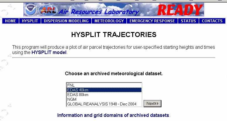
2 Click Select Click 2 of 22
3 Select date. Dec is December is day 1 to 15, 002 is day 16 to the end of the month) Click Enter the Latitude and Longitude of the monitoring site, and then click next 3 of 22
.")
4 Select Backward Select start time (UTC) see below for conversion info For a single basic trajectory 0 and 1 Set Start height Above Ground Level (AGL) to monitor inlet probe Leave the rest at their default positions A backward trajectory traces the path a particle of air took from the time entered backward. The start time must be entered to HYSPLIT in UTC (Universal Time). Use the following table to convert Local Standard Time (not Daylight Savings) to UTC. To convert Eastern Standard to UTC: Add 5 Hours to local time To convert Central Standard to UTC: Add 6 Hours to local time To convert Mountain Standard to UTC: Add 7 Hours to local time To convert Pacific Standard to UTC: Add 8 Hours to local time Example 1: A trajectory starting at 14:00 (2 pm) Central Standard Time (CST) is entered as 20 UTC the same day ( = 20) Example 2: A trajectory starting at 19:00 (7 pm) CST is entered as 1 UTC the next day ( = 25 or 1 the next day consider the day when converting start times) 4 of 22

5 Click Click 5 of 22
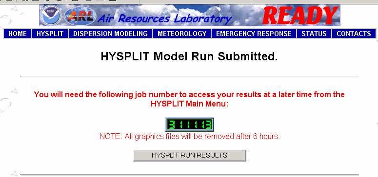
6 Click Notice This will be used later to get a text file that can be used in GIS 6 of 22
7 The particle of air 24-hours earlier Monitoring site Elevation at monitoring site Elevation 24- hours earlier Return to the Internet Browser 7 of 22
8 Click The popup file you just looked at now has text. Save the text. 8 of 22


9 Click File and Save As Name the file and select a location to save the file to. Then click save 9 of 22


10 Open Microsoft Excel and point it to the file you just downloaded Click 2. Select the file you just downloaded 3. Open 1. Select Text Files so you can see the text file you just downloaded 10 of 22


11 Click Delimited Then Next 2. Select and deselect delimiters until columns form that make sense 1. Scroll down to see data This is space-delimited data columns make sense when Space is selected 11 of 22

12 12 of 22 Add headers to the columns you will keep


13 Delete the rows above the headers you just created. Click on row numbers. Hold down the Ctrl key to select more than 1 row. Then right click over the row numbers and choose delete Delete the columns you don t need. Select the column by clicking on the letter. Then right click over the letter and choose delete 13 of 22
.")
.")

14 Columns with the headers you made remain (Year, Month, Day, etc.). And are in the upper left corner (Year is in Column A, Row 1). Click File then Save As Save as Text. You may want to rename the file to keep the original file on your computer Click Yes 14 of 22


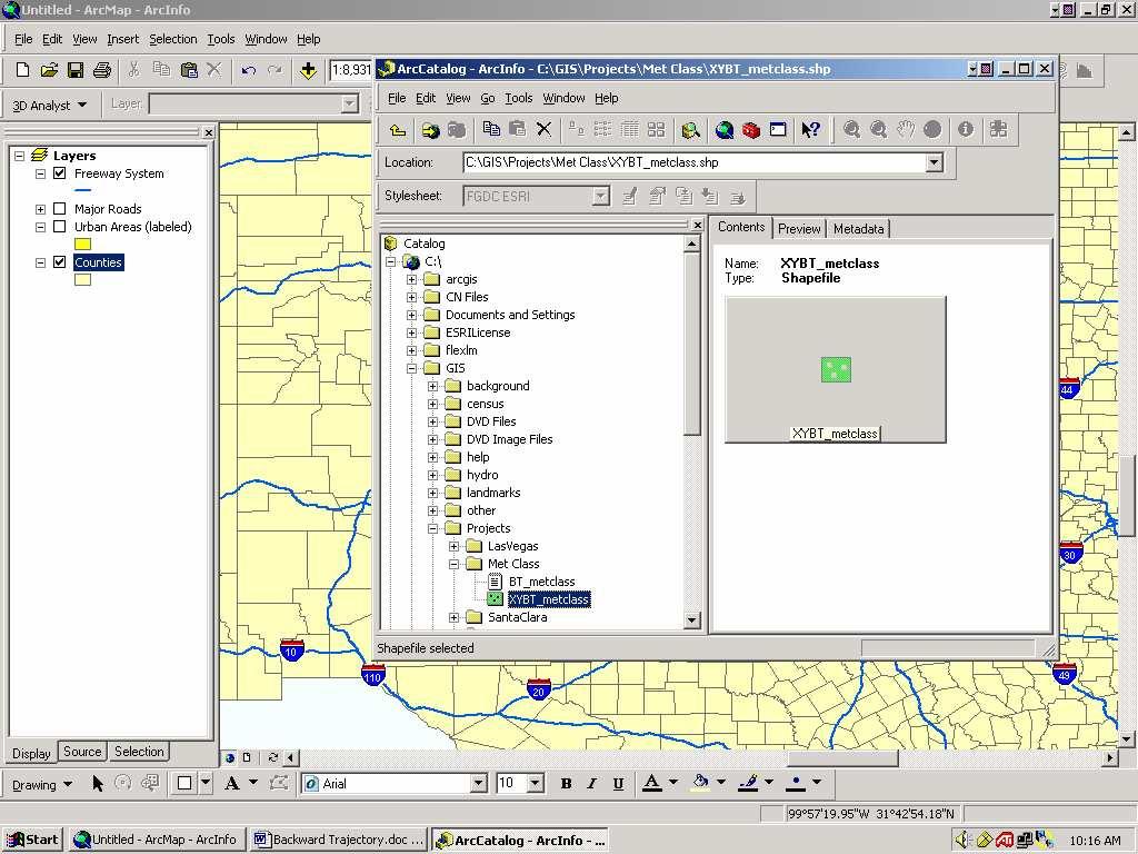
15 1. Close Microsoft Excel (click the x) 2. Click NO! Open ArcMap and then ArcCatalog Point ArcCatalog to the file you just edited. Note: ArcCatalog will only see files that existed BEFORE you opened it. To see files created after you have opened ArcCatalog, you must close and reopen ArcCatalog. 15 of 22


16 Right Click on the file and select Create Feature Class and then From XY Table Be Sure that X Field is Longitude and Y Field is Latitude. If not, use the dropdown box and select the correct field Click the open folder button and select where you want the shapefile to be saved (see next picture) 16 of 22

 17")
17 Select where you want the shapefile to be saved and click save Save Location Once the latitude, longitude, and save location are set correctly, click OK Close and reopen ArcCatalog (so you can see the shapefile just created) 17 of 22
18 18 of 22


19 In ArcCatalog, left click the shapefile you just created, HOLD your left click down and drag the file to the Layers display. Let go of the left click. Left click, hold and drag to move ArcCatalog s display, or minimize ArcCatalog. This dialog may be underneath. Click OK. You can check Don t warn me again and it will never show up again. Move display to expose dialog 19 of 22

20 The shapefile is now in GIS, but you can t see it on the right. It is under the Counties layer. Things higher up are seen first. In this case the Counties layer isn t transparent so it is hiding our shapefile. We will move the shapefile up the list by left clicking and dragging it up. 20 of 22
21 24-hours earlier Start point 21 of 22

22 The HYSPLIT backward trajectory text file provided latitude and longitude (and elevation) for the location of the particle of air at 1-hour intervals, backward in time from your selected start time and location. The GIS map shows the locations in a more easily understood image than the one at HYSPLIT. If you put sources on GIS it could point to sources suspected of contributing to air quality problems. 22 of 22
Using Smoke Modeling Tools for Prescribed Fire Planning and Implementation A Quick Set of Instructions (Revised December 2017)
") Using Smoke Modeling Tools for Prescribed Fire Planning and Implementation A Quick Set of Instructions (Revised December 2017) Fire Management Officers (FMOs) in Region 8 are using smoke modeling more
Using Smoke Modeling Tools for Prescribed Fire Planning and Implementation A Quick Set of Instructions (Revised December 2017) Fire Management Officers (FMOs) in Region 8 are using smoke modeling more
GPS to GIS Tutorial Exploration of Native Plants
 Grossmont College Introduction to GIScience NAME: Instructors: Curran & Goodman 1 GPS to GIS Tutorial Exploration of Native Plants 1. Create a folder on your USB drive titled: GPS1 2. Using your GPS receiver,
GPS TO GIS EXERCISE (30 PTS)
") GPS TO GIS EXERCISE (30 PTS) This exercise will allow you to demonstrate your cumulative knowledge of using a GPS receiver to collect data with locational information, downloading this data to a desktop
GPS TO GIS EXERCISE (30 PTS) This exercise will allow you to demonstrate your cumulative knowledge of using a GPS receiver to collect data with locational information, downloading this data to a desktop
Geographical mapping of data
 BioNumerics Tutorial: Geographical mapping of data 1 Aim In many research projects, especially epidemiological, biological data is closely linked to geographical data. Geographical information provided
IRA Basic Running Financial Reports
 IRA Basic Running Financial Reports Updated 6-7-2013 1 Training Index Part I Introduction to the IRA Reporting Tool IRA Resources (3) Logging onto the system (4) Navigating the Dashboard (5-9) Running
Excel 2007 New Features Table of Contents
 Table of Contents Excel 2007 New Interface... 1 Quick Access Toolbar... 1 Minimizing the Ribbon... 1 The Office Button... 2 Format as Table Filters and Sorting... 2 Table Tools... 4 Filtering Data... 4
Downloading Census Data from American Factfinder for use in ArcGIS
 Downloading Census Data from American Factfinder for use in ArcGIS Written by Barbara Parmenter, revised September 24 2013 OBTAINING DATA FROM AMERICAN FACTFINDER (AFF)... 1 PREPARING AMERICAN FACTFINDER
Downloading 2010 Census Data
 Downloading 2010 Census Data These instructions cover downloading the Census Tract polygons and the separate attribute data. After that, the attribute data will need additional formatting in Excel before
This document explains how to connect to a SQL Server database using ESRI ArcCatalog in order to extract data containing spatial coordinates.
 Arctic Network Arctic Network Data Management Standard Operating Procedure Inventory & Monitoring Program U.S. Department of the Interior Data Management Standard Operating Procedure NPS/ARCN/DMSOP-2009-07
Microsoft Powerpoint 2013
 Microsoft Powerpoint 2013 Lesson 4 Designing a Presentation 2014, John Wiley & Sons, Inc. Microsoft Official Academic Course, Microsoft Word 2013 1 Objectives 2014, John Wiley & Sons, Inc. Microsoft Official
Geocoding Reference USA data in ArcMap 10.1
 Geocoding Reference USA data in ArcMap 10.1 Written by Barbara Parmenter, revised 2/21/2014 GETTING BUSINESS DATA FROM REFERENCE USA BY NAICS AND CITY... 2 MODIFY YOUR EXCEL FILE... 5 STARTING ARCMAP...
Introduction to GIS software
 Introduction to GIS software There are a wide variety of GIS software packages available. Some of these software packages are freely available for you to download and could be used in your classroom. ArcGIS
Geocoding vs. Add XY Data using Reference USA data in ArcMap
 Geocoding vs. Add XY Data using Reference USA data in ArcMap 10.4.1 Written by Barbara Parmenter. Revised by Carolyn Talmadge 2/27/2017 GETTING BUSINESS DATA FROM REFERENCE USA BY NAICS AND CITY... 2 MODIFY
Select the Parks within Forest Acres
 Select the Parks within Forest Acres TASKS RESULT 1. Add the county boundary, municipalities and parks (pts.) layers to your map 2. Save your map (.mxd) to your desktop Your map should look something like
IRA Basic Running Financial Reports
 IRA Basic Running Financial Reports Dartmouth College maintains a data warehouse of institutional finances, student data, advancement giving and other important measures. Institutional Reporting and Analysis
Working with Macros. Creating a Macro
 Working with Macros 1 Working with Macros THE BOTTOM LINE A macro is a set of actions saved together that can be performed by issuing a single command. Macros are commonly used in Microsoft Office applications,
How to Remove Duplicate Rows in Excel
 How to Remove Duplicate Rows in Excel http://www.howtogeek.com/198052/how-to-remove-duplicate-rows-in-excel/ When you are working with spreadsheets in Microsoft Excel and accidentally copy rows, or if
Section 2: Downloading and Processing Data
 Downloading and Processing Data Joining Data Tables 2.1.1 Section 2: Downloading and Processing Data 2.1 Joining Data Tables Many times you will find a table of data that you want to map, perhaps as an
SSURGO Processing Tool
 SSURGO Processing Tool User Guide (Revised 08.02.11) Software Requirements: Setup_SWATioTools_094.exe Windows XP or Windows 7 32-bit with MS Office 2007 (Access and Excel) ArcGIS 9.3.1 SP2 Instructions
GEOG4017 Geographical Information Systems Lab 3 Data Collection and Integration (I)
") DEPARTMENT OF GEOGRAPHY HONG KONG BAPTIST UNIVERSITY Prof. Q. Zhou GEOG4017 Geographical Information Systems Lab 3 Data Collection and Integration (I) Objectives Before we can use GIS for any analysis
DEPARTMENT OF GEOGRAPHY HONG KONG BAPTIST UNIVERSITY Prof. Q. Zhou GEOG4017 Geographical Information Systems Lab 3 Data Collection and Integration (I) Objectives Before we can use GIS for any analysis
Chapter 7. Geocoding in ArcGIS Desktop (ArcMap)
") Chapter 7 Geocoding in ArcGIS Desktop (ArcMap) Summary: In many cases, online geocoding services are all you will need to convert addresses and other location data into geographic data. When you have a
Chapter 7 Geocoding in ArcGIS Desktop (ArcMap) Summary: In many cases, online geocoding services are all you will need to convert addresses and other location data into geographic data. When you have a
Quick Guide FAST HR. For more resources, including a guide on FAST HR codes, visit # Instructions Screenshot
 Tips & tricks This quick guide describes basic navigation within the FAST HR reporting tool, including how to use filter options, format columns and export reports. For more resources, including a guide
1. Start ArcMap by going to the Start menu > All Programs > ArcGIS > ArcMap.
 Learning ArcGIS: Introduction to ArcMap 10.1 The Map Document Feature Manipulation Navigating ArcMap Map Documents, Layers, and Features Shapes, Location, and Attribute Data Symbology Zoom, Pan and Map
Workshop #12 Using ModelBuilder and Customizing the ArcMap Interface
 Workshop #12 Using ModelBuilder and Customizing the ArcMap Interface Toolboxes can be created in ArcToolbox, in folders or within geodatabases. In this tutorial you will place the toolbox in your project
USING MICROSOFT ACCESS 2013 Guided Project 7-1
 Guided Project 7-1 For this project, you enhance the functionality of a database for a friend s music collection. You use Design view to create a main form and a subform, and customize the form to add
Exercise 1: Getting to know ArcGIS
 The Scenario You are working for the California Visitor s Commission. You have been asked to prepare a map of California for several dignitaries from out of the country. Your map will need to include enough
Geography 281 Mapmaking with GIS Project One: Exploring the ArcMap Environment
 Geography 281 Mapmaking with GIS Project One: Exploring the ArcMap Environment This activity is designed to introduce you to the Geography Lab and to the ArcMap software within the lab environment. Before
Geographical Information Systems Institute. Center for Geographic Analysis, Harvard University. LAB EXERCISE 1: Basic Mapping in ArcMap
 Harvard University Introduction to ArcMap Geographical Information Systems Institute Center for Geographic Analysis, Harvard University LAB EXERCISE 1: Basic Mapping in ArcMap Individual files (lab instructions,
Exercise 5: Import Tabular GPS Data and Digitizing
 Exercise 5: Import Tabular GPS Data and Digitizing You can create NEW GIS data layers by digitizing on screen with an aerial photograph or other image as a back-drop. You can also digitize using imported
Geocoding Reference USA data in ArcMap 9.3
 Tufts GIS Tip Sheet Geocoding Reference USA data in ArcMap 9.3 Written by Barbara Parmenter Revised 3/1/2011 In this exercise, you will map businesses or services for a town in the Boston metropolitan
How to calculate population and jobs within ½ mile radius of site
 How to calculate population and jobs within ½ mile radius of site Caltrans Project P359, Trip Generation Rates for Transportation Impact Analyses of Smart Growth Land Use Projects SECTION PAGE Population
Exercise 4: Import Tabular GPS Data and Digitizing
 Exercise 4: Import Tabular GPS Data and Digitizing You can create NEW GIS data layers by digitizing on screen with an aerial photograph or other image as a back-drop. You can also digitize using imported
Tutorial. 1CLIMSOFT vers 3.2
 1CLIMSOFT vers 3.2 Tutorial Written by Myles Kirk-Gushowaty, Incisive Services Group Samuel M. Machua, Kenya Meteorological Service & Cathy Garlick, Statistical Services Centre June 2014 1 CLIMSOFT is
Business Process Procedures
 Business Process Procedures 14.40 MICROSOFT EXCEL TIPS Overview These procedures document some helpful hints and tricks while using Microsoft Excel. Key Points This document will explore the following:
Geographical Information Systems Institute. Center for Geographic Analysis, Harvard University
 Geographical Information Systems Institute Center for Geographic Analysis, Harvard University LAB EXERCISE 5: Queries, Joins: Spatial and Non-spatial 1.0 Getting Census data 1. Go to the American Factfinder
Section 1: Introduction to Arc GIS 10
 Introduction to ArcGIS 10 Getting Started 1.1.1 Section 1: Introduction to Arc GIS 10 A main component of ArcGIS 10 software is ArcMap. It can be used to create and edit maps and analyze spatial data.
Hands-on GIS Project Watershed land use changes Smart Growth?
 Hands-on GIS Project Watershed land use changes 1995 2007 Smart Growth? Introduction New Jersey smart growth strategies aim at growing communities in a way that preserves open spaces, minimizes pollution
Importing a txt or csv file into ArcGIS Online [AGO]
![Importing a txt or csv file into ArcGIS Online [AGO]](/thumbs/90/101387846.jpg "Importing a txt or csv file into ArcGIS Online [AGO]") Importing a txt or csv file into ArcGIS Online [AGO] Spring 2014 This is how to find addresses online and copy them into an Excel spreadsheet, save them in a format that ArcGIS can use, and then import
Importing a txt or csv file into ArcGIS Online [AGO] Spring 2014 This is how to find addresses online and copy them into an Excel spreadsheet, save them in a format that ArcGIS can use, and then import
MERCATOR TASK MASTER TASK MANAGEMENT SCREENS:- LOGIN SCREEN:- APP LAYOUTS:-
 MERCATOR TASK MASTER TASK MANAGEMENT SCREENS:- LOGIN SCREEN:- APP LAYOUTS:- This is Navigation bar where you have 5 Menus and App Name. This Section I will discuss in brief in the Navigation Bar Section.
GIS LAB 8. Raster Data Applications Watershed Delineation
 GIS LAB 8 Raster Data Applications Watershed Delineation This lab will require you to further your familiarity with raster data structures and the Spatial Analyst. The data for this lab are drawn from
v Water Distribution System Modeling Working with WMS Tutorials Building a Hydraulic Model Using Shapefiles Prerequisite Tutorials None
 v. 10.1 WMS 10.1 Tutorial Water Distribution System Modeling Working with EPANET Building a Hydraulic Model Using Shapefiles Objectives Open shapefiles containing the geometry and attributes of EPANET
Outlook. 1. Go to File Import and Export. 2. Select Export to File.
 Address Book Import Guide Exporting and Preparing Contacts from Outlook, Hotmail, Yahoo, Gmail, and AOL. Recommendation solution for exporting contacts from an Apple Mac computer. Outlook 1. Go to File
Working with Elevation Data URPL 969 Applied GIS Workshop: Rethinking New Orleans After Hurricane Katrina Spring 2006
 Working with Elevation Data URPL 969 Applied GIS Workshop: Rethinking New Orleans After Hurricane Katrina Spring 2006 This GIS lab exercise will explore Light Detection And Ranging (LiDAR) data for New
Importing GPS points and Hyperlinking images.
 Geol 3050 GIS for Geologists Exercise 15 Exercise 15 Making a Virtual Fieldtrip: Importing GPS points and Hyperlinking images. Due: Thursday, March 22. Goal: A) Get familiar with importing GPS points and
Excel Rest of Us! AQuick Reference. for the. Find the facts you need fast. FREE daily etips at dummies.com
 Find the facts you need fast FREE daily etips at dummies.com Excel 2002 AQuick Reference for the Rest of Us! Colin Banfield John Walkenbach Bestselling author of Excel 2002 Bible Part Online II Part II
Using Dreamweaver. 4 Creating a Template. Logo. Page Heading. Home About Us Gallery Ordering Contact Us Links. Page content in this area
 4 Creating a Template Now that the main page of our website is complete, we need to create the rest of the pages. Each of them will have a layout that follows the plan that is shown below. Logo Page Heading
Display Layers in Geosoft 3D View
 Use the New 2D/3D Workflow features in Target for ArcGIS In Target for ArcGIS version 3.5, there are three new interconnected features that make integrating 2D and 3D data in plan and section maps easier.
Mapping Tabular Data Display XY points from csv
 Mapping Tabular Data Display XY points from csv Materials needed: AussiePublicToilets.csv. [1] Open and examine the data: Open ArcMap and use the Add Data button to add the table AussiePublicToilets.csv
Quick Guide for Excel 2015 Data Management November 2015 Training:
 http://pfw.edu Quick Guide for Excel 2015 Data Management November 2015 Training: http://pfw.edu/training Excel 2016 Data Management AutoFill and Custom Lists AutoFill 1. Select the range that contains
Ottawa County Survey Data Map
 Ottawa County Engineer s Office User Guide for Ottawa County Survey Data Map Introduction: The Ottawa County Engineer s Office has been diligently working to better serve our constituents with access to
Choropleth Mapping with GIS
 Choropleth Mapping with GIS In this lab you will be making 4 choropleth maps of the data you downloaded and processed last week. You will make your maps in ArcGIS using three different methods of classing
Published on Online Documentation for Altium Products (
 Published on Online Documentation for Altium Products (https://www.altium.com/documentation) Home > Simulation Profiles Using Altium Documentation Modified by Jason Howie on Dec 14, 2017 Along with other
Day : Date : Objects : Open MS Excel program. Subject : * Open Excel application. Select : start. Choose: programs. Choose : Microsoft Office
 1 2 Day : Date : Objects : Open MS Excel program. Subject : * Open Excel application. Select : start Choose: programs Choose : Microsoft Office Select: Excel * Close the Excel program Click on the Close
Outlook Create a Contact Group
 Outlook Create a Contact Group A Contact Group is a named collection of e-mail addresses saved as a single entry in the Contacts folder. When an e-mail is addressed using the name of the contact group,
The Regional Climate Model Viewer
 Introduction The Regional Climate Model viewer provides access to Regional Climate Model weather variables averaged by calendar month for a selection of time slices. The Regional Climate Model viewer has
v TUFLOW-2D Hydrodynamics SMS Tutorials Time minutes Prerequisites Overview Tutorial
 v. 12.2 SMS 12.2 Tutorial TUFLOW-2D Hydrodynamics Objectives This tutorial describes the generation of a TUFLOW project using the SMS interface. This project utilizes only the two dimensional flow calculation
ATNS. USING Google EARTH. Version 1
 ATNS USING Google EARTH Version 1 ATNS/HO/Using Google Earth Page 1 25/04/2013 CONTENTS 1. BASIC SETUP 2. NAVIGATING IN GOOGLE EARTH 3. ADDING OBJECTS TO GOOGLE EARTH 4. USER HELP REFERENCES ATNS/HO/Using
Geography 281 Mapmaking with GIS Project One: Exploring the ArcMap Environment
 Geography 281 Mapmaking with GIS Project One: Exploring the ArcMap Environment This activity is designed to introduce you to the Geography Lab and to the ArcMap software within the lab environment. Please
Finding GIS Data and Preparing it for Use
 02-Finding_Data_And_Preparing_It_For_GIS_Analysis_92.Doc Page 1 of 16 Getting Ready for the Tutorial Sign Up for the GIS-L Listserv Finding GIS Data and Preparing it for Use The Yale University GIS-L Listserv
GEO 465/565 Lab 6: Modeling Landslide Susceptibility
 1 GEO 465/565 Lab 6: Modeling Landslide Susceptibility This lab will give you more practice in understanding and building a GIS analysis model. Recall from class lecture that a GIS analysis model is a
Introduction to GIS & Mapping: ArcGIS Desktop
 Introduction to GIS & Mapping: ArcGIS Desktop Your task in this exercise is to determine the best place to build a mixed use facility in Hudson County, NJ. In order to revitalize the community and take
The HOME Tab: Cut Copy Vertical Alignments
 The HOME Tab: Cut Copy Vertical Alignments Text Direction Wrap Text Paste Format Painter Borders Cell Color Text Color Horizontal Alignments Merge and Center Highlighting a cell, a column, a row, or the
NJUNS Users Guide.
 NJUNS Users Guide www.njuns.com The National Joint Utilities Notification system, NJUNS, is a national organization of member utilities formed for the purpose of improving the coordination of joint ventures.
KIN 147 Lab Practical Mid-term: Ground Reaction Force (GRF) Data Analysis
 Data Analysis") KIN 147 Lab Practical Mid-term: Ground Reaction Force (GRF) Data Analysis Excel analyses work much better on PCs than on Macs (especially older Macs) Your goal is to correctly analyze GRF data Analyzing
KIN 147 Lab Practical Mid-term: Ground Reaction Force (GRF) Data Analysis Excel analyses work much better on PCs than on Macs (especially older Macs) Your goal is to correctly analyze GRF data Analyzing
GSSHA WMS Basics Loading DEMs, Contour Options, Images, and Projection Systems
 v. 10.0 WMS 10.0 Tutorial GSSHA WMS Basics Loading DEMs, Contour Options, Images, and Projection Systems Learn how to work with DEMs and images and to convert between projection systems in the WMS interface
BRIEFCASES & TASKS ZIMBRA. Briefcase can be used to share and manage documents. Documents can be shared, edited, and created using Briefcases.
 BRIEFCASES & TASKS ZIMBRA BRIEFCASES Briefcase can be used to share and manage documents. Documents can be shared, edited, and created using Briefcases. Options Briefcase New Briefcase To create briefcases,
USING MICROSOFT EXCEL 2016 Guided Project 4-3
 Guided Project 4-3 Clemenson Imaging analyzes expense reports from field representatives as well as patient and image data. To complete the worksheets, you format data as a table and build an advanced
Downloading and Repairing Data
 Overview In this exercise you will find and download spatial data for the town of Lowville in Lewis County, New York. The general idea of the exercise has changed from one of simply downloading data and
Working with Data in Microsoft Excel 2010
 Working with Data in Microsoft Excel 2010 This document provides instructions for using the sorting and filtering features in Microsoft Excel, as well as working with multiple worksheets in the same workbook
Using Adobe Photoshop
 Using Adobe Photoshop 2 In this section we ll look at some essential things you need to know in order to use Photoshop effectively. First of all, we ll take a look at customising Photoshop s settings and
Rotated earth or when your fantasy world goes up side down
 Rotated earth or when your fantasy world goes up side down A couple of weeks ago there was a discussion started if Fractal Terrain 3 (FT3) can rotate our earth. http://forum.profantasy.com/comments.php?discussionid=4709&page=1
ER Photo Form and EPAOSC SOP
 ER Photo Form and EPAOSC SOP December 2016 Table of Contents Downloading ERPhoto APP... 1 Uploading ERPhotos to FTP from IPad... 1 Downloading the ERPhoto Form to Computer from FTP... 2 Installing the
New Perspectives on Microsoft Excel Module 5: Working with Excel Tables, PivotTables, and PivotCharts
 New Perspectives on Microsoft Excel 2016 Module 5: Working with Excel Tables, PivotTables, and PivotCharts Objectives, Part 1 Explore a structured range of data Freeze rows and columns Plan and create
Import, view, edit, convert, and digitize triangulated irregular networks
 v. 10.1 WMS 10.1 Tutorial Import, view, edit, convert, and digitize triangulated irregular networks Objectives Import survey data in an XYZ format. Digitize elevation points using contour imagery. Edit
Creating and Using a Database in Access 2007
 Objectives: Describe databases and database management systems Design a database to satisfy a collection of requirements Start Access Describe the features of the Access window Create a database Create
Colleague UI4.3 Documentation
 Colleague UI4.3 Documentation Table of Contents Getting Started... 2 Add the Shortcuts to your Desktop... 2 Searching for and Using Forms... 3 Begin Your Form Search... 3 Form Search Results... 3 The Navigation
3. Map Overlay and Digitizing
 3. Map Overlay and Digitizing 3.1 Opening Map Files NavviewW/SprayView supports digital map files in ShapeFile format from ArcView, DXF format from AutoCAD, MRK format from AG-NAV, Bitmap and JPEG formats
GIS DATA SUBMISSION USER GUIDE. Innovation and Networks Executive Agency
 Innovation and Networks Executive Agency GIS DATA SUBMISSION USER GUIDE Innovation and Networks Executive Agency (INEA) W910 Chaussée de Wavre 910 B-1049 Brussels, Belgium Tel: +32 (0)2 29 95252 Fax: +32
Downloading Census Data from American Factfinder2 for use in ArcGIS
 Downloading Census Data from American Factfinder2 for use in ArcGIS Written by Barbara Parmenter, revised November 18, 2011 OBTAINING DATA FROM AMERICAN FACTFINDER2... 1 PREPARING AMERICAN FACTFINDER DATA
plus ltd Reports- PIVOT Essentials # Quick Instructions- (ie Click On [CO]) Notes / screenshots Runs your PM data into Excel
![plus ltd Reports- PIVOT Essentials # Quick Instructions- (ie Click On [CO]) Notes / screenshots Runs your PM data into Excel](/thumbs/83/87076989.jpg "plus ltd Reports- PIVOT Essentials # Quick Instructions- (ie Click On [CO]) Notes / screenshots Runs your PM data into Excel") # Quick Instructions- (ie Click On [CO]) Notes / screenshots 1. SIMS Reports Run Report +Focus Student find the Report: PM to PIVOT (date) E (May need to CO Enable Content button on a yellow Ribbon bar
# Quick Instructions- (ie Click On [CO]) Notes / screenshots 1. SIMS Reports Run Report +Focus Student find the Report: PM to PIVOT (date) E (May need to CO Enable Content button on a yellow Ribbon bar
KIN 147 Lab 06: Ground Reaction Force (GRF) Data Analysis Excel analyses work much better on PCs than on Macs (especially older Macs)
 Data Analysis Excel analyses work much better on PCs than on Macs (especially older Macs)") KIN 147 Lab 06: Ground Reaction Force (GRF) Data Analysis Excel analyses work much better on PCs than on Macs (especially older Macs) Your goal is to correctly analyze GRF data Analyzing the GRF Data from
KIN 147 Lab 06: Ground Reaction Force (GRF) Data Analysis Excel analyses work much better on PCs than on Macs (especially older Macs) Your goal is to correctly analyze GRF data Analyzing the GRF Data from
Answer the following general questions: 1. What happens when you right click on an icon on your desktop? When you left double click on an icon?
 Name: Date: June 27th, 2011 GIS Boot Camps For Educators Practical: Explore ArcGIS 10 Desktop Tools and functionality Day_1 Lecture 1 Sources: o ArcGIS Desktop help o ESRI website o Getting to Know ArcGIS
Tutorial 5: Working with Excel Tables, PivotTables, and PivotCharts. Microsoft Excel 2013 Enhanced
 Tutorial 5: Working with Excel Tables, PivotTables, and PivotCharts Microsoft Excel 2013 Enhanced Objectives Explore a structured range of data Freeze rows and columns Plan and create an Excel table Rename
The Change Factor Viewer
 Introduction The Change Factor tool provides access to projections of the change between a baseline climate and the future climate by calendar month based on Regional Climate Model projections. The Change
Lab 3: Digitizing in ArcMap
 Lab 3: Digitizing in ArcMap What You ll Learn: In this Lab you ll be introduced to basic digitizing techniques using ArcMap. You should read Chapter 4 in the GIS Fundamentals textbook before starting this
WELCOME TO GOOGLE DRIVE!
 WELCOME TO GOOGLE DRIVE! Google Drive is a free service from Google that allows you to store files from your computer online and access them anywhere using the cloud. Google Drive also gives you access
DW DIGs Model Windows Tricks
 Window Menu 1. Window > Cascade Windows All open windows that aren't minimized at the bottom of the screen will be offset diagonally so you can see the title bar of each. 2. Window > Tile Windows All open
Tutorial 1 Exploring ArcGIS
 Tutorial 1 Exploring ArcGIS Before beginning this tutorial, you should make sure your GIS network folder is mapped on the computer you are using. Please refer to the How to map your GIS server folder as
v MODPATH GMS 10.3 Tutorial The MODPATH Interface in GMS Prerequisite Tutorials MODFLOW Conceptual Model Approach I
 v. 10.3 GMS 10.3 Tutorial The Interface in GMS Objectives Setup a simulation in GMS and view the results. Learn about assigning porosity, creating starting locations, displaying pathlines in different
User Guide Android App. Get the most out of the MapItFast app on your Android device with this user guide.
 User Guide Android App Get the most out of the MapItFast app on your Android device with this user guide. Last Updated: January 2017 Disclaimer The use of GPS devices, tablets and smartphones with MapItFast
INSERVICE. Version 5.5. InService Easily schedule and monitor attendance for your training programs, even at remote locations.
 INSERVICE Version 5.5 InService Easily schedule and monitor attendance for your training programs, even at remote locations. 5/15/2014 Page 0 of 11 Table of Contents 1.1 Logging In... 2 1.2 Navigation...
SMART Recorder. Record. Pause. Stop
 SMART Recorder The recorder is used to record actions that are done on the interactive screen. If a microphone is attached to the computer, narration can be recorded. After the recording has been created,
Code Plug Management: Contact List Import/Export. Version 1.0, Dec 16, 2015
 Code Plug Management: Contact List Import/Export Version 1.0, Dec 16, 2015 Background This presentation will show how to update and maintain contact lists in the CS750 The following applications will be
Changing Worksheet Views
 PROCEDURES LESSON 1: TOURING EXCEL Starting Excel 1 Click the Start button 2 Click All Programs 3 Click the Microsoft Office folder icon 4 Click Microsoft Excel 2010 Naming and Saving (Ctrl+S) a Workbook
v. 9.0 GMS 9.0 Tutorial MODPATH The MODPATH Interface in GMS Prerequisite Tutorials None Time minutes
 v. 9.0 GMS 9.0 Tutorial The Interface in GMS Objectives Setup a simulation in GMS and view the results. Learn about assigning porosity, creating starting locations, different ways to display pathlines,
6. In the last Import Wizard dialog box, click Finish. Saving Excel Data in CSV File Format
 PROCEDURES LESSON 39: WKING WITH FILE FMATS Using the Compatibility Checker 2 Click Info 3 Click Check for Issues 4 Click Check Compatibility 5 Review the issues and click OK Importing a File 1 Click the
GIS Virtual Workshop: Geocoding
 This module will deal with the concept of geocoding of data. Geocoding is placing a data point which does not have a X, Y reference (no Latitude and Longitude) and automatically mapping it by knowing the
Open. Select the database and click. Print. Set printing options using the dropdown menus, then click the
 The Original Quick Reference Guides Microsoft Access 2010 Access is a tool for creating and managing databases collections of related records structured in an easily accessible format such as a table,
ArcGIS Basics: Mapping the US
 ArcGIS Basics: Mapping the US Revised February 15, 2010 Tufts University Author: Barbara Parmenter Introduction...1 Part 1 - Opening ArcMap and adding data layers...1 Part 2 Moving around the Map...4 Part
ArcGIS Basics: India Creating a Map with ArcMap
 ArcGIS Basics: India Creating a Map with ArcMap Written by Barbara Parmenter and Irina Rasputnis, updated on August 30, 2016 INTRODUCTION... 1 NOTE FOR MUGAR LAB USERS: MAPPING A NETWORK DRIVE IN WINDOWS...