Landfill Grading Using GPS Machine Control
|
|
|
- Brittney Powell
- 5 years ago
- Views:
Transcription
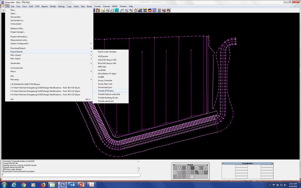
1 Landfill Grading Using GPS Machine Control NC SWANA April 2018 Presented by: Bernie Garrett, PE Garrett & Moore Inc. & Gabe Leach Cooper Barnette & Page Inc. 1
2 Purpose Work flow processes used by Engineers, Surveyors, and Contractors to construct landfill base grades using GPS Machine Control Technology 2
3 Background Global Positioning Systems (GPS) have evolved in recent years to the point where reliability and accuracy of GPS is utilized to control construction equipment used for grading CADD programs utilized by Engineers have capabilities to efficiently develop 3-D models of grading plans. 3
4 Engineer: Autodesk: Civil 3D Bentley: Microstation Trimble: Terramodel Software Programs Surveyor: Trimble: Trimble Business Center Hexagon Geosystems: LEICA Geosystems Topcon Positioning Systems: Geo-positioning Module Autodesk: Civil 3D/Trimble Link Contractor Trimble: Trimble Business Center Hexagon Geosystems: LEICA Machine Control Topcon Positioning Systems: Machine Control Module 4
5 Work Flow Engineering Design Permit Drawings: Prepared for the full build-out of a Landfill Approved by a Regulatory Agency Grading plans are lines on paper Construction Drawings: Depict a phase of landfill construction; not the entire landfill. Incorporate phase specific features, such as erosion control measures, interim anchor trench/berm, and interim access roads. 5
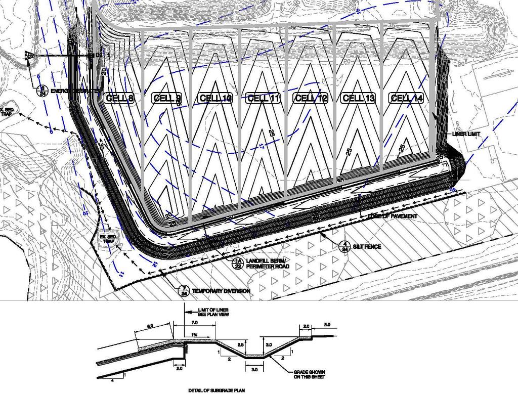
6 6
7 7
8 8

9 9
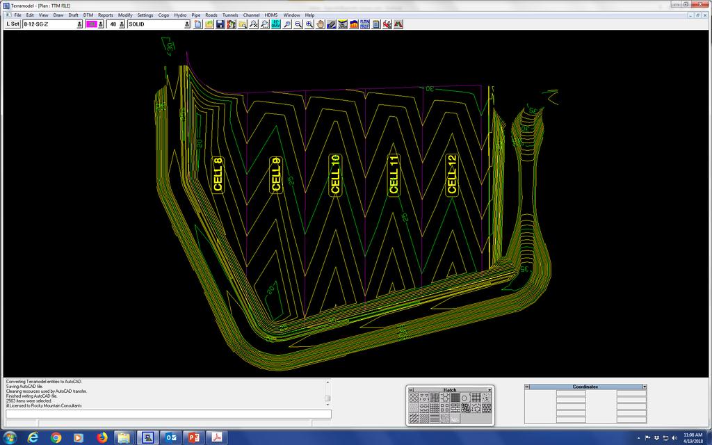
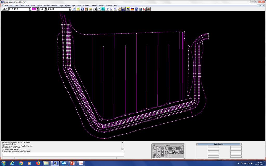
10 Work Flow with Contours as Engineer s Grading Plan Data Engineer Contractor Surveyor Exports Contours in.dwg format Contours in.dwg format Contours in.dwg format QC/Approval of 3-D Model versus Engineer s Contours Checks 3-D Model versus Engineer s Contours Builds a 3-D Model in a Trimble format Creates a Trimble file (.ttm) Loads.ttm file into Operators Computer 10
11 11
12 Work Flow with 3-D Model as Engineer s Grading Plan Data Engineer Contractor Surveyor Creates a Trimble file (.ttm) Checks.ttm file versus Engineer s Contours Loads.ttm file into Operators Computer 12
13 Work Flow Contractor Coordination with Surveyor: Surveyor establishes and accurately measures a network of Control Points that surround the limits of work. Collected data is post processed and sent to contractor. 13

14 Surveyed Control Points 14


15 Site Calibration A Base Station is installed on the job site and calibrated based on the data collected from surveyor. -Site Calibration is required to define a relationship between global and local coordinate systems. -Precision of the calibration is crucial as it will directly relate to the projects overall accuracy. 15
16 CAD Data Import Office Data Prep CAD data from the design engineer is imported and organized according to scope of work. All CAD data is compared to the official Construction Drawings. Once the CAD files are verified Digital Terrain Models are built to represent the Construction Drawings. 16


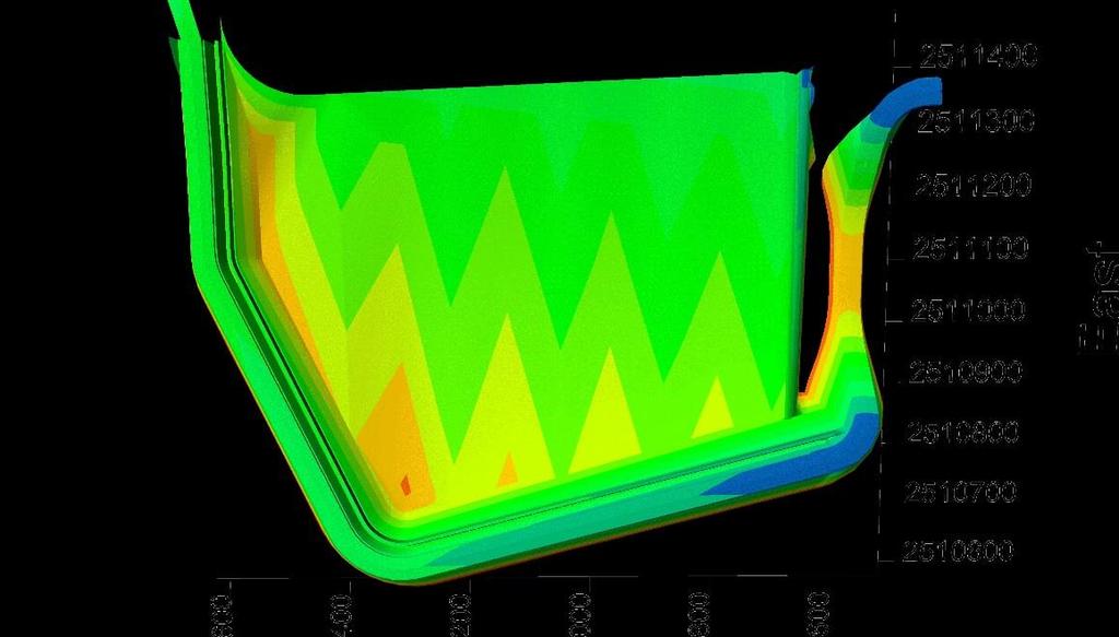
17 3D Surface Model -Once complete, the surface is reviewed in 3D space. -After confirmation that the surface is error free and conforms to the Official Construction Drawings the files are exported for use in the field. 17

18 Field QA/QC Checks -Dozer and Excavators are measured for blade or bucket wear and verified accurate before and during the project. -Benchmarks are installed on-site and operators check elevations on them daily before beginning work. -Small test pad graded to a known elevation for certifying surveyor to check. This will insure our equipment is set up accurately and the grades we provide will meet the certification plan. 18

19 Machine Control Once imported to the machines control box the operator can see exactly where he is on the project and how much cut or fill is required. 19
20 Why Do We Use Machine Control? Gives us a technical edge over our competitors. Saves time and resources on the job. Decreased stakeout work by up to 90% Eliminates reworked areas to meet certification grades. Increase productivity Decreased material handling and material waste. Decreases operator fatigue. Increased accuracy. Grades can be met the first time accurately and efficiently. 20


21 Grade Control Equipped Excavator 21


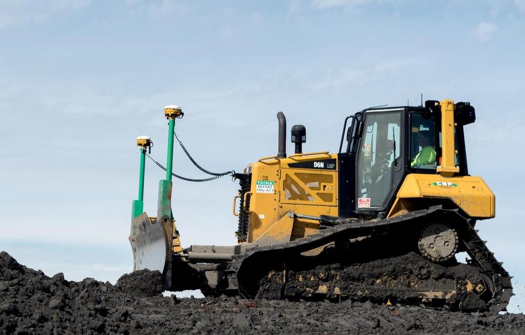
22 Grade Control Equipped Dozer 22
23 Technical Abilities Required for GPS Manager High level computer skills for managing and organizing multiple file types over multiple job sites. Proficiency with AutoCAD software. Take-Offs for bids. Surface creation and export once job is awarded. Assist with material quantity updates for production studies throughout the job. Solid understanding of heavy construction equipment and practices. 23
24 Technical Abilities Required for GPS Manager Basic knowledge of Survey principals for Site Calibration, Topos, and Stakeouts as needed. Extensive knowledge of GPS components installed on machines for maintenance, repair, and operator training. 24
25 Summary Landfill Owners Be certain that your Engineer, Surveyor, and Contractor are all utilizing the best technology available. 25
3-D MODELING FOR MACHINE CONTROL
 SHELLY & SANDS JOHN DOWALTER, PE, PS 3-D MODELING FOR MACHINE CONTROL Dale Carnegie Public Speaking Training Ben Stein s Public Speaking Training SHELLY & SANDS JOHN DOWALTER, PE, PS S&S Survey Manager
Continuously Operating GPS Reference Network. Jim Waters, PE, RLS Assistant Director, Design Division
 Continuously Operating GPS Reference Network Jim Waters, PE, RLS Assistant Director, Design Division TDOT began discussions internally about a possible Continuously Operating Reference Network in 1999
Table of Contents. Note to Self-Paced Users of the Day 2 Seminar Handbook. Notices 1. Quick Reference 2. Seminar Outline 14
 Table of Contents Note to Self-Paced Users of the Day 2 Seminar Handbook i Notices 1 Quick Reference 2 Seminar Outline 14 Program and Vector Data Overview 17 A Toolbox for Creating Earthwork Models 17
TRIMBLE GEOMATICS OFFICE TECHNICAL NOTES
 The Trimble Geomatics Office software is an important part of Trimble s total surveying solutions. Never has the collection, processing, and management of survey data been so easy. Surveyors and engineers
3-D Modeling Implementation
 3-D Modeling Implementation Presented January 31, 2013 Douglas Townes FHWA Resource Center WORKFLOW FOR ELECTRONIC DATA TRANSFER WHEN USING AMG IN CONSTRUCTION Charles Jahren, PhD Iowa State University
Integrated Field to Finish BIM for Surveyors. Boris Skopljak Market Manager, Trimble Geospatial Office Software
 Integrated Field to Finish BIM for Surveyors Boris Skopljak (boris_skopljak@trimble.com) Market Manager, Trimble Geospatial Office Software Agenda Trimble Introduction BIM relevance in Trimble Trimble
TechnicalNotes. Trimble Geomatics Office Software
 TechnicalNotes Trimble Geomatics Office Software AT LAST A SINGLE SOFTWARE PACKAGE TO HANDLE ALL OF YOUR SURVEY DATA The Trimble Geomatics Office software is a key component in the Trimble Toolbox of Integrated
Figure 1: Mobile mapping project location in New York City.
 Using Mobile LiDAR to Deliver Survey Accurate Data This presentation will take the attendees though the process of controlling and delivering survey grade LiDAR data for use in CADD, Modeling, and GIS
Box Calibration: Here I entered points 3 and 4 which are the only control points given to us in the plans.
 Box Calibration: Trimble machine control does not like files that are derived from State Plane Coordinates or files that contain a Geoid. Trimble representatives want everyone to do a site calibration
Trimble Grade Control Systems GCS900 2D for Dozers
 GCS900 2D for Dozers Trimble offers the heavy and highway contractor the broadest range of Grade Control Systems in the industry. From 2D depth, slope, and elevation based to 3D GNSS or Total Station based,
Which Trimble Grade Control System for which application?
 September 2005 Which Trimble Grade Control System for which application? The following outlines the ideal and typical applications for each of the Trimble Grade Control Systems. The information has been
A 3D Scanner Based Technology for Land Levelling
 A 3D Scanner Based Technology for Land Levelling Kunal Chakraborti, Rupam Ghosh Student, Dept of Civil Engineering, Modern Institute of Engineering & Technology, Bandel, Hooghly, West Bengal, India ABSTRACT:
Features and Benefits
 CAiCE Visual Survey 10 Features and Benefits CAiCE Visual Survey 10 software enables surveying professionals to import, process, analyze, and present surveying all in one software package. Visual Survey
TECHNOLOGY SOLUTIONS TRANSFORMING CONSTRUCTION LAYOUT. Trimble Field Link TRANSFORMING THE WAY THE WORLD WORKS
 TECHNOLOGY SOLUTIONS TRANSFORMING CONSTRUCTION LAYOUT Taking full advantage of the Trimble Tablet s processor and multi-touch screen functionality, has been designed to work the way you work. Featuring
MODERN TECHNOLOGY FOR LAND LEVELLING, BASED ON A 3D SCANNER
 MODERN TECHNOLOGY FOR LAND LEVELLING, BASED ON A 3D SCANNER Abstract: Soil levelling becomes of high importance, in modern and intensive agriculture conditions. Its effects are found in providing optimal
Technical training May - August
 2017 Technical training May - August Register today! theppigroup.com/training Training centers located in Portland, OR & Seattle, WA. Why Train with PPI? PPI is the only locally owned and operated Autodesk
A KHL SPECIAL REPORT SURVEYING
 A KHL SPECIAL REPORT SURVEYING 3 YEARS OF REPORTS FROM CONSTRUCTION EUROPE CONSTRUCTION Rugged and efficient A range of new hardware and software in the surveying sector has been designed to improve efficiency,
Presentation Overview
 Stringless Concrete Paving STRINGLESS CONCRETE PAVING ACPA BUS TOUR AUGUST 5, 2015 Presentation Overview 1) Manufactures 2) Components needed for Stringless Paving 3) Conventional Methods VS Stringless
Trimble SCS900 Site Controller Software for Beginners. Jordan Lawver HCC-6339
 Trimble SCS900 Site Controller Software for Beginners Jordan Lawver HCC-6339 Agenda What is Trimble SCS900 Site Controller Software? Who uses SCS900 Trimble Site Positioning System software portfolio Applications
Guideline for Importing Survey Data into Bentley Power InRoads v8i SS2
 Guideline for Importing Survey Data into Bentley Power InRoads v8i SS2 I. REQUIREMENTS from the Geomatics/Survey Function: 1. A CAD-only drawing in.dwg file format ver. 2013, (that can be created natively
ENHANCED DELIVERABLES AND THE DIGITAL JOBSITE NOVEMBER 14, 2018
 ENHANCED DELIVERABLES AND THE DIGITAL JOBSITE NOVEMBER 14, 2018 Background CP Tech Center/Snyder & Associates team EDC-2 3D Engineered Models EDC-4 e-construction (Digital Construction Inspection) 2 What
Trimble Grade Control Systems GCS900 2D for Excavators
 GCS900 2D for Excavators Trimble offers the heavy and highway contractor the broadest range of Grade Control Systems in the industry. From 2D depth, slope, and elevation based to 3D GNSS or Total Station
Protect by Leica Geosystems A Lifetime Guarantee
 Protect by Leica Geosystems A Lifetime Guarantee Protect by Leica Geosystems We always protect your success PROTECT by Leica Geosystems Lifetime Warranty No Cost Period Certified Quality Swiss Technology
Mn/DOT CADD DATA Standards General Information
 Mn/DOT CADD DATA Standards General Information PREFACE The scope of this web-site is to document and standardize the Minnesota Department of Transportation s CADD (computer aided drafting and design file
Migrating from Autodesk Land Desktop to Autodesk Civil 3D CV42-3L
 December 2-5, 2003 MGM Grand Hotel Las Vegas Migrating from Autodesk Land Desktop to Autodesk Civil 3D CV42-3L About the Speaker: Pete Kelsey is an Autodesk Authorized Consultant an Autodesk Certified
Business Advantages of Using Electronic Engineering Data
 Business Advantages of Using Electronic Engineering Data Dan Streett, PE & LS NYS Department of Transportation December 5, 2006 AGC/DOT Technical Conference Types of Electronic Engineering Data Created
12d Model v8 interface to Trimble instruments 2007
 These notes describe the interfacing of 12d version 8 with the Trimble surveying instruments. 1) Installing Trimble link Trimble link must be installed prior to attempting to upload or download data to
TRIMBLE ACCESS HELP SHEETS Using Map Functions
 1 of 5 SUPPORTED MAP FEATURES This section will guide the user through some Trimble Access Map funtions including: Importing surfaces, Alignments,.shp files,.dxf files; creating surfaces, creating lines
Pave the Way to Better Profits. Trimble. Paving Solutions TRANSFORMING THE WAY THE WORLD WORKS
 Pave the Way to Better Profits Trimble Paving Solutions TRANSFORMING THE WAY THE WORLD WORKS Solutions for the Complete Paving Job Site Productive, integrated and innovative solutions to keep you on track
Trimble s RoadLink Utility Tutorials
 Trimble s RoadLink utility is an interface between third-party road definitions and Trimble survey devices. It lets you import or key in road definitions, view them graphically, edit them if required,
Leica icon grade Intelligent grading solutions
 Leica icon grade Intelligent grading solutions intelligent CONstruction leica-geosystems.com Leica icon grade igd2 and igd3 Complete 2D and 3D solutions for all large earth moving projects igd2, icon grade
RELEASE NOTES TRIMBLE REALWORKS SOFTWARE VERSION System requirements New Features and Changes
 RELEASE NOTES TRIMBLE REALWORKS SOFTWARE VERSION 9.0.1.313 System requirements New Features and Changes Trimble Navigation Ltd, 10368 Westmoor Drive, Westminster, CO 80021, USA 2014, Trimble Navigation
icon office release of version
 Product: icon office Date: 17.12.2019 From: Torgny Israelsson icon office release of version 2019.1.11.20 We are pleased to announce the release of icon office 2019. icon office is now available as 64-bit
Accuracy of a Machine Guided Grader
 University of Southern Queensland Faculty of Health, Engineering and Sciences Accuracy of a Machine Guided Grader A Dissertation submitted by Mitchell Bell In fulfilment of the requirements of ENG4111
Civil 3D Interoperability with Revit: Part I
 April, 2012 Civil 3D Interoperability with Revit: Part I BIM in Architecture and Engineering The basis behind using Building Information Modeling is that all objects are 3 dimensional: models are all able
James Schneider Advanced Materials and Technology
 (CEC-90153) Minnesota DOT Deploy GCS900, Business Center HCE and VisionLink with the DOTs GEOPAK software to automatically monitor large scale excavation in Carver County James Schneider Advanced Materials
The Magic of a Dynamic Differential TIN Surface
 The Magic of a Dynamic Differential TIN Surface Creg Dieziger Sr. Designer, Morrison-Maierle, Inc. CI3906 Ever wish that AutoCAD Civil 3D could create a dynamically linked subgrade surface, while you build
SURVEY 3.0. Innovative field solutions for Surveyors X PAD. works when you do
 Innovative field solutions for Surveyors works when you do X PAD INNOVATIVE FIELD SOLUTION FOR SURVEYORS The software for survey, stakeout and control, ensuring productivity and flexibility in the field,
TRIMBLE WESTMINSTER BUILDING PROJECT / 2013
 TRIMBLE WESTMINSTER BUILDING PROJECT - 2012 / 2013 OVERVIEW Outgrowing its current office facility in Westminster, Colorado, Trimble decided to build a larger campus across the street from their current
Linus L. Smith, GIS Supervisor, Engineering Public Works Department, City of Winfield, Kansas
 Challenges in Developing a City GIS Wastewater Geo Database System Linus L. Smith, GIS Supervisor, Engineering Public Works Department, City of Winfield, Kansas OVERVIEW The City of Winfield Kansas recognized
X-PAD Ultimate. The Ultimate solution in the field. Works when you do
 Works when you do X-PAD Ultimate The Ultimate solution in the field X-PAD Ultimate is a tailored, flexible, modular, ideal, customised software for high end topographic tasks, such as measure, stake-out,
REFERENCE. Section 9. Appendix 2-1
 REFERENCE Section 9 Appendix 2-1 REFERENCE 2-2 Using Auto Save The Auto Save feature automatically saves your job to ensure data is not lost during an inadvertent termination of Sitework 4D. To edit the
2015 HDR, all rights reserved.
 2015 HDR, all rights reserved. An Alternative to HEC-GEORAS: Overview & Comparison of AutoCAD River & Flood Analysis Module Ron Branyon, PE, CFM George Doubleday, EIT, CFM Brandon Hilbrich, PE, CFM TFMA
This document contains a list of all changes, new features, bug fixed introduced in this last version of X PAD Survey.
 News X PAD Survey - January 2014 X PAD Survey 2.5.5 This document contains a list of all changes, new features, bug fixed introduced in this last version of X PAD Survey. GPS X-Y RSM: X and Y RMS accuracy
Trimble Grade Control Systems GCS900 2D for Excavators
 GCS900 2D for Excavators Trimble offers the heavy and highway contractor the broadest range of Grade Control in the industry. From 2D depth, slope, and elevation-based to 3D GNSS or Total Station-based,
MoDOT s 3D Design Implementation, Electronic Deliverables, and E-Construction. Ashley Buechter, P.E. MoDOT CADD Support Engineer
 MoDOT s 3D Design Implementation, Electronic Deliverables, and E-Construction Ashley Buechter, P.E. MoDOT CADD Support Engineer LADOTD Transportation Conference February 29, 2016 General Information and
Grade Control. GRADE CONTROL SYSTEMS Topcon. MOTOR GRADER 3D-GPS+, mmgps Plug-and-Play. HYDRAULIC EXCAVATOR X63 3D-GPS+ Plug-and-Play
 GRADE CONTROL SYSTEMS Topcon Grade Control CRAWLER DOZER 3D-MC 2 Plug-and-Play HYDRAULIC EXCAVATOR X63 3D-GPS+ Plug-and-Play MOTOR GRADER 3D-GPS+, mmgps Plug-and-Play PHOTOS MAY INCLUDE OPTIONAL EQUIPMENT
Revit MEP 2014 Add-in. SysQue
 Revit MEP 2014 Add-in the difference is REAL SysQue June 17, 2013-14:15 Managed manufacturer specific objects and data in BIM Jim Reis, CFO TSI JReis@TSI-Software.com TSI Overview: What We Do the difference
GCS900 GRADE CONTROL SySTEmS LK Bu RADE G FINISH
 GCS900 GRADE CONTROL Systems BulK Grade take the guesswork out of earthworks Trimble sets the standard for construction technology by developing highly productive, integrated and innovative solutions for
WHY TRAIN WITH PPI? YOUR TECHNICAL HOME TEAM. CALL US TO LEARN MORE ABOUT GLOBAL E-TRAININGäS LIBRARY
 WHY TRAIN WITH PPI? PPI is the only locally owned and operated Autodesk reseller in Oregon and Western Washington! We have the largest Autodesk training centers in the Northwest! GLOBAL E-TRAINING IS THE
The foundation of BIM for structural engineering. Autodesk Revit. Structure 2010
 The foundation of BIM for structural engineering. Autodesk Revit Structure 2010 Building Information Modeling for Structural Engineering Integrated tools for modeling, coordination, analysis, design documentation,
Civil 3D Technology Certificate Program
 Civil 3D Technology Certificate Program Program Description 216 Course Hours of Instruction Program Completion Time 9 Months Upon Completion VDCI Professional Technology Certificate Awarded Civil 3D In
GIS Mapping of Pipelines
 GIS Mapping of Pipelines RJ Lumbrezer, PS Survey Manager DGL Consulting Engineers, LLC Ted Muns Sales Manager City Blueprint of Toledo 2016 Ohio GIS Conference Hyatt Regency Columbus September 28 30, 2016
Session Objectives. Describe how 3D Models are created during design. Discuss what 3D Model outputs are useful in Construction
 1 Session Objectives Describe how 3D Models are created during design Discuss what 3D Model outputs are useful in Construction Describe applications of 3D Models in Construction 2 Creating the 3D Design
2009 IHEEP CONFERENCE The Future of CORS Networks and AMG
 2009 IHEEP CONFERENCE The Future of CORS Networks and AMG Background Dominick Izzo, PE Lancaster Development, Inc. Heavy Highway Contractor in Upstate NY Member of NYSAGC/NYSDOT Emerging Technology Committee
Trimble Productivity: Finish Faster with Fewer Machines. GCS600 Grade Control System
 Trimble Productivity: Finish Faster with Fewer Machines GCS600 Grade Control System for Excavators Flexible, Affordable and Easy to Use Productivity and Payback in One Package: Looking for a flexible,
Trimble Grade Control Systems GCS900 2D for Motor Graders
 GCS900 2D for Motor Graders Trimble offers the heavy and highway contractor the broadest range of Grade Control Systems in the industry. From 2D laser or sonic based to 3D GNSS or Total Station based,
NC SWANA Managers Training Center
 NC SWANA Managers Training Center Hotel Ballast Wilmington 301 N. Water Street Wilmington, NC 28401 (910) 763-5900 June 11-14, 2018 In cooperation with National SWANA; NC-SWANA is holding it s Annual Chapter
Leica High-Definition Surveying Systems. Leica HDS3000. The Industry Standard for High-Definition Surveying
 Leica High-Definition Surveying Systems Leica HDS3000 The Industry Standard for High-Definition Surveying HDS High-Definition Surveying TM : Laser Scanning Redefined High-Definition Surveying, or HDS,
The Leica HDS Family. The Right Tool for the Job HDS3000 HDS2500 HDS4500. Cyclone & CloudWorx. Press the QuickScan button to define the field-of-view.
 HDS2500 High accuracy scanner, ideal for fixed or raised installations when leveled tripod mounting is not practical, or areas with less stringent field-of-view requirements. The Leica HDS Family Time-of-flight
COLLABORATION is KEY
 AN AERIAL ADVANTAGE COLLABORATION is KEY LIVING AND WORKING IN A WORLD OF FAST TECHNOLOGICAL ADVANCEMENT, COLLABORATION OF SKILLS IS BECOMING MORE COMMONPLACE. DTM Technologies Ltd and Seahawk AP have
3D Technology in the Construction Continuum. Alabama DOT Pre-Construction Conference Montgomery AL May 03, 2016
 3D Technology in the Construction Continuum Alabama DOT Pre-Construction Conference Montgomery AL May 03, 2016 Brian E Girouard, Sales Engineer, Milling-Paving-Compaction Specialist Civil Engineering &
Autodesk Revit. Structure
 The power of BIM for structural engineering. Autodesk Revit S L N E TW R K Structure Improve Efficiency, Accuracy, and Coordination Concurrent modeling for structural design, analysis, and coordinated
Draper Aden VIRTUAL CONSTRUCTION DOCUMENT, DESIGN, AND BUILD IN 3D
 VIRTUAL CONSTRUCTION VIRTUAL CONSTRUCTION The design and construction environment has changed. While the goals of completing a project on time, within budget, and at the expected level of quality remain
Trimble GCSFlex Grade Control System For Excavators
 The Trimble GCSFlex Grade Control System is an easy-to-use, reliable, and affordable machine control system to improve excavator productivity and be more competitive. The system provides real-time grade
Company Profile. Language independence for the entire system, which has been recently implemented, makes the software suitable for global deployment.
 Company Profile Barthauer Software GmbH is a mediumsized company that has been operating in the German-speaking regions of Europe for over 25 years. More than 1,700 customers are now using Barthauer software.
Texas Transportation Institute The Texas A&M University System College Station, Texas
 1. Report No. FHWA/TX-08/5-2110-01-4 4. Title and Subtitle INVENTORY OF UTILITIES SUMMARY REPORT 2. Government Accession No. 3. Recipient's Catalog No. Technical Report Documentation Page 5. Report Date
Leica icon grade Intelligent grading systems NEW. igd4 SP System. i n telligent COnstruction
 Leica icon grade Intelligent grading systems NEW igd4 SP System i n telligent COnstruction Leica icon grade Maximize productivity, speed & flexibility The Leica icon grade solutions can revolutionize your
AutoCAD Civil 3D 2014 for Surveyors
 AutoCAD Civil 3D 2014 for Surveyors SDC P U B L I C AT I O N S Better Textbooks. Lower Prices. www.sdcpublications.com Powered by TCPDF (www.tcpdf.org) Visit the following websites to learn more about
Autodesk Civil 3D Fundamentals
 Autodesk Civil 3D Fundamentals Course Length: 4 days The Autodesk Civil 3D Fundamentals training course is designed for Civil Engineers and Surveyors who want to take advantage of the Autodesk Civil 3D
REFERENCE. Section 6. Field Use Tutorial 2-1
 REFERENCE Section 6 Field Use Tutorial 2-1 REFERENCE 2-2 Field Use Overview RTK GPS support is an additional feature in Sitework 4D, which must be purchased separately. In addition to creating takeoffs
Trimble Certified Trainer Guide
 July 2012 Trimble Certified Trainer Guide The following guide is to assist Trimble Certified Trainers with various aspects of their certification requirements. Information includes: Bookmark Links Pages
OPEN. INTELLIGENT. Laser Scanning Software Solutions
 OPEN. INTELLIGENT. Laser Scanning Software Solutions www.lfm-software.com The Future of Laser Scanning Safe and efficient operation of complex engineering assets, and the efficient management of their
Microwave. Infrared. Preprogrammed Chip
 Advanced Technology for Design Mapping and Construction Layout AACE A.A.C.E. Meeting August 5, 2009 Daniel K. Mardock RBF Consulting Survey Manager Registered Land Surveyor Certified Federal Surveyor Arizona
The power of BIM for structural engineering. Autodesk Revit. Structure
 The power of BIM for structural engineering. Autodesk Revit Structure Improve Efficiency, Accuracy, and Coordination Concurrent modeling for structural design, analysis, and coordinated documentation Building
Trimble Realworks Software
 TECHNICAL NOTES Trimble Realworks Software A Powerful 3D Laser Scanning Office Software Suite DESIGNED FOR TODAY S MULTIFACETED SCANNING PROFESSIONAL, TRIMBLE REALWORKS IS A POWERFUL OFFICE SOFTWARE THAT
technical notes Trimble survey controller field software
 Trimble survey controller field software technical notes For more than a decade, Trimble Survey Controller field software has provided land surveyors with a complete GNSS and optical data-collection solution
Field to Finish and the New Survey Tools in AutoCAD Civil 3D 2013
 Field to Finish Using AutoCAD Civil 3D Field to Finish and the New Survey Tools in AutoCAD Civil 3D 2013 Shawn Herring, Sr. Civil Application Engineer/Support & Training Manager Jason Jenkins, PLS Civil
Design Manual METROPOLITAN W ASHINGTON AIRPORTS A UTHORITY
 WELCOME The Design Manual documents are official and formal publications of the Metropolitan Washington Airports Authority. The primary Design Manual documents are viewed by Acrobat *.pdf files on the
connecting your construction site
 TRIMBLE: Connecting Your Construction SitE connecting your construction site The Ultimate Data Management System Business Center Heavy Construction Edition (HCE) from Trimble is the only office software
Machine control/landxml Anvendelse af 3D design i udførelsesfase (the use of 3D design in the construction phase)
") Anvendelse af 3D design i udførelsesfase (the use of 3D design in the construction phase) V/ Michael Jepsen Project Manager/CAD Engineer Road & Railway department Grontmij - Carl Bro Denmark Danish Civil
Anvendelse af 3D design i udførelsesfase (the use of 3D design in the construction phase) V/ Michael Jepsen Project Manager/CAD Engineer Road & Railway department Grontmij - Carl Bro Denmark Danish Civil
TECHNICAL NOTES TRIMBLE SURVEY CONTROLLER SOFTWARE
 TRIMBLE SURVEY CONTROLLER SOFTWARE TECHNICAL NOTES The Trimble Survey Controller software is the data collection solution that will make your survey work faster, easier, and more productive than ever before.
A Sweet Success in Plant Documentation for Michigan Sugar Company
 A Sweet Success in Plant Documentation for Michigan Sugar Company COMPANY LOCATION 3D Imaging Services Flint, MI TOOLS USED Leica ScanStation P40 (solutionshardware-p40.html) Leica Cyclone Software (solutionssoftware-cyclone.html)
Working with Profiles
 Tennessee Association of Professional Land Surveyors 2016 Annual Conference Murfreesboro Working with Profiles In Carlson Software Presented by Who Is That CAD Girl? Jennifer DiBona is a long time CAD
Realworks Software. A Powerful 3D Laser Scanning Office Software Suite
 TECHNICAL NOTES Realworks Software A Powerful 3D Laser Scanning Office Software Suite Trimble RealWorks is a powerful office software that imports rich data from your 3D laser scanning instrument and transforms
Trimble Site EASY-TO-USE RELIABLE ACCURATE
 Trimble Site Positioning Systems ACCURATE RELIABLE EASY-TO-USE more tools for more jobs Estimators Bid Team Site Surveyor Data Manager Site Engineer/Grade Checker Site Foreman/Supervisor Project Manager
Trimble Productivity: Finish Faster with Fewer Machines. TRIMBLE GCS900 GRADE CONTROL SYSTEMS
 Trimble Productivity: Finish Faster with Fewer Machines. TRIMBLE GCS900 GRADE CONTROL SYSTEMS TAKE ThE GUESSWORK OUT OF EARThWORKS. ONLY FROM ThE LEADER. TRIMbLE. The Connected Construction Site An interesting
RealWorks Software. A Powerful 3D Laser Scanning Office Software Suite
 TECHNICAL NOTES RealWorks Software A Powerful 3D Laser Scanning Office Software Suite Trimble RealWorks is a powerful office software that imports rich data from your 3D laser scanning instrument and transforms
Digital Terrain Model V 6.5
 TCP MDT Digital Terrain Model V 6.5 Professional Version Introduction The Professional Version is designed to assist users in all the phases of carrying out a Surveying or Civil Engineering project. Its
Critical Essentials. Overview. Objectives. Recommended Prior Skills. Upon completion of these topics, you should be able to:
 Critical Essentials Visualizing spaces in three dimensions is critical to the success of the design of architectural spaces. The interplay of light, color, and space are critical concepts to master. Traditional
Autodesk Certification Exam Guide AutoCAD Civil 3D 2010
 Autodesk Certification Exam Guide AutoCAD Civil 3D 2010 Preparation Guide for AutoCAD Civil 3D 2010 Certified Associate and AutoCAD Civil 3D 2010 Certified Professional Certification Exams. This guide
Product Leica Infinity. Date Nov 30 th, From Kevin Hanson
 Product Leica Infinity Date Nov 30 th, 2017 From Kevin Hanson Leica Geosystems AG Heinrich-Wild-Strasse CH-9435 Heerbrugg Switzerland www.leica-geosystems.com Table of Contents 1 About this Release...
MANITOBA LANDFILL OPERATOR CERTIFICATION PROGRAM SUSTAINABLE DEVELOPMENT
 MANITOBA LANDFILL OPERATOR CERTIFICATION PROGRAM MANITOBA SUSTAINABLE DEVELOPMENT 2017 TABLE OF CONTENTS FOREWORD... 3 Landfill Operator Certification Program Overview... 4 DEFINITIONS... 5 1.0 PROGRAM
AutoCAD Civil 3D 2011 ESSENTIALS
 AutoCAD Civil 3D 2011 ESSENTIALS SDC PUBLICATIONS www.sdcpublications.com Schroff Development Corporation Table of Contents Table of Contents Preface...ix Module 1 The AutoCAD Civil 3D Interface... 1-1
Leica System 1200 Software Integrated Software for GPS1200 and TPS1200
 Leica System 1200 Software Integrated Software for GPS1200 and TPS1200 Leica System 1200 Software System 1200 software includes SmartWorx the onboard TPS, GPS and RX1250 software and the Leica Geo Office
Advanced Highway Maintenance and Construction Technology Research Center
 Advanced Highway Maintenance and Construction Technology Research Center Department of Mechanical and Aerospace Engineering University of California at Davis Creating Standards and Specifications for the
HYPACK HYPACK SURVEY DESIGN: HYPACK SURVEY: HYPACK EDITING: FINAL PRODUCTS: HYPACK HYPACK
 HYPACK HYPACK is one of the most widely used hydrographic surveying packages in the world, with over 3,000 users. It provides the surveyor with all of the tools needed to design their survey, collect data,
General GPS TPS ROB X POLE VOL RDN RPL Jobs management System settings (units, precision, parameters, etc.)
") XPAD Survey Modules XPAD Survey GPS TPS XPOLE General GPS TPS ROB XPOLE VOL RDN RPL Jobs management System settings (units, precision, parameters, etc.) Instruments GPS GPS TPS ROB XPOLE VOL RDN RPL Instrument
XPAD Survey Modules XPAD Survey GPS TPS XPOLE General GPS TPS ROB XPOLE VOL RDN RPL Jobs management System settings (units, precision, parameters, etc.) Instruments GPS GPS TPS ROB XPOLE VOL RDN RPL Instrument
Stringer Topo. For BricsCAD and AutoCAD. Getting Started
 Stringer Topo For BricsCAD and AutoCAD Getting Started Table of Contents Typical Surveyors Workflow - Stringer Topo for CAD... 1 Module 1 - Introduction to Stringer Topo for CAD... 2 Module 2: Introduction
LandXML.org 2.0. a Data Exchange Standard. for. Nathan Crews, Principal Schema Architect, LandXML.org
 LandXML.org 2.0 a Data Exchange Standard for eplan LandXML Deliverable Nathan Crews, Principal Schema Architect, LandXML.org Outline LandXML.org 1999 Autodesk supported effort LandXML Standard Adoption