Integrated Projects. Madonna di Pietranico Pompeii insula V1 V I S UA L COMPUTING L A B I ST I - C N R
|
|
|
- Shona Green
- 5 years ago
- Views:
Transcription
1 Integrated Projects Madonna di Pietranico Pompeii insula V1 V I S UA L COMPUTING L A B I ST I - C N R
2 La Madonna di Pietranico
3 Pietranico s Madonna Terracotta statue, destroyed by an earthquake. We used digital 3D technologies to create documentation and support the restoration. Many fragments, large incomplete areas, difficult to manipulate all the fragments, due to fragmentation and missing parts the statue could not stand on its own. 3D was used to plan the restoration and find problems, before committing to physical intervention

 photos, taken inside")
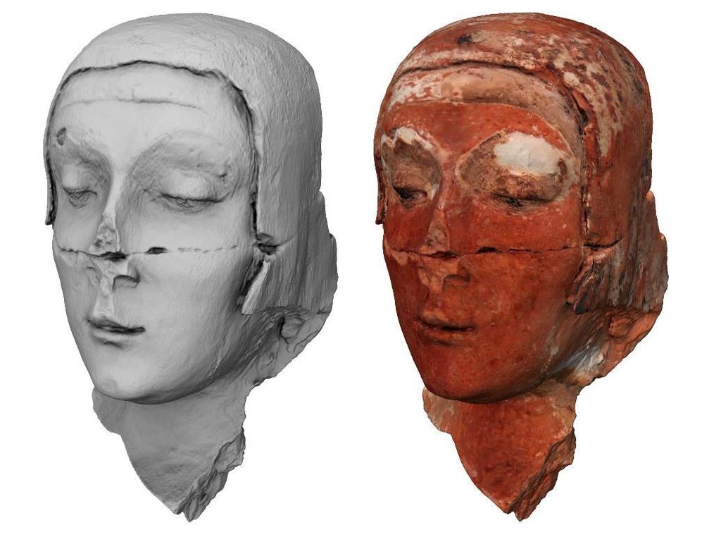
4 Pietranico s Madonna All fragments digitized with the Minolta Vi 910, color mapped from (calibrated) photos, taken inside a light-tent
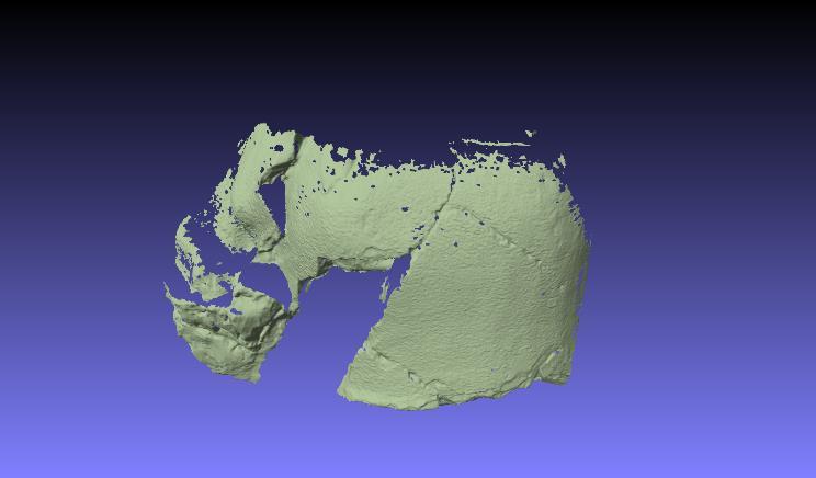
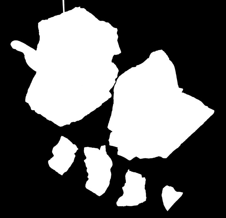
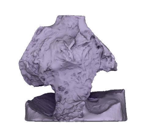
5 Pietranico s Madonna 27 fragments, from 15 to 60 scans each. 6GB of raw data. Not very complex pieces, but a lot of surface to cover. Target resolution around 0.5mm. «Master» 3D models from 1 to 6 millions triangles, then decimated to smaller resolutions for easier rendering and work. Models were already a precise metric documentation of the pre-restoration state.

6 Pietranico s Madonna
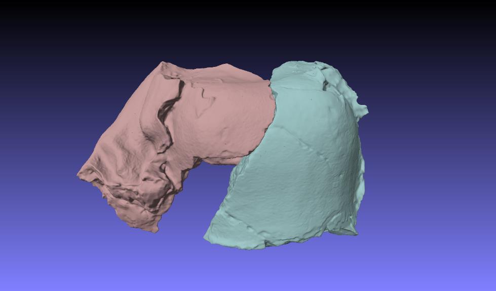
7 Pietranico s Madonna Digital reassembly: impossible to automatically compute fragment matching (non-clean break, small contact area). So we used a trick. We have model of part A and part B, restorers know relative position of parts A and B. We put them in the correct position, and do a single scan (AB_bridge). We then align 3D model A with the range scan AB_bridge, then we add 3D model B and align it to the same range scan AB_bridge. We remove range scan AB_bridge and the 3D models A ad B are in the correct position. We used more than 1 bridge for each couple (for a better rigidity) and we added ALL the fragments and bridges, doing a global align and optimization.
8 Pietranico s Madonna
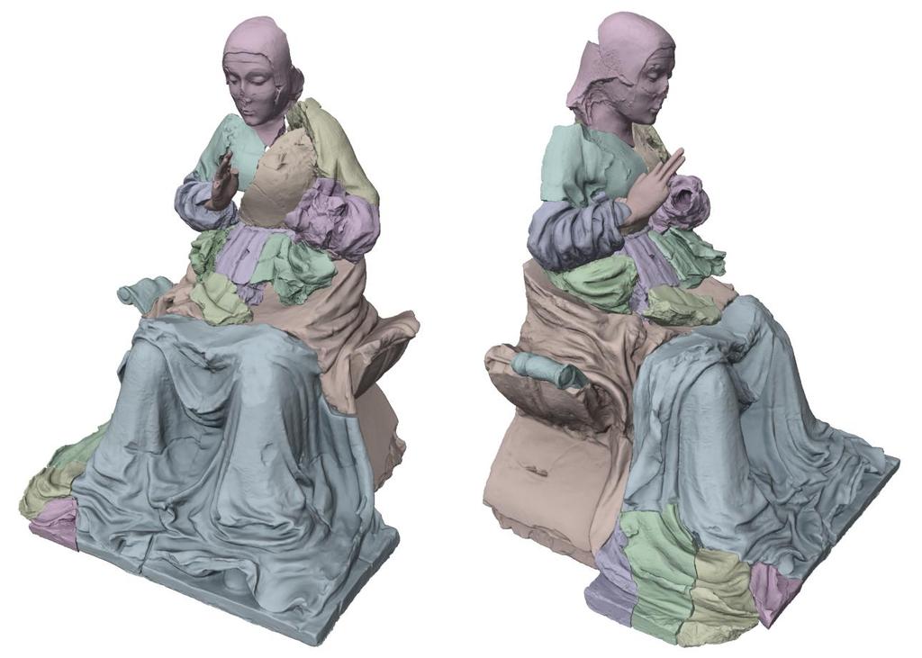
9 Pietranico s Madonna Worked very well, quick and effective. We also found a new contact point (impossible to find it on the physical object without assembly the whole statue). We had now a digital reassembly of the statue, useful to restorers to plan the intervention.

10 Pietranico s Madonna
11 Pietranico s Madonna The statue was BUILT in two parts. Due to its collapse and a previous (very old) restoration the correct relative position of top and bottom was lost. We tried, using the digital models, to recreate the original symmetry Relatove position based on symmetry of detail & handmade intervention, under the supervision of restorer and art historian.
12 Pietranico s Madonna
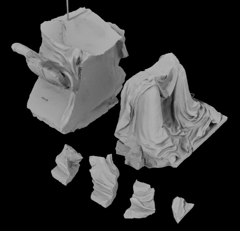
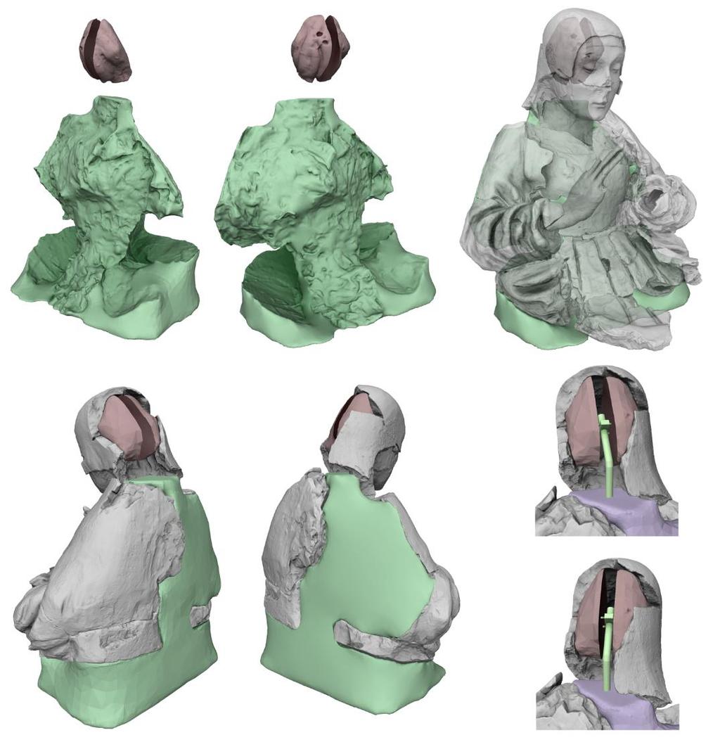
13 Pietranico s Madonna The fragments cannot stand on their own, due to missing parts and the fractures. How to support the fragments? The statue is hollow (from costruction) so we: - Selected all the fragment surfaces facing INSIDE the hollow. - Inverted the normals of these areas, and create a 3D model of the inside hollow (Poisson merging) The result is a 3D object that perfectly fits the inside volume - 3D-printed the result, and used it as a suport for the physical reconstruction
14 Pietranico s Madonna
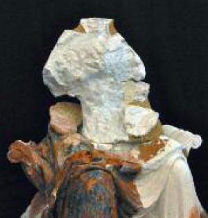
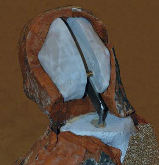
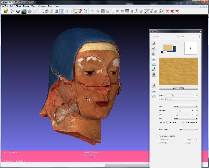
15 Pietranico s Madonna The head was made similarly, then splitted in 2, to allow insertion and have a screw to dilate the two halves to fix it Lot of manual editing (sculpting) to avoid small intersections between surfaces, and undercuts (which would prevent the physical assembly). It worked, but still required a lot of file-work when assembling (impossibel to comute the exact physical assembly constraints) As far as we know, it was the first time this technique has been used!
16 Pietranico s Madonna

17 Pietranico s Madonna They wanted to have an artist to recreate, still using terracotta, some missing parts, exploiting symmetry. We produced sections and orthographic views as templates.
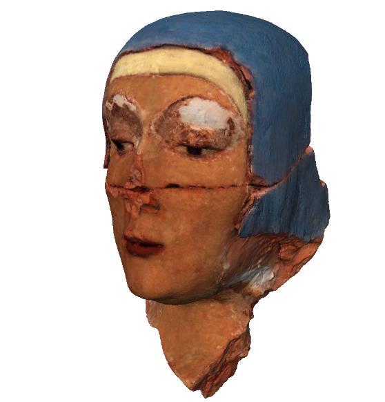
18 Pietranico s Madonna Color reconstruction: we tried, starting from historical documentation and the small residues of color, to reconstruct the original appearance. Remaining spots of the original color were photographed (calibrated photos), and the small areas used to synthesize larger textures, used for painting over the geometry. Just a hypothesis, still lot of data missing.
19 Pietranico s Madonna
20 Pietranico s Madonna Main publication, with all the details: Video:
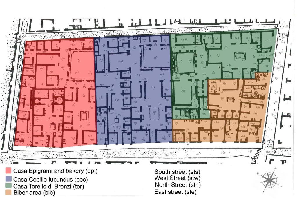
21 Pompeii insula V1
22 Collaboration with the Lund University (Sweden). Pompeii insulas (an insula is like a city block) are sometimes given "in external management" to foreign universities for study and documentation. We were involved int he 3D documentation of the two main houses of Insula V1, then we decided to do the entire insula
23
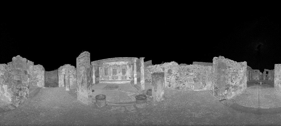
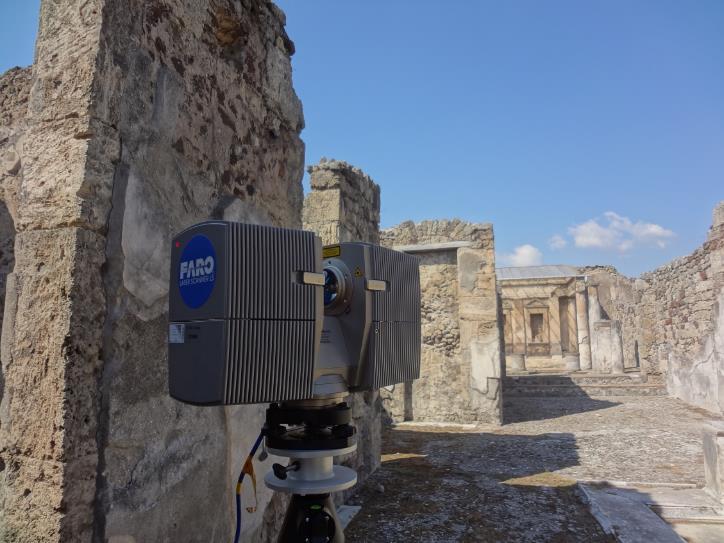
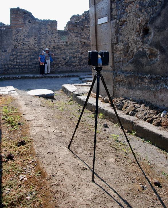
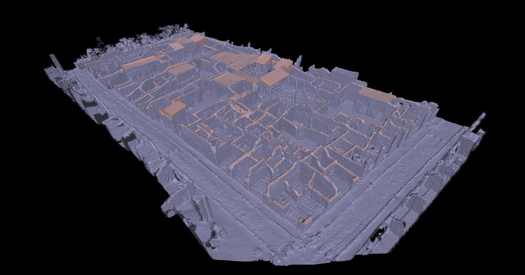
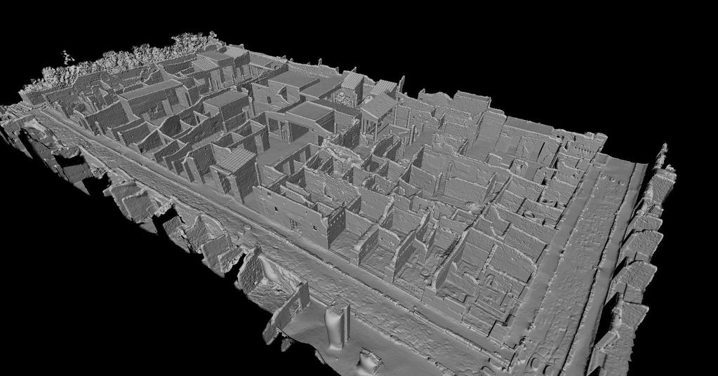
24 The insula is around 100x50 meters (without considering he roads) we covered ALL the rooms and areas, with a target resolution of 1cm. In many areas, we have a much higher res. 2 scanning team, with two similar devices (FARO Photon 120 and FARO Focus3D). 2.5 days scaning in the first year (to cover the two main houses), 3.5 days in the second year (to cover the rest). More than 310 scan used, all with 360 coverage
25
 and then put together using common areas between subparts.")
26 All scans subsampled at different resolutions (1cm, 2cm, 3cm) using Poisson-disk sampling. Alignment has been done in parts (each house or houses cluster, each street) and then put together using common areas between subparts. Alignment started on the 3cm dataset, then moved to 2cm and renfined, and then to 1cmm ad refined again. In this way we had less data at th begin, where most manual work was needed, and higher density later, when only automatic calculation was used.
27 All aligned scans merged using Screened Poisson, we used scans at 2cm resolution, the 1cm dataset would not fit in memory. The result was a 40+ millions triangles global model, covering the entre insula Full res scas were merged only on smaller areas (individual houses), to create additional "detail" models.

28 Scans merged using Screened Poisson


29 Some areas of the insula have been manually textured by the Lund university staff, and imported in their CAVE system, for immersive navigation
30 Reconstruction: Starting from the Cecilio Giocondo house 3D model, archeologists built a 3D reconstruction of the original state. The reconstruction is metrically correct, thanks to the 3D survey data. The 3D model was also useful because a lot of the traces of the missing structures are still visible in the walls, and the survey is accurate enough to make them visible (and measurable) Main publication available here: (most work done by Lund & Daniele Ferdani)


31
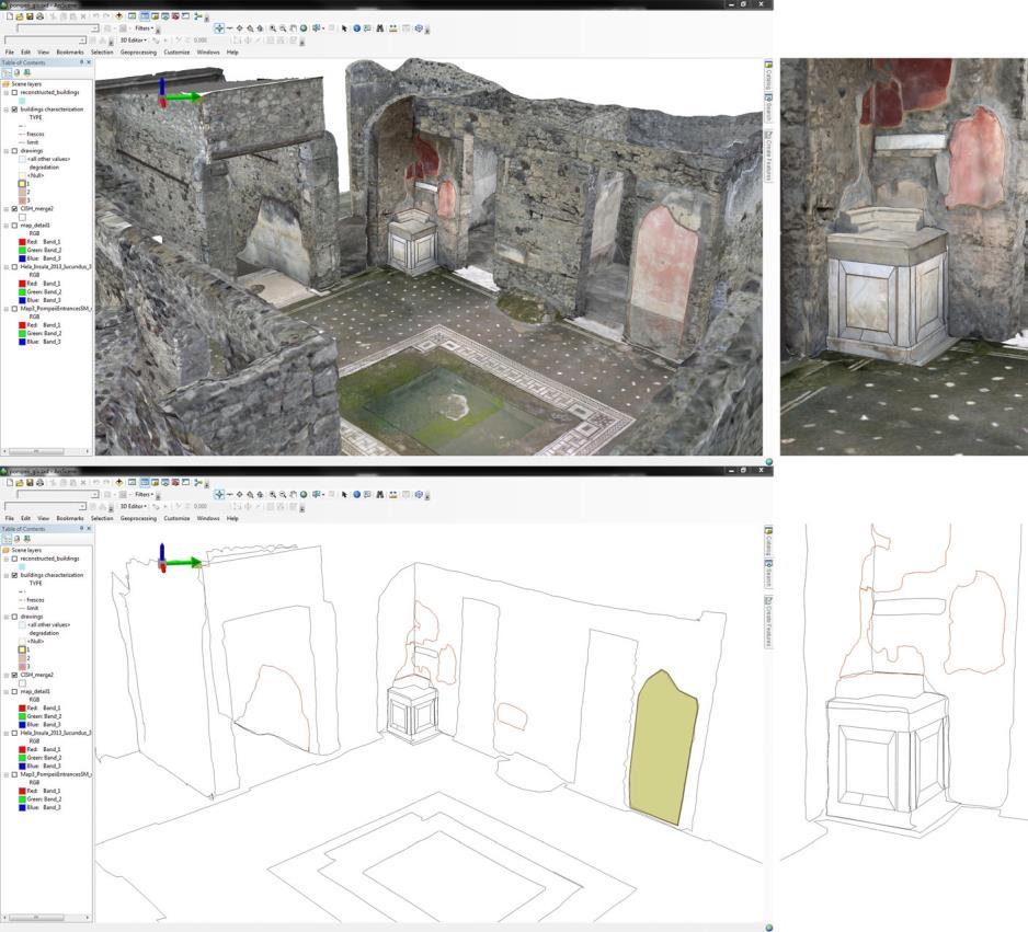
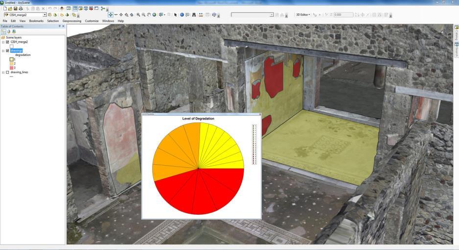
32 One of the most interesting aspect is the CONFIDENCE mappig and visualization Every part of he reconstruction is marked according to the kind of reasoning that was used to create that specific element (from direct evidence, from analogy, from pure deduction, from structural coherence ). This makes the reconstruction scientifically valid, and this color mapping may be used to communicate this information to the public

33
34 GIS: The 3D models have been georeferenced, and imported in GIS tools, with drawings, photos and other "classical" documentation. All thi georeferenced data is used for mapping problems and archeological annotations, to be able to do SPATIAL QUERIES Main publication available here: (most work done by Lund)

35


36 We are now working on ways to AUTOMATICALLY calculate geometric information (wall thickness, wall inclination, holes ) and other information taken from photoos (presence of moss, plaster, cracks) and transfer this values, mapped on surfacesm ti the GIS tool for more complex spatial queries
37 - Minimap with click-to-go feature - User position is shown using georeferenced coordinates - Switch from flyover view to first-person view (with wall collision) The viewer is re-usable for other similar terrain+buildings datasets, just changing the data

38 The viewer knows in which room is the user (only on the bottom aprt of the insula, it is still a work in progress), and can bring the user directly to the corresponding page on the swedish pompeii project website. The idea is a mixed navigation, 3D exploration, 2D map, room list.


39 The model is good for every area visible from ground BUT has no data for the upper part of taller walls and the roofs. We used the CNR drone to cover the upper parts 8 directional passes, with the camera facing the principal directions and with a 45 downward tilt, altitude of around 20 meters, following a regular serpentine path across the insula, taking a photo every few meters, in such a way that each photo has an overlap of around 40% with the adjacent ones. 1 panoramic pass, at a higher altitude (around 35 meters), following an elliptical path slightly larger than the insula, always facing towards the center of the insula. 714 photos at 18Mpixel
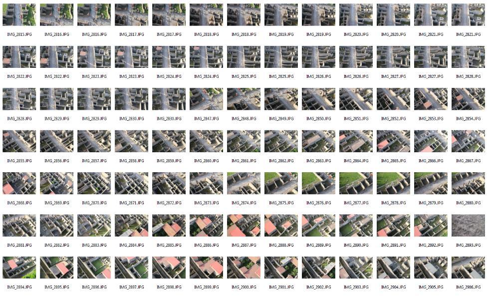
40
.")
41 The photos have been processed using PhotoScan, working in chunks (each chunk is made of two coverage direction, plus the global round) Chunks have then been merged in a single project using common photos (the global roud). The global roud has then been removed, to only keep photos with higher resolution on the buildings In total, used 581 photos, and obtained a 35 million points model All the processing (chunks, and final cloud generation) took some days (99% is pure calculation time).

42 This is the cloud coming from the drone photos, scaled and oriented with respect to the 3D scanned dataset. Pompeii Insula V1
43 Laser Scanner data is still denser and more precise, so we manually isolated from the Drone photos 3D model only the upper parts (and other areas of the surrounding streets). We did a new merging (again, with screened poisson), using the original scans (aligned and cleaned), and these new areas coming from the drone. In this way, the data is seamlessy merged, preserving the detail and ensuring maximum coverage.
44

45
46 We now have a complete 3D model of the insula with color (for most of the areas, the drone photos does not cover the inside of the rooms). We will put this in the viewer (and possibly finish it ) It is still an ongoing work, both for the online use + interactive exploration, and the automatic GIS data mapping + annotation.
47
Using high-res 3D: Digital Restoration
 Using high-res 3D: Digital Restoration MARCO CALLIERI [digital] Anastylosis / Restoration When working on digital 3D mdoels, there is often confusion between the two Digital anastylosis: Placement of digital
Grafica 3D per i beni culturali: Due esempi. Lezione 5: 9 Marzo 2011
 Grafica 3D per i beni culturali: Due esempi Lezione 5: 9 Marzo 2011 0 Example 1: Larger than life Portalada, monastery of Santa Maria De Ripoll, Spain 7 x 11 meters to be scanned at 1mm resolution Portalada
THE ETRUSCANS IN 3D: FROM SPACE TO UNDERGROUND
 THE ETRUSCANS IN 3D: FROM SPACE TO UNDERGROUND Fabio Remondino 1, Alessandro Rizzi 1, Belen Jimenez 1, Giorgio Agugiaro 1, Giorgio Baratti 1, Raffaele De Amicis 2 (1) 3D Optical Metrology (3DOM) Bruno
A COMPARISON OF SPARSE AND DENSE POINT APPROACH TO PHOTOGRAMMETRIC 3D MODELING FOR STONE TEXTURED OBJECTS (CASE STUDY: ARCHEOLOGICAL SITES) ABSTRACT
 ABSTRACT") A COMPARISON OF SPARSE AND DENSE POINT APPROACH TO PHOTOGRAMMETRIC 3D MODELING FOR STONE TEXTURED OBJECTS (CASE STUDY: ARCHEOLOGICAL SITES) Arnadi D. Murtiyoso 1, Deni Suwardhi 2 1,2 Spatial Information
A COMPARISON OF SPARSE AND DENSE POINT APPROACH TO PHOTOGRAMMETRIC 3D MODELING FOR STONE TEXTURED OBJECTS (CASE STUDY: ARCHEOLOGICAL SITES) Arnadi D. Murtiyoso 1, Deni Suwardhi 2 1,2 Spatial Information
Drones and Supercalculators : A New Field of Investigation in Photogrammetry.
 1 Drones and Supercalculators : A New Field of Investigation in Photogrammetry. The Rise in Popularity of Applications and Performances. Introduction... p. 2 Archeology... p. 3 National Heritage Sites
A New Protocol of CSI For The Royal Canadian Mounted Police
 A New Protocol of CSI For The Royal Canadian Mounted Police I. Introduction The Royal Canadian Mounted Police started using Unmanned Aerial Vehicles to help them with their work on collision and crime
A 130 Year- Old Story
 A 130 Year- Old Story The Architectural Survey of the Hungarian State Opera CÉH Inc. of Budapest, Hungary was tasked with the enormous task of measuring and modeling the Hungarian State Opera House. The
GUIDE TO POST-PROCESSING OF THE POINT CLOUD
 GUIDE TO POST-PROCESSING OF THE POINT CLOUD Contents Contents 3 Reconstructing the point cloud with MeshLab 16 Reconstructing the point cloud with CloudCompare 2 Reconstructing the point cloud with MeshLab
Mobile Mapping with the Road-Scanner in France Hi-grade 1:200 scale mapping
 FARO USER CONFERENCE APRIL 27-28 2014 Mobile Mapping with the Road-Scanner in France Hi-grade 1:200 scale mapping 03/04/2014 ing. Augusto Burchi burchi@sitecoinf.it Siteco's profile Founded in 2000 as
USE THE 3D LASER SCANNING FOR DOCUMENTATION THE RIGA CATHEDRAL IN LATVIA
 USE THE 3D LASER SCANNING FOR DOCUMENTATION THE RIGA CATHEDRAL IN LATVIA Maris Kalinka, Elina Rutkovska, Department of Geomatic, Riga Technical University, Azenes 16-109, Riga, Latvia, geomatika@geomatika.lv
Support for external aerotriangulation results from professional systems (Inpho, Bingo).
.") PhotoMesh v7.2 PhotoMesh v7.2 fully automates the generation of high-resolution, textured, 3D mesh models from standard 2D photographs, offering a significant reduction in cost and time compared to traditional
PhotoMesh v7.2 PhotoMesh v7.2 fully automates the generation of high-resolution, textured, 3D mesh models from standard 2D photographs, offering a significant reduction in cost and time compared to traditional
Comparing Aerial Photogrammetry and 3D Laser Scanning Methods for Creating 3D Models of Complex Objects
 Comparing Aerial Photogrammetry and 3D Laser Scanning Methods for Creating 3D Models of Complex Objects A Bentley Systems White Paper Cyril Novel Senior Software Engineer, Bentley Systems Renaud Keriven
OLERDOLA S CAVE, CATALONIA, PAST AND PRESENT: A VIRTUAL REALITY RECONSTRUCTION FROM TERRESTRIAL LASER SCANNER AND GIS DATA
 LM VC OLERDOLA S CAVE, CATALONIA, PAST AND PRESENT: A RECONSTRUCTION FROM TERRESTRIAL AND GIS DATA B. Pucci a, A. Marambio a a Virtual City Modelling Lab, Politecnical University of Catalonia, 08012 Barcelona,
Tutorial (Beginner level): Orthomosaic and DEM Generation with Agisoft PhotoScan Pro 1.3 (with Ground Control Points)
: Orthomosaic and DEM Generation with Agisoft PhotoScan Pro 1.3 (with Ground Control Points)") Tutorial (Beginner level): Orthomosaic and DEM Generation with Agisoft PhotoScan Pro 1.3 (with Ground Control Points) Overview Agisoft PhotoScan Professional allows to generate georeferenced dense point
Tutorial (Beginner level): Orthomosaic and DEM Generation with Agisoft PhotoScan Pro 1.3 (with Ground Control Points) Overview Agisoft PhotoScan Professional allows to generate georeferenced dense point
3D MESH RECONSTRUCTION USING PHOTOGRAMMETRY EX. 1 VISUAL SFM + MESHLAB. Afonso Maria C. F. A. Gonçalves
 3D MESH RECONSTRUCTION USING PHOTOGRAMMETRY EX. 1 VISUAL SFM + MESHLAB Afonso Maria C. F. A. Gonçalves 20130528 ADVANCED STUDIES PROGRAM IN COMPUTATION APPLIED TO ARCHITECTURE, URBAN PLANNING AND DESIGN
Digital Preservation of the Aurelius Church and the Hirsau Museum Complex by Means of HDS and Photogrammetric Texture Mapping
 Master Thesis Ruxandra MOROSAN Ruxandra MOROSAN Digital Preservation of the Aurelius Church and the Hirsau Museum Complex by Means of HDS and Photogrammetric Texture Mapping Duration of the Thesis: 6 months
Comparing Aerial Photogrammetry and 3D Laser Scanning Methods for Creating 3D Models of Complex Objects
 www.bentley.com Comparing Aerial Photogrammetry and 3D Laser Scanning Methods for Creating 3D Models of Complex Objects A Bentley White Paper Cyril Novel Senior Software Engineer, Bentley Systems Renaud
SketchUp. Website:
 SketchUp Email: info@computertraininingwales.co.uk Website: www.computertrainingwales.co.uk SketchUp - Beginner Our one-day SketchUp design courses will give you all the skills you need to move quickly
ADVANCING REALITY MODELING WITH CONTEXTCAPTURE
 ADVANCING REALITY MODELING WITH CONTEXTCAPTURE Knowing the existing conditions of a project is a key asset in any decision process. Governments need to better know their territories, through mapping operations,
NATIONWIDE POINT CLOUDS AND 3D GEO- INFORMATION: CREATION AND MAINTENANCE GEORGE VOSSELMAN
 NATIONWIDE POINT CLOUDS AND 3D GEO- INFORMATION: CREATION AND MAINTENANCE GEORGE VOSSELMAN OVERVIEW National point clouds Airborne laser scanning in the Netherlands Quality control Developments in lidar
Grafica 3D per i beni culturali: MeshLab features. 8 Marzo 2018
 Grafica 3D per i beni culturali: MeshLab features 8 Marzo 2018 0 Cleaning Cleaning Cleaning a mesh is an operation which is often necessary before, during and after the processing of a mesh There s a number
Kathmandu Tracing Guide
 Kathmandu Tracing Guide Background The Kathmandu Valley is among one of the fastest growing metropolitan areas in South Asia, growing at a rate estimated between 5-7% per year. Home to approximately 2.5
Trimble RealWorks. What s new in version 9.0
 Trimble RealWorks What s new in version 9.0 Trimble RealWorks v9.0 What s new Over 40 new features and enhancements Navigation and visualization improvements SketchUp interoperability Additional 3 rd party
Grafica 3D per i beni culturali: Multiview stereo matching, making the model. Lezione 16: 5 maggio 2013
 Grafica 3D per i beni culturali: Multiview stereo matching, making the model Lezione 16: 5 maggio 2013 0 Image-based 3D Reconstruction Advantages: Automatic Fast (relatively to manual built) Good scalability
High Definition Modeling of Calw, Badstrasse and its Google Earth Integration
 Master Thesis Yuanting LI High Definition Modeling of Calw, Badstrasse and its Google Earth Integration Duration of the Thesis: 6 months Completion: July, 2014 Supervisors: Prof.Dr.-Ing.Dieter Fritsch
TcpMDT. Digital Terrain Model Version 7.5. TcpMDT
 Digital Terrain Model Version 7.5 Versions and Modules PROFESSIONAL STANDARD IMAGES SURVEYING POINT CLOUD Product Features STANDARD Surveying Points Management Digital Terrain Model Contours Terrain Cross
Grafica 3D per i beni culturali: MeshLab features. Lezione 7: 22 Marzo 2013
 Grafica 3D per i beni culturali: MeshLab features Lezione 7: 22 Marzo 2013 0 Cleaning Cleaning Cleaning a mesh is an operation which is often necessary before, during and after the processing of a mesh
Drone2Map for ArcGIS: Bring Drone Imagery into ArcGIS. Will
 Drone2Map for ArcGIS: Bring Drone Imagery into ArcGIS Will Meyers @MeyersMaps A New Window on the World Personal Mapping for Micro-Geographies Accurate High Quality Simple Low-Cost Drone2Map for ArcGIS
TOPOSCOPY, A CLOSE RANGE PHOTOGRAMMETRIC SYSTEM FOR ARCHITECTS AND LANDSCAPE DESIGNERS
 TOPOSCOPY, A CLOSE RANGE PHOTOGRAMMETRIC SYSTEM FOR ARCHITECTS AND LANDSCAPE DESIGNERS A. C. Groneman-van der Hoeven Bureau Toposcopie, Bachlaan 78, 6865 ES Doorwerth, The Netherlands. info@toposcopie.nl
3D IN GIS. 1. Presentation of the results of the scientific and technical contents
 G. Nagy, A. Szepes 3D in GIS 3D IN GIS NAGY Gábor, assistant professor, University of West Hungary, Faculty of Geoinformatics, Department of GIS, ng@geo.info.hu SZEPES András, associate professor, University
Tutorial (Beginner level): Orthomosaic and DEM Generation with Agisoft PhotoScan Pro 1.3 (without Ground Control Points)
: Orthomosaic and DEM Generation with Agisoft PhotoScan Pro 1.3 (without Ground Control Points)") Tutorial (Beginner level): Orthomosaic and DEM Generation with Agisoft PhotoScan Pro 1.3 (without Ground Control Points) Overview Agisoft PhotoScan Professional allows to generate georeferenced dense point
Tutorial (Beginner level): Orthomosaic and DEM Generation with Agisoft PhotoScan Pro 1.3 (without Ground Control Points) Overview Agisoft PhotoScan Professional allows to generate georeferenced dense point
Digital 3D technologies
 Digital 3D technologies A simple introduction Marco Callieri ISTI-CNR callieri@isti.cnr.it Who Am I? Marco Callieri Master Degree & PhD in computer science Researcher at the Visual Computing Lab, ISTI-CNR,
3D SCANNING SERVICES FOR PUBLIC & PRIVATE CLIENTS
 Services provided include: 3D Scanning of Existing Structures & Equipment 3D Modeling for Current or Future Planning What can be scanned? Any 3-Dimensional Space Industrial Facilities Transshipment and
QGIS plugin or web app? Lessons learned from the development of a 3D georeferencer.
 QGIS plugin or web app? Lessons learned from the development of a 3D georeferencer. Produit Timothée 1, Jens Ingensand 2, and Gillian Milani 3 1-2 University of Applied Sciences Western Switzerland, G2C
Trimble Engineering & Construction Group, 5475 Kellenburger Road, Dayton, OH , USA
 Trimble VISION Ken Joyce Martin Koehler Michael Vogel Trimble Engineering and Construction Group Westminster, Colorado, USA April 2012 Trimble Engineering & Construction Group, 5475 Kellenburger Road,
APPLICATION OF SFM AND LASER SCANNING TECHNOLOGY TO THE DESCRIPTION OF MOSAICS PIECE BY PIECE
 APPLICATION OF SFM AND LASER SCANNING TECHNOLOGY TO THE DESCRIPTION OF MOSAICS PIECE BY PIECE O.Ajioka a,b *, Y.Hori a a Dep. of Architecture and Urban Design, Faculty of Human-Environment Studies, Kyushu
The Research of Real 3D Modeling in the Digital Heritage Protection of Ancient Architecture
 The Research of Real 3D Modeling in the Digital Heritage Protection of Ancient Architecture Conghua Wang 1,2, Shanxin Zhang 1,2, Erping Zhao 1, Xiaodan Guo 1 1. School of Information Engineering Tibet
ArcGIS Pro Editing: An Introduction. Jennifer Cadkin & Phil Sanchez
 ArcGIS Pro Editing: An Introduction Jennifer Cadkin & Phil Sanchez See Us Here WORKSHOP ArcGIS Pro Editing: An Introduction LOCATION SDCC - Ballroom 20 D TIME FRAME Thursday 10:00 11:00 ArcGIS Pro: 3D
Fast and robust techniques for 3D/2D registration and photo blending on massive point clouds
 www.crs4.it/vic/ vcg.isti.cnr.it/ Fast and robust techniques for 3D/2D registration and photo blending on massive point clouds R. Pintus, E. Gobbetti, M.Agus, R. Combet CRS4 Visual Computing M. Callieri
3D Terrestrial Laser Scanner Innovative Applications for 3D Documentation
 3D Terrestrial Laser Scanner Innovative Applications for 3D Documentation Rodney Chaffee Head of Sales, FARO Asia Pacific 3D Laser Scaning Market 2017 2.3 Billion $ 2012 1.3 Billion $ CAGR : > 12% Source:
Reality Capture. Customer Case
 Reality Capture Customer Case Reality Capture customer case: MP-Map Oy Surveying company using FARO laser scanners MP-Map Oy is a construction surveying company with over 30 years of surveying experience
Virtual and remote inspection methods
 Virtual and remote inspection methods Rasmus Lindeneg Johansen, RLJ@cowi.dk 1 How do we inspect "today"? 2 Inspection "today" Manual inspections From the ground From lift/platform By rope Data was collected
MeshLab. Gianpaolo Palma
 MeshLab Gianpaolo Palma MeshLab Version MeshLab 2016 http://www.meshlab.net/ Video Tutorial https://www.youtube.com/user/mrpmeshlabtutor ials MeshLab MeshLab doesn t have a undo. Please save your project
Digital Softcopy Photogrammetry
 LLP Erasmus IP EPOCHE 2013 Thassos Island, Greece, 2-16 June 2013 Digital Softcopy Photogrammetry Prof. Levente DIMEN The 1 Decembrie 1918 University of Alba Iulia, Romania GENERAL CONTEXT In the last
Mapping Environments Project 4 Modern Maps
 880106 Mapping Environments Project 4 Modern Maps Week 08-09: When Engineering Design Labs & University Campus: Where Group of 4: Who 15%: Worth 1 Aim: The overarching aim of this project is to introduce
IBM Pietà 3D Scanning Project :
 The IBM Pieta Project: A Historical Perspective Gabriel Taubin Brown University IBM Pietà 3D Scanning Project : 1998-2000 Shape Appearance http://www.research.ibm.com/pieta IBM Visual and Geometric Computing
Grafica 3D per i beni culturali: Dense stereo matching, alternative e processing finale del modello (+ extra) Lezione 14: 9 maggio 2013
 Lezione 14: 9 maggio 2013") Grafica 3D per i beni culturali: Dense stereo matching, alternative e processing finale del modello (+ extra) Lezione 14: 9 maggio 2013 0 Image-based 3D Reconstruction Advantages: Automatic Fast (relatively
Grafica 3D per i beni culturali: Dense stereo matching, alternative e processing finale del modello (+ extra) Lezione 14: 9 maggio 2013 0 Image-based 3D Reconstruction Advantages: Automatic Fast (relatively
VSMM September 2002 Hilton Hotel, Gyeongju, Korea. Institute for Information Technology, National Research Council Canada, Canada (2)
") VSMM 2002 25-27 September 2002 Hilton Hotel, Gyeongju, Korea J-A Beraldin (1), M. Picard (1), S.F. El-Hakim (1), G. Godin (1), V. Valzano (2), A. Bandiera (2), and C. Latouche (3) (1) Institute for Information
VSMM 2002 25-27 September 2002 Hilton Hotel, Gyeongju, Korea J-A Beraldin (1), M. Picard (1), S.F. El-Hakim (1), G. Godin (1), V. Valzano (2), A. Bandiera (2), and C. Latouche (3) (1) Institute for Information
Associate Prof. Michael Wimmer. TU Wien
 Spielewelten: lt Die 3D Technologien der Zukunft Associate Prof. Michael Wimmer Institut für Computergraphik und Algorithmen TU Wien Real-Time Rendering: Team & Projects Gameworld Terapoints TreeLumination
3DNSITE: A networked interactive 3D visualization system to simplify location awareness in crisis management
 www.crs4.it/vic/ 3DNSITE: A networked interactive 3D visualization system to simplify location awareness in crisis management Giovanni Pintore 1, Enrico Gobbetti 1, Fabio Ganovelli 2 and Paolo Brivio 2
PAST, PRESENT & FUTURE: Using Digital Technologies to Support Conservation. (photogrammetry vs. laser scanning)
") PAST, PRESENT & FUTURE: Using Digital Technologies to Support Conservation (photogrammetry vs. laser scanning) Dr Eujin Pei and Anthony Eland School of Design, De Montfort University Introduction Project
PAST, PRESENT & FUTURE: Using Digital Technologies to Support Conservation (photogrammetry vs. laser scanning) Dr Eujin Pei and Anthony Eland School of Design, De Montfort University Introduction Project
TERRESTRIAL LASER SCANNER DATA PROCESSING
 TERRESTRIAL LASER SCANNER DATA PROCESSING L. Bornaz (*), F. Rinaudo (*) (*) Politecnico di Torino - Dipartimento di Georisorse e Territorio C.so Duca degli Abruzzi, 24 10129 Torino Tel. +39.011.564.7687
CAPTURING REALITY AT CENTRE BLOCK
 CAPTURING REALITY AT CENTRE BLOCK C. Boulanger a, C. Ouimet a, N. Yeomans a a Heritage Conservation Services, Public Services and Procurement Canada, 30 Victoria St, Gatineau, Quebec KEY WORDS: Structure
v SMS 11.1 Tutorial Overview Time minutes
 v. 11.1 SMS 11.1 Tutorial Overview Objectives This tutorial describes the major components of the SMS interface and gives a brief introduction to the different SMS modules. It is suggested that this tutorial
Trimble Realworks Software
 TECHNICAL NOTES Trimble Realworks Software A Powerful 3D Laser Scanning Office Software Suite DESIGNED FOR TODAY S MULTIFACETED SCANNING PROFESSIONAL, TRIMBLE REALWORKS IS A POWERFUL OFFICE SOFTWARE THAT
RealWorks Software. A Powerful 3D Laser Scanning Office Software Suite
 TECHNICAL NOTES RealWorks Software A Powerful 3D Laser Scanning Office Software Suite Trimble RealWorks is a powerful office software that imports rich data from your 3D laser scanning instrument and transforms
Rapid generation of 3D GIS content from reality capture data sources. Keir Keightley, HDR
 Rapid generation of 3D GIS content from reality capture data sources Keir Keightley, HDR Purpose Why do we want 3D GIS content? A picture is worth a thousand words, and more, if you can navigate it in
2011 Bentley Systems, Incorporated. Bentley Descartes V8i Advancing Information Modeling For Intelligent Infrastructure
 Bentley Descartes V8i Advancing Information Modeling For Intelligent Infrastructure Agenda Why would you need Bentley Descartes? What is Bentley Descartes? Advanced Point Cloud Workflows Advanced Terrain
SIMPLE ROOM SHAPE MODELING WITH SPARSE 3D POINT INFORMATION USING PHOTOGRAMMETRY AND APPLICATION SOFTWARE
 SIMPLE ROOM SHAPE MODELING WITH SPARSE 3D POINT INFORMATION USING PHOTOGRAMMETRY AND APPLICATION SOFTWARE S. Hirose R&D Center, TOPCON CORPORATION, 75-1, Hasunuma-cho, Itabashi-ku, Tokyo, Japan Commission
Advanced geometry tools for CEM
 Advanced geometry tools for CEM Introduction Modern aircraft designs are extremely complex CAD models. For example, a BAE Systems aircraft assembly consists of over 30,000 individual components. Since
3DReshaper Help DReshaper Beginner's Guide. Surveying
 3DReshaper Beginner's Guide Surveying 1 of 29 Cross sections Exercise: Tunnel analysis Surface analysis Exercise: Complete analysis of a concrete floor Surveying extraction Exercise: Automatic extraction
Il colore: acquisizione e visualizzazione. Lezione 20: 11 Maggio 2011
 Il colore: acquisizione e visualizzazione Lezione 20: 11 Maggio 2011 Outline The importance of color What is color? Material properties vs. unshaded color Texture building from photos Image registration
v SMS 11.2 Tutorial Overview Prerequisites Requirements Time Objectives
 v. 11.2 SMS 11.2 Tutorial Overview Objectives This tutorial describes the major components of the SMS interface and gives a brief introduction to the different SMS modules. Ideally, this tutorial should
Federica Zampa Sineco SpA V. le Isonzo, 14/1, Milan, 20135, Italy
 LYNX MOBILE MAPPER TM : THE NEW SURVEY TECHNOLOGY Federica Zampa Sineco SpA V. le Isonzo, 14/1, Milan, 20135, Italy federica.zampa@sineco.co.it Dario Conforti Optech Incorporated 300 Interchange Way, Vaughan,
2011 Bentley Systems, Incorporated. Bentley Descartes V8i (SELECTseries 3) Advancing Information Modeling For Intelligent Infrastructure
 Advancing Information Modeling For Intelligent Infrastructure") Bentley Descartes V8i (SELECTseries 3) Advancing Information Modeling For Intelligent Infrastructure What is Bentley Descartes? Image Processing Raster Geo-Referencing Advanced raster transformation (warping,
Bentley Descartes V8i (SELECTseries 3) Advancing Information Modeling For Intelligent Infrastructure What is Bentley Descartes? Image Processing Raster Geo-Referencing Advanced raster transformation (warping,
ROAD SURFACE STRUCTURE MONITORING AND ANALYSIS USING HIGH PRECISION GPS MOBILE MEASUREMENT SYSTEMS (MMS)
") ROAD SURFACE STRUCTURE MONITORING AND ANALYSIS USING HIGH PRECISION GPS MOBILE MEASUREMENT SYSTEMS (MMS) Bonifacio R. Prieto PASCO Philippines Corporation, Pasig City, 1605, Philippines Email: bonifacio_prieto@pascoph.com
ROAD SURFACE STRUCTURE MONITORING AND ANALYSIS USING HIGH PRECISION GPS MOBILE MEASUREMENT SYSTEMS (MMS) Bonifacio R. Prieto PASCO Philippines Corporation, Pasig City, 1605, Philippines Email: bonifacio_prieto@pascoph.com
VIRTUAL RECOMPOSITION AND ANALYSIS OF A SURVEYED MODEL OF THE WOODEN CRUCIFIX OF ST. PETER S BASILICA
 VIRTUAL RECOMPOSITION AND ANALYSIS OF A SURVEYED MODEL OF THE WOODEN CRUCIFIX OF ST. PETER S BASILICA CANCIANI Marco (IT), FALCOLINI Corrado (IT), PASTOR ALTABA Maria (IT) Abstract. The wooden Crucifix
3D Models from Range Sensors. Gianpaolo Palma
 3D Models from Range Sensors Gianpaolo Palma Who Gianpaolo Palma Researcher at Visual Computing Laboratory (ISTI-CNR) Expertise: 3D scanning, Mesh Processing, Computer Graphics E-mail: gianpaolo.palma@isti.cnr.it
TerraScan Tool Guide
 TerraScan Main Toolbox General Toolbar Draw Toolbar Groups Toolbar Vectorize Towers Toolbar Road Toolbar Buildings Toolbar Building Edges Toolbar View Laser Toolbar Model Toolbar Vectorize Wires Toolbar
Creating a Competitive Edge with FARO Scanners
 CASE STUDY Creating a Competitive Edge with FARO Scanners Wesley Grimes President of Collision Engineering Associates, Inc Crash Reconstruction Firm Adopts FARO Laser Scanners To Safely Capture Scenes
Terrestrial 3D laser scanning Practical aspects
 Terrestrial 3D laser scanning Practical aspects ISPRS WG VI/5&SC Summer School 2007 by Gregor Bilban 3D laser scanning Benefits Lower data collection costs Reduction or elimination of re-visits More accurate
Multiview Photogrammetry 3D Virtual Geology for everyone
 Multiview Photogrammetry 3D Virtual Geology for everyone A short course Marko Vrabec University of Ljubljana, Department of Geology FIRST: some background info Precarious structural measurements of fractures
FIELD OPERATION CENTER Coastal Hydraulics Lab. Field Data Collection and Analysis Branch Our Team Members
 FIELD OPERATION CENTER Coastal Hydraulics Lab Field Data Collection and Analysis Branch Our Team Members Mobile/Static LIDAR and Photogrammetry Platforms and Equipment Mobile/Static LIDAR and Photogrammetry
ArcGIS Pro Editing. Jennifer Cadkin & Phil Sanchez
 ArcGIS Pro Editing Jennifer Cadkin & Phil Sanchez ArcGIS Pro Editing Overview Provides tools that allow you to maintain, update, and create new data - Modifying geometry, drawing new features - Entering
Using Laser Scanning technology and software. Chris Palmer Sales Engineer 28 th April
 Construction Verification Using Laser Scanning technology and software Chris Palmer Sales Engineer 28 th April 2017 1 Contents What is construction verification? How do we measure and check construction
A New Way to Control Mobile LiDAR Data
 A New Way to Control Mobile LiDAR Data Survey control has always been a critically important issue when conducting mobile LiDAR surveys. While the accuracies currently being achieved with the most capable
Bringing Singapore to life in 3D
 Bringing Singapore to life in 3D Dr Victor Khoo, Deputy Director Singapore Land Authority Bringing Singapore to life in 3D ESRI Singapore UC 2016 Dr. Victor Khoo Singapore Land Authority SLA 2016 RESTRICTED
Hand-on introduction to 3D Digitisation Stephen Gray & Kirsty Merrett UoB Research Data Service
 Hand-on introduction to 3D Digitisation Stephen Gray & Kirsty Merrett UoB Research Data Service Plan Some basic information Laser scanning practical (in this room) Structured light scanning practical (in
SignGO Pro // SignGO Lite Features Listing
 SignGO Pro // SignGO Lite Features Listing Features Design Text Entry SignGO Lite SignGO Pro Artistic Text Text On Arc Text On Path Frame Text AutoMerge Script Drawing Shape drawing Freehand drawing Logos
GIS Data Collection. This chapter reviews the main methods of GIS data capture and transfer and introduces key practical management issues.
 9 GIS Data Collection OVERVIEW This chapter reviews the main methods of GIS data capture and transfer and introduces key practical management issues. It distinguishes between primary (direct measurement)
Intensity Augmented ICP for Registration of Laser Scanner Point Clouds
 Intensity Augmented ICP for Registration of Laser Scanner Point Clouds Bharat Lohani* and Sandeep Sashidharan *Department of Civil Engineering, IIT Kanpur Email: blohani@iitk.ac.in. Abstract While using
Page 1. Area-Subdivision Algorithms z-buffer Algorithm List Priority Algorithms BSP (Binary Space Partitioning Tree) Scan-line Algorithms
 Scan-line Algorithms") Visible Surface Determination Visibility Culling Area-Subdivision Algorithms z-buffer Algorithm List Priority Algorithms BSP (Binary Space Partitioning Tree) Scan-line Algorithms Divide-and-conquer strategy:
Visible Surface Determination Visibility Culling Area-Subdivision Algorithms z-buffer Algorithm List Priority Algorithms BSP (Binary Space Partitioning Tree) Scan-line Algorithms Divide-and-conquer strategy:
What's New in NX 11 for Design Engineering
 What's New in NX 11 for Design Engineering NX 11 for Design Productivity Convergent Modeling Many industries use scanned 3D data as part of their design processes. If you have worked with this data in
THREE-DIMENSIONAL MAPPING OF AN ANCIENT CAVE PAINTINGS USING CLOSE-RANGE PHOTOGRAMMETRY AND TERRESTRIAL LASER SCANNING TECHNOLOGIES
 THREE-DIMENSIONAL MAPPING OF AN ANCIENT CAVE PAINTINGS USING CLOSE-RANGE PHOTOGRAMMETRY AND TERRESTRIAL LASER SCANNING TECHNOLOGIES Z. Majid a, M. F. M. Ariff a, K. M. Idris a, A. R. Yusoff a, K.M. Idris
EVOLUTION OF POINT CLOUD
 Figure 1: Left and right images of a stereo pair and the disparity map (right) showing the differences of each pixel in the right and left image. (source: https://stackoverflow.com/questions/17607312/difference-between-disparity-map-and-disparity-image-in-stereo-matching)
Autodesk Fusion 360 Training: The Future of Making Things Attendee Guide
 Autodesk Fusion 360 Training: The Future of Making Things Attendee Guide Abstract After completing this workshop, you will have a basic understanding of editing 3D models using Autodesk Fusion 360 TM to
LEARNING HERITAGE RESTORATION, LEARNING MATHEMATICS. Santiago Sanchez-Beitia, Javier Barrallo
 LEARNING HERITAGE RESTORATION, LEARNING MATHEMATICS Santiago Sanchez-Beitia, Javier Barrallo The University of the Basque Country Plaza de Onati, 2. 20009 San Sebastian. SPAIN Introduction On one occasion,
Extending the Concurrent Engineering Design Graphics Paradigm to 3D Scanning
 Extending the Concurrent Engineering Design Graphics Paradigm to 3D Scanning Dr. Thomas J. Krueger and Kendall S. Berns Department of Mechanical Engineering University of Texas at Austin, 78712-1063 Abstract
TESSELLATIONS #1. All the shapes are regular (equal length sides). The side length of each shape is the same as any other shape.
. The side length of each shape is the same as any other shape.") TESSELLATIONS #1 Arrange for students to work in pairs during this lesson. Each pair of students needs unlined paper and two tessellation sets, one red and one blue. Ask students in each pair to share
TESSELLATIONS #1 Arrange for students to work in pairs during this lesson. Each pair of students needs unlined paper and two tessellation sets, one red and one blue. Ask students in each pair to share
DIGITAL ARCHIVING IN CULTURAL HERITAGE PRESERVATION
 DIGITAL ARCHIVING IN CULTURAL HERITAGE PRESERVATION HUNG-MING CHENG, YA-NING YEN, WUN-BIN YANG China University of Technology, Taiwan hungmc@cute.edu.tw, alexyen@cute.edu.tw, wunbin@gmail.com Abstract.
technical notes trimble realworks software
 technical notes trimble realworks software A POWERFUL 3D LASER SCANNING OFFICE SOFTWARE SUITE Designed for today s multifaceted scanning professional, Trimble RealWorks is a powerful office software that
Page 1 of 7. Please contact you netfabb distributor for more information and ordering.
 Page 1 of 7 New Features in netfabb Professional 5 Overview based on netfabb Professional 5.1 including most important features from previous netfabb versions Usability improvements Automatic Repair one-click
Realworks Software. A Powerful 3D Laser Scanning Office Software Suite
 TECHNICAL NOTES Realworks Software A Powerful 3D Laser Scanning Office Software Suite Trimble RealWorks is a powerful office software that imports rich data from your 3D laser scanning instrument and transforms
Unwrapping of Urban Surface Models
 Unwrapping of Urban Surface Models Generation of virtual city models using laser altimetry and 2D GIS Abstract In this paper we present an approach for the geometric reconstruction of urban areas. It is
Computer modelling based on integrated survey techniques and to document architecture
 International conference on Innovative Methods in Product Design June 15 th 17 th, 2011, Venice, Italy Computer modelling based on integrated survey techniques and to document architecture (a) (a) Department
Getting Started. Extruding Features. Convert to feature class
 http://gmv.cast.uark.edu A Method Store for Advanced Survey and Modeling Technologies Mon, 01 Apr 2013 03:29:18 +0000 en-us hourly 1 http://wordpress.org/?v=3.5.1 http://gmv.cast.uark.edu/modeling/software-visualization/sketchup/workflow-sketchup/arcscene-tosketchup-to-arcscene/
Lab 6: Transforming Spatial Data
 Lab 6: Transforming Spatial Data Objectives: The primary objectives of this lab are to georeference a raster dataset and to create GIS data by digitizing features from an image as a backdrop. Specifics:
3GSM GmbH. Plüddemanngasse 77 A-8010 Graz, Austria Tel Fax:
 White Paper Graz, April 2014 3GSM GmbH Plüddemanngasse 77 A-8010 Graz, Austria Tel. +43-316-464744 Fax: +43-316-464744-11 office@3gsm.at www.3gsm.at Measurement and assessment of rock and terrain surfaces
Scene Management. Video Game Technologies 11498: MSc in Computer Science and Engineering 11156: MSc in Game Design and Development
 Video Game Technologies 11498: MSc in Computer Science and Engineering 11156: MSc in Game Design and Development Chap. 5 Scene Management Overview Scene Management vs Rendering This chapter is about rendering
Introduction to LiDAR
 Introduction to LiDAR Our goals here are to introduce you to LiDAR data. LiDAR data is becoming common, provides ground, building, and vegetation heights at high accuracy and detail, and is available statewide.